The weather and climate of the tropics: Part 6 - Monsoons
←
→
Page content transcription
If your browser does not render page correctly, please read the page content below
The weather and climate
                                                      of the tropics:
                                                                                  Part 6 – Monsoons
J. F. P. Galvin                                    fall, such that (ii) southwesterly winds bring     troposphere, forming the Equatorial Easterly

                                                                                                                                                            Weather – May 2008, Vol. 63, No. 5
                                                   a moist flow and copious rainfall across           Jet stream (EEJ), centred over the southern
Met Office, Exeter                                 the Indian subcontinent. This by no means          Bay of Bengal. The EEJ may extend from
Seasonal monsoon circulations of the               describes the progress of the Asian summer         the Philippines to the Gulf of Guinea at its
atmosphere are seen over all the tropical          monsoon, however. The main complexity              maximum extent and usually lies between
continents (Figure 1). The most significant        arises first from the distribution of moun-        about 10 °N and the equator. It forms the
is that over Asia, although west Africa, sou-      tains across the subcontinent, secondly from       southern limb of an upper atmospheric cir-
thern Africa, northern Australia and parts         the various water masses of the Indian Ocean       culation around a warm dome, usually cen-
of South America are also dependent on             and thirdly from the broad-scale dynamics of       tred over Tibet. During the month, humid,
summer monsoons for the majority of their          the atmosphere.                                    but predominantly dry, oppressive weather
annual rainfall.                                      Initially the northern branch of the inter-     sets in across southern Asia (Figure 2(a)).
   Monsoons are generally characterized by         tropical convergence zone (ITCZ) streng-           Afternoons can be very hot under almost
a reversal of winds near the surface twice         thens over the equatorial Indian Ocean.            cloudless skies, in particular over central
per year and the development of large-             During April, moist southwesterly winds            and northern India with maximum tempera-
scale deep circulation systems (Figure 2).         set in at low levels south of it and the sub-      tures often exceeding 45 °C. By this time,
As a result, for most places within the area       tropical jet stream (STJ) moves northwards,        the southwesterlies have an origin in the
of the monsoon circulation, one season is          eventually well to the north of the Himalaya       southern hemisphere as south-east Trade
wet (summer) and the other dry (winter).           (Galvin, 2007b).                                   Winds (as described in Parts 1 and 2: Galvin,
There are many variations, however, and               In May, the surface of the Arabian Sea and      2007a, b).1 As this flow becomes established,
this generalization hides important local          Bay of Bengal becomes very warm (>29 °C),          outbreaks of deep convection develop in
weather variations.                                allowing convection to spread northwards           Nepal, Bhutan, the Indian states of Assam
                                                   and the ITCZ to become diffuse. During             and Arunchal Pradesh, at times spreading
                                                   the month, Thailand and Burma see wet              across the Gangetic plains and Bangladesh.
The summer monsoon over                            weather as the moist southwesterlies deep-
southern Asia                                      en. Over much of India, however, it is only        1
                                                                                                        There is a temperature inversion associated with
Over southern Asia in summer, the distor-          after sufficiently deep southwesterly winds        the Mascarene high during the winter season.
tion of the line of surface convergence of         in the lower troposphere can become estab-         This provides a ‘lid’ to convection over the south-
                                                                                                      western tropical Indian Ocean. The Mascarene
the Trade Winds (the meteorological equa-          lished that the summer monsoon sets in.
                                                                                                      Islands include Mauritius, La Réunion and the
tor: ME) extends thousands of kilometres           Before the south-west monsoon becomes
                                                                                                      Seychelles; they lie close to the equator in the
north of the equator. In theory, the conver-       established, easterlies must strengthen aloft      western Indian Ocean. Relatively high pressure
gence line forms the leading edge of the           in response to the warming and deepen-             is seen in this area, in particular at medium and
south-west monsoon, but in truth the story         ing of the troposphere over southern Asia          high levels, during the northern winter, associa-
is much more complex.                              (Galvin and Lakshminarayanan, 2006). These         ted with mass descent. This high must move
   Elementary accounts of the monsoon state        reach jet-stream strength (>40 ms−1) near          south before the Asian summer monsoon can
that: (i) the heating of Asia causes pressure to   the top of the warmed and thus deepened            become established.

Figure 1. Land areas that have the majority of their rainfall in summer, associated with the poleward motion of deep convection. Where appropriate,
low-level wind directions that carry moist warm air are indicated. In areas where there are no arrows, winds are relatively dry, or are weak
(as over South America). Shaded areas show the normal maximum extent of deep convection (where 850-hPa θw ≥ 22 °C).                                                        129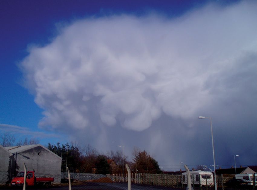
The weather and climate of the tropics – Part 6

                                                              (a)                                                                    (b)
   Weather – May 2008, Vol. 63, No. 5

                                                              (c)                                                                    (d)

                                                    Figure 2. The progress of the Asian monsoon. Streamlines indicate the direction and, by their spacing, the strength of mean monthly surface wind; colours
                                                    indicate mean monthly air temperature at 1000-hpa (approximately 100 m a.s.l.), ranging from white:
The weather and climate of the tropics – Part 6
                                                                                                                                                           Weather – May 2008, Vol. 63, No. 5

Figure 3. (a) Cross-section of the summer monsoon flow over the Indian Ocean and south Asia between 2 °N and 32 °N from radiosonde profiles
at 1200 UTC on 15 July 2006. The tropopause is shown          ; the top of the low-level moist zone     ; and the level of the top of westerly winds   .
(b) Corresponding 500-hPa height          with rainfall data for June–September           adapted from Rao (1976).

  Although the moist monsoon flow is ulti-           spreads across India from the south-east.3            explain the progress of the monsoon than
mately blocked by the Himalaya, heating of           Hence, we need a different mechanism to               the simple motion of moist southwesterly
the Tibetan plateau causes a diurnal cycle                                                                 winds. Indeed the moist flow across India
                                                     3
of winds along valleys crossing the moun-             It may seem strange that the south-west mon-         is partially blocked by the Western Ghats,
tain chain. Daytime anabatic winds may               soon is often associated with southeasterly           the mountains that mark the west coast
become particularly strong, locally reaching         winds. Prior to the MONEX experiments of the          of India (Patwardhan and Asnani, 2000).
                                                     1970s, it was generally assumed that monsoon
gale force along valleys such as that of the                                                               There is copious summer rainfall on the
                                                     rains advanced on predominantly southwesterly
Sun Kosi in Nepal (Nigel Bolton, personal                                                                  western slopes of these mountains, but
                                                     winds, as indicated by the climatological average
communication). These valleys are deep,              pressure gradient across south Asia in summer.
                                                                                                           the area to their lee remains largely dry, in
incised several thousand metres into the             As described in the text, however, it is necessary    a rain shadow, the southwesterly air flow
mountain barrier.                                    for winds from other directions, predominantly        having lost some of its humidity. In order
  Despite the evident northward progress             the south-east, to become established for suffi-      to bring monsoon rains across much of
of the summer monsoon, its advance is                ciently moist low-level air to advance across both    the rest of India, two mechanisms appear
not straightforward and rainfall usually             India and East Asia.                                  important.                                                         131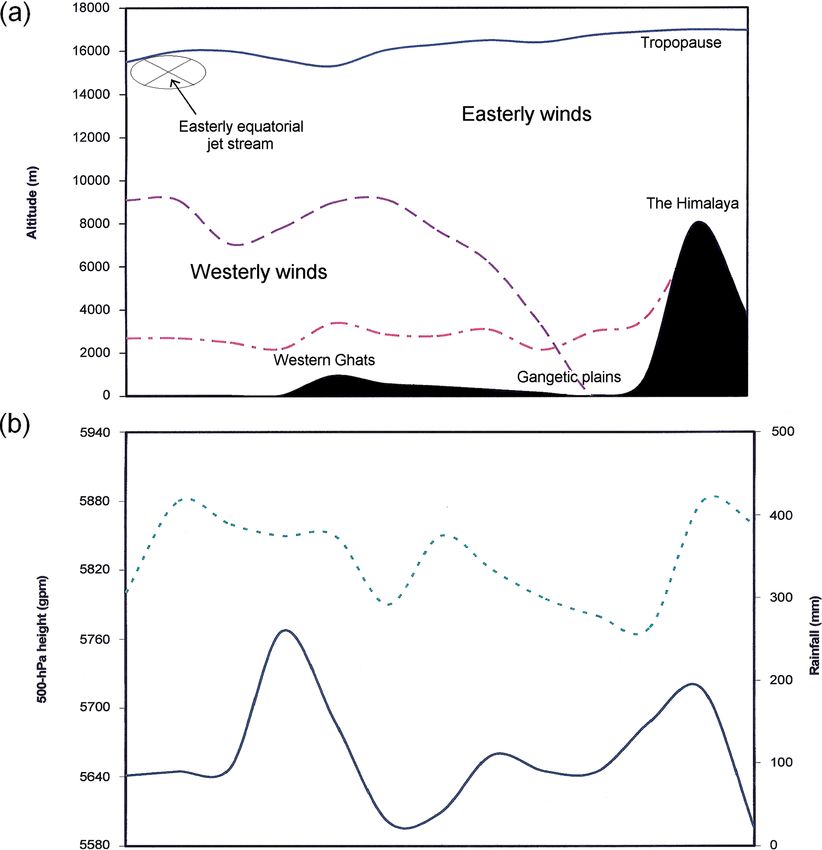
northern India and Nepal, into southern
The weather and climate of the tropics – Part 6
Pakistan. Associated weather systems are
usually carried by easterly waves. Some of
these disturbances seem to have an ori-
gin in tropical revolving storms over the
South China Sea, the vorticity from which
is maintained at high levels and can cross
the south-eastern part of the Himalaya. As
the low-pressure areas cross northern India,
southeasterly winds develop in their wake,
bringing warm moist air from the northern
Bay of Bengal. Thus rainfall is greater in the
east than in the west and is periodic – in
particular across northern parts – spells typi-
cally lasting a few days, followed by several
Weather – May 2008, Vol. 63, No. 5
days of dry weather.
The summer monsoon over
east Asia
East of the Himalaya, the monsoon ‘plum’
rains spread across mainland South-East
Asia and China in three stages. During April,
as fruit trees come into bloom, a shallow
humid southwesterly wind moves across
southern parts. This is followed by south
to southeasterly winds that bring rainfall
as a form of frontal system, known as the
Mei-Yu front, as far north as the Yellow River
during June (Figure 5). Finally, the south-
easterlies reach around 45 °N, bringing most
of the area’s annual rainfall total during July
(Asnani, 1993). Ascent to the uplands of
inland China aids the release of latent heat
and rainfall is copious in central areas, locally
amounting to more than the totals in the
south during the summer.4 Winds must back
at low levels for deep humid air to spread
across the region, since southwesterlies are
partially blocked by high ground in Sumatra,
peninsular Malaysia, Thailand, Burma and
south-western China to depths between 1
and 5 km. These mountain chains have fre-
quent rains, but an area thousands of kilo-
metres in their lee are in rain shadow.
Variations of rainfall in the
Asian summer monsoon
The summer monsoon is highly significant
in terms of rainfall across all the continents
Figure 4. Infra-red, visible and water-vapour satellite images from Meteosat 5 of the south-west on which it develops. Most of the Indian
monsoon over Asia at 0600 UTC on 21 July 2007. In the infra-red picture, the cold cirrus clouds over subcontinent receives about 80% of its rain-
the Bay of Bengal and India form elongated streaks, where the cloud tops are sheared off in the EEJ fall under its influence, mainly between June
(a). The deepest cloud, most likely to produce precipitation is shown as bright white in the visible and September. The depth of southwest-
image (b). The deep humid zone is indicated by light shades in the water-vapour image and can be erly winds at the core of the Asian monsoon
seen to extend as far north as the Himalayan peaks (c). The most humid air is distorted north across reaches about 5 km. However, the depth of
India and Africa by the monsoon flows. Dry air remains over parts of south-west Asia, notably much the most humid air is no more than about
of Pakistan, although a bulge of moist air can be see across much of the Arabian peninsula. The 3 km (Asnani, 1993). Along the southern
remnant ITCZ can be seen over the southern Indian Ocean, near 7 °S. (Courtesy University of Dundee ranges of the Himalaya, very large amounts
Satellite Receiving Station.) of rainfall are deposited with some of the
The first is the development of the pre- the Bay of Bengal and much of southern highest global rainfall totals recorded. For
monsoon trough at the surface over the India, supplying a reservoir of moisture for instance, Cherrapunji in the Assam region of
Arabian Sea. The flow ahead of this trough, convective development. 4
The mean June–August rainfall at Xi’an in cen-
which may contain a tropical depression The second important mechanism is the tral China is 750 mm, whereas that at Haikou on
or cyclone, brings southeasterly winds and motion of small, low-pressure systems from Hainan Island (the extreme south of the country)
132 moisture from the equatorial zone across east to west across Bangladesh, Bhutan, is 650 mm.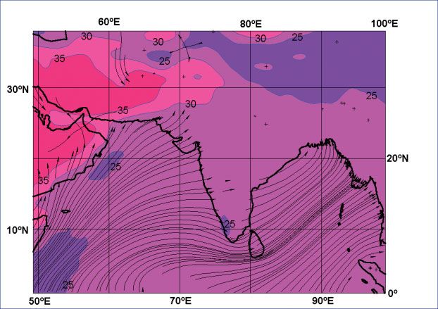
close to the surface and, in some places,

                                                                                                                                                              The weather and climate of the tropics – Part 6
                                                                                                        in particular the bay between Al Ghaydah,
                                                                                                        Yemen and Şalālah, Oman, there is persist-
                                                                                                        ent low cloud and drizzle, associated with
                                                                                                        the Khareef wind. In the relative shelter of
                                                                                                        the Şalālah Plain, which is surrounded by
                                                                                                        mountains, this weather is very popular
                                                                                                        with many an Arab holidaymaker (Membery,
                                                                                                        personal communication)! However, the
                                                                                                        increased moisture in the boundary layer
                                                                                                        also allows deep convection to develop
                                                                                                        from scattered high-based cumulonimbus
                                                                                                        clouds over the Yemeni and Saudi Arabian
                                                                                                        mountains.

                                                                                                                                                           Weather – May 2008, Vol. 63, No. 5
                                                                                                        The Asian winter monsoon
                                                                                                        As Asia cools, the subtropical high becomes
                                                                                                        re-established over the south of the conti-
                                                                                                        nent and northeasterly winds bring dry wea-
                                                                                                        ther across all areas north of about 10 °N.
                                                                                                           The establishment of the winter monsoon
                                                                                                        takes several months (Figures 2(c) and (d)),
Figure 5. The Mei-Yu front over southern China at 1200 UTC on 12 June 2007 observed by MTSAT.
                                                                                                        however; areas of heavy rainfall gradually
This front, the leading edge of the east-Asian summer monsoon, moves north gradually during the
                                                                                                        retreat south in a rather erratic fashion
summer and can be seen between Burma and Kyushu, Japan. Along its northern edge, where warm
                                                                                                        between September and November.
moist air has advanced over cooler air near the surface, is a band of altostratus and altocumulus. At      From late September, the southwesterly
its southern edge is a line of cumulonimbus with a cloud-top temperature around – 80 °C, indicating     winds at low levels decrease, allowing the
an altitude of about 16 km. The deep convection formed over land where the 850-hPa θw was above         Arabian Sea to warm. Indeed, much of the
23 °C. (Courtesy University of Dundee Satellite Receiving Station.)                                     northern Indian Ocean warms, generating
                                                                                                        periodic widespread deep convection and
north-east India, at an altitude of 1313 m, on       India, through south-west Pakistan and Iran,       heavy, thundery rain. Occasional tropical
the southern slopes of the Khāsi Hills, has an       across the Arabian Peninsula. Nevertheless,        depressions or cyclones can be expected after
annual total of 10 824 mm of precipitation,5         some parts of south-west Asia have relatively      the southwesterly winds become light over
more than 5000 mm of it falling in June and          large populations, in particular in coastal        the Arabian Sea and Bay of Bengal between
July.6 As the moist air reaches these ranges,        areas, where trade and fisheries have long         September and December (Galvin, 2008c).
surplus moisture is deposited as rainfall            been important industries.                            During October, the south-east of India
(Dhar and Nandargi, 2005). Away from the                These industries are significantly affected     has another period of rainfall as northeast-
Himalayan slopes, the zone north of 15 °N            by the monsoons, in particular in summer,          erly winds become established. Warm moist
also receives the highest rainfall accumula-         when strong winds make sailing both diffi-         air is carried inland from the Bay of Bengal
tions during the summer monsoon. North of            cult and hazardous. Even in these days of          and a broad zone of cumulonimbus devel-
25 °N, in particular over land, heavy rainfall is    motorised vessels, high seas may be peril-         ops inland of the coast – in particular on
somewhat more limited than further south             ous (J. C. Galvin, personal communication7)        the Eastern Ghats – over an area as much as
(Asnani, 1993).                                      and many traders across the Indian Ocean           several hundred kilometres across (Asnani,
   Figure 4 shows monsoon activity across the        are likely to be confined to port for at least     1993). This is an important period of rainfall
Indian Ocean and Asia in July 2006. The main         part of the summer season. The increased           for this region.
area of convection can be seen between               numbers of fish that the monsoon-related              During the same month, however, the
Thailand and northern India with more limit-         upwelling brings, however, means that fish-        re-established cool north to northeasterly
ed convective cells evident in southern India,       ing tends to peak in summer off Arabia             flow across Japan, Korea and China begins
on the Himalayan slopes and across Tibet. Air        and Pakistan, despite the rough seas. Most         to interact with the re-established westerly
in the upper troposphere can be seen to be           fishing vessels of the area are small and rela-    flow above it, associated with the return of
very moist in all these areas, whilst the Thar       tively fragile. Membery (2001) gave an excel-      the STJ, close to 30 °N. Initially, there is
Desert of India and Pakistan remains under           lent review of the effects of tropical cyclones    convection to middle-tropospheric levels,
the influence of subsided dry air.                   and the monsoon on historical trade around         but maritime stratocumulus soon forms as
   Although moist southwesterlies are                the Indian Ocean.                                  cooling of the boundary layer continues,
observed across the whole of the Arabian Sea            One rather strange aspect of the sum-           at times accompanied by stratus in areas
during the Asian summer monsoon, stability           mer monsoon along the south coast of the           near to the coast (Galvin and Walker, 2007).
and the influence of surrounding mountain            Arabian Peninsula is the effect of upwelling       This brings slight rain and drizzle at times to
chains are sufficient to keep rainfall to very       cool water along this coast. As well as pro-       many areas, including Hong Kong.
low levels in coastal Yemen, Oman, Iran and          moting a good fishery, the upwelling water            The cooling of China, away from the coast,
Pakistan. This results in a desert or semi-          cools the overlying air. This causes conden-       leads to a strong interaction of airstreams
desert climate stretching from north-west            sation from the moist flow to be trapped           and a pall of deep altostratus is common in
                                                     7
                                                       Much of my father’s service in the Royal Navy    the lee of the north-south ranges that form
5
 1961–1990 total; this is more than five times the   aboard ship was spent on the Arabian Sea and       the eastern Himalaya from late November
annual total for most British uplands!               the roughest weather he encountered was dur-       or early December. Widespread rain or snow
6
  The extreme annual rainfall at Cherrapunji         ing the south-west monsoon of 1942 on the          falls from this cloud, in particular over higher
is more than twice this total, as given by           destroyer HMAS Launceston – sufficient to make     ground. Much of central southern China
Guhathakurta (2007).                                 most of the crew sick!                             endures cloudy conditions in winter, rather                           133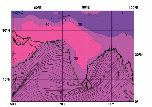
than summer, even though the heaviest                This monsoon circulation has many simi-          the EEJ extends west across much of the
  The weather and climate of the tropics – Part 6

                                                    precipitation (some of it very heavy) falls       larities to that in Asia, but also significant      continent providing the divergence needed
                                                    during the south-west monsoon.                    differences, largely due to the differences in      to generate deep convection.
                                                       The thicker cloud that forms over China        orography and the land-mass distribution of            This monsoon flow is like a giant sea breeze,
                                                    can be a significant hazard to aviation. Much     these two regions. It is also less extensive, the   although on a much larger scale. Its great
                                                    of this cloud deck is at a temperature near       monsoon flow reaching no more than about            scale means that stability cannot be main-
                                                    0 °C, even when several thousand feet deep.       20oN of the equator and deep convection only        tained as it passes inland, in particular late in
                                                    Moderate, occasionally severe icing may be        occasionally seen north of 15oN. The monsoon        the season. As it warms, under the divergent
                                                    encountered by aircraft flying at modest          flow and deep instability spread inland much        upper-tropospheric flow, deep convection
                                                    height through this cloud layer. Such icing       more quickly here than over India, however,         brings thundery rain, most of the energy
                                                    of the airframe or engine can cause loss of       since there are no ranges of mountains to           for which is from the moist low-level flow
                                                    airspeed and stability; ultimately, loss of the   impede the inland flow. Initially, convection       no more than about 4 km deep. The tops of
                                                    aircraft (Galvin, 2008b).                         is scattered, but by late June, as a warm           these cumulonimbus clouds frequently reach
                                                       By late December, the ITCZ is recogniz-        dome develops over north Africa strengthen-         14 km or more with a peak in deep convec-
                                                    able as two bands of cloud across the Indian      ing the easterly winds above about 3 km, the        tion from late afternoon to the early hours
   Weather – May 2008, Vol. 63, No. 5

                                                    Ocean, close to 10 °N and 10 °S.                  southwesterly winds at low levels bring more        of the morning, although associated layer
                                                       Much of the winter season is dry across the    frequent rains north.                               clouds may remain for days, bringing gener-
                                                    whole of south Asia, including parts of sou-         Within the broad-scale structure, there are      ally cloudy conditions with occasional slight
                                                    thern China, Burma, northern Thailand, Laos,      notable variations in the northward extent of       rain. Most of the monsoon rainfall occurs well
                                                    Cambodia and Vietnam. However, although           the deep humid zone on a daily and monthly          to the south of the ME, typically from near the
                                                    areas of large-scale convection are absent,       scale. In the east, the zone has a limited          coast of the Gulf of Guinea to about 10oN.
                                                    slight showers may still affect windward          northward extent, usually south of Lake Chad        Further north, where the depth of moist air
                                                    coasts. A north-west monsoon brings cool          (c. 12oN), which is about 600 km south of its       is rarely more than about 2 km, deep convec-
                                                    continental air from central China across         northern edge across most of west Africa,           tion occurs less often and much is associated
                                                    much of the region. Drier weather also            although occasionally it reaches 20oN. To the       with mesoscale convective systems. These
                                                    spreads briefly into the northern and central     east of Lake Chad, the humid air south of the       will be discussed in Part 8.
                                                    Philippines during March and early April. How-    ITF has a somewhat different character: it has         A conceptual model of the structure of
                                                    ever, monsoon variation is less well marked       a greater instability, but is somewhat drier,       cloud masses and air masses across the west
                                                    over the extreme south of the region and the      following a long land track. This air is not a      African monsoon zones is shown as Figure 6.
                                                    island nations of south-east Asia, where rain     true monsoon, due to its origin mainly over         This shows the change southwards from (A)
                                                    can be expected for much of the year.             the central African land mass.                      hot-dry (hazy) desert to (B) humid-stable
                                                       The relatively cool weather of the win-           To the south of the ME is a moist flow that      transitional to (C) convective, then (D) vigor-
                                                    ter monsoon can be uncomfortable for the          has crossed the equator. Initially this was a       ously convective, (E) deep-tropical stable
                                                    population – in particular those who live in      dry southeasterly from the southern African         and shallow tropical unstable then (F) shal-
                                                    coastal locations, such as Hong Kong, where       mainland. However, it picks up moisture as it       low tropical stable conditions. It can be seen
                                                    cool spells require warm clothing and build-      flows towards the south-facing coast of the         that embedded convection is most likely in
                                                    ings to be heated. Indeed, warnings of cold       Gulf of Guinea. The change of direction of          the centre of zone D. Layer clouds are well
                                                    are issued to the Hong Kong fire brigade if       the Coriolis force as the southeasterly flow        broken in the north of this zone (or may be
                                                    night-time temperatures are expected to           crosses the equator causes it to become             absent) and, although deep and precipitat-
                                                    fall below 10 °C, when the fire risk becomes      southwesterly.                                      ing, the layer clouds in the south of the zone
                                                    significant, as the rooms of otherwise-unhea-        Between April and June, while the Gulf of        do not contain cumulonimbus.
                                                    ted flats are warmed using paraffin stoves        Guinea remains warm, this flow is unstable
                                                    (B.-Y. Lee, personal communication).              and rains may be copious over the sea, as           The west African winter
                                                                                                      well as on land, although the northward
                                                                                                      advance of deep convection is periodic,             monsoon
                                                    The west African summer                           since the pressure gradient between the             As the year wanes and high-level easter-
                                                    monsoon                                           warm Gulf and northern Africa is relatively         lies decrease in strength, the ME moves
                                                                                                      weak, or absent. The wind strengthens as the        slowly southward. The Sahel becomes dry
                                                    Over west Africa, the ITCZ is distorted and       pressure gradient increases from south to           in October as the moist convective zone
                                                    moves north from the coast of the Gulf            north as the summer progresses. This causes         moves south. Steadily more and more of
                                                    of Guinea as the Sahara desert becomes            cooling of the surface water by overturning,        the savannah lands become dry. At its fur-
                                                    increasingly hot during the lengthening days.     the resulting positive feedback causing fur-        thest excursion south, the ME lies along the
                                                    The ME moves north, a few degrees behind          ther strengthening of the pressure gradient,        south-facing coast (~5oN), so that there is a
                                                    the position of the sun overhead at midday        in turn causing further cooling by overturn-        dry northeasterly flow on most days from
                                                    during April and May. The distortion is so        ing. Thus by late June, the flow across the         the central Sahara. The flow is generally hot
                                                    strong that the ME becomes separated from         Gulf is relatively cool, sensible heat having       by day and into the evenings, but may be
                                                    the area of deep convection south of the          being used for evaporation to form exten-           rather cool following nights of clear skies
                                                    inter-tropical front (ITF) and associated thun-   sive cumulus and stratocumulus. Given this          over the desert, the effect seen most often
                                                    dery rain. In the early part of the monsoon       cooling, it is necessary for the moist mon-         across the drier areas of savannah and
                                                    season, convection occurs periodically over       soon flow to be heated and divergence to            semi-desert.
                                                    land and continues over the Gulf of Guinea.       be present aloft for there to be significant           However, the coastal zone does not become
                                                    In June it becomes confined to land, north of     deep convection with associated heavy               completely dry during the winter. There are
                                                    5 °N, as the waters of the Gulf cool. By early    rains, which are largely confined to the land,      occasional incursions of sea air, which, by the
                                                    August, the ME lies at its northward extreme,     since the moist flow is capped over the sea.        latter part of winter, is unstable. The reduced
                                                    between 1500 and 2000 km from the coast of        In this respect, the west African monsoon is        strength or absence of southwesterly winds
                                                    the Gulf of Guinea, over northern Africa.8        rather different from that in southern Asia.        weakens the overturning of the ocean and a
                                                    8
                                                      A full discussion of this process is given in   By June, the troposphere has expanded over          warm Guinea current becomes established
                                                    Leroux (2001), Ch. 1.                             the Sahara Desert as north Africa warms and         (Galvin, 2008a, Figure 1(a)). Cloudy skies are
134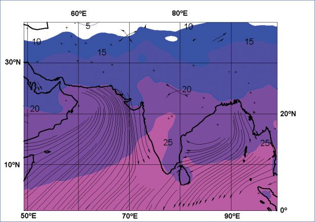
The weather and climate of the tropics – Part 6
                                                                                                                                                              Weather – May 2008, Vol. 63, No. 5
Figure 6. Meridional cross-section of the troposphere over west Africa in northern summer (adapted from Leroux,1970; 1972). SL indicates a squall line
associated with an African Easterly Wave. Zone A lies north of the ME; the (transitional) zone between the ME and the ITF indicated by B; C is a shallow
convective (capped) zone; D is the main convective region of the monsoon under the influence of upper-level diffluence; E is an area of thick layer clouds,
associated with long periods of monsoon rain; F sees the return to capped shallow convection with a transition to layer clouds as surface divergence
becomes re-established. This zone dominates over the Gulf of Guinea and along the Guinea coast in high summer when the total breadth of the monsoon
transition and monsoon rains reaches 1000 km or more.

relatively common throughout the year in            of the predominantly dry Sahara desert. The          there is a flow from the Indian Ocean and
this coastal zone, bringing occasional slight       first is the extensive Ethiopian plateau. Cloudy     precipitation may occur over high ground.
rain or showers. Deep convection occurs             skies and rainfall are present for much of the       The Ethiopian plateau also generates some
south of 5oN across central Africa through          year over this large area of high ground. A          rainfall, although this is mainly somewhat
the winter months.                                  peak in rainfall occurs as the ME moves north        further south than in the northern summer
                                                    across the plateau and deep convection from          months.
Rainfall and the monsoons in                        increasingly moist air becomes widespread.
                                                    North of the plateau, however, the weather
eastern north Africa                                remains predominantly dry. The northern sum-         Monsoons in southern Africa
It might reasonably be thought that all of          mer brings moist air from the Indian Ocean           The broad area of convection spreads south
east Africa across, and to north and south of       north across Somalia, although the strong            during the summer across much of the
the equator would see significant periodic          southwesterly winds of the Asian monsoon             south of the continent, across the savan-
rainfall from the monsoons, but Somalia,            are offshore and the weather is mainly dry           nahs. Most of the south of this continent
Kenya and Tanzania frequently suffer                over the lowlands of the Horn of Africa.             has a long dry winter monsoon season. The
droughts and have become notably dry in                Secondly, there are complex interactions          ME is most notable over east Africa, reach-
recent years, away from their highland inte-        between air masses from the Atlantic and             ing Madagascar and eastern coastal areas
riors. This is largely due to the very shallow      Indian Oceans. The one from the Indian               of Mozambique by November. It is a very
moist boundary layer frequently seen over           Ocean contains more moisture and ascent              diffuse feature further west. As in north-
the western equatorial Indian Ocean (Kiangi,        up the ranges of the East African Highlands          eastern Africa, however, the southern
1989) and the relatively low temperature of         releases its latent heat. This leaves relatively     African monsoon is not a classical form.
the western equatorial Indian Ocean. In turn,       warm dry air at high levels above the moist,            Over land, the situation is complicated
warming of the western Indian Ocean has a           but stable Atlantic air. This stability restricts    first by the presence of high ground, form-
profound effect on rainfall, usually bringing       rainfall north and west of the East African          ing a ‘ring’ around most of the land mass
floods, as in Somalia in 1997 (Camberlin and        Highlands, with rainfall only developing in          and secondly by the convergence of air from
Philippon, 2001) and 2006.                          the presence of additional forcing.                  the Indian and Atlantic Oceans. As described
   However, there are significant complications        In the northern winter, northeasterly winds       above, Indian Ocean air contains more mois-
in the rainfall pattern in eastern Africa, south    are generally dry, although near the equator         ture than that from the Atlantic (Leroux,
                                                                                                                                                                                 135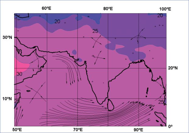
2001), so air from the north-east can release vice versa. There is no upper-tropospheric times, leading to local flash flooding, as
The weather and climate of the tropics – Part 6
more rainfall from instability than air from jet stream (upper-tropospheric winds are occurred in Channel Country, Warrego and
the west. The inland motion of moist air is westerlies) and the depth of the tropopause central west Queensland on 20 and 21
restricted by orography, since the leading remains modest, rarely reaching more than January 2007.
edge of the monsoon flow is no more than about 16 km. An unusual phenomenon precedes the
about 2 km deep. Over central Africa, it is In the provinces of north-east Brazil, as in onset of the Australian monsoon rains in
only when the moist air can flow over the east Africa, the effect of varying off-shore the Gulf of Carpentaria between late August
highlands that deep convection can occur. water temperature affects the climate. The and early November as humidity rises. Here
The East African Highlands, either side of cool equatorial counter-current brings peri- a complex interaction of orography, a moist
the Rift Valley absorb much of this moisture, odic drought and has been a cause of a shallow cool boundary layer and sea breez-
even when the line of convergence of sur- mass exodus of the population (Hastenrath, es sets up the ‘Morning Glory’ cloud roll
face air is well to the west. 1991). as the ME makes a halting advance south
In general, the southward movement of the across the Gulf (Figure 7). The phenom-
monsoon flow during November is accompa- enon is still poorly understood in detail,
nied by a short period of rain. By the end of The Australian summer but development appears dependent on
monsoon the shallow monsoon boundary layer being
Weather – May 2008, Vol. 63, No. 5
the month, it has reached southern Tanzania
and northern Mozambique. Once again, as drawn over Cape York and up its moun-
The distortion of the ITCZ into a mon-
summer wanes, the rainfall area retreats tains by a sea breeze. As this sea breeze
soon flow is perhaps less well marked
north from mid-January to reach northern subsides, it is overturned to form a wave
over northern Australia than in most other
Kenya and Uganda by the end of February, trapped beneath the Trade-Wind inversion.
monsoonal climates and the expansion of
bringing a period of ‘long rains’. This, in turn, This is carried across the Gulf, accompa-
the troposphere is modest, compared with
clears north during April and May, precipita- nied by a roll cloud, close to the line of
that over Asia or north Africa. However,
tion eventually becoming largely restricted surface-wind convergence. It brings a rapid
easterlies strengthen near the equator,
to equatorial Africa. wind increase to around 13 ms−1 and rising
over New Guinea and Java, occasionally
Despite the effect of orography, over humidity. In some cases, the convergence
reaching jet-stream strength, in response
south-western and southern Africa convec- may be accompanied by a line of deep
to the warming of the Australian land mass.
tion at the leading edge of the monsoon convection, but in most cases the roll cloud,
Moist oppressive air precedes convective
often forms a band extending from about which may be up to 1000 km long, brings a
downpours southwards into the marginal
10oS on the coast of Angola, arcing south- stable flow. The overturning is due to west-
semi-desert areas of the country in sum-
eastwards to reach the Mozambique coast erly winds above the inversion, so the cloud
mer. Almost all of northern Australia is
near 30oS when the monsoon reaches its rolls backwards and generates both lift and
dependent on summer rainfall and, as a
peak. Off shore, the warm Mozambique turbulence (Jackson et al., 2002). This can
result, has woody savannah vegetation,
Current, between Madagascar and the main- be a major hazard to light aircraft at low
despite the proximity of parts of the north
land, allows the ME to retain characteristics levels, but the lift ahead of the roll allows
coast of Australia to the equator (the lati-
similar to those of the ITCZ. gliders to ‘surf’ at speed for several hundred
tude of Cape York is less than 11 °S). The ME
kilometres (Thomas, 2003).
reaches about 20–25 °S across Australia at
The South American- the height of the monsoon in late January,
Acknowledgements
its greatest poleward extension usually
Caribbean monsoons in the east of the country, occasionally to With thanks to Nigel Bolton, Richard Young,
Over South America, there is a gradual 25 °S or more. The extensive areas of high Chris Tyson, Clive Jones, Clive Wilson, Martin
northward and southward motion of moist ground in central and northern Australia, Young and Gavin Pretor-Pinney. Dedicated
unstable air. In the southern-hemisphere and the Great Dividing Range along the to my father (15 August 1915 – 5 January
summer, it moves steadily south, crossing east coast, enhance monsoon rains at 2007).
Bolivia, Paraguay, northern Argentina and
Uruguay by late December. The area close
to the equator does not experience a dry
season, although the Caribbean and much
of Central America is mainly dry during the
Northern Hemisphere winter.
In the southern summer, convergence of
a northwesterly wind with southeasterlies
cannot generate the same level of deep
convection as elsewhere, since air from the
north must follow a long land track across
South America, the Andes preventing air
from the Pacific spreading across the con-
tinent. Northwesterlies over south-eastern
Brazil form a relatively dry continental flow.
Here, much of the rainfall comes from mes-
oscale convective complexes (Laing and
Fritsch, 1997).
In the northern summer, the Caribbean
experiences its wet season, although here
it is mainly the result of destabilisation of
the atmosphere as the ITCZ moves north,
rather than a true monsoon, since there
is not a marked reversal of wind direction Figure 7. The ‘Morning Glory’ roll cloud near Burketown, Queensland, Australia, seen from the air.
136 and the flow is from land to sea, rather than (© Russell White.)The weather and climate of the tropics – Part 6
References Galvin JFP. 2008c. The weather and Leroux M. 1970. La dynamique des
climate of the tropics: Part 7 – Tropical précipitation en Afrique occidentale.
Asnani GC. 1993. Tropical meteorology. revolving storms. Weather 63: in press. Publ. Dir. Expl. Météo, No. 23. ASECNA:
G C Asnani: Pune. Dakar.
Galvin JFP, Lakshminarayanan R. 2006.
Camberlin P, Philippon N. 2001. The Weather image: The South-West Monsoon Leroux M. 1972. Climatologie dynamique
stationarity of lead-lag teleconnections and the Equatorial Easterly Jet. Weather de l’Afrique occidentale. Atlas Int. de
with East Africa rainfall and its incidence 61: 296. l’Ouest Africain. IFAN: Dakar.
on seasonal predictability in Detecting Leroux M. 2001. The meteorology and
Galvin JFP, Walker JM. 2007. Weather
and Modelling Regional Climate Change. climate of tropical Africa. Springer/Praxis:
image: Cloudy South-East Asia. Weather
Brunet India M, Lopez Bonillo D (eds), London.
62: 55–56.
Springer-Verlag: Berlin. pp. 291–307. Membery DA. 2001. Monsoon tropical
Guhathakurta P. 2007. Highest recorded cyclones, Part 1. Weather 56: 431–436.
Dhar ON, Nandargi S. 2005. Areas of
point rainfall over India. Weather 62: 349.
heavy precipitation in the Nepalese Patwardhan SK, Asnani GC. 2000. Meso-
Himalayas. Weather 60: 354–356. Hastenrath S. 1991. Climate dynamics of scale distribution of summer monsoon
the tropics. Kluwer Academic Publishers: rainfall near the Western Ghats (India). Int.
Galvin JFP. 2007a. The weather and cli-
Dordrecht. J. Climatol. 20: 575–581.
mate of the tropics: Part 1 – Setting the
scene. Weather 62: 245–251. Jackson GE, Smith RK, Spengler T. 2002. Rao YP. 1976. Southwest monsoon.
Weather – May 2008, Vol. 63, No. 5
The prediction of low-level mesoscale Meteorological Monograph No. I. India
Galvin JFP. 2007b. The weather and cli- Meteorological Department: New Delhi.
convergence lines over northeastern
mate of the tropics: Part 2 − The sub-tropi-
Australia. Austral. Meteorol. Mag. 51: Thomas A. 2003. Soaring the wave.
cal jet streams. Weather 62: 295–299.
13–23. Scribbly Gum, August 2003 http://www.
Galvin JFP. 2007c. Weather Image: Severe abc.net.au/science/scribblygum/
Kiangi PMR. 1989. The monsoons of east
tropical storm over India and South-West august2003/. Accessed 8 March 2008.
Africa and the associated rainfall defici-
Asia. Weather 62: 337–338.
ency. Lectures presented at the seminar on
Galvin JFP. 2008a. The weather and cli- tropical meteorology, ERICE, 26 September - Correspondence to: Jim Galvin,
mate of the tropics: Part 3 – Synoptic-scale 4 October 1986 (WMO/TD-No.277)
Met Office, FitzRoy Road,
weather systems. Weather 63: 16–22. pp. 181–227.
Exeter, EX1 3PB
Galvin JFP. 2008b. The weather and cli- Laing AG, Fritsch JM. 1997. The global
mate of the tropics: Part 4 – Forecasting population of mesoscale convective Email: jim.galvin@metoffice.gov.uk
significant cloud and associated weather. complexes. Q. J. R. Meteorol. Soc. © Crown Copyright, 2008
Weather 63: 31–36. 123: 389–405.
DOI: 10.1002/wea.230
Cumulonimbus with mamma seen on 13 March 2008 at 1600 UTC from Lossiemouth, Scotland. (© Roger Kingham.) 137You can also read