The Wrekin Forest Plan 2015-2020 - With thanks to the Jean Jackson Trust - Telford & Wrekin Council
←
→
Page content transcription
If your browser does not render page correctly, please read the page content below
1

The Wrekin Forest Plan 2015-2020
       Prepared by Pete Lambert, Shropshire Wildlife Trust
        On behalf of The Wrekin Forest Partnership 2015

         With thanks to the Jean Jackson Trust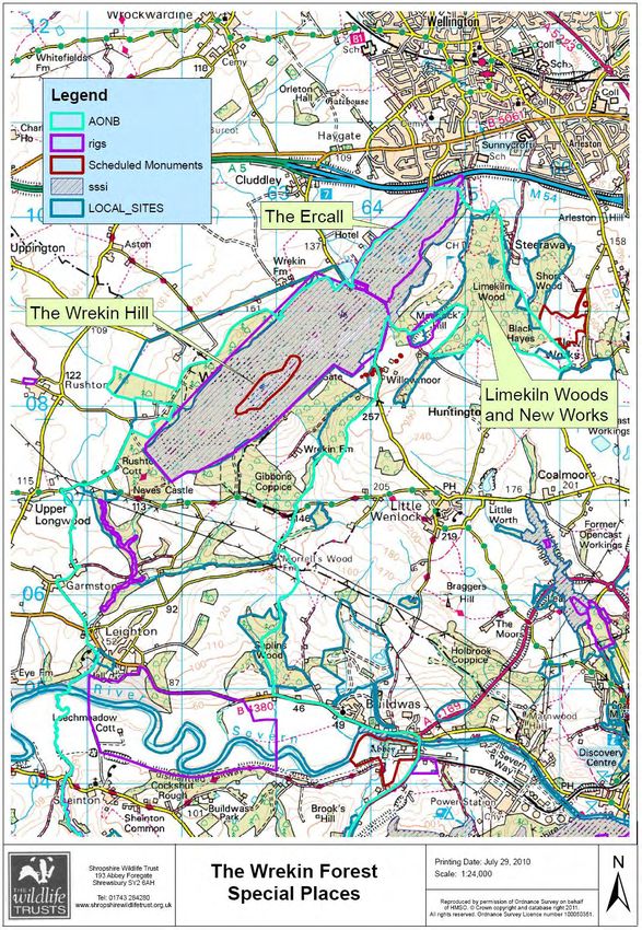
2

Foreword
The Wrekin Forest is an area of countryside to the immediate west of Telford dominated by The Wrekin
Hill and its surrounding woodlands. It is a living landscape with several existing communities and
settlements, an area of considerable ecological and geological value as well as a popular visitor attraction
and area for leisure and recreation.

The area is the modern remnant of a medieval hunting Forest. The Wrekin Hill, The Ercall and other key
sites form a ‘Core area’ of unique geological and biodiversity rich areas surrounded by a wider landscape
of woodlands, fields and settlements which provide a setting to the Core area and a connection to the
surrounding landscape and nearby urban areas (see maps at Section 2).

The Core area is protected by a variety of existing landscape and ecological and geological designations.
The Wrekin Forest Plan not only embraces these formal designations but also encourages greater
recognition and protection of the wider surrounding landscape. After much discussion, the wider area of
the Wrekin Forest is not strictly defined, and no boundary is marked on the maps. (See however the
addendum on the Telford & Wrekin Strategic Landscapes Study 2015).

The purpose of the Wrekin Forest Plan 2015-20 is to provide a framework for the protection, conservation
and management of this landscape for the next five years. Its aim is to help protect and enhance the
integrity of the landscape of the area by understanding its qualities, by providing direction regarding the
way in which the area can balance and address key issues such as the protecting and enhancing
biodiversity, meeting the demands of recreation and leisure, guidance on how to appropriately manage
new development and by recommending a series of actions by which the plan can be achieved.
3

Contents
Foreword 2

Section 1 Context
1.1 Background 4
1.2 The Wrekin Forest Partnership 5
1.3 The purpose of the Wrekin Forest Plan 7
1.4 Vision and aims 8
1.5 Planning 9
1.6 National Policy 11
1.7 Local Policy 13

Section 2. A description of the area and key issues 19
2.1 The Wrekin Forest: An ancient landscape 21
2.2 Biodiversity 22
2.3 Farming 33
2.4 Geology 34
2.5 Archaeology 35
2.6 Recreation and leisure 36

Section 3 Objectives and actions 40
3.1 The Wrekin Forest Partnership 40
3.2 Planning 41
3.3 Biodiversity 42
3.7 Recreation and leisure

Closing comment 45

Section 4 Appendix

Appendix 1 Wrekin Forest Partnership 46
Appendix 2 Bibliography 46
Appendix 3 National examples of landscape planning policy 47
Appendix 4 National and international legislation 48

4

Section 1: Context

1.1 Background
In 2006 Shropshire Wildlife Trust secured Heritage Lottery Funding to support community consultation
leading to the production of a landscape scale conservation plan for an area delineated as The Wrekin
Forest. The Wrekin Forest Landscape Conservation Plan 2008 -2013 [WFLCP] was published at the end of
2007 and commenced with the formation of the Wrekin Forest Partnership [WFP]. The Partnership
functions as an advisory forum to support the implementation of the Plan and aims to ‘focus individual
and group efforts in the conservation of the wildlife, habitats and wilderness values of the Wrekin Forest’
[Source: WFLCP 2008-13]. The Partnership has a formal status as a Working Group of the Shropshire Hills
Area of Outstanding Natural Beauty Partnership. The current chair is the Shropshire Hills AONB
Partnership manager.

The Wrekin Forest Landscape Conservation Plan 2008 -2013 set out its vision to ‘ promote the natural,
cultural and economic future of the Wrekin Forest’, underpinned by the concept of sustainability that is to
live now ‘ in ways which do not compromise the ability of future generations to meet their own needs’.

The Plan set out 15 working principles relating to such themes as biodiversity, outdoor education,
conservation volunteering, geo-diversity and rural heritage. Accompanying the principles were 21
practical initiatives which relate to the principles. Elements of the plan have proved more successful than
others and major themes such as sustainable tourism, transport and access have seen considerable
activity but remain a source of considerable concern and are perceived to lack any progression. Partially
this is because they are immensely complex areas, land ownership is held in multiple hands making
coherent management challenging and tentative engagement by the two unitary authorities has
weakened potential outcomes. The plan expired at the end of 2013 and funding was then sought to
prepare and publish a new Wrekin Forest Plan.

Thanks to the Jean Jackson Fund work began in mid-2014 on this plan which is the result of a period of
public consultation, local discussion and inter-agency negotiation. Since the first Wrekin Forest Plan was
published in 2008 nature conservation has gone further still in embracing the landscape scale approach.
In 2010 Professor John Lawton was commissioned by central government to review nature conservation
in England. The resulting report, ‘Making Space for Nature’ concluded ‘that a step change in nature
conservation was required to establish ‘a coherent and resilient ecological network’ of benefit to wildlife
and ourselves’ [M Jones 2014].

In 2014 the ‘State of Nature’ report published by a collaborative group of 25 UK nature conservation
organisations, highlighted the worrying decline of 60% of species for which we have sufficient data. The
earlier Lawton report advocates a landscape scale approach guided by three key principles, summarized
as ‘bigger, better and connected’. The Wrekin Forest Plan 2015-2020 has adopted this approach and is
driven by the fundamental concern that our natural world is in great difficulty. Ideally key sites would
become bigger, valuable features such as woodlands become more widespread, degraded sites would
recover and the network would be better connected.
5

1.2 The Wrekin Forest Partnership

The Wrekin Forest Plan 2015 -20 is the second cycle of landscape management planning targeted at the
area of open countryside which includes The Wrekin Hill. The first plan, ‘The Wrekin Forest Landscape
Management Plan 2008 -13’ saw the creation of a voluntary forum to support improved communications
between stakeholders and help steer the delivery of the first five year plan. The forum was named the
Wrekin Forest Partnership and was formally constituted as a Working Group of the Shropshire Hills AONB
Partnership, the body responsible for co-ordinating management of the AONB.

The Wrekin Forest Partnership is unincorporated and does not stand as a legal entity. The Wrekin Forest
Partnership reports to the Shropshire Hills AONB Partnership management. As the first plan expired the
Wrekin Forest Partnership commissioned the preparation of The Wrekin Forest Plan 2015-20 which will
be formally integrated into the Shropshire Hills AONB Management Plan. The new plan will be used to
support any depositions to the local planning framework and be utilised as the key document to help
steer partnership activity over the coming five year period.

The Wrekin Forest Partnership aims to bring together relevant partners to work together for the
sustainable natural, cultural and economic future of the ‘Wrekin Forest’. The purpose of the Wrekin
Forest Partnership is to support the development of collaborative projects, provide a forum for discussion
of issues and to promote co-ordination of activity. For current membership grouping see appendix 2.

 The Wrekin Forest Partnership does not hold or expend funds itself, but its work is supported through
key partners including Shropshire Wildlife Trust, the Shropshire Hills AONB Partnership and Local
government authorities. The Partnership will also, as part of its remit to promote positive management of
the landscape, examine possible structures or delivery mechanisms for the best long-term benefit of the
area, such as a free-standing charitable trust.

1.2.1 The Wrekin Forest Partnership: Terms of reference

The Wrekin Forest Partnership utilises the following fourteen terms of reference which help define the
scope and parameters of activities that the group should be concerned with in relation to the
management of the Wrekin Forest landscape. The Wrekin Forest Partnership seeks to……

    1.   Support voluntary initiatives aimed at working together that contribute to the landscape
         conservation of the Wrekin Forest.
    2.   Be a representative group with a strong advisory role offering a consensus building function for
         the future landscape conservation of the Wrekin Forest.
    3.   Support the continued protection of the designated landscape elements, to enhance and extend
         where possible and promote complimentary research and monitoring throughout the Wrekin
         Forest.
    4.   Support the recommendations of the Wrekin Hills Geodiversity Plan, facilitate future review and
         monitoring of geological conservation, seek opportunities to enhance the management
         arrangements for the geological resource and promote wider understanding of the geodiversity
         of the Wrekin Forest.
    5.   Support the positive management of wildlife throughout the Wrekin Forest.
6
6. Work to support the Shropshire Biodiversity Action Plan in regard to protecting threatened
habitats, seeking opportunities to restore or create wildlife habitats, support appropriate
management and promote public understanding.
7. Support and promote environmentally sustainable agriculture through the development of
beneficial collaborations, information sharing, advice and public education.
8. Support the active conservation of the archaeological and industrial heritage of the Wrekin
Forest.
9. Promote, support and enhance relationships between the Wrekin Forest and the surrounding
urban communities of Wellington and Telford and seek to support the development of a wider
green space planning strategy which includes the Wrekin Forest.
10. Support the development of an integrated high quality multi user network of trails that supports
positive exploration and enjoyment of the Wrekin Forest.
11. support community-wide initiatives to promote a cleaner, safer natural environment, seek to
develop projects that contribute to raising public awareness of environmental issues, and
provide a forum for Wrekin Forest-wide debate
12. Promote public understanding and appreciation of the natural, cultural and historical resources
of the Wrekin Forest through supporting new research, literature and educational initiatives.
13. Promote the positive use of the Wrekin Forest for the purposes of health, leisure and recreation.
14. Promote and support opportunities to positively engage and involve the general public in the
conservation of the Wrekin Forest.
1.2.2 Consultation
The process of writing The Wrekin Forest Plan 2015 – 20 commenced with the drafting of an agreed
briefing document. This document was used to secure generous funding form the Jean Jackson Trust and
in June 2014 plan preparation commenced. Regular sessions of the Wrekin Forest Partnership have
reviewed and debated various elements of the Plan and the partnership has commented on two drafts.
Further consultation has been conducted with various stakeholders and in the late autumn 2014
Shropshire Wildlife Trust ran a public opinion survey. Local radio and newspapers helped raise awareness
of the survey and a total of 267 respondents replied on-line or in hard copy form.
The Wrekin Forest Plan public opinion survey 2014 revealed that 65% pf respondents considered
inappropriate development as the ‘greatest threat’ to the future of the Wrekin Forest. Over 70% of the
same group strongly agreed that they would like to see ‘increased protection and recognition of the
Wrekin Forest in planning policy. Many conceded that small scale developments might be acceptable and
enhancements to improve countryside access and visitor infrastructure would be welcome.7 1.3 The purpose of the Wrekin Forest Plan The purpose of the Wrekin Forest Plan 2015-20 is to support and provide a framework for the protection, conservation and management of this special landscape for the next five years and beyond. The Plan has two elements, firstly as a statement to go forward and be considered in the current Shaping Places consultation and secondly it includes a series of options and activities that are considered by The Wrekin Forest Partnership as making a potentially positive impact on the future of The Wrekin Forest. Landscape scale conservation can be defined as the careful management of change. It is about sharing and revealing the significance of places and ensuring their special qualities are protected, enhanced, understood and enjoyed by present and future generations. The Wrekin Forest Plan will help stakeholders in the future of the area work in collaborative ways to achieve consensus and support positive action to sustain and enhance the landscape and its unique natural and historic environmental values. The Wrekin Forest Plan is not only a framework for positive landscape scale management but also a statement to be used to influence local and regional planning policy. The Wrekin Forest area straddles the boundary of two Unitary Authorities and it is intended that each will acknowledge through their local planning frameworks the importance of the Wrekin Forest. Cross border cohesion in planning policy is in line with Local Government protocols relating to inter-council working. The Plan seeks to initiate enhanced policy driven development control to prevent deterioration of the values identified within the document. The Plan aims to support specific statements being made in local policy to support the recognition of the Wrekin Forest in long term development planning strategy.
8

1.4 Vision and aims
1.4.1 The vision

The vision for the Wrekin Forest is for those concerned with the future of the area to work collaboratively
to ensure that future generations continue to be able to enjoy access to an area rich in natural, cultural
and historic heritage. That the residents and businesses of the area thrive and the unique values of the
landscape are not degraded by neglect, poor understanding, or inappropriate development and
management. The Wrekin Forest of the future will be welcoming to visitors yet resilient to visitor
pressure; safely accessible to all travellers; a pleasant place to live and work; a refuge for wild creatures
and wild places; and its story easily heard. Its expanding woodlands will bear timber and harbour wildlife,
the farms cultivate wisely and the Forest’s springs will deliver clean water to the Severn.

1.4.2 Aims

The aim of the Wrekin Forest Plan is to ….

         • secure the natural, cultural and economic future of the area

         • sustain and enhance the existing quality of the landscape

         • strengthen the protection and management of existing areas of high quality
         designated wildlife habitat and create additional habitats which may provide
         buffers against development.

         • establish corridors and stepping stones of green space to link habitat islands to
         allow movement of wildlife across the wider landscape.
9
1.5 Planning
The Wrekin Forest lies partially within the Borough of Telford & Wrekin and also partially within the
boundary of Shropshire Council and includes all or part of the parishes of Wellington, Little Wenlock,
Buildwas, Wroxeter and Uppington, and Leighton and Eaton Constantine.
The area is subject to European legislation and national and local planning policy and includes several
statutory and non-statutory designations.
1.5.1 Designations
Shropshire Hills Area of Outstanding Beauty
The Shropshire Hills Area of Outstanding Natural Beauty [AONB] was designated in 1958 under the
2
National Parks and Countryside Act 1949 and covers an area of 802 km . Mostly in the southern part of
Shropshire, the north eastern extremity of the AONB takes in the Wrekin Hill, The Ercall and neighbouring
lands and woods.
The Shropshire Hills AONB was designated to conserve and enhance natural beauty, which ‘is not just
about the look of the landscape, but includes landform and geology, plants and animals, landscape
features and the rich history of human settlement over the centuries. The legal duty for the Shropshire
Hills AONB rests with Shropshire Council supported by formal ties to Telford and Wrekin Council in
respect of the part of the SHAONB which lies within the TWC boundary.
Sites of Special Scientific Interest
Within the Wrekin Forest are 3 Sites of Special Scientific Interest [SSSI]. These sites are designated under
the Wildlife and Countryside Act 1981 and offer statutory protection for land notable for its geology and
biodiversity.
The SSSI’s in the Wrekin Forest area are The Wrekin Hill and Ercall, Lydebrook Dingle and Chermes Dingle.
The Wrekin and Ercall SSSI was notified in 1986 and extends over an area of 283.3 hectares. The
designation recognises the geological importance of the area and the natural interest. The SSSI network is
regulated by Natural England who work with landowners to establish sympathetic management regimes.
Local Nature Reserves
There are 2 Local Nature Reserves in The Wrekin Forest ‘The Ercall and Lawrence Hill’ and ‘Limekiln
Woods’. Local Nature Reserves are established by Local Authorities to recognise the combined
conservation and educational value of a natural site. The LNR agreement includes the imposition of bye-
laws to help protect the site.
Regionally Important Geological Sites
Geological sites valued for their educational role or as important examples of rock type or geological
process, are designated as Regionally Important Geological Sites [RIGS]. Shropshire Geological Society
identified and designated the Wrekin Hill RIGS: the Ercall Quarry, Forest Glen, Maddocks Hill and
Lydebrook Dingle.10
Scheduled Ancient Monuments
Notable archaeological sites are protected by being on the Scheduled Ancient Monuments [SAM] register,
which is administered by English Heritage under legislation from the 1979 Ancient Monuments and
Archaeological Areas Act. The Wrekin Hill Fort and land near New Works are all designated as Scheduled
Ancient Monuments. These sites should all have management plans and be shown on local authority
development plans. In some cases management plans have not yet been formulated or agreed.
Wildlife Sites
Wildlife Sites are a non-statutory designation given by County Wildlife Trusts to assist the wider
conservation of habitats and landscape. Informal management arrangements are sought with the owners
to support sympathetic care of the sites concerned. The Wrekin Forest includes a number of Wildlife Sites
including areas outside the statutory designations - The Wrekin Hill, Devils Dingle, Smalley Hill, Moreton
Coppice and Simpson’s Pool and Marmers Covert.
1.5.2 Designation summary table
Designation Site /Area Management By Whom?
Arrangement
AONB Shropshire Hills AONB
Partnership
SSSI The Wrekin and Ercall Management NE
Chermes Dingle Agreement Local
Lydebrook Dingle with Landowners Landowners
LNR The Ercall and Lawrence Hill Joint TWC
Limekiln Woods Management SWT
Agreement
RIGS Wrekin Hill Informal SGS
Ercall Quarry agreements with Local
Forest Glen landowners landowners
Maddocks Hill
Lydebrook Dingle
SAMs The Wrekin Hillfort Management EH
New Works agreement Local
with landowners landowners
Wildlife Sites The Wrekin Hill [Non-SSSI] Informal
Devils Dingle agreements with
Marmers Covert landowners
Moreton Coppice and Simpson’s Pool
Leasowes Farm [2 species rich grasslands]
Other sites of nature Smalley Hill Management Veolia/SWT
conservation interest agreement with
landowners11
1.6 National Planning Policy
National planning policy is provided by the National Planning Policy Framework (NPPF)
supported by the Planning Practice Guidance (PPG).
1.6.1 National Planning Policy Framework (NPPF)
The NPPF was adopted in 2012. This framework informs all issues which relate to planning.
All policies contained in the NPPF are potentially applicable to the Wrekin Forest. The following are of
particular relevance to the Wrekin Forest:
Achieving sustainable development
Supporting a prosperous rural economy ( section 3)
Promoting sustainable transport ( section 4)
Delivering a wide choice of high quality homes ( section 6)
Requiring good design ( section 7)
Promoting health communities ( section 8)
Meeting the challenge of climate change, flooding and coastal change ( section 10)
Conserving and enhancing the natural environment ( section 11)
Conserving and enhancing the historic environment ( section 12)
The NPPF states that; the planning system should contribute to and enhance the natural and local
environment by:
protecting and enhancing valued landscapes, geological conservation interests and soils;
recognising the wider benefits of ecosystem services;
minimising impacts on biodiversity and providing net gains in biodiversity where possible,
contributing to the Government’s commitment to halt the overall decline in biodiversity,
including by establishing coherent ecological networks that are more resilient to current and
future pressures;
preventing both new and existing development from contributing to or being put at
unacceptable risk from, or being adversely affected by unacceptable levels of soil, air, water or
noise pollution or land instability;
And
remediating and mitigating despoiled, degraded, derelict, contaminated and unstable land,
where appropriate.’
In relation to agricultural land ‘Local planning authorities should take into account the economic and
other benefits of the best and most versatile agricultural land. Where significant development of
agricultural land is demonstrated to be necessary, local planning authorities should seek to use areas of
poorer quality land in preference to that of a higher quality.’
The NPPF supports the aim of enhancing and protecting both the Core area and the Wider Forest in terms
of its value as a setting and function as part of a fully connected landscape. The NPPF states ‘Local
planning authorities should set criteria based policies against which proposals for any development on or
affecting protected wildlife or geodiversity sites or landscape areas will be judged. Distinctions should be
24
made between the hierarchy of international, national and locally designated sites, so that protection is12
commensurate with their status and gives appropriate weight to their importance and the contribution
that they make to wider ecological networks.’
The NPPF requires local planning authorities to ‘set out a strategic approach in their Local Plans, planning
positively for the creation, protection, enhancement and management of networks of biodiversity and
green infrastructure’. The Framework states that ‘great weight should be given to conserving landscape
and scenic beauty in National Parks, the Broads and Areas of Outstanding Natural Beauty, which have the
highest status of protection in relation to landscape and scenic beauty.’
The NPPF seeks to minimize the impacts on biodiversity and geodiversity by requiring that planning
policies that should:
plan for biodiversity at a landscape-scale across local authority boundaries;
identify and map components of the local ecological networks, including the hierarchy of
international, national and locally designated sites of importance for biodiversity, wildlife
corridors and stepping stones that connect them and areas identified by local partnerships for
habitat restoration or creation;
promote the preservation, restoration and re-creation of priority habitats, ecological networks
and the protection and recovery of priority species populations, linked to national and local
targets, and identify suitable indicators for monitoring biodiversity in the plan;
aim to prevent harm to geological conservation interests; and
where Nature Improvement Areas are identified in Local Plans, consider specifying the types of
development that may be appropriate in these Areas.
The NPPF requires that when ‘determining planning applications, local planning authorities should aim to
conserve and enhance biodiversity by applying the following principles:
if significant harm resulting from a development cannot be avoided (through locating on an
alternative site with less harmful impacts), adequately mitigated, or, as a last resort,
compensated for, then planning permission should be refused;
proposed development on land within or outside a Site of Special Scientific Interest likely to have
an adverse effect on a Site of Special Scientific Interest (either individually or in combination with
other developments) should not normally be permitted. Where an adverse effect on the site’s
notified special interest features is likely, an exception should only be made where the benefits
of the development, at this site, clearly outweigh both the impacts that it is likely to have on the
features of the site that make it of special scientific interest and any broader impacts on the
national network of Sites of Special Scientific Interest;
development proposals where the primary objective is to conserve or enhance biodiversity
should be permitted;
opportunities to incorporate biodiversity in and around developments should be encouraged.
planning permission should be refused for development resulting in the loss or deterioration of
irreplaceable habitats, including ancient woodland and the loss of aged or veteran trees found
outside ancient woodland, unless the need for, and benefits of, the development in that location
clearly outweigh the loss; and
the following wildlife sites should be given the same protection as European sites:
- potential Special Protection Areas and possible Special Areas of Conservation;
26
- listed or proposed Ramsar sites; and
- Sites identified, or required, as compensatory measures for adverse effects on European
sites, potential Special Protection Areas, possible Special Areas of Conservation, and listed or
proposed Ramsar sites.13 The presumption in favour of sustainable development does not apply where development requiring appropriate assessment under the Birds or Habitats Directives is being considered, planned or determined. ‘To prevent unacceptable risks from pollution and land instability, planning policies and decisions should ensure that new development is appropriate for its location. The effects (including cumulative effects) of pollution on health, the natural environment or general amenity, and the potential sensitivity of the area or proposed development to adverse effects from pollution, should be taken into account. 1.7 Local Planning Policy Local Planning policy applicable to the Wrekin Forest is currently the saved policies of the Wrekin Local Plan and the Telford& Wrekin Local Development Framework Core Strategy. The Development Plan documents will be replaced by the new Shaping Places Local Plan in 2016, which will be known as the Telford and Wrekin Local Plan when complete. . 1.7.1 Core Strategy 2006 – 2016 The Telford and Wrekin Council Core Strategy 2006 – 2016 sets out the borough's 'spatial development strategy' (i.e. what development should take place and where) and contains planning policies to deliver this strategy. A key principle of the Core Strategy is to support the development of sustainable communities. Local development should therefore actively seek to enhance climate change resilience ; minimize pollution on land, in water and in the air; minimize waste and make more efficient use of natural resources; protect and improve bio-diversity ; promote sustainable lifestyles; and create cleaner, safer and greener neighbourhoods for all. Key policies relating to the Wrekin Forest are: CS1 Homes – housing development will seek to provide every household in the Borough with an affordable, decent and appropriate home. The spatial distribution of new homes across the borough will be consistent with the Spatial Development strategy, the overwhelming majority of new homes will be built in the strategic sites of Lightmoor, Lawley and East Ketley. The type, size and tenure of new and improved homes will meet local need, and be delivered in a way that creates locally inclusive sustainable communities. CS 7 Rural Area - Development within the rural area will be limited to that necessary to meet the needs of the area. It will be focused on the settlements of High Ercall, Tibberton and Waters Upton. New housing development will be expected to deliver affordable housing to the level of 40% of all such development. Outside of these settlements development will be limited and within the open countryside will be strictly controlled. CS8 Regeneration - Development associated with regeneration initiatives will be supported, where it improves the quality of existing housing; assists the creation of job opportunities; Addresses the priorities identified within Neighbourhood Improvement Plans; and demonstrably meets identified rural regeneration needs.
14
CS9 - Accessibility and Social Inclusion
The Local Development Framework (LDF) aims to improve social inclusion and accessibility
By making sure that everyone is afforded reasonable opportunity to access homes, work,
Schools, recreation and open space, sports facilities, healthcare, food shops and other key
Services.
Development will promote sustainable forms of transport, by providing public transport, cycling
and pedestrian routes to improve accessibility;
New development will be located in existing centres to minimise the distance people travel so
that they are accessible by public transport, walking and cycling;
Increase the safety of travel, by addressing crime and fear of crime through implementing
Urban design policy;
Include measures that minimise the negative environmental impacts of travel including
Congestion, air pollution and noise;
Promote the advancement of telecommunications, whilst minimising their social, economic
And environmental impact.
CS10 Community Facilities - The loss of existing land or buildings used for the benefit of the community
will be resisted.
Only where a lack of need is demonstrated or where acceptable alternative provision exists or
Is proposed concurrently, will development for non-community uses be considered.
The provision of new community facilities or improvements to existing community facilities to
Meet the needs of local residents will be supported.
New facilities: should be located in Town, District, Local Centres and key rural settlements;
Facilities outside the above locations, should have good accessibility by foot, cycle and public
Transport;
New facilities that demonstrate both environmental and social benefits to the local community
may exceptionally develop on open space.
CS11- Open Space - This policy seeks to protect and enhance areas of open space, both formal and
informal. Development on open space will only be permitted if it can be demonstrated that there will be
significant community and environmental benefits delivered by a proposal.
CS 12 - Natural Environment - The natural environment of the Borough will be protected and enhanced.
The natural environment of The Shropshire Hills Area of Outstanding Natural Beauty and that of the
Borough’s Sites of Special Scientific Interest, Areas of Special Landscape Character, Local Nature Reserves,
Wildlife Sites and Ancient Woodland sites will be protected from development that has the potential to
adversely impact on its sustainability. Biodiversity, including habitats, and geodiversity will be protected
from development. Where appropriate, development that delivers enhancement will be consistent with
local biodiversity targets and objectives.
The Core Strategy includes recognition of the importance of the network of designated sites such as Sites
of Special Scientific Interest and upholds its legal obligation to protect these sites in collaboration with
Government Agencies and other interested parties. In section 3 the Core Strategy lists the natural assets
of the Borough and assesses in general terms their condition and role in the future spatial development of
the area.
The Core Strategy incorporates the aims and objectives of The Shropshire Local Biodiversity Action Plan
(incorporating Telford & Wrekin, April 2006] which identifies the issues relating to the diversity of local
plant and animal life. Specific issues are addressed in its Habitat and Species Action Plans. .15
CS13 - Environmental Resources
The environmental resources of the Borough will be used with prudence within environmental
limits.
The production of energy from renewable sources will be supported where this is consistent
with the statements within this policy and others contained within the Development Plan and
national guidance.
Development that reduces the risks of contaminated land to the environment and human health
Will be supported. That which has detrimental impacts on the environment, including the quality
Of land, air or water, will be resisted if satisfactory mitigation cannot be achieved.
Development will avoid increasing the risk of flooding. Where appropriate and consistent with
The policies of the Development Plan and local strategies, development will integrate measures
for sustainable water management.
CS 14 - Cultural, Historic and Built Environment
The Borough's cultural, historic and built environmental assets will help underpin the overall quality of
life for the community and visitors alike. These assets help deliver wider economic, social, and
environmental objectives and along with the natural environmental assets, they create the Borough's
local character and distinctiveness. The aim of this policy is to protect and enhance the Borough's existing,
unique built and cultural assets and to deliver new development to support a rich cultural fabric by:
Protecting and enhancing the historic environment, cultural and built heritage within the Borough to
maintain and improve quality of life; Conserving and enhancing the cultural and heritage assets of the
Ironbridge Gorge World Heritage Site; Supporting the creation of a cultural quarter and night time
economy in Telford Town Centre; Encouraging sustainable tourism related development in the Borough;
Locating new cultural activities and facilities in accessible locations; Using public art to further enhance
local distinctiveness.
CS15 - Urban Design
The design of development will assist in creating and sustaining safe places, strengthening
local identity and projecting a positive local image. It will positively influence the appearance
and use of the local environment.
1.7.2 Wrekin Local Plan (saved policies)
As with the NPPF, all saved policies in the Wrekin Local Plan have the potential to have an effect in the
Wrekin Forest area.
Relevant sections (and policies ) are as follows :
Chapter 2 – Environment – Future development is understood within the framework established
within this chapter. The principles of sustainable development, the use of natural resources,
environmental health and urban design are all considered and give rise to policy statements.
Chapter 4 – housing – the concept of sustainable development underpins the Councils approach
to housing policy. The majority of new housing will be built in the urban centres with a small
amount being constructed in rural areas. Rural developments must meet certain criteria for
instance in terms of layout , reflection of local character, avoiding negative impingement on a16
rural settlements wider landscape setting. The various policies will control development within
the Wrekin Forest, though not prevent some development.
Chapter 8 – Countryside and open land – this chapter of the Wrekin Local Plan review the extent
of the open land and countryside found within the Borough and sets out a series of policy
statements. Resistance to loss of open countryside, infilling , harm to designated areas and losses
to the setting of the urban areas are all made clear within the section. The following are some of
the relevant policies from the plan in more detail:
OL2 Designated Areas.
This policy states that the Council will not permit development which is likely to adversely affect, either
directly or indirectly, the following sites of national importance unless the development is of an overriding
national or international interest and there are no alternative sites.
The Shropshire Hills Area of Outstanding Natural Beauty
Sites of Special Scientific Interest
The policy also states that development which is likely to adversely affect either directly or indirectly , the
following sites of regional and local importance will not be permitted unless the applicant can
demonstrate that the benefits of the proposal significantly outweigh the importance of the area:-
1. Areas of Special Landscape Character
2. Local Nature Reserves
3. Wildlife Sites
4. Ancient Woodland Sites as listed in the Shropshire Inventory of Ancient Woodland. Ancient
woodlands are those which have been continuously wooded since at least 1600.
The policy states that ‘The loss of any habitat must be fully compensated for by the creation or
enhancement of other habitats of equal or greater value in the local area.’
AONB, SSSI, LNR all have a statutory basis. “Development control decisions will take full account of the
specific factors which led to the designation of these areas and help to sustain or indeed further the
purpose of the designation” [ 8.3.2 Wrekin Local Plan 1995-2006].
Saved policy OL6 Open Land states that throughout the District, the Council will protect from
development locally important incidental open land within or adjacent to built-up areas where that land
contributes to the character and amenity of the area, has value as a recreational space or importance as a
natural habitat. Under this policy many areas of land of low biodiversity value can also be considered as
locally valuable due to the range of other values.
OL6 OPEN LAND
Policy OL11 Woodland and trees
This policy states that the Council will seek to retain and enhance the contribution that trees and
woodland, (especially areas of ancient woodland) make to the landscape character of the District. This will
be promoted by:-
a) Making Tree Preservation Orders, where appropriate, to protect trees and woodland areas of
significant amenity value;
b) Resisting development proposals that would result in the loss of trees which make a valuable
contribution to the character of the landscape, a settlement or its setting or have a significant ecological
value. ;17
c) Supporting initiatives for woodland management, tree planting and creation of new hedgerows, where
appropriate, through legal agreements.
Policy OL12 Open land and contributions from new development
In considering development proposals, the Council will seek the following in relation to landscaping and
the provision of open land:-
1. an appropriate landscape setting in accordance with the location, nature and scale of the
development;
2. protection and appropriate enhancement works to areas of Green Network which are clearly
related to the development site in physical or visual terms;
3. footpath, bridleway and cycleway links, to replace those lost as a result of the development, or
considered necessary as a result of the development;
4. protection and appropriate enhancement of important ecological or archaeological sites and
wildlife habitats that may be adversely affected by the development;
5. protection of all legally protected species affected by the development;
6. Where a recreation or sports facility, or other feature is lost through development, a suitable
replacement facility or feature of equal or enhanced quality and accessibility must be provided.
Telford and Wrekin Local Plan 2015 [previously known as Shaping Places]
The Telford and Wrekin Local Plan 2015 is the name of the new Development Plan for the Telford and
Wrekin area and will replace the LDF Core Strategy and Wrekin Local Plan saved policies.
It will set out policies and priorities for development in relation to housing, employment, green space,
retail, local centres, and transport and community facilities until 2031.
A key element of the Telford and Wrekin Local Plan will be the recognition and promotion of green
infrastructure. The Wrekin Forest is recognised in the plan as a ‘Strategic landscape ’ and given status in
Policy NE4 and in text in paragraph 6.23.
1.7.3 Green Infrastructure
Green infrastructure is the collective term for all green space and natural features and is a term which is
both recognized by the NPPF and has been adopted by all new Local Plans in the UK. It includes all public
and private green areas such as parks, sports pitches and private gardens as well as all urban and rural
green features such as highway verges, street trees and planters, hedges, woods and fields.
As part of the Shaping Places process Telford and Wrekin Council have produced two key evidence base
documents relating to Green Infrastructure:
Green Infrastructure Framework Evidence & Analysis document.
This document has been produced to provide a database of the current provision and performance of
green infrastructure in Telford and Wrekin. The Evidence & Analysis document shows that over 90% of
the borough is green infrastructure. Green infrastructure has been, and remains, a significant component
in the planning of the borough. It is key to its image and identity, its economic prosperity and its social
health and well-being as well as the borough's sustainability and resilience to climate change.
Local Green Infrastructure Needs Study
This study has assessed the existing provision of green infrastructure in the borough against local need.
This study replaces the previous PPG 17 Open Space, Sports and Recreation Facilities Study.18
http://www.telford.gov.uk/info/20172/planningpolicyandstrategy/556/greeninfrastructure
Both of these documents will provide the evidence for policies on green infrastructure in the Shaping
Places Local Plan. They:
Provide a greater understanding of the many types of green and natural resources that are in
the borough and what they can do
Provide more information (Evidence & Analysis) about the borough green and natural resources
so that the council can make more informed and therefore better decisions about how to plan,
design and manage the green and natural resources
Help the council improve its planning policies on the planning and design of green infrastructure
Help the council improve the planning, design and management of its green resources
Provide local neighbourhoods and communities with the borough wide context about green and
natural resources, consequently helping communities better understand how to plan, design
and manage their green and natural resources in greater detail
Assist in understanding the relationship to and contribution of green infrastructure to the
economic, social and environmental life and planning of the borough
Both documents demonstrate that the Wrekin Forest contains a suite of high value sites which score
highly against green infrastructure values with a range of benefits such as health and well-being, aesthetic
value, water features, locally available open space, social value and biodiversity values.19 Section 2: A description of the area and key issues The Wrekin Forest is a rural landscape which includes the Wrekin and Ercall Hills (which are the northern extent of the Shropshire Hills Area of Outstanding Natural Beauty) and the rural area surrounding it extending north and east to the urban areas of Telford and Wellington, and south to the River Severn. Maps 1 and 2 below indicate the Wrekin Forest area in general, but this Plan does not define an exact area for the Wrekin Forest. Particular initiatives suggested by the Plan may work over different areas relevant to that activity. Map 1: The Wrekin Forest Special Places
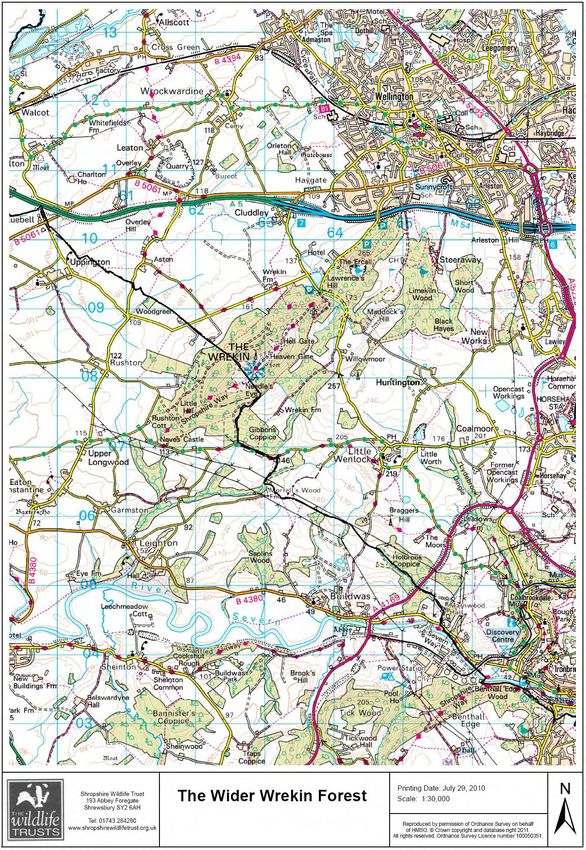
20

Map 2: The Wider Wrekin Forest

The Wrekin Forest lies within the County of Shropshire and overlaps the administrative boundaries of
Shropshire Council, Telford and Wrekin Council and Wellington Town Council. The Parish Councils of Little
Wenlock, Buildwas, Wroxeter and Uppington, and Leighton and Eaton Constantine also fall wholly or
partially within the boundaries of the Wider Forest.
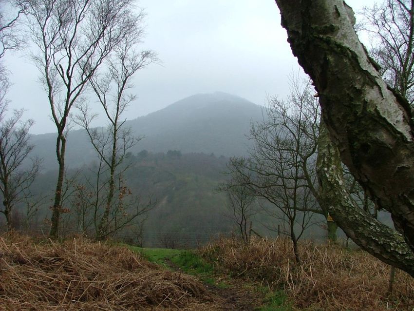
21

2.1 The Wrekin Forest: An ancient Landscape
At the heart of the Wrekin Forest is The Wrekin Hill [407m] an isolated whaleback of very old volcanic
rock. Though never actually a volcano, it rears up powerfully and steeply nevertheless. It has a distinctive
ridge–like profile and is part of a South-West to North-east trending series of hills. The Wrekin Hill is the
best known hill in Shropshire and as such is a cultural icon. A popular saying refers to going ‘all round the
Wrekin’ to imply a long indirect journey or rambling way of speaking and a local toast offers greetings
‘Here’s to all friends round The Wrekin’.

The Wrekin Hill is the subject of a number of local legends, the most involve giants. Long standing public
interest and attachment has meant it has been, and is, the focus for major celebrations, cultural and
sports events. In the past the Wrekin Wakes involved a battle between local farm labourers and colliers
from the pits, this particular event was stopped by the local clergy because of its rowdiness! The recent
millennium was marked by a lit beacon on the hill and there are annual Wrekin Fell races and a barrel
race. The Wrekin Hill means many things to many people. For some a place of homecoming,
remembrance, celebration or re-union, its human living dimension is not to be underestimated.

The Wrekin Forest has seen the impact of man for millennia, a 2500 year old hill-fort encircles the summit
of the Hill, a Roman road skirts the northerly limits of the Forest and industrial scars from all ages mark
the land. In medieval times The Wrekin Hill stood at the centre of a large area under Royal Forest Law,
extending to Albrighton, nearly reaching Shrewsbury, down towards Bridgnorth and out just beyond
Shifnal to the east and north up near Newport. Forest Laws had been imposed following the Norman
invasion of 1066, and were operated through a system of local courts that set fines for damage to trees
and game. By the 1300s the Royal Forests of Shropshire had been broken up into smaller estates, which
remained the pattern of ownership right up to the modern era.

The hinterland of the Hill includes numerous pastures and arable fields broken to the south and east by a
series of deep incised and wooded dingles, most of which take their respective watercourses to the River
Severn. The Wrekin Hill, the Ercall and Lawrence Hills and the eastern Little Wenlock plateau are covered
in mixed woodland and distinct open areas which are either small assarts of pasture [an assart is the
medieval term for the clearing of woodland to create new farmland], quarrying traces or restored open
cast coal mining areas. The tops of the hills carry small areas of lowland heath, the Wrekin Hill summit
being open with grassy heath and bracken. Many of these habitats are of national, regional and local
importance and have been accorded designated legal status and protected in law. The Wrekin Forest
embraces the densest concentration of high quality natural environments within the Telford and Wrekin
Council boundary. At a national level The Wrekin Forest forms the northern extremity of the Shropshire
Hills AONB.

As well as the bare rock faces left behind by quarrying, natural outcrops occur on the Wrekin itself, these
all have evocative names and associated legends. The Needle’s Eye, for instance, is a cleft in one of the
outcrops, partially blocked by a boulder dislodged by the Bishop’s Castle earthquake. To pass through the
Needle’s Eye is part of the initiation to become a true Salopian. The geological story exposed either
literally or through the shape of the land is considered one of the most complete in the UK.

The Wrekin Forest is an area of countryside constrained on two sides by urban development, on the third
by the River Severn and bounded on the west by a mix of high quality agricultural land. Many
opportunities exist to strengthen the natural features that together create the distinctive character of the
area and support its ecological value. The Wrekin Forest offers numerous excellent viewpoints to
22

appreciate the regional context of this special iconic set of hills and woodlands, particularly looking south
towards the Wenlock Edge and the rest of the Shropshire Hills.

 It is easy to see and appreciate the visual appeal and scenic quality of the Wrekin Forest and recent
developments in Landscape Character assessment have made it easier to measure their intrinsic aesthetic
values. Research into the presence of rare features and elements is important to their future
conservation. Natural England’s Natural Landscape Character mapping has identified six landscape
character elements that are found in the Wrekin Forest , these are Estate Farmlands, High Volcanic Hills
and Slopes, Wooded hills and Farmlands, Wooded Estate Lands, Wooded River Gorge and Coalfields.

Over 2500 people are resident within the Wider Forest. Local businesses include farms, forestry, public
houses and a hotel, waste management, power generation and small home-based enterprises. The local
estates also support employment. The Wrekin Forest provides outdoor recreational opportunities for
many thousands of local people. They visit to walk, cycle, and ride horses, to exercise, appreciate wildlife
and enjoy the solitude or the company of others. One of the many functions of a beautiful landscape is to
work as an antidote to modern living, providing peace and quiet, a slower pace, modest adventure and
fresh air. Over 160,000 people live within 5 miles of the Wrekin Forest, a significant number will visit the
Wrekin Forest each year [80,000 TWC Estimate 2006]. Visitor impacts can have negative or positive
effects on the natural environment. The Wrekin Forest is highly valued as a natural asset for local people
as confirmed in a recent public consultation [Wrekin Forest Plan survey 2014]

 Key Issue

 A key challenge to ensuring the protection and appropriate landscape scale management of The Wrekin
 Forest is the facilitation of communication between a multitude of parties, interests, users, residents,
 agencies and organisations. A healthy and functioning network of communications will promote better
 co-ordination of management, issue resolution and future planning whether related to transport,
 economic activity, leisure and recreation, appropriate development, biodiversity and geodiversity
 conservation, historic environment protection and education.

2.2 Biodiversity
The Wrekin Forest includes a mix of habitats such as ancient woodlands, wooded dingles, the early
successional self-seeded grasslands of the quarry floors and a network of ponds and flushes. The varied
underlying geology ranging from acidic igneous to calcareous limestone, impervious clay to well drained
sandstone producing a multiplicity of soil types to match. The mixed countryside of the Wrekin Forest
together forms a significant and considerable biodiversity resource. Continuing fragmentation and loss of
habitat, development pressure, visitor intensity and other factors can lead to a decline in the ecological
value of our countryside. In woodland for instance over-browsing by deer leads to setbacks in coppice
regrowth, grazing of spring flora, deterioration in optimum conditions for invertebrates and loss of bird
diversity. The removal or tidying of deadwood beyond safety considerations leads to the loss of habitat
for invertebrate deadwood specialists, some of our rarest species, and eventually the decline of some of
our best known woodland specialists such as the Great Spotted Woodpecker.

In this section we will look at the various habitat types found within The Wrekin Forest, review
management approaches and suggest a range of activities that might make a positive contribution to the
future landscape scale conservation of biodiversity interest in the Wrekin Forest. The conservation
activities will be guided by the UK Biodiversity Action Plan and the principles of the Lawton Report –
‘More, Better and Connected’.
23
2.2.1 The UK Biodiversity Action Plan [2002]
Nationally the goal of the UK BAP is ‘to conserve and enhance biological diversity within the UK and to
contribute to the conservation of global biodiversity through all appropriate mechanisms’. To meet this
aim the following objectives have been agreed by a wide range of statutory and non-governmental
partners that is to conserve and where practical enhance:
1. overall population and natural ranges of native species and the quality of wildlife habitats and
ecosystems.
2. internationally important and threatened species, habitats and ecosystems
3. species,, habitats and natural and managed ecosystems that are characteristic of local areas
4. the biodiversity of natural and semi-natural habitats where this has been diminished over recent
decades.
The UK BAP has now been devolved into county based BAPs and supported by legislation such as the
Natural Environment and Rural Communities Act 2006. The Shropshire Biodiversity Action Plan 2002 lists
key habitats and species of national and international importance found within the county of Shropshire
which for nature conservation purposes includes Telford and Wrekin. The Plan established a set of action
plans for each habitat and species found within the county boundary. The Wrekin Forest area includes the
following BAP habitats and for the purposes of this plan the objectives listed under the local BAP will be
adopted as the objectives of the Wrekin Forest Plan.
Key Issue
Despite colossal efforts in the UK to meet the aims of the UK Biodiversity Action Plan, species and
habitats are still declining in number and extent. The Wrekin Forest Plan must aim to halt and then
reverse the national trend and in doing so create more, high quality habitats with effective connecting
links between to restore population size and resilience in our most threatened species.
Biodiversity 2020 [2010]
Biodiversity 2020 is UK government strategy published in 2010 which focuses on delivering actions in four
areas
a more integrated large-scale approach to conservation on land and at sea
putting people at the heart of biodiversity policy
reducing environmental pressures
improving our knowledge
Conserving biodiversity in England has long depended on partnership, involving statutory, voluntary,
academic and business sectors, and the public. To harness this collective effort, the strategy established a
network of Local Nature Partnerships across England – supported by a £1m fund in 2011/12.
The independent review of England’s wildlife sites and ecological network, chaired by Professor Sir John
Lawton, concluded that England’s collection of wildlife areas (both legally protected areas and others)
does not currently represent a coherent and resilient ecological network capable of responding to the
challenges of climate change and other pressures. The review concluded that establishing such a network
would effectively conserve biodiversity and ecosystem services, delivering many benefits to people, while
also making efficient use of scarce land and resources.
Effectively establishing coherent and resilient ecological networks on land and at sea requires a shift in
emphasis, away from piecemeal conservation actions and towards a more effective, more integrated,24
landscape scale approach. The strategy supported the creation of 12 Nature improvement Areas, set
targets to increase the proportion of SSSI’s in favourable condition and agreed a programme of action for
the recovery of priority species.
The crucial role of people lies at the heart of the policy and is expressed by encouragements to getting
more children outdoors, establishing a new green areas designation thereby empowering communities to
protect local environments important to them and recognising the role of nature in the services it
provides for us.
Biodiversity 2020 recognises the need to ensure biodiversity is taken into account by decision-makers
within sectors which have the greatest direct influence on our biodiversity, and how important it is to
reduce direct pressures on our biodiversity. The approach will vary from sector to sector, covering a
variety of uses of land and sea:
Agriculture – The government states that it will improve the delivery of environmental
outcomes from agricultural land management practices, whilst increasing food production by,
for example, reviewing how they use advice, incentives and agri-environment schemes
Forestry – Forestry policy aims to bring a greater proportion of existing woodlands into
sustainable management and expand the area of woodland in England.
Planning and Development – Through reforms of the planning system, the government will take
a strategic approach to planning for nature. They aim to retain the protection and improvement
of the natural environment as core objectives of the planning system.
Water Management – By utilising a river basin planning approach the UK government aim to
protect water ecosystems, including habitats and species. They will also promote approaches to
flood and erosion management which conserve the natural environment and improve
biodiversity.
A good evidence base is an essential element of delivering the strategy effectively. It will help make sure
the right things are in the right place, and using resources effectively, focus on action that will have the
most impact. Biodiversity 2020 is the most recent national legislation consolidating and developing on the
learning of the previous period of nature conservation. It most clearly supports large scale conservation of
whole landscapes and helps to underpin the aspirations of The Wrekin Forest Plan.You can also read