Tintern Conservation Area Appraisal & Management Proposals - Monmouthshire County Council
←
→
Page content transcription
If your browser does not render page correctly, please read the page content below
Tintern Conservation Area Appraisal & Management Proposals
Document Prepared By:

    Report Title:          Tintern Conservation Area Appraisal & Management Proposals
    Client:                Monmouthshire County Council
    Project Number:        2009/089

    Draft Issued:          20 October 2010
    2nd Draft Issued:      23 January 2012
    Final Issue            23rd March 2016

    © The contents of this document must not be copied or reproduced in whole or in part without the
    written consent of Monmouthshire County Council. All plans are reproduced from the Ordnance
    Survey Map with the permission of the Controller HMSO, Crown Copyright Reserved, Licence No.
    100023415 (Monmouthshire County Council)

    This document is intended to be printed double-sided.

1   Tintern Conservation Area Appraisal & Management Proposals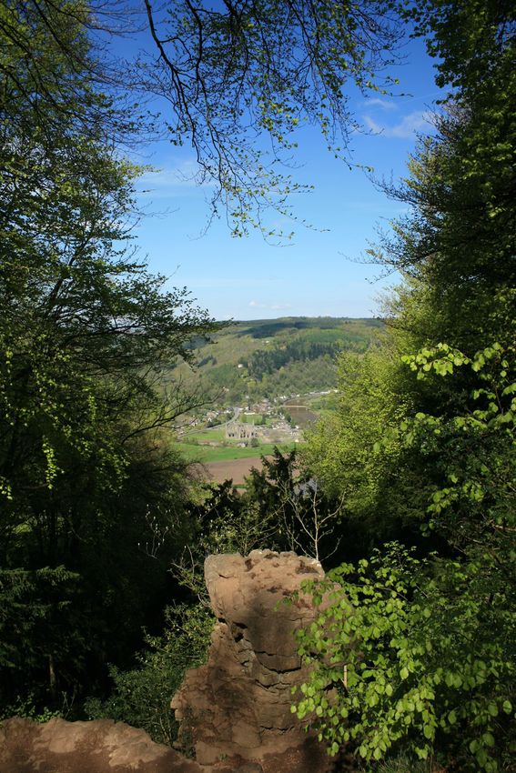
Contents
Part A: Purpose & Scope of the Appraisal                                            5
1      Introduction                                                                 5
2      Consultation                                                                 5
3      Planning Policy Context                                                      6
4      The Study Area                                                               8

Part B: Conservation Area Appraisal                                                 9
5      Location & Setting                                                           9
6      Historic Development & Archaeology                                          10
6.1    Historic Background                                                         10
6.2    Settlement Plan                                                             17
6.3    Key Historic Influences & Characteristics                                   18
6.4    Archaeological Potential                                                    18
7      Spatial Analysis                                                            19
7.1    Background                                                                  19
7.2    Overview                                                                    19
7.3    Character Areas                                                             21
       1. Tintern Parva                                                            21
       2. Riverside                                                                27
       3. Abbey Mill & Environs                                                    32
       4. Hillside / Valley Slopes                                                 36
       5. Angiddy Valley                                                           42
       6. Tintern Abbey & Environs                                                 45
7.4    Architectural & Historic Qualities of Buildings                             48
7.5    Activity: Prevailing & Former Uses                                          58
7.6    Contribution Made By Key Unlisted Buildings                                 59
7.7    Prevalent Local & Traditional Materials                                     60
8       Contribution Made by Green Spaces (Including Biodiversity Value),
                                                                                   62
Trees, Hedges & Natural Boundaries
9      Key Views                                                                   63
9.1    Landscape Setting                                                           63
9.2    Types of View & Their Relative Significance                                 63
10     Degree of Loss of Architectural and/or Historic Elements                    65

Part C: Management Proposals                                                       66
11     Boundary Revisions                                                          66
11.1   Overview                                                                    66
11.2   Areas for Inclusion                                                         66
11.3   Areas for Exclusion                                                         66

                                Tintern Conservation Area Appraisal & Management Proposals   2
12       Article 4 Directions                                                       68
    13       Proposals for Enhancement                                                  69

    Appendix 1:         Criteria for Buildings Making a Particular or Special
                                                                                        71
                        Positive Contribution
    Appendix 2:         Policies & Recommendations for New Development                  73
    Appendix 3:         General Criteria for Boundary Revision                          75
    Appendix 4:         Glossary                                                        77
    Appendix 5:         Bibliography & References                                       79
    Appendix 6:         Contacts                                                        80

    Part D: Conservation Area Appraisal Plans                                           81
    Plan 1       Tintern Conservation Area                                              82
    Plan 2       Historical Plan                                                        83
    Plan 3       Area of Archaeological Potential                                       84
    Plan 4       Spatial Analysis                                                       85
    Plan 5       Listed Buildings & Buildings Making a Particular or Special Positive
                                                                                        86
                 Contribution
    Plan 6       Character Areas                                                        87
                 Plan 6A Character Area 1 – Tintern Parva                               88
                 Plan 6B Character Area 2 – Riverside                                   89
                 Plan 6C Character Area 3 – Abbey Mill & Environs                       90
                 Plan 6D Character Area 4 – Hillside / Valley Slopes                    91
                 Plan 6C Character Area 3 – Angiddy Valley                              92
                 Plan 6D Character Area 4 – Tintern Abbey & Environs                    93
    Plan 7       Management Proposals                                                   94

3   Tintern Conservation Area Appraisal & Management Proposals
View from the Devil’s Pulpit, Tidenham
Part A: Purpose & Scope of the Appraisal
1 Introduction 2 Consultation
1.1 Conservation Areas comprise the 2.1 A consultation event was undertaken on
accumulation of an area’s positive architectural 9th November 2009 in Tintern
or historic attributes, rather than the quality of
its individual buildings, which makes it worthy 2.2 The purpose of this event was to obtain
of Conservation Area status. The attributes initial views from the local community on the
might include: the landscape setting of the strengths, weaknesses, opportunities and
area; the grouping of traditional buildings and threats to the Conservation Area.
the resultant spaces and sense of enclosure;
the scale, design, type and materials of the 2.3 Participants were broadly asked to
buildings; historic boundaries; public realm; consider the following:
landmarks, views and vistas; and the present
Positive characteristics (i.e. strengths) of
and former pattern of activities or land uses.
the Conservation Area that makes it
special
1.2 Tintern is one of 31 designated
Negative aspects (i.e. weaknesses) of the
Conservation Areas in the county of
Conservation Area that threaten its special
Monmouthshire. It was designated as a
character
Conservation Area on 12th January 1976.
Areas or features within the Conservation
Area that need to be improved or
1.3 The Tintern Conservation Area Appraisal
enhanced (i.e. opportunities within the
and Management Proposals is seen as the first
Conservation Area)
steps in a dynamic process. The overarching
Areas or features within the Conservation
aim is to preserve and enhance the character
Area under threat or at risk
and appearance of the Tintern Conservation
Whether the boundary of the Conservation
Area and to provide a basis for making
Area is correctly drawn
sustainable decisions about its future
The use of additional powers available to
management.
the Council’s Planning Department to
control alterations to original features on
1.4 Key study aims:
housing in the Conservation Area, such as
Identify those elements of Tintern which windows and doors (where this is not
contribute to its character already controlled)
Identify elements which detract from the
character 2.4 Feedback from this initial consultation has
Propose measures to maintain or improve been used by the study team in preparing the
the positive character, local distinctiveness Conservation Area Appraisal.
and sense of place of Tintern
1.5 The framework for the study follows
guidance set out in Circular 60/96: Planning
and the Historic Environment: Archaeology and
Circular 61/96: Planning and the Historic
Environment: Historic Buildings and
Conservation Areas and the latest draft
guidance from Cadw; Conservation Principles,
Policies and Guidance for the sustainable
management of the historic environment in
Wales, adopted March 2011.
5 Tintern Conservation Area Appraisal & Management Proposals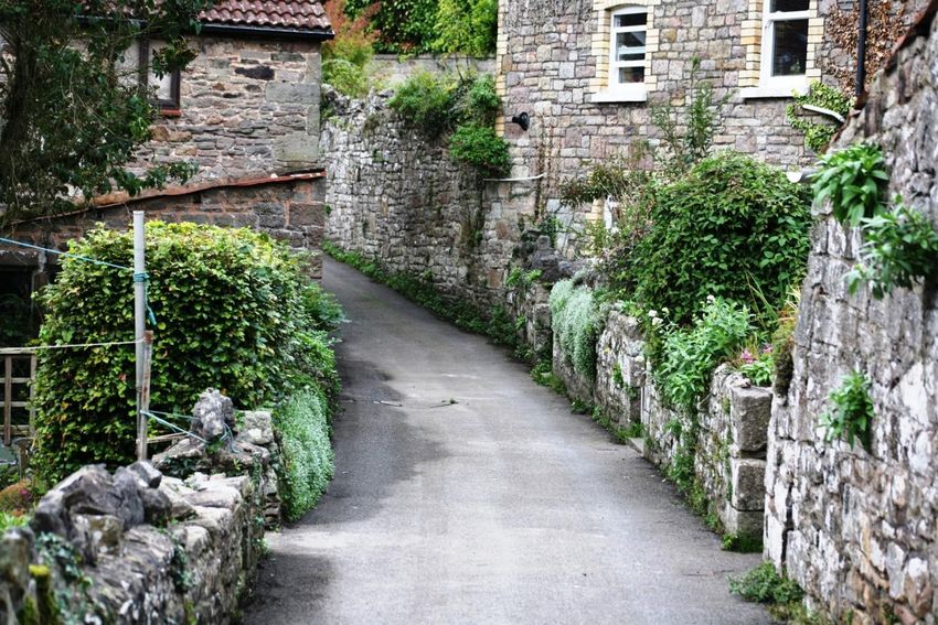
3 Planning Policy Context                            Development Plan (LDP) which was adopted

                                                                                                        Purpose & Scope of the Appraisal
                                                     on 27 February 2014, covering the period
3.1 Section 69 1(a) and 2 of the Planning            2011-2021. Strategic Policy S17 helps to meet
(Listed Buildings and Conservation Areas) Act        LDP objectives to protect and enhance the
1990 (‘the Act’) defines Conservation Areas as:      historic and built environment by ensuring
                                                     good design that enhances the character and
“Areas of special architectural and historic         identity of Monmouthshire’s settlements and
interest, the character or appearance of which it    respects     the   County’s     distinctiveness.
is desirable to preserve or enhance”                 Conservation Area Appraisals can play a
                                                     significant part in helping to meet such
3.2 In addition, the Act puts particular             aspirations. The historic environment chapter
emphasis on specific duties:                         is contained in pages 167-172 of the LDP.
                                                     Policies HE1, HE2 and HE3 directly relate to
“It shall be the duty of the local authority from    Conservation Areas.
time to time to review the past exercise of
functions under this section and to determine        3.7      The detailed criteria for assessing
whether any parts or any further parts of their      development proposals in Conservation Areas
area should be designated as Conservation            is set out in Policy HE1 and where appropriate
Areas…”                                              aims to ensure the findings of the
                                                     Conservation Area Appraisals are fully taken
3.3 This is reinforced by the guidance set out       into account when considering development
in Circular 60/96: Planning and the Historic         proposals. The Council will seek to preserve or
Environment: Archaeology and Circular 61/96:         enhance the special character or appearance
Planning and the Historic Environment: Historic      of Conservation Areas in the assessment of
Buildings and Conservation Areas. In particular,     Planning Applications. Policy HE2 relates
the local authority should from time to time,        specifically to the alterations of unlisted
formulate and publish proposals for the              buildings in Conservation Areas to ensure that
preservation and enhancement of these                the conversion, alteration and extension of
Conservation Areas (management proposals).           such buildings make a positive contribution to
                                                     Conservation Areas. A number of detailed
3.4    In order to undertake works of                criteria relating specifically to the design of
enhancement,     the   character      of  the        shop fronts in Conservation Areas are provided
Conservation Area needs to be clearly defined        in Policy HE3. Policy HE3 seeks to maintain
and understood (character appraisal).                high standards of shop front design in
                                                     Conservation Areas.
3.5      National planning policy is set out in
Planning Policy Wales (PPW). PPW provides            3.8     A number of additional studies carried
the overarching national strategic guidance          out to support the LDP should be read in
with regard to land use planning matters in          conjunction with the Conservation Area
Wales.     Conservation      of    the    historic   Appraisal. These include Landscape Capacity
environment is set out in Chapter 6 of PPW.          and Sensitivity Studies of the surroundings of
Policies relating to Listed Buildings, Scheduled     Monmouthshire’s towns and villages, including
Ancient Monuments, Archaeological Remains            those with Conservation Areas. Similarly,
and Historic Parks and Gardens are contained         published studies on Accessible Natural
in PPW unless locally distinct elements require      Greenspace and Habitat Connectivity may also
further Local Development Plan policies. PPW         include information that needs to be taken
also sets out clear statements for development       into account in preparing development
management in Conservation Areas.                    proposals in Conservation Areas. Relevant
                                                     information is also contained in the
3.6    This Conservation Area Appraisal              Monmouthshire        LANDMAP         landscape
should be read in the context of the                 character assessment.
Monmouthshire   County   Council Local

                                 Tintern Conservation Area Appraisal & Management Proposals                              6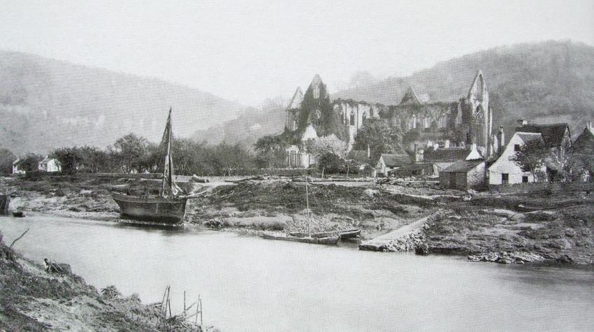
3.9      Draft      Green         Infrastructure
    Supplementary Planning Guidance (SPG) has          For Additional Information:
    also been produced. This provides practical        Monmouthshire Local Development Plan
    design and planning checklists along with          http://www.monmouthshire.gov.uk/planning
    good practice case studies. This SPG should be
    read in conjunction with the Conservation Area
    Appraisal.

7   Tintern Conservation Area Appraisal & Management Proposals
4 The Study Area

Fig.1 Study Area

                   Tintern Conservation Area Appraisal & Management Proposals   8
Part B: Conservation Area Appraisal
Purpose & Scope of the Appraisal
5 Location & Setting
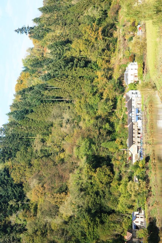
5.1 Tintern, approximately 7 miles north of 5.2 The village is set in a most picturesque
Chepstow, is situated on the west bank of the landscape, of national importance, recognised
River Wye valley. The village is effectively in its designation as an Area of Outstanding
divided into four distinct parts with the Abbey Natural Beauty. To the east, in the
to the south, the lower Angiddy valley to the Gloucestershire side of the valley (the river
west, Tintern Parva (Little Tintern) focused on forms both the county boundary and the
the riverside (above the river’s loop) to the boundary between England and Wales) is
north and development alongside the main Caswell Wood and ‘The Devil’s Pulpit’. To the
road through the village. (Fig.1 & Fig.2) west is the Angiddy valley and the wooded
slopes of Chapel Hill and Barbadoes Hill. To
the north is Barbadoes Green. The old railway
station that served Tintern, on the former Wye
Valley Railway, is situated some way out of the
village off the main road north.’
Refer to:
Part D - Plan 1 Conservation Area Plan
Fig.2 Tintern Location Plan
9 Tintern Conservation Area Appraisal & Management Proposals6 Historical Development & Archaeology
Fig.3 An early 20th century photograph of Tintern in its landscape setting
6.1 Historic Background Refer to:
Part D - Plan 2 Historical Plan
6.1.1 The hills around Tintern were settled in The settlement developed as a nucleated
the Bronze Age. Early Bronze Age round cairns cluster centred on the church. An early
are to be found in the forest at Barbadoes medieval wayside cross survives, although not
Green and late Bronze Age socketed axes have in situ (GGAT). There is a second early church,
been found on Chapel Hill. Iron Age Dobunnic first recorded in 955, at Penterry, 1.5km south-
coins have also been found in the Tintern area west of Tintern Abbey.
(Aldhouse-Green & Howell, 2004) and there is
an Iron Age promontory fort at the north end 6.1.3 In 1131 Tintern’s Cistercian abbey was
of Blackcliff Wood with a larger fort on Gaer founded by Walter fitz Richard of Clare, Anglo-
Hill, 2km south-west of the village. Norman Lord of Chepstow. The abbey, the
first Cistercian House in Wales and only the
6.1.2 In the 6th century the West Saxons second in the British Isles, was colonised by
started to make inroads into Gwent. In the monks from L’Aumône, France. The site was
‘Grant of King Meurig son of Tewdrig’ it is chosen for its remoteness, forests, meadows
recorded that a ‘battle’ took place at Tintern and rivers. For the next four centuries the
where King Tewdrig, having given up his abbey dominated Tintern’s development and
kingdom to his son, lived as a hermit among history.
the rocks of Tintern (Walters, 1992). By 765 a
church is recorded in the area now known as 6.1.4 Tintern stayed in the lordship of
Tintern Parva. The present building of St Chepstow, passing to William Marshal in 1189.
Michael and All Angels (Fig.4 next page) is first On the death of the last Marshal heir in 1245
mentioned in the Book of Llandaff in c.1348 the lordship of Chepstow and patronage of
(GGAT). Its irregular polygonal churchyard is Tintern passed to the Bigod family, earls of
indicative of an early ecclesiastical foundation. Norfolk. By the mid-13th century the Tintern
Tintern Conservation Area Appraisal & Management Proposals 10community had virtually completed extensive communal guest hall and the abbey itself
remodelling works of the abbey’s cloisters. In (Robinson, 2002).
1269 work began on the Gothic church
Conservation Area Appraisal
supported by Roger Bigod who had
undertaken the extensive re-building of
Chepstow Castle. The choir and presbytery
were available for use by 1288, but the church
was not consecrated until 1301. Further
improvements followed, including the
installation of an elaborate pulpitum in the
1320s. By the mid-14th century the major
building works, including a new abbot’s
residence had been completed (Robinson,
2002).
6.1.5 The church and cloisters sat within a
larger precinct which comprised a series of
walled enclosures and courts covering 27
acres, much of it enclosed by an outer wall.
Entry to the precinct was by at least two
gateways, one on the south-west side, the
other along the river frontage (its remains are
still visible alongside the Anchor Hotel). The
riverside gate led to a slipway, with a ferry
crossing giving access to the abbey’s
Gloucestershire estates (Fig.5). The abbey’s
outer court lay to the west and south and was
home to barns, stables, granaries and cow Fig.5 Tintern Abbey’s Watergate next to the
houses. Within the inner court there would Anchor Hotel
have been a high-status guest house, a
11 Tintern Conservation Area Appraisal & Management ProposalsConservation Area Appraisal
Fig.4 An early 20th century photograph of the view of St Michael and All Angels from the river
6.1.6 The monks and lay brothers farmed the to an abrupt end with King Henry VIII’s
surrounding landscape, practised non-ferrous dissolution of the monasteries. In September
metalworking, fished the river, and exploited 1536 the abbey was surrendered to the king
the woodlands. The abbey had extensive during the first round of suppression. In 1537
fisheries on the Wye and in 1330-34 there was the abbey buildings and lands were granted to
a dispute with river traders concerning the Henry Somerset, Earl of Worcester, who owned
weirs which were restricting the passage of both Chepstow and Raglan Castles. Valuables
river traffic to Monmouth, leaving the town were sent to the King’s treasury and other
and castle without supplies. The monks are items auctioned off. The destruction of the
also attributed with the erection of a series of buildings did not happen immediately; the
weirs along the Angiddy valley that powered lead from the roofs was not sold and melted
two grain mills and a fulling mill, with the down until the 1540s. The Earl of Worcester
pools above the weirs used as fish ponds. One leased out tenements and parcels of land in
of the mills was located on the Angiddy River, and around the buildings. Makeshift homes
outside the precinct wall. The abbey were constructed and the lesser buildings
transported goods up and down the river converted into cottages. The abbey and its
between Gloucestershire and Monmouthshire. estates remained in the ownership of the Earls
The settlement of Tintern developed around of Worcester, later becoming the Dukes of
the abbey precinct. Cottages were built up to Beaufort, until 1901 when it was purchased by
the walls and a community developed with the Crown (GGAT).
tenant-shopkeepers who set up stalls and
taverns. The abbey employed local servants, 6.1.8 Tintern’s fortunes as a secular
acted as a place of pilgrimage, supplied alms community led to expansion. Between 1568
to the poor and cared for pensioners who and 1631 the Society of Mineral and Battery
purchased the right to live at the abbey. Works established a number of ironworks
along the 2 mile long Angiddy valley for the
6.1.7 The abbey continued to prosper into the production of armaments. The first brass
16th century; a survey known as the Valor produced in Britain was made in Tintern in
Ecclesiasticus ranked it as the wealthiest abbey 1568. The production of brass for cannons and
in Wales. However the abbey’s existence came other armaments was soon abandoned but the
Tintern Conservation Area Appraisal & Management Proposals 12production of brass and iron wire continued 6.1.9 In addition to the wireworks industry,
and developed throughout the 17th century. cider making was another local trade, although
The valley became an important industrial small in comparison. A number of orchards
Conservation Area Appraisal
centre with a number of works including the were recorded in the tithe apportionment of
Tintern Upper Wireworks, the Lower 1844 and former cider houses survive today.
Wire/Ironworks which contained four water Unusually a number of these retain their
wheels, four hammers, and two annealing machinery still in situ, including within the
furnaces, and The Old Furnace blast furnace Anchor Hotel.
which operated from 1669. The iron/wire
industries largely ceased operation in the late
19th century. The Lower Wire/Ironworks was
converted into a tin-plating works in c.1880
(GGAT). Thirteen water-powered works have
been identified with eleven water-supply
ponds and dams (Newman, 2002) (Fig.6). This
industry utilised river transport with a wharf
built on the west bank of the Wye where flat
bottomed boats, known as trows, transported
iron ore to the furnaces and finished products
Fig.6 A water-supply pond next to the Royal
down to Chepstow and Bristol (Fig.7 next
George (now a car park)
page).
Fig.7 An early 20th century trow on the banks of the river at the Abbey’s Westgate
6.1.10 The monastic buildings at Tintern fell locking doors were hung on the West Front
into decay in the 16th and 17th centuries. The and iron gates positioned at other entrance
ruins held little interest until the rise of the points.
‘Picturesque’ movement in the late 18th
century. The Buck brothers were one of the 6.1.11 Tourism came early to the Wye Valley
first to depict the abbey ruins in an engraving as a direct result of the French Revolution and
of 1732. Charles Somerset, 4th Duke of Napoleonic Wars, which disrupted the ‘Grand
Beaufort initiated a process of consolidation of Tour’ favoured by the wealthy. After the
the ruins in the mid-18th century. Huge publication of William Gilpin’s guidebook,
13 Tintern Conservation Area Appraisal & Management ProposalsObservations on the River Wye in 1782, the 6.1.12 By the early 1800s the abbey had
‘Wye Tour’ attracted many visitors anxious to become a popular attraction. The Chepstow to
view the ‘Picturesque’ qualities of the Monmouth turnpike road of 1829 cut through
Conservation Area Appraisal
landscape in a two day trip along the river the medieval monastic precincts. It brought a
from Ross-on-Wye to Chepstow. Most new generation of tourists keen to explore the
travelled to see the ruins of the Cistercian ruins (Fig.9). Many were disappointed at the
Abbey at Tintern. Among the most famous abbey’s surroundings with ‘unpicturesque’
travellers and visitors of the abbey ruins were cottages and pigsties built around the ruins
artist J. M. W. Turner and poet William using stone from the medieval buildings
Wordsworth. Turner was early in his career (Robinson, 2002). By 1869 many of these
when he painted the ruins in c.1795 and as ‘hovels’ had been cleared away.
such the site has an important association with 6.1.13 In 1876, both the tourism trade and
the artist (Fig.8). local industry received a boost with the
completion of the Wye Valley Railway. The
line ran along the banks of the river crossing
over the Wye from the Tintern side at Llyn
Weir, running into a tunnel on the
Gloucestershire side and emerging on the east
bank of the river opposite the abbey (Fig.10).
Fig.8 Turner’s drawing: ‘Trancept, Tintern Abby’
by William Turner, c.1795 British Museum
Tintern Conservation Area Appraisal & Management Proposals 14Conservation Area Appraisal
Fig.9 Tourism brought hotels and guest houses such as the Beaufort Hotel
Fig.10 Tintern in the early 20th century looking over the village to the wireworks bridge
6.1.14 1901 saw the sale of the abbey and by a carpentry/wood turning business. In the
estates to the Crown. This initiated a new 1970s the complex was sold and converted
phase of development with the erection of a into a small complex of gift shops with a café,
number of ‘Crown cottages’ and other now Abbey Mills.
buildings (Fig.11). Speculative housing 6.1.15 Today Tintern still attracts tourists. It
continued to be built in the 20th century and retains a number of public houses and hotels,
tourism remained a mainstay of the area with supplemented by Bed and Breakfast-type
the Wye Valley Hotel opening in c.1920. The accommodation. Tourism has created a
Lower Wireworks, converted into a tinplate micro-economy which includes gift, book and
works in the 1880s, was converted into a antique shops and cafes. The abbey is open to
sawmill with a number of the buildings utilised the public and is now under the care of Cadw.
15 Tintern Conservation Area Appraisal & Management ProposalsConservation Area Appraisal
Fig.11 The Crown buildings including shops such as the General Supply Stores
Tintern Conservation Area Appraisal & Management Proposals 166.2 Settlement Plan Refer to:
Part D - Plan 2 Historical Plan
Conservation Area Appraisal
Fig.12 Tintern Parva in the early 20th century, entering the village from the north-east
6.2.1 Settlement within the Conservation Area sides and inter-mixed with the industrial sites
can be divided into four areas: the early although at Chapel Hill two historic routes
settlement at Tintern Parva to the north, the developed, one set further up the valley side
abbey environs, settlement along the Angiddy than the other, with houses developing
valley including Chapel Hill, and development alongside both lanes.
alongside the early 19th century turnpike road.
6.2.5 The arrival of the turnpike road along the
6.2.2 Tintern Parva developed as an early Wye Valley had a significant impact on the
ecclesiastical foundation with a church settlement, the road being driven through the
recorded in 765. A small irregular nucleated precinct of the abbey leaving remains of the
settlement grew up around the early church precinct wall detached from the abbey church
and a junction of routeways near the river and cloisters. Ribbon development alongside
(Fig.12). the turnpike took the form of houses, shops
and public houses within small plots at the
6.2.3 The southern part of the village is foot of the steep valley side. These linked the
dominated by the ruins of the abbey. Most of monastic area south of the mouth of the
the cottages and houses built within and Angiddy River to the early settlement core at
around the abbey have been removed Tintern Parva.
although a few secular buildings survive in the
area; their rather ad hoc appearance probably 6.2.6 The Crown’s ownership of Tintern in the
reflects their origins as piecemeal 20th century brought a collection of neo-
development with the ruins of the abbey. vernacular style cottages, Post Office, Police
Station and shops. Further infill and informal
6.2.4 Settlement along the Angiddy valley is dispersed groups of houses continued to be
typically linear, constrained by the steep valley built in the 20th century including an area of
17 Tintern Conservation Area Appraisal & Management Proposalssocial housing called Park Glade, north of
Tintern Parva on the road to Catbrook.
Conservation Area Appraisal
6.3 Key Historic Influences & 6.4 Archaeological Potential
Characteristics
6.4.1 The remains of the abbey and parts of its
6.3.1 The key historic influences and precinct, including sections of the precinct wall
characteristics of Tintern are: alongside the A466, are Scheduled Ancient
Monuments and so are regarded as being of
Early ecclesiastical centre at Tintern Parva, national importance. There is also a quarry on
developing as a nucleated settlement the hillside south of the abbey which is a
alongside the church; Scheduled Ancient Monument. Along the
12th century founding of Tintern Abbey lower part of the Angiddy valley the Lower or
with its walled precinct; Abbey Ironworks is a Scheduled Ancient
Cistercian development of agricultural Monument. Within these areas there will be a
estate and fishing and trade on the River presumption in favour of preservation of
Wye coupled with the exploitation of the archaeological remains in-situ. Advice from
Angiddy River in the Angiddy valley and Cadw and the Glamorgan-Gwent
the ancient woodland on the hills Archaeological Trust (GTAA), the council’s
overlooking the village; archaeological advisors, should be sought at
Dissolution of Tintern Abbey in 1536 an early stage in the formulation of
resulting in the partial destruction of the development proposals within or adjacent to
buildings in the 1540s; the scheduled areas.
16th century industrial development of
Angiddy valley with works extending into 6.4.2 In addition to the statutory designations
Tintern and development of river an Area of Archaeological Sensitivity has been
transport; identified. Within this area there is potential
Period of decline followed by the 18 th for the survival of archaeological remains
century development of the picturesque relating to the area of early settlement at
movement; Tintern Parva, the ribbon development
The scenic Wye Valley develops in the late alongside the turnpike road and the
18th century as a tourist attraction with the settlement and industrial activity along
‘Wye Tour’. The abbey draws tourists to Angiddy valley including the whole of the
Tintern, resulting in the development of Chapel Hill area of settlement. The areas
inns and early hotels and the removal of surrounding the scheduled areas of the abbey
houses that had been built within the not only form part of their important setting
precinct; but also have the potential to contain
The 1829 Chepstow to Monmouth archaeological remains. Additionally, the
turnpike road encouraged 19th century historic buildings of Tintern are an important
ribbon development; archaeological resource in their own right. Any
1876 opening of the Wye Valley Railway; proposed development within these areas
Late 19th century, early 20th century decline need to include appropriate measures to
in industry; assess and, if necessary, protect or record the
Construction of Crown cottages and other archaeological interest of the site or building.
buildings; Advice from the GGAT, should be sought at an
Tourism continues through the 20 th early stage in any proposed development
century to the present and is a major scheme.
contributor to the economy of the village. Refer to:
Part D - Plan 3 Area of Archaeological
Potential
Tintern Conservation Area Appraisal & Management Proposals 187 Spatial Analysis
Conservation Area Appraisal
7.1 Background 7.2 Overview
7.1.1 Conservation Areas are designated for 7.2.1 Tintern Conservation Area comprises six
their special character, but within the area distinct areas, namely; Tintern Parva, Tintern
there will be zones which are varied but Abbey, the riverside, the Abbey Mill and
contribute to the whole. It is important to environs, the Hillside and valley slopes and the
define these ‘character areas’ and provide a Angiddy valley.
clear understanding of the defining elements
making up the character of a particular part of 7.2.2 The overall character of the Tintern
the Conservation Area. This leads to a more Conservation Area is derived from its
useful and comprehensive document in distinctive riverside setting. It has a complex
development control terms. settlement pattern with the nucleated group of
buildings centred on the church of St Michael
7.1.2 Whilst individual character areas have at Tintern Parva, the linear ribbon
been defined with a line (see Plan 6), adjacent development along the A466 Chepstow to
areas will, in almost all cases, have a direct Monmouth Road, Tintern Abbey and its
effect on the character of any defined sub- environs and the valley hamlet on the Angiddy
area. Character areas do not sit in isolation River.
and when considering the impact of proposals
on the character and/or appearance of a 7.2.3 The deep, sweeping curve of the valley
Conservation Area the character area and of the River Wye plays an essential role in
adjacent character areas and their wider defining the character and appearance of the
setting (which may in some cases extend Conservation Area. The steep wooded valley
beyond the Conservation Area boundary) sides fall down to a gentler sloping, more
should be very carefully considered. There are open, tongue of land within the bend of the
often cases where character areas will overlap river. The loop of the river creates a narrow
giving these spaces added complexity and peninsular on the Gloucestershire side
importance in terms of proposed changes. enabling views of Tintern Parva from the
riverside at the Abbey and Abbey Mill.
7.1.3 It should be noted that whilst six
character areas have been identified, it is also 7.2.4 The historic village of Tintern Parva
important to appreciate the cohesion to the comprises two groups; the church, former mill
whole Conservation Area, which should always buildings, farmhouse and outbuildings on the
be considered when addressing the character riverside and a 19th century terrace of houses
of the Tintern Conservation Area. and 1920s Wye Valley Hotel situated on the
A466. Travelling south along the A466
7.1.4 For general guidance on the criteria used traditional 18th and 19th century stone cottages
for assessing buildings making a particularly are mixed with late 19th century villas with
positive contribution to the Conservation Area, ornate bargeboards, substantial hostelries and
please refer to Appendix 1. early 20th century Crown cottages and shops.
The magnificent ruins of the abbey church rise
Refer to: in the fields east of the A466 overlooking the
Part D - Plan 4 Spatial Analysis Wye and dominate the views and spaces on
Part D - Plan 5 Listed Buildings & Buildings travelling towards and past the ruins. A series
Making a Particular or Special Positive of cottage-scale houses are seen to the
Contribution hillsides to the west often partially obscured by
Part D - Plan 6 Character Areas the trees forming, in places, heavily wooded
slopes.
19 Tintern Conservation Area Appraisal & Management Proposals7.2.5 There is an interesting mix of building 7.3 Character Areas
types and materials reflecting the status of the
houses and cottages and the area’s local
Conservation Area Appraisal
7.3.1 Six distinct character areas have been
geology and past industry. The past industries identified in Tintern, the boundaries of which
of the area are represented in the stone walls, have been identified in Fig.13 below and Plan
streams, leats, culverts, mill buildings and 6. This section will identify the key attributes
machinery. of each character area.
7.2.6 From the hillsides surrounding Tintern 7.3.2 Each character area makes reference to
there are panoramic views of the River Wye as the following key considerations
it meanders along its course with the remains
of the Abbey church dominating these views. Form (cohesiveness – why is it a character
area)
Scale & Building Line
Significant buildings or groups of
buildings making a positive or special
contribution
Materials
Views
Local Features
Refer to: Significant Spaces & Gaps
Part D - Plan 6 Character Areas Trees, hedges and boundaries
Surfaces
Fig.13 Tintern Character Areas
Tintern Conservation Area Appraisal & Management Proposals 20CHARACTER AREA 1
Tintern Parva
Conservation Area Appraisal
Fig.14 View to Tintern Parva from the south, note its wooded valley setting opening to fields and a
vineyard beyond
7.3.3 This character area is a compact
community centred around the church on the
bank of the River Wye and includes the houses
either side of the A466. The area extends
northwards towards Catbrook and the Tintern
Pentecostal Chapel. To the north-east lies
Tintern Parva vineyard on the hillside. To the
east, across the Wye, are open fields; to the
west the A466 curves round entering Tintern
proper (Fig.14). The character area has two
distinct parts; the main road and junction with
Catbrook Road, a section strongly
Refer to:
characterised by the busy A466 and the far
Part D - Plan 6A
more intimate and enclosed area between the
main road and the riverside containing wall
lined lanes and footpaths around and leading
to and from the church. The latter is a quiet
and peaceful area with a very strong sense of
place.
7.3.4 The majority of houses within this
character area are of two storeys with three,
three-storey terraced houses on the south side
of the A466 (Wyeborne, Redborne, Wyeview)
(Fig.15). Building lines are generally offset to
Fig.15 Wyeborne and Redborne; terraced houses
the road, with most houses taking advantage
of a south-facing aspect. Detached houses are
21 Tintern Conservation Area Appraisal & Management Proposalsscattered on the hillside leading up to the
vineyard, which is orientated south looking
across to the river. A stone wall on the south
Conservation Area Appraisal
side of the unmade road leading to the
vineyard provides some enclosure. Off from
the main road to the riverside, buildings and
walls define the narrow access roads to the
church and church car park (Fig.16). The
intimacy and comfortable enclosure to this
part of the Conservation Area, by either
boundary walls or houses is an important and
strongly defining element of this small but
distinctive part of the Conservation Area. At
the east end of Tintern Parva houses are set
back from the roadside including the modern
Parva Barns Cottage and converted Parva
Barns (set behind an incongruous drive
entrance) (Fig.17). The junction adjacent to Fig.17 The converted Parva Barns
the Wye Valley Hotel is a key transitional point
in the townscape, where the road sharply
curves and is strongly defined by a high stone
wall, topped with a laurel hedge, to the
Hospice on Trellech Road.
Fig.16 A narrow road bound by stone walls leads down to the church. Strongly defined narrow lanes and
access roads are a characteristic of this part of the Conservation Area.
Tintern Conservation Area Appraisal & Management Proposals 227.3.5 Groups of buildings which make a appearance of this part of the Conservation
positive contribution towards the character Area
and appearance of this part of the
Conservation Area Appraisal
Conservation Area include the Wye Valley
Hotel, the stone-built Hospice set on a bank to
the west and its stone boundary wall to the
roadside, and the short terrace of houses to
the south side of the A466. A further
significant group comprises the church (with
lychgate, church gates and wall), and Parva
Farmhouse Cottage with its ecclesiastical-style
stone windows on its south gable. To the
north, lining Catbrook Road, there is an
attractive group of buildings; Japonica
Cottage, an outbuilding to the side of the
stream on the west side of the road, Orchards
House, Rockleigh and Rose Cottage (Fig.18).
Their varied roof forms seen against a
backdrop of trees, use of traditional materials
and low stone boundary walls, make a strong
contribution to the quality of the streetscape
in this part of the Conservation Area. On the
east side of the A466 is Ty Awen and on the
west side The Manor House (a stone villa with
veranda and dagger boarding (Fig.19) with
well-crafted iron entrance gate), both making a
positive contribution to the character and
Fig.19 The Manor House
Fig.18 Orchard House, Rocklea & Rose Cottage: An attractive and varied group making a positive
contribution to the Conservation Area notwithstanding out of character alterations to windows.
23 Tintern Conservation Area Appraisal & Management Proposals7.3.6 There is a good range of traditional
building materials in this small character area.
Buildings are generally constructed of coursed
Conservation Area Appraisal
rubble stone, sometimes with dressed stone
quoins (Fig.20). The short terrace of houses
on the south side of the A466 is constructed of
dressed stone. There are red brick dressings to
window and door openings. Chimney stacks
are constructed of stone or red brick or
rendered. Boundary walls are often quartz
conglomerate or a mixture of local limestone
and sandstone and are perhaps the best
examples of what could be considered as the
local vernacular materials. The early 20th
century Wye Valley Hotel exhibits a competent
mix of materials from this period including tile
pressing, render, red brick and clay tiled roof
(Fig.21). There is a good survival of clay
Fig.20 The distinctive local rubblestone with
pantile roofs, but some have been replaced building alterations highlighted in varied pinker
with concrete interlocking tiles and modern shade of stone
pantiles. Gable roofs are usually finished with
timber barge-boards, occasionally decorative
(the cottage adjoining the Wye Valley Hotel).
There are some good examples of timber
casement windows, with some particularly fine
small leaded casements to the first floor of
Rose Cottage and timber sashes to Japonica
Cottage. Unusual examples include metal
barred windows either side of the entrance
door in Orchards House. There is a good
survival of a stone mullion window in the stone
lean-to attached to Fryers’ Row (Fig.22). Fig.22 An historic stone mullion window in the
lean-to attached to Fryers’ Row
Fig.21 The Wye Valley Hotel (circa 1920) displaying a good and varied mix of materials reflecting the
trends of the architectural period
Tintern Conservation Area Appraisal & Management Proposals 247.3.7 Entering the village from the east the
church is partially screened by a thick conifer
hedge. The compact churchyard, enclosed by
Conservation Area Appraisal
trees, is a significant open space with public
access and forms an important setting to the
Grade II listed church. By the church there are
glimpsed views between the houses east
towards the river. At the church car park there
are important views looking south towards the
linear development of Tintern and the Crown
buildings (now Stella Books) alongside the
A466. These views are characterised by the
wooded valley sides that come down on to the
roadside directly behind the houses with no
other development in sight. There are views
south and east across the river to
Gloucestershire dominated by the green hills
and dense woodland which characterises the
valley sides for much of the wider setting to
the Conservation Area. To the west, the
heavily wooded slopes of Chapel Hill and
Barbadoes Hill curve around providing a
dramatic backdrop to the settlement (Fig.23).
North of the centre on the east side of Trellech
Road, there are two small paddocks of rough
pastureland, high above the roadside.
Fig.23 Mixed conifer and deciduous woodland adds to the picturesque qualities of the setting of the
village
25 Tintern Conservation Area Appraisal & Management Proposals7.3.8 The stone walls and water courses are a
key local feature of this part of the
Conservation Area. A culvert takes the Cat
Conservation Area Appraisal
brook under the A466, emerging at a well,
accessed down stone steps and concealed by
high stone walls. A leat runs alongside the
well taking the water under Fryers’ Row,
emerging alongside its east elevation, flowing
south towards the River Wye. Some stone
walls are topped with the distinctive limestone
that has been dissolved by carbonic acid,
which is a particular feature of this area, being
also found at St Arvans and Llandogo (Fig.24).
The high stone wall to the Hospice contains a
fine arched doorway containing a timber door
with ornate strap hinges. There is also a good
survival of stone kerbstones either side of the
A466. Iron railings to the front of Wyeborne
Terrace define public/private space and are a
good historic survival significantly contributing
towards the character and appearance of this
part of the Conservation Area. Fig.24 Unusual capping stones of dissolved
limestone are a distinctive local feature
Tintern Conservation Area Appraisal & Management Proposals 26CHARACTER AREA 2 7.3.9 This character area is strongly defined by
Riverside the loop of the River Wye which the road
follows, and the steep valley sides. The
Conservation Area Appraisal
majority of the houses are located on the west
side of the A466, confined to the roadside by
the dramatic wooded slopes rising above
them. The area has the character of a
distinctive riverside settlement looking south
and east towards and across the river. The
substantial stone retaining wall on the west
side of the A466 is a distinctive feature
throughout the character area. The wall, tall in
the north part of the character area, gradually
reduces in height as it travels south. (Parts of
the wall have been rebuilt and the hill slopes
Refer to: terraced following a recent landslide). Above
Part D - Plan 6B the wall are areas of scrubland and brambles
above which rise the wooded slopes of
conifers.
7.3.10 The scale and building line varies within
the character area. Buildings are mainly two-
storey, with occasional two and a half storey,
with a varied roofline (for example, the Coach
House which is equivalent to three-storey)
which adds to and enlivens the streetscene
when viewed on travelling along the riverside.
Houses are either right on the roadside, their
plots cut into the hillside behind (Holmleigh is
dug into the slope, with the Coach House
south wall partially formed by the cliff) (Fig.25)
or otherwise raised from the roadside on
platforms carved out of the hillside with steep
small terraced gardens and outbuildings above
the roadside. Most, if not all, face east or
south-east (depending on their location on the
curvature of the river) looking towards and
across the river. Tintern Garage, housed in a
former industrial building, is one of the few
buildings positioned on the east side of the
A466 (Fig.26 next page). Enclosure created by
the tall retaining wall on the west side of the
A466 is not mirrored on the east side. This side
is bounded by a mixture of overgrown
Fig.25 Some houses due to limited space for built vegetation, trees, car parking, picnic benches
form are set into the valley sides, a distinct and seating serving the Rose & Crown public
feature of this part of the Conservation Area house. There are stretches of galvanised steel
railings on the road side and on the riverside
where there are tall walls (from river level)
dropping away to the water. The road narrows
at The Falls with Riverside Cottage opposite.
27 Tintern Conservation Area Appraisal & Management ProposalsFig.26 View south to the pinch point created by Tintern Garage on the east side of the road
7.3.11 There are several groups of buildings           7.3.12 Common to other parts of the
                              which make a positive contribution towards             Conservation Area, there is a varied range of
                              the character and appearance of the                    building materials. The roof coverings are
Conservation Area Appraisal

                              Conservation Area. These include the Old               occasionally natural slate (to Stella Books, The
                              Rectory B&B, the Coach House (with distinctive         Old Bakehouse and Tanglewood) or clay
                              oriel window), and Holmleigh which has                 pantile. Some buildings have replacement
                              decorative finials to the ends of barge-boards         concrete interlocking tile roofs, but this change
                              and vertical timber sliding horned sash                could be reversed. The older buildings are
                              windows with corner flower motif. There is an          constructed of the local limestone, quartz
                              attractive stone cottage (Spring Cottage) set          conglomerate or sandstone.
                              back above the roadside, two doors south of
                              the Moon and Sixpence, with wooden                     7.3.13 White or cream painted render is a
                              casement windows under stone arched lintels            characteristic of buildings in this area with
                              and short red brick chimney stacks. A small            occasional cottages in exposed stone, or in the
                              stone outbuilding with clay pantile roof               case of Crown buildings, half-timbering. Wye
                              survives in a poor state of repair in the garden       Lodge, a well-conceived modern building, is
                              to the south (Fig.27). A further group of              timber-clad with multiple and varied window
                              buildings comprises the adjoining Crown-built          openings (see Fig.72 in Section 7.4). The Old
                              Tanglewood with decorative barge-boards and            Rectory House has a natural slate roof, white
                              canted first floor window, the former Crown-           painted render with half-timbered gable and
                              built shop, now Stella Books, with central ox-         Georgian style fanlight above the main door.
                              eye window and ashlar dressings, Stella Books          Some buildings retain their original timber
                              entrance, half-timbered at first floor level and       windows, for example, the first floor vertical
                              the Old Bakehouse (Tintern Antiques), a long           sliding sashes of the Rose and Crown which
                              stone range with rusticated stone lintels and          make a significant positive contribution to the
                              central carriageway arch. Further south is             character and appearance of this building.
                              Wyedene, a rock-faced and half-timbered (at
                              first floor) Crown Cottage of 1911 in the same
                              style as the other Crown Cottages within this
                              group (Fig.28).

                              Fig.27 Spring Cottage set up above the road in a commanding position with stone outbuilding

   29                         Tintern Conservation Area Appraisal & Management Proposals
Fig.28 View to the riverside Crown houses and shops built at the foot of the wooded hill
7.3.14 The key to understanding the character            coming into view the further south one travels
                              of views to this part of the Conservation Area           along the riverside.
                              is the appreciation of the pronounced curve to
Conservation Area Appraisal

                              the Wye River and how the road and                       7.3.15 Features of local note include the tall
                              development follows this curve, enabling                 stone retaining wall on the west side of the
                              developing and diminishing views to various              A466 (with blocked openings and gateways)
                              landmarks or allowing vistas to the landscape            and the remains of stone walls high above
                              beyond. There are a series of developing                 houses on the lower slopes of the hillside, for
                              views east and north towards and across the              example, behind the Moon and Sixpence. In
                              river from within the character area. This               some places, for example, at The Falls, the
                              includes; views to the west front of St Michael’s        stones used for these walls are particularly
                              Church glimpsed between conifer trees; wide,             large. Prospect Cottage has a fine stone
                              open views in areas of car parking and other             arched doorway. Other features include
                              public areas on the east side of the road which          watercourses running down behind the
                              take in the closely grouped traditional                  retaining wall, some with basins, which then
                              buildings which make up the settlement of                run in culverts under the A466, such as the
                              Tintern Parva to the north-east, and the open            watercourse next to Wye Lodge. There are
                              countryside across the river. In views across            good survivals of iron railings in places
                              the river, a group of farm buildings is                  including those to Prospect Cottage, and fine
                              prominent in the landscape comprising Dutch              hooped railings to Melrose House. Other
                              barn, stone field barn and cow shelter                   features include stone gate piers to Wesley
                              arranged in a walled courtyard (Fig.29). On              Cottage and Melrose House, stone kerbs to
                              travelling south from Tintern Parva through              the A466, and a selection of canted and bow
                              the character area, the former tramway bridge            windows to properties on the west side of the
                              (Wireworks Bridge) is a prominent feature in             road.
                              views looking south with the abbey itself

                              Fig.29 Farm buildings on the Gloucestershire side of the Wye (outside the Conservation Area) with the
                              Tintern Parva vineyard beyond

   31                         Tintern Conservation Area Appraisal & Management Proposals
CHARACTER AREA 3 collection of houses at the road to Devauden
Abbey Mill & Environs on the west side of the A466. The car park of
the Royal George was once a holding pond for
Conservation Area Appraisal
Abbey Mill. The enclosure of the southern side
of the Riverside character area (character area
2) is lost upon entering character area 3 as the
road opens out at the Abbey Mill. This section
forms a transitional zone between the riverside
area and Tintern Abbey.
7.3.17 Houses are of a similar scale, mostly
two-storey, interspersed with larger, grander
buildings such as the Royal George Hotel. The
Abbey Mill comprises a complex of converted
industrial buildings both single-storey and
Refer to: two-storey, with a modern timber shop and
Part D - Plan 6C tourist information point. Ashweir Court, a
large, substantially re-built, red brick workshop
with slate roof is located on the riverside,
north of the bridge. A road, south of the
Abbey Mill, leads between the doctor’s surgery
and hall to the riverside emerging as a path at
the Anchor Hotel. Houses are generally offset
along the roadside. To the north the modern
Nos.1-4 Quayside face the river while Nos. 1
and 2 Lower Leytons are set back slightly from
the roadside, gable end onto the road.
Travelling east Nos. 1 and 2 Quayside Cottages
Fig.30 Prominently sited former Police Station are located right on the roadside facing north.
Quay House maintains the building line and as
the road turns the corner along the riverside
Wye barn faces the river to the north-east.
7.3.18 The Abbey Mill complex is a distinctive
group of historic former industrial buildings,
now converted into craft and gift shops with a
café set in an area of hard landscaping with car
park to the north-east. There is a pond within
the complex and a recently restored
waterwheel. Above the Abbey Mill on the east
side of the A466 is a group of Crown buildings
Fig.31 The Royal George: a landmark corner
including the former Police Station of 1910
building of historic and architectural interest (Fig.30). On the west side of the A466 is an
and forming an important group with Crown excellent and diverse group of buildings
Lodge and Walnut Tree Cottage dominated by The Royal George Hotel
positioned at The Cross, the junction of the
A466 and Forge Road. The Royal George
7.3.16 This character area is focused on the
originated in the late 16th century but was
Abbey Mill complex to the side of the A466,
substantially rebuilt in the 18th, becoming a
extending down to the former Methodist
hotel in 1835 and altered again in the 20 th
Chapel, including the former tramway bridge
century (Fig.31 & see Fig.57). To the north-
crossing the river to the Gloucestershire side,
west, across the Angiddy River is an attractive
together with the Royal George Hotel and
Tintern Conservation Area Appraisal & Management Proposals 32vernacular stone cottage (The Bay, Fig.32), a
relatively rare survival in Tintern, and to the
south-west is the double pile, three-storey
Conservation Area Appraisal
Crown Lodge with Walnut Tree Cottage and
associated stone outbuilding immediately to
the south on the bank overlooking the road
below. This group is important as a historic
survival of significant buildings with a varied
but complementary palette of materials and
varied building scale.
7.3.19 Buildings are constructed of coursed
limestone or sandstone rubble, sometimes
rendered and painted white (for example,
Crown Lodge). Other buildings, including the
Police Station, are dressed stone. Architectural
detailing includes red brick window dressings
and red brick chimney stacks. Roof coverings
are a mix of red clay pantiles to the Crown
buildings, The Bay and Abbey Mill complex,
natural slate to Crown Lodge, and the former
Methodist Chapel, and the distinctive green Fig.33 A well executed traditionally laid roof of
Westmorland slates in diminishing courses to diminishing slates at the Royal George Hotel
the Royal George Hotel (Fig.33).
Fig.32 The Bay: attractive and largely unaltered vernacular stone cottage, presently unoccupied and as
such a vulnerable heritage asset within the Conservation Area
33 Tintern Conservation Area Appraisal & Management Proposals7.3.20 Fine landscape views are to be had
from the 1870s former tramway bridge
(Fig.34). To the west, The Rock stands out on
Conservation Area Appraisal
the lower slopes of the hillside. From outside
The Royal George views to the south-east
along the curving A466 are terminated by the
ruined abbey church set against the backdrop
of the wooded river cliffs. On the riverside
there are views north-east to the tramway
bridge (Fig.35).
Fig.34 The settlement pattern and its relationship to the landscape can be appreciated in views from the
tramway bridge
Fig.35 View to the iron tramway bridge (also known as Wireworks Bridge), a positive reminder of Tintern’s
past industrial history
Tintern Conservation Area Appraisal & Management Proposals 347.3.21 The watercourses are an important
feature, including the weir on the west side of
the A466 that runs under the road leading
Conservation Area Appraisal
down to the Abbey Mill complex. The water
can be channelled by a series of sluices to the
restored waterwheel (some of the mill
machinery survives within the Abbey Mill
shop). The sound of the channelled water is an
ever-present aural aspect of the area’s
character. Other features of local note include
the railings to Crown Lodge and wrought iron
overthrow supported on stone piers to the
former Methodist Chapel (Fig.36).
Fig.36 The simple iron gateway arch to the former Methodist Chapel
35 Tintern Conservation Area Appraisal & Management ProposalsCHARACTER AREA 4 nearby Llandogo hillside. The hillside is
Hillside / Valley Slopes covered with conifer plantations and mixed
woodland which includes yew and oak.
Conservation Area Appraisal
7.3.24 Where found, the houses are a variety
of building types from stone cottages to
Crown houses and modern bungalows. The
houses built into the hillside are predominantly
two-storey with a small number of bungalows.
Most individual houses sit within small plots in
a relatively random distribution but often
related to topography and proximity to
watercourses (for powering mills) and other
areas of former industrial activity. Due to the
nature of the gradient, buildings do not share
Refer to: a common building line. The majority face
Part D - Plan 6D north-east looking across the Wye valley from
their elevated positions to the river and
7.3.22 This character area makes up the beyond. Terraced gardens and small
largest part of the Conservation Area but it has outbuildings are common characteristics of
a low density of buildings, having isolated these plots. A group of houses is positioned
hillside cottages set amongst the trees. The on the south-west side of the A466 on a bank
area covers the slopes of Barbadoes Hill on the overlooking the road and Abbey. The houses
north side of the Angiddy valley and Butcher’s can be accessed via a lane leading from
Hill and Chapel Hill to the south. It is bounded Tintern Cross, travelling behind the houses,
by the A466 and houses on the lower slopes to and re-emerging on the A466 between Tintern
the east. The woodland provides seclusion House and St Anne’s House. This group has, in
and quiet, with birdsong taking the place of contrast to the hillside houses, a strong
traffic noise from the A466 adding to the sense building line created by the stone wall facing
of rural isolation in places.’ the lane to the rear of these buildings.
Notably, a dilapidated stone structure on the
7.3.23 The Tintern Trail (a walking route) takes opposite side of the lane is recorded as a
the visitor up sunken winding lanes with Pound on the first edition ordnance survey
stretches of stone paved paths with earth map (Fig.37).
banks, hedges and drystone walls with ferns,
ivy and other vegetation, reminiscent of the
Tintern Conservation Area Appraisal & Management Proposals 36You can also read