Arrecife-Lanzarote-Spain Page 1 of 23
←
→
Page content transcription
If your browser does not render page correctly, please read the page content below
Arrecife-Lanzarote-Spain Page 1 of 23 © Copyright www.TomsPortGuides.com
Toms Arrecife, Lanzarote Spanish Canary Island Cruise Port Guide 2019
1) Where ships dock 2) Maps for a Step-by-Step Arrecife Walking Tour, 3) Timanfaya Volcanic
Park, 4) Camel Rides on the Sand Dunes, 5) Cesar Manrique Foundation multi-level home built
into five volcanic bubbles, 6) Haria – the lush green valley where artists and craftsmen live,
7) Jameos del Agua volcanic cavern with tunnels and a lake, 8) Mirador del Rio observation
platform for spectacular views from a mountain top at the northern end of the island.
    There are 7 major Spanish Canary Islands of volcanic origin in the North Atlantic, west of Africa.

Why Visit and Vacation in the Spanish Canary Islands?
    • Each island offers unique opportunities for outdoor activities. Hiking is popular. Trails lead to
        spectacular settings. Organized tours and car rental are available to explore and photograph the rugged
        mountains, volcanoes, forests, rock formations, national parks, villages, coastline, beaches, and more!
    • Each island has its own history and state of development. Some are rural and undeveloped with small
        towns, farming, vineyards, and old fishing villages along the coast. Other islands are more developed
        with larger towns and villages, abundant shops, hotels, resorts, and night life.
    • Over hundreds of thousands of years, each island evolved in geographical isolation. Hence, each island
        has unique, rare plant and animal life in its ecosystem.
    • Each island has its own micro-climate. Some have lush vegetation. Others have dry, barren landscapes
        with volcanic rock formations and lava flows described as “moonscapes”. Rainfall in the western
        Canary Islands is influenced by proximity to the Atlantic Ocean Gulf Stream. These islands have tracts
        of forest and lush vegetation. The north of Tenerife has many plant species, while the south is an arid
        desert. The eastern islands of Lanzarote and Fuerteventura are deserts ~ 65-70 miles west of Africa.
The tough decision is which island to visit. If you have the time, visit all seven of them. All the islands are
accessible by ferry boats, most have airports, and many are visited by cruise ships.
Lanzarote Island is a desert with a comfortable, dry, warm climate. The barren landscape of volcanoes, and
lava flows are described as a “moonscapes”.

This Expedia YouTubeVideo is very informative and can be very helpful when you are planning shore
excursions for your cruise to Lanzarote. I highly recommend it.
  https://www.youtube.com/watch?v=JHWlSrIgwwE

Arrecife-Lanzarote-Spain                        Page 2 of 23               © Copyright www.TomsPortGuides.com
GPS Coordinates
I provide GPS coordinates for important locations that can be used with Microsoft or Google maps and GPS
enabled devices. The GPS format is Degrees, Minutes, and Seconds ddd° mm' ss.ss” N ddd° mm' ss.ss” E.
Copy and paste GPS coordinates from this guide into Google or Microsoft Bing maps
Or type GPS coordinate numbers and periods into the map search box replacing the symbols for degrees,
minutes, and seconds with spaces.
For the cruise ship dock at Puerto Los Marmoles GPS = 28°58'11.9"N 13°31'35.2"W
        Copy & Paste 28°58'11.9"N 13°31'35.2"W from this guide into Google maps and press “enter key”
        Or Type 28 58 11.9 N 13 31 35.2 W into Google maps and press “enter key” to find the port
        Google places a down-pointing red arrow at the GPS location.
For information on how to use GPS coordinates, see my web-pages:
https://www.tomsportguides.com/map-user-guide.html how to use GPS coordinates with Google or Bing maps
https://www.tomsportguides.com/world-gps-maps.html how to use GPS coordinates with electronic devices
such as tablets, phones, and GPS hand held or vehicle installed devices.
                                                 Table of Contents
                         Subject                                                                                Pages
Map of Lanzarote Island showing 13 popular tourist sites                                                             4
Overview map of Arrecife showing the two cruise ship dock areas and center city tourist sites.                       5
Travel options from your cruise ship to center city Arrecife by walking, shuttle bus, or taxi.                       6
Walking tour of Arrrecife: Playa del Reducto Beach, Gran Hotel & Spa, Parque Isas Canarias                           7
Map of Arrecife popular tourist sites between Gran Hotel & Spa and Charco de San Gines (the Lagoon)                  8
Center City sites: Tourist Info Center, Cultural Center, Castillo de San Gabriel, La Casa Amarilla History Museum 9
Center City sites: Plaza de la Constitution, Archaeological Museum                                                  10
Google street map showing shops, cafes, restaurants, banks, etc. in the main shopping area                          11
The Old Market “La Recova Antiguo Mercado” is next to St Gines Catholic Church                                      12
Cafes and restaurants around the lagoon, Charco de San Gines                                                        13
Castillo de San Jose Art Museum, Lanzarote Airport, Puerto del Carmen, Bodega la Geria vineyard                     14
Timanfaya Volcanic Park Visitor Center,                                                                             15
Photos of the volcanoes from a bus tour through the park                                                         16-17
An aerial map of the volcanic park                                                                                  18
Camel rides on the sand dunes                                                                                       19
Playa del Janubia black beach – the waves and undertow prevent swimming, some use it as a nude beach,               20
Cesar Manrique Foundation is a gorgeous multi-level artist’s home built into five volcanic “bubbles.”               20
Famara Cliffs have hiking trails along the mountains for spectacular views of the northwest side of the island      21
Haria has fertile soil and humidity for lush grown of palm trees and flowers. It’s the artist/craftsman center.     21
Jameos del Agua is a volcanic cavern with tunnels and a lake that has been transformed by the artist, Cesar         22
Manrique, into a beautiful site with a garden entrance, a 600 seat auditorium for concerts, a pool, and a bar.      22
Mirador del Rio is an observation platform and cafe with outstanding views from the north end of the island.        22
User Feedback, Copyright Notice, Terms and Conditions for use of Toms Port Guides                                   23

CAVEAT
Information contained herein is believed to be accurate. PLEASE verify the information you use for your travel
plans. Opinions expressed are my own. This port guide is protected by copyright law - see the last page of this
guide for legal notices.
Tom Sheridan

Arrecife-Lanzarote-Spain                           Page 3 of 23                © Copyright www.TomsPortGuides.com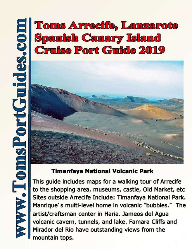
Here’s a brief description of sites highlighted on this map:
1) Docks for cruise ships, cargo, and ferry boats, 2) Arrecife center city, 3) Airport, 4) Puerto Del Carmen is a
resort town with beautiful beaches, shopping, restaurants, casinos, etc. 5) Bodega la Geria is a vineyard.
6) Visitor Center for the 12,600 acre Timanfaya National Park with dormant volcanoes and lava flows.
7) Parking lot for Camel rides on the sand dunes, 8) Playa Janubia is a long, black sand beach near the salt flats.
It’s unsafe for swimming due to waves and undertow. Some use it as a nude beach. 9) Cesar Manrique
Foundation - the artist's house/studio built around volcanic bubbles. 10) Hiking trails for views of Famara Cliff.
11) Haria has a micro-climate of high humidity for growth of palm trees and flowers in a lush green valley on
this desert island! 11) Jameos del Agua is a 4-mile long volcanic tunnel for hiking. 12) Mirador del Rio viewing
platform on a cafe with breathtaking views from the mountain top to the sea and islands north of Lanzarote.

Arrecife-Lanzarote-Spain                         Page 4 of 23                © Copyright www.TomsPortGuides.com
Arrecife-Lanzarote-Spain Page 5 of 23 © Copyright www.TomsPortGuides.com
Details for map on page 5
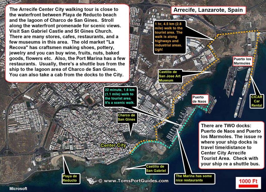
The Port of Arrecife, Lanzarote is also know as Los Marmoles Port. Arrecife (pronounced air ci fer) is the
capital city of Lanzarote. There are two dock areas called Puerto Los Marmoles and Puerto de Naos. Cruise
ships can use either dock. Depending on the number of cargo, container ships, and ferries in port, there can be
room for about four cruise ships.
If your ship is docked at Puerto Los Marmoles GPS = 28°58'11.9"N 13°31'35.2"W it’s a one hour, 4.5 km
(2.8 mile) walk along highways to Arrecife center city shown by the dashed orange line on the map. Ugh.
There are three convenient options to travel from the ship at Puerto Los Marmoles to Arrecife:
1. Usually there’s a shuttle bus from the ship to Charco de San Gines, a lagoon with several shops and
restaurants along the north side of the lagoon.
2. You can rent a car from CICAR Car Rental at Puerto Los Marmoles dock https://www.cicar.com/en
3. Take a taxi. To estimate taxi fares, see
https://www.lanzarotetaxi.com/en/formulario_traslados_lanzarote_taxi.php
On the web-page, set the language to English at the top of the page.
You have to fill in three boxes to see the taxi fare:
1) Set DEPARTURE FROM Arrecife Port (Los Marmoles).
2) Set DESTINATION to any place you wish to visit such as
Arrecife (City).
3) Transfer Date (Outbound) Select a date from the calendar. You
don’t need to fill in any other information.
The fare is different for a weekday, weekend, or holiday. The fare
for 1-4 people in a taxi is ~ 17 euros from the port to center city.
Use this as a reference; you might find a better fare.
If your ship is docked at Puerto de Naos GPS = 28°57'57.7"N 13°32'00.6"W shown on the map on page 4.
It’s a 22 minute, 1.8 Km (1.1 mile) walk past the marina, to the tourist area in Arrecife.
Convenient options to travel from Puerto Los Marmoles dock to Arrecife:
1. Walk from your ship as shown by the dashed blue-green line along the scenic marina to the harbor and
to the boardwalk in Arrecife tourist area.
2. Another option is to take a shuttle from the ship to to the lagoon Charco de San Gines.
Planning your walking tour of Arrecife.
The most popular area tourist area is the site of the former “fishing town”, now known as “Center City.” People
who are vacationing in Arrecife, begin their walking tour at Playa Reducto Beach near the resort hotels. People
who are on Cruise ships usually begin their walking tour at “Charco de San Gines”. Regardless of where you
start your tour, you can visit 11 sites, labeled as A thru K on my maps on the next two pages.
How Much Time Do You Need For A Walking Tour ?
To visit most of the sites, you’ll need 4 to 5 hours. Plan on 30-45 minutes at La Cassa Amarilla History
Museum, the Archaeological Museum, San Gabriel Castle, and the Old Market. Plus you’ll need time for
shopping and a stop at a cafe for coffee of lunch. There’s a lot to see and do!
To minimize walking time, you might take a cab from the port to the furthest tourist site you wish to visit in the
city. For example, if you want to visit the Archaeological Museum, take a cab from the port to the museum and
then walk south through the shopping area to the waterfront. This way, you don’t waste time walking north
through the tourist area to the museum and then backtracking south to the waterfront. My goal in creating all
these maps and descriptions of tourist sites is to help you make a plan for your interests. I hope you enjoy your
walking tour of Arrecife.
Arrecife-Lanzarote-Spain Page 6 of 23 © Copyright www.TomsPortGuides.com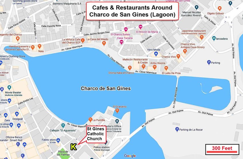
The Playa de Reducto Beach Area

                           A) Playa de Reducto Beach GPS = 28°57'29.9"N 13°33'34.1"W
                           This is the closest beach to the Cruise Port. The water is calm because the beach is protected
                           by a reef. It’s a clean, well maintained, comfortable beach for swimming and sun bathing.
                           Playa de Reducto has “Blue Flag” EU beach status due to excellent services including toilets,
                           showers, telephones, restaurants, parking, kiosk, taxi and bus stops. You can rent a chair or
                           umbrella for ~ a euro. The beach is in the heart of the hotel and resort area.
                           B) Gran Hotel and Spa GPS = 28°57'26.5"N 13°33'15.7"W
                           It’s an impressive high rise building next to the beach photo left.
                           Note the taxi cabs lined up along the street.
                           C) Parque Isas Canarias: Walk East toward center city. There will be shops and restaurants
                           on the north side of the street and a beautiful promenade along the waterfront on the south side
                           of the street.

Arrecife-Lanzarote-Spain                 Page 7 of 23                               © Copyright www.TomsPortGuides.com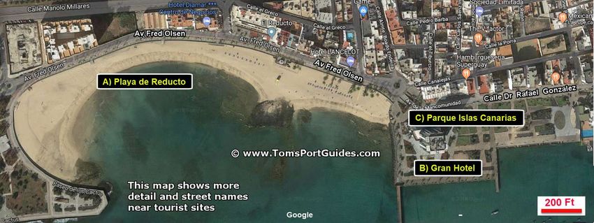
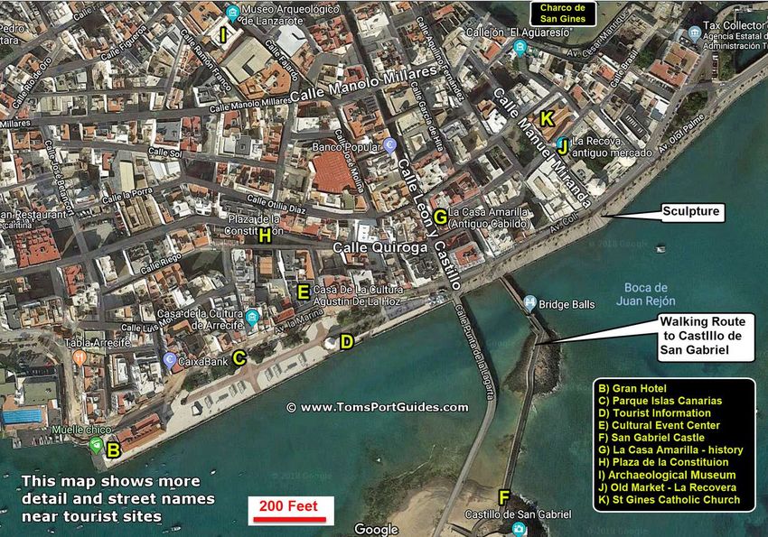
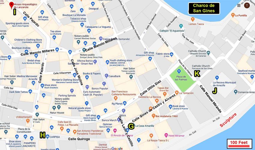
These are the most popular tourist sites between Playa Reducto Beach and Charco de San Gines (Lagoon)

Arrecife-Lanzarote-Spain                                        Page 8 of 23                          © Copyright www.TomsPortGuides.com
Details for the map on page 8
D) Tourist information Center GPS = 28°57'28.6"N 13°32'57.2"W
Photo Below: The Tourist Information Center is in a building that replicates a bandstand. It’s a good idea to
stop at the tourist center to learn what the current activities are in the city. For example, you might want to ask
what events and activities are currently scheduled at the Cultural Event Center.

E) Cultural Event Center Casa De La Cultura Agustín De La Hoz GPS = 28°57'29.8"N 13°32'57.9"W
See this youtube video on the cultural center. https://www.youtube.com/watch?v=e2L4VzbXmOo
It’s a beautiful building that showcases the work of several artists and is used for exhibitions, music, concerts,
dance, conferences, workshops, and events. Also, there’s a restaurant and bar.
F) Castillo de San Gabriel (Castle of Saint Gabriel) GPS = 28°57'23.2"N 13°32'51.2"W
Photo Above: It’s on a small island accessed by a foot on a drawbridge called Ball Bridge. The original wood
castle was burned, so it was replaced by a stone castle in 16C. It’s a great place to take pictures of the area.
The entry fee is ~ 3 Euros. All the information is in Spanish.
Open hours: Tuesday to Friday 10.00 to 13.00 hrs and 16.00 to 19.00 hrs. Saturdays 10.00 to 13.00 hrs.
     When you leave the castle, walk straight north across the promenade to Calle Leon y Castillo, also
     called “Calle Real”. It’s the most important shopping street in Arrecife. Plan on spending time
     walking on this street and exploring the shops and cafes on nearby side streets.

G) La Casa Amarilla History Museum
GPS = 28°57'31.8"N 13°32'53.7"W
Website
 http://www.cabildodelanzarote.com/tema.asp?idTema=253
The museum is a photo exhibit of the history of Lanzarote
Island. Text information is in Spanish, but the exhibits are
easy to understand because they’re based on postcards and
other photos. There’s a store that sells craft objects,
stationery, art publications, textiles and jewelry. This is a
very popular museum.
Hours Monday- Friday 10 am – 8 pm Saturday 10 am to 2
pm Admission 2 Euros

Arrecife-Lanzarote-Spain                          Page 9 of 23                © Copyright www.TomsPortGuides.com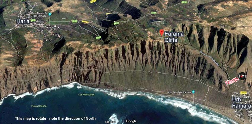
H) Plaza de la Constitution GPS = 28°57'31.4"N 13°32'57.8"W
Be sure to explore the side streets such as Plaza de la Constitution where you’ll find outdoor cafes.

I) Archaeological Museum GPS = 28°57'37.6"N 13°33'00.1"W
https://www.coolturalanzarote.com/en/the-archaeological-museum-of-lanzarote-opens-two-of-its-rooms-to-the-public/
Description from the museum website:
The museum uses “virtual reality” to create the
sensation of “being” on an archaeological
excavation. Touch screens show cave paintings, and
360-degree images. Exhibits cover volcanic
eruptions, underwater archaeology showcasing
objects found on the seabed of the island, such as
amphoras, cannonballs and a pipe. There’s also a
special section dedicated to explaining the pirate
attacks suffered by the island between the fourteenth
and eighteenth centuries. In addition, the room
contains a copy of the book “Le canarien”, written
by the Normans upon their arrival on the island, in
which the conquest of Lanzarote is narrated. Room
A also includes one of the jewels of the island’s historical heritage: the mummy of an ancient inhabitant of
Lanzarote. And it is that the world of the death of the majos is one of the great enigmas of the insular
archaeology due to the lack of confirmed and cataloged graves. This is probably due to the great geological
transformation that the island has undergone in its most recent history due to volcanic eruptions and the
invasion of jable in the 18th and 19th centuries.
The museum is open Tuesday to Friday 10:30 to 5:00 pm, and Saturdays, 10:30 to 2:00 pm.
The entrance fee is 3 Euro

Arrecife-Lanzarote-Spain                         Page 10 of 23                © Copyright www.TomsPortGuides.com
This Google Map shows many shops, cafes, restaurants, banks, etc. in the Arrecife Main Tourist Area
                       This area is packed with places to visit and explore. Note the map scale of 100 feet.

Arrecife-Lanzarote-Spain                                Page 11 of 23                     © Copyright www.TomsPortGuides.com
J) Old Market La Recova Antiguo Mercado GPS = 28°57'34.3"N 13°32'49.8"W
If you are walking along the waterfront, turn north at the sculpture on the
boardwalk (Photo at Left) and walk North along Calle Manuel Miranda.
You’ll see the tower of San Gines
church in the distance. The market
is in a square surrounded by
buildings, so you’ll have to enter
though a doorway. One of the
entrance doors is shown in the
(Photo at Right).
The Old Market has many products including fruits and nuts, vegetables,wine, cheese, sausage, herbal products,
etc. There are several small workshops where craftsmen sell their products including handmade jewelry and a
shoe store. Also there’s a flower shop, and bakery. The market is open Monday through Saturday 9 am to 2 pm
and closed on Sunday.
K) San Gines Catholic Church GPS = 28°57'34.4"N 13°32'50.3"W
Saint Ginés (Saint Genesius of Clermont) is Arrecife’s
patron saint. The church is built on the site of a hermitage
that had images of Saint Peter and Saint Ginés.
Mass Schedule:
Monday & Friday at 7:30 pm.
Saturday 1:15 pm. & 7:30 pm.
Sundays at 10:30, 12:00 & 7:30 pm.
To the east of the church is the large inland lagoon called
Charco de San Gines, named after Saint Gines. The map
on the next page shows the cafes and restaurants around
the lagoon. Note that most of the restaurants are on the
north side of the lagoon.
The shuttle buses from the cruise ships usually drop
passengers off next to Charco de San Gines so it’s only a
short walk to the tourist sites
Arrecife-Lanzarote-Spain Page 12 of 23 © Copyright www.TomsPortGuides.comNote that the Cafes and Restaurants are on the north side of the Lagoon because the west side is lined with private houses with the backyard patios of the homes facing the lagoon. Arrecife-Lanzarote-Spain Page 13 of 23 © Copyright www.TomsPortGuides.com
Castillo de San José International Contemporary Art Museum GPS = 28°58'15.7"N 13°31'59.6"W
See the map on page 5 of this guide. The museum is built into an old fortress. It has a restaurant, bar, and great
views of the bay. Adult admission is 4 Euros. Hours are 10 am to 8 pm. See
http://www.cactlanzarote.com/en/cact/museo-internacional-arte-contemporaneo/#1455148589098-1ad4a5be-b0a57030-49d4
Download the descriptive leaflet from
http://www.cactlanzarote.com/wp-content/uploads/2016/06/inglesmuseo.pdf
It’s a long walk from the cruise port to this art museum. Consider a taxi or the City Sightseeing train.
                       Popular Tourist Sites OUTSIDE the City of Arrecife
See the map on Page 4 of this guide where I show #1 as the cruise port and #2 as Center City Arrecife
3) Lanzarote Airport GPS = 28°57'08.1"N 13°36'24.4"W A 10 minute, 11 km ride from the cruise port.
Lanzarote Airport (IATA: ACE ICAO: GCRR), (in Spanish Aeropuerto de Lanzarote), is located 5 kilometers
southwest of Arrecife, the capital of the island. The airport is the main gateway for both domestic and
international tourists, allowing up to 6 million passengers a year. Code ACE.
4) Puerto del Carmen GPS = 28°55'22.6"N 13°40'05.3"W A 17 minute, 19 km ride from the cruise port.
It was originally a fishing village. Today is a beautiful resort town with beautiful beaches, excellent seafood
restaurants, shopping, casinos, resort hotels and more!
5) Bodega la Geria = 28°58'09.5"N 13°42'53.3"W A 24 minute, 25 km ride from the cruise port.
Bodega (bō-ˈdā-gə) means “storehouse for maturing wine”.
It’s a vineyard of unusual design due to the difficulty growing
grape vines on a dry, volcanic island with black sandy soil.
The challenges are to 1) modify the volcanic soil so that it will
hold moisture for the roots to grow, 2) collect all the rain that
falls, and 3) protect the vines
from drying winds.
The solution is to a) dig
conical holes to collect all
the rainfall and protect the
grape vines from drying
winds, b) mix some fertile
water retaining soil at the
bottom of the hole where the
roots are planted, c) place
the grape vines in a circle on
the ground in the conical
holes, and d) pile rocks
around the top of the conical
holes to keep the sandy soil
from moving and to reduce
drying wind on the vines.
It looks strange to see grape
vines growing in conical
holes in black, sandy
volcanic soil. But it
obviously works, the wines
are excellent!

Arrecife-Lanzarote-Spain                         Page 14 of 23                © Copyright www.TomsPortGuides.com
6) Visitor Center for the 12,600 acre Timanfaya National Park GPS = 29°00'20.4"N 13°45'11.4"W
A 37 minute, 37 km ride from the cruise port.
The volcanoes are dormant, but the temperature below ground can be
as high as 800 degrees. At the visitor center, a guide pours water into
a pipe driven into the ground. In a short time, a geyser erupts.
This is an amazing place to visit. As you drive through the park, the landscape “moonscape” changes in texture
from sandy soil to rugged rocks and volcanic craters. Colors change from yellow to tan to brown to red to
black. There are announcements on the bus to explain the history of what you are seeing. The bus slows and
stops, but you stay on it and take all photos through the windows. There may be reflections in the photos.
View of volcanoes from the Visitor Center Note the colors of yellow, tan, red, and brown
Arrecife-Lanzarote-Spain Page 15 of 23 © Copyright www.TomsPortGuides.comNote the landscape texture with sand and rocks
Looking down into a crater
Use the white bus on the right side of this photo to judge the scale.
Arrecife-Lanzarote-Spain Page 16 of 23 © Copyright www.TomsPortGuides.comNote the bus in the right in the photos below.
The volcanoes are often described as a “moonscape”.
This looks like a moonscape, but the moon doesn't have tourist buses
Arrecife-Lanzarote-Spain Page 17 of 23 © Copyright www.TomsPortGuides.comArrecife-Lanzarote-Spain Page 18 of 23 © Copyright www.TomsPortGuides.com
7) Camel rides on the sand dunes GPS = 28°59'28.4"N 13°44'32.3"W
A 28 minute, 31 km ride from the cruise port. This Google map shows the parking lot for the camel rides. Note
the scale of 100 feet and the location of the Cafe, souvenirs, and toilets. The camels are lined up on the sand on
the west side of the parking lot.

This was the first time my wife and I had been on a camel
ride. We loved it and highly recommend it. There were
families with children, teenagers, and old people like us
riding the camels. The camels are very interesting and peaceful animals. Two people sit in chairs with one
person on each side of the camel. You get in the chairs when the camel is lying down as shown in the photo
above left.
Camels are strong animals. They stand up with two adults on their back and move slowly as they walk up and
down the sand dunes. There is a slow, side to side movement as the camel walks. A trainer is at the head of the
line next to the first camel. The trainer will tell you the name of your camel so you can talk to your camel.
A trainer walks with a small group of camels up and down the sand dunes. You’ll love the camel ride!

Arrecife-Lanzarote-Spain                        Page 19 of 23               © Copyright www.TomsPortGuides.com
8) Playa del Janubia is a long, black sand beach near the salt flats. GPS = 28°56'14.4"N 13°49'54.1"W
A 32 minute, 36 km ride from the cruise port. It’s unsafe for swimming due to waves and undertow. Some use
it as a nude beach.

9) Cesar Manriqe Foundation GPS = 29°00'06.5"N 13°32'51.6"W
A 6 minute, 5 km ride from the cruise port. It’s the former home and gardens of a very creative artist built on a
volcanic trail using five volcanic bubbles to create the home living space on multiple levels. Admission is 8
Euros. Open every day 10 am to 6 pm. Watch this 4 minute YouTubeVideo for a walking tour of the home and
gardens. https://www.youtube.com/watch?v=BMQvD6w8Dz8 Note the stairs in this multi-level, unique home.
Website = http://fcmanrique.org/casas-museo-visitas/fundacion-cesar-manrique-tahiche/?lang=en
Photo below shows an outside pool. See the aerial map view at right below.

Arrecife-Lanzarote-Spain                        Page 20 of 23               © Copyright www.TomsPortGuides.com
10) Hiking trails for views of Famara Cliffs GPS = 29°07'20.5"N 13°31'39.9"W
A 36 minute, 26 km ride from the cruise port.
The cliffs are 1750-2200 feet above the sea offering dramatic views of the northwest coast. There are hiking
trails along the top of the cliffs. The map below has been rotated. North is at the left, bottom corner of the map.
The village of Haria is north of Famara Cliffs as shown on this map.
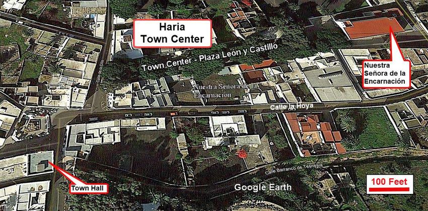
11) Haria GPS = 29°08'45.6"N 13°30'00.1"W A 29 minute, 30 km ride from the cruise port.
Why people visit and vacation in the village of Haria
A) Haria has the most fertile soil with a unique, humid micro climate on the desert island of Lanzarote. It’s the
“Valley of the thousand palms” with green fields, geraniums, wildflowers, and bougainvilleas around houses.
B) This scenic, colorful area near the mountains is different from other areas on the island. Haria attracts artists
Arrecife-Lanzarote-Spain Page 21 of 23 © Copyright www.TomsPortGuides.comand craftsmen. César Manrique, the famous artist, retired here and is buried here. Hence, tourists are drawn to this area to visit the art and craft shops and galleries. C) The Town Center market, Plaza León y Castillo, is open every Saturday from 10 am to 2 pm (see map on page 20). There are dozens of stalls selling a wide variety of products including painting, art and crafts products, jewelry, pottery, fruit & vegetables, cheese, bread, dried fish, with food stalls and nearby restaurants. D) You’ll see historic houses around town square, Plaza León y Castillo GPS = 29°08'47.6"N 13°29'56.6"W The church of Nuestra Señora de la Encarnación parish church has a sacred art museum. GPS = 29°08′48.7″N 13°29′53.5″W E) From the nearby mountains you’ll have scenic views of the cliffs, the sea, the town of Haria and the countryside. You can drive along narrow road to the scenic viewpoints, ride a bike in the area, and hike trails. Mirador de Haria, 3 miles south of Haria , is a popular viewpoint for breathtaking views of the coast, cliffs, villages, and Peñas del Chache, the highest mountain on Lanzarote Island. 11) Jameos del Agua GPS = 29°09'27.8"N 13°25'54.7"W A 25 minute, 28 km ride from the cruise port. Entrance fee = 9 Euros. See this YouTube Video https://www.youtube.com/watch?v=1ebd0lvylJQ It’s a volcanic cavern with tunnels and a lake that has been transformed by the artist, Cesar Manrique, into a beautiful site with a garden entrance, a 600 seat auditorium for concerts, a pool, and a bar. If you have mobility issues, this may not be a tourist site for you. You’ll need reasonable mobility, balance, and stability to walk on irregular steps of different heights that can be difficult to negotiate. The risk of falling is increased because some of the steps may be wet. We met with the shore excursion manager on our ship to help us decide whether this would be a suitable excursion for us. His opinion, and I believe he was correct, was that it would not be good for us due to our mobility issues. We took a bus tour through the volcanic park, a camel ride, and visit to a winery and loved it. 12) Mirador del Rio viewing platform from the mountain top GPS = 29°12'49.8"N 13°28'52.2"W A 32 minute, 34 km ride from the cruise port. It’s a cafe-bar with huge glass windows providing spectacular views from the mountain top of the northern coastline of Lanzarote of the cliffs, coastline, and sea below with the small island of La Graciosa in the distance. You can take photos from inside or outside the cafe. Admission is 4.5 Euros. Arrecife-Lanzarote-Spain Page 22 of 23 © Copyright www.TomsPortGuides.com
User Feedback Is Welcome
Goal
My guides are designed to help you plan a great cruise vacation by providing information such as where the
ship docks, location of tourist sites, public transit, walking tour maps, things to see and do, travel issues unique
to the port, etc. Knowledge of ports is important when planning self-guiding touring and booking shore
excursions because you have to make many decisions and commitments long before your ship docks.
NOTE: I believe the information in this guide is accurate, however you are responsible to verify accuracy of the
information you use to plan your vacation. Information on cruise ports frequently changes such as bus routes,
admission fees to sites, rental car locations, etc.
Cruise Critic is the best source for up-to-date, detailed, accurate information on travel details for shore
excursions, reviews of cruise ships, etc. There are many knowledgeable people on Cruise Critic willing to share
their knowledge, expertise, and travel experience. I highly recommend www.CruiseCritic.com, it's free to join.
Why feedback is important
User feedback helps me improve the format and content in my quest to produce the “ultimate” port guides. I
welcome offers to collaborate with me or provide materials for use in my guides.
PLEASE Help “spread the word” about my website and port guides.
The only negative feedback I get is, “I wish I knew about your port guides before my vacation”.
Please tell your friends and post a link to my guides and website on the blogs.
The best way to share information about my website and my guides is to:
        Post a link to my website e.g. https://www.tomsportguides.com or
        Post a link to my guide For example, the link to my Rome Guide is
        https://www.tomsportguides.com/uploads/5/8/5/4/58547429/rome-port-guide-2018.pdf
        I want to thank all of you who have posted and recommended my port guides and website.
If you want to be notified when a new guide is published,
        send your email address to me at TomsPortGuides@gmail.com
             Copyright Notice & Terms and Conditions for Use of My Guides
My port guides and everything on my website https://www.TomsPortGuides.com is copyrighted by Thomas
Sheridan with all rights reserved, and protected by international copyright laws.
PROHIBITED USE of my port guides and/or material from my website.
Unfortunately, I have encountered copyright violations involving illegal copying, distribution, and copycat
websites that “appear” to have my approval to distribute my guides on my behalf. That is not true, these
copycat sites are violating my copyrights!!!
NO person, company, organization, website, etc. is permitted to distribute my guides, or excerpts from my
guides as electronic, digital, or paper copies, place my materials or guides on another website, sell, or require a
membership, or subscription to download my port guides or materials from their website.
The legal, and best way, to share information about my website or guides is to post links as described above.
NO Cruise Ship employee, representative, contractor, port lecturer, travel writer, publisher, speaker, etc. is
permitted to include or distribute excerpts from my guides or material from my website as electronic, digital or
paper copies, or in presentations. A blatant example of copyright violation was a cruise ship docked in
Copenhagen where shore excursion personnel removed maps from my guide and copied/distributed my maps.
Fortunately, a friend of mine on that ship complained to the purser and the ship stopped violating my copyright.
If there is any question about permitted use of my guides, contact me at TomsPortGuides@Gmail.com
I wish you a great cruise vacation.
Tom Sheridan

Arrecife-Lanzarote-Spain                         Page 23 of 23               © Copyright www.TomsPortGuides.com
You can also read