Transalpine pass routes in the Swiss Central Alps and the strategic use of topographic resources
←
→
Page content transcription
If your browser does not render page correctly, please read the page content below
Preistoria Alpina, 42 (2007): 109-118 ISSN 0393-0157
© Museo Tridentino di Scienze Naturali, Trento 2007
Transalpine pass routes in the Swiss Central Alps and the strategic use of topographic
resources
Philippe DELLA CASA
Department of Pre-/Protohistory, University of Zurich, Karl-Schmid-Str. 4,
���������������������������
8006 Zurich, Switzerland
E-mail: phildc@access.uzh.ch
SUMMARY - Transalpine pass routes in the Swiss Central Alps and the strategic use of topographic resources - Using
examples from the San Bernardino and the St. Gotthard passes in the Swiss Central Alps, this paper discusses how
the existence of transalpine high altitude pass routes can be inferred, even though there is a lack physical evidence,
from specific Bronze and Iron Age settlement patterns in access valleys. Particular attention is given to the effect of
topography within the territorial and economic organizational area on transalpine tracks and traffic routes. A set of
recurring patterns, such as strategic position, natural and/or artificial protection, presence of “foreign” materials, can
help identifying (settlement) sites with particular functions as regards traffic and trade within the systems of territorial
organization. Moreover, the paper also addresses socio-dynamic issues of the problem of transalpine pass routes.
RIASSUNTO - Passi transalpini nelle Alpi Centrali Svizzere e uso strategico di risorse topografiche - Usando esempi
dal Passo di San Bernardino e dal Passo del San Gottardo nelle Alpi Centrali Svizzere, il presente contributo discute
come l’esistenza di vie di transito transalpine d’alta quota possa essere dedotta, anche mancando evidenze fisiche,
da specifici modelli insediativi dell’età del Bronzo e del Ferro presenti nelle valli di accesso. Particolare attenzione
è data all’effetto della topografia dell’area organizzativa territoriale ed economica sulle vie di transito e commercio
transalpine. Una serie di modelli ricorrenti, come la posizione strategica, le protezioni naturali e/o artificiali, la pre-
senza di materiali alloctoni, può facilitare l’identificazione di siti (di insediamento) con particolari funzioni, come il
traffico e il commercio all’interno dei sistemi di organizzazione territoriale. Inoltre, l’articolo propone anche modelli
socio-dinamici per le vie di transito transalpine.
Key words: Switzerland, Alpine pass routes, prehistory, settlement, topography, resource management
Parole chiave: Svizzera, passi alpini, preistoria, insediamento, topografia, utilizzo di risorse
1. INTRODUCTION ted with these studies do not reflect the physical and
human preconditions to the existence of prehistoric
There has been, over the last few decades, an ongo- transalpine routes.
ing discussion about the use of transalpine pass routes Pass routes are often discussed on the basis of ar-
in prehistory for the purpose of communication, cul- chaeological findings in valleys or contact finds, and
tural transfer and trade. Many of the claims for the exis by recent or near recent ethnographic analogy. As the
tence of Alpine pass routes are what could be termed Alpine passes lie beyond the usual areas of settlement,
“views from the outside”, based on distribution patterns there is a clear lack of direct evidence. Alternatively,
of specific artifacts, raw materials or cultural traits in single finds in high altitude locations (1500 m and
geographical zones north and south of the Alps (e.g. above)1 and along pass roads have been used to pos-
Kimmig 1983; Sherratt 1993). tulate zones of prehistoric economic activities along
In general, these approaches do not deal with the with alpine and transalpine axes of communication.
topographic or cultural realities within the Alpine area, Taken alone, these finds – though valuable indicators
nor the parameters that allow for the establishment of human presence and activity in the higher altitudes
and maintenance of such pass routes. The correspond- of the Alps – can, again, not elucidate the structural
ing maps of communication or trade activities associa context of transalpine routes. However, their inter-
1
All altitude indications are given above mean sea level.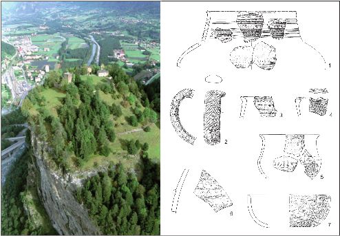
110 Della Casa
Transalpine
pass
routes
in
the
Swiss
Central
Alps
pretation has more recently focused on ritual deposi- 2. STUDY AREA AND METHODS
tional behavior (see Wyss 1989; Neubauer & Stöllner
1994). Geographically, the research area lies in the very
A third line of evidence, that of actual physical re- heart of the Alps, and covers the valleys leading to
mains of alpine tracks and roads, suffers both from two of the major transalpine crossings of today: the
difficult geomorphological conditions of preservation St. Gotthard pass and the San Bernardino pass (Fig.
and the quasi-impossibility of dating, at least for pre- 1). A somewhat wider area corresponding roughly to
historic periods. the west- to east-central Swiss Alps will be taken into
In many cases, however, from physical and writ- consideration for the discussion.
ten sources there is evidence of roads that suggest
a continuity of use of medieval and modern transal- Over the last twenty years, a number of both large
pine axes back to Roman times, and can help indi- and small research projects have been carried out in
cate zones of particular interest for the discussion this zone by the Department of Pre-/Protohistory of
of prehistoric routes (e.g. Cardani Vergani & Co- the University of Zurich in collaboration with local
lombo 2002). heritage management services of the Cantons of Uri
Based on the results of a series of research projects (UR), Graubünden (GR), and Ticino (TI). These pro
run by the University of Zurich together with local part- jects were carried out in the Reuss valley north of St.
ners in the Swiss Central Alps, this paper seeks to in- Gotthard (Primas et al. 1992), in the Alpenrheintal
vestigate some specific geographical preconditions and (Primas et al. 2001, 2004) and the Lower Rhine val-
strategies of resource management in order to better un- ley and San Bernardino pass region (Della Casa et al.
derstand the role of local Alpine Bronze and Iron Age 1999), in the Mesolcina valley south of San Bernardi-
populations within the framework of transalpine con- no (Della Casa 2000; Schmid-Sikimic 2002a), and the
tacts and pass routes. zone between Arbedo (TI) and Lake Verbano (Giubi-
Fig. 1 - Overview satellite map of the areas discussed in the text.
Fig. 1 - Carta panoramica satellitare delle aree discusse nel testo.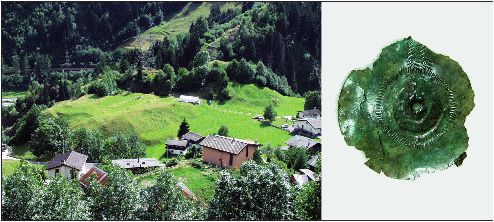
Preistoria Alpina, 42 (2007): 109-118 111
asco: Tori et al. 2004; Pernet & Carlevaro et al. 2006), 2) Transalpine contacts are evidenced from the Neo-
and more recently in the Leventina valley south of St. lithic and Copper Age onwards through exotic raw
Gotthard pass2. materials and contact finds (e.g. Mottes 2002). Con-
These projects include comprehensive mappings of tact finds in settlements and graves are particular-
archeological finds of pre- and protohistoric periods, ly numerous in the 1st millennium BC, both in zo-
revisions of sites and find complexes (settlements, ce nes outside the Alpine massif (Po plain, northern
meteries), extensive and intensive field surveys, sub- forelands) and inside the Alpine valleys where, for
surface tests excavations and full scale excavations, as example, objects of south-alpine Golasecca type
well as geomorphological and archaeobiological investi indicate the crossing of Alpine passes northwards
gations. They produced a wealth of new data and al- (Schindler 1998; Schmid-Sikimic 2002a). This can
lowed the proposal of a range of models on pre-/proto- be viewed as a subset of supra-regional north/south
historic Alpine settlement activities, resource manage- trade activities (Kimmig 1983).
ment, economic strategies and social networks (Della
Casa 2000, 2002; Schmid-Sikimic 2002a, 2002b; Pri- A number of research questions arise from this,
mas et al. 2001, 2004). pertaining to the cultural, social and economic reality
Particular attention was paid to settlement topogra- behind the archaeological evidence: Are there specific
phy and site diversification in a transnational and dia- elements in the settlement structure relating to com-
chronic study concerning selected areas of the eastern, munication, traffic and trade? What can be said about
central and western Alps (Della Casa 2002). Parame- the roles of individuals and society in the organization
ters were set that allowed for the identification of sett of transalpine contacts?
lement sites sensu stricto (see above), while alterna-
tive interpretations for non-permanent settlements and
other sites with specific socio-economic background 3. RESULTS
were discussed (Della Casa 2002: 11-13, 69-72).
In all test areas, starting with the Copper Age, si-
This paper focuses on a particular aspect of Alpine tes occurred that would not fit into the basic pattern
socio-economic strategies: the use of local topogra- described for agro-pastoral subsistence organization.
phy in the structuring of settlement and the organiza- Such sites were usually located in conspicuous topo-
tion of supra-regional contacts. Specific locations and graphic settings such as naturally defended hillocks or
situations of Bronze and Iron Age sites along the pass ledges, in the vicinity of gorges, valley latches or river
routes of San Bernardino and St. Gotthard are analyzed crossings, and quite often along later medieval or mo-
and set into a more general framework of both Alpine dern traffic routes. Lack of space, fresh water, nearby
settlement and socio-economic activity, including the arable or pasture land, and often modest archaeologi-
use of high altitude pass zones for the transit of peo- cal find spectra, make these locations unlikely for per-
ple and objects. manent settlement. They are viewed as separate featu-
The primary position of this paper can be summa- res within the overall settlement structure, with speci-
rized by two main points: fic functions of territorial organization, protection, and
1) Colonization of the Central Alps by agro-pastoral control (Della Casa 2002: 72). A number of such ar-
groups is well ascertained from the Copper Age chaeological features can be described along the pass
through to the Roman conquest by direct archaeo- routes of San Bernardino and St. Gotthard.
logical (settlements) and indirect environmental evi-
dence (pollen analysis) (Della Casa 2000, 2002). 3.1. San Bernardino route
Settlement sites showing both archaeological and
biological findings relating to year-round or at least The San Bernardino pass route is the shortest and
long-term seasonal occupation cluster in recurring fastest connection between Lake of Constance and Ti-
topographical situations such as naturally protected cino (Fig. 2). It follows the Rhine valley up to the cross
river or slope terraces and hilltops with close-by ara- road of Tamins (GR) (670 m) at the confluence of Up-
ble land. There is a clear choice for climatically fa- per and Lower Rhine. A cemetery of Alpine Hallstatt
vorable locations (Della Casa 1998). graves of the late 8th to 6th century BC with many sou-
2
For preliminary reports see Jahrbuch der Schweizerischen Gesellschaft für Ur- und Frühgeschichte (SGUF) 87, 2004, 348; 88, 2005,
324; 89, 2006 (Regesten).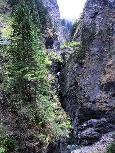
112 Della Casa
Transalpine
pass
routes
in
the
Swiss
Central
Alps
Fig. 3 - Viamala gorge, Thusis GR (photo author/UZH).
Fig. 3 - Gola Viamala, Thusis GR (foto autore/UZH).
3). Though cumbersome by-passes have been sugge-
sted for the prehistoric periods (see Planta 1990), it
seems just as probable to assume that the original track
– as in Roman and later times – led for its major part
through the gorge. An impressive promontory controls
and defends the starting point of the track on the right
side of the gorge, today known as Veia Travesina: the
castle hill of Sils i.D. (GR) Hohenrätien (Crap Sogn
Fig. 2 - The San Bernardino route, between Lake of Con- Gion – 950 m).
stance and Bellinzona. Test excavations during the summer of 1997 led
Fig. 2 - Il passo di San Bernardino, fra il Lago di Costanza to the discovery of a number of pre- and protohistoric
e Bellinzona. strata and structures on Sogn Gion promontory, data-
ble to the Late Bronze, Early Iron, and (Late) Roman
periods (Della Casa et al. 1999). Floral and faunal re-
thern contact finds marks this important traffic junc- mains speak in favor of an at least a semi-permanent
tion (Schmid-Sikimic 2002a: 239-293). Several hill- settlement connected to lowland (valley) agricultu-
tops dominate the narrowing passage to the Domle- ral villages. Contact finds (mostly pottery) indicating
schg/Heinzenberg valley, prehistoric Bronze and Iron supra-regional connections are found in all strata/con-
Age finds being reported from at least two of them – texts, just as we would expect it for a site situated stra-
Bonaduz, (GR) Bot Panadisch and Rhäzüns GR Schlos- tegically along a traffic route (Fig. 4). Interestingly, a
shügel (Zürcher 1982). The route then remains easy to tollhouse is known to have been on Crap Sogn Gion
use until the entrance to the famous (and fearful) Via- during later historic periods.
mala gorge south of Thusis (GR). The gorge stretches
over 6.5 km and represents the most difficult part of the From Zillis (GR) at the southern end of the Viama-
entire route, as it is extremely steep and narrow (Fig. la, the San Bernardino route crosses the Schams valleyPreistoria Alpina, 42 (2007): 109-118 113
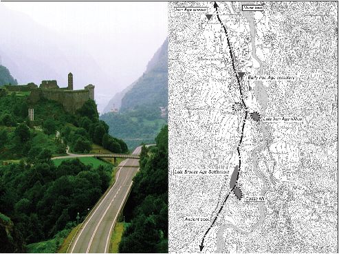
Fig. 4 - Hohenrätien, Sils i.D. GR: situation above the Lower Rhine valley (photo R. Jecklin/Hohenrätien). �������������������
Pottery finds, 50%
to scale: 1. north-Alpine Late Bronze Age; 2-3. Alpine Laugen-Melaun style, Late Bronze Age; 4-5. Alpine Tamins style,
Early Iron Age; 6. south-Alpine Early Iron Age; 7. north-Alpine Early Iron Age (M. Reuschmann/UZH).
Fig. 4 - Hohenrätien, Sils i.D. GR: situazione sulla Bassa Valle del Reno (foto R. Jecklin/Hohenrätien). Ritrovamenti ceramici,
50% grandezza naturale: 1. Età del Bronzo Finale nord-alpina; 2-3. Stile alpino di Luco-Meluno, età del Bronzo recente;
4-5; Stile alpino di Tamins, prima età del Ferro; 6. Prima età del Ferro subalpina; 7. Prima età del Ferro nord-alpina (M.
Reuschmann/UZH).
(a Bronze Age site is attested on the terrace of Donath ry BC) occupies the southern part of the river terra-
GR: Zürcher 1982) and leads through another terrain ce, where a rocky ridge inhibits easy passage. Mesoc-
handicap – the Rofla gorge – into the Rheinwald valley co castle dominates this well defended hilltop situa-
(1400-1600 m). Very few archaeological findings ha- tion, from which again Bronze Age finds are known,
ve so far been reported from this area, for which how and that makes – as in Hohenrätien – a perfect control
ever extensive forms of Alpine agro-pastoral economy post over the only possible valley track (Della Casa
cannot be excluded for prehistoric times (Della Casa 2000: 77-80). An Early Iron Age cemetery is located
1998). There is a turn-off towards the lake of Como in the actual village (nothing is known about the cor-
across Spluga pass in Splügen (GR). responding settlement) with metallic and ceramic fin-
dings that illustrate manifold transalpine connections
The high altitude part of the track leads from there (Schmid-Sikimic 2002a & b ). For the Late Iron Age
across the easily accessible pass at 2060 m rapidly de- (4th to late 1st century BC) we have structural and ma-
scending to San Bernardino village (1600 m), Pian terial evidence from yet another naturally defended hil-
S. Giacomo (1170 m), and down to Mesocco (GR) in lock called Gorda (Della Casa 2000: 83-91).
the Mesolcina valley bottom at 790 m (Fig. 5) whe-
re we have ample evidence of prehistoric settlement Down the Mesolcina valley, Arbedo (TI) – known in
(Della Casa 2000; Schmid-Sikimic 2002a). An exten- particular for its many rich Early Iron Age cemeteries
sive Late Bronze Age settlement site (14th-12th Centu- – marks (at the confluence of Moesa and Ticino) the114 Della Casa
Transalpine
pass
routes
in
the
Swiss
Central
Alps
Fig. 5 - Mesocco GR: castle hill seen from the north (photo author/UZH). Overall situation (prehistoric settlement zones are
indicated in shade).
Fig. 5 - Mesocco GR: collina fortificata vista da nord (foto autore/UZH). Situazione generale (le zone di insediamento prei-
storiche sono indicate con l’ombreggiatura).
terminus of the San Bernardino route. Based on writ- date for the opening of this north-south passage, in
ten sources reporting transalpine traffic with pack ani- particular because of the quasi-insuperable Schöllenen
mals in medieval and recent times, it can be assumed gorge (Aerni 1990), there is fair evidence from Roman
that the difficult part of the journey from Thusis to Me- finds (coins) that the pass was used at that period
socco would last four days, with several stage stops in (Primas et al. 1992: 16-22) and increasing evidence
between (Schmid-Sikimic 2002a: 200-215). Conside- that it was already known in prehistoric times (Schmid-
rable infrastructure, supported mostly if not entirely by Sikimic 2002a: 202-207). However, the northern access
the local Alpine population included upkeep of tracks, might not have been through the Schöllenen, but by
supply of guides, and provision of food and pack ani- using one or several possible bypasses (Z’Graggen
mals that would be necessary to maintain such a trans 1986) such as the Bäzberg or the Fellilücke-Oberalp-
alpine route. Val Canaria transect (Fig. 6).
The route has its onset in Flüelen (UR) at the
3.2. St. Gotthard route southernmost end of the Lake of Lucerne (or more
precisely the Urnersee, an easily navigable connection
Today there is an ongoing debate on the earliest use to the Swiss Plateau). Up the Reuss valley, the route
of the St. Gotthard route. It is an important transalpine reaches the junction at Amsteg (UR) (550 m) where
crossing with the shortest connection between the structures of a settlement datable to the Middle/Late
Swiss Plateau and the south Alpine lakes. While many Bronze and Early Iron Age have been unearthed
arguments have been raised for a rather late medieval (Primas et al. 1992: 279-306). The topographical settingPreistoria Alpina, 42 (2007): 109-118 115
per Age onwards (Primas et al. 1992: 235, fig. 39). As
stated above, it is for the moment impossible to speci-
fy the exact course of the pass track around Pizzo Cen-
trale, the very heart of the Central Swiss Alps. The St.
Gotthard pass is crossed at 2100 m, while some of the
proposed bypasses are at altitudes of around 2500 m.
The high altitude part of the route reaches at its
southern end Airolo (TI) at 1150 m in the upper Tici-
no valley called Leventina. This is again not an area
of dense archaeological findings; however, new field
archaeological investigations on the promontory of
Airolo-Madrano In Grop have led to the discovery of a
Bronze and Iron Age settlement in perfect strategic po-
sition (Fig. 8). The promontory is part of a rocky “latch”
that forms a major obstacle in the valley and compels
passage along the northern hillside and the hamlet of
Madrano. The In Grop promontory thus controls ac-
cess not only to the uppermost part of the Leventina
and the St. Gotthard pass, but also to the Val Canaria
as one of the possible secondary routes. It seems al-
most needless to detail that this settlement site is again
dominated by medieval ruins of a tower or castle on
Mött Chiaslasc.
Thus far, we have only preliminary archaeological
information on the site. Stratigraphy and radiocarbon
dates indicate an occupation covering the Middle and
Late Bronze Age (1500-1000 BC) as well as the second
part of the 1st millennium BC. In addition to the natu-
rally defended site location, access to the settlement
was restricted by a stone or stone and timber wall. Do-
mestic structures yield metal and ceramic finds along
with animal bone fragments, and a range of charred
seeds and grains indicating agricultural activity on or
in the vicinity of the site (see footnote 2). However,
the full extent of the site and holding area still needs
Fig. 6 - The St. Gotthard route, between Lake of Lucerne to be determined.
and Lugano.
Fig. 6 - Il passo del San Gottardo, fra il Lago di Lucerna Thanks to the longtime Swiss research program on
e Lugano. ancient traffic routes Via Storia3, we are rather well in-
formed on medieval and sub-recent tracks in the Leven-
tina. From Airolo down the valley, the next topographi-
is a medieval castle hill Flüeli (Zwing Uri) that controls cal obstacle is to be found at the Piottino gorge (Bel-
a natural narrowing of the valley and thus passage to lini 1990). An important toll station is known to have
the Gotthard track (Fig. 7). There are most interesting been in Piottino during later historic periods. Until the
contact finds pointing in southern and eastern directions construction of the first road through the gorge in the
among the pottery assemblages from this area (Primas 14th century AD, the easiest bypass was by way of Pra-
et al. 1992: fig. 113; Schmid-Sikimic 2002b). to-Leventina and Dalpe TI (1180 m) where two tomb
South of Amsteg, no prehistoric sites are known so groups of the Early Iron Age, some with northern con-
far, though single finds in the region of Realp and An- tact finds, illustrate that this was an area economically
dermatt (UR) indicate human presence from the Cop- exploited in prehistoric times. Other Iron Age ceme-
3
http://www.viastoria.ch116 Della Casa
Transalpine
pass
routes
in
the
Swiss
Central
Alps
Fig. 7 - Amsteg UR Flüeli. Map
�������������������������������������������������������������������������������������������������
indicates likely extension of archaeological area (dark grey shade). Pottery of south-Alpine
origin, 60% to scale (after Primas et al. 1992, modified).
Fig. 7 - Amsteg UR Flüeli. �������������������������������������������������������������������������������������������������
La mappa indica l’estensione approssimativa dell’area archeologica (ombreggiatura grigio-scuro).
Ceramica di origine sud-alpina, 60% della grandezza originale (da Primas et al. 1992, modificato).
Fig. 8 - Airolo-Madrano TI In Grop (photo author/UZH). ��������������������������������������������������������������������
Middle Bronze Age disk pendant (60% to scale; photo G. Pegurri/UBC).
Fig. 8 - Airolo-Madrano TI In Grop (foto autore/UZH). Pendente a disco dell’età del Bronzo medio (60% della grandezza
originale; foto G. Pegurri/UBC).
teries on the northern valley side might help to under- sca (TI) where it joins together with the Lucomagno
stand how traffic was staged in the Leventina in the 1st pass route (Cardani Vergani & Colombo 2002), and
millenium BC (Schmid-Sikimic 2002a: 210-214). finally Arbedo (TI) (see above 3.1). Using pack ani-
The St. Gotthard pass route goes southward to Bia- mals, to traverse the entire route from Flüelen to Arbe-Preistoria Alpina, 42 (2007): 109-118 117
do would have taken 5 days or more, depending on the topographic conditions played a crucial role in this sys
exact route and environmental conditions, as it would tem because they are the most obvious means of enfor-
have also on the San Bernardino route. cing control – both politically and economically – over
Alpine tracks and routes. In this sense, advantageous
topography represents a manageable resource that can
4. DISCUSSION AND CONCLUSIONS be of strategic territorial and economic use.
On a theoretical level, such a strategy of control must
Local settlement patterns and the topography of si- be seen as a subset within socio-economic models of
tes relating to the Bronze and Iron Age are excellent – expansion and regulation, both vital factors to survival
if indirect – indicators of the importance attributed to in Alpine environments (Netting 1981: 42; Della Casa
the major transalpine connections of the Central Alps 2002: 83). The use of topographic resources insuring
in prehistoric times: the San Bernardino pass and the control over communication and trade, and of human re-
St. Gotthard pass, to which we must add the Simplon sources for services and infrastructure along transalpi-
pass, and connecting routes in the Upper Valais. ne tracks, are tightly linked. Individual and group actors
The Simplon pass and connecting routes in the Up- played a decisive role in the establishment and mainte-
per Valais, located outside our main research area, show nance of this system. B. Schmid-Sikimic has for example
many topographical and archaeological features similar discussed the role of women within marriage networks
to the ones discussed, such as the Iron Age village of linking regions immediately south and north of the Al-
Waldmatte – situated at the valley junction of Brig-Glis, pine range (Schmid-Sikimic 2002a: 232-236).
Valais (VS) – with its many southern contact finds, and It is finally worth noting that the evidences for
the numerous Iron Age graves of the Upper Valais con- transalpine contacts, both from settlement sites and
taining south alpine Golasecca type materials (Curdy et single finds, tend to cluster chronologically into a
al. 1993). More recently, archaeological findings from few periods: the later Early Bronze, Middle Bron-
the Simplon pass area itself at around 2000 m. (Crotti et ze and early Late Bronze Age (18th to 10th cent. BC),
al. 2004) have evidenced the significance of this west- and the later Early Iron and Late Iron Age (7th to 3rd
central Alpine transit route, connecting Lake Verba- cent. BC). There is a lack of archaeological materials
no through the Toce valley with the Valais, the Bernese for the early 1st millennium BC which makes that
Oberland, and the western Swiss Plateau (Fig. 1). period difficult to interpret, although this (non-)evi-
There can be no doubt that besides the major trans dence accords with cultural developments on a Eu-
alpine routes described here, a fair number of minor ropean level (Trachsel 2004: 257-320) and climatic
alternative regional pass routes were used in prehi- phenomena (Della Casa 2002: 172-177). Current re
storic times. As long as we lack material evidence for search projects in the Leventina (see footnote 2) and
these routes, the high altitude single finds mentioned the lower Ticino valley / Giubiasco (Della Casa in:
above might help to identify the passages. In the central Tori et al. 2004) will further investigate these socio-
part of the Swiss Alps, examples can be given for the and eco-dynamic processes.
Flüelapass (2280 m), the Schlappiner Joch (2200 m),
the Valserberg/Tomülpass (2400 m), the Passo dello
Spluga (2215 m) – probably not a “secondary” rou- ACKNOWLEDGEMENTS
te –, the Grimselpass (2150 m) and the Hanigalp Pass
(2150 m) (see Neubauer & Stöllner 1994). Little mo- I wish to express my gratitude to the many collea-
re can be said about these regional pass routes as their gues who contributed with materials and ideas to this
access often lies outside well known and documented paper, namely Biljana Schmid-Sikimic, Margarita Pri-
settlement zones. However, in the case of Lumbrein- mas, Eva Carlevaro, Lionel Pernet, Luca Tori, Martin
Surin (GR) Crestaulta for example, contact finds in- Schindler, Martin Trachsel, and to the persons respon-
dicate southern connections across the Greina pass in sible for local heritage management services: Rossa-
the Bronze Age (Primas 1998). na Cardani Vergani and Giuseppe Chiesi for Ticino,
The overall situation, and in particular the strikingly Jürg Rageth for Graubünden, and Hans Stadler for Uri.
recurrent settings of sites on promontories, hillocks and Fieldwork was financially supported by the Swiss Na-
ledges along historic axes of traffic, clearly speak in fa- tional Foundation in Uri, the Foundation for Scientific
vor of both the particular importance of the most direct Research at the University of Zurich and the Verein für
transalpine routes (San Bernardino, St. Gotthard, Sim- Bündner Kulturforschung in Graubünden, and the Uni-
plon) and the careful attention paid to the organization versity of Zurich in Ticino. Lawrence G. Desmond kin-
of these routes in prehistoric times. As can be shown, dly helped me improve the original English text.118 Della Casa
Transalpine
pass
routes
in
the
Swiss
Central
Alps
REFERENCES romaine. ��������������������������������������������
Chronos, Zürich: 375 pp. (������������������
Collectio archaeo-
logica, 4).
Aerni K., 1990 - 1000 Jahre Siedlung und Verkehr im Schwei- Planta A., 1990 - Verkehrswege im alten Rätien. Band 4.
zerischen Alpenraum. Voraussetzungen und Ergebnisse. Verlag Bündner Monatsblatt, Chur: 269 pp.
In: Fehn K., Aerni K. & Egli H.-R., (eds) Siedlungspro- Primas M., 1998 - Der bronzezeitliche Landausbau in den Al-
zesse an der Höhengrenze der Ökumene. Am Beispiel der pen. In: Hänsel, B. (ed), Mensch und Umwelt in der Bron-
Alpen. Siedlungsforschung Band, 8: 9-42. zezeit Europas. Oetker-Voges Verlag, Kiel: 355-365.
Bellini G., 1990 - Le vie storiche al Piottino. �����������
IVS, Bern: Primas M., Della Casa Ph. ����������������������������
& Schmid-Sikimic B., 1992 -
28 pp. Archäologie zwischen Vierwaldstättersee und Gotthard.
Cardani Vergani R. & Colombo M., 2002 - Geschichte und Siedlungen und Funde der ur- und frühgeschichtlichen
Archäologie entlang der Lukmanierstrasse. In: Schne- Epochen. Universitätsforschungen zur Prähistorischen
kenburger G. (ed.) Über die Alpen: Menschen – Wege Archäologie, 12: 366 pp.
– Waren. ��������������������������
ArgeAlp, Stuttgart: 15-22. Primas M., Schindler M., Roth-Rubi K., Diaz Tabernero J. &
Crotti P., Curdy Ph. & Leuzinger U., 2004 - La region du Grüninger S., 2001 - Wartau – Ur- und frühgeschichtliche
Simplon (Valais), du Mésolithique à l’époque moderne. Siedlungen und Brandopferplatz im Alpenrheintal (Kan-
Ann. Soc. Svizz. di Preist. e d’Arch., 87: 271-278. ton St. Gallen, Schweiz). I. Frühmittelalter und römische
Curdy Ph. et al., 1993 - Brig-Glis/Waldmatte, un habitat Epoche. Universitätsforschungen zur Prähistorischen
alpin de l’âge du Fer. Fouilles archéologiques en Valais. Archäologie, 75: 191 pp.
Archeologia Svizzera, 16-4: 138-151. Primas M., Della Casa Ph., Jochum Zimmermann E. & Huber
Della Casa Ph., 1998 - Relief, Boden, Klima – Zusammen- R., 2004 - Wartau – Ur- und frühgeschichtliche Sied-
hänge zwischen Landschaften und Siedlungsmuster lungen und Brandopferplatz im Alpenrheintal (Kanton
am Beispiel der Täler nördlich und südlich des San St. Gallen, Schweiz). II. Bronzezeit, Kupferzeit, Meso-
Bernardino. In: Hänsel, B. (ed.), Mensch und Umwelt lithikum. Universitätsforschungen zur Prähistorischen
in der Bronzezeit Europas, Oetker-Voges Verlag, Kiel: Archäologie, 108: 311 pp.
367-372. Schindler M., 1998 - Der Depotfund von Arbedo TI und
Della Casa Ph., 2000 - Mesolcina praehistorica. Mensch
�����������
und die Bronzedepotfunde des Alpenraums vom 6. bis zum
Naturraum in einem Bündner Südalpental vom Mesoli- Beginn des 4. ������������
Jh. v. Chr. Antiqua, 30: 472 pp.
thikum bis in römische Zeit. Universitätsforschungen zur Schmid-Sikimic B., 2002a - Mesocco COOP (GR). Eisen-
Prähistorischen Archäologie, 67: 192 pp. zeitlicher Bestattungsplatz im Brennpunkt zwischen Süd
Della Casa Ph., 2002 - Landschaften, Siedlungen, Res- und Nord. Universitätsforschungen zur Prähistorischen
sourcen. Langzeitszenarien menschlicher Aktivität in Archäologie, 88: 312 pp.
ausgewählten alpinen Gebieten der Schweiz, Italiens und Schmid-Sikimic B., 2002b - Hochgebirge - ein Hindernis,
Frankreichs. Préhistoires, 6: 120 pp. das die Kommunikation fördert. In: Lang, A. & Salac V.
Della Casa Ph., Bass B. & Fedele F., 1999 - The Grisons (eds), Fernkontakte in der Eisenzeit, Konferenz Liblice
Alpine Valleys Survey 1995-97: methods, results and 2000. Praha: 110-133.
prospects of an interdisciplinary research program. In: ���� Sherratt A., 1993 - What would a Bronze-Age world system
Della Casa, Ph. (ed.)
��������������������������������������
Prehistoric alpine environment, look like? Relations between temperate Europe and the
society, and economy. Papers of the international col- Mediterranean in later prehistory. Journ. Europ. Arch.,
loquium PAESE ’97 in Zurich. Universitätsforschungen 1-2: 1-58.
zur Prähistorischen Archäologie, 55: 151-172. Tori L., Carlevaro, E., Della Casa Ph., Pernet L., Schmid-
Kimmig W., 1983 - Die griechische Kolonisation im Sikimic B. & Vietti G., 2004 - La necropoli di Giubiasco
westlichen Mittelmeerraum und ihre Wirkung auf dei TI, vol. I, Storia degli scavi, documentazione, inventario
Landschaften des westlichen Mitteleuropa. Jahrb. d. critico. Collectio archaeological, 2: 462 pp.
Röm.-German. Zentralmus. Mainz, 30: 5-78. Trachsel M., 2004 - Untersuchungen zur relativen und abso-
Mottes E., 2002 - Südalpiner Silex im nördlichen Alpen- luten Chronologie der Hallstattzeit. Universitätsforschun-
vorland. In: Schnekenburger, G. (ed) Über die Alpen: gen zur Prähistorischen Archäologie, 104: 340 pp.
Menschen – Wege – Waren. ���������������������������
ArgeAlp, Stuttgart: 95-105. Wyss R., 1989 - Handel und Verkehr über die Alpenpässe.
Netting R., 1981 - Balancing on an Alp. Ecological change In: Jankuhn, H., Kimmig W. & Ebel E. (eds), Untersu-
and continuity in a Swiss mountain community. Cam- chungen zu Handel und Verkehr der vor- und frühge-
bridge University Press, Cambridge: 278 pp. schichtlichen Zeit in Mittel- und Nordeuropa. V: Der
Neubauer W. & Stöllner Th. 1994 - Überlegungen zu bron- Verkehr, Verkehrswege, Verkehrsmittel, Organisation.
zezeitlichen Höhenfunden anhand eines kürzlich in der Vandenhoeck und Ruprecht, Göttingen: 155-173.
Ostschweiz gefundenen Vollgriffmessers. Jahrb. d. Röm.- Z’Graggen U., 1986 - Ein Verkehrsweg durch die Zentralal-
German. Zentralmus. Mainz, 41/1: 95-144.
����������������� pen in der Hallstattzeit? Helvetia archaeologica, 17/68:
Pernet L., Carlevaro E., Tori L., Vietti G., Della Casa Ph. & 112-119.
Schmid-Sikimic B., 2006 - La necropoli di Giubiasco Zürcher A. 1982 - Urgeschichtliche Fundstellen Graubün-
TI, vol. II,
���������������������������������������������
Les tombes de La Tène finale et d’époque dens. Rätisches Museum, Chur: 68 pp.You can also read