Tropical Rainfall Measuring Mission - 2011 Senior Review Proposal - Global Precipitation ...
←
→
Page content transcription
If your browser does not render page correctly, please read the page content below
Tropical Rainfall Measuring Mission
      Senior Review Proposal
              2011

                0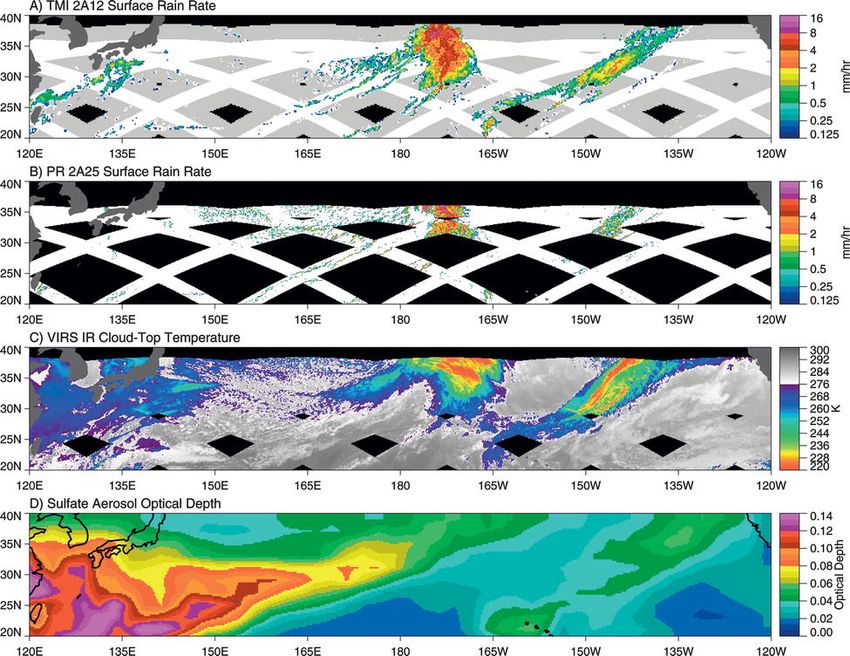
Tropical Rainfall Measuring Mission (TRMM)

                    0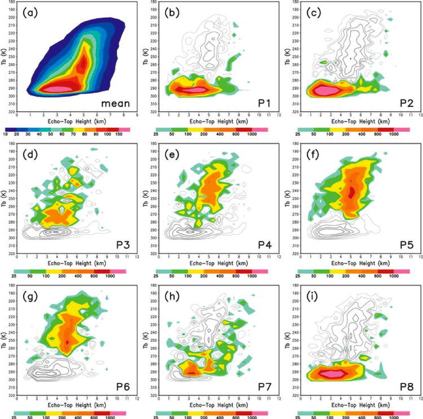
Tropical Rainfall Measuring Mission (TRMM)

                                                Table of Contents

Executive Summary                                                                        1
1. TRMM MISSION BACKGROUND, ORGANIZATION, AND STATUS                                     2
    1.1 Introduction                                                                     2
    1.2 History—Development, launch, boost                                               2
2. TRMM SCIENCE                                                                          3
    2.1 TRMM Project Science                                                             3
         2.1.1 Mission operations                                                        4
         2.1.2 Description of the TRMM instruments                                       4
         2.1.3 TRMM precipitation data processing                                        5
         2.1.4 LIS data processing                                                       6
         2.1.5 Ground validation data processing                                         6
    2.2 Summary of TRMM Accomplishments to Date                                          8
         2.2.1 Climate-related research                                                  8
         2.2.2 Convective systems and tropical cyclones                                  10
         2.2.3 Measurement advances                                                      12
         2.2.4 Applied research                                                          13
         2.2.5 Operational use of TRMM data                                              14
         2.2.6 National Academy Review                                                   15
    2.3 Science With an Extended TRMM Mission                                            16
         2.3.1 Improved climatology of precipitation characteristics                     18
         2.3.2 Inter-annual variations of precipitation                                  19
         2.3.3 Diagnosing/testing of inter-decadal changes and trend-related processes   19
         2.3.4 Improving analysis and modeling of the global water/energy cycle to
               advance weather/climate prediction capability                             20
         2.3.5 Tropical cyclone processes                                                20
         2.3.6 Characteristics of convective systems                                     20
         2.3.7 Hydrologic cycle over land                                                22
         2.3.8 Impacts of humans on precipitation                                        23
         2.3.9 Lightning                                                                 24
         2.3.10 TRMM combined with new, unique observations                              24
    2.4 Statement of Work                                                                25
         2.4.1 TRMM/PMM                                                                  25
         2.4.2 LIS                                                                       26
3. TECHNICAL SECTION                                                                     27
    3.1 Technical Status                                                                 27
         3.1.1 TRMM spacecraft operations status                                         27
         3.1.2 TRMM spacecraft status                                                    28
         3.1.3 Status of TRMM instruments                                                28
         3.1.4 TRMM end-of-life plan                                                     29
         3.1.5 Conjunction assessment/collision avoidance                                29
    3.2 Budget                                                                           30
         3.2.1 Mission operations in-guideline budget narrative                          30
         3.2.2 Data analysis in-guideline budget narrative                               30
Appendix A – TRMM Mission Data Product Summary                                           32
Appendix B – Budget                                                                      40
Appendix C – Acronyms                                                                    46
Appendix D – References                                                                  50

                                                         0
Tropical Rainfall Measuring Mission (TRMM)

                                      TRMM Senior Review Proposal
                                         Executive Summary
     The Tropical Rainfall Measuring Mission (TRMM), launched in late 1997, is a joint mission between NASA
and JAXA, the Japanese space agency. The first-time use of both active and passive microwave instruments and
the precessing, low inclination orbit (35°) have made TRMM the world’s foremost satellite for the study of
precipitation and associated storms and climate processes in the tropics. TRMM has met and exceeded its original
goal of advancing our understanding of the distribution of tropical rainfall and its relation to the global water and
energy cycles. TRMM has evolved from an experimental mission focusing on tropical rainfall climatology into the
primary satellite in a system of research and operational satellites used for analyzing precipitation characteristics on
time scales from 3-hr to inter-annually and beyond. Continuation of TRMM data will allow the community to better
link the TRMM data set to that of the Global Precipitation Measurement (GPM) mission to be launched in 2013.
     The overall science objective of an extended TRMM mission is to determine the time and space varying
characteristics of tropical rainfall, convective systems, and storms and how these characteristics are related to
variations in the global water and energy cycles. This TRMM goal is at the heart of NASA’s Earth Science strategy
and the answering of key science questions for both the Water and Energy Cycle and Weather focus areas, i.e.,
“How are global precipitation, evaporation and the water cycle changing?” and “How can weather forecast duration
and reliability be improved? Having a long, accurate record of quasi-global precipitation characteristics is
critical to achieving NASA Earth Science goals. The TRMM satellite and the associated science program will
provide that data and science to NASA and the world research community. The National Academy has already
spoken on this subject. In a 2006 independent assessment of the benefits of extending TRMM, they clearly stated
that “Considering the past and expected scientific and operational contributions presented in this report,
important benefits would be obtained if TRMM were extended until it runs out of fuel.” (NRC, 2006).
     Significant scientific accomplishments have already come from TRMM data, including reducing the uncertainty
of mean tropical oceanic rainfall; a documentation of regional, diurnal, and inter-annual variations in precipitation
characteristics; the first estimated profiles of latent heating from satellite data; improved climate simulations;
increased knowledge of characteristics of convective systems and tropical cyclones; and new insight into the impact
of humans on rainfall distributions. The availability of real-time TRMM data has led to significant applications
and fulfillment of national operational objectives through use of TRMM data, primarily in the monitoring of
tropical cyclones, in hydrological applications and in assimilation of precipitation information into forecast models.
     Extension of TRMM will result in: 1) an improved climatology of precipitation characteristics, especially
extremes; 2) diagnosis and testing of inter-decadal and trend-related processes in the water cycle; 3) assessment of
the impact of humans on rainfall characteristics and processes; 4) robust determination of convective system,
tropical cyclone, and lightning characteristics; 5) advances in hydrological applications over land (basin-scale
assessments, water management); 6) improved modeling of the global water/energy cycles for weather/climate
predictions; and 7) improved monitoring and forecasting of tropical cyclones, floods and other hazardous weather.
     The TRMM satellite and its instruments are in excellent shape and there is sufficient station-keeping fuel
on board to potentially maintain science operations until 2014 or later. TRMM flight operations and data
processing costs have been significantly reduced for the extension period. TRMM data processing has shifted to the
Precipitation Processing System (PPS), being developed as part of NASA’s Precipitation Program to process
TRMM, GPM and other relevant satellite precipitation data. The basic mission extension will continue production of
validation products that continue to contribute toward algorithm validation and improvement. A multi-year
extension of TRMM has a very high payoff for science and applications, but at a low additional cost to NASA.
In 2003, TRMM was merged with the GPM mission under the umbrella of the Precipitation Measurement Missions
program, with the TRMM Senior Review budget being responsible for both TRMM and GPM activities. TRMM
will be able to accomplish its goals within the guideline budget. GPM-related activities are increasing as launch
approaches in 2013, with emphasis on development of precipitation algorithms designed for the GPM instrument
suite and for mid-latitude precipitation. While the GPM goals can be achieved within the current guideline budget,
cuts to TRMM/GPM would impact GPM algorithm development and validation.

TRMM Project Scientist: Scott A. Braun (Laboratory for Atmospheres, NASA Goddard Space Flight Center)
Phone: 301-614-6316, e-mail: scott.a.braun@nasa.gov
Precipitation Processing System (PPS) Manager: Erich Stocker
TRMM Mission Director: Julio Marius

                                                           1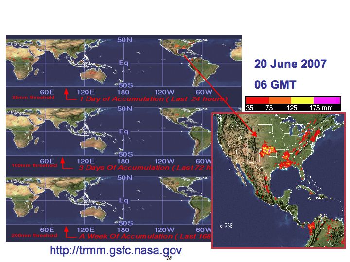
Tropical Rainfall Measuring Mission (TRMM)

1. TRMM MISSION BACKGROUND                                        lightning flash rates. The CERES Earth radiation budget
                                                                  instrument on TRMM failed after eight months of flight
1.1 Introduction                                                  and is not addressed here. Table 1 summarizes the
                                                                  characteristics of the TRMM rain instruments and Fig. 1
      The Tropical Rainfall Measuring Mission (TRMM)              shows the swath geometry of the various instruments.
is a joint project between NASA and the Japanese space            Detailed information on the TRMM instruments is
agency, JAXA. It was launched on November 27, 1997                given in Section 2.1.2.
and continues to provide the research and operational
communities unique precipitation information from                 1.2 History—Development, launch, boost
space well into 2011. The first-time use of both active
and passive microwave instruments and the precessing,                  The TRMM concept was developed in the 1980’s,
low inclination orbit (35°) make TRMM the world’s                 driven by a scientific need for climatological
foremost satellite for the study of precipitation and             precipitation information to understand the global water
associated storms and climate processes in the tropics.           cycle and for investigation of atmospheric convective
Complete information about the TRMM mission can be                systems, cyclonic storms and precipitation processes.
found       at    the    U.S.     TRMM        web      site       The first of a series of TRMM workshops was held in
http://trmm.gsfc.nasa.gov.                                        late 1986, with results described in a report (Simpson,
      The overarching TRMM science goal is to advance             1988) and journal article (Simpson et al. 1988). During
our knowledge of the global energy and water cycles by            the 1980’s, discussions and joint work between U.S. and
observing time and space distributions of tropical                Japanese scientists in the development and use of an
rainfall, convective systems and storms, and their                experimental aircraft precipitation radar evolved toward
associated hydrometeor structure and latent heating               interest in a joint satellite project.
distributions. TRMM has met and exceeded this                          The TRMM satellite was built in-house at Goddard
research goal and is a major observational success of             with the instruments delivered from manufacturers
NASA’s Water and Energy Cycle and Weather research                (including the PR from Japan). The assembled satellite
programs over the last decade. Continuation of TRMM               was then shipped by aircraft to Japan where it was
is critical to the future success of NASA’s water and             successfully launched from JAXA’s Tanegashima
energy cycle research through exploitation of TRMM’s              launch site on an H-II rocket on November 27, 1997.
extended data set, which with each additional year                The TRMM orbit altitude originally was 350 km and the
becomes increasingly valuable for climate variability             inclination 35°, so that the satellite covered the tropics
and climate change studies. Extension of TRMM also                and the southern portions of both Japan and the United
provides the potential of a cross-calibration overlap with        States. The precessing orbit also passes through all the
the Global Precipitation Measurement (GPM) mission                hours of the day, thereby giving a unique data set for
(or at least only a small gap), providing the possibility         observing the diurnal cycle of rainfall. The first full
of an unprecedented observational record of accurate              month of data was January 1998. Although the CERES
precipitation with which to probe climate variability and         instrument failed after eight months, all the precipitation
change within the water cycle from 1997 to 2013 and               package instruments (PR, TMI, VIRS) and the LIS have
beyond.
      The primary TRMM instruments are the
Precipitation Radar (PR), the first and only rain radar in
space, and the TRMM Microwave Imager (TMI), a
multi-channel passive microwave radiometer, which
complements the PR by providing total hydrometeor
(liquid and ice) content within precipitating systems.
The Visible Infrared Scanner (VIRS) is used to provide
the cloud context of the precipitation structures and is
used as part of a transfer strategy to connect microwave
precipitation information to infrared-based precipitation
estimates from geosynchronous satellites. These three
instruments form the original TRMM rain package and
are used singly and jointly to understand precipitation
processes, structure and climatology. In addition, the
Lightning Imaging Sensor (LIS), an Earth Observing
System (EOS)-funded instrument, has complemented
the rain sensors, improved understanding of convective            Fig. 1. Schematic of TRMM satellite and scanning
dynamics, and provided a climatology of global                    geometries of three rain package instruments.

                                                              2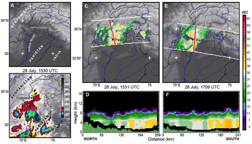
Tropical Rainfall Measuring Mission (TRMM)

                                 Table 1. TRMM Sensor Summary – Rain package
                                                                                                Visible and Infrared
                   Microwave Radiometer (TMI)                        Radar (PR)                 Radiometer (VIRS)

 Frequencies       10.7, 19.3, 21.3, 37.0, and 85.5 GHz              13.8 GHz13.8 GHz           0.63, 1.61,
                                                                                                        0.63,
                                                                                                            3.75,
                                                                                                              1.61,
                                                                                                                  10.8,
                                                                                                                    3.75, 10.8, and
                       (dual-polarized except for 21.3:                                         and 12 µm12 µm
                       vertical only)

 Resolution        11 km X 8 km field of view at 37 GHz              5-km footprint and 250-    2.5-km resolution
                                                                     m vertical resolution

 Scanning          Conically scanning (530 inc.)                     Cross-track scanning       Cross-track scanning

 Swath Width       880-km swath                                      250-km swath               830-km swath

functioned nearly perfectly for over eleven years, the           orbiting satellites. Today TRMM data are used to
only exception being a two-week period in June 2009 in           calibrate and integrate precipitation information from
which the PR experienced a temporary component                   multiple polar orbiting satellites/instruments (AMSR on
failure (see section 3.1.3).                                     Aqua, SSM/Is on DoD/DMSP and AMSU on NOAA
     TRMM was originally designed to provide data for            platforms) and geosynchronous satellites into merged
a minimum of three years, with a goal of five years.             precipitation analyses being used both for research and
Because of its low altitude (necessary for high signal for       applications. The real-time availability of TRMM
the radar and for fine spatial resolution of highly              products has also resulted in the use of TRMM data by
variable rain fields), TRMM has a small propulsion               operational weather agencies in the U.S. and around the
system used to maintain near-constant altitude against           world for monitoring and forecasting of tropical
the effect of atmospheric drag. Although launched with           cyclones, floods and other hazardous weather.
over 800 kg of fuel for the propulsion system, by early
2001 (three years into the mission), TRMM scientists             2. TRMM SCIENCE
faced an early end of the mission in 2002 or 2003 due to
lack of fuel. After careful analysis of the benefits and         2.1 TRMM Project Science
drawbacks, the TRMM science teams (U.S. and Japan)
proposed increasing the orbit altitude by about 50 km in              TRMM was the first NASA Earth Science mission
order to decrease atmospheric drag and extend mission            focused on the measurement of precipitation. Its success
life. After extensive review, NASA and JAXA agreed               is a key motivation for the more advanced GPM mission
to the mission extension plan and ordered the boost to           to be launched in 2013. Project scientists for both
the higher altitude. The boost to 402.5 km (+/- 1.0 km)          missions are located at Goddard. In 2003, because of
was carried out in August 2001 and TRMM has                      their mutual focus on precipitation and shared needs for
operated at that altitude since that date. The exact             project office support, algorithm development, and
altitude chosen (402.5 km) is related to the pulse               ground validation assets, both missions were merged
repetition frequency (PRF) of the PR. TRMM has now               under the umbrella of the Precipitation Measurement
operated at the higher 400-km altitude for a longer              Missions (PMM) Program. TRMM and GPM science,
period (~ 9.5 years) than at the earlier, lower 350-km           including research using TRMM data, algorithm related
altitude (~ 3.7 years).                                          science, and research using TRMM ground validation
     Although TRMM started as an experimental                    (GV) operational data sets, has since been funded via
mission to study tropical rainfall, and was originally           ROSES PMM funding. The TRMM non-ROSES
expected to last only 3-5 years, it has evolved into the         Data/Analysis (DA) budget has supported the project
primary satellite in a system of research and                    office (e.g., grant and meetings support, E/PO);
operational satellites monitoring precipitation on time          algorithm implementation, testing, and maintenance;
scales from 3-hr to inter-annually and beyond.                   GV site support and generation of routine operational
TRMM’s role as the primary satellite in this system is           GV products; and, until recently, TRMM data
because of the high-quality precipitation information            processing.
available from its combination of active-passive                      This section describes the mission operations,
instruments and the inclined orbit visiting the entire           instruments, data processing, and ground validation
diurnal cycle with frequent intersections with polar-            program. A description of the status of mission

                                                             3
Tropical Rainfall Measuring Mission (TRMM)

operations, the spacecraft, and the instruments can be           calendar years 2009 and 2010. The overall data-capture
found in the Technical section of this proposal (section         rate for the TRMM mission was 99.93% and for all the
3). Section 2.2 presents the scientific accomplishments          operational instruments was as follows:
in TRMM-related science, with emphasis on the past
two years. Section 2.3 describes the science objectives                                  Data Recovery
that may be achieved with an extended TRMM mission.
                                                                            Instrument            2009    2010
Section 2.4 provides the statement of work.
                                                                                PR                94.75   99.56
2.1.1 Mission operations                                                       VIRS               99.93   99.88
                                                                               TMI                99.88   99.97
          TRMM spacecraft flight operations activities                               1
are managed by the Earth Science Mission Operations                            LIS                99.59   99.87
(ESMO) Project at Goddard Space Flight Center
(GSFC) in Greenbelt, Maryland. The Flight Operations                  The LIS is technically an EOS instrument flying on
team is responsible for flight planning, monitoring the          TRMM. Marshall (MSFC) is the responsible facility for
health and safety of the spacecraft, coordinating science        the LIS.
data recovery, and mission management activities. All
real-time operations are performed utilizing the Space           2.1.2 Description of the TRMM instruments
Network (SN), which consist of the Tracking and Data
Relay Satellite System (TDRSS) and the user                      Precipitation Radar (PR). The PR is the first rain radar
scheduling system at White Sands Complex (WSC),                  in space and will be the only rain radar in space until
New Mexico. Normally operations personnel schedule               GPM. Its key observation goals can be summarized as
sixteen to eighteen SN events to meet all mission                1) providing three-dimensional structure of rainfall,
operations requirements. These requirements include:             particularly the vertical distribution and 2) obtaining
the planning of all daily activities, on-board recording         high quality, quantitative rainfall measurements over
management and data recovery, generation and uplink              land as well as over ocean. The PR was developed by
of daily command loads, special operations loads                 the Japanese National Institute of Information and
necessary for orbit adjust (delta-V) maneuvers and yaw           Communication Technology (NICT) and JAXA. It is a
maneuvers, and special requests for real-time                    128-element active phased-array system operating at
commands. It should be noted that TRMM virtual                   13.8 GHz. The transmitter/receiver (T/R) consists of
recorders (VR) must be dumped approximately every                128 solid-state power amplifiers and PIN-diode phase
2.5 hours to avoid the VR’s going into an overflow               shifters. The T/R element is connected to a 2-m slotted
mode that will cause no new data to be recorded.                 waveguide antenna, by which a 2 m × 2 m planar array
       The TRMM Operations Control Center (OCC)                  is constructed. The PR uses a frequency agility
located at GSFC is presently operating in a lights-out           technique to obtain 64 (Ns = 64) independent samples
mode of operations and is staffed fifteen hours per day,         with a fixed PRF of 2776 Hz. The PR antenna scans in
on weekdays (15x5), with one on-call engineer on duty            the cross-track direction over +17º (250-km swath). The
at all times in the event of any operational problem.            PR performs an external calibration with a ground-
During this lights-out mode of operations from 10:00             based Active Radar Calibrator (ARC) about four times a
PM to 7:00 AM, Monday through Friday, three to four              year and an internal loop calibration to measure the
health and safety contacts with TRMM are performed               transfer function of the PR receiver about once a day.
along with science data dumps.                 Command
modifications have been incorporated and are now                 TRMM Microwave Imager (TMI).The TMI is a nine-
included as part of the daily command load to the                channel passive microwave radiometer based upon the
onboard Command and Data Handling (C&DH) system.                 Special Sensor Microwave/Imager (SSM/I), which has
This has been possible due to the ground system re-              been flying aboard the U.S. Defense Meteorological
engineering effort by ESMO to introduce automation               Satellite Program (DMSP) satellites since 1987. The key
into flight operations activities. As a result, Flight           difference is the addition of a pair of 10.7 GHz channels
Operations personnel have been operating in this                 with horizontal and vertical polarizations, which
“lights-out” mode of operation during the midnight shift         allowed for the first microwave-based SST
since April 2006. Lights-out operations capitalize on            measurements. The TMI antenna is an offset parabola,
existing automation of the operational ground system,            with an aperture size of 61 cm (projected along the
the inherent on-board spacecraft capabilities and the            propagation direction) and a focal length of 50.8 cm.
SN/White Sands Ground Terminal (WSGT) support                    The antenna beam views the earth surface with an
reliability. The success of the automation is reflected in       incident angle of 52.8º at the earth’s surface. The TMI
the high data-capture rate of instrument data during             antenna rotates about a nadir axis at a constant speed of

                                                             4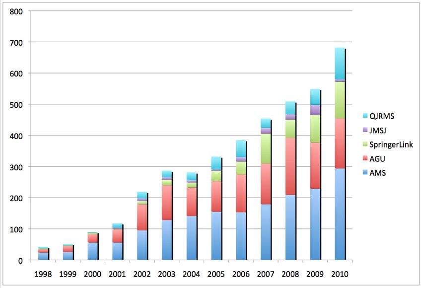
Tropical Rainfall Measuring Mission (TRMM)

31.6 rpm. The rotation draws a “circle” on the earth’s           any funds were directly allocated for TRMM data
surface.                                                         processing operations. Effective June 2008, TSDIS
                                                                 software was no longer maintained. Effective April
Visible and InfraRed Scanner (VIRS). The VIRS is a               2009, the TSDIS data product toolkit was replaced by
five-channel imaging spectroradiometer with bands in             the PPS toolkit. While this toolkit was substantially
the wavelength range from 0.6 to 12 µm. The VIRS data            untested in production and required major code changes
are used to obtain cloud information using visible and           for the algorithm developers, the change was necessary
IR techniques in order to provide a cloud context to the         so that programmers were not required to maintain the
microwave-based precipitation retrievals, and also a link        TSDIS toolkit and all toolkit activity could be subsumed
to rain estimation techniques and products derived from          under PPS support to GPM.
visible/infrared geosynchronous satellite data. The                    PPS is producing all the PR, TMI, VIRS,
VIRS has the same center wavelengths and bandwidths              combined instrument and multi-satellite standard
as the Advanced Very High Resolution Radiometer                  products. There has been little or no perceivable
(AVHRR) that has flown since 1978 on the NOAA                    degradation in instrument performance since launch.
series of spacecraft. The major differences between the          The PPS produces up to 12 GB/day of initial science
two systems are the 2.5-km nadir IFOV for VIRS in                data from the satellite. PPS gets the L0 (raw data with
contrast to 1.1 km for the AVHRR and the fact that the           effects of telemetry removed) from the Sensor Data
VIRS has an on-board solar diffuser for post launch              Processing Facility (SDPF). It uses the L0 data to
calibration of the two reflected solar bands.                    generate the starting level 1 processing (instrument
                                                                 counts reversible to L0). PPS personnel interact with the
Lightning Imaging Sensor (LIS). The LIS detects all              science team algorithm developers (including those in
(“total”) lightning, since cloud-to-ground, intracloud,          Japan) of L2 and L3 products to incorporate them into
and cloud-to-cloud discharges all produce optical pulses         the processing stream, ensure that they produce the
that are visible from space. The LIS consists of an              expected output and provide trending information for
optical staring imager, with a sampling rate slightly            analysis. All standard science products are sent to the
greater than 500 frames per second, which identifies             GSFC Distributed Active Archive Center (DAAC) for
lightning activity by detecting momentary changes in             distribution to the general public and for user support
the brightness of the clouds as they are illuminated by          for this group. PPS also has responsibility for
lightning discharges.      Due to the sensitivity and            reprocessing of TRMM data in the next year using the
dynamic range of the sensor, it can detect lightning             Version 7 algorithms. The reprocessing requirement is
during daytime even in the presence of bright, sunlit            to provide an additional 2X (24 GB additional) satellite
clouds. A wide field of view lens, combined with a               data reprocessing. Changes for V7 reprocessing are
narrow-band (10 A) interference filter, centered on a            currently being implemented by the algorithm
strong optical emission multiplet (OI (1) at 777.4 nm),          developers and PPS. Operational testing for V7
is focused on a small, high speed 128 × 128 element              algorithm code is under way and is expected to be
CCD array. The 80 deg × 80 deg angle field of view,              completed by May 1, 2011.
combined with the 400 km altitude, permit the sensor to                PPS also produces real-time versions of most of
view clouds within a 600 km × 600 km area of the Earth           the Level 2 products and the real-time multi-satellite
with a spatial resolution of 4 km (at nadir) for almost 90       analysis (TRMM Multi-satellite Precipitation Analysis
sec as TRMM passes overhead. The LIS data products               [TMPA], product designation: 3B-42RT). Indeed, an
are produced, archived, and reprocessed at and                   upgraded version of the TMPA was put into operation
distributed from the Global Hydrology and Climate                in February 2009. In addition to the standard products
Center in Huntsville, AL (http://thunder.msfc.nasa.gov).         provided to the wider community via an online archive,
                                                                 PPS also provides the opportunity for science team
2.1.3 TRMM precipitation data processing                         members to run more specific algorithms on the TRMM
                                                                 data, thus greatly reducing the data infrastructure
      The TRMM Science Data and Information System               required by individual PIs. The last hardware upgrade to
(TSDIS) was retired as the data processing system for            support TRMM processing was undertaken in 2008.
TRMM in June 2008. Given budget cuts received                          At the request of some PMM science team
virtually every year since 2005, it was no longer                members, PPS produces 0.25 by 0.25 deg gridded text
possible to maintain the software and the hardware for           products. These products are available online from the
the system. In June 2008, an early version of the                PPS TRMM server. In addition, a TIFF/world file
Precipitation Processing System (PPS), being designed            version of the TMPA real-time and production products
for the GPM mission, was implemented to assume                   were made available to GIS data users. The latter was
TRMM data processing. FY09 was the last year that                done as a prototype for the delivery of precipitation data
                                                                 in GIS compatible formats during GPM.

                                                             5
Tropical Rainfall Measuring Mission (TRMM)

      The continuation of the TRMM basic mission                  products (e.g., reflectivity volumes, brightness
means the continued production of the TRMM standard               temperatures, hydrometeor contents etc.) on convective
research products and real-time versions of these                 scales, and the creation of VHF-optical lightning
products. An improved Version 7 of these products will            proxies for use in testing and improving GOES-R
replace the current Version 6 in mid 2011. This level of          Geostationary Lightning Mapper algorithms.
data production is provided as in-kind support as part of
the PPS budget.                                                   2.1.5 Ground validation data processing
                                                                       A key component of the TRMM project is the
2.1.4 LIS data processing                                         Ground Validation (GV) effort (http://trmm-
                                                                  fc.gsfc.nasa.gov/trmm_gv). The GV effort is primarily a
      The LIS data processing chain includes ongoing              data collection and product generation program.
monitoring of LIS instrument health, instrument                   Ground-based radar, rain gauge and disdrometer data
command requests from MSFC to the GSFC Flight                     are collected and quality-controlled, and validation
Operations Team (FOT), transference of raw level 0 LIS            products are produced for comparison with TRMM
data from the GSFC TRMM Missions Operations                       satellite products. Detailed information and product
Center (MOC) to the LIS Science Computing Facility                analysis is available on the TRMM GV web site. The
(SCF), and further processing of level 0 data at the SCF          four primary GV sites are Darwin, Australia; Houston,
for product generation, quality control, archival and             Texas; Kwajalein, Republic of the Marshall Islands;
distribution.                                                     and, Melbourne, Florida (Wolff et al 2005). There is
      The processing of level 0 LIS data at the SCF is            also a significant effort being supported at NASA
conducted at the National Space Science and                       Wallops Flight Facility (WFF) to provide high quality,
Technology Center (NSSTC) in Huntsville, AL. It                   long-term measurements of rain rates (via a network of
includes the routine generation of high level LIS                 rain gauges collocated with National Weather Service
products (e.g., flash locations, flash optical properties,        gauges), as well as drop size distributions (DSD) using a
and various lightning climatology products). It also              variety of instruments, including impact-type Joss
includes the maintenance of the LIS processing                    Waldvogel, laser-optical Parsivel, as well as two-
algorithms and code responsible for generating these              dimensional video disdrometers. DSD measurements
high-level products. Note that the high level product             are also being collected at Melbourne and Kwajalein
orbit files are quality controlled, archived and                  using Joss-Waldvogel disdrometers. The list of GV
distributed. The Global Hydrology Resource Center                 products is given in Appendix A.
(GHRC) manages the archival/distribution services for                  The largest part of the validation effort involves the
LIS data with support it receives from the LIS budget.            routine, careful collection, processing and product
The GHRC, also located at the NSSTC, is a NASA EOS                generation of ground-based radar, rain gauge and
DAAC supporting the hydrological cycle. LIS data                  disdrometer data in order to produce standard validation
access is available from the following website                    products. Products are produced using techniques
http://lightning.nsstc.nasa.gov/data/index,          which        developed to carefully quality control ground radar data
indicates: “Data can be ordered free of charge from the           sets and estimate surface rainfall rates, adjusted by
GHRC through HyDRO, the GHRC's online data                        quality-controlled rain gauge data. The procedures for
ordering system, or by contacting the GHRC User                   performing these tasks are optimized to take advantage
Services     Office.”     The     HyDRO       website    is       of each site’s strengths. The primary radar data quality
http://ghrc.nsstc.nasa.gov/hydro/.                                control (QC) algorithm masks non-precipitation echoes
      As part of the archival and distribution services,          by use of adjustable echo-height and reflectivity
user community feedback is routinely gathered that                thresholds. Additional QC algorithms make use of
allows the LIS team to refine and evaluate existing               signal quality and semi-permanent ground clutter
products and to introduce new products of specific                sources (Silberstein et al. 2008). Rain gauge data QC is
relevance and importance. These activities motivate the           performed on several automated levels, one of which is
science tasks described in the LIS statement of work              a procedure to filter unreliable rain gauge data upon
(section 2.4.2). Moreover, because the LIS                        comparison to radar data (Amitai 2000). To ensure GV
observational time-series now extends beyond 13 years,            data products are of the highest possible quality,
it has attained significant statistical information content       dependent and independent rain gauge data (when
that allows for the creation of several more useful               available) are compared with radar estimates via scatter-
products for the science user community. Recent                   plot analysis. Further analyses include time series
examples include the creation of a higher spatial                 comparisons of gauge and radar rain rates and detailed
resolution      lightning     climatology      (to    0.25o       study of QC results. These efforts have resulted in
latitude/longitude bins), the creation of cell-scale              standard validation data sets, at both instantaneous and
databases which combine lightning and other TRMM                  monthly time scales, with which to compare TRMM-

                                                              6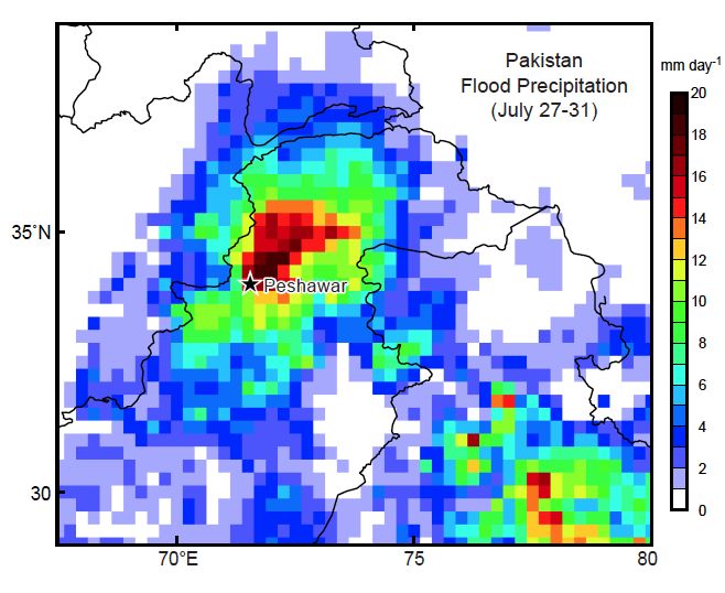
Tropical Rainfall Measuring Mission (TRMM)

based rain estimates, and have helped to establish the           important means to cross-validate microphysical
accuracy of the various TRMM products. In addition,              parameterizations in GPM Dual-frequency Precipitation
other specific gauge data sets are used to produce               Radar (DPR) and GPM Microwave Imager (GMI)
additional validation products.                                  retrieval algorithms (Chandrasekar et al. 2008).
     The TRMM GV program has made significant                    Analysis of KPOL data have shown that the quality of
accomplishments over the last several years.             A       its DP parameters are comparable to established
methodology to monitor and correct radar reflectivity            research radars, and are well suited for implementation
calibration using ground clutter area reflectivity               of QC, rain rate estimation, and hydrometeor
distributions, referred to as the Relative Calibration           classification algorithms (Marks et al. 2011).
Adjustment (RCA) methodology (Silberstein et al.                      GV products are used extensively by many groups
2008), is now fully operational and has provided near-           for validation research and published in peer-reviewed
real-time feedback to Kwajalein radar staff of any               journals (Fisher and Wolff 2011; Liao and Meneghini
possible issues with the Kwajalein radar. This RCA has           2009; Huffman et al. 2007; Marks et al. 2009, 2011;
the ability to detect and correct past changes in radar          Munchak and Kummerow 2011; Schwaller and Morris
calibration (±0.5 dB) and antenna elevation pointing             2011; Tokay and Bashor 2010; Tokay et al. 2010; Wang
errors (±0.1°), but is also prescient in detecting               et al. 2008; Wang and Wolff 2009, 2010; Wolff and
impending failures of the radar system. Application of           Fisher 2008, 2009). Munchak and Kummerow (2011)
the RCA to correct the historical data record for                used KPOL-derived DSD parameters to develop a
Kwajalein has salvaged a vital and irreplaceable climate         framework based upon optimal estimation theory,
precipitation record (12+ years) at this key oceanic GV          wherein three parameters describing the raindrop size
site. Through the use of dual-polarimetric (DP) data             distribution, ice particle size distribution, and cloud
from the Kwajalein radar (KPOL), an algorithm has                water path are retrieved for each radar profile to provide
been adapted to determine absolute reflectivity                  improved rain rate retrievals for the TMI and future
calibration by a self-consistency approach thereby               GMI. Liao and Meneghini (2009) used a decade long
verifying the RCA methodology. In addition, an                   record (1998-2007) of GV radar data from Melbourne,
automated QC algorithm based on DP observations has              FL, radar to assess the robustness of the TRMM PR
been adapted for the Kwajalein site. The DP-based QC             attenuation correction. Schwaller and Morris (2011)
application is statistically robust, and significantly           used TRMM GV data and QC algorithms to develop a
reduces labor-intensive processes needed when utilizing          prototype validation network over the southeast United
non-DP radars (Marks et al. 2011).                               States to support TRMM GV efforts, GPM pre-launch
     The Tropical Rainfall Measuring Mission (TRMM)              algorithm development, and eventually validation of
GV program was originally aimed toward a statistical             GPM space-based rain rate retrievals.
approach to precipitation retrieval validation; however,              TRMM GV members continue to work closely with
the current paradigm for both TRMM and future                    satellite product algorithm developers to help validate
missions, such as the Global Precipitation Measurement           and tune products, and also provide important input to
(GPM) program, will also employ physically based                 the land-algorithm working group for GPROF. TRMM
approaches to validate satellite observables and                 GV data is being used to provide validation for several
parameterizations. A key goal of this physically based           global precipitation products, such as TRMM 3B42
approach is to characterize the raindrop size distribution       (Huffman et al. 2007), the Climate Data Centers’
(DSD) of precipitation, as well as the microphysical             Morphing product (CMORPH, Joyce et al. 2004) and
structure of the precipitating system: e.g. the vertical         the Precipitation Estimation from Remotely Sensed
distribution of liquid, mixed-phase, and solid                   Information using Artificial Neural Networks
hydrometeors. With the recent advent and deployment              (PERSIANN), developed by Hsu et al. (1997).
of DP radars, it is now possible to provide estimates of              Because of the highly variable nature of
the key raindrop size distribution parameters                    precipitation, it is important to have high quality
(median/mass       weight    particle   diameters     and        validation data from a diverse variety of cases and
concentrations), at least within the rain (liquid) layers.       climate regimes over extended time periods. Therefore,
Additionally, use of polarimetric variables, such as             it is imperative for these products to cover many
differential reflectivity (ZDR) and specific differential        seasons and inter-annual variations in order to
phase (KDP) can be used to provide improved rain                 effectively sample the natural variability of precipitation
estimates, characterize the horizontal and vertical              and other characteristics with which to validate satellite
distribution of the various hydrometeor types, and               estimates. Further, long-term observations are necessary
characterize the height and depth of the mixed layer.            to provide robust validation of satellite estimates, given
From a physical validation perspective, the combination          the rarity of significant precipitation events at a given
of DSD parameter retrievals and hydrometeor                      site. Sub-setting and validating the data over land, coast
classification facilitated by DP radars provides an              and oceanic areas is needed for algorithm developers to

                                                             7
Tropical Rainfall Measuring Mission (TRMM)
tune their estimates over varying land surfaces. research (sections 2.2.1 through 2.2.3) and applications
Continuous validation is also important for monitoring communities (sections 2.2.4 and 2.2.5). One measure of
the health of the various satellite instruments, which TRMM’s contribution is the large number of refereed
might decay over the lifetime of the platform. For these publications that mention TRMM (Fig. 2). The TRMM
reasons, the TRMM GV program has continued to launch triggered a virtual flood of research that has led
collect and process data and should continue to do so in to significant improvements in our understanding of the
the future in synergy with the broader validation hydrologic cycle, of the climate system, and of tropical
program of GPM. weather systems and their prediction. The total of
TRMM-related research papers now numbers over
2.2 Summary of TRMM Accomplishments to Date 2000. A partial listing can be found at
http://trmm.gsfc.nasa.gov.
TRMM’s enormous success is related to its two A summary of TRMM’s scientific contributions in
unique attributes that make it ideal for observing various categories, with an emphasis on findings from
tropical rainfall systems: (1) its suite of complementary the past two years, is given in the following sub-
observing instruments and (2) its orbit characteristics. sections. TRMM’s original science goals have been met
TRMM provides a complementary suite of active and and many additional contributions have been made,
passive sensors flown on a single platform, providing beyond what was originally expected.
the most complete view of precipitation. Due to its
complement of instruments, TRMM has been called the 2.2.1 Climate-related research
“flying rain gauge”, i.e., the space standard for
precipitation observation. The TRMM observing system Rainfall climatology. TRMM’s new knowledge on rain
employs the only precipitation radar in space, the PR, distribution across the tropics has led to a benchmark
which provides the most direct method of observation of 13-year TRMM rainfall climatology (Adler et al.
precipitation and its vertical distribution (i.e., enabling a 2009), narrowing considerably the range of
three-dimensional view of precipitation). Efforts to uncertainty in previous space-based rainfall
resolve disagreements between precipitation estimates estimates. It provides unique monitoring of rainfall
from the PR and the passive microwave TMI are now at variations related to the stationary interannual ENSO
the point where TRMM’s potential to act as a global pattern (L’Ecuyer et al 2006; Arndt et al 2010) and the
rainfall reference standard is being utilized. Without the moving intraseasonal Madden–Julian oscillation (MJO)
PR in space, there will be no similar opportunity for pattern (Lau and Wu 2010, Waliser et al. 2009). Having
calibration with an active sensor until GPM is launched examined global and regional interannual variations of
in 2013. rainfall characteristics over the tropics, Nakazawa and
TRMM products are used extensively by the Rajendran (2009) showed that TRMM datasets detect
the interannual variation of rainfall in concert with OLR
and SST changes, which are closely tied to ENSO.
Using rainfall estimates from PR, Liu and Zipser (2009)
found that warm rain (cloud-top temperatures >0°C)
contributes 20% to total rainfall over tropical oceans
and 7.5% over tropical land. While categorizing
tropical convection into shallow, midlevel, and deep
clusters, Elsaesser et al. (2010) noted that each
contributes roughly 20%–40% in terms of total tropical
rainfall, but with mid-level clusters especially enhanced
in the Indian and Atlantic sectors, shallow clusters
relatively enhanced in the central and eastern Pacific,
and deep convection most prominent in the western
Pacific.
Fig. 2. Publication data show yearly totals broken
Diurnal cycle. TRMM has allowed the heretofore-
down by journal publisher. Totals are obtained by impossible quantification of the diurnal cycle of
searching publisher web sites for papers that
precipitation and convective intensity over land and
mention TRMM within the article text. Colors are as
ocean tropics-wide on fine scales (0.25°) (e.g., Nesbitt
follows: light blue, AMS; red, AGU, green, and Zipser 2003; Bowman et al. 2005; Hirose et al.
Springer-Link (e.g., Meteorology and Atmospheric
2008). In addition to studies characterizing the diurnal
Physics); purple, J. of the Met. Society of Japan; cycle on global scales, the continued accumulation of
cyan, Quarterly Journal of the Royal Met. Society. data has allowed for more studies of the diurnal cycle at
8Tropical Rainfall Measuring Mission (TRMM)
1999, 2006; Tao et al. 2004, 2006, 2010) for analysis
and comparison with global models. Recently, with the
help of extended PR convective/stratiform rainfall data,
improved Convective–Stratiform Heating (CSH)
algorithm-derived heating profiles were developed for
the global tropics (Tao et al. 2010). In addition, the
analysis of 13 years of TRMM data provides a baseline
climatology of the vertical structure of atmospheric
radiative heating in today’s climate and an estimate of
the magnitude of its response to environmental forcings
on weekly to interannual time scales (L’Ecuyer and
McGarragh 2010). Schumacher et al. (2008), Kodama
et al. (2009), and Takayabu et al. (2010) have conducted
studies of latent heating using the TRMM products.
Tropical dynamics. TRMM data has yielded new
insights into the dynamics of the tropical waves and
oscillation and hypotheses on the dynamics of
convective-climate feedbacks (Masunaga et al. 2006).
Using TRMM rainfall data, Lau and Wu (2010)
investigated the evolution of cloud and rainfall
structures associated with different phases of the MJO.
They note that the structural changes in rain and clouds
(Fig. 4) are consistent with corresponding changes in
derived latent heating profiles, suggesting the
importance of a diverse mix of warm, mixed-phase, and
ice-phase precipitation associated with low-level,
Fig. 3. a) Climatology (mm/day), b) standard congestus, and deep clouds. Combining the information
deviation among the TRMM climatology inputs, from TRMM latent heating profiles and rainfall rates,
and c) standard deviation/mean (%) for 10-year Zhang et al. (2010) argued that, contrary to general
TRMM composite rainfall during 1998-2007. The perceptions, radiative heating is more important than
standard deviation and standard deviation/mean latent heating in accounting for vertically propagating
are used as a measure of error or measure of tides that impose longitudinal variability on
mesosphere‐lower thermosphere winds, temperatures,
confidence in the climatology. [Adler et al.
(2009)] and densities. The long record of high-resolution SST
data from TMI allows investigations of tropical waves
regional scales including southeastern China (Chen et and oscillations on different time scales. Zhang and
al. 2009), Indochina peninsula (Takahashi et al. 2010), Busalacchi (2009) developed an empirical model for
India (Sahany et al. 2010) and western equatorial Africa surface wind stress response to SST forcing induced by
(Jackson et al. 2009). Studies have also focused on local tropical instability waves in the eastern equatorial
scales in central India, the southern Himalayan foothills, Pacific. Their model has applications for uncoupled
and the central Tibetan Plateau during summer monsoon ocean and coupled mesoscale and large-scale air–sea
periods (Singh and Nakamura 2009, 2010), and east of modeling studies.
the eastern Tibetan Plateau during the Mei-Yu season
(Xu and Zipser 2011), where the interaction of large- Impact of humans on rainfall. TRMM PR data have
scale circulation and local topography plays a key role. been used to identify rainfall anomalies possibly
associated with human impacts on the environment
Profiles of latent heating. TRMM products have (Lin et al. 2006). The unique combination of TMI, PR
provided the first comprehensive estimates of how and VIRS data has allowed for critical observations to
rainfall is directly related to latent heat release in the be made as to the relation between aerosols (including
atmosphere, a key characteristic in understanding the pollution), land-use change, and rainfall. L'Ecuyer et al.
impact of tropical rainfall on the general circulation of (2009) revealed that polluted clouds are more vertically
the atmosphere. Based on hydrometeor vertical developed than those in pristine environments, and at
structure information from PR, TMI, and model-based the same time act to suppress the formation of
cloud information, TRMM scientists have derived precipitation, evidenced by a trend toward higher liquid
climatologies of latent heating profiles (Olson et al. water path prior to the onset of light rainfall. Hand and
9Tropical Rainfall Measuring Mission (TRMM)
Fig. 4. Joint PDF of Tb and echo-top height over the equatorial western Pacific: (a) mean state of the eight MJO
phases and (b)–(i) the difference between the Joint PDF of each of the phases 1–8 (P1–P8) and the mean state.
Positive values are color shaded and negative values are in contours. The unit for the mean state is in 0.01% of
the total occurrence counts. For P1–P8, the unit is number of counts. (From Lau and Wu 2010)
Shepherd (2009) suggested that the TRMM rainfall convective system characteristics (e.g., horizontal
estimates may be used to examine rainfall modification size, depth, and intensity) which is very useful for
by urbanization on global scales and in parts of the searching and sorting historical rainfall events (Liu
world not well instrumented with rain gauge or radar and Zipser 2005). The CPF database has been used to
networks. Changes in rainfall and lightning resulting document the global distribution of tropical deep
from human activities are also studied for many convection (Liu et al. 2007), and to examine regional,
climatologically important regions as well as urban seasonal and diurnal variations of the rainfall
environments. Over the southeastern U.S. and nearby contributions from various precipitation features (Liu
Atlantic waters, summertime rainfall was found to be 2011). Seasonal variations of sizes and intensities of
significantly higher during the middle of the work week precipitation systems are found over the northeastern
than on weekends (Bell et al. 2008), which was related Pacific, Northern South Pacific Convergence Zone
to the regional climate-scale impact of aerosols from (SPCZ), and some land areas in addition to the well-
anthropogenic air pollution. An improved storm height known monsoon regions. A significant advantage of PR
analysis indicates that the probability of deeper storms data from other satellite-based rainfall measurements is
(7–15 km) are increased during the afternoon and that it provides not only spatial information on rainfall,
evening hours of midweek (Bell et al. 2009). but also vertical profiles of precipitation. Therefore, it
is frequently used to characterize the vertical
2.2.2 Convective systems and tropical cyclones structure of convective system in many
climatologically important regions such as South
Convective systems characteristics. America (Romatschke and Houze 2010), western
TRMM PR, TMI, VIRS, and LIS supply information for equatorial Africa and the adjacent Atlantic (Jackson et
a Cloud and Precipitation Feature (CPF) database, al. 2009), and the south Asia monsoon region
created by the University of Utah, that provides a (Romatschke and Houze 2011a, 2011b). Houze et al.
definitive climatology of the distribution of (2011) used TRMM data in an analysis of the
10Tropical Rainfall Measuring Mission (TRMM)
Fig.
5.
(a)
Topography
and
(b)-(f)
satellite
data
for
the
28
July
2010
Pakistan
rainstorms.
(b)
Infrared
satellite
image
(K)
from
METEOSAT
7
for
1530
UTC
28
July.
(c)-(f)
Reflectivity
from
the
TRMM
satellite
radar
in
dBZ.
(c)-(d)
TRMM
radar
overpass
at
15:31
UTC
28
July.
(e)-(f)
TRMM
radar
overpass
at
1709
UTC
28
July.
Horizontal
cross-sections
are
at
5
km
altitude.
Red
lines
in
(c)
and
(e)
indicate
the
locations
of
the
vertical
cross-sections
in
(d)
and
(f),
respectively.
devastating floods in Pakistan in 2010 (Fig. 5). Using basins during tropical cyclone season range from 3-
multiple years of TRMM data, convection has been 11%, with the maximum percentages in the eastern
characterized in regions where topography plays a Pacific near the Baja California coast, in the southern
critical role in the spatial and temporal distribution of Indian Ocean close to the Australian coast, and in the
precipitation, including the central Andes northwestern Pacific near Taiwan. Combining the
(Giovannettone and Barros 2009), central and southern TRMM multi-satellite precipitation product with
Mexico (Gebremichael et al. 2007), and the Tibetan MODIS and AIRS data and with NCEP global analyses,
Plateau (Li et al. 2008). Moreover, a daily soil analysis Braun (2010a) argued that the Saharan air layer, thought
(Gao et al. 2006) from TRMM provides an opportunity to be a positive factor to hurricane development by
to study the relations between convective initiation and some people but a negative factor by others, is not a
soil moisture and its gradient (Frye and Mote 2010). determinant of whether a tropical cyclone will intensify
or weaken in the days after formation. Both SST and
Tropical cyclones. Over the past decade, TRMM TMI rainfall data from TRMM are also often utilized to
and PR data have been heavily used by the National investigate the mechanisms responsible for the genesis
Hurricane Center (NHC) (Rappaport et al. 2009), of some extreme storms, e.g., hurricane Catarina, the
and have played an important role in the monitoring first hurricane ever recorded in the Southern Atlantic
and analysis of tropical cyclones (e.g., Blake and Ocean (Vianna et al. 2010).
Pasch 2010; Kimberlain and Brennan 2011). The data
have helped establish key characteristics of the Lightning climatology. The use of the lightning sensor,
distribution and variation of rainfall in tropical cyclones LIS, in conjunction with rain information has led to a
as a function of intensity, stage of development, and detailed global mapping of lightning distribution,
environmental conditions (Lonfat et al. 2004, Chen et quantifying the lightning/convection relation for
al. 2006). The ability of TRMM to see within cloud land and ocean (Petersen et al. 2005, 2006; Takayabu
systems enables it to detect the clouds within the 2006). Yoshida et al. (2009) suggested that the number
inner regions of topical cyclones. It aids the analysis of lightning flashes per second per convective cloud is
of clouds and precipitation associated with the different related to cold‐cloud depth (the height above the 0º C
parts of tropical cyclones including the eyewall and the level) and that this relationship has little regional
rainbands beyond the eyewall region (Houze 2010). dependency. At regional scales, seasonal variations of
Jiang and Zipser (2010) estimated that the contribution lightning activity in precipitation systems over south
of tropical cyclones to the total rainfall over six oceanic China exhibited higher probabilities of lightning and
11Tropical Rainfall Measuring Mission (TRMM)
higher flash rates before the onset than during the first time a TMI algorithm that incorporates information
mature phase of the Mei-Yu season (Xu et al. 2010). from the PR (Kummerow et al. 2011). In developing a
Ten years of LIS data were used to generate higher database of cloud profiles for passive microwave
resolution lightning climatology maps (Albrecht et al. retrievals that is based upon the PR-measured profiles,
2009), identifying more localized features of lightning Munchak and Kummerow (2011) presented a retrieval
activity. Post-TRMM-boost data have been used to framework based upon optimal estimation theory
explore the relationship between tropical cyclogenesis wherein three parameters describing the raindrop size
and global easterly wave phenomena (Leppert and distribution, ice particle size distribution, and cloud
Petersen, 2010, 2011). In addition, extensive aircraft water path are retrieved for each radar profile. In
measurements of lightning and thundercloud currents addition to research related to the facility algorithms,
can now be combined with LIS (and Optical Transient work has also progressed on experimental algorithms.
Detector, OTD) data to make modern estimates of the so Varma and Liu (2010) proposed an algorithm to better
called Carnegie Curve that characterizes the global classify convective/stratiform rain in those rain events
electric circuit based on the LIS climatology and an with small area coverage compared to the TMI pixel
existing fixed database of aircraft electrical size. Liao et al. (2009) described a brightband model,
measurements (Mach et al. 2009; Mach et al. 2010; having the potential to be used effectively for both radar
Mach et al. 2011). and radiometer algorithms, allowing the fractional water
content to vary along the radius of the particle.
Lightning and chemistry. Knowledge of flash energy
and flash type (ground flash or cloud flash) is crucial for Multi-satellite analyses. With the TRMM satellite
better determining lightning nitrogen oxides (NOx) producing the best instantaneous rain estimates, those
emissions. Through ground validation, radiative estimates have been used to calibrate or adjust rain
transfer modeling, and regional air quality model estimates from other satellites to provide analyses at
implementation studies, progress has been made in higher time resolution than available from one satellite
better understanding the value of LIS data for estimating (Adler et al. 2000). The TRMM multi-satellite
lightning flash energy and for discriminating lightning precipitation analysis (TMPA) provides a
flash type (Solakiewicz and Koshak 2008a,b; Koshak et calibration-based sequential scheme for combining
al. 2009; Koshak 2010; Koshak 2011; Koshak and precipitation estimates from multiple satellites, as
Solakiewicz 2011). In particular, the study by Koshak well as gauge analyses where feasible, at fine scales
(2011) introduces a mixed exponential distribution (0.25° × 0.25° and 3 hourly) (Huffman et al. 2005,
model that can be used to retrieve the ground flash 2007). The TRMM multi-satellite rainfall products are
fraction in a set LIS-observed flashes; this represents now being used for a variety of important studies,
the first attempt to divide the total lightning distribution including validation of meteorological reanalyses
into two distributions: one for the ground flashes and (Fernandes et al. 2008), hydrologic modeling (Tobin
one for the cloud flashes. LIS data are also useful for and Bennett 2010), analysis of oceanic precipitation
identifying lightning generated NOx and investigating systems (Skok et al. 2009), characterization of monsoon
rain-induced soil NOx emission (Bucsela et al. 2010; convection (Xu et al. 2009), closure of water budgets
Ghude et al. 2010). (Sheffield et al. 2009), as well as for other
hydrometeorological applications (Tao and Barros
2.2.3 Measurement advances 2010).
Improvement of algorithms. Comparison of TMI and Intercomparison with other satellite-based estimates and
PR rain rates has led to increased understanding of ground-based measurements. Given the 13-year long
differences between, and therefore improvements to, record of TRMM, it is now possible to provide
these retrievals and those for all passive microwave quantitative comparisons between TRMM rainfall data
sensors (Berg et al. 2006; Masunaga and Kummerow and ground-based measurements on global and regional
2005, Shige et al. 2008). In preparation for a new scales (e.g. Wang and Wolff 2009; Wolff and Fisher
version of TRMM products, i.e., version 7 of the 2009; Gourley et al. 2010). The intercomparison efforts
TRMM algorithms, TRMM scientists have examined are carried out in many countries around world
causes of possible bias in the current algorithms and including, for example, Brazil (Franchito et al. 2009),
have made resulting improvements. Additional China (Shen et al. 2010), Ethiopia (Hirpa et al. 2010),
improvements, guided by observational and modeling India (Rahman et al. 2009a), Italy (Villarini 2010), and
studies, have been implemented in the V7 rainfall Korea (Sohn et al. 2010). On the one hand, TRMM data
products for the PR (Iguchi et al. 2009, Kozu et al. are used for ground radar calibration (Schwaller and
2009), TMI (Gopalan et al. 2010), and TMPA (Bolvin et Morris, 2011) and to provide high-resolution rainfall
al. 2010). In particular, the V7 data will feature for the information for coarse-resolution rain-gauge networks
12You can also read