(UKPAF) UK Postal Address Finder - User Guide - Mendip Data Systems - Version 3.46
←
→
Page content transcription
If your browser does not render page correctly, please read the page content below
Mendip Data Systems

              UK Postal
            Address Finder
              (UKPAF)

                   User Guide
                    Version 3.46

Colin Riddington               Updated 26/05/2018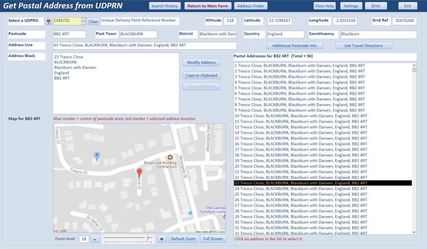
Contents
1.         Using the Application .......................................................................................................................................3

2.         Main form ........................................................................................................................................................4

3.         Postcode Address Search.................................................................................................................................5

4.         Search History ..................................................................................................................................................9

5.         Location Finder ..............................................................................................................................................10

6.         Nearby Place Search ......................................................................................................................................13

7.         Address Finder ...............................................................................................................................................17

8.         UDPRN to Address .........................................................................................................................................18

9.         Route Planner ................................................................................................................................................19

10.        Signature Capture ..........................................................................................................................................21

11.        Postcode Info .................................................................................................................................................22

12.        Postcode Summary Reports...........................................................................................................................23

13.        Help ................................................................................................................................................................23

Appendix A – UK Postcodes ........................................................................................................................................24

Appendix B – Program Updates..................................................................................................................................25

Appendix C - Possible Issues .......................................................................................................................................27

Page 2 of 27                                          UKPAF User Guide – Version 3.46                                                                  29/05/2018
UK Postal Address Finder (Version 3.46)
UK Postal Address Finder (UKPAF) is an Access database application which has been created to import
postal address data and postcode maps from online sources directly into Access
There are three versions of the application. The main features in each version are shown below:
Feature Standard Professional Tablet
Full list of addresses from postcodes
Postcode search history
Postcode map
Additional postcode information
Location finder
Postcodes from geolocation
Nearby Places Search
Full address finder from partial address
Address from UDPRN
Route Planner
Signature Capture
Postcode Info
1. Using the Application
The UK Postal Address Finder application is run using a desktop shortcut
When the application starts, a splash form will appear briefly.
This will perform various checks then close automatically
This may be followed by a start form (unless this was disabled by program administrators)
Normally the main form appears after the splash form closes
Page 3 of 27 UKPAF User Guide – Version 3.46 29/05/2018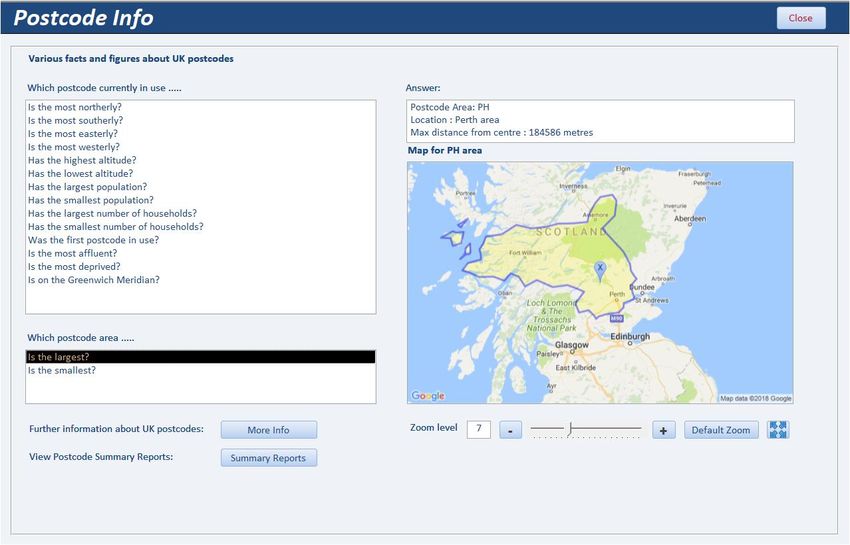
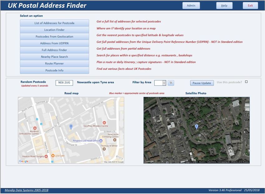
2. Main form
This is used to access the main features of the UK Postal Address Finder (UKPAF) application
The form provides access to all program features including:
Postal address search & map
Location finder – find a place by postcode area, district & sector
Postcodes from Geolocation – get the nearest postcodes to the current (or other) location
Nearby Place Search – find places of specified types within a set radius
Postcode search history
Address Finder – full addresses from partial addresses
Detailed Postcode Info (Standard / Professional versions only)
Address from UDPRN (Professional / Tablet versions only)
Daily itinerary (Professional / Tablet versions only)
Route Planner (Professional / Tablet versions only)
Signature capture (Professional / Tablet versions only)
Postcode Info – facts & information about UK postcodes together with summary reports
Help – UKPAF User Guide
Admin Menu – for program admin users only
The form also shows a map and satellite photograph for a randomly selected postcode.
These are both updated every 5 seconds.
Click the button to pause the update at any time.
The displayed postcode can be selected for use in postal address & nearby place searches
Page 4 of 27 UKPAF User Guide – Version 3.46 29/05/2018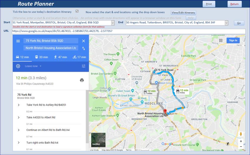
3. Postcode Address Search
     This is used to obtain a list of postal addresses and a map for selected postcodes
     The form normally opens to the default postcode (this will have been setup by program administrators)

                                                                                                                    1
                                                      2

                                                                                    4

               3
               5
                                                                              5

     The main form contains a lot of information and it may be easier to consider this in 5 sections:

     1.   Links to other items (described later)
     2.   Postcode selection and summary information
     3.   List of postal addresses for the selected postcode
     4.   Address block and various tools for a selected address
     5.   Map for the selected postcode with zoom controls and full screen mode

     New postcodes can be entered in three different ways:
     a) If you know the postcode it can be typed directly into the postcode textbox at the top left

          It will automatically be changed to upper case and a space added as is standard for UK postcodes

     b)   Click the small filter button to the left of the postcode box. The display will change to show a yellow
          combo box with all postcodes previously used with the application.

          Select any postcode from the list shown

          Click the filter button again to return to the standard textbox entry
     c)   Click the small Wizard button to the right of the postcode box.
          This will open a new Postcode Builder form – useful if you are unsure which postcode you require

Page 5 of 27                        UKPAF User Guide – Version 3.46                                 29/05/2018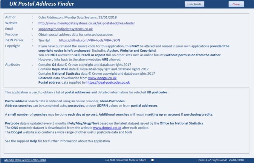
This tool allows you to build a postcode from its components: area, district, sector and zone
Area, District & Sector are official postcode terminology.
Zone is an extra descriptor used by this application
For more information about postcodes, see Appendix A
Click the OK button to start using the postcode builder
A dropdown box appears with a list of postcode areas. Select an area from the list
Another dropdown list then appears with a list of districts for the selected postcode area.
Further dropdown lists appear in turn until you have selected a full postcode
The lists will only include valid postcodes that are currently in use
Once you have selected a postcode, click the Confirm button.
You will then be returned to the postal address form.
Page 6 of 27 UKPAF User Guide – Version 3.46 29/05/2018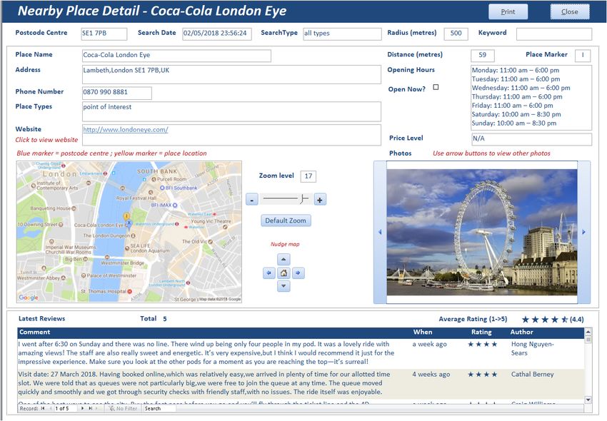
A full list of addresses for the selected postcode will be displayed together with a map.
          A blue marker indicates the postcode centre

          NOTE:
          If the address has previously been used, the addresses will be retrieved from the database itself.

          Otherwise, an online search is done and the addresses are downloaded and saved
          Each online search uses 1 credit and costs about 3p (£0.03)

          If the list appears to be incomplete, click the Update List button to run the online search again

          Geolocation data is displayed for the postcode: latitude / longitude / OS Grid Reference / Altitude
          Other location data such as town / county etc are also shown. Some items may be blank

          NOTE: Less data is available for postcodes in the Isle of Man (IM) , Guernsey (GY) and Jersey (JE)

          Select an address from the list on the left
          The map will be updated and centred on the selected address - shown with a red marker.

Page 7 of 27                        UKPAF User Guide – Version 3.46                                   29/05/2018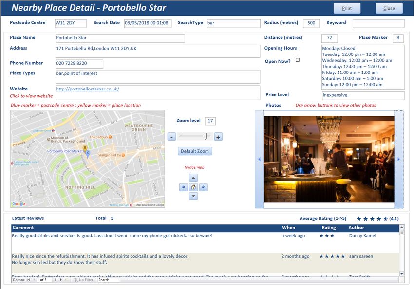
You can use the zoom in / out controls or the slider to adjust the level of detail shown on the map.
          The default zoom level is 17 with a range = 1 (whole Earth) to 20 (rooftop).

          The small button with 4 blue arrows is used to open a full screen online ‘live’ map

          The full address is shown as an address block which can be used on envelopes or in other programs.

          Clicking the Modify Address button adds an extra line at the top of the address
                 e.g. for entering the householder’s name

          Click the Copy to Clipboard button so the address can be pasted into another application

          The UDPRN (Unique Delivery Point Reference Number) for the address is also shown.
          As the name indicates, this is used to deliver items to the correct postal address
          Double click the UDPRN to add this to the address block. Double click again to remove it

          If you have the Professional or Tablet editions of the program, you can click the Add to Today’s
          Itinerary button to select an address as part of the Route Planner feature - see section 9
          This feature is NOT available in the Standard edition

          The View Nearby Places search feature is described in section 6

          Click the Additional Postcode Info button for many other items of information for the selected postcode

        NOTE: the Additional Postcode Info feature is NOT available in the Tablet edition for reasons of space

        Use the Clear button to empty the Postcode box
        Click the Get Default button to enter the default address as set by program administrators
        The Set Default button is only available for program administrators

        The Print button opens a report showing the addresses list and the postcode map

Page 8 of 27                        UKPAF User Guide – Version 3.46                               29/05/2018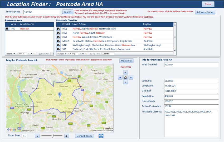
4. Search History
     The Search History button opens a report listing all postcodes already used by the application.
     Postal addresses for each of these postcodes have been saved in the database for future use.

Page 9 of 27                       UKPAF User Guide – Version 3.46                               29/05/2018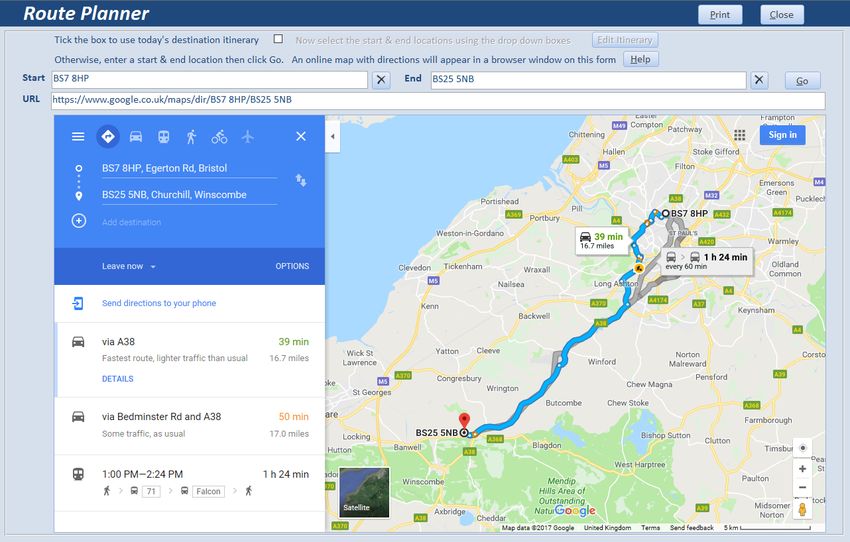
5. Location Finder
     The Location Finder can be used to pinpoint an exact location on a map and determine its postcode

     NOTE: For a street location, use the Address Finder feature instead – see section 7

     Enter a place name or postcode area / district in the search box e.g. Harrow
     All postcode areas and districts matching the search will be displayed with the search item highlighted in RED

     Click the View button        next to any item to view a static map and details about the item

     For example, the postcode area HA has been selected below
     A blue line marks the area boundary and a blue marker indicates the centre of the postcode area

     The zoom level will be automatically updated depending on the size of the postcode area

     Use the zoom tools to increase / reduce the map magnification.
     A full screen ‘live’ map can also be viewed (but it will not include the boundary line)

     Use the nudge tools to move the map by small increments and the home button to restore the original map

Page 10 of 27                       UKPAF User Guide – Version 3.46                              29/05/2018
You can drill down to postcode district level by clicking one of the View buttons in the postcode district list
For example, postcode district HA1 has been selected below.
The map and information are both updated for the selected postcode district.
The zoom level will be automatically updated depending on the size of the district
In addition, a list of postcode sectors is now displayed for that district
Tick the Show Sectors checkbox to show the approximate centre of each sector (RED markers)
Page 11 of 27 UKPAF User Guide – Version 3.46 29/05/2018You can now select any of the sectors displayed in the right hand list to view a sector map
For example postcode sector HA1 3
Once again the map and information will be updated for that sector
In addition a list of all postcodes in that sector will be displayed
The final level of detail is available by selecting any postcode from the list
The postcode centre is shown with a GREEN marker
NOTE: boundary lines for individual postcodes are not currently available
Click the View Nearby Places button to view places in the near vicinity of the selected postcode
(see Section 7)
Page 12 of 27 UKPAF User Guide – Version 3.46 29/05/20186. Postcodes from Geolocation
This is used to obtain your current geographical location on a map and determine the nearest postcodes
The easiest way to obtain the current geolocation data is to click the 'Get Current Location' button
A message will appear:
Click OK to load a map of the UK in a browser window
Click the Allow Once button within 3 seconds to grant permission for your current location to be located
The latitude and longitude data will be obtained and saved on the main form
NOTE:
1. Location services MUST be ENABLED in Windows settings to use this feature (Windows 7 or later)
2. The result will only be accurate if your PC contains a geo-sensor.
These are found in all tablets, most laptops and some desktop PCs
If no geo-sensor is available, the location will be estimated based on mobile phone, wi-fi or ISP data
In such cases, the accuracy of the quoted location may be poor.
3. A bug in Windows 10 version 1803 update has temporarily ‘broken’ the geolocation service
This has been reported to Microsoft and a fix will follow at some point
Page 13 of 27 UKPAF User Guide – Version 3.46 29/05/2018Alternatively, do one of the following to obtain your current geolocation data:
i) Open Google maps to your current location
ii) Use GPS data from a mobile phone or other device with a geo-sensor
iii) Use a Windows app such as Sensor List or Geolocator (free from the Windows Store)
iv) Take a photo using your PC webcam then use the GPS data from the photo properties
Enter the latitude & longitude for your current (or another) location and click the Search button
A database search will locate the closest postcodes and show these on a map.
Each postcode location is displayed with a GREEN marker
As over 2.6 million postcodes need to be searched, this process will take a few seconds
Select a postcode from the list to use that postcode with other application features:
View Nearby Places – see section 7
Postal Address List – see section 3
Route Planner – see section 9
Page 14 of 27 UKPAF User Guide – Version 3.46 29/05/20187. Nearby Place Search
This feature is used to view a list of places of a specified type within a set radius of a selected postcode.
The postcode may already have been entered depending on how you accessed this form.
Alternatively, enter a postcode using the wizard button
Next select:
a place type from the list (or use the default ‘All Types’)
the required search radius from the postcode centre (default = 500 metres)
one or more search keywords (optional)
A list of up to 20 places nearby will be displayed together with a map centred on the postcode.
The map includes yellow markers for each of the nearby places listed
The map scale will be automatically updated depending on the search radius (range 100 -> 5000m)
Page 15 of 27 UKPAF User Guide – Version 3.46 29/05/2018Double click any place in the list to view further details about the selected place
The place detail form opens. Depending on the place selected, details shown may include:
full address, telephone, website, one or more photographs
opening hours and price level, up to 5 recent online reviews with ratings (1-5 scale)
Use the arrow buttons to view additional photographs for the selected place
Page 16 of 27 UKPAF User Guide – Version 3.46 29/05/20188. Address Finder
The Address Finder feature is used to obtain a list of suggested addresses from a partial address.
Up to 100 results can be obtained. The initial search suggestions are free.
Results include the street and postcode district, together with the UDPRN
Enter a partial address e.g. street and town or house number and street then click Search
The more precise the input, the better the suggestions will be.
In the example shown below, the partial address Hill Street was entered
The suggestions also include Strawberry Hill in the town of Street
A more focused search such as 26 Hill Street or Hill Street ST4 would give fewer false positive results
The list of suggested addresses can be printed as a report
Select any address in the list to get the full address block and an online map
Doing this uses 1 credit.
Click Return to return to the main address form.
A message similar to this will then be displayed
If you select Yes, another online search will be run to obtain all addresses for this postcode.
As before, doing this will require 1 credit
Page 17 of 27 UKPAF User Guide – Version 3.46 29/05/20189. UDPRN to Address
Available in Professional / Tablet editions ONLY
This feature is used to get the full address from the Unique Delivery Point Reference Number (UDPRN)
Type the UDPRN into the textbox or click the small filter button to select from UDPRN values which were
obtained from previous searches
An online search will be run and all postal addresses found for the related postcode for this UDPRN
The controls on this form are very similar to those on the Main and Address Finder forms
Page 18 of 27 UKPAF User Guide – Version 3.46 29/05/201810. Route Planner
Available in Professional / Tablet editions ONLY
This form is used to get travel directions between any two selected locations
You can use any of the following for the start and end locations:
Postcode
Full or partial address
Co-ordinates (latitude & longitude)
In the example shown below, two postcodes have been entered.
When the Go button is clicked, an online route map and directions are displayed (this is free)
In addition, you can use any addresses previously added to the itinerary for the day.
To do so, click the checkbox at the top of the form
Then click the View/Edit Itinerary button
The list of addresses in the daily itinerary is then displayed.
Page 19 of 27 UKPAF User Guide – Version 3.46 29/05/2018The order can be modified using the buttons on the right
Click the All Done button when the list order is correct
Next select one of the addresses from the dropdown Start box
The next address in the list is automatically entered in the End box (though this can be changed)
As before, an online route map and directions are then displayed
The route planner map and directions can be printed as a report
Page 20 of 27 UKPAF User Guide – Version 3.46 29/05/201811. Signature Capture
Available in Professional / Tablet editions ONLY
This feature is for use when using the tablet edition for delivery systems based on the daily itinerary
Double-click the Start or End location on the Route Planner form
The Customer Signature form appears with the address already entered.
Enter the name of the person providing the signature
The customer can enter their signature using a:
finger or stylus on a touchscreen
trackpad or mouse on other systems
The date and time are added automatically when the Save button is clicked
The signature is saved as a GIF image file in the Signatures folder.
It can be viewed in any Images application including Paint
The file name will be similar to this example: Sig_13_Fred Smith_20171208_013956.gif
The file name includes the:
signature ID value (13)
customer name (Fred Smith)
date and time in the format yyyymmdd hhnnss
Click Close to return to the Route Planner form
Page 21 of 27 UKPAF User Guide – Version 3.46 29/05/201812. Postcode Info
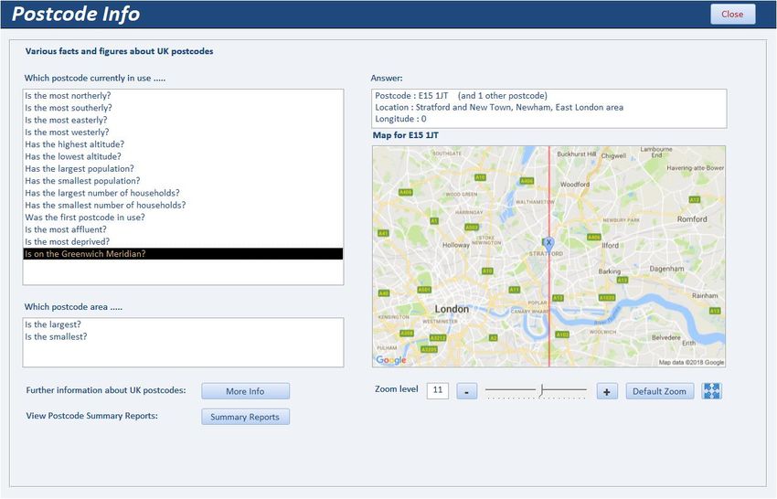
This feature is used to find out various facts and figures about UK postcodes
For example, which UK postcode:
is the furthest north/south/west/east
has the highest/lowest altitude
largest / smallest population and number of households
is the most affluent / deprived etc
The form also contains links to:
additional information about the UK postcode system (identical to Appendix A)
postcode summary reports (see Section 12)
Page 22 of 27 UKPAF User Guide – Version 3.46 29/05/201813. Postcode Summary Reports
Clicking the Summary Reports button on the main form opens this dialog box
Each button opens a report – most have MANY pages.
The final two postcode reports have around 37400 & 55400 pages
Please THINK before printing!
14. Help
The Help button opens this User Guide
Page 23 of 27 UKPAF User Guide – Version 3.46 29/05/2018Appendix A – UK Postcodes
Postcodes were introduced to the United Kingdom by the Royal Mail between 1959 and 1974.
There are approximately 2.6 million postcodes in the UK with around 1.8 million currently in use.
On average each postcode contains about 15 addresses.
Typically a full postcode represents a street, a part of a street or a small village.
However, a number of postcodes are non-geographic with no physical addresses
The format of a UK postcode is always one of the following where L represents a letter, and N a number
LN NLL
LLN NLL
LNN NLL
LLNN NLL
LLNL NLL
LNL NLL
Postcodes are made up of outward and inward sections separated by a space
Outward Inward
BS7 8HP
The outward part is used by the Post Office to send mail to the correct regional sorting office.
It has 2 parts:
Area - usually 2 letters (in this case BS for Bristol) with exceptions such as M (Manchester)
District – area normally followed by a one or 2 digit number e.g. BS7
The inward part is used to sort mail into individual delivery rounds from the destination sorting office
This always contains 3 characters comprising:
Sector – district followed by a single digit number (in this case BS7 8)
Zone – sector followed by a letter (BS7 8H)
A final letter to give the full postcode
The inward code never contains the letters C, I, K, M, O, V to reduce possible risk of confusion with other
characters when hand-written
NOTE:
Area, District and Sector are all official postcode terminology.
Zone is an extra descriptor used within this application
Special Postcodes
Non – geographic codes are often used for PO boxes and direct marketing.
For example all postcodes in area BX and those beginning with EC50, BS98, SW99
Other examples include:
Girobank (GIR 0AA)
DVLA (all codes starting with SA99)
All letters to Santa Claus (XM4 5HQ) !
Some British overseas territories also use UK postcodes. For example:
Gibraltar GX11 1AA
Falkland Islands FIQQ 1ZZ
British Antarctic Territory BIQQ 1ZZ
Further info: https://en.wikipedia.org/wiki/Postcodes_in_the_United_Kingdom
https://www.mjt.me.uk/posts/falsehoods-programmers-believe-about-addresses/
Page 24 of 27 UKPAF User Guide – Version 3.46 29/05/2018Appendix B – Program Updates
Periodically, new versions of the UK Postal Address Finder program will be supplied with performance
improvements and additional features. Upgrades are normally very quick and easy to install.
When users log into the program, it checks that the latest version is installed.
This is done using the small utility file, UKPAFUpdater.accdb, located in the same folder as the main program
file. This is the splash screen seen when UK Postal Address Finder is started:
If the current version is up to date, the main program file is loaded:
If a newer version is available, the updated files are copied from the Upgrade folder to the user’s
computer.
A green progress bar may be displayed whilst this happens
Page 25 of 27 UKPAF User Guide – Version 3.46 29/05/2018This should normally take less than 10 seconds to complete and is followed by a message similar to this:
Click OK to relink the tables as in the initial program setup
In the unlikely event of problems, run the upgrade again using the Force Update button.
For example, if any program files are open when the upgrade is running, this message is shown:
Page 26 of 27 UKPAF User Guide – Version 3.46 29/05/2018Appendix C - Possible Issues
Like any complex application, issues may occur from time to time.
The following explains some issues you may experience and possible solutions / work rounds:
Issue Possible Causes Suggested Solution / Work round
Problems during new Various issues depending on individual Recover files to default state & try
installation or version user setup running the process again
update See Appendix C for details
Activation code not Activation code wrongly entered Check & re-enter
accepted Code entered on another PC Enter activation code on same PC used
for activation request
Activation email could not Required information missing Complete missing information
be sent
A feature isn’t available Certain features are not available in Upgrade to the professional edition
the standard or tablet editions
See feature list in Appendix A
Cannot open application Database is LOCKED for maintenance Wait for program admin needs to
unlock application
Concurrent user limit reached Wait for another user to exit
Purchase additional licences or a site
licence
Slow performance Poor network connection Check network
Error message related to ActiveX controls are disabled in Access Open Access Options in File menu, then
hidden Active X zoom Trust Centre Options Trust Centre ActiveX settings. Change
slider control on main the setting from disabled to any other
form setting. See Appendix E for more details
Address data cannot be No internet connection Check internet connection
downloaded Postcode account not setup Create an ideal postcodes account
Postcode account credit limit reached Purchase additional credits
Postcode not listed Postcode invalid or not in current use Check postcode is valid / in use
Newly issued postcode e.g. for new Download the latest postcodes dataset
houses from the Mendip Data Systems website
(updated every 3 months)
Postcode maps cannot be No internet connection Check internet connection
downloaded Google Maps API not valid Get your own Google Maps API key
Very large scale use of Google maps Check for excessive usage
may be ‘throttled’
Geolocation data cannot No internet connection Check internet connection
be obtained Location services disabled Enable this in Windows settings
Windows 10 1803 update installed and Use a GPS enabled device e.g. mobile
the geolocation service has failed phone and enter data manually
Geolocation data is Geo-sensor not fitted to the computer Use a GPS enabled device e.g. mobile
inaccurate phone and enter data manually
Nearby places data No internet connection Check internet connection
cannot be downloaded No places of specified type within set Modify nearby places search type or
radius distance
Google Maps API not valid for Places Get your own Google Maps API key &
data enable Places API
Please email support@mendipdatasystems.co.uk to alert us if you experience any other issues.
Page 27 of 27 UKPAF User Guide – Version 3.46 29/05/2018You can also read