Last Updated: September 4, 2018 - National Weather Service
←
→
Page content transcription
If your browser does not render page correctly, please read the page content below

Last Updated: September 4, 2018

                                  https://www.weather.gov/chs/
Welcome to the latest Hurricane Guide
from your National Weather Service in
Charleston, SC!
This guide will help you:
prepare for hurricane season
stay informed of the latest tropical
cyclone threats
stay safe during a hurricane
learn about local tropical cyclone
history
NOTE: Numerous links (in blue) are provided throughout this guide to obtain more information!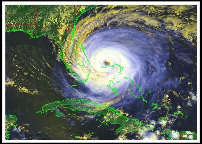
Outline Tropical Cyclone Hazards Being Prepared and Staying Informed Tropical Cyclone Basics Tropical Cyclone Climatology Tropical Cyclone History for Southeast South Carolina and Southeast Georgia
Main Tropical Cyclone Hazards
Storm Surge Terminology Storm surge: abnormal rise of water generated by a storm Storm tide: storm surge + astronomical tide Inundation: height/depth of water above the ground
Storm Surge Facts
Greatest threat to life and property
along the coast
Can occur rapidly and forcefully and
travel many miles inland in low-lying
areas (such as along the SC/GA coasts)
Produced mainly by strong winds
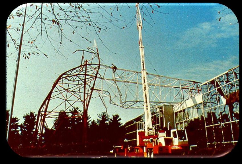
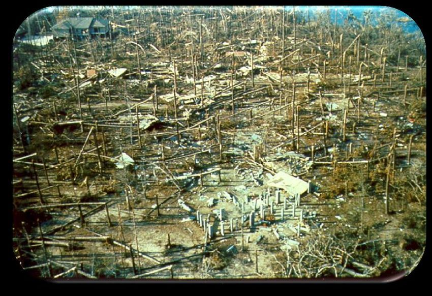
blowing over the ocean for an Isle of Palms, SC after Hurricane Hugo (1989)
extended period
Stronger, larger and faster storms
generally produce higher surge
The amount of surge is not solely
dependent on the storm category
Highest surges at the coast typically
occur to the right of where the center
of the storm comes ashore (blue area
outlined in the image to the right)
« Images courtesy of NWS
Storm Surge Facts There will be more flooding if the highest surge occurs around high astronomical tide (compared to low tide) The coastal areas of SC/GA are very surge-prone given the low elevation and gently sloping continental shelf offshore In 1989, Hurricane Hugo produced the highest water levels ever recorded on the U.S. East Coast (~20 foot storm tide above Mean Sea Level at Bulls Bay, SC and ~10 foot storm tide above MSL in downtown Charleston, SC) « Images courtesy of NWS Romain Retreat, SC (near Edisto Beach, SC after Bulls Bay) after Hugo (1989) Matthew (2016)
Storm Surge Impacts

   Folly Beach, SC – before Hugo      Folly Beach, SC – after Hugo

                                   Hurricane Ike (2008):
                                   - Category 2
Hurricane Ivan (2004):
                                   - 15-20 foot surge
- Category 3; 10-16 foot surge
                                                           «   Images courtesy of NWS
Are You At Risk From
Storm Surge?
If you live in/near any of the shaded areas on the maps on
the next few slides you are vulnerable to storm surge!
Check out NOAA’s storm surge hazard maps
Determine whether you are in an evacuation zone... SC /
GA
Evacuate if advised to do so by local authorities!
Keep in mind that if you don’t evacuate, your location may
become an “island” cut off from emergency officials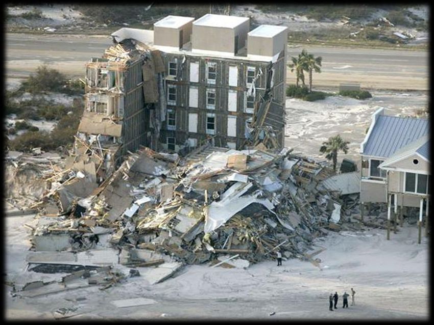
Local Storm Surge Risk
Approximation
                    Southern South Carolina Coast
of the “worst
case”
inundation (i.e.,
amount of
water above
ground) for a
hurricane in this
area. Note how
far inland the
storm tide can
reach, mainly
near low-lying
rivers and
creeks. For any
particular
location, the
greatest
inundation
normally occurs
with a
landfalling
storm just south
of that area.
Local Storm Surge Risk
Approximation
Northern Georgia Coast
of the “worst
case”
inundation (i.e.,
amount of
water above
ground) for a
hurricane in this
area. Note how
far inland the
storm tide can
reach, mainly
near low-lying
rivers and
creeks. For any
particular
location, the
greatest
inundation
normally occurs
with a
landfalling
storm just south
of that area.High Winds
Strong, damaging winds can occur hundreds of miles from
the coast
In fact, Hurricane Hugo in 1989 produced hurricane force
wind gusts in Charlotte, NC toppling numerous trees and
power lines (see image to the left below)
Beaufort County, SC after
Hurricane Matthew (2016)
« Images courtesy of NWSHigh Wind Facts
Generally the stronger the storm at landfall the longer it
will take for the winds to diminish
Coastal areas/high-rise buildings:
winds normally higher due to less surface friction
Inland areas away from the immediate coast:
sustained winds generally lower than at coast, but gusts can
be similar to sustained winds at coast
« Images courtesy of NWS
Charleston Area After
Hurricane Hugo (1989)High Wind Safety Cover all windows and doors with plywood or shutters Do NOT leave any windows/doors open to relieve pressure Tape does NOT work! Reinforce garage doors as they are typically weak points Store all outdoor items that could become deadly missiles Evacuate to a more sturdy structure if you live in a mobile/manufactured home, especially if advised to do so by local authorities During a storm, go to your “safe place” which should be the most interior room on the lowest floor of your building that is not prone to flooding and protect your head with helmets or pillows
Flooding Rainfall
When you think “hurricane”, think
“flooding”!
Most deaths in recent tropical cyclones have been
from inland fresh water flooding
Weak storms can still produce a lot of rainfall
Slow-moving storms can produce more rainfall
Determine whether you live in a flood zone and
evacuate if advised to do so by local officials
Never drive through flooded roads since you don’t
know how deep the water is and the road may
be washed out
Remember, it only takes ~1 foot of water
to move most small vehicles!!Flooding Rainfall
Flooding on Interstate 95 from Tropical
Storm Bonnie (2016)
« Images courtesy of
NWS/Weather Prediction Center
(left) and WTOC-TV (right)
The coastal areas of SC and GA, particularly in urban areas like
downtown Charleston and Savannah, are particularly vulnerable
to flooding given the added influence of the storm tidesTornadoes/Waterspouts Typically short-lived (minutes) and weak (EF0-EF1: up to 110 mph), although can be much stronger Typically occur within the storm’s outer rain bands and near the center (eye wall) During the storm, if the NWS issues a “Tornado Warning” or “Extreme Wind Warning” for your location, go to your “safe place” (i.e., most interior room on lowest floor not prone to flooding)
Outline Tropical Cyclone Hazards Being Prepared and Staying Informed Tropical Cyclone Basics Tropical Cyclone Climatology Tropical Cyclone History for Southeast South Carolina and Southeast Georgia
Before the Storm...
Determine whether you are vulnerable to flooding from storm surge
If you live in/near any of the shaded areas on the surge maps found earlier in
this guide you are vulnerable to storm surge!
Refer to your county emergency management office... SC / GA
Learn which pre-designated evacuation zone you live in... SC / GA
If you are evacuating, find a hotel/shelter and learn evacuation routes
Get a disaster supply kit that includes sufficient food and water
Consider prepping your home by boarding up windows/doors with
plywood and trimming trees and shrubbery
Review your insurance policy (Note: flooding is not covered and must be
purchased via the National Flood Insurance Program for which there is
roughly a 30 day waiting period)
Make plans for your pets since some shelters/hotels do not accept them
Remember...preparation is key!If evacuating...leave early!!
Motorists trapped on Interstate 26 ahead of Hurricane Floyd (1999)
Remember...an average size car will flip in 115 mph winds!Watch/Warning Definitions
Watch/Warning What? When?
Tropical Storm Sustained tropical storm force Within ~48 hours
winds (39-73 mph) are possible
Watch
Hurricane Watch Sustained hurricane force winds Within ~48 hours
(74+ mph) are possible
Storm Surge Watch Life-threatening inundation (3+ feet Within ~48 hours
above ground) is possible
Tropical Storm Sustained tropical storm force winds Within ~36 hours
(39-73 mph) are expected
Warning
Hurricane Warning Sustained hurricane force winds Within ~36 hours
(74+ mph) are expected
Storm Surge Warning Life-threatening inundation (3+ feet Within ~36 hours
above ground) is expectedIf a Watch is Issued
For Your Area…
Determine whether you are vulnerable to flooding from storm surge
and/or heavy rainfall
Learn your pre-designated evacuation zone as well as official evacuation
routes... SC / GA
Evacuate if you are advised to do so by officials, and do so early!
If evacuating, notify your friends/family and note that some
shelters/hotels do not accept pets
Review your disaster plan and check your supply kit
Prepare your home by trimming weak/dead branches, covering
windows/doors and bringing in unsecured outdoor items
Inspect/secure mobile home tie downs
Gas your vehicles and get cash since ATMs won’t work w/o power
Store drinking water in jugs, bottles and clean bathtubs (at least 1 gallon
per person per day for 3 days)If a Warning is Issued
For Your Area…
Rush protective actions to completion!!
Evacuate as soon as possible, especially if advised to do so by
authorities!
Notify friends/family of where you are going
Take your disaster supply kit with you
Unplug appliances and turn off electricity/main water valve
If not evacuating...
Be sure you are not vulnerable to flooding from storm surge or heavy
rainfall
Ready your disaster supply kit
Turn your refrigerator/freezer to their coldest settings and keep
closed as much as possible
Cover windows/doors and store unsecured outdoor items
Fill bathtubs and large containers with water for cleaning/flushing
purposes in case clean tap water becomes unavailable (at least 1
gallon per person per day for 3 days)
Inspect/secure mobile home tie downs
If power is lost, turn off major appliances to reduce power “surge”
when electricity is restoredAfter the Storm...
If you have evacuated, don’t return
home until notified by officials
Watch for downed trees/power lines,
glass, nails, and other debris as well as
snakes, insects and other animals
Don’t drive through flooded roads
Don’t run power generators indoors
Help your neighbors
Be patient!
More recovery tips....
http://www.ready.gov/recovering-
disaster
« Images courtesy of NWSStaying Informed:
Real-time Storm Information
Social Media:
NWS Charleston Facebook:
https://www.facebook.com/NWSCharlestonSC
NWS Charleston Twitter: @NWSCharlestonSC
Mobile:
https://www.nhc.noaa.gov/mobile/
Internet:
NWS Charleston, SC: https://www.weather.gov/chs/
National Hurricane Center: https://www.nhc.noaa.gov/
NOAA Weather Radio:
http://weather.gov/nwr
Local TV/RadioNWS Tropical
Products/Services
National Hurricane Center NWS Charleston, SC
Forecasts the development, track, Forecasts the potential impacts
and strength of tropical/sub- from tropical/sub-tropical
tropical cyclones cyclones in southeast SC/GA
hurricanes.gov weather.gov/chsNHC Tropical Weather Outlook
https://www.nhc.noaa.gov/gtwo.php?basin=atlc&fdays=2
Shows current storms and areas of possible tropical/sub-tropical cyclone formation
5-day Outlook
2-day OutlookNHC Track Forecast Cone
https://www.nhc.noaa.gov/cyclones/
Shows the likely
storm track
along with the
latest tropical
storm/hurricane
watches and
warnings
Can toggle on
current wind
field
The “cone” does
NOT indicate
the area of
possible impact,
just the likely
track of the
storm center!NHC Wind Speed Probabilities
https://www.nhc.noaa.gov/cyclones/
Shows the chance of 34
knot (tropical storm force),
50 knot, and 64 knot
(hurricane force) winds
through the next 5 days, as
well as during particular
time periods
Accounts for uncertainty in
the storm’s
track/size/intensity
NOTE: Low probabilities do
NOT necessarily imply low
risk!
Product description:
https://www.nhc.noaa.gov
/aboutnhcprod.shtml#PWS
The graphic above shows the probabilities of tropical storm force winds during the next 5 daysNHC Wind Speed Probabilities
Example
Forecast Hour 12 24 36 48 72 96 120
The probability for tropical storm force winds (34 kt) at Savannah, Georgia in
the 12-24 hour time period is 2%, the cumulative probability through 48
hours is 4% and the cumulative probability for the entire 5-day period (120
hours) is 5%.NHC Wind Time of Arrival
Graphics
“Earliest reasonable”
arrival time of
sustained TS-force
winds (shown to the
right; representing
the time that has no
more than a 10%
chance of seeing the
onset of sustained TS-
force winds) and the
“most likely” arrival
time of sustained
tropical storm-force
winds (not shown;
representing the time
before or after which
the onset of TS-force
winds is equally likely)
Product description:
https://www.nhc.noaa
.gov/experimental/arriv
altimes/NHC Storm Surge
Watch/Warning
Highlights areas that have a
significant risk of life-
threatening storm surge
inundation from a hurricane
(or tropical storm)
Watch: conditions possible within ~48
hours
Warning: conditions possible within ~36
hours
Subjectively determined based
on collaboration between the
NHC and local WFOs
Available on the NHC’s website
shortly after the Advisory is
issued
Product description:
https://www.nhc.noaa.gov/aboutnhc
graphics.shtml?#WSURGENHC Potential Storm Surge
Flooding Map
Shows potential
inundation (i.e., water
heights above ground) that
could result from a
storm’s surge combined
with the astronomical tide
(i.e., storm tide)
Available on the NHC’s
website ~60-90 minutes
after the 1st Hurricane
Watch is issued for a
storm (sometimes with a
Tropical Storm Watch)
and updated with each
subsequent advisory
Represents a plausible
worst-case scenario and
thus what people should
prepare for!
Product description:
https://www.nhc.noaa.
gov/aboutnhcgraphics.s
html?#INUNDATIONNWS Charleston Products
Hurricane Local Statement (HLS)
HURRICANE MATTHEW LOCAL STATEMENT INTERMEDIATE ADVISORY NUMBER 35A
NATIONAL WEATHER SERVICE CHARLESTON SC AL142016
Overview of the
807 PM EDT THU OCT 6 2016
storm and its
THIS PRODUCT COVERS SOUTHEAST SOUTH CAROLINA AND SOUTHEAST GEORGIA
**DANGEROUS HURRICANE MATTHEW WILL IMPACT THE REGION FRIDAY INTO
potential impacts
SATURDAY**
across southeast
NEW INFORMATION
---------------
* CHANGES TO WATCHES AND WARNINGS:
SC/GA
....
* CURRENT WATCHES AND WARNINGS:
....
* STORM INFORMATION:
.....
SITUATION OVERVIEW
------------------
....
POTENTIAL IMPACTS
-----------------
* WIND:
...
* SURGE:
...
* FLOODING RAIN:
...
* TORNADOES:
...
PRECAUTIONARY/PREPAREDNESS ACTIONS
----------------------------------
... « Portion of a HLS
* ADDITIONAL SOURCES OF INFORMATION:
... issued for Hurricane
NEXT UPDATE
----------- Matthew in 2016
...NWS Charleston Products Hurricane Threats and Impacts Graphics Shows the threat levels and potential impacts from wind, storm surge, rainfall and tornadoes that people should prepare for Provides recommended protective actions
NWS Charleston Products
Post-storm Report (PSH)
POST TROPICAL CYCLONE REPORT...TROPICAL STORM ANDREA...UPDATED
Summary of
NATIONAL WEATHER SERVICE CHARLESTON SC
1009 AM EDT FRI JUN 14 2013
meteorological
NOTE: THE DATA SHOWN HERE ARE PRELIMINARY....AND SUBJECT TO UPDATES
AND CORRECTIONS AS APPROPRIATE.
THIS REPORT INCLUDES EVENTS OCCURRING WHEN WATCHES AND/OR WARNINGS
WERE IN EFFECT...OR WHEN SIGNIFICANT FLOODING ASSOCIATED WITH ANDREA data and
impacts across
OR ITS REMNANTS WAS AFFECTING THE AREA.
COUNTIES INCLUDED...CHARLESTON...BERKELEY...COLLETON...BEAUFORT...
southeast SC/GA
BRYAN...LIBERTY...MCINTOSH...JASPER
JUN 14...UPDATED FOR...STORM SURGE/TIDE AND INLAND FLOODING.
and the nearby
Atlantic waters
A. LOWEST SEA LEVEL PRESSURE/MAXIMUM SUSTAINED WINDS AND PEAK GUSTS
---------------------------------------------------------------------
METAR OBSERVATIONS...
NOTE: ANEMOMETER HEIGHT IS 10 METERS AND WIND AVERAGING IS 2 MINUTES
---------------------------------------------------------------------
LOCATION ID MIN DATE/ MAX DATE/ PEAK DATE/
LAT LON PRES TIME SUST TIME GUST TIME
DEG DECIMAL (MB) (UTC) (KT) (UTC) (KT) (UTC)
---------------------------------------------------------------------
KCHS-CHARLESTON INTL AIRPORT SC
32.91 -80.03 999.4 07/0956 180/024 07/0956 180/034 07/0943
KSAV-SAVANNAH INTL AIRPORT GA
Portion of the PSH issued
32.12 -80.20 997.7 07/0753 270/016 07/1346 270/024 07/1346
«
for Tropical Storm
KNBC-BEAUFORT MARINE CORPS AIR STATION SC
32.48 -80.72 997.2 07/0856 250/016 07/1137 290/025 07/1608
Andrea in 2013Outline Tropical Cyclone Hazards Being Prepared and Staying Informed Tropical Cyclone Basics Tropical Cyclone Climatology Tropical Cyclone History for Southeast South Carolina and Southeast Georgia
Tropical Cyclone Basics
Tropical Cyclone: rotating system of showers and
thunderstorms originating over tropical or subtropical waters
and having a closed low-level circulation (i.e., at least one isobar
around the center)
Ingredients needed for development:
Ocean water temperatures 80 degrees Fahrenheit or greater
Low amounts of vertical wind shear (i.e., winds of different
strengths/directions at different heights)
Moist and unstable air (i.e., air prone to rising)
Pre-existing near-surface low pressure with sufficient spinTropical Cyclone Stages
Tropical Potential tropical cyclone:
Disturbance disturbance which has a
high chance of becoming
Tropical a tropical cyclone
Depression
Tropical Storm Post-tropical cyclone:
Hurricane former tropical cyclone
which no longer possesses
sufficient tropical
characteristics but can
still produce strong winds
and heavy rainTropical Cyclone Stages
Tropical Disturbance
no organized surface circulation
disorganized cluster of thunderstormsTropical Cyclone Stages
Tropical Depression
sustained winds less than 39 mph
surface low pressure better organizedTropical Cyclone Stages
Tropical Storm
sustained winds of 39-73 mph
more organization of thunderstorms around the center
gets a name at this stageTropical Cyclone Stages
Hurricane
sustained winds of 74 mph or greater
very well-organized system with thunderstorms around the central
“eye” as well as in rain bands spiraling inward toward the centerHurricane Structure The eye wall surrounds the calm eye and typically contains the strongest winds The outer rain bands contain gusty winds, heavy rain and some tornadoes
Saffir-Simpson
Hurricane Wind Scale
Category 1: https://www.nhc.noaa.gov/aboutsshws.php
74-95 mph winds
minimal damage
Category 2:
96-110 mph winds
moderate damage
Category 3:
111-129 mph winds
major damage
Category 4:
130-156 mph winds Major hurricanes (Cat 3-5)
extreme damage produce 85% of all hurricane
Category 5: damage!
157+ mph winds Note: This scale should NOT be used
to determine the amount of storm
catastrophic damage surge a hurricane can produce!!Hurricane Observing & Forecasting
Aircraft – “Hurricane Hunters”
NOAA P-3/Air Force Reserve WC-130
samples storm environment between 500 – 10,000
feet
NOAA Gulf Stream IV
samples a large area around storm ~45,000 feet highHurricane Observing & Forecasting
Satellites
Global Network of Geostationary and Polar Orbiters
used for hurricane analysis, tracking and forecastingHurricane Observing & Forecasting
NWS Doppler Radar
observes winds and tornadoes and helps locate the center of the
stormHurricane Observing & Forecasting
Buoys, Ships, & Land-based Observations
observe pressure, winds, and wavesHurricane Observing & Forecasting
Weather Balloons/Radiosondes
launched up to 4 times per day during hurricanes
observe pressure, temperature, winds and humidity up to
around 19 miles high
help initialize weather forecast modelsHurricane Observing & Forecasting
Forecast Models (Dynamical and Statistical)
There are many models used by the National Hurricane
Center in their forecasts of a storm’s track & strength
As shown below, NHC’s official forecasts have generally
been improving over the last several decades (especially the
track forecasts)Outline Tropical Cyclone Hazards Being Prepared and Staying Informed Tropical Cyclone Basics Tropical Cyclone Climatology Tropical Cyclone History for Southeast South Carolina and Southeast Georgia
Atlantic Basin
Hurricane Season
June 1 – November 30
Atlantic basin includes
most of northwest
Atlantic Ocean,
Caribbean Sea and Gulf
of Mexico
The peak of the season
is around September
10
However, tropical
cyclones can occur
before June and after
November if the
conditions are right
More info:
https://www.nhc.noaa.
gov/climo/ » Image courtesy of NWS/National Hurricane CenterTypical Hurricane Formation
Areas/Tracks
June
» Images courtesy of NWS/NHC JulyTypical Hurricane Formation
Areas/Tracks
August
» Images courtesy of NWS/NHC SeptemberTypical Hurricane Formation
Areas/Tracks
October
» Images courtesy of NWS/NHC NovemberSoutheast U.S. Hurricane
Return Periods
SC
Return Period: frequency
GA
of a particular event
SC
GA
On average, a hurricane passes
within 50 nm of Charleston
(Savannah) every 8 (10) years
with a major hurricane doing so
at Charleston (Savannah) every
22 (36) years
More info:
https://www.nhc.noaa.gov/climo/
#returnsOutline Tropical Cyclone Hazards Being Prepared and Staying Informed Tropical Cyclone Basics Tropical Cyclone Climatology Tropical Cyclone History for Southeast South Carolina and Southeast Georgia
Local Tropical Cyclone History
https://www.weather.gov/chs/Tchistory
Since official records began in 1851, 41 tropical cyclones (tropical
depressions, tropical storms and hurricanes) have made landfall in the
NWS Charleston County Warning Area (Charleston County, SC southward
through McIntosh County, GA), including:
6 tropical depressions
10 tropical storms
25 hurricanes, 5 of which were Cat 3-5, including:
Unnamed - Sep 1854
“Great Sea Islands Hurricane” - Aug 1893
Unnamed - Oct 1893
Gracie - Sep 1959
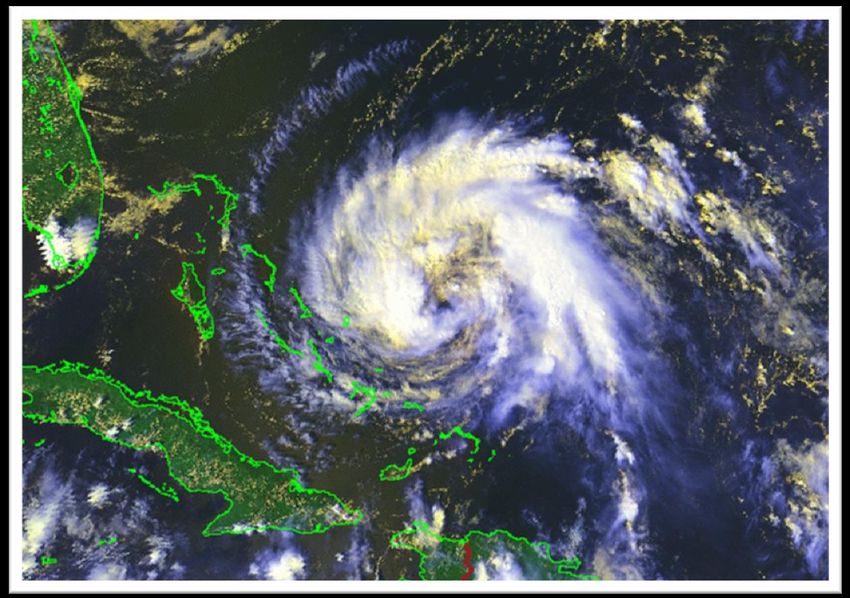
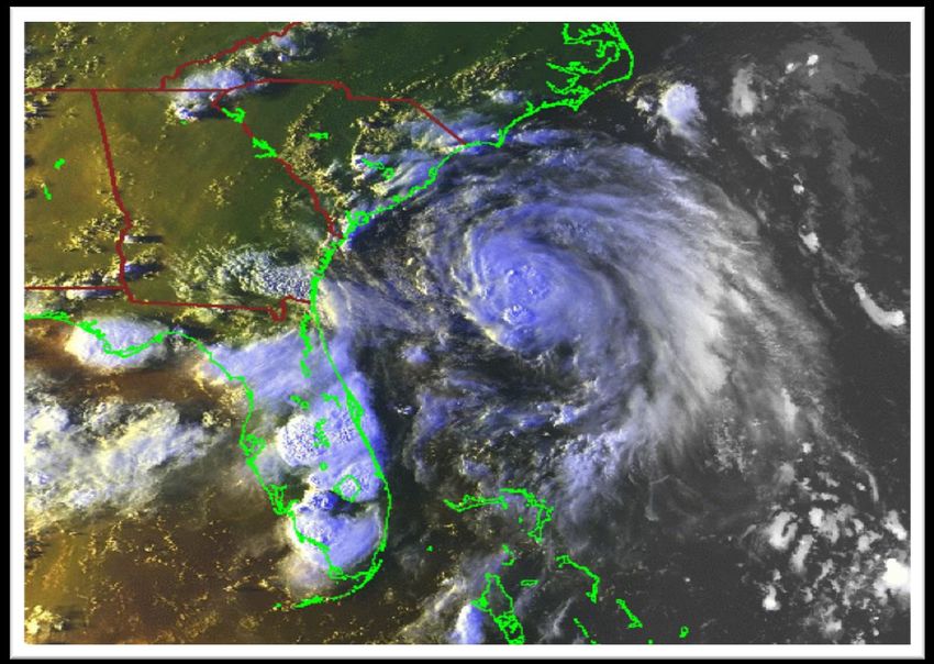
Hugo - Sep 1989
» Images courtesy of NOAA
Hugo 1989 Gracie 1959Important Links
Tropical Cyclone Safety/Preparedness
National Weather Service:
http://weather.gov/om/hurricane/index.shtml
NWS National Hurricane Center:
https://www.weather.gov/wrn/hurricane-preparedness
Federal Emergency Management Agency:
http://www.fema.gov
Department of Homeland Security:
http://www.ready.gov/hurricanes
South Carolina Emergency Management Agency
(includes evacuation zone/route info):
http://www.scemd.org/
Georgia Emergency Management Agency (includes
evacuation zone/route info): http://www.gema.ga.gov/
Tropical Cyclone Forecasts
NHC: https://hurricanes.gov/
NWS Charleston, SC: https://weather.gov/chs/tropicalImportant Links Storm Surge NHC: https://www.nhc.noaa.gov/surge/ Risk Maps: https://www.nhc.noaa.gov/nationalsurge/ Southeast SC/GA Tropical Cyclone History https://www.weather.gov/chs/TChistory Tropical Cyclone Frequently Asked Questions (FAQ) http://www.aoml.noaa.gov/hrd/tcfaq/tcfaqHED.html NOAA Education Resources – Hurricanes http://www.noaa.gov/resource-collections/hurricanes Tropical Cyclone Names https://www.nhc.noaa.gov/aboutnames.shtml Blank Tracking Charts https://www.nhc.noaa.gov/tracking_charts.shtml
https://weather.gov/chs
              @NWSCharlestonSC

https://www.facebook.com/NWSCharlestonSC
You can also read