Upper Barataria Basin Coastal Storm Risk Management and - The Amite River and Tributaries-Comprehensive Study East of the Mississippi River, Louisiana
←
→
Page content transcription
If your browser does not render page correctly, please read the page content below
Upper Barataria Basin Coastal Storm Risk Management
                         and
The Amite River and Tributaries-Comprehensive Study
       East of the Mississippi River, Louisiana
                  Feasibility Studies

                                    GENERAL OVERVIEW MEETING
                                    JANUARY 10, 2019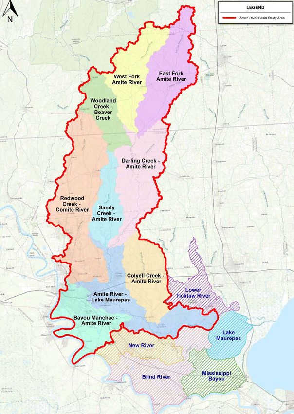
2

                             AGENDA
Welcome & Introductions

Purpose of the General Scoping Meeting

Study Overviews
– Authority
– Coordination
– Schedule
– Planning Process

Upper Barataria Basin Coastal Storm Risk Management

The Amite River and Tributaries-Comprehensive Study
East of the Mississippi River, Louisiana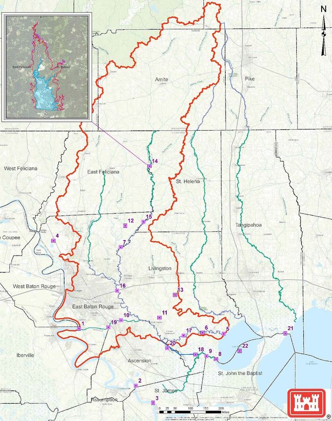
3

         PURPOSE OF THE GENERAL OVERVIEW

Inform the Public
– Provide background on Studies

Solicit input
– Issues and Concerns
– Development of alternatives

  The USACE encourages full public participation to promote open
       communication on the issues surrounding the studies.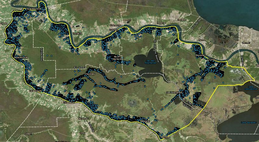
4

                                    STUDY AUTHORITY
Bipartisan Budget Act of 2018
 -   (Public Law 115-123), Division B, Subdivision 1, H. R. 1892—13, TITLE IV, CORPS OF
     ENGINEERS—CIVIL, DEPARTMENT OF THE ARMY, INVESTIGATIONS
 -   Limits scope to the flood risk management

                 Upper Barataria Basin Coastal Storm Risk Management

-House of Representatives Resolution Docket 2554, 105th Congress (6 May 1998):
 -   In the interest of flood control, navigation, wetlands conservation and restoration, wildlife habitat,
     commercial and recreational fishing, salt water intrusion and fresh water and sediment diversion,
     and other purposes in the area

                 The Amite River and Tributaries-Comprehensive Study
                       East of the Mississippi River, Louisiana

-House Document 419, 84th Congress (14 April 1967):
 -   Amite River and Tributaries, Louisiana, Resolved by the Committee on Public Works of the United
     States Senate, that, in accordance with section 3 of the River and Harbor Act of 1902
5

                                     COORDINATION
Non-Federal Sponsors
– Upper Barataria Basin Coastal Storm Risk Management
  • Coastal Protection and Restoration Authority Board

– The Amite River and Tributaries-Comprehensive Study East of the Mississippi River, Louisiana
  • Department of Transportation and Infrastructure

Governmental Stakeholders (such as)
–   Tribes
–   Natural Resource Agencies
–   State of Louisiana and State Agencies
–   Parishes
–   City Officials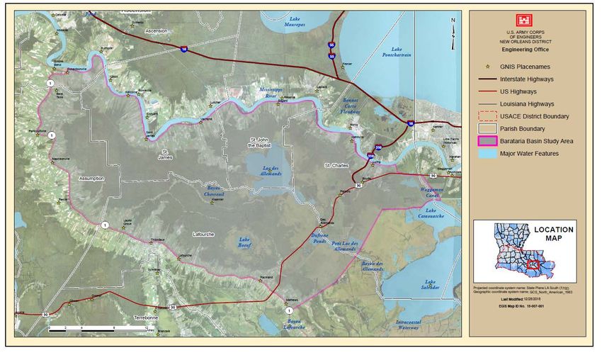
6

                                             SCHEDULE
                    Milestone                       Baseline      Status

Execute FCSA                                      October 2018   Complete
                                                                            We are here
Alternatives Milestone                             2nd Q 2019       -

TSP Milestone                                      3rd Q 2019       -

Release of Draft Feasibility Report for Public
                                                   4th Q 2019       -
Review

Agency Decision Milestone                          1st Q 2020       -

District Submit Final Feasibility Report to MVD    1st Q 2021

Division Engineer’s Transmittal Letter             3rd Q 2021       -

Chief’s Report Milestone                           3rd Q 2021       -
7
PLANNING PROCESS - INITIAL ITERATION
Identify Inventory &
Formulate Evaluate Compare Tentatively
Problems and Forecast
alternatives Alternatives Alternatives Selected Plan
Opportunities conditions
Initial Planning Charette
Define the problem to be addressed,
Conceptual definition of the scale of the project,
Preliminary inventory and forecast of future conditions with available data and information,
Identification of key areas of uncertainty that will impact the study and the project formulation,
Initial identification of the decision criteria that will be used to formulate, compare and select
alternatives.
Initial formulation of alternative plans based on critical thinking and professional expertise.
A draft decision management plan that identifies the level of detail and methods the team will
apply to move to the next decision point.
8

                          INPUT WE NEED FROM YOU

1. Do the problems identified capture what is being experienced in the communities?

2. Are there additional problems related to flooding in the project area that are not captured?

3. With what storm or rainfall event did your community see the most damages?

4. Are there measures or alternative strategies that would address the problems more effectively?

5. Are there additional constraints the planning team should consider?

6. What data, modeling, or reports should be considered as part of the study?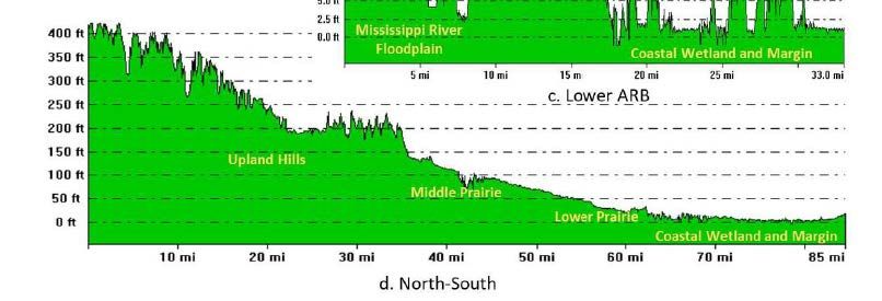
9

UPPER BARATARIA BASIN COASTAL STORM RISK
          MANAGEMENT STUDY
10 STUDY AREA OVERVIEW
11

                                   PROBLEMS

This study area has problems of coastal storm damage from tidal surges, storm
surges, and associated heavy rainfall.

Headwater flooding from rainfall is intensified by tidal events resulting in flood
damages to industrial, commercial, and agricultural facilities as well as residential
structures and critical evacuation routes.

Sea level rise and subsidence are expected to increase the risk of flooding within the
basin.
12
OPPORTUNITIES
Decrease the risk to human life due to flooding events
Reduce flood risk and damages to residential, commercial, historic, cultural, and critical assets and
infrastructure
Limit economic damages and improve economic resiliency of the local economy and communities
Increase the resiliency and reliability of critical infrastructure (industrial and power facilities)
Reduce recovery time from high water events that make evacuation routes and other critical roadways
impassable
Increase community awareness about flooding risks
Conversion of flooding zones to help minimize insurance expenses
Sustain the unique heritage of coastal Louisiana by minimizing impacts from coastal storm events13
OBJECTIVES AND CONSTRAINTS
Objectives Constraints
► Reduce the risk to human life, ► Project features cannot increase flood
health, and safety by reducing flood risk to adjacent areas
impacts to structures, evacuation ► Evacuation capabilities shall not be
routes, and critical infrastructure impeded
► Not to impede transportation of vessels
► Reduce risks to economic impacts to/from the interior basin
due to storm inundation in basin
► Maintain the natural hydrological regime
► Increase community resiliency ► Not to induce development within flood
before, during, and after significant plain - EO 11988
tropical rainfall events ► Limit the impact to endangered species
existing in the area14
NO ACTION ALTERNATIVE
The Future Without Project Condition - is a description of resources and human
environment most likely condition if no study alternative actions are taken.
Increased flood risk
• Continued sea level rise
• Continued subsidence
Increased storm damages
• Frequency
• Intensity
Current Construction Project
• CPRAB 2017 Master Plan (US Highway 90 Alignment)15
STUDY AREA STRUCTURE OVERVIEW
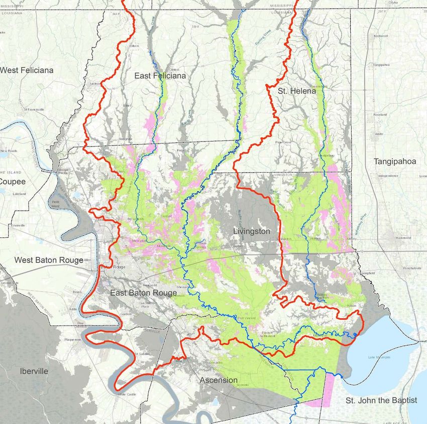
Study Area Boundary
Approximately 28,000 structures reside within the study area, 90% are residential and 10% commercial16 PROJECT OVERVIEW
17

Amite River & Tributaries -Comprehensive Study East of the
                Mississippi River, LA Study
STUDY AREA & 18
HUC SUB-BASINS
• Focus on the study area but
smaller subset (project area)
will include project features
• Also consider impacts in
adjacent basins, where Amite
River backwater flooding has
been a problem19
PROBLEMS
The Amite River and its tributaries can cause flood damages to industrial,
commercial, and residential and nonresidential structures.
The Amite River Basin primarily has flooding from two different sources. The upper
basin flooding is caused from headwater flooding from rainfall events. The Lower
Basin flooding is caused by a combination of drainage from headwaters and
backwater flooding from tides and wind patterns.
Critical infrastructure throughout the region including the I-10 and I-12 transportation
system, government facilities, and schools become more at risk of damage from
rainfall events as climate changes.20
8/2016 FLOOD-FEMA 100-YEAR FLOOD PLAIN
Since 1851, the paths of 51 tropical
events have intersected through the
Amite River and Tributaries project
boundaries.
The 8/2016 floods in LA resulted in
26,909 flood claims paid costing
approximately $2.5 billion.21
OPPORTUNITIES
Protection to life, land, property and infrastructure from flooding
Work with local communities to manage flood risk by leveraging efforts
• Enhance public education and awareness of floodplain management
• Improve flood warnings for preparation and evacuation
• Recommend future modifications to the roadway systems to maintain emergency response vehicles
access during hurricane and tropical storm events
Increase the resiliency of the vitally important I-10/I-12 transportation corridor caused by flood events
Modify channel hydrograph to reduce flood risk
Prevent degradation to fish and wildlife habitat
• Improve water quality
• Increase habitat or slow the trend of habitat quality reduction,
• Encourage land use management
Afford access to recreation (boating, bike trails, camping, swimming, and sightseeing facilities)22
OBJECTIVES AND CONSTRAINTS
Objectives Constraints
► Avoid or minimize negative impacts to
► Reduce flood damages in the Amite River Basin to
• threatened and endangered species and protected species;
business, residents and infrastructure;
• critical habitat, e.g., essential fish habitat (EFH).
• cultural resources;
► Reduce risk to human life from flooding from • recreation users in the basin;
rainfall events; • water quality.
► Reduce interruption to the nation’s transportation ► Portions of the Amite and Comite Rivers are Scenic
corridors; Rivers.
► Reduce risks to critical infrastructure (e.g. medical ► Recognition of local flood management plans.
centers, schools, transportation etc.);
► BBA Authorization limits USACE to flood risk
management.
► Not to induce development within flood plain - EO 11988
Overall Goal: Advance comprehensive risk reduction management
system.23
NO ACTION ALTERNATIVE
Future Without Project Condition- is a description of resources and human environment
most likely condition if no additional actions are taken as a result of this study
Future Development and Change in Floodplain Hydrology
Current Construction Projects
• Comite River Diversion
• East Baton Rouge Flood Control Project
Increased flood risk
• Sea level rise
• Increased marine and river flooding
Increased storm damages
• Frequency
• Intensity
Loss of estuary fisheries and rearing grounds24 PROJECT OVERVIEW
25

AMITE STUDY AREA-INITIAL MEASURES

                  Map ID Measure ID                           Map ID Measure ID
                        1 Diversion Gravity Fed (Manchac)          12 Dry Retention Ponds-Upper Amite
                        1 Diversion Pump Station                   13 Dry Retention Ponds Lower Amite
                          (Manchac)
                        2 Diversion Gravity Fed (Union)            14 Large Scale Dam -Upper Amite (ie Darlingtion)
                        2 Diversion Pump Station (Union)           15 Small Retention Dam -Upper Amite
                        3 Diversion Gravity Fed (Romeville)        16 Upper Amite Bridge Restrictions/ Improvements for I-12
                        3 Diversion Pump Station                   17 Amite River Channel Bank Gapping
                          (Romeville)
                        4 Modifications to Comite Diversion        18 Amite River Diversion Channel Bank Gapping
                        5 Dredging of Outfall @ Amite River        19 Storage Area at Spanish Lake, Ascension/Ibiville Parish
                        6 Dredging of Lower Amite River            20 Hwy 22 Drainage Improvements
                        7 Dredging of Upper Amite River            21 Closures at Tidal Passes
                        8 Dredging of Outfall @ Blind River        22 Dredging of Lake Marpas
                        9 Dredging of Lower Blind River           NA Flood warning/Monitoring systems
                       10 Dredging of Bayou Manchac               NA Dredging of Amite River Tributaries
                       11 Dredging of Colyell Creek               NA Nonstructural Improvements for high freqency events
                       12 Dry Retention Ponds-Upper Amite         NA Ring Levees around Critical Facilities
                       13 Dry Retention Ponds Lower Amite         NA Upper Amite Bridge Restrictions/ Improvements
26
RECAP - INPUT WE NEED FROM YOU
1. Do the problems identified capture what is being experienced in the communities?
2. Are there additional problems related to flooding in the project area that are not captured?
3. With what storm or rainfall event did your community see the most damages?
4. Are there measures or alternative strategies that would address the problems more
effectively?
5. Are there additional constraints the planning team should consider?
6. What data, modeling, or reports should be considered as part of the study?27
QUESTIONS?
Website: https://www.mvn.usace.army.mil/About/Projects/BBA-2018/studies
Written comments:
CEMVN-PM, 7400 Leake Avenue New Orleans, LA 70118.
or
Sarah.C.Bradley@usace.army.mil
FOR FURTHER INFORMATION: Questions concerning the proposed studies should
be addressed to CEMVN PM Phone: (504) 862-1723You can also read