Upper Hyalite Road and Recreation Enhancement Projects
←
→
Page content transcription
If your browser does not render page correctly, please read the page content below
Public Scoping Packet
Upper Hyalite Road and Recreation
Enhancement Projects
Custer Gallatin National Forest, Gallatin County, Montana

April 9, 2018

        For Project Information Contact:
        Wendi Urie
        Bozeman Ranger District
        (406) 522-2535
        https://www.fs.usda.gov/project/?project=53514

                                                            1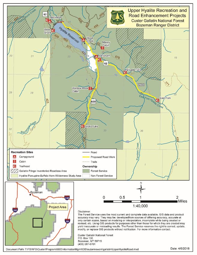
Purpose for Proposed Action
Hyalite Canyon (approximately 10 miles from Bozeman, MT) is one of the most popular recreation
destinations on National Forest System lands within the state of Montana. During the summer this area
receives over 40,000 visitors per month and 20,000 visitors per month during the winter (traffic counters
managed by Friends of Hyalite 2014). The Hyalite area includes nine trailheads, four campgrounds and
three day use areas. The upper Hyalite areas provides access to the Hyalite reservoir and the Porcupine
Buffalo Horn Wilderness Study Area. Currently Hyalite Road #62, South Fork Hyalite Road #620, and
East Fork Hyalite Road #6280 do not safety accommodate the pedestrian and high volume of traffic
utilizing the area. These roads can be difficult to maintain in a satisfactory condition and are narrow with
few turn outs for slow vehicles or emergency situations. The roads are also commonly traveled by foot,
ski or bike by recreationists travelling between recreation sites or trails in this concentrated and
developed recreation opportunities. The purpose of this project is to provide safe, enjoyable, access to
recreation facilities within the Hyalite Canyon recreation area in the context of very high visitation. The
proposed projects will also help reduce negative impacts to water quality by decreasing the level of
sedimentation entering water bodies.
Proposed Action
The proposed action is to perform maintenance and reconstruction on portions of Hyalite Canyon Road
#62, Hyalite Canyon South Road #620, and East Fork Hyalite Road #6280, as well as, implement
numerous recreational enhancements. Recreational enhancements include items such as campground
road improvements, additional parking areas, and paving of popular trailheads. Proposed project
specifics can be found on pages 6-8.

Implementation of phase 1 could occur in summer 2019.

Gallatin National Forest Land and Resource Management Plan (1987)
Direction is provided by the Final Environmental Impact Statement (FEIS) and Land and Resource
Management Plan (Forest Plan) for the Gallatin National Forest (USDA Forest Service 1987 P 206 &
206(a)). The Forest Plan provides direction for all resource management programs, practices, uses, and
protection measures for the Gallatin National Forest. The Gallatin Forest Plan sets goals for public
access and recreational opportunities on the Forest and allocates portions of the land base to help
achieve these goals and objectives (FP II-1). The Gallatin Forest Plan provides overall management
direction in the form of objectives, guidelines and standards. The objectives for recreation resources are
outlined in the Forest Plan on pages II-2 & II-3.

The Gallatin Forest Plan subdivided the forest into 26 management areas (MA's). These areas are
described in detail in Chapter III of the Forest Plan. The Upper Hyalite Road and Recreation
Enhancement projects are located within Forest management areas 1, 5, and 12. Below are summaries
from the Forest Plan, as amended, for these three MAs:
       MA1, these areas include all developed recreation sites such as: campgrounds, picnic
       areas, boat ramps, visitor information sites, air strips, recreation residence tracts, and
       recreation rental cabins (Forest Plan, III-2).
       MA5, these area are travel corridors that receive heavy recreation use (Forest Plan, III-
       20).
       MA12, these areas offer dispersed recreation opportunities (Forest Plan, III-49).
                                                                                                     2
Gallatin National Forest Travel Management Plan (2006)
The Gallatin National Forest Travel Management Plan (2006) identifies and establishes opportunities for
public recreational use and access using the Forest’s road and trail system. For the purposes of
organization and clarity in the Travel Plan, the Gallatin Forest was divided into 39 subunits called
“Travel Planning Areas” (TPAs). Within each TPA you find the route-by-route management direction
for the roads and trails within that area, plus each TPA has their own unique management goals,
objectives, standards, and guidelines. The proposed project location is located within the Hyalite TPA.
The goals, and relevant objectives pertaining to the proposed action, for the Hyalite TPA are:
• Goal 1 Summer Recreation Use. Provide opportunities for both motorized and non-motorized
summer recreation use with emphasis on family-oriented hiking, biking and pleasure driving.
o Achieve the summer recreation opportunities identified in goal 1 through the route-by-
route management decisions made through the Travel Plan.
o Widen the Hyalite Road… to accommodate biking, roller-blading, etc.
• Goal 2 Winter Recreation Use. Provide for a variety of winter recreation opportunities with an
emphasis on family-oriented cross-country skiing and snowshoeing.
o Improve winter passenger vehicle access through the Hyalite Canyon to access winter
recreation opportunities including cross-country skiing, snowshoeing, ice climbing and
fishing.
o Use of sand or salt (NaCl) on the Hyalite Road is to be prohibited.
• Goal 3 Fisheries. Provide habitat for westslope cutthroat trout in Wildhorse Creek. In this Travel
Planning Area, this goal is pursued through application of Forest-wide standards.
• Goal 4 Other Resource Protection. Provide a road and trail system that accommodates traffic
consistent with protecting soil and watershed condition.
o Repair damage to road and trail system and schedule maintenance to attain conditions
that are non-erosive.
2001 Roadless Rule
Approximately 425 ft. of the South Fork Hyalite Road #620 and the Grotto Falls Trailhead is within
Gallatin Fringe Inventoried Roadless Area (IRA). This portion of the Gallatin Fringe IRA is
approximately 353 acres in size with the road and developed trailhead on the far southeast edge of the
IRA as displayed on page 5 (Map 1). It is proposed that in this area the road will be expanded up to an
additional 8 feet creating less than 0.08 acres of new disturbance within the IRA. Portions of this road
are proposed for realignment and reconstruction widening for the purposes of reducing accident
potential associated with combination of factors including: two way traffic volume on a single lane
route with on route pedestrian (foot, bike, ski), narrow roadside parking, and limited site and stopping
distances (7709.56(Chapter 40)). Hazardous condition reports and frequent winter slide offs have been
reported to the District Ranger by recreationists attempting to access the trailhead. This final 450 feet is
also an important last piece to the much larger project which will reduce accident potential, improve
public safety, improve recreation experiences and remedy natural resource issues throughout the
drainage. It would be impractical and cause additional safety and design challenges to end this project at
the IRA boundary.
3This type of road reconstruction within an IRA meets the 2001 Roadless Rule exception 294.12(b)(5):
• Road reconstruction is needed to implement a road safety improvement project on a classified
road determined to be hazardous on the basis of accident experience or accident potential on that
road;
As part of the proposed realignment approximately 18 small diameter (less than 12 inch DBH) trees
would need to be incidentally removed. This type of incidentally timber cutting in the IRA meets the
2001 Roadless Rule exception 294.13(b)(2):
• The cutting, sale, or removal of timber is incidental to the implementation of a management
activity not otherwise prohibited by this subpart;
The 2001 Roadless Rule was the subject of litigation in multiple jurisdictions. Ultimately, the Rule was
judicially upheld and it is in effect, with the exceptions of the States of Idaho and Colorado where
separate rules apply. See Wyoming v. U.S.D.A., 661 F.3d 1209 (10th Cir. 2011) (upholding 2001
Roadless Rule); Kootenai Tribe of Idaho v. Veneman, 313 F.3d 1094 (9th Cir. 2002) (reinstating
Roadless Rule); Jayne v. Sherman, No. 11-35269 (9th Cir. Jan. 7, 2013) (upholding Idaho Roadless
Rule).
The proposed road reconstruction and maintenance activities associated with the Upper Hyalite Road
and Recreation Enhancement projects are consistent with Forest Plan, Travel Plan and other relevant
laws and regulations.
Opportunities to Comment/Contact Information
A notice of proposed action is available on-line at: https://cara.ecosystem-
management.org/Public/CommentInput?project=53514. The scoping packet is also available for review
at the Bozeman Ranger District office located at 3710 Fallon St. Suite C, Bozeman MT 59718.
Additional information regarding this action can be obtained from: Wendi Urie (406) 522-
2535, wurie@fs.fed.us
The proposed project is an activity implementing a land management plan and not authorized under the
HFRA.
How to Comment and Timeframe
Specific written comments on this proposed project will be accepted for 30 calendar days following
publication of this notice on April 9, 2018 and ending on May 8, 2018. This scoping notice will also be
published to the Custer Gallatin National Forests schedule of proposed action (SOPA) on April 6, 2018.
Written comments must be submitted via mail, fax, or in person (Monday through Friday, 8:00 a.m. to
4:30 p.m., excluding holidays) to: Corey Lewellen, District Ranger ATTN: Wendi Urie, 3710 Fallon St.
Suite C, Bozeman MT 59718. Electronic comments including attachments can be submitted
to: https://cara.ecosystem-management.org/Public/CommentInput?project=53514. Formats that will be
accepted for electronically submitted comments are: Word, PDF, and/or Excel.
It is the responsibility of persons providing comments to submit them by the close of the scoping period.
Names and contact information submitted with comments will become part of the public record and may
be released under the Freedom of Information Act.
4Map 1: Upper Hyalite Road and Recreation Enhancement Projects general area.
5Details of the Proposed Action
Hyalite Canyon Road #62 (segment 1): 1.3 mile segment of road leaves the Spillway Bridge at the east
end of Middle Creek Dam to the gate at the Chisholm Trailhead and provides primary access to Hood
Creek & Chisholm Campgrounds, the Maxey Rental Cabin plus other dispersed forest uses. Currently
this roadway averages 2,000 vehicles per day and with population increases is anticipated to receive an
average of 2,600 vehicles per day.
Table 1. Road #62 (segment 1) existing and proposed road standards.
Road Standard Existing Proposed
Road Width 22 ft. 24 ft.
Turnouts Non-existent N/A (2 lane road)
Design Speed 1 20 MPH 25 MPH
Design Grade < 5% < 5%
Surface Aggregate Asphalt
Dust Abatement Calcium Chloride N/A (asphalt)
Alignment adjustments:
- Relocate portions of the roadway, increasing the distance between road and Hood Creek
campsites.
- Relocate portions of the roadway away from lakeshore near Chisholm Day Use Areas to
minimize impacts to recreation use.
- To discourage speed increases along straight stretches of road, curvature of the roadway could be
added.
- Provide parking area space (primary and overflow) for recreational sites along the lakeshore.
Recreational enhancements:
- Construct an overlook parking spot at milepost 10.6 overlooking the Reservoir and Mountains.
- Realign the Hood Creek Campground road approach to better service the mix of overnight
camping, day use lakeshore picnicking, and boat launching.
- Construct a trailhead parking area for the Hood Creek Trail. This would also provide parking for
winter access to the Maxey Rental Cabin.
- Pave the Hood Creek Campground and Day Use loop roads.
- Adjust the Hyalite Youth Camp entrance road to a “T-Style” junction rather the “Y-Style”
junction that currently exists.
- Reconfigure the approach road and parking areas that service the Chisholm Bay Picnic Grounds.
- Pave the Chisholm Campground loop road.
- Pave the Chisholm Trailhead for enhanced summer parking delineation and more efficient
plowing in the winter.
1
Designed speed does not mean there is a speed limit sign in place.
6Hyalite Canyon Road #62 (segment 2): 1.0 mile segment of road leaves the gate at the Chisholm
Trailhead and ends at the Palisades Falls Trailhead and provides primary access to the Palisades Falls
Picnic Area, Palisades Falls Trailhead, the Emerald Lake Trailhead, plus other dispersed forest uses.
Currently this roadway averages 1,800 vehicles per day and with population increases is anticipated to
receive an average of 2,500 vehicles per day.
Table 2. Road #62 (segment 2) existing and proposed road standards.
Road Standard Existing Proposed
Road Width 16 ft. 24 ft.
Turnouts Non-existent N/A (2 lane road)
Design Speed 15 MPH 25 MPH
Design Grade < 5% < 5%
Surface Aggregate Aggregate or Asphalt
Calcium Chloride (aggregate)
Dust Abatement None
N/A (asphalt)
Recreational enhancements:
- Construct several small parking areas alongside the road for dispersed recreational uses.
- Pave the Palisades Falls Trailhead for maximizing parking with better delineation and reduction
of road maintenance.
- Redesign existing Palisades Falls Picnic Area including accessible trails(paved) and picnic
facilities.
- Add aggregate surface to current overflow parking.
Hyalite Canyon South Road #620: Road leaves the Hyalite Canyon Road at the Chisholm Campground
and ends at the Grotto Falls Trailhead. This road provides primary access to Grotto Falls Trailhead and
the Window Rock Rental Cabin as well as dispersed camping and use. Currently this roadway averages
900 vehicles per day and with population increases is anticipated to receive an average of 1,300 vehicles
per day. The last 450 feet of this road and the Grotto Falls trailhead are within the Gallatin Fringe IRA.
Table 3. Road #620 existing and proposed road standards.
Road Standard Existing Proposed
Road Width 14 ft. to 16 ft. 24 ft.
Turnout Spacing Few Inter-visible 2 or 1000ft. (max)
Design Speed 15 MPH 25 MPH
Design Grade < 5% < 5%
Surface Aggregate Aggregate or Asphalt
Calcium Chloride (aggregate)
Dust Abatement None
N/A (asphalt)
2
Inter-visible = visible from turn out to turnout, e.g. you can see from one turnout to the next turn out.
7Recreational enhancements:
- Improve approach onto Road #62 for enhanced site distance (this activity is outside of the
Gallatin Fringe IRA).
- Construct several small parking areas alongside the road for dispersed recreational uses (this
activity is outside of the Gallatin Fringe IRA).
- Add small parking area at the Window Rock Road junction primarily for winter access to the
Window Rock Rental Cabin (this activity is outside of the Gallatin Fringe IRA).
- Pave the Grotto Falls Trailhead for the purpose of maximizing parking delineation and more
efficient plowing in the winter while staying within the existing foot print. (this activity is inside
the Gallatin Fringe IRA)
East Fork Hyalite Road #6280: Road leaves the Hyalite Canyon Road at the Palisades Falls Trailhead
and ends at the East Fork Hyalite Trailhead.
Table 4. Road #6280 existing and proposed road standards.
Road Standard Existing Proposed
Road Width 14 ft. to 16 ft. 18 ft.
Turnout Spacing None Inter-visible or 1000 ft. (max)
Design Speed 15 MPH 25 MPH
Design Grade < 5% < 5%
Surface Aggregate Aggregate
Calcium Chloride (aggregate)
Dust Abatement None
N/A (asphalt)
8You can also read