URBAN AND ECONOMIC ACTIVITIES IN METROPOLITAN STRUCTURING AXES
←
→
Page content transcription
If your browser does not render page correctly, please read the page content below

Recibido: 13-12-2019
                                                                                                                                                                                                           Aceptado: 18-11-2020

                                                                                    URBAN AND
                                                                                    ECONOMIC ACTIVITIES
                                                                                    IN METROPOLITAN
                                                                                    STRUCTURING AXES
                                                                                    THE CONTRIBUTION OF GOOGLE PLACES
                                                                                    GEOLOCATED DATA1
                                                                                    ACTIVIDADES ECONÓMICAS Y URBANAS EN EJES ESTRUCTURANTES METROPOLITANOS
                                                                                    LA APORTACIÓN DE LOS DATOS GEOLOCALIZADOS DE GOOGLE PLACES

                                                                                    LETICIA SERRANO ESTRADA 2
                                                                                    ÁLVARO BERNABEU BAUTISTA 3
                                                                                    PABLO MARTÍ CIRIQUIÁN 4
                                        80

                                                                                    1   This research has received financing from the Conselleria de Innovación, Universidades, Ciencia y Sociedad Digital de la Generalitat
                                                                                        Valenciana and the European Social Fund (ACIF/2020/173).

                                                                                    2   Doctora en Arquitectura y Urbanismo Sostenibles
                           REVISTA URBANO Nº 42 / NOVIEMBRE 2020 - ABRIL 2021
                                                                     PÁG. 80 - 97
                                                  ISSN 0717 - 3997 / 0718 - 3607
ACTIVIDADES ECONÓMICAS Y URBANAS EN EJES ESTRUCTURANTES METROPOLITANOS
              LA APORTACIÓN DE LOS DATOS GEOLOCALIZADOS DE GOOGLE PLACES
  LETICIA SERRANO ESTRADA, ÁLVARO BERNABEU BAUTISTA, PABLO MARTÍ CIRIQUIÁN

                                                                                        Universidad de Alicante, San Vicente del Raspeig, España
                                                                                        Docente e investigadora del Departamento de Edificación y Urbanismo.
                                                                                        https://orcid.org/0000-0002-7466-1974
                                                                                        leticia.serrano@ua.es

                                                                                    3   Máster en Arquitectura
                                                                                        Universidad de Alicante, San Vicente del Raspeig, España
                                                                                        Investigador del Departamento de Edificación y Urbanismo
                                                                                        https://orcid.org/0000-0002-2335-961X
                                                                                        alvaro.bautista@ua.es

                                                                                    4   Doctor en Urbanismo
                                                                                        Universidad de Alicante, San Vicente del Raspeig, España
                                                                                        Catedrático del Departamento de Edificación y Urbanismo
                                                                                        https://orcid.org/0000-0002-6877-784X
                                                                                        pablo.marti@ua.es

                                                                                        DOI: https://doi.org/10.22320/07183607.2020.23.42.07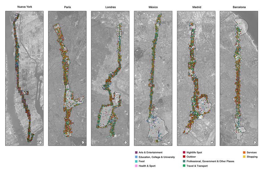
Los ejes viarios metropolitanos son espacios de centralidad urbana y de oportunidad para promover una mejor conectividad
entre las distintas partes del continuo urbano. En este sentido, la caracterización funcional de seis ejes representativos en
Madrid, Barcelona, París, Londres, Nueva York y Ciudad de México permite obtener un diagnóstico actual sobre la densidad
y diversidad de actividades económicas y urbanas, con el fin identificar aspectos clave sobre los que incidir para mejorar su
estructura funcional y social. Para ello, se propone un método que adopta los datos geolocalizados de la red social Google
Places como principal fuente de información. De la investigación se deducen importantes similitudes en el carácter funcional
de los ejes, entre otras, la predominancia de las actividades relacionadas con los servicios y el comercio o la mayor diversidad
de actividades económicas y urbanas en los espacios más centrales. Pero también se identifican diferencias, como son
la especialización de determinadas actividades características en cada eje metropolitano o la diferencial relación entre la
densidad de población y cantidad de actividades, tanto en términos de densidad como en cuantificación lineal. En definitiva, el
método propuesto abre nuevas posibilidades para la planificación estratégica de actividades económicas y urbanas en ámbitos
metropolitanos.

Palabras clave: metrópoli, ejes urbanos, actividades urbanas, redes sociales, Google Places.

                                                                                                                                                                81
Metropolitan road axes are spaces of urban centrality and opportunity to promote a greater connectivity between different parts
of the urban continuum. In this sense, the functional characterization of six representative axes in Madrid, Barcelona, Paris,
London, New York and Mexico City allows obtaining a current analysis of the density and diversity of economic and urban
activities to identify key aspects over which to influence to improve their functional and social structure. For this, a method

                                                                                                                                                                  REVISTA URBANO Nº 42 / NOVIEMBRE 2020 - ABRIL 2021
                                                                                                                                                                                                            PÁG. 80 - 97
                                                                                                                                                                                         ISSN 0717 - 3997 / 0718 - 3607
                                                                                                                                       ACTIVIDADES ECONÓMICAS Y URBANAS EN EJES ESTRUCTURANTES METROPOLITANOS
                                                                                                                                                     LA APORTACIÓN DE LOS DATOS GEOLOCALIZADOS DE GOOGLE PLACES
                                                                                                                                         LETICIA SERRANO ESTRADA, ÁLVARO BERNABEU BAUTISTA, PABLO MARTÍ CIRIQUIÁN
is proposed that adopts the geolocation data from Google Places social network as a main source of information. From the
research, important similarities in the functional character of the axes are deduced, among other the predominance of activities
related to services and shopping or the greater diversity of economic and urban activities in more central spaces. But differences
are also identified, such as the specialization of certain activities characteristic in each metropolitan axis or the differential
relationship between population density and the number of activities both in terms of density and linear quantification. All in all,
the method proposed opens new possibilities for the strategic planning of economic and urban activities in metropolitan areas.

Keywords: metropolis, urban axes, urban activities, social networks, Google Places.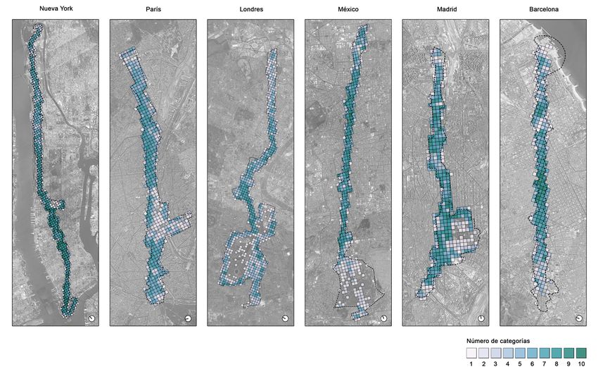
I. INTRODUCTION II. PREVIOUS STUDIES
Traditionally, in Europe and America, the trend of the The metropolitan scale and its structuring axes
big city to expand has been recognized with the term as urban centrality
“metropolitan area of the city”, which covers beyond
the political and administrative limits of the city itself The difference between the city and the metropolis does
(Burgess, 1984, p. 50). Its rapid growth has transformed not exclusively lie in the number of inhabitants or the
the urban landscape and brought with it, new dynamics surface they cover, but also in their functional and social
and spatial and socioeconomic challenges that to date, organization (Park & Burgess, 1984, p.184). While the
continue being great unknowns, especially on there administrative and political boundaries of the city tend
being a significant lack of standardized data (da Cruz, Oh to be rigid, the metropolitan areas are dynamic settings
& Choumar, 2020). insofar as their four dimensions: spatial, social, economic
and environmental (da Cruz et al., 2020).
Indeed, facing the importance of the metropolitan scale
and the acknowledged lack of sources and tools that Despite there not being a consensus in terms of the
allow its study and comparison with other metropolitan spatial boundary of the metropolitan urban sprawl
contexts (Van Susteren, 2005, p.11), the novelty of this (Krätke, 2007), it is often argued that this covers from
research is located. This is an exploratory and comparative the downtown to the areas where daily journeys are
study, fundamentally methodological, whose goal is made, the commuting zone (Burgess, 1984, p.51). That is
the functional characterization of six metropolitan axes to say, the commute affects the spatial boundary of the
starting from the economic and urban activity data so-called “functional urban areas”. This criterion allows
sourced from the Google Places social network. maximizing the international comparability among
metropolitan areas and overcoming the limitation of just
The relevance of analyzing metropolitan axes from a using the administrative boundary (OECD, 2020). In this
functional point of view consists of addressing one of criterion, the structuring axes play a really relevant role as
the key matters in the sustainability of cities: the urban essential elements for mobility as they that spatially link
complexity (Agencia de Ecología Urbana de Barcelona, the periphery-downtown-periphery, facilitating access
AEUB, 2015), that responds to a mixture of uses and from one end of the urban continuum to the other, while
their proximity, and which leads to other issues, like the promoting the feeling of belonging of the residents of
sustainable use of resources and the vitality of urban the periphery, who are also part of the urban vitality of
spaces. the downtown (Park & Burgess, 1984, p. 184).
It starts from the hypothesis that the structuring axes Although Burgess (1984, p. 51) illustrates urban centrality
82
that cross the urban continuum through its central area in the city’s expansion process with a layout of concentric
are aspects of urban centrality, that wander along the circles and where the central area – The Loop – groups the
different fabrics and are physical, social and economic most economically powerful activities, this coexists with
evidence of the evolution and spatial-temporal growth other aspects of centrality, satellite loops, or represented
of the metropolis. And, as such, their analysis implies an by streets, avenues, or crossroads of strategic routes for
REVISTA URBANO Nº 42 / NOVIEMBRE 2020 - ABRIL 2021
PÁG. 80 - 97
ISSN 0717 - 3997 / 0718 - 3607
ACTIVIDADES ECONÓMICAS Y URBANAS EN EJES ESTRUCTURANTES METROPOLITANOS
LA APORTACIÓN DE LOS DATOS GEOLOCALIZADOS DE GOOGLE PLACES
LETICIA SERRANO ESTRADA, ÁLVARO BERNABEU BAUTISTA, PABLO MARTÍ CIRIQUIÁN
opportunity to establish strategies that allow reassessing the mobility and functions of the city (Burgess, 1984,
public policies, improving the management and p.61). Indeed, the central sections of metropolitan
development of these aspects and facing the challenges axes tend to be characterized by their urban centrality
that metropolitization processes involve (da Cruz et al., condition, understood as the concentration, intensity
2020). and variety of urban activities, especially those related to
political decision, innovation and research, diffusion and
In this sense, recent studies have demonstrated the emission, exchange and meeting, ludic or recreational
great potential of social networks to know the amount and of a symbolic nature (Terrazas, 2004, p. 263).
and diversity of the economic offer of the cities (Carpio-
Pinedo & Gutiérrez, 2020) to resolutions that, through Although the urban sustainability seeks the balance
traditional data collection methods, like collecting between the critical mass of population, services and
data onsite, would be boundless. Although there are activity and the connectivity of the fabrics through
studies that specifically address functional analysis continuous corridors of AEUB activity (AEUB, 2015, p.
at a metropolitan scale (Yang & Marmolejo Duarte, 131-133), the metropolitan axes that cross multiple
2019), the functional characterization of their axes from administrative divisions are fields of opportunity.
social networks constitutes a novelty that this research Concretely, because the spatial agglomeration of their
contributes. elements takes place in a longitudinal sense which,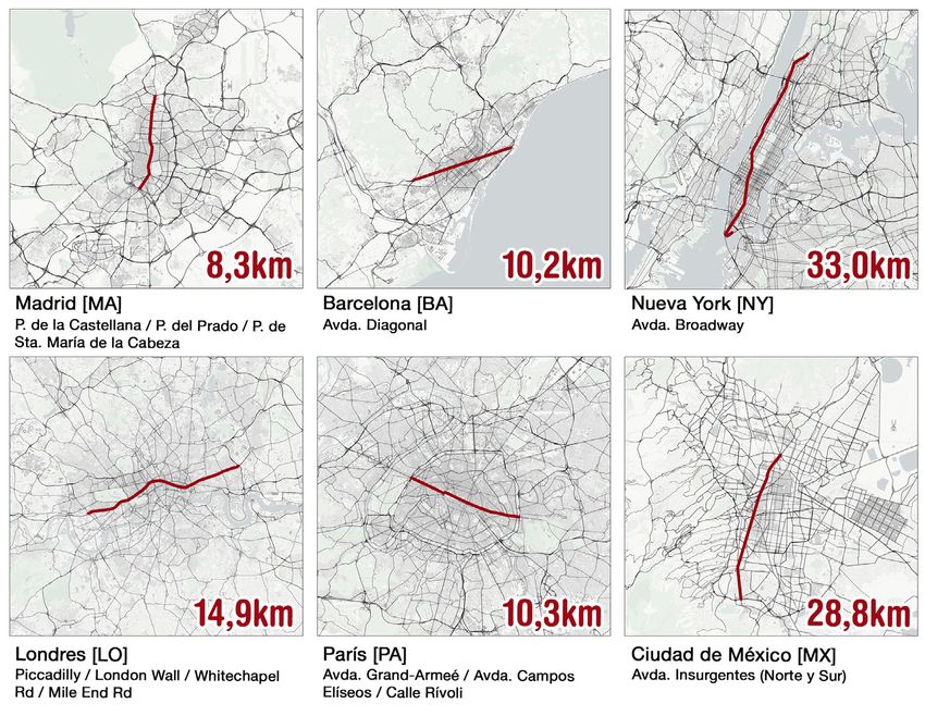
paradoxically, is the least integrated form in itself but          It is for these reasons that, for more than a decade now,
the most integrated towards the exterior and towards               a good part of urban and geographic research has opted
other systems of the region, given that each one of its            to use technology-based sources like social networks and
constituent elements is directly adjoining the exterior            web services that allow obtaining data in an automatic and
space of the form; unlike the circular form, which is more         massive way. The use of these social media has produced
internally integrated, but segregates the peripheral               an important advance in the way of addressing urban and
elements more (Hillier, 2007, p 266).                              territorial research. This is alongside the frequent absence
                                                                   or obsolescence of statistical databases that jeopardize the
The functional analysis of metropolitan axes                       diagnosis and, therefore, a suitable management of the
                                                                   current reality of the territory has derived into a considerable
The analysis of the functional nature of urban areas is of         volume of scientific literature that adopts social networks as
great interest for different reasons. These linear public          a primary source of information (Stock, 2018).
spaces constitute the spatial unit of our experience in the
city (Mehta, 2014), the setting of citizen meeting and the         However, these sources are not free of challenges and
container of public life where social life takes place (Lynch,     limitations (Tasse & Hong, 2014). Among other aspects, the
1984, p. 407).                                                     exhaustive task of previously checking the data to guarantee
                                                                   reliability and representativity of the sample and the
Indeed, the amount and concentration – density – and               restrictions and terms of service established by the platforms
the localization pattern – proximity – of the urban and            themselves, conditioning total or partial access to the
economic uses and activities in these public spaces are            information available within a concrete setting.
determining factors in the level of pedestrian activity
(Hillier, 1996, p. 51; Levy, 1998: p. 61), a matter that is also   In any case, these sources are of interest for this research,
closely related with urban vitality and that, at the same          because it has been shown that it is possible to obtain data
time, is translated into public safety – self-surveillance – (J.   on a metropolitan scale (Folch, Spielman & Manduca, 2018),
Jacobs, 1961). In the same way, the collective image that          and also, in general, these are very extended sources and, thus
is perceived of the environment is, to a good extent, the          allow progressing in the same issue in different geographical
result of the social use and permanence in these linear            contexts. For example, in recent research, the list of urban
spaces, a result of their physical characteristics and of the      activities of Foursquare has been used for urban analysis
layout of the functions in the space (Gehl, 2011, p. 96;           in Asian (Vu, Li & Law , 2020), European (Carpio-Pinedo &
Lynch, 1960, p. 50).                                               Gutíerrez, 2020) and American (Ballatore & De Sabbata, 2020)
                                                                   contexts.
Thus, the analysis of the patterns of urban and economic
uses and activities present in urban axes is a recurrent           Concretely, this research focuses on Google Places, a social
approach among urban researchers to assess the                     network associated to Google Maps that represents “Google’s                                 83
functional nature of the environment and to value                  attempt to add and organize all the information available
whether there is a good amount, mix or specialization or,          about any place in the world” (Barreneche, 2012). Considering
on the contrary, if there are gaps of urban activity.              the goal and scale of the research, the use of this social
                                                                   network implies important advantages over other traditional

                                                                                                                                                                 REVISTA URBANO Nº 42 / NOVIEMBRE 2020 - ABRIL 2021
                                                                                                                                                                                                           PÁG. 80 - 97
                                                                                                                                                                                        ISSN 0717 - 3997 / 0718 - 3607
                                                                                                                                      ACTIVIDADES ECONÓMICAS Y URBANAS EN EJES ESTRUCTURANTES METROPOLITANOS
                                                                                                                                                    LA APORTACIÓN DE LOS DATOS GEOLOCALIZADOS DE GOOGLE PLACES
                                                                                                                                        LETICIA SERRANO ESTRADA, ÁLVARO BERNABEU BAUTISTA, PABLO MARTÍ CIRIQUIÁN
Traditional and current sources for functional                     sources (Martí, Serrano-Estrada y Nolasco-Cirugeda, 2019).
characterization
                                                                   1.   It provides an updated list of the economic and urban
                                                                        activities contained in the building and not just those
Traditionally, the study of the functional nature of urban              that have marketing facing the street.
aspects has been based on an exhaustive collection,                2.   The records are geo-positioned, a characteristic
walking the streets, for the later preparation of maps                  that facilitates the mapping and analysis of the
(Gehl & Svarre, 2013; De Souza & Bustos, 2017; Mehta,                   information.
2014). These methods have disadvantages regarding                  3.   Places registered on the platform are classified
the resources their implementation demands, time and                    by types of activity or tags, a quality which allows
cost, and because only the economic activities that are                 analyzing the type of urban activity in both an
visible from the public space can be recorded. That is to               aggregated and disaggregated way.
say, those activities which are not marketed on public             4.   Google Places, unlike other networks, is used at a
streets, like in the case of offices or businesses located on           global level (Sen, Quercia, Ruiz y Gummadi, 2016)
higher floors of buildings, which likewise contribute to                facilitating both reproducibility of the methods and
the functional nature of the setting, can be unperceived                the comparison between different geographical
in field studies.                                                       aspects.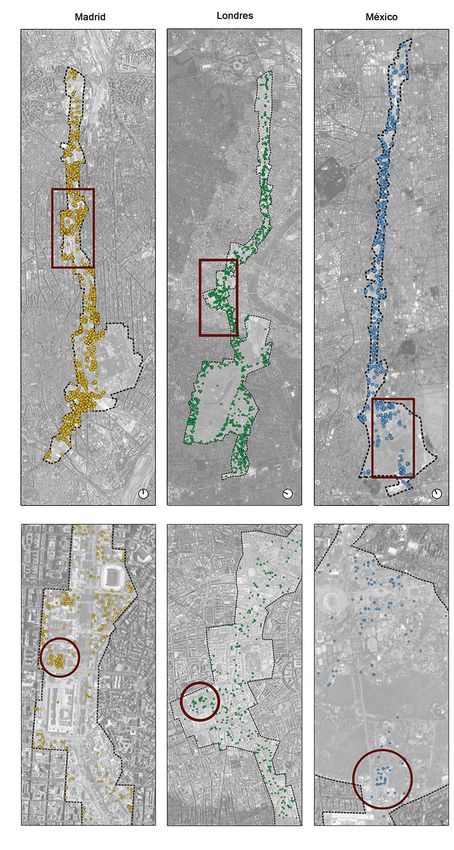
ACTIVIDADES ECONÓMICAS Y URBANAS EN EJES ESTRUCTURANTES METROPOLITANOS
              LA APORTACIÓN DE LOS DATOS GEOLOCALIZADOS DE GOOGLE PLACES
  LETICIA SERRANO ESTRADA, ÁLVARO BERNABEU BAUTISTA, PABLO MARTÍ CIRIQUIÁN

                                                                                    84
                           REVISTA URBANO Nº 42 / NOVIEMBRE 2020 - ABRIL 2021
                                                                     PÁG. 80 - 97
                                                  ISSN 0717 - 3997 / 0718 - 3607

                                                                                         Figure 1.

         Figure 2.
                                                                                         Length of the sections chosen. Source: Authors

         Road intersections that mark the sections. Source: Authors.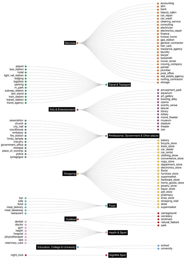
Figure 3.   Relation between metropolitan population and length of the axes.Source: Authors

                                                                            The selection of the sections is based on their importance
III. CASE STUDIES                                                           in the urban structure, connecting periphery-downtown-
                                                                            periphery, and their length is limited by the intersection
For the analysis and comparison of the functional nature
                                                                            with ring-roads, or by the intersection with other first
of metropolitan urban axes in different geographical
                                                                            order metropolitan axes, as is shown in Figure 2.
contexts, six case studies are adopted: four European, the
most representative for the population in Europe, South
                                                                            Once the length of the sections is defined, these are
– Spain, North - UK, and West – France (United Nations,
2018) and two American, including the most populated                        connected to metropolitan population density, checking
metropolitan area of the entire continent, Mexico City,                     that there is a positive high correlation between the two
and the most representative of North America, New York,                     variables (Figure 3).                                                                     85

which leads, alongside London, the financial centers’
ranking at a global level (Morris, Mainelli y Wardle,2015).                 Regarding the spatial marking of the sections in their
                                                                            transversal direction, three disciplinary criteria could be
These are six metropolis that respond to diverse                            considered, adopted by students of the public space and,

                                                                                                                                                                        REVISTA URBANO Nº 42 / NOVIEMBRE 2020 - ABRIL 2021
                                                                                                                                                                                                                  PÁG. 80 - 97
                                                                                                                                                                                               ISSN 0717 - 3997 / 0718 - 3607
                                                                                                                                             ACTIVIDADES ECONÓMICAS Y URBANAS EN EJES ESTRUCTURANTES METROPOLITANOS
                                                                                                                                                           LA APORTACIÓN DE LOS DATOS GEOLOCALIZADOS DE GOOGLE PLACES
                                                                                                                                               LETICIA SERRANO ESTRADA, ÁLVARO BERNABEU BAUTISTA, PABLO MARTÍ CIRIQUIÁN
casuistries regarding their management and                                  concretely, those focused on the analysis of urban activity
socioeconomic context. Thus, in the European context,                       on road links and linear spaces: the façade face (Cullen,
although the four cases represent European hubs for                         1961; Jacobs, 1995; Jacobs, 1961), the social field of vision,
the economy of knowledge (Krätke, 2007), in the case                        which refers to the maximum distance where it is possible
of Madrid and Barcelona, leaders of the Spanish urban                       to see and perceive a person or urban activity – 100 m
system, the management of the metropolitan areas is                         approximately – (Gehl, 2011), and the use in ground floors
still developing, unlike France and the United Kingdom,                     of buildings alongside the urban space (Mehta, 2019). The
examples of best practices and confirmable success                          first two, (Figure 4, right), allow analyzing the urban image
regarding the implementation of metropolitan scale                          and how this affects the human activities that occur in
planning instruments (Hildenbrand, 2017).                                   the space, while, with the third criterion it is possible to
                                                                            understand a relationship between the uses, in uses in the
Spatial boundary of the study area                                          ground floors of the buildings with the socialization of the
                                                                            urban space, (Figure 4, left).
A structuring axis of great relevance is identified
regarding its hierarchy in the metropolitan network of                      Thus, this research conceptually follows the third
each case study and then, a representative section is                       disciplinary criterion, but incorporates the two nuances:
chosen, whose extension is defined in Figure 1.                             first, as has been mentioned above, the Google Places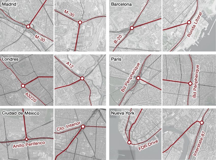
ACTIVIDADES ECONÓMICAS Y URBANAS EN EJES ESTRUCTURANTES METROPOLITANOS
              LA APORTACIÓN DE LOS DATOS GEOLOCALIZADOS DE GOOGLE PLACES
  LETICIA SERRANO ESTRADA, ÁLVARO BERNABEU BAUTISTA, PABLO MARTÍ CIRIQUIÁN

                                                                                    86
                           REVISTA URBANO Nº 42 / NOVIEMBRE 2020 - ABRIL 2021
                                                                     PÁG. 80 - 97
                                                  ISSN 0717 - 3997 / 0718 - 3607

         Figure 5.
         Spatial delimitation of the case studies. Source: Authors.
                                                                                         those exclusively within the route of the axes – right. Source: Authors.
                                                                                         Figure 4. Comparison between the number of urban activities of Google Places included within the spatial limits of the area of study – left – and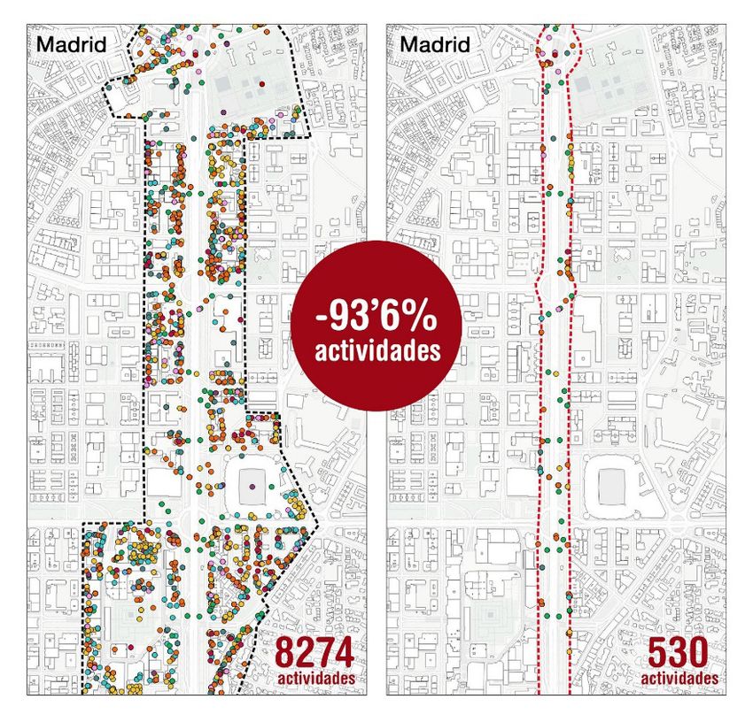
database includes all the economic activities contained       Nightlife spots; Outdoor; Professional, Government and
in the building and not just those located on the             other places; Services; Shopping; Travel and Transport
ground floors; and, second, that each one of these            (Figure 6). Once categorized, the data were displayed on
activities is represented by a point, which can be            a map with the QGIS Geographic Information System,
geopositioned on the façade line or in any other              and after this, two types of analysis were carried out.
location within the lot, or even, of the block, reason
why it is deemed suitable to include the whole block          The first analysis allows getting to know the total
alongside the route of the axes. In the cases where           amount and types of urban and economic activity by
these blocks are occupied by open and public spaces,          axis starting from three metrics: the density of activities,
like parks or urban squares, the edified blocks alongside     which is also contrasted with the population density,
these spaces are likewise considered.                         estimated based on metropolitan density, the average
                                                              number of activities per 100 linear meters of axis,
As for the number of activities recorded that are within      threshold distance at which it is possible to appreciate
the chosen setting, in Figure 4 it is seen that the           the presence of a person (Gehl, 2011) and, the
criterion adopted allows obtaining 93% more data than         representativity of each one of the categories in each
if the façade line had been considered as a spatial limit.    one of the study settings.
In fact, activities are included that, although they do       Although the central fabrics are characterized on having
not directly affect the axis, influence in its functional     higher densities than the periphery ones, a mean is
dimension, on being located near to road intersections        set with the central metropolitan density (OECD, 2020)
that transversally cross the axis. The spatial delimitation   aiming at using a standard criterion for all the cases that
of the six case studies considering the described             allow their comparison. The metrics adopted offer a
criterion, is seen in Figure 5.                               numerical global view about the amount of legal activity
                                                              and sensorial information available at a human scale.

                                                              The second analysis consists in identifying spatial
IV. SOURCES AND METHOD                                        patterns of concentration and diversity of activities
                                                              on the axes. The data are represented by category on
The geolocated data of Google Places were obtained            the map and, in line with the work Sen, Quercia, Ruiz y
through the SMUA– Social Media Urban Analyzer – IT            Gummadi (2016) that also uses the data of Google Places
application (Marti et al., 2019), during May 2018. This is    to study diverse metropolitan settings, an orthogonal
a list of places of interest and economic activities with     mesh is traced aligned to the cardinal axis that cover
specific qualities like: the name of the place, the type      the entire areas. The size of the cell is 200 x 200 meters,
of economic activity or tag (Google Developers, 2019),        the same as the reference mesh that the Ecological
the physical address and the geographic coordinates.          Urbanism Certification (AEUBAEUB, 2015) sets out to                                     87
                                                              measure the different urban sustainability indicators,
Next, the extracted data were checked and validated.          among which is the Urban Complexity. Finally, the
The verification included the manual revision and the         number of different categories present in each cell is
discarding of duplicated data where the information           calculated to characterize the diversity of activities.

                                                                                                                                                        REVISTA URBANO Nº 42 / NOVIEMBRE 2020 - ABRIL 2021
                                                                                                                                                                                                  PÁG. 80 - 97
                                                                                                                                                                               ISSN 0717 - 3997 / 0718 - 3607
                                                                                                                             ACTIVIDADES ECONÓMICAS Y URBANAS EN EJES ESTRUCTURANTES METROPOLITANOS
                                                                                                                                           LA APORTACIÓN DE LOS DATOS GEOLOCALIZADOS DE GOOGLE PLACES
                                                                                                                               LETICIA SERRANO ESTRADA, ÁLVARO BERNABEU BAUTISTA, PABLO MARTÍ CIRIQUIÁN
about the name of the place, the coordinates and the
physical address matched; and the validation focused
on the screening of 128 tags or types of activity
associated to the different places. In addition, it was       V. RESULTS
checked that the types of place listed corresponded
exclusively to economic and urban activities,                 From the data verification of Google Places and the
discarding other types of tags.                               validation of the 128 types of activity or tags, only 87
                                                              types are kept, which refer exclusively to economic and
Once screened, the data were grouped with the goal            urban activities. These are classified in the ten categories
of summarizing the information and aiding its analysis.       of Foursquare, as can be seen in Figure 6.
For this, the taxonomy of places from the Foursquare
social network (Foursquare Inc., 2018) is adopted, as         Regarding the analysis of the data recorded and in
unlike other social networks, it has a structure that         respect to the characteristics of the axes and the
is well defined in ten main categories for the rating         population of each one of the metropolitan areas,
of places of interest and establishments (Keßler y            a series of correlations are established through the
McKenzie, 2019): Arts and Entertainment; Education,           combination of the diverse variables (Table 1 and
Schools and Universities; Food; Health and Sport;             Figure 5).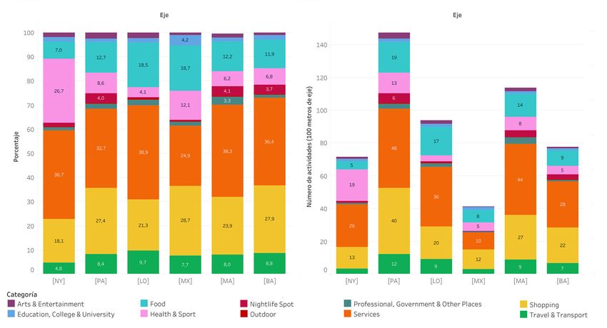
ACTIVIDADES ECONÓMICAS Y URBANAS EN EJES ESTRUCTURANTES METROPOLITANOS
              LA APORTACIÓN DE LOS DATOS GEOLOCALIZADOS DE GOOGLE PLACES
  LETICIA SERRANO ESTRADA, ÁLVARO BERNABEU BAUTISTA, PABLO MARTÍ CIRIQUIÁN

                                                                                          88
                           REVISTA URBANO Nº 42 / NOVIEMBRE 2020 - ABRIL 2021
                                                                     PÁG. 80 - 97
                                                  ISSN 0717 - 3997 / 0718 - 3607

         Figure 6.
         Grouping of Google Places’ tags in the Foursquare categories. Source: Authors.
Activity density (act/km2)
metropolitan central area
Population density of the
Metropolitan population
Activities by each linear
Length of the axis (km)
Activities recorded in
(2018) (OECD, 2020)
Axis surface (km2)
Metropolitan Area
Google Places
(inhab/km2)
(UN, 2018)
(2018)
100 m
Mexico City [MX] 28.8 14.1 21,581,000 5237 11,915 845 41
New York [NY] 33.0 8.6 18,819,000 1445 23,600 2744 72
London [LO] 14.9 11.6 9,046,000 3486 14,023 1209 94
Paris [PA] 10.3 6.7 10,901,000 4999 15,164 2263 147
Madrid [MA] 8.3 7.2 6,497,000 3828 9,413 1307 114
Barcelona [BA] 10.2 5.9 5,494,000 6661 7,916 1342 78
Table 1. Data recorded by metropolitan axis. Source: Authors.
The first finding of interest is that, with the six sections meters increases linearly, Figure 8, contrary to the
being very active, according to what the density terms of density, from which it can be deduced that
of activities recorded indicates, three groups are the population density affects the proliferation of
recognizable: the NY and PA axes, with the highest activities along the route of the axis, but not so much
concentration of activity; followed by LO, MA and BA, its population density in areas alongside it. And the 89
with medium densities; and MX with a significantly lower relationship between population density and activities,
density of activities. As for the presence of activities by Figure 9, corroborates that, for similar activity densities,
each 100m, the PA axis leads the list along with MA, next, like BA, LO or MA, the number of activities every 100
the LO, BA and NY axes have similar amounts and, finally, meters is very uneven, which is why the density in a
REVISTA URBANO Nº 42 / NOVIEMBRE 2020 - ABRIL 2021
PÁG. 80 - 97
ISSN 0717 - 3997 / 0718 - 3607
ACTIVIDADES ECONÓMICAS Y URBANAS EN EJES ESTRUCTURANTES METROPOLITANOS
LA APORTACIÓN DE LOS DATOS GEOLOCALIZADOS DE GOOGLE PLACES
LETICIA SERRANO ESTRADA, ÁLVARO BERNABEU BAUTISTA, PABLO MARTÍ CIRIQUIÁN
MX is the axis with the lowest presence of activities. longitudinal sense is not related with the density of the
In this sense, the European cases stand out over the blocks adjoining the route of the axis. In any case, NY
American ones, with a higher amount of activities every stands out as the most singular case, due to its lower
100 m. This would lead to other considerations and population density and higher activities density which,
morphological type debates, which are outside the goal nevertheless, are not reflected in the linear quantification.
of the research.
Regarding the type of activities, the Services category
Relating the population density and that of activities standards out in the six areas of study (Table 2 and
in the scatter graph of Figure 7, a negative correlation Figure 10) as it exceeds 30% of the total activities in
between these two parameters can be seen: the lower five of the six cases. Likewise, the Shopping category,
the population density is, the density of activities in even more important than the Services category in MX,
the axis increases. Thus, those cities with the highest is the second most represented one in MA, BA, LO and
population densities, like MX, have the lowest activities PA, with more than 20% of the total activity. In NY, the
density, while the case with the lowest population category Health and Sport is the second most relevant
density, NY, has the highest number of activities. activity, barely represented in the rest. The Food category
However, the relationship between population is significant in MX and LO, exceeding 18% of the total
density and the number of activities by each 100 activities, unlike the case of NY with 7%.90
REVISTA URBANO Nº 42 / NOVIEMBRE 2020 - ABRIL 2021
PÁG. 80 - 97
ISSN 0717 - 3997 / 0718 - 3607
ACTIVIDADES ECONÓMICAS Y URBANAS EN EJES ESTRUCTURANTES METROPOLITANOS
LA APORTACIÓN DE LOS DATOS GEOLOCALIZADOS DE GOOGLE PLACES
LETICIA SERRANO ESTRADA, ÁLVARO BERNABEU BAUTISTA, PABLO MARTÍ CIRIQUIÁN
Figure 7. Relationship between activities density and population density. Source: Authors.
Figure 8. Relationship between activities every 100 linear meters and population density.Source: Authors.
Figure 9. Relationship between activities every 100 linear meters and activities density. Source: Authors.Madrid Barcelona Londres París Nueva York México
[MA] [BA] [LO] [PA] [NY] [MX]
Artes y
Entretenimiento
(Arts & 173 1,8% 86 1,1% 320 2,3% 377 2,5% 427 1,8% 133 1,1%
Entertainment)
Educación,
Colegios y
Universidades
(Education, 148 1,6% 138 1,7% 252 1,8% 214 1,4% 459 1,9% 502 4,2%
College &
University)
Establecimientos
de Restauración
(Food) 1152 12,2% 942 11,9% 2588 18,5% 1920 12,7% 1643 7,0% 2227 18,7%
Salud y Deporte
(Health & Sport) 673 7,1% 542 6,8% 579 4,1% 1307 8,6% 6303 26,7% 1436 12,1%
Ocio nocturno
(Nightlife Spot) 342 3,6% 290 3,7% 83 0,6% 599 4,0% 340 1,4% 50 0,4%
Aire Libre y
Recreación
26 0,3% 48 0,6% 85 0,6% 47 0,3% 95 0,4% 44 0,4%
(Outdoors &
Recreation)
Profesional, 91
Gobierno y
Otros Lugares
315 3,3% 84 1,1% 312 2,2% 314 2,1% 264 1,1% 210 1,8%
(Professional,
Government &
REVISTA URBANO Nº 42 / NOVIEMBRE 2020 - ABRIL 2021
PÁG. 80 - 97
ISSN 0717 - 3997 / 0718 - 3607
ACTIVIDADES ECONÓMICAS Y URBANAS EN EJES ESTRUCTURANTES METROPOLITANOS
LA APORTACIÓN DE LOS DATOS GEOLOCALIZADOS DE GOOGLE PLACES
LETICIA SERRANO ESTRADA, ÁLVARO BERNABEU BAUTISTA, PABLO MARTÍ CIRIQUIÁN
Other places)
Servicios
3608 38,3% 2881 36,4% 5456 38,9% 4961 32,7% 8667 36,7% 2968 24,9%
(Services)
Comercio
2248 23,9% 2207 27,9% 2990 21,3% 4158 27,4% 4267 18,1% 3422 28,7%
(Shopping)
Turismo y
Transporte
(Travel & 728 7,7% 698 8,8% 1358 9,7% 1267 8,4% 1135 4,8% 923 7,7%
Transport)
TOTAL 9413 100% 7916 100% 14023 100% 15164 100% 23600 100% 11915 100%
Table 2. Data of Google Place recorded by area and category. Source: Authors.ACTIVIDADES ECONÓMICAS Y URBANAS EN EJES ESTRUCTURANTES METROPOLITANOS
LA APORTACIÓN DE LOS DATOS GEOLOCALIZADOS DE GOOGLE PLACES
LETICIA SERRANO ESTRADA, ÁLVARO BERNABEU BAUTISTA, PABLO MARTÍ CIRIQUIÁN
92
REVISTA URBANO Nº 42 / NOVIEMBRE 2020 - ABRIL 2021
PÁG. 80 - 97
ISSN 0717 - 3997 / 0718 - 3607
Figure 11. Distribution of urban activities. Source: Authors
Figure 10. Frequency of the types of activity (left) and number of activities per 100 linear meters (right). Source: Authors.Figure 12. Number of different categories by 200 x 200 m cell surface area. Source: Authors.
Regarding the category of Travel and Transport, present The PA and LO axes are the least diverse, with cells that
in similar amounts in all the axes, it represents spaces gather between 4 and 6 activities on average. It also
linked to public transportation and shows the great stands out on how the diversity drops considerably
connectivity and the structuring role of the analyzed around the large parks. 93
areas, Figure 10, left.
Finally, areas with a certain specialization have been
Regarding the spatial distribution of the activities (Figure detected, whose main activity rarely accepts another
11) with the exception of some very limited areas, type of use, for example, the case of the financial areas in
REVISTA URBANO Nº 42 / NOVIEMBRE 2020 - ABRIL 2021
PÁG. 80 - 97
ISSN 0717 - 3997 / 0718 - 3607
ACTIVIDADES ECONÓMICAS Y URBANAS EN EJES ESTRUCTURANTES METROPOLITANOS
LA APORTACIÓN DE LOS DATOS GEOLOCALIZADOS DE GOOGLE PLACES
LETICIA SERRANO ESTRADA, ÁLVARO BERNABEU BAUTISTA, PABLO MARTÍ CIRIQUIÁN
where activity gaps are seen, in general the axes have LO or the university campuses of MX and BA (Figure 13).
similar patterns, with a higher concentration of urban
activity in central zones and a tendency towards the
spreading of activity at the extremes. This is logically
by reasons of centrality, since these axes connect VI. DISCUSSION
central and compact areas with more peripheral and
spread out areas and, therefore, with higher and lower Among the most important challenges that the
concentration of activity, respectively. NY is an exception metropolitan areas present is guaranteeing the
since it maintains a homogenous concentration of urban sustainability of the built environment in all its
activity in practically the entire axis, with the extreme dimensions through the design of governance strategies
south, Lower Manhattan standing out, where the city’s that respond, both to a timely and current diagnosis,
financial center is located. and to the needs of the citizens.
This aforementioned trend is confirmed with the analysis Attending the urban complexity and the distribution
of activity diversity (Figure 12). The central areas have a of uses in the territory, starting from evaluating the
higher diversity than the extremes, with the exception density and diversity of economic and urban activities
of NY which has a high diversity along the whole axis. at a metropolitan scale, directly affects the public spaceACTIVIDADES ECONÓMICAS Y URBANAS EN EJES ESTRUCTURANTES METROPOLITANOS
LA APORTACIÓN DE LOS DATOS GEOLOCALIZADOS DE GOOGLE PLACES
LETICIA SERRANO ESTRADA, ÁLVARO BERNABEU BAUTISTA, PABLO MARTÍ CIRIQUIÁN
94
REVISTA URBANO Nº 42 / NOVIEMBRE 2020 - ABRIL 2021
PÁG. 80 - 97
ISSN 0717 - 3997 / 0718 - 3607
Figure 13. Visualization of data by categories. Source: Authors.social use at a human scale (AEUBAEUB, 2015, p.133). universities, hospitals or shopping centers are located,
However, obtaining updated data for this type of like the university campus of UNAM in Mexico or La Paz
detailed diagnoses implies an important challenge Hospital in Madrid.
(da Cruz et al., 2020). This study faces this difficulty,
using data from the Google Places social network
and proposes a general grouping of urban activities
in ten categories. Nevertheless, it could all consider a VII. CONCLUSIONS
second level of grouping by tag or type of activity by
cell, allowing a greater granularity for specialization The metropolitan axes, especially those that cross
diagnoses and/or lack of establishments and the urban center, represent spaces of opportunity as
services of a given sector. Likewise, research that urban activity corridors that connect and structure the
addresses matters related with the perception and diverse sections that flow along their route. For the
urban vitality would be benefitted from this type of analysis and comparison of these metropolitan axes,
detailed analysis. For example, it has been shown just as for any study that intends on addressing the
that, although there is a good mixture of activity in metropolitan scale, it is essential to not sidestep the
the case of the MX axes, it is necessary to reevaluate lack or non-existence of databases, standardized and
the amount and proximity of these, considering the updated on the same recording date. In this sense, one
population density to guarantee a correct distribution of the more relevant contributions of this research is
and balance that promotes the self-containment and the methodological approach that uses the geolocated
functional self-sufficiency of the area (AEUBAEUB, data of Google Places to functionally characterize six
2015, p.229). Moreover, it is this axis out of the six metropolitan axes: New York, Paris, London, Mexico
analyzed, where commercial and food activities City, Madrid and Barcelona. The comparison between
dominate, activities that provide a good amount of these great structuring axes has allowed identifying
information and sensorial stimuli to the passersby similarities and differences regarding the density,
through their “soft facades” (Gehl & Svarre, 2013, diversity and patterns of localization, concentration
p.77), unlike the NY axis, where the Health and Sport and specialization of the economic activity.
category is greater than the number of commercial
establishments. Another consideration that emerges As for the density of activities, a certain concentration
from and is related to the use of the public space is seen in the central sections and, in general, a
would be crime prevention through urban design spread in the peripheral areas. In respect to the
– CPTED – Crime Prevention Through Environmental diversity of activities, there is an important mix
Design – and self-surveillance by guaranteeing the and complementarity of uses, even in areas whose
passing through and recurrent stay of people in the functional imaginary is traditionally tied to very
urban space (Newman, 1972). For example, in the MX specific uses, like shopping on Rue Rivoli in Paris or 95
axis, the supply of activities related to nightlife and entertainment on Brooklyn Avenue in New York. The
arts and entertainment are negligible in comparison European cases stand out in this aspect, benefitting
with the case of PA. from a greater mix of uses.
REVISTA URBANO Nº 42 / NOVIEMBRE 2020 - ABRIL 2021
PÁG. 80 - 97
ISSN 0717 - 3997 / 0718 - 3607
ACTIVIDADES ECONÓMICAS Y URBANAS EN EJES ESTRUCTURANTES METROPOLITANOS
LA APORTACIÓN DE LOS DATOS GEOLOCALIZADOS DE GOOGLE PLACES
LETICIA SERRANO ESTRADA, ÁLVARO BERNABEU BAUTISTA, PABLO MARTÍ CIRIQUIÁN
Other matters related to land uses and its In general, the results ratify the hypothesis that the
morphology with the urban activities they hold are chosen sections are urban centrality areas since they
also shown. In this sense, a large scale urban green include, to a greater or lesser extent, administrative
space is identified in all the cases alongside the axis, activities, of innovation and research, of diffusion and
around which the diversity of activities tends to drop. emission, of exchange and meeting, ludic and symbolic
Likewise, although predictable, since in the European (Terrazas, 2004, p. 253). Furthermore, the method has
and American city, the form and role are interrelated allowed confirming very particular matters, like, for
matters (Hillier, 1996, 0.43), the results show a clear example, that in the MX axis, with lower density of
relationship between the predominant type of activities compared to the population density, there is
activities of an area and its morphology, being able to a greater number of innovation and research activities,
confirm that certain categories of economic activities activities dense in knowledge (AEUBAEUB, 2015, p.
have spread in areas whose physical structure and 229), while the PA axis, which heads the list in density
makeup allow it. For example, in central urban of activities for every 100 linear meters, it does not
fabrics a greater presence of activities related with include records in this category.
restaurants or shops close to the ground floor and
professional services on higher floors is identified, All of the above demonstrate the potential of the
while in the periphery areas, large facilities like Google Places social network as a source of globalinformation for urban studies at a metropolitan scale, and Jacobs, J. (1961). The death and life of great American cities. New York:
Vintage Books.
the pertinence of running diagnostics about the offer
and distribution of economic and urban activities that Keßler, C. y McKenzie, G. D. (2019). Consistency Across Geosocial
allow designing strategies seeking a better planning and Media Platforms. En Proceedings of the 15th International Conference on
management of the metropolis. Location-Based Services (pp. 2013–2018). Viena, Austria. DOI: https://doi.
org/10.34726/lbs2019.57
Krätke, S. (2007). Metropolisation of the European economic territory
as a consequence of increasing specialisation of urban agglomerations
VIII. BIBLIOGRAPHICAL REFERENCES in the knowledge economy. European Planning Studies, 15(1), 1–27. DOI:
https://doi.org/10.1080/09654310601016424
Agencia de Ecología Urbana de Barcelona. AEUB (2015). Certificación del
Levy, R. M. (1998). The visualisation of the street. Computer modelling
Urbanismo Ecológico. Recuperado de http://www.bcnecologia.net/
and urban design. En N. R. Fyfe (Ed.), Images of the street: planning, identity,
and control in public space (pp. 58-74). Nueva York: Routledge.
Ballatore, A. y De Sabbata, S. (2020). Los Angeles as a digital place: the
geographies of user-generated content. Transactions in Gis, 24(4), 880-
Lynch, K. (1960). The image of the city. Massachusetts: MIT Press.
902. DOI: https://doi.org/10.1111/tgis.12600
Lynch, K. (1984). Good city form. Cambridge: MIT Press.
Barreneche, C. (2012). Una página Web para cada lugar en el mundo:
Google, codificación y comodificación del espacio. Actas del II Congreso
Martí, P., Serrano-Estrada, L. y Nolasco-Cirugeda, A. (2019). Social Media
Internacional sobre Imagen, Cultura y Tecnología (pp. 231–241). Madrid,
data: Challenges, opportunities and limitations in urban studies.
España.
Computers, Environment and Urban Systems, 74, 161–174. DOI: https://doi.
Burgess, E. W. (1984). The growth of the city: an introduction to a research org/10.1016/j.compenvurbsys.2018.11.001
project. En Park, R. E., Burgess, E. W. y McKenzie, R. D. (Eds.),The City.
Suggestions for investigation of human behavior in the urban environment Mehta, V. (2014). The Street: A Quintessential Social Public Space. New York:
(pp. 47–62). Chicago: The University of Chicago Press. Rouledge.
Carpio-Pinedo, J. y Gutiérrez, J. (2020). Consumption and symbolic Mehta, V. (2019). Streets and social life in cities: a taxonomy of sociability.
capital in the metropolitan space: Integrating ‘old’ retail data sources Urban Design International, 24(1), 16-37. DOI: https://doi.org/10.1057/
with social big data. Cities, 106, 102859. DOI: https://doi.org/10.1016/j. s41289-018-0069-9
cities.2020.102859
Morris, H., Mainelli, M. y Wardle, M. (2015). The Global Financial Centres
Da Cruz, N. F., Oh, D. Y. y Choumar, N. B. (2020). The metropolitan scale. Index 27.
Cities, 100, 102644. DOI: https://doi.org/10.1016/j.cities.2020.102644
Newman, O. (1972). Defensible space. People and design in the violent city.
De Souza, M. V. y Bustos, A. (2017). El comercio informal de calle en las London: Architectural Press.
comunas Santiago y Concepción. Revista Urbano, 20(35), 58–73. DOI:
https://doi.org/10.22320/07183607.2017.20.35.05 OECD. (2020). Stat- Metropolitan areas. Recuperado de https://stats.oecd.
org/
Folch, D. C., Spielman, S. E. y Manduca, R. (2018). Fast Food Data: Where
User-Generated Content Works and Where It Does Not. Geographical Park, R. E. y Burgess, E. W. (1984). The City. Suggestions for investigation
96 Analysis, 50(2), 125–140. DOI: https://doi.org/10.1111/gean.12149 of human behavior in the urban environment. Personality and Individual
Differences (Vol. 2). Chicago: The University of Chicago Press.
Foursquare INC. (2018). Foursquare Venue Categories. Recuperado de
https://developer.foursquare.com/docs/resources/categories Sen, R., Quercia, D., Ruiz, C. V. y Gummadi, K. P. (2016). Scalable urban
data collection from the web. En Proceedings of the 10th International
Gehl, J. (2011). Life between buildings: using public space. Washington: Conference on Web and Social Media, ICWSM 2016 (pp. 683–686). Colonia,
REVISTA URBANO Nº 42 / NOVIEMBRE 2020 - ABRIL 2021
PÁG. 80 - 97
ISSN 0717 - 3997 / 0718 - 3607
ACTIVIDADES ECONÓMICAS Y URBANAS EN EJES ESTRUCTURANTES METROPOLITANOS
LA APORTACIÓN DE LOS DATOS GEOLOCALIZADOS DE GOOGLE PLACES
LETICIA SERRANO ESTRADA, ÁLVARO BERNABEU BAUTISTA, PABLO MARTÍ CIRIQUIÁN
Island Press. Alemania.
Gehl, J. y Svarre, B. (2013). How to study public life. Washington: Island Press. Stock, K. (2018). Mining location from social media: A systematic review.
Computers, Environment and Urban Systems, 71(Mayo), 209–240. DOI:
Google Developers (2019). Place Types. Recuperado de https:// https://doi.org/10.1016/j.compenvurbsys.2018.05.007
developers.google.com/places/supported_types
Tasse, D. y Hong, J. I. (2014). Using social media data to understand
Cullen, G. (1961). The Concise Townscape. Architectural Press. cities. En NSC workshops on big data and urban informatics. Chicago.
Recuperado de https://www.dantasse.com/docs/using_social_media_
Hildenbrand, A. (2017). El abandono de la cuestión metropolitana en data_to_understand_cities_bduic2014.pdf
España. La necesidad de dar un nuevo impulso para su replanteamiento.
Revista Iberoamericana de Urbanismo, (13), 25–46. Recuperado de http:// Terrazas, O. (2004). La centralidad metropolitana en la ciudad de México.
hdl.handle.net/2117/108615 En A. Rodriguez Kuri y S. Tamayo Flores-Alatorre (Eds.), Los últimos cien
años. Los próximos cien... (pp. 236–265). México: Universidad Autónoma
Hillier, B. (1996). Cities as movement economies. Urban Design Metropolitana.
International, 1(1), 41–60. DOI: http://dx.doi.org/10.1057/udi.1996.5
United Nations. Department of Economic and Social Affairs. Population
Hillier, B. (2007). Space is the machine. A configurational theory of Division (2018). The World’s Cities in 2018 - Data Booklet (ST/ESA/ SER.A/417).
architecture. London: Space Syntax.
Van Susteren, A. (2005). Metropolitan world atlas. Rotterdam: 010
Jacobs, A. B. (1995). Great Streets. Cambridge: MIT Press. Publishers.Vu, H. Q., Li, G. y Law, R. (2020). Cross-Country Analysis of Tourist Activities
Based on Venue-Referenced Social Media Data. Journal of Travel Research, 59(1),
90–106. DOI: https://doi.org/10.1177/0047287518820194
Yang, L. y Marmolejo Duarte, C. (2019). Identifying tourist-functional relations
of urban places through Foursquare from Barcelona. GeoJournal. DOI: https://
doi.org/10.1007/s10708-019-10055-9
97
REVISTA URBANO Nº 42 / NOVIEMBRE 2020 - ABRIL 2021
PÁG. 80 - 97
ISSN 0717 - 3997 / 0718 - 3607
ACTIVIDADES ECONÓMICAS Y URBANAS EN EJES ESTRUCTURANTES METROPOLITANOS
LA APORTACIÓN DE LOS DATOS GEOLOCALIZADOS DE GOOGLE PLACES
LETICIA SERRANO ESTRADA, ÁLVARO BERNABEU BAUTISTA, PABLO MARTÍ CIRIQUIÁNYou can also read