UTS Campus Kuring-gai - Heritage Assessment & Conservation Strategy Re-issued September 2007
←
→
Page content transcription
If your browser does not render page correctly, please read the page content below
July 2004

Heritage Assessment &
Conservation Strategy
Re-issued September 2007

CRI Australia Pty Ltd

UTS Campus
Kuring-gai
GRAHAM BROOKS AND ASSOCIATES PTY LTD
HERITAGE CONSULTANTS
UTS Campus, Kuring-gai
Heritage Assessment and Conservation Strategy                September 2007

Table of Contents

1.0      Introduction                                                 3
1.1      Background and Purpose of the Study
1.2      Current Heritage Management Framework
1.3      Photographic and Documentary Sources
1.4      Acknowledgements
1.5      Research Methodology
1.6      Authorship
1.7      Site Location
1.8      Bibliography

2.0      Historical Summary                                           10
2.1      19th Century Pastoral Uses and Land Ownership
2.2      Commonwealth Ownership, 1915
2.3      William Balmain Teachers’ College, Balmain, 1946
2.4      Site Selection, 1955-1967
2.5      Project Formulation, 1967
2.6      Architectural and Landscape Design
2.7      Stage One, 1971
2.8      Stage Two, 1972
2.9      Stage Three, 1976
2.10     Stage Four, 1980
2.11     Stage Five, 1988
2.12     Subsequent Works, 1990
2.13     UTS Initial Upgrading, 1993-1995
2.14     Major Reorganisation, 1996
2.15     Operational Review by UTS, 2003

3.0      Description                                                  64
3.1      The Context of the Site
3.2      The Building Complex
3.3      The Landscaped Context and Playing Fields
3.4      Condition and Integrity
3.5      Comparative Assessment

4.0      Assessment of Heritage Significance                          77
4.1      Assessment of Significance
4.2      Statement of Heritage Significance
4.3      Grading of Significant Components
4.4      Curtilage

5.0      Conservation Strategies                                      85
5.1      Management of Significance
5.2`     UTS Operational Requirements
5.3      Conservation and Development of the Overall Site
5.4      Conservation and Adaptive Re-use of the Buildings

Graham Brooks and Associates Pty Ltd                                 Page 2
UTS Campus, Kuring-gai
Heritage Assessment and Conservation Strategy                                    September 2007

1.0
Introduction
1.1      Background and Purpose of the Study
This Heritage Analysis and Conservation Strategy for the UTS Kuring-gai Campus at Eton
Road, Lindfield, has been prepared for submission of a concept plan and State Significant
Site Application to the Minister for Planning.

UTS has engaged CRI Australia Pty Ltd (CRI) and a team of specialist planning and
environmental advisors, to prepare a concept plan and State Significant Site Amendment for
the possible redevelopment of the overall site to be lodged with the Department of Planning.
Simultaneously with this study and Development Scheme preparation, UTS is undertaking a
review of the operations of the Kuring-gai College and its sustainability within the UTS
educational framework. It is anticipated that the planning and operational studies will provide
UTS with sufficient detail to enable a decision to be made regarding the future of the site.

A Community Reference Group (CRG), comprising local community and business nominees
and UTS representatives was formed in late 2003, following discussions between CRI and
Kuring-gai Council. This CRG has been reformed in the light of the current proposal for future
use of the site.

This Heritage Assessment and Conservation Report has been prepared in the context of the
previous environmental, heritage, engineering and planning research as well as Guidelines
issued by the NSW Heritage Office and the requirements of the EP&A Act and the NSW
Heritage Act.

The findings and recommendations of this Report have informed the preparation of the
proposed Development Scheme and its associated rezoning proposal. It has also informed
the deliberations by UTS regarding the future of the College and the overall site. The
Heritage Assessment and Conservation Report will be submitted in conjunction with the
Concept Plan / State Significant Site Amendments.

1.2      Current Heritage Management Framework
The UTS Kuring-gai Site is not currently listed on any statutory heritage registers at Local or
State level.

The Site was entered as an “Indicative Place”, on the Register of the National Estate (RNE).
With the introduction of new Commonwealth Heritage Legislation on 1 January 2004, the
Australian Heritage Commission ceased to exist and was replaced by the Australian Heritage
Council. The operative Commonwealth legislation is now the Environment Protection and
Biodiversity Conservation Act 1999 (EPBC Act). This Act controls heritage issues in relation
to two classes of places, National Heritage Places and Commonwealth Heritage Places. It
generates no statutory heritage management obligations on non-Commonwealth owned
properties. The UTS Site is not Commonwealth owned and is unlikely to be included in the
register of National Heritage Places. The Register of the National Estate remains operative
as a list of places with recognised heritage values, but it has no statutory power to manage
those values.

Listing as an “Indicative Place” was the first stage of recognition of the place by the then
Australian Heritage Commission. It is apparent from the listing information that the Register
entry was prepared when the complex was “eight years old”, and had received the RAIA
(NSW) Sulman Award. This indicates that the entry was probably made in the late 1970s, not
long after the complex received the Sulman Award.

Graham Brooks and Associates Pty Ltd                                                     Page 3
UTS Campus, Kuring-gai
Heritage Assessment and Conservation Strategy                                             September 2007

In the years since the nomination of the place to the RNE, the Australian Heritage
Commission did not develop or consolidate a full registration of the place to the RNE.

The Nominator’s Statement of Significance, drawn from the RNE web site states:

         The College is an outstanding example both of the harmonious development of a rugged
         bushland site and of the design of a visually strong and dramatic structure which successfully
         captures the essence of the function for which it was designed. All of these qualities have been
         formally recognised by the College's recent award of the Sulman medal for architecture. The
         maximum preservation of natural features of the site has resulted in a bushland setting used
         extensively for environmental education within an urban residential environment.

Inclusion on the Register of the National Estate, particularly as an Indicative Place, imposed
no statutory heritage management or planning obligations on non-Commonwealth property
owners or managers. It was a recognition of the cultural heritage qualities of the place.

The UTS Kuring-gai Campus has not been entered on the NSW State Heritage Register
(SHR). The web site for the NSW Chapter of the Royal Australian Institute of Architects (28
November 2003) carried a notice indicating that the Campus was to be nominated to the
NSW State Heritage Register by the RAIA. As of March 2004, the NSW Heritage Office had
issued no formal notification of any intent to nominate the Campus to the SHR.

If the site were to be included on the NSW State Heritage Register, the NSW Heritage
Council would become the effective consent authority for heritage management of the place.
Kuring-gai Council would then need take account of any advice from the Heritage Council in
determining any application for rezoning or development.

In November 2003, Kuring-gai Council voted to prepare a Heritage Assessment of the UTS
Kuring-gai Campus Site, and if merited to prepare and exhibit a Draft LEP for listing as an
Item of the Environmental Heritage on the Kuring-gai Planning Scheme Ordinance. Until any
such assessment and LEP listing process is completed, there are no formal or statutory
heritage management obligations on the site. Kuring-gai Council would normally refer any
request for rezoning of the site to the Heritage Office for comment, as part of the processes
under the EP&A Act. It is likely that Council would also take potential heritage issues into
account as part of its consideration of any rezoning application. In February 2004, Council
appointed an independent heritage consultant consortium to prepare a Heritage Assessment
of the Campus and advise Council of its potential for listing. The Heritage Assessment
prepared for Council and this Report should be read in conjunction with each other.

The UTS Kuring-gai Campus has been entered on the RAIA List of 20th Century Buildings of
Significance, in recognition of its architectural qualities. The RAIA first recognised the
Campus buildings (Stage One) in 1971, with a Merit Award. In 1978, the College (completed
to Stage Three) received a Sulman Award, the highest recognition at the time available from
the RAIA NSW Chapter. In 1973, it was awarded an Honourable Mention in the Structures
Section of the Concrete Institute Awards in Japan. Inclusion within the RAIA List of 20th
Century Building of Significance, or the award of any prize by the Institute, imposes no
statutory heritage management or planning obligations on the site. It is a recognition of the
architectural qualities of the complex.

The UTS Kuring-gai Campus, is not currently Classified by the National Trust of Australia
(NSW). Classification by the National Trust imposes no statutory heritage management or
planning obligations on the site. It primarily recognises the architectural and heritage qualities
of the complex.

This Heritage Assessment and Conservation Strategy has relied on the published
descriptions of the work of Bruce Mackenzie and Associates, and on recent discussions with
Bruce Mackenzie to evaluate the landscape setting of the campus rather than to undertake an
external evaluation. It has not examined the potential for the site to be of interest to the NSW
Department of Conservation and Environment, in terms of their obligations to protect and
manage Aboriginal Cultural Heritage material or values. A separate research study,
commissioned by CRI, is being undertaken in this regard.

Graham Brooks and Associates Pty Ltd                                                              Page 4
UTS Campus, Kuring-gai
Heritage Assessment and Conservation Strategy                                   September 2007

1.3      Photographic and Documentary Sources
Photographic and Documentary material used for the preparation of this Heritage Assessment
were sourced from the NSW Chapter of the Royal Australian Institute of Architects, with the
kind assistance of Ms Anne Hyam. Other sources included the City of Sydney Library, State
Library, NSW Lands Title Office, NSW Lands Department , the Plans Room of the
Government Architect’s Office, and the NSW Department of Commerce. The archives and
maintenance records of UTS and UTS Kuring-gai College also provided valuable material.

Contemporary photographs were taken by Graham Brooks, in late 2003 and early 2004,
specifically for the preparation of this Heritage Assessment and Conservation Strategy.

1.4      Acknowledgements
The authors would like to thank a number of people who contributed to the research and
preparation of this report.

Both David Don Turner and Bruce Mackenzie gave generously of their time, their memories
and written material to explain their personal aims and objectives for the project. Each was
interviewed both in their offices and on site and have participated in subsequent planning and
design workshops. They were able to add a personal dimension to the contemporary
documentary reports that form the backbone of this Heritage Assessment.

Ken Woolley provided recollections of his time as a key member of the architectural
movement known as the Sydney School in the 1960s.

Ron Hirst and Glen Rabbit from UTS Facilities Management and Building Maintenance, for
their commentary on detailed works to the complex over the last 10 years.

Anne Hyam RAIA provided much of the background information regarding contemporary
commentaries held by the Institute and copies of recent correspondence with both David
Turner and Bruce Mackenzie.

Jon Pizey and Marina Chung of DEM Pty Ltd, Architects, Planners and Landscape Architects
for their involvement in the exploration of the UTS site, its nature and the exploration of
opportunities for further development.

Geoff Baxter and Angela Petousis from CRI Australia Pty Ltd, for their role as UTS advisers
and managers for the rezoning application project.

1.5      Research Methodology
The formulation of this Heritage Assessment and Conservation Strategy was facilitated by a
unique opportunity to engage with the original design architect and landscape consultant in
addition to those facilities managers who have been responsible for the management of the
complex over the last decade. There was also a wealth of contemporary published and
unpublished commentaries available that enabled the project to be viewed through the prism
of its own time. The project was the design and development of a major educational complex
that developed over at least five major stages of construction and then evolved through many
smaller works and maintenance programmes.

The approach taken developed an understanding of the complex as a whole, supported as
relevant by details of particular works programmes or project outcomes. Accordingly there
has been a concentration on the contemporary published works to establish that
understanding. Detailed documentary research was undertaken as necessary in Public
Works, Kuring-gai Council and UTS archives, primarily to fill out detailed questions as they
arose.

Graham Brooks and Associates Pty Ltd                                                    Page 5

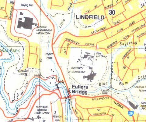
UTS Campus, Kuring-gai
Heritage Assessment and Conservation Strategy                                    September 2007

The greatest opportunity, however, came from the personal involvement of David Don Turner,
the original Design Architect, who stayed with the project right through its major development
phases, and Bruce Mackenzie, the Landscape Architect whose drive and vision so
successfully complemented the original design concept of a compact building mass that
touched the rugged bushland of this spectacular site so lightly.

Uniquely, both David Turner and Bruce Mackenzie accepted an offer from UTS and CRI to
contribute to the development of the conservation strategies and the identification of
development opportunities for the main building complex and the overall site. The
conservation strategies contained in this document have been drawn from their valuable
contributions.

This Heritage Assessment also responds to the Director General’s Requirements issued for
the site.

1.6      Terminology
Throughout this report the terminology “Kuring-gai” has been adopted. It had been a
deliberate policy of the CAE to use “Kuring-gai” as a simpler form of spelling. This policy has
been continued by UTS.

1.7      Authorship
Graham Brooks and Dr Christina Amiet of Graham Brooks and Associates Pty Ltd, Heritage
Consultants prepared this Heritage Assessment and Conservation Strategy.

1.8      Site Location
The UTS Kuring-gai Campus is located off Eton Road, Lindfield, in northern Sydney.
Millwood Avenue, Lady Game Drive and Winchester Avenue bound the general area.

Site Location

Graham Brooks and Associates Pty Ltd                                                     Page 6
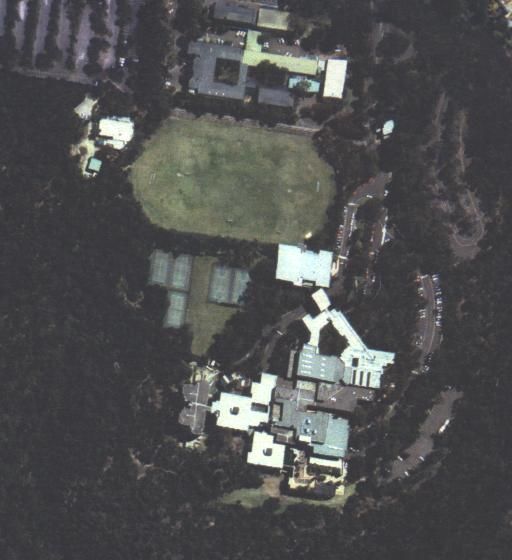
UTS Campus, Kuring-gai
Heritage Assessment and Conservation Strategy   September 2007

Aerial Photo of the Site Context

Graham Brooks and Associates Pty Ltd                    Page 7
UTS Campus, Kuring-gai
Heritage Assessment and Conservation Strategy                                      September 2007

1.9      Bibliography
Unless otherwise noted, the information and quotations in the Historical Summary section
have been based on “To Enlighten Them Our Task” (1996), pp 125-143.

In addition to material obtained from Land and Property Information, other consulted sources
include:

Apperly, R., Irving, R., and Reynolds, P., Identifying Australian Architecture: Styles and Terms
from 1788 to the Present, Angus and Robertson, Sydney, 1989.
Architecture Bulletin, January 2004.

Architecture in Australia, June, 1971 – 1979 (selected journals)

Architecture Today, July 1971.

Building ideas, June 1976.

CRI, University of Technology Sydney, Kuring-gai Campus Concept Masterplan Options
Study (Phase 1), July 2003.

Doyle, C., A Respected Colonist: William Henry of Lane Cove, William and Jane Henry
Association, Sydney, 1984.

Godden Mackay Logan and Keyes Young, Kuring-gai Heritage and Neighbourhood Character
Study, prepared for Kuring-gai Municipal Council, June 2000.

Hartley, L., “Millwood Farm” Lane Cove, owned by William Henry” for Assessment of
Historical Archaeology, University of Sydney, 1984.

Jack, R., The work of the NSW Government Architect’s Branch, 1958-1973, thesis (M.Arch)
submitted to University of New South Wales, 1980.

Johnson, D.L. The Architecture of Walter Burley Griffin, Macmillan, Melbourne, 1977.

Jahn, Graham, Sydney Architecture, Watermark, Balmain, 1997.

Kuring-gai College of Advanced Education, Inside KCAE, Lindfield, 1977.

Kuring-gai Historical Society, Focus on Kuring-gai: The story of Kuring-gai’s growth and
development, Lindfield, 1996.

Lane Cove National Park Minutes of Meeting of Park Trustees, 1938-1961.

Lenehan, M.F., Footprints on the Sands of Time: Lane Cove 1788-1988, Lane Cove Historical
Society, Sydney, 1987.

McLoughlin, L. and Wyatt, M., The Upper Lane Cove: History, Heritage, Bibliography,
Macquarie University Graduate School of the Environment, 1993.

Metcalf, A., Architecture in Transition: The Sulman Award 1932-1996, Sydney 1997.

Roseville Community Association, William Henry’s 40 Acres and the People who Lived there:
then and Now, Sydney, 2000.

Stateworks: Department of Public Works Staff Association Journal, November 1978.

Taylor, J., (second edition) Australian Architecture since 1960, Canberra, 1990.

Graham Brooks and Associates Pty Ltd                                                       Page 8
UTS Campus, Kuring-gai
Heritage Assessment and Conservation Strategy                                      September 2007

Taylor, J., John Andrews, Architecture a Performing Art, Oxford University Press, Oxford,
1982.

Turnbull, J., and Navaretti, P., (eds) The Griffins in Australia and India: the complete works of
Walter Burley Griffin and Marion Mahoney Griffin, Melbourne, 1998.

Votes and Proceedings of the New South Wales Legislative Assembly, 1859-1860.

Walker, M, Kabos, A and Weirick, J., Building for Nature: Walter Burley Griffin and
Castlecrag, Walter Burley Griffin Society, 1994.

Wolff, G.C., The Sydney School, Unpublished B.Arch thesis for the Faculty of Architecture,
University of New South Wales, 1984.

Graham Brooks and Associates Pty Ltd                                                       Page 9
UTS Campus, Kuring-gai
Heritage Assessment and Conservation Strategy                                       September 2007

2.0
Historical Summary
2.1      19th Century Pastoral Uses and Land Ownership
2.1.1 Early Days
The site originally formed part of a one thousand acre parcel of land promised to settler
William Henry by Governor William Bligh. Originally a marine with the English Navy, Henry
was convicted for grand larceny and sentenced to seven years transportation in 1800, arriving
in Sydney on the Earl Cornwallis in June 1801. In 1806, Governor Bligh offered Henry the
position of principal overseer of public works, together with 1,000 acres of land situated on the
north side of the Lane Cove River. Henry immediately took possession of the land; the 1806
Muster listed him as having a ticket-of-leave, and as self-employed. In addition to his work
with the government, Henry joined ships sailing to Tasmania, Port Dalrymple and Otaheite.1

Following the arrest of Governor Bligh in 1808, Henry was stripped of his position, but
remained loyal to his patron. In retaliation for his refusal to support the new government, his
house was searched, and Henry was manacled and temporarily transported to Newcastle. By
1810, Governor Lachlan Macquarie had released Henry, whereupon he purchased a sloop
and traded in grain and spirits on the Hawkesbury River.

In 1813, he received a grant of forty acres from Macquarie, adjacent to his 1,000 acre
property, and by December 1828 was able to lease a further 1,000 acres adjoining the land
promised by Bligh. This was possible due to a Government Notice of 1826, stipulating that
any person having a freehold could lease the land adjoining their properties on paying a rental
of two shillings and sixpence per hundred acres to the Crown. This also entailed an
understanding that the lessor had the option to purchase the land. Henry built a bark hut on
the flat on the south bank of Blue Gum Creek, near its junction with the Lane Cove River
                                                                                          2
(present-day Fullers Park), and used this as the base of his farm, known as Millwood. Henry
also cleared other parts of the land, selling timber and running cattle with the assistance of his
son. Within a short space of time Henry sold his 40 acre grant and moved his family and
business wholly onto the leased 1,000 acres and Bligh’s 1,000 acres, which he claimed in
1832 had cost him “sixteen years in labour in clearing and cutting a road.”

In addition to land clearing, cultivation and rudimentary construction of Millwood Farm, he
claimed responsibility for the construction of three roads or tracks in the local area. Henry is
believed to have made Fullers Road in about 1814 as an access way to the river, and by the
time of an 1831 survey, the roadway was a well-established route. A second road likely to
have been built by William Henry and situated in close proximity to the UTS campus is
Grosvenor Road, extending to the present Lady Game Drive. This was believed to be one of
the earliest routes to the river, and support for Henry’s claim is sustained in that the road runs
close to the northern boundary of William Henry’s ridge grant. However, the 1831 survey
labelled the route as Cadby’s road, with early survey maps indicating that the line of the road
was also along the south-western boundary of Cadby’s land.

The alignment of Shirley Road may have been the third route made by William Henry c.1814,
extending from his 40 acre grant on the Lane Cove Road down to the river. It is suggested
that the route followed the present-day Shirley Road, across to Abingdon Road, and then
                                                               3
followed Little Blue Gum Creek to join with Blue Gum Creek, essentially skirting the future
campus buildings but tracking through the subject site generally. The route was not recorded

1
  C. Doyle, A Respected Colonist: William Henry of Lane Cove, p.16.
2
  L. Hartley, “Millwood Farm” Lane Cove, owned by William Henry, for Assessment of
Historical Archaeology, University of Sydney, 1984, p.14
3
  NSW Legislative Assembly, 1859-1860, Vol.4, p.1195.

Graham Brooks and Associates Pty Ltd                                                      Page 10
UTS Campus, Kuring-gai Heritage Assessment and Conservation Strategy September 2007 by early surveyors, although there is some physical and documentary evidence of an old road in the vicinity.4 From the early 1830s, Henry’s entitlement to Millwood Farm land was challenged. In 1831, Robert Ball applied for one hundred acres as a grant in the area (portion 292). This request encroached on part of the one thousand acres Henry was leasing from the Crown, and included the site of Henry’s hut, allegedly built by 1829,5 together with convict quarters. Upon objection he was informed that the lease had expired and he should have vacated that land by 1829. In addition, testimony in 1831 by surveyor J.G. Larmer indicated that that the land had not been cultivated, but merely cleared. Resolute, Henry remained on site for some time. Map showing land claimed by William Henry (Source: Roseville Community Association, William Henry’s 40 Acres) The UTS Campus site is located towards the south west corner of the West Roseville segment 4 L. McLoughlin and M. Wyatt, The Upper Lane Cove, pp.19-20. 5 L. Hartley, “Millwood Farm” Lane Cove, owned by William Henry, for Assessment of Historical Archaeology, University of Sydney, 1984, p.14. Graham Brooks and Associates Pty Ltd Page 11
UTS Campus, Kuring-gai
Heritage Assessment and Conservation Strategy                                             September 2007

A description of the farmstead as a whole, including the lands promised by Bligh, indicated
that:

         Defendant [Henry] has a comfortable cottage and orchard; defendant’s son has a cottage on
         the same ground; defendant resides about half a mile from him; there are huts near his son’s
         residence; there are fruit trees near the son’s orchard; defendant’s orchard attached to his
         house might be two acres; the land between defendant’s house and his son’s has been
         cultivated in part; defendant’s son has what appears to be an orchard with full grown trees; saw
         Henry’s orchard about twelve years ago; the land is fenced in part; knew defendant resided
         there upwards of twenty years ago; never heard he was turned out of possession of this land
                                                 6
         from that period up to the present time.

While based at Millwood Farm, he appealed to officials to confirm his right to the land, and
that Macquarie had told surveyor Meehan to document both land promised by Bligh and the
leased 1,000 acres. Henry’s claim to ownership through long residence and improvements
was rejected, and the 100 acre grant was formally made to Robert Ball on 5 April, 1836.7
Eventually Henry was turned off the property in September 1851, and he went to live with his
eldest daughter Maria, who also resided in the area. Following his eviction, parcels of
Millwood Farm was made available to other interested parties.

A petition by William Henry to the Legislative Assembly of New South Wales in 1860 was
followed by a hearing at the Court of Claims. Eventually, it was concluded that:

         Your committee consider that the fidelity of Henry to the Government of the day, in a time of
         successful rebellion justly entitled him to the grant of land, which he alleges was promised to
         him; and looking at all the facts of the case, they are of the opinion that such promise was
         made as alleged. They, therefore, think he was unlawfully dispossessed, and is entitled to
         liberal compensation from the present Governor for the injury he has sustained.8

William Henry never received the compensation owed to him, however, and he died in 1862,
despite the evidence supporting his claim to the area.

2.1.2 Secondary Settlement Phase: 1850s
The site of the future UTS Kuring-gai Campus, on part of the land once occupied by William
Henry, was contained within six parcels of land later resumed by the Commonwealth:

    •    Portion 292 (granted in 1836) was sold by Robert Ball to James Atkinson in 1837.9 In
         turn, Emily Atkinson transferred the land in October 1866 to Thomas and Jane
         Fuller,10 who lived in the area. Jane was one of William Henry’s daughters, who
         married Thomas Fuller in 1829. Having purchased a nearby grant to establish a pear
         orchard (located to the south of Ball’s land), they then acquired Ball’s property to
         expand their prosperous business. Beginning in 1869, they gradually sold the majority
         of the land to local resident, relative and fellow orchardist Thomas Jenkins.

    •    Portions 440 and 441 were granted to Thomas Jenkins, described in 1855 as
         “boatman”, comprising approximately sixty-nine acres, two roods.11 Thomas was the
         nephew of early settler James Jenkins, who received several grants in the Dee Why/
         Pittwater area, as well as 50 acres adjoining the 40 acre grant given to William Henry.
         In 1849 Thomas Jenkins married Maria Elizabeth Maher, a granddaughter of William
         Henry, with their homestead “Waterview” established close to the site of the former
         Millwood farmhouse.

6
   Government Surveyor Benn,
7
   BK 42 p.33, LPI.
8
   Summation by Henry Parkes, NSW Legislative Assembly 1859-1860, Vol.4.
9
  BK114 Reg.149.
10
   Bk100 #622.
11
   Volume 145, Folio 243, LPI

Graham Brooks and Associates Pty Ltd                                                             Page 12
UTS Campus, Kuring-gai
Heritage Assessment and Conservation Strategy September 2007
• Portion 96 was granted to Henry Wheeler, late Captain in the 48th Regiment of Foot,
in January 1855. An Indenture of Release from Henry and Matilda Wheeler to Lewis
Gordon was documented in May 1855.12 Gordon, however, held numerous parcels of
land throughout Sydney and the outlying areas, and did not attempt to develop the
site. On 1st November 1870, Gordon mortgaged the land to William Henry Dyson,
with further changes made on 28th November.13 Five years, later, on 10th December
1875, a Release and Reconveyance was documented.14 Thomas Jenkins then
purchased the 20 acre property for one hundred and seventy-five pounds on 14th
March 1879.15
• Portion 439 was formally acquired by Alexander Couper and Hugh Henry Ould in
September 1876.16 This land changed hands several times in the years before
Commonwealth resumption, but there is no evidence that any of the owners became
residents.
• Portion 137 was granted to Henry Wood on 13 January 1842, with a quit rent of
sixteen shillings and eightpence.17
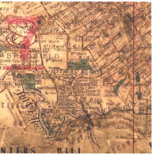
Map showing the original land portions and grantees, overlaid by street alignments, roadways, the
extent of the Teachers’ College campus and other land resumed by the Commonwealth (portions 96,
137, 292, 439, 440 and 441 (Source: Doyle, A Respected Colonist.)
12
Book 39 No.573, LPI.
13
Book 122 No 156; Book 122 No 222.
14
Book 166 No 191
15
Book 189 No.73A
16
Volume 267, Folio 43, LPI.
17
V. 3725 F.229.
Graham Brooks and Associates Pty Ltd Page 13UTS Campus, Kuring-gai
Heritage Assessment and Conservation Strategy September 2007
2.1.3 Jenkins Estate, 1869
Thomas Jenkins acquired a significant part of William Henry’s original holdings, including the
forty acres granted to Henry by Macquarie and portion 441, granted to him in 1869. The
adjoining Portion 440 was granted to him on 29 August 1872. Their farm, radiating outwards
from the present day administration area of the Lane Cove National Park, was the
cornerstone of a noted market enterprise, with the produce of their orchards and livestock
sent to Sydney via the family riverboat Nellie on the Lane Cove River to the fish, fruit and farm
produce markets in York Street.
In 1879, the land separating his holdings - portion 96 granted to Henry Wheeler - was
purchased by Jenkins and added to his growing estate. In 1882 he purchased from Jane and
Thomas Fuller part of the 100 acres of portion 292 originally granted to Robert Ball. Following
his death in 1890, the lands were held by his widow Maria, who also acquired another grant,
18
of one acre, one rood and twenty-one perches, in March 1895. Previously this land had
been designated as “Wharf Reserve,” and ran along the western boundary of Henry
Wheeler’s original grant. The land was mortgaged in 1899 to Albert Murray Smidmore, and
again in 1908 to Henry Massey Makinson and William Patrick Plunkett.
In August of 1913, Maria was still in possession of 173 acres that extended from the western
extent of Henry’s 40-acre grant to Blue Gum Creek. Across the majority of portion 441, and
extending into portion 440, was proposed a residential development19 first put up for auction
in February 1912 and based around Shirley Road. While most were situated in portion 441,
lots 18, 19 and 20 encroached onto portion 440. This area of some 66 acres was sold, in 23
lots, between 1912 and the early 1920s, and resulted in an extension of Shirley Road, and the
formation of Glen Road.
In May 1914 a transfer of mortgagee occurred, from William Plunkett to the Perpetual Trustee
Company Ltd, with the mortgage itself discharged shortly thereafter and a subsequent
mortgage taken out in July 1914, from Maria Jenkins to Wilhemina Stewart Hogan of
Strathfield. Throughout the 1913-1914 period, the transferral of numerous lots was recorded.
Chatswood fruit merchant John Jenkins, the seventh child of Thomas and Maria, became the
owner of Lots 17-20, stretching across part of portions 440 and 441 and containing ten acres,
20
three roods and twenty-nine and three-quarter perches. Title to the land was issued subject
to a covenant whereby no building exceeding the value of three hundred pounds was to be
constructed on the land. In 1918, Maria Jenkins was recorded as living on a part of this land,
on “Glen Road off Shirley Road, Roseville”21.
Thomas Jenkins Maria Jenkins
18
Volume1161, Folio 95, LPI.
19
DP 7134.
20
Volume 2533, Folio 101, LPI.
21
PA 21067
Graham Brooks and Associates Pty Ltd Page 14UTS Campus, Kuring-gai
Heritage Assessment and Conservation Strategy September 2007
2.2 Commonwealth Ownership, 1915
A gradual process of resumption on the part of the Government commenced during World
War One, and added to Crown holdings sporadically until 1939. Beginning from November
1915 to 1917, the Commonwealth of Australia issued a Notification of Acquisition for part of
the lands.22 The Commonwealth Gazette, No. 38 of 15 May 1915, carried a notification of the
resumption. A second announcement in Gazette No. 100, of 28 June 1917 extended the
notification. This included the entire southern section of Portion 440 and part of the land
already subdivided in DP 7134, as well as the original Henry Wheeler grant (portion 96), part
of portion 439 granted to Couper and Ould, and part of portion 292, granted to Robert Ball
(this land acquired under the Lands Acquisition Act 1906). The remaining parcels around the
resumed lands continued to be sold for residential development, subject to building consent.
On 18 May 1925, the Commonwealth of Australia laid further claim to land in the Lane Cove
area. It included land granted to Maria Elizabeth Jenkins in 1895, as well as Lots 17-20
purchased by John Jenkins in 1914. By 1939 the Commonwealth added another portion, that
of two roods twenty-five perches as part of the original 40 acres granted to Henry Wood in
23
1841. This large parcel of land was transferred to the Municipality of Kuring-gai, while
reserving mineral rights, in July 1935.
However, the responsibility lay ultimately with the Commonwealth, which used part of their
overall site as a rifle range following the resumption. The exact location of the range has not
been identifiable from the available documentary research, however it is unlikely to have been
on the flatter ridge-top land now occupied by the UTS Campus. The range was constructed
in 1919 and army records indicate that in 1926 it was used by the Roseville, Chatswood and
North Sydney Rifle Clubs, each of whom built a small shed on the site.
There were 20 target machines and 7 firing mounds, target sheds and latrine blocks.
Throughout the 1930s and 1940s, grazing rights and licences for the removal of surface
24
stones from sections of the land were granted. The range was officially abandoned in June
1955, during a time when it was rationalising in many ways and many of its rifle ranges were
considered surplus to requirements. Informal use continued for some years; many local
shooters transferred to the Hornsby Rifle Range. Eventually the butts were levelled and
‘mined’, all firing ceased, and the old range site was allowed to revegetate.25
Commonwealth uses remain on the site to the north of the UTS campus, where Film Australia
continue to occupy a series of buildings within a rectangular site. Some of these buildings
appear to date from the immediate post World War Two years, when they may have been
used as an Army training facility. The remainder of the current buildings were erected
progressively over the latter decades of the 20th century.
The Film Australia complex utilises the same roadway entrance from Eton Road that is
shared with the UTS campus.
22
No. A210667, LPI. See Commonwealth of Australia Gazette No.38 15.5.1915: Notification
that part portion 292, portion 96, part portion 152 acquired for defence purposes.
23
Vol.5050, Fol.172, LPI., showing land resumed by the Commonwealth.
24
Australian Army Records, Army HQ, Sydney, cited in material supplied by Judith MacLeod,
Lane Cove National Park Records, file #249, 1985.
25
Report on Chatswood Rifle Range, held in Lane Cove National Park file #249.
Graham Brooks and Associates Pty Ltd Page 15UTS Campus, Kuring-gai
Heritage Assessment and Conservation Strategy September 2007
2.3 William Balmain Teachers’ College, Balmain, 1946
The William Balmain Teacher’s College began its life in the suburb of Balmain in 1946,
occupying the buildings formerly known as the Smith Street School. It opened in 1887 and
served as a public school until 1945, with only a small interruption of activities from 1890 to
the beginning of 1915 when it was known as a Superior Public School.
Due in great measure to World War II, there was a considerable shortage of teachers in New
South Wales; by the end of 1942 the Department of Education had closed 79 schools. This
shortage worsened at the close of the war, with a concerted effort required on the
government’s part to boost the numbers of teachers in active service. This related to catering
to the increasing population, expanding curriculum into secondary schooling, raising the
minimum leaving age, and an increase in immigration.
The William Balmain College was the first institution to attempt redressing this shortage. The
site itself did not seem ideal:
Old Smith Street school, quietly decaying in its slum setting, hardly seemed a good choice
even for what to be a temporary college. But there it was… more than half unoccupied, fairly
26
centrally placed, repairable.
A report by the Minister of Public Instruction in 1946 hailed the opening of the College as a
‘”practical expression of the intention to increase the number of fully-trained teachers in public
schools.” The only other institution that could compare with the Balmain College was Armidale
Teachers’ College and Sydney Teachers’ College, and they had suffered similar problems.
The Sydney Teachers’ College, originating from the Fort Street Model School, was opened in
1905 in second-hand buildings at Blackfriars, and moved after World War I to new buildings at
the University of Sydney. Principal Mackie emphasised core knowledge of disciplines and
curriculum rather than theories and practices of teaching. With a shortage of teachers in
country areas, and growing discontent at the sole teaching institution in New South Wales, it
was evident that some change had to be made. The Minister of Public Instruction, D.H.
Drummond, contended that Sydney Teachers College as the single institution in the state,
urged country children to relocate and leave a void in the regional areas. Once “country
children had savoured” the delights of the city, they were unlikely to return. This led to the
27
formation of the Armidale Teachers’ College in 1928.
To compete with the Sydney Teachers’ College and Armidale Teachers’ College, mass
renovations were required to render the former Smith Street school fit for training. For the
first six months of training, the would-be teachers learnt against a background of continual
hammering, sawdust, paint fumes, and construction noise. Modifications to the site cost
twelve thousand pounds; alterations and furniture was estimated at seven thousand pounds,
with the remainder to be spent on books and equipment including a reference library. Even
by May 1946, basic electrical fittings and connections were incomplete; while most of the
wiring was in place, the switchboard was inoperative. One week before the official opening,
the electrical work had not been completed, with the school only recently receiving
microscopes (on loan from Armidale Teachers’ College) and other essentials. In summary,
Balmain Teachers’ College was clearly established as a makeshift temporary college,
refurbished and furnished on a post-war shoestring budget.
Ideologically it was highly conservative, with an emphasis on reproduction of traditional
practices rather than innovative teaching strategies. Such policies became noticeably old-
fashioned in the 1960s, with schools searching for new ways to present information, motivate
and manage students, and explore technology. This coincided with wider socio-cultural
changes in science, politics, society and education, affecting all aspects of teacher education
including music, biology, and history. Current affairs relating to gender and cultural equality,
rights and freedoms were absorbed and reflected in the student body, and the Balmain
26
Cited in To Enlighten Them our Task, p.12.
27
Enlighten Them Our Task, p.21.
Graham Brooks and Associates Pty Ltd Page 16UTS Campus, Kuring-gai
Heritage Assessment and Conservation Strategy September 2007
College sought to address such pedagogic shifts in perspective as well as provide resources
for a rapidly increasing number of enrolments. This last factor was a severe limitation at the
Smith Street School, and it soon became clear that the student body had outgrown the
capacity of the College. Despite the struggles over physical and spatial shortcomings and
influences by current events, the students remembered a state of ‘belongingness,’ with a
warm and friendly atmosphere reminiscent of a “close knit community.” A building program of
the mid-1950s and 1960s saw the addition of two lecture rooms and a Common Room for
Women students, but these extensions failed to halt the overcrowding. In 1962 Principal
Greenhalgh wrote that:
The grounds are inadequate in size (half an acre), 270 students, 30 staff, a huddle of buildings
and additions, ‘the tree’ (a College tradition) and a two-teacher infants’ school, occupy the
…area…. The College buildings are cramped and inadequate. The lingering grace of cedar
28
doors and moulded fittings does not compensate for lack of space.
Following hard on Balmain’s heels, providing additional competition for limited resources,
were several new colleges around NSW, including Wagga Wagga in 1947, Newcastle in 1949
and Bathurst in 1951. As early as 1956 the poor educational conditions across the state
became a subject for discussion at the NSW Teachers’ Federation conferences. In that year a
motion was passed to intensify a campaign for new teachers’ colleges to be built in NSW,
including one at Wollongong, but it took a further fifteen years before a Commonwealth grant
provided an opportunity to achieve this proposal. By this time the College had been
condemned as “The Black Hole of Balmain,” known as a “death trap” and “a disgrace.”29 In
the meantime, temporary arrangements to limit overcrowding were made between Balmain
and Orange Grove Public School from 1957 to 1969, followed by North Sydney Technical
High School from 1970. This spill over continued during the initial construction and
occupation of the new and larger Kuring-gai campus site.
The proposal for a new Kuring-gai campus was part of a wider educational and architectural
movement that saw the incorporation of several styles into a new pedagogic form. Kuring-gai
was part of what became a family of bushland campuses built throughout Australia in the late
1960s and 1970s that were linked through their siting and designs. Such institutions included
the Macquarie University in the nearby suburb of Ryde, Mitchell College of Advanced
Education in Bathurst, the Townsville Teachers’ College (later College of Advanced
Education, then James Cook University), Curtin University in Western Australia, and Griffith
30
University in Brisbane, Queensland.
28
Principal Greenhalgh, cited in Enlighten Them Our Task, p.121.
29
The Sun, 31 August 1966.
30
Jacqueline Urford, cited in “Landmark Site Under Threat”, Architecture Bulletin, January
2004.
Graham Brooks and Associates Pty Ltd Page 17UTS Campus, Kuring-gai
Heritage Assessment and Conservation Strategy September 2007
2.4 Site Selection, 1955 - 1967
Dr Harold Wyndham, Director-General of Education in NSW between 1952 and 1968
indicated in 1955 that a new site for the Balmain college had been under consideration and
that a possible new site had been identified. He was apparently aware that the Chatswood
Rifle Range had been abandoned by the Army and possibly available for purchase by the
State. It was Wyndham’s policy in this period to utilise surplus Departmental funding at the
end of successive Treasury financial years to purchase more land for schools and teachers’
colleges. This practice ensured that there were sites available when circumstances permitted
the construction of new facilities.
“To Enlighten Them Our Task” describes an interview with Rae McLintock, a former Liaison
Officer in the Department of Education during the planning of new colleges at Lindfield,
Newcastle and Goulburn. In the interview McLintock states his belief that it was Wyndham,
well known as a forceful personality, who wanted a college on the North Shore. McLintock
described the heavily wooded land as “an appalling site in terms of access, transport and
31
parking, the bottom of the barrel of sites available for a teachers’ college”.
There is a file card in the Properties Unit of the Department of School Education, headed
Chatswood Teachers’ College, that implies there was consideration being given to the site as
early as 1955. A plan in that file, prepared by the Public Works Department, apparently in
1960, also indicates that the Department was considering the site prior to its purchase from
the Commonwealth in 1961. Land in Chatswood had already been secured for a high school
as early as 1954, with the resumption of a site in Centennial Avenue.
Although a number of alternative sites were considered for a possible teachers’ college on the
North Shore, it is apparent that Wyndham had already determined that the old rifle range site
would be the most suitable. At the time land was available near the newly announced
Macquarie University. The future college was intended to serve the population on the Manly
peninsular and sites in Manly and Narrabeen were among the many investigated.
Wyndham’s view prevailed, despite the transportation and access difficulties that the site
would present.
From the beginning of the 1950s the NSW Teachers’ Federation had begun calling for new
teachers’ colleges to be built, a campaign that intensified after the 1956 Annual Conference.
Increased pressure came from other interest groups, as in 1955 the Lane Cove Trustees
resolved to ask for some of the former Chatswood Rifle Range, given that not all was
expected to be used as a Teachers’ Training College:
Mr Max Allen submitted plan of this area which he has ascertained was to be used for a
Teachers’ Training College. As it was possible that the whole area would not be required, it
was decided to write to the Dept of the Interior and Dept. of Education asking that a portion of
32
the area not required for educational purposes be added to the Park reserve.
The land was transferred from the Commonwealth to the NSW Minister of Education on 3
February 1961. It then comprised a parcel of 92 acres (about 40 hectares), at a cost of
44,000 pounds. It was acquired “for the purposes of the Public Instruction Act of 1880”, but
was not initially identified for any specific reason. The land had originally been part of the
lands granted to Henry Wheeler, Alexander Cooper and Henry Ould, and Thomas Jenkins,
and initially part of the one thousand acres promised to William Henry by Governor Bligh.33
The land parcels acquired by the State Government for educational purposes comprised Lots
B and F of the Commonwealth land. These eventually became Lots 2 and 5 of DP 32292. By
the time the land was transferred to the University of Technology Sydney, through its
amalgamation with the Kuring-gai College of Advanced Education in 1992, the overall parcel
had been reduced to approximately 20.8 ha. The remainder of the land had been acquired at
31
Cited in Turney, To Enlighten Them Our Task, p.127.
32
Minutes of Meeting of Lane Cove Trustees, 29 October 1955.
33
Lane Cove National Park Records, file #249, 1985.
Graham Brooks and Associates Pty Ltd Page 18UTS Campus, Kuring-gai
Heritage Assessment and Conservation Strategy September 2007
various times by Lane Cove National Park, Film Australia and the Commonwealth Acoustic
Laboratories.
By 1964, there seemed to be a widely held belief within the staff at Balmain that their new
college would inevitably be erected at the Chatswood site. Despite his strong support for the
selection of the site, lack of funding meant that the new college was not erected until after
Wyndham had retired.
The decision to locate a new teachers’ college in Kuring-gai also had to wait for the election of
a Liberal Government, given the unlikely tendency for a Labor Government to take such an
initiative. Mr Harry Jago, Member for Gordon in the newly elected Askin Government was
quickly under pressure from staff at Balmain to move toward a decision about the siting of a
new college. An article in Education, on 1 December 1965, stated:
The Askin Government came into office blushing with promises for education – “A New Look
for Education” – the speeding up of school building, greater expenditure on kindergartens, the
establishment of new teachers’ colleges. These promises are not consonant with a proposal
for a sharp cut in the works programme for education. They cannot be allowed to dissolve like
gossamer cobwebs before the first difficulties encountered.34
The 1963 choice of Ryde as the site for the new Macquarie University may have also
influenced the choice of the former Chatswood Rifle Range site. By the early 1950s some
42% of the first year enrolments at Sydney University came from the greater North Shore
area, stretching from Hornsby to Warringah.
On 14 February 1967 the Government formally announced that the Balmain Teachers’
College would be relocated to Lindfield. The long term planning that had seen the Director-
General pushing for the purchase of the site since the late 1950s facilitated this decision.
Strong community pressure from a group known as ACEANS, the Association for the Civic
and Educational Advancement of the Northern Suburbs of Sydney, which had been influential
in articulating the case for Macquarie University, was also a factor in the eventual choice.
Land and Property Information, Vol.10515 Fol.212.
34
Education, 1 December 1965, p.178.
Graham Brooks and Associates Pty Ltd Page 19UTS Campus, Kuring-gai Heritage Assessment and Conservation Strategy September 2007 1961 Aerial Photo of the bushland that was to become the new college site. Note the Commonwealth Film Laboratories complex at the end of Eton Road. Graham Brooks and Associates Pty Ltd Page 20
UTS Campus, Kuring-gai
Heritage Assessment and Conservation Strategy                                             September 2007

2.5      Project Formulation, 1967
2.5.1 New Colleges at Kuring-gai, Goulburn and Newcastle
On 14 February 1967 the Commonwealth Government announced the provision of $7.5
million in unmatched grants to the NSW Government for the building of three new teachers’
colleges, at Kuring-gai, Goulburn and Newcastle.

The Sydney Morning Herald carried the following announcement on 15 February:

         One of the colleges to cost $3 million and accommodate 850 trainee teachers, will be built at
         Chatswood. It will be on a site near Fullers Bridge in an area bounded by Lady Game Drive,
         Winchester Avenue and Millwood Avenue and will replace the antiquated Balmain Teachers’
         College, which now accommodates 350 trainee teachers… Mr Cutler (Minister for Education)
         said the Commonwealth grant was an outright grant and resulted from the Commonwealth
         Government’s election promise to help in financing teachers’ college construction if returned to
         office.35

A three man Committee was appointed to oversee the building of the new colleges, including
the preparation of the educational brief for the buildings. The Committee members were Rae
McLintock, David Turner and Rob Underwood. Rae McLintock had been a Registrar at
Armidale Teachers’ College between 1954 and 1963, when he returned to the NSW
Department of Education to work on the teachers’ college buildings. David Turner, an
Englishman, was an architect who had joined Government Architect’s Branch of the NSW
Department of Public Works in 1963. Ron Underwood was a Balmain College lecturer who
had been seconded to the Education Department as liaison officer for the colleges.

At the end of 1968, Wyndham retired, to be replaced as Director-General of Education by
David Verco, who had been the senior officer to McLintock and Underwood in the planning for
future teachers’ colleges. George Muir, who was later to become the first Principal of the
Kuring-gai College of Advanced Education, became Director of Teacher Education in NSW.
By this stage plans for the new college were well under way. The New Colleges Committee
planned and oversaw the construction of the new college on the Lindfield site.

From 1967 David Don Turner was administratively responsible for the architectural
supervision of the new colleges at Newcastle and Goulburn. He was however personally
responsible for the design of the new Lindfield college.

The planning and design of the new Kuring-gai College was thus carried out simultaneously
with that for the two other institutions. The architectural imagery for each college varied
considerably from its sisters, due in part to discussions held with existing college staff to
determine their individual needs:

         It was agreed that each college should have a unique identity. The buildings form an
         interesting contrast, each with different sites, considerably differing educational briefs, and
                                                                               36
         each making use of different constructional techniques and materials.

Goulburn College, whilst anticipating similar levels of student enrolment to Kuring-gai, catered
primarily for primary school teacher training, and included student residential accommodation.
The design brief for Goulburn College was to:

         Provide a self contained residential teacher training college. The general concept was to create
         a pedestrian village with the union building, assembly hall, library, theatre, and main
         quadrangle as the centre of activity. The residential buildings are linked to the centre through
         the union building and the teaching blocks through the library. Roads and car parks are
                                                                                                     37
         external to the building complex and all buildings are accessible to each other under cover.

35
   Sydney Morning Herald, 15 February 1967.
36
    Architecture in Australia, June 1971.
37
   Ibid.

Graham Brooks and Associates Pty Ltd                                                             Page 21
UTS Campus, Kuring-gai
Heritage Assessment and Conservation Strategy September 2007
The building complex was set on 45 acres of cleared land with uninterrupted views in all
directions. Situated on the Wollondilly River just outside of Goulburn, the site was on high
ground and the buildings followed the contours of the land. While an attempt was made to
make the pitched tiled roofs blend with their surrounds, the land clearing prior to construction
differed from the approach at Kuring-gai campus, and following construction of Stage One
extensive tree planting and windbreaks were required. All buildings at Goulburn were heated
to compensate for the colder climate. Externally the walls were of cream face brick, topped
with swiss-pattern terra cotta roof tiles. Internal colour schemes and materials were painted
plaster and cream face brick, brown quarry tiles on the floors with parquet and carpet, and the
ceilings were finished with painted off-form concrete, timber boarding and painted
plasterboard.
In contrast, Newcastle was designed for a larger student body, with 1300 enrolments that
extended across the basic secondary school training and into industrial arts, science,
commerce and music. It was designed as:
A large single-level flat roof under which is housed an integrated multi-level complex
comprising all activities except physical education and the stores/maintenance workshops….
Stage 1 is planned around a central paved courtyard which provides an ‘identity’ for the
department and functions also as an outdoor work area…. Teaching departments are planned
around a major courtyard with shared facilities such as the lecture theatres and
library/resources centre being centrally located to all departments. All sections of the college
complex are accessible by a central indoor street or concourse. The outline of the ‘main
building’ and the multiple variations in floor levels are largely obedient to the contours of the
site…. The college building group will have immediate visual impact when seen from the future
motorway.38
This concept was closer to that represented at the Kuring-gai campus, following the
topography and using an internal street.
The Newcastle Training College was set on 58 acres adjoining the Shortland Campus of the
University of New South Wales, and the land covered by tall spotted gums and light
undergrowth, excepting 6 acres of cleared land. The external walls featured 20ft column
centres and deep recesses; internally it involved brick box-style columns with 10ft centres
supporting the roof and floor levels. The external walls were of cream face brick with ribbed
aluminium roofing. Internally, the walls were of painted plaster and cream face brick, with floor
finishes of glazed red quarry tiles, parquet and carpet and a ceiling of sprayed asbestos, a
painted ribbed concrete floor structure and painted plasterboard.
The William Balmain College, however, was intended as a more secluded structure, to be set
discreetly within the natural landscape rather than creating a visual impact. As the third of the
colleges, William Balmain would keep the focus on secondary teachers, specialising in
science-related disciplines. When finished, the Lindfield-based William Balmain College was
designed to allow free flow on five levels for teaching flexibility with large folding doors to
central circulation spaces. Unlike the Goulburn and Newcastle sites, with their externals of
cream face brick, the William Balmain building used infill face brick and a built up membrane
for the roofing, as well as polystyrene insulation, and ceramic or asbestos cement tiles.
Ceiling finishes were of painted concrete, timber or plaster, with suspended ceilings in air-
conditioned spaces. Overall, William Balmain was the most costly project at a total of $3.4m
for Stage 1, compared to $2.7m for Goulburn and only $930,000 for Newcastle. While both
William Balmain and Goulburn sites were located close to riverfront land, the Newcastle site
was primarily defined by the deep gully near the western boundary and a somewhat shallower
gully in the north – east, and bounded on two sides by roadways.
The three colleges bore a relationship to each other in terms of siting, structure, design and
materials, but were architecturally distinctive according to their respective requirements and in
response to the environment. The Government Architects Office at the time, under the
leadership of Peter Webber, gave strong support to the individual design talents of its staff.
38
Ibid.
Graham Brooks and Associates Pty Ltd Page 22You can also read