UZBEKISTAN CASE STUDY - PREVENTIONWEB
←
→
Page content transcription
If your browser does not render page correctly, please read the page content below
Uzbekistan Case Study

N. Rakhmatova
Contributing Authors : B. Nishonov, R. Taryannikova, G. Khasankhanova, A.
Savitskiy, D. Belikov, S. Abdullaeva, L. Shardakova, Yu. Kovalevskaya, O.
Belorussova

1. Introduction
The Republic of Uzbekistan is an arid country remote from the sea, located in the
center of Central Asia in the Aral Sea basin. Uzbekistan borders on Kazakhstan,
Kyrgyzstan, Tajikistan, Turkmenistan, Afghanistan. The territory encompasses
448900 km2 with a total length of the borders of 6221 km. The landscape of
Uzbekistan is extremely diverse in terms of relief forms with plateaus, low and foothill
plains (70%), mountain spurs and mountain ranges (20%). The average amount of
precipitation in the desert zone of the country is less than 200 mm/year, and in the
foothills and mountains it varies from 400 to 800 mm/year with a maximum in the
highlands up to 2000 mm/year. The country has a variety of natural resources,
including fertile agricultural soils, forest resources, water resources, mineral
resources and an amazingly diverse flora and fauna. The population is more than
34.59 million people (01.01.2021), half of which is rural. Agriculture is the most
drought vulnerable sector of the economy, as it directly depends on weather
conditions and the availability of water resources. At the same time, it contributes
28.1% (2019) to the GDP. Today, irrigated agriculture, which accounts for only 9% of
the total area of the country, already consumes about 90-91% of the countries total
available water, and the demand for water will increase to ensure food security for a
rapidly growing population.
According to the UNEP aridity index (from 0.05-0.20 to 0.65), the territory (excluding
the foothill and mountainous parts) belongs to the arid zone affected by
meteorological and soil moisture droughts and, accordingly, is susceptible to land
degradation and desertification.
Based on national reviews and IPCC estimates, increases in mean annual air
temperatures are observed; the difference in the average 30-year values between
the beginning and end of the period 1950-2018 for the southern, central and northern
zones of Uzbekistan was 1.01, 1.34 and 1.43°С, respectively. Throughout
Uzbekistan, the number of days with high air temperatures continues to increase, for
example, in 2019, the number of days with air temperatures above 38°C at Tashkent
station exceeded the norm by almost 2 times.
The increased incidence of droughts caused by climate change is one of the most
dangerous phenomena; they are protracted, widespread, and affect all population
and economy.
In the last decade there has been an increase in the frequency of droughts in the
country: droughts have become more frequent in summer and autumn, especially in
the lower reaches of the Amudarya river and around the Aral Sea. For example,

                                                                                      1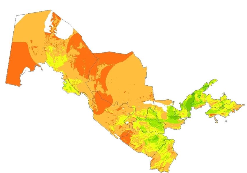
while in the 1980s and 1990s drought was observed on average twice every ten
years, in the period 2000 – 2012, extreme meteorological drought was recorded 4
times - in 2000, 2001, 2008 and 2011. According to the World Bank regional survey
[3], losses caused by the agricultural drought of 2000-2001 in Uzbekistan amounted
to US$130 million.
Droughts in Uzbekistan are regional in nature and, unlike other hazards, their impact
is not clearly delineated. To take adequate measures and develop plans to combat
drought and its impacts, it is necessary to identify the severity and spatial coverage
of droughts and their frequency as well as to analyse the resulting deficit in water
resources. We also need assessments of the impact on population, economy and
environment.
The following drought types are typical for Uzbekistan:
    - Atmospheric, or meteorological, drought is characterized by a long and
      significant lack of precipitation in comparison with the norm, high
      temperatures and a strong deficit of air humidity.
    - Hydrological drought in Uzbekistan is a shortage of water resources caused
      by snow accumulation in the mountains.
    - All other types of droughts, such as soil moisture drought, agricultural drought,
      and socio-economic drought, are the consequences of atmospheric and
      hydrological droughts.
Despite significant efforts by the government, Uzbekistan still faces the need to find
solutions to combat desertification, land degradation and drought, and aims to
develop responses and actions to prevent and mitigate drought risks to ensure
sustainable livelihoods and food security in the country.

2. Drought Indicators. Approaches to Estimate and Forecast Drought in
   Uzbekistan
Drought estimates and forecasts in Uzbekistan are carried out by Uzhydromet,
based on data from systematic observations of the characteristics and parameters of
the climate system. Uzhydromet has an extensive network of meteorological,
hydrological, agrometeorological observations (which is a stable basis for early
warning and effective response. The observation network is being modernized and
remote sensing and reanalysis data are also used for drought assessments and
forecasts.
Analysis and review of numerous publications [5, 6, 7, 8, 11, 12, 14, 16, 27, 36, 37,
38], made it possible to identify a variety of drought indices used in the country both
within the framework of scientific research and implemented in international projects,
both for forecasting and assessing the degree and intensity of droughtsg (Table 1).

Таble 1. Drought indices applied in Uzbekistan

                                                                                     2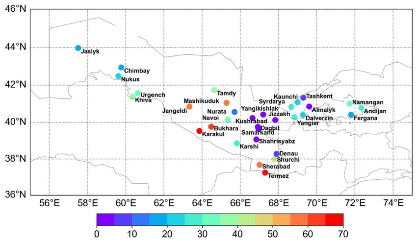
№         Drought index           Тyp               Drought degree and intensity
                                   e
1. Vapor-pressure      deficit,   А       50-60             61-70    71-80 gPa      > 80 gPa
   (Е), gPa                                gPa               gPa
                                          weak         average         strong             very
                                                                                         strong
2. Aridity index                  А     AI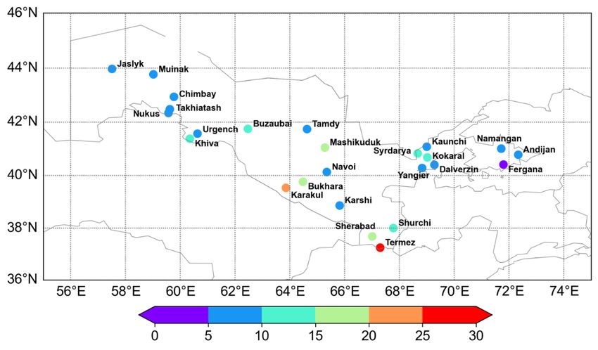
temperature above 40°C negatively affects population health, growth and
development of agricultural crops, and causes high transpiration from plants.
To assess atmospheric drought, field monitoring data from 32 representative
meteorological stations are used and results are published anually.
An effective drought management is possible only with appropriate preparedness, on
the basis of carefully developed proactive mitigation measures. Important in this
context are skillful long-term forecasts of meteorological parameters like air
temperature and precipitation, which are the basis for predicting atmospheric and
hydrological droughts.
However, despite globally ongoing efforts, the effectiveness and justification of long-
term and ultra-long-term forecasts is still low. Justification of monthly and seasonal
forecasts of temperature and precipitation anomalies is slightly higher, but also
insufficient for making effective and timely decisions. Particular difficulties in long-
term forecasting arise in continental regions of moderate latitudes, where the natural
variability of temperature and precipitation is high, which is also typical for the
Central Asian region. In modern conditions, long-term forecasts of climatic
parameters is a symbiosis of the traditional synoptic method with numerical and
statistical forecasting methods. In Uzhydromet, the official method of long-term
weather forecasting is synoptic-statistical, and additionally, statistical methods of
forecasting for the season are used as advisory methods, which makes it possible to
find general patterns in the formation of weather conditions for long periods of time.
Hydrological drought is estimated and projected based on river flow and water
availability forecasts for the vegetation period (April-September). The basis for
hydrological forecasts is information on the formation of snow cover and
accumulation of precipitation in the mountains. Hydrological drought indicators
criteria are given in Table 1.
Estimates and forecasts are carried out on the basis of field and satellite data using
the Automated Information System for Hydrological Forecasts (AISHF). Realistic
modeling results allow using this system to estimate the response of water resources
to possible climate change, based on climate scenarios [27].
The results are given as:
 - Information about accumulation of precipitation and snow reserves in the
     mountains (early January and February).
 - Preliminary forecast for early March.
 - Forecast of river flow (early April).
 - Forecasts are specified with forecasts for the second and third quarters and
     forecasts of average monthly water discharge [8].
Agricultural drought. Agricultural drought monitoring is based on a comprehensive
assessment of the impact of hydrological and meteorological drought on agriculture,
taking into account the precipitation deficit, actual and potential evapotranspiration,
changes in the level of groundwater and the level of reservoirs.
Based on the results of agrometeorological observations with a step of one decade,
databases are created for assessing dry conditions, taking into account their main
components (atmospheric and soil moisture droughts), and bulletins are published,
including:
    - number of days with relative air humidity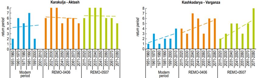
- number of days with maximum air temperature> 40°;
     - reserves of productive moisture under winter crops and cotton in soil horizons
       0-20, 0-50, 0-100 cm.
Remote sensing data is widely used for:
  − agricultural land monitoring;
  − operational assessment of the degree of agricultural and pasture land
     degradation;
  − operational assessment of snow cover in the zone of Amudarya and
     Syrdarya.
To assess impact of climate change on water resources and formation of dry years,
the climatic scenarios REMO-0406 and REMO-0507 developed by the German
Research Centre for Geosciences in Potsdam are used, which make it possible to
project the distribution of the expected future air temperature and precipitation values
for the period up to 2099 with a daily resolution [16]. Climatic scenarios show
consistent trends in air temperature increase relative to the base period (1971-2000)
throughout Uzbekistan and practically unchanged precipitation with an increase in
their natural variability [16].
At present, work is also actively underway on the possibility of using/verification
global data, surch as ERA-5 reanalysis data - temperature, precipitation, relative
humidity, and vapor pressure deficit (VPD) for calculating drought indices [13] and
SPEI.

3.   Drought Early Warning System
The Drought Early Warning System (DEWS) developed by Uzhydromet is a tool for
assessing, monitoring, warning, alerting and decision-making in the event of low
water and drought in the basins of the main Central Asian rivers: Amudarya and
Syrdarya. DEWS allows to determine the volume of expected water flow in the upper
reaches of the mountain rivers of Uzbekistan, located in the zone of natural flow
formation. Predicting water content of rivers in the zone of intensive use of runoff is a
rather complicated issue, since the river is experiencing a strong anthropogenic load.
For this, new methods and approaches for DEWS have been developed [37-39].
The objective of DEWS is to provide decision makers and the public with information
about possible droughts in advance. With the support of UNDP, the DEWS was
tested in the flow formation zone (Kashkadarya region) and is currently being
adapted for the flow dispersion zone (Karakalpakstan) of Uzbekistan [16, 17].
At present, it allows to obtain a qualitative assessment of the expected river flow,
and to determine whether sufficient water resources will be available or drought is
expected, and to define quantitative characteristics of water reserves for a particular
object [17].
The degree of expected low water and drought is a criterion for the adoption of
certain action plans to mitigate consequences of the expected drought. The reliability
and timeliness of forecast information should be sufficiently high, since in the event
of large-scale droughts, large areas of the country may be at risk, and in addition, on
the basis of this information, the authorities will be able to adjust the strategy for
managing available water resources, which will incur significant costs.

                                                                                        5
In general, the structure of the DEWS [9, 16, 17, 37-40] includes the following
components:
 • Biophysical data of the territory.
 • Estimates and forecast of low water and drought.
    − Indices: Pedya Index, SPI, Snow Reserves Index,
    − Models of snow cover formation, runoff from glaciers, and runoff
      transformation.
 • Awareness and data dissemination.
 • Recommendations for mitigation.

4. Physical and Socio-economic Characteristics of Uzbekistan
4.1 Physio-geographical Profile
The Republic of Uzbekistan is located in the center of the Eurasian continent, within
the Amudarya and Syrdarya rivers. It shares borders with Kazakhstan, Kyrgyzstan,
Tajikistan, Turkmenistan, Afghanistan. Total length of the borders is 6221 km, total
area is 448.9 thousand km2.
The country occupies a large territory with a complex variety of surface and relief.
Desert areas make up 78.8% of the territory, which includes the Kyzylkum and
Aralkum deserts formed as a result of degradation of the Aral Sea. In the east and
southeast of the country, the plains pass into the spurs of the Tien-Shan and Gissar-
Alay mountain systems with highly dissected relief - these are 21,2% of the country's
area.
The climate of Uzbekistan is arid and continental, with hot and dry summers and
short cold winters, characterized by large temperature differences between day and
night, winter and summer.

Distribution of atmospheric precipitation over the territory is extremely uneven,
closely related to the location of mountain systems, the altitude and the exposure of
slopes (Fig. 1). An increase in precipitation is observed in the foothill and mountain
areas, especially on the windward slopes. However, in general, the whole area of
Uzbekistan belongs to the arid zone.

                                                                                    6
Figure 1. Distribution of annual precipitation amounts over the area of
Uzbekistan (in mm).
Climate features are caused by a combination of three main factors - solar radiation,
general atmospheric circulation and topography. In the warm season, a high level of
solar radiation in Central Asia creates conditions for the formation of vast heat areas,
especially over the deserts (Karakum and Kyzylkum). The strongly heated air over
the plains of Uzbekistan is dry, therefore, in the summer period of the year the
conditions for drought formation are often created. The absolute maximum air
temperature in summer in the desert regions of Uzbekistan can reach 45-49°C and
more. The average annual air temperature in the plains of Uzbekistan at present
time (1990-2018) is on average 14.9°С, the warmest month is July (28.8°С), the
coldest month is January (0.9°С). The increase in air temperatures over the area of
Uzbekistan occurs against the background of high natural variability, which causes
significant interannual fluctuations (Fig. 2).
Т, °С
18
17
16
15
14
13
12
11
10
9
1950 1960 1970 1980 1990 2000 2010 2020
Figure 2. Change in average annual air temperatures since 1950 in the
southern (blue), central (red) and northern (green) zones of Uzbekistan.
Zones are defined based on latitude, therefore the central zone includes
the foothills of the Western Tien-Shan and Fergana Valley.
Although the rate of increase in average annual air temperatures somewhat slowed
down, the difference between the 30-year average values at the beginning and the
end of period (1950-2018) for the southern, central and northern zones of
Uzbekistan was 1.01, 1.34, and 1.43°С, respectively.
7The increase in the number of days with high air temperatures throughout
Uzbekistan continues. For example, in 2019, the number of days with air
temperatures above 38°C at Tashkent station exceeded the norm by almost 2 times.
The increase in amount of hot days and the decrease in air humidity cause more
frequent adverse weather phenomena, such as droughts, strong winds with a speed
of 15 m/sec and more, and dry winds, which cause an increase in dust storms. The
number of days with dust storms in the plains ranges from 10-30 to 50-64 days a
year.
The country's aquatic ecosystems represent a single hydrographic network of
permanent and temporary watercourses flowing from the spurs and ridges of the
Western Tien-Shan and Pamir-Alay, groundwater resources and a unique combination
of desert and humid territories, united by common sources of water supply - the
Syrdarya and Amudarya rivers.
Surface runoff of rivers. The main water resources of Uzbekistan are surface runoff
of the Central Asian transboundary rivers - Amudarya and Syrdarya, their tributaries
and Kashkadarya and Zarafshan rivers. River runoff of Amudarya and Syrdarya is
characterized by significant intra-annual and long-term irregularities, and in a dry
year it is 23 km3 less than in a year of average water availability. High-water years
come periodically after 6-10 years and have duration of 2-3 years, but more often
there are low-water periods observed after 4-7 years and having a protracted nature
- up to 6 years. The main flow of the Amudarya river is formed on the territory of
Tajikistan and of the Syrdarya river on the territory of the Kyrgyz Republic. This is the
reason for Uzbekistan's dependence on transboundary water sources. The average
long-term water resources of the national (internal) rivers of Uzbekistan are
estimated at about 11.5 km3/year, which satisfies about 18% of total water demand
of all economy sectors.
The volume of available water resources of Uzbekistan for the conditions of seasonal
regulation of the Amudarya runoff and long-term regulation of the Syrdarya runoff
(taking into account 11.5 km3 of the runoff of its own rivers) is 63.02 km3 according to
the interstate Agreement between Kazakhstan, Kyrgyzstan, Uzbekistan, Tadjikistan
and Turkmenistan 1. The cyclical nature of fluctuations in the river runoff and long
periods of low water complicate the economic use of water sources, especially for
irrigated agriculture in the lower reaches of the Amudarya river [19].
Lakes and reservoirs. In addition to small rivers, also lakes belong to the inland water
resources. There are about 520 natural lakes on the territory of Uzbekistan, mainly
with water surfaces not exceeding more than 1 km2. Natural floodplain and deltaic
lakes are located in the valleys of local rivers, most of which owe their origin to the
erosion-accumulative activity of rivers. Mountain lakes, usually of dammed or glacial-
moraine origin, are located at an altitude of 1700 - 4000 m above sea level and are a
potential reserves of clean, fresh water, the volume of which is estimated 60 km3 [45].
As a result of the development of irrigated agriculture, many artificial reservoirs have
been formed due to collector-waste waters. Over 269 desert depressions with the
area of 739 km2 in the middle and lower reaches of the Amudarya river are filled with
1
Agreement between the Republic of Kazakhstan, the Kyrgyz Republic, the Republic of Tajikistan, Turkmenistan and the Republic
of Uzbekistan on Cooperation in the Field of Joint Management on Utilization and Protection of Water Resources from Interstate
Sources http://www.icwc-aral.uz/statute1.htm
8drainage water. In the middle reaches of the Syrdarya river, there is the largest
system in Uzbekistan, the Arnasay system, which unites Aydarkul, Tuzkan and
Upper Arnasay lakes. The volume of water in these lakes of anthropogenic origin is
estimated 40 km3; water in the lakes is mineralized, however, suitable for fishery and
maintaining biodiversity.
The largest natural lake, the Aral Sea, half of which belongs to Uzbekistan, was the
fourth largest lake in the world until the 1960s. Currently, there are two fragments of
the sea left - in the north and west with a remaining water volume of about 10%
compared to 1960. Mineralization of water increased tenfold and reached 25-30 g/l in
the Northern part of the sea and 100 g/l in the Western one, and became unsuitable
for habitation of most of the endemic species. The Aral Sea disaster, the result of
many years of anthropogenic activity, is not only an ecological, but also a socio-
economic problem for communities living along its former banks.
In Uzbekistan, there are 56 water reservoirs [45] operated to solve irrigation, energy
and fishery problems. But since water reservoirs represent the flow of rivers
redistributed within a year, they are not classified as water resources.
Groundwater is a significant component of Uzbekistan's water resources.
Groundwater is widespread in the mountainous regions, and artesian basins are
found on the plains. The sources of groundwater supply and formation of their
resources are filtration canal losses from watercourses, infiltration of irrigation water
and atmospheric precipitation. Operational reserves of fresh and brackish
groundwater in Uzbekistan are around 6.147 km3/year. Groundwater is used in the
national economy as the main source of drinking water supply, water supply to
industry, for irrigation of pastures, and partly for land irrigation. The volume of
groundwater used is estimated to 5,319 km3/year, which is on average 10% of the
total water consumption.
Return water is an additional source of available water resources, but on the other
hand, its quality poses a serious threat to aquatic and terrestrial ecosystems. The
largest volume of return water is generated from irrigation. In 2017 and 2018, the
collector-drainage flow, respectively, was 28.7 km3 and 23.5 km3. The share of
collector-drainage runoff in the total volume of return water from all consumers and
water users is about 90% in the Amudarya basin and over 55% in the Syrdarya
basin. The main contribution to return waters come from irrigation in the Amudarya
river basin - 87.9%, in the Syrdarya river basin - 56.2%. Such high volume of return
water from irrigation is caused by large filtration losses from canals and irrigated
fields.
Water resources available for use. The distribution and management of the
resources of Amudarya and Syrdarya transboundary rivers, and keeping principles of
regional water allocation and proportions of the established water intakes, are
ensured by the regional Agreements on Cooperation signed by the Heads of State in
the Aral Sea basin. The responsibility for making decisions on management and
distribution of water resources is entrusted to the Interstate Commission for Water
Coordination of Central Asia (ICWC), which coordinates activities of the Basin Water
Association “Syrdarya” and Basin Water Association “Amudarya”, in accordance with
the adopted Agreements [48, 49].
9In accordance with interstate water allocation, the yearly water resources allocated
to Uzbekistan are 59.2 km3 (including 24.1 km3 for the Syrdarya basin and 35.1 km3
for the Amudarya basin) (Table 2).
Таble 2. Approved volume of water resources for Uzbekistan, km3
River River Small Total Groundwater Collector- Total
trunk rivers drainage flow
Syrdarya 10.49 9.42 19.91 1.59 2.60 24.10
Аmudarya 22.08 10.41 32.49 0.30 2.31 35.10
Total 32.57 19.84 52.41 1.89 4.91 59.20
Source: Scheme of IWRM in the Syrdarya (1983) and Amudarya (1984) river basins,
Sredazgiprovodkhlopok taking into account the clarification of the Vodproekt
association (1996)
When the water content of the rivers is higher than the calculated supply of excess
water, the volumes of water in excess of the specified limits must be accumulated in
water reservoirs and directed to improve the ecological situation in the Aral Sea
basin regions. When the water content of the rivers is lower than the calculated
water supply, water intakes of the countries of Aral sea basin are subject to
proportional reduction.
According to the State Committee on Statistics, total land resources of the country
amount to 44.896,9 thousand ha, of which 44.410,3 thousand ha are in use by
enterprises, organizations and citizens. The land, like other natural resources of
Uzbekistan, is a state property and a nationwide wealth, as well as a subject to
rational use and it is protected by the state.
The division of land resources of the Republic according to economic purpose is due
to differences in functions that the land performs for certain purposes. The main
categories of land use in the Republic of Uzbekistan are given in Table 3.
The largest categories of land used are (i) agricultural land (46.1%); (ii) forest land
(21.7%),
(iii) reserve land (27.6%) within three types of ecological landscapes - deserts,
steppes and mountains, covering about 95% of the country's territory. Agricultural
land occupies 25.6 mln.ha, of which 21.6 mln.ha are occupied by low-productive
pastures and hayfields, located in desert and semi-desert zones and are very
sensitive to water shortage. Irrigated arable land, the most valuable and
multifunctional category of land and the main means of agricultural production,
accounts for 4.3 mln.ha, and 0.745 mln.ha are boghara. The main products of
irrigated crop production are cereals, cotton, vegetables, potatoes, melons, fruits,
berries, grapes and other types of products. Two crops dominate among the others -
cotton and wheat, but for the period 2010-2017 cotton sowing decreased by 55.2
thous.ha, and the area under orchards and vineyards, vegetables, fodder and other
food crops increased significantly.
Table 3. Land use categories of Uzbekistan
№ Land use categories Total area
10Thousand ha %
1 Agricultural purpose 20481,1 46,1
2 Settlements 214,1 0,5
3 Industry, transport, communication, defense 914,5 2,1
4 Environmental, health and recreational 75,9 0,2
purpose
5 Historical and cultural purposes 6,2 0
6 Forest fund 9636,9 21,7
7 Water fund 831,4 1,9
8 Reserve land 12250,2 27,6
Total 44410,3 100,0
Source: 3NC (2016), according to data of the State Committee on Statistics of the
Republic of Uzbekistan
The natural ecosystems of the country's arid and semi-arid regions are historically
prone to natural salinization and are threatened by the spread of moving sands, dust
storms and dry winds, exacerbated by the lack of water resources.
The main systems in land use are grazing, irrigated and rainfed agriculture. Pasture
farming is based in regions with low natural resource potential, and its technological
cycle is extensive and completely dependent on natural forage conditions. It is
multicultural in structure and concentrated mainly in the desert and semi-desert
(81%) and piedmont semi-arid regions (12%), and the rest falls on mountain (5%)
and alpine (2%) pastures. Pasture lands are characterized by low productivity of 2-3
c/ha; the yield is unstable and depends on the amount and mode of precipitation,
therefore it fluctuates over the years and seasons.
Forests in Uzbekistan are characterized by low forest cover (6.8%), differ
significantly in their composition and are subdivided into sandy (84%) and
mountainous forests (12%), and only 2% of the area falls on floodplain and valley
forests. Forests are the most important factor in maintaining biological diversity,
sequestration and storage of carbon dioxide with a potential of 2.53 million tons per
year [6]. According to data of the State Committee on Statistics during 2000-2018,
the forest area has increased by 2.44 times due to increase in desert forests (saxaul
and shrubs), and reforestation on desert land (about 39% of the total reforestation).
The most serious environmental problems threatening the country's natural
ecosystems are increasing soil and water salinization, wind and water erosion,
grazing of pastures and deforestation, loss of species and agrobiodiversity. Land
degradation, soil erosion and over-cultivation lead to atmospheric CO2 accumulation
and affect regional climate. Increasing dangerous phenomena, including droughts,
become more frequent and increase instability of agricultural production and
negatively affect the life of rural population.
Special attention should be paid to the problems of the Aral Sea and the Aral Sea
region. The Aral Sea is located in Central Asia, on the border of Kazakhstan and
Uzbekistan. The water resources of Central Asia are concentrated in two largest
transboundary rivers: Amudarya with an average discharge of 78.5 km3/year and
11Syrdarya - 37.1 km3/year. These rivers originate in the mountains and descend into
the plains, crossing the deserts towards the Aral Sea.
Shrinking of the Aral Sea is considered one of the most serious anthropogenic
ecological crises of the 20th century. The problem that arose during the life of one
generation, in terms of environmental, climatic, socio-economic and humanitarian
consequences poses a direct threat to the regions sustainable development, health,
gene pool and the future of livelihoods in the region. The causes of the Aral Sea
disaster are a significant population growth, intensive development of irrigation
agriculture, land development, construction of large hydrotechnical and irrigation
facilities without taking into account environmental consequences. As a result, over
the past 50-55 years, the following consequences can be observed:
− The water volume has been reduced by more than 30 times
− The sea area has decreased almost 9 times
− The sea level has dropped by more than 29 m
− The coastline has receded by hundreds of kilometers.
The Aral Sea crisis zone directly covers the territories of Turkmenistan, Kazakhstan
and Uzbekistan, as well as indirectly - Tajikistan and Kyrgyzstan. In Uzbekistan, the
Republic of Karakalpakstan and the Khorezm region are in the ecological disaster
area, corresponding to 38.7% of the total area of the country.
On the exposed part of the Aral Sea on the territory of Uzbekistan and Kazakhstan,
on the northwestern extremity of the Karakum and Kyzylkum deserts, a new Aralkum
sandy-saline desert, with an area of 38,000 km2, has appeared [46]. During drought
years, population and ecosystems are particularly stressed in this area.
4.2 Socio-economic Profile
The population of Uzbekistan is 33.9 million people as of January 1, 2020, of which
50.3% are men, 49.7% are women. The urban population is 50.5%, the rural
population is 49.5%. From the total population of the Republic, 30.3% are younger
than the working age, 59.5% are in the working , and 10.2% are older than the
working age.
In 2017, the "Strategy of Action for Five Priority Areas of Development of the
Republic of Uzbekistan in 2017-2021" was adopted according to a Presidential
Decree. It is the most important program document for the development of all
economy sectors, including agriculture, for the medium- and long term.
Over the past 15 years, there has been a growth in the gross domestic product
(GDP) in the country, so in 2019 the GDP of the Republic of Uzbekistan in current
prices amounted to 511 838.1 billion soums compared to 2018. In 2019, GDP growth
was 5.6% against 5.4% in 2018 and 4.5% in 2017, while the growth of the GDP
deflator index slowed down to 19.2% in 2019 against 27.5% in 2018 and 19.4% in
2017. The structure of the country's GDP according to type of economic activity is
given in Table 4.
It should be noted that the economic sector most vulnerable to drought is agriculture,
which jointly with forestry and fishery, contributes 28.1% of gross added value to the
GDP [50]. The export of agricultural products brings about 20-25% of the total export
income to the Republic. Currently, more than 180 types of agro-food products are
12exported to 80 countries of the world, thereby contributing about 10% to the external
income of Uzbekistan [51].
Agriculture provides about 27% of employment of the economically active population
[52]. In the aggregate incomes of citizens, the share of income from agriculture in
different regions ranges from 35 to 60%, and in rural areas this figure exceeds 70%
everywhere.
Table 4. Structure of the country's GDP acoording to type of economic activity
Economic activity 2000 2010 2013 2014 2015 2016 2017 2018
Gross added value of 100 100 100 100 100 100 100 100
industries
Agriculture 34,4 19,8 19 33,8 34,1 34,0 34,0 32,4
Industry 16,2 26,7 25,9 20,2 20,2 20,6 22,2 26,3
Construction 6,9 6,6 6,5 5,7 6,0 6,0 5,7 5,7
Services 42,5 46,9 48,6 40,3 39,7 39,4 38,1 35,6
Source: State Committee on Statistics of the Republic of Uzbekistan, www.stat.uz
The industry is demonstrating sustainable growth rates. The volume of agricultural
production in 2019 amounted to 215.7 trillion soums, or 102.7% to the corresponding
period of 2018 (Table 6).
Due to the arid, continental climate, crop production almost entirely depends on
irrigation. Today, irrigated agriculture, which accounts for only 9% of total area of the
country, already consumes over 95% of total water intake. Besides that, the demand
for water to ensure food security for the 34 million citizens will increase due to high
population growth. As a result of population growth, the area of arable land per
capita has decreased from 0.195 ha to 0.129 ha over the past 25 years. More than
half of farms are engaged in cultivation of wheat and cotton, the rest are engaged in
livestock production, vegetable growing, melon growing, viticulture, horticulture,
beekeeping, etc. Uzbekistan is one of the world leaders in cotton production and the
main producer of fruits and vegetables in Central Asia. In 2015, Uzbekistan became
one of 14 countries to receive awards for achieving the Millennium Development
Goals in the field of food security.
5. Drought Characteristics
To assess atmospheric drought, Uzbekistan uses the number of days with a vapor-
pressure deficit of ≥50 hPa, calculated on the basis of ERA-5 reanalysis data [13].
Figure 3 shows the number of days with atmospheric drought relative to the average
over the period. We can see how the average value changed relative to these two
periods, on average the number of days increased by 8 days, which also
demonstrates a long-term trend. If we take the years with an excess of the relative
average value as dry years, then the most prolonged droughts occur
in 2014-2015 and 2017-2018 [54].
13On average, the number of days with atmospheric drought in Surkhandarya region is
75 days, Bukhara region - 55 days, Navoi region - 50 days, Kashkadarya region - 25
days. A large number of days a year with air temperature above 40°C is also
observed in these regions (Figures 4 and 5) [54].
Figure 3. Dynamics of the average number of days with drought in Uzbekistan
per year [54]
Figure 4. Number of days with a vapor-pressure deficit of ≥50 hPa
averaged over the growing season from 1980 to 2018 (according to ERA-
5) [54]
14Figure 5. Number of days with air temperature ≥40°С averaged for the
period 1980-2018 (according to ERA-5) [54]
Hydrological drought. Due to fact that the flow on the rivers in Uzbekistan is
predominantly regulated headwaters with a minimal anthropogenic impact were
analysed for the period 1960-2016/2017.
The indicator of “water availability in %” was taken as the indicator of hydrological
drought, which demonstrates the degree of aridity.
Figure 6 shows, for example, long-term series of water availability for the basins of
the Surkhandarya and Kashkadarya rivers, where we can see more frequent cases
of droughts.
Surkhandarya, Shurchi
100
80
60
40
20
0
1960
1963
1966
1969
1972
1975
1978
1981
1984
1987
1990
1993
1996
1999
2002
2005
2008
2011
2014
2017
Kashkadarya, Chirakchi
100
80
60
40
20
0
1960
1963
1966
1969
1972
1975
1978
1981
1984
1987
1990
1993
1996
1999
2002
2005
2008
2011
2014
2017
15Figure 6. Trends in the drought index (water availability) for the period 1960-
2017
Figure 7. Frequency of low water on the Kashkadarya and Karakulja
rivers in the modern period and according to climatic scenarios
[16]
Figure 7 shows the results of a scenario analysis estimating the recurrence rate of
dry years at present and in the future [16, 39]. The results of this approach showed
that under the conditions of warming expected according to climatic scenarios
against the background of increased natural variability, a decrease in runoff is likely,
and there is also a tendency for the increase in extreme water content years in the
basins of some rivers.
For assessing vulnerability and risks of desertification and drought the
following analysis was performed:
- Zoning of the territory according to aridity index [41]
- Assessment of areas prone to desertification, land degradation and drought [15,
41]
- Assessment of agriculture and water sector vulnerability to climate change.
Zoning of the territory according to aridity index [41]. To assess the drylands of
Uzbekistan, the Harvgreaves method was chosen based on the classification shown
in Table 1.
As shown in Figure 8, almost the entire territory of country is located in the arid area,
with 25% of the land in the extra-arid zone, and 68% in the arid and semi-arid zone.
163%
4%
25%
20%
48%
sub-humid dry sub-humid
Figure 8. Distribution of the territory of Uzbekistan accroding to aridity classes
[41]
The main part of the extra-arid zone falls on the Republic of Karakalpakstan (14%)
and the Navoi region (7.5%), while the arid and semi-arid zone accounts for 23.1% in
the territory of Karakalpakstan, and 17.4% in the Navoi region (Fig. 9).
An assessment of areas prone to desertification, land degradation and drought
was performed by Rhakmatova[15].
The assessment is based on indicators of soil erosion, soil salinity, fertility, aridity,
precipitation, and vegetation vigour (NDVI). A score-based approach was used to
assess the integral component. Each indicator was mapped and graded on a five-
score scale. Then the cumulative amount of these indicators for all classified factors
allowed creating an algorithm for assessing type and degree of desertification.
Taking into account the obtained values, an integral/complex map was obtained on
susceptibility to desertification, land degradation and drought (Fig. 9).
As follows from the figure, more than half of the territory of the Republic (51%) is
affected by desertification and drought. These areas are located in the steppe zone,
but most are in the desert or semi-desert zone.
25% of the territory of Uzbekistan undergoes a strong degree of desertification and
drought, it includes the areas of sandy deserts, the Aral Sea region and western part
of the Ustyurt plateau.
The areas characterized by weak and insignificant degree of desertification and
susceptibility to drought occupy 8% of the entire territory and are located in the
foothill and mountainous regions.
1/6 of the country is moderately affected by desertification and drought. As a rule
these correspond to the irrigated zones of the plains.
172% 6%
25%
16%
51%
weak or absent insignificant moderate
significant strong
Figure 9. Map of the territory's susceptibility to desertification and drought [15]
Assessment of the vulnerability of the agricultural and water sector to climate
change [42]. In terms of agriculture and water, vulnerability is influenced by a range
of social, economic and environmental factors that influence the ability to withstand
the effects of changing conditions. To assess the vulnerability, this study adopts a
combined index approach known as the Climate Change Vulnerability Index [43],
based on indicators reflecting a variety of vulnerability aspects. The following most
significant indicators were selected for the assessment:
- trend of climate change,
- vegetative cover,
- mineralization of irrigation water,
- land fertility,
- salinization area,
- erosion,
- degradation of pastures,
- percentage of irrigated land,
- arable land area per capita,
- rural population,
- population density,
- use of water for irrigation,
- public health,
- percentage of the working-age population,
- GDP per capita,
- crop yield.
Each of these indicators has its own units of measurement and scales. For
comparability, indicators were normalized from 0 to 1 as input to the combined
vulnerability index (Fig. 10).
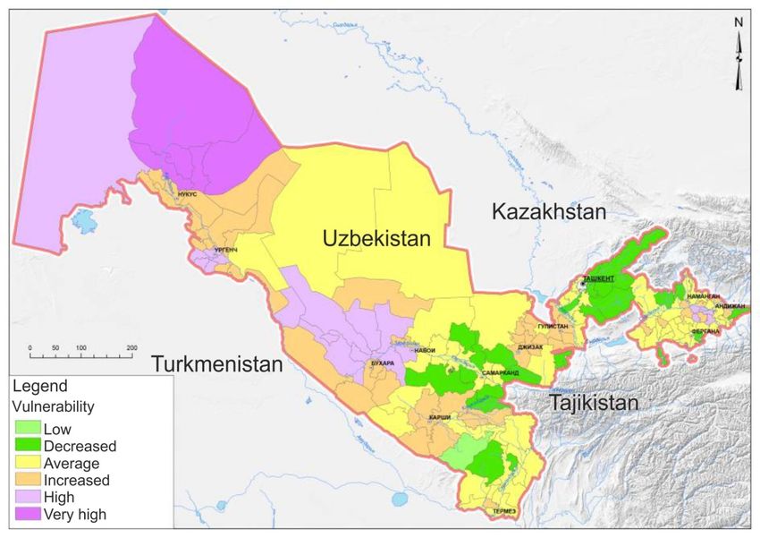
In all planning zones, agriculture and water sectors are vulnerable to climate change
in varying degrees. On 40% of the territory, vulnerability is assessed as high and
very high, on 55% as medium and high. A very high degree of vulnerability is typical
for the Aral Sea region, which is due to the increased climatic impacts as a result of
degradation of the Aral Sea. For certain areas of the Fergana Valley, increased
vulnerability is determined by high sensitivity as a result of heavy load on natural
resources and shortage of land resources due to population density (maximum 1188
18people/km2 in Asaka district of Andijan region). The areas located in the foothill part
(Tashkent, Samarkand, Kashkadarya and Surkhandarya regions) are characterized
by a reduced vulnerability.
Figure 10. Vulnerability of agriculture and water resources to climate
change [42]
Based on these assessments, the most vulnerable zones are the Aral Sea area and
theKhorezm and Bukhara regions. A high or significant degree of vulnerability is also
found in some areas of Fergana Valley, while the most favorable areas are
Tashkent, Samarkand, Kashkadarya and Surkhandarya regions.
6. Drought Impacts
Due to its geographical location Uzbekistan is significantly vulnerable to the impact
of climate change. In recent years, we witnessed more and more severe droughts
with negative impacts on all types of water bodies, which disrupts their natural
functions, as well as the health and well-being of the population and economy. The
agriculture sector is especially vulnerable.
According to Third National Communication on Climate Change of the Republic of
Uzbekistandata (2016) [6], climate change will inevitably aggravate the current
situation in terms of drought frequency and impacts, including (i) a reduction of
glaciation and seasonal snow cover in the mountain river basins; (ii) an increased
flow variability; (iii) an increased region/volatilits, which will lead to water losses in
irrigated areas and affect irrigation rates. A decrease in available water resources
and an increase in water consumption are expected in all sectors.
Water resources. From 1957 to 2010 the rate of reduction in the area of glaciation
varied from 0.1 to 1.65% per year. This degradation process, even if it accelerates
19as a result of increasing summer temperatures, will continue for several decades,
since the ice reserves are significant (567 km3) [1,9,21].
The melting of glaciers results in a temporary increase of the available water
resources [22, 35]. However, by 2050, reductions of 2-5% in the Syrdarya river basin
, and of 10-15% in the Amudarya basin are possible, as well as an increase in the
interannual variability of runoff in the river basins. In extremely warm and dry years
the runoff in the basins of the Syrdarya and Amudarya rivers may decrease by 25-
50%. The expected reduction in river runoff will lead to an acute water deficit
especially in dry years.
Low runoff, high temperatures and resulting moisture deficits have a negative impact
on ecosystems: desertification processes are aggravated, water resources are
reduced, and the quality of water in terms of salinity and hydrobiological indicators is
significantly deteriorating. A change in the hydrological regime disrupts the aquatic
biota of lake systems and wetlands, and reduces the productivity of terrestrial
ecosystems, which is clearly visible on lakes and wetlands in the lower reaches of
the Amudarya river and the Aral Sea region, which in turn makes the delta tugai
forests vulnerable.
The main threat to the preservation of wetlands of the Amudarya delta is the
unstable hydrological regime and absence of outflow, resulting in the drainage and
degradation of water and near-water ecosystems, the disturbance of the ecological
balance and the loss of socio-economic functions. The hollows of the Big Aral have
turned into salt lakes. In autumn 2009, satellite images showed the complete
disappearance of the Big Aral eastern basin. In recent years, water in the eastern
basin of the Aral Sea appears for a short time when water is discharged from the
Small Aral basin and large inflows through the Amudarya watercourse happen.
The analysis of the consequences of the 2000-2001 drought of the Karakalpakstan
and Khorezm region shows that the most dramatic declines in agricultural production
occurred due to insufficient planning, forecasting and control over water resources at
the regional, republican and local levels [21, 26].
In fact, the 2000-2001 drought formed gradually, was unusual due to a lack of
precipitation combined with high levels of evaporation caused by hot weather over
several years. Precipitation levels reached only 40-60% of the norm, which led to an
extreme reduction in river runoff (35-40% of the average). River runoff in the lower
reaches of the Amudarya river was recorded low - which led to decrease in water
supply in Karakalpakstan by 20-30% and in Khorezm region by 35-80%, compared
to the approved water limit.
The 2000-2001 drought was a catalyst for desertification and environmental
degradation. By the end of 2001, the lake systems and wetlands in the northern part
of Karakalpakstan, with an area of about 160 thousand ha, were almost completely
dry. As a result of the disappearance of the wetland habitat, 46 species were entered
in the Red Book of Uzbekistan in 2000-2001. The groundwater level in areas
affected by drought dropped to 10-15 meters, as a result, most artesian wells run
dry. The quality of water has deteriorated [21].
Hydrological and socio-economic effects of drought were felt until the end of 2003,
while precipitation and agricultural production returned to normal in most areas in
2002 [21, 27].
20Agriculture. As already mentioned, agriculture is one of the most significant sectors
of economy for Uzbekistan, with a contribution of 28% to the country's GDP. 50% of
population are rural residents. In 2017, 3.7 million people worked in the agricultural
sector (27.2% of the total number of employees) [23]. Crop production is almost
completely dependent on irrigation, and over 95% of the sown area is irrigated land,
with 3.4 mln.ha occupied for growing annual crops (cereals, barley, wheat, rice, corn,
cotton, potatoes, vegetables) [22] . Cotton and grains are the most important
agricultural crops in Uzbekistan. Fruits and vegetables are grown in significant
volumes. Besides that, milk, silk and livestock are produced.
Due to the increased incidence of droughts, local communities and farmers
experience significant problems associated with searching of and additional costs for
alternative sources of water and yield losses, which lead to a decrease in income.
The Urban population is experiencing the impact of drought as an increase in
agricultural products’ prices.
In the event of droughts, crops are suppressed, crop shortages and/or loss of crops
occur over large areas. The measures taken in 2000-2001 were of an extraordinary
nature; one of the forced measures was to ban cultivation of rice as the most water-
intensive crop in some areas. Losses of grain crops during the years of severe
drought in 2000-2001 accounted for 14-17%, and for other crops - on average from
45-52% to 75% (the lower reaches of Amudarya). Orchards and vineyards are
particularly susceptible to reduced yields when water is scarce.
The expected loss of yield of major agricultural crops by 2050, , will average 35-50%
according to 2016 Third National Communication on Climate Change of the Republic
of Uzbekistan estimates [6]. Due to increased evaporation cotton yield losses will
vary from 4% (2030) to 10% (2050). For winter wheat, rice and other food crops,
yield losses will range from 4% (2030) to 7-14% (2050). For rainfed agriculture in
unfavorable weather conditions, the crop yield will decrease to 50% or more. Due to
the rise in air temperature, the spring-summer vegetation of all types of vegetation
on desert pastures will begin 5-10 days earlier and the total evaporation will
increase, which will lead to a more rapid decrease in soil moisture reserves and,
accordingly, biomass.
By 2050, a complex of negative factors can lead to a shortage of agricultural
products by 10-15% compared to the modern period. Population growth, combined
with a decline in soil fertility and declining water resources due to climate cha give
reason to expect a future aggravation of problems in the agricultural sector and
hence a reduction in food security [28,10].
Cattle breeding. Pasture-based cattle breeding is concentrated mainly (81.4%) on
desert pastures, the productivity of which is very low (0.1-0.27 t/ha). In unfavorable
years, the yield of pastures decreases by 2-3 times, while the load on pastures is
especially increasing.
The impact of drought on the cattle breeding sector is manifested through changes in
pasture productivity, fodder stocks, grazing conditions and animal health. During the
2000-2001 and 2011 severe droughts, overgrazed pastures around rural settlements
and villages were completely deprived of water supply. As a result, the harvesting of
forage grasses has been reduced by more than half. In some of the affected areas of
Karakalpakstan, drought has forced farmers to sell a significant portion of their herds
or agricultural equipment [18, 19, 21].
21The expected increase in air temperatures will further intensify heat loads in summer
and increase their duration, which will cause a decrease in weight gain, and from a
certain level even weight loss in animals.
The cattle breeding sector in Uzbekistan is developing at a rapid pace with a growing
livestock population, which entails an additional load on pastures, overgrazing, a
decrease in feed capacity and a degradation of vegetation. Consequently, the cattle
breeding sector will need to make decisions with a focus on the main risks (supply of
feed, condition of pastures; availability of additional stocks of feed; heat stress),
assess its vulnerability and identify priority mitigation measures.
At present, the Government's efforts are aimed at further developing the agricultural
sector by reforms and transformations to mitigate land degradation and drought, and
by improving the reclamation of irrigated land, reconstructing irrigation and drainage
infrastructure. Particular attention is given to diversifying agricultural production (with
transition to drought-resistant and less water-intensive crops, creation of value
chains), as well as the restoration of pastures and forests. In this respect, the
agricultural vulnerability assessment needs to be updated, taking into account the
latest changes in the sector, using new methodologies and approaches, and the
analysis of the 2018 drought impacts. This should involve all stakeholders and local
communities, and identify targeted mitigation measures to increase the
preparedness and resilience to droughts.
Fishery. During drought years in the Amudarya delta the loss of the bioproductivity
of biocenoses and aquatic biota of reservoirs as a result of critical changes in water
regime led to total death of populations of commercial fish in the region, undermining
the resource base of fisheries. In the entire history of fishing, the smallest catch of
fish in the Amudarya delta was in years following the drought 2003 and 2004. Fifty
farms of Karakalpakstan were on the verge of bankruptcy, leasing over
60 thous.ha of lake systems.
Social impacts. In addition to environmental and economic damage, droughts have
significant social impacts. In years of drought, the rural population is especially
vulnerable to the lack of water. Combined with high temperatures this leads to the
death of plants, a decrease in yield, the drying up of small reservoirs and the
pestilence of fish, problems with grazing and, accordingly, a drop in income. The
population is prone to exacerbation of cardiovascular diseases, acute intestinal
diseases and skin melanoma.
Social assessments identify a need of local communities to improve the quality of
drinking water and water for cooking and sanitation during periods of severe drought
ADB (2005). All of them have to spend a significant share of their income on
purchase and storage of drinking water. In addition to monetary costs, the population
bears significant social costs, which are expressed in serious health risks, poor
nutrition, etc. [30, 31].
According to UNDP (2007) [32], the following population groups are extremely
vulnerable to water scarcity:
Farmers downstream. Farmers located in the lower reaches of rivers, as well as
in the end spots of the irrigation network and/or remote from the irrigation
network. The most vulnerable are dekhkan farms on soil of poor quality and land
difficult to reclaim, and in sufficient access to irrigation water.
Women are predominantly rural residents. Water scarcity, especially during
22periods of severe drought and environmental degradation, greatly increase their
vulnerability. Old-age pensioners, disabled people, single mothers, pregnant
women, families with many children are also in a vulnerable position. It is
especially difficult for these populations to cope with water scarcity and
adaptation measures.
According to UNDP estimates, during the years of severe drought in 2000-2001 the
most affected population in the regions of Uzbekistan (about 600,000 people)
needed food, drinking water, assistance in the supply of agricultural resources, the
cost of which amounted to US$19 million. The analysis shows that in 2001, about
79,000 farms in Karakalpakstan and 21,000 farmers in Khorezm were unemployed,
and migration outside Uzbekistan in search of better living conditions increased.
7. Drought Management
7.1 Existing Drought Policy and Legislation
In response to extreme droughts and climate variability affecting the country's
territory, the government is making significant efforts to prevent and mitigate the
consequences. Activities are carried out at international, regional and national levels.
Uzbekistan is a party to the following international agreements directly or indirectly
affecting drought issues:
− United Nations Framework Convention on Climate Change (UNFCCC)
− Paris Agreement
− UN Convention to Combat Desertification, Land Degradation and Drought
(UNCCD)
− UN Convention on Biological Diversity (UN CBD)
− Convention on the Conservation of Migratory Species of Wild Animals
− Ramsar Convention on Wetlands
− Vienna Convention for the Protection of the Ozone Layer
− Montreal Protocol on Substances that Deplete the Ozone Layer.
In 2015, the Government of Uzbekistan made commitments to implement the global
2030 Agenda for Sustainable Development. In October 2018, 16 National
Sustainable Development Goals and
125 Targets were adopted. The government is working to integrate the Sustainable
Development Goals and Targets into national, regional and sectoral development
strategies and programs. To date, out of 125 national SDG targets, 105 (or 84%)
have been covered in more than 190 regulatory, programmatic and strategic
government documents. In the field of ecology, Uzbekistan prioritizes mitigation and
adaptation to climate change (including under the Paris Agreement) with a special
focus on the Aral Sea region, conservation and careful use of water, land and energy
resources, as well as biodiversity conservation (SDG 13, 14 and 15). Uzbekistan
also adopted a National Action Plan for implementation of the Sendai Framework for
Disaster Risk Reduction 2015-2030 [54].
The SDGs include SDG Target 15.3, which calls for “combating desertification,
restoring degraded land and soils, including lands affected by desertification, drought
and flooding, and striving to achieve a land degradation neutrality - LDN by 2030”.
23Uzbekistan, under Goal 15, Target 15.3, adopted a voluntary target "Share of land
that degrades (irrigated and not irrigated) over the total land area".
The Government of Uzbekistan supported the provisions of the joint
WMO/UNCCD/FAO Programming Document "National Drought Management
Policies" and “Best Practices for National Drought Management Program".
Implementation of this document will shift the emphasis from response measures
(actions in a crisis situation) to proactive measures to ensure preparedness for
drought.
Uzbekistan participates in a number of initiatives on regional level in the field of
disaster risk reduction and emergency prevention [34]:
− Action Plan for implementation of the Sendai Framework for Disaster Risk
Reduction
2015-2030 in Central Asia and South Caucasus region, December 2016
− Climate Adaptation and Mitigation Program for Aral Sea Basin, April 2016
− Call for action by the participants of the Second Central Asian Conference on
Climate Change, 3-4 April 2019
− EC and WB "Strengthening Financial Resilience and Accelerating Risk
Reduction in Central Asia" Program, 2019-2023
− Subregional Action Program of the Central Asian Countries to Combat
Desertification in the Context of the UNCCD
− Framework of Cooperation on Strengthening Regional Cooperation of
Disaster Management Authorities of Central Asian and South Caucasus
region, January 30, 2015.
In terms of drought policy, after signing the UN Convention to Combat Desertification
and Drought in 1999, the National Action Program to Combat Desertification was
developed and implemented, which was updated in 2014.
The updated National Action Program (NAP) to Combat Desertification (2014)
aims to prevent and reverse land degradation and drought, and, where possible,
restore DLDD-prone land in order to support the country's efforts to improve
prosperity and ensure food and environmental sustainability.
The objectives of the NAP are aimed at:
− Increasing national awareness of DLDD issues and their impact on socio-
economic development.
− Ensuring response measures and actions to challenges, threats and
restrictions associated with land degradation, desertification and drought.
− Compliance with the priorities and coordinated responsibility of key
organizations in decision-making and effective implementation of the country's
obligations under the UNCCD in the context of combating DLDD.
− Development of national capacity to integrate DLDD issues into national and
sectoral plans and monitoring system to implement coherent action with local
population to address factors causing DLDD.
24You can also read


