Vanguard Commercial GEOINT - of - Trajectory Magazine
←
→
Page content transcription
If your browser does not render page correctly, please read the page content below
2018 ISSUE 1

 THE OFFICIAL MAGAZINE      OF THE UNITED STATES GEOSPATIAL INTELLIGENCE FOUNDATION

Vanguard
     The

   of
Commercial
  GEOINT              From self-driving cars and
                     “drones as a service” to
                      crowdsourcing exercise
                      routes, the commercial world
                      continues to leverage GEOINT
                      in new and creative ways                                > The Algorithm Age
                                                                              > Q&A: Jeff Jonas

                                                                     USG IF.O RG   T R AJ ECTORY   1
MANAGE YOUR DATA.
DISCOVER ANSWERS.
MAKE DECISIONS.
Analysts in today’s world are expected to have the right
information at their fingertips to answer urgent questions
at a moment’s notice. Jagwire allows analysts to spend         TM

less time searching for the right data and more time
providing answers for time-critical operations.

harrisgeospatial.com/trajectory
©2018 Harris Gespatial Solutions. All rights reserved. All other marks are the property of their respective owners.
Image courtesy of DoD. Use of DoD images does not constitute or imply endorsement.

contents                                                                                                      2 01 8 I S S U E 1

                                                                                                                      08 THE VANGUARD OF
                                                                                                                      COMMERCIAL GEOINT
                                                                                                                      From self-driving cars and “drones
                                                                                                                      as a service” to crowdsourcing
                                                                                                                      exercise routes, the commercial
                                                                                                                      world continues to leverage GEOINT
                                                                                                                      in new and creative ways
                                                                                                                      By Rob Pegoraro
IMAGE COURTESY OF MAPD

                         This screenshot of MapD’s live Tweetmap visualization shows the most recent two weeks of data, with approximately 400 million tweets cached for exploration.

                         FEATURES                                      02 | VANTAGE POINT                     20 | MEMBERSHIP
                                                                       Rapidly advancing                      PULSE                                 24
                         14 THE                                        technologies demand that
                                                                       GEOINT professionals
                                                                                                              Harris Corporation,
                                                                                                              Deloitte Consulting,
                         ALGORITHM AGE                                                                        and USGIF Individual
                                                                       continuously seek to
                         In the defense and                            enhance existing skill
                                                                                                              Member Andrea
                                                                                                              Keilholtz
                         intelligence communities,                     sets and add new ones
                         machine learning has                                                                 23 | HORIZONS
                                                                       04 | INTSIDER
                         graduated from nascent                                                               Reading List, Peer
                                                                       Achieving accurate,                    Intel, USGIF Events
                         to operational                                reliable AI; YPG gives                 Calendar
                         by Matt Alderton                              back; GEOINT shared with
                                                                       800+ students during                   24 | PERSPECTIVE
                                                                       GEOINT Community Week                  Q&A with Jeff Jonas
                                                        06
                                                                                                                                                                 ON THE COVER:
                                                                             TRAJECTORYMAGAZINE.COM                                                              Strava’s Global Heatmap displays
                                                                                                                                                                 water activities such as swimming,
                                                                           WEB EXCLUSIVE                              EXTENDED                                   surfing, and kayaking in Sydney,
                                                                           NGA’s Safety of Navigation                 INTERVIEWS                                 Australia. Strava is one of four
                                                                                                                                                                 companies on the leading edge of
                                                                           mission provides critical                  Read the full-length Q&As
                                                                                                                                                       TRJ-053

                                                                                                                                                                 commercial GEOINT featured in this
                                                                           guidance to mariners and pilots.           from this issue.                           issue’s cover story.
                                                                                                                                                                 Image courtesy of Strava
vantage point

GEOINT’s Expanding                                                                                                USGIF CHAIRMAN OF THE BOARD

Applications                                                                                                      The Honorable Jeffrey K. Harris
                                                                                                                 USGIF CEO AND EXECUTIVE EDITOR
                       As we embark upon 2018, despite                  If you and your organization have                Keith J. Masback
                       utterly frigid cold here in the north-      benefitted from USGIF over the years,                 MANAGING EDITOR
                       east United States, the GEOINT field        then please consider the many ways                       Kristin Quinn
                       remains hot. The GEOINT Revolution          in which you can give back so we may                kristin.quinn@usgif.org
                       continues to churn at what seems to be      continue our work as the convening
                                                                                                                              EDITOR
                       an exponential pace. Rapidly advancing      authority for GEOINT Community                          Brad Causey
                       technologies and ever-evolving appli-       discussions as well as our enduring                bcausey@glcdelivers.com
                       cations across increasingly diverse         support toward thought leadership. We
                       sectors demand that GEOINT profes-          value your participation in our events,                 ART DIRECTOR

                       sionals continuously seek to enhance        your time devoted to our working                  Gretchen Kirchner Rund
                                                                                                                      grund@glcdelivers.com
                       existing skill sets and add new ones.       groups, your investment in membership
                           For 14 years, USGIF has led the         and sponsorship, and your charitable                  ASSISTANT EDITOR
                       charge for the creation of GEOINT           donations. We remain thoughtful                    Lindsay Tilton Mitchell
                       opportunities in higher education,          stewards of the resources you entrust             lindsay.mitchell@usgif.org
                       and for creating myriad avenues for         to us. The Foundation’s work is more                  EDITORIAL INTERN
                       professional development. Though we         important than ever as the concept of                 Andrew Foerch
                                                                   GEOINT rapidly expands.                            andrew.foerch@usgif.org
                                                                        This issue of trajectory speaks quite
                                                                   clearly to that expansion. The commer-
                                                                   cial GEOINT cover story provides four
                                                                   case studies that illustrate the appli-                  PUBLISHER
                                                                   cation of GEOINT to challenges and                      Jordan Fuhr
                                                                   opportunities outside the traditional               jordan.fuhr@usgif.org
                                                                   national security arena. A second
                                                                                                                             AD SALES
                                                                   feature documents the transition of
                                                                                                                         Joseph Watkins
                                                                   machine learning from the theoretical               jwatkins@naylor.com
                                                                   to the applied within the defense
                                                                   and intelligence communities. And
                                                                   on our website, you will find a web
^ Graphic             have a strong record of accomplish-         exclusive profiling the critical but
  facilitation being   ment in these areas, in some ways I feel    little-known Safety of Navigation
  conducted during                                                                                               Trajectory is the official magazine
  USGIF’s 2017         the Foundation is just beginning to hit     mission at the National Geospatial-            of the United States Geospatial
  GeoAcademic          its stride, and our capacity continues      Intelligence Agency.                          Intelligence Foundation (USGIF).
  Summit at the        to grow.                                         Best wishes to all for a healthy,
  Foundation’s                                                                                                       LETTERS AND COMMENTS
  headquarters in          The beginning of 2018 brings            happy, and rewarding 2018. As always,
                                                                                                                     Email trajectory@usgif.org.
  Herndon, Va.         another GEOINT Community Job Fair,          I eagerly look forward to seeing you
                       the newest installment of the State and     in our conference rooms and hallways,                  SUBSCRIPTIONS
                       Future of GEOINT Report, another fan-       in and around your workplaces, and at                 Sign up for free at
                       tastic small satellite event, informative   our events—to include our return                   trajectorymagazine.com.
                       and engaging GEOINTeraction Tuesday         to Tampa in April for the GEOINT                     USGIF MEMBERSHIP
                       gatherings, and rich discussions            2018 Symposium.                                For information on becoming a
                       fostered among USGIF committees and                                                      member, email membership@usgif.org.
                       working groups.
                                                                                                                              TWITTER
                           All of this is made possible thanks
                                                                                                                          @trajectorymag
                       to our organizational and individual
                       membership programs, advertising
                       via our multimedia platforms, and
                       revenue from events—including
                       sponsorships, advertising, exhibits,
                       and attendee registrations. Addition-
                       ally, USGIF’s EdGEOcation Giving
                       Campaign has opened up an important         KEITH J. MASBACK | CEO, USGIF                   PUBLICATION MANAGEMENT
                       opportunity for philanthropic support.      @geointer                                    847-205-3000 | GLCDELIVERS.COM

2   T R AJ EC TO RYM AGAZ I N E .C OM   20 18 I S S U E 1
comments

LETTER TO THE EDITOR
Dear trajectory team,                                                               REDACTIONS
Andrew Foerch presented a concise narrative of the Google Earth trajectory
(“The Genesis of Google Earth,” 2017 Issue 4). Missing, however, was the            • The 2017 Issue 4 feature, “The Genesis of Google
inaugural 2001 contract with Keyhole Inc. by the United Nations Environment           Earth,” was remiss in not mentioning all three com-
Programme (UNEP). This inaugural UNEP contract represented the Keyhole                panies involved in Google Earth’s transition to open
team’s first and important milestone.                                                 source. Thermopylae Sciences and Technology, NT
                                               This achievement formally and          Concepts, and Navigis—three longtime Google part-
                                           visibly put these gentlemen on             ners—supported GEE’s transition to open source.
                                           the international stage at both the
                                           International Conference on Spatial      • The 2017 Public Safety Special Edition feature,
                                           Information for Sustainable Devel-         “GEOINT for Policing,” incorrectly attributed a quote
                                           opment, October 2001, Nairobi,             to James McGinty of the Police Executive Research
                                           Kenya as well as the World Summit          Forum. The statement was actually made by Craig
                                           for Sustainable Development, August        Fischer of the Police Executive Research Forum.
                                           2002, Johannesburg, South Africa.
                                           This grand debut into the global civil   • The 2017 Public Safety Special Edition feature,
society, outside the military-industrial society, demonstrated the potential of       “Roadmap for Nationwide Geospatial Data Sharing,”
“digital Earth” technology for managing and preserving the Earth’s ecological         incorrectly noted Chris Vaughan’s title as FEMA’s
goods and services as well as effectively addressing disaster response and            chief information officer and said he was a FEMA
resilience.                                                                           first responder following Hurricane Katrina.
    The UN, along with myriad organizations and citizens, has followed this tra-      Vaughan is the agency’s geospatial information
jectory toward using spatial science and information for improving the human          officer, and was deployed in support of FEMA’s
condition and protecting our biosphere.                                               Urban Search and Rescue Team, providing on
    Keep up the great journalism.                                                     the ground geospatial support in New Orleans
                                                                                      following Katrina.
—Dr. Tim Foresman, International Center for Remote Sensing Education
(Dr. Foresman was UNEP’s chief scientist responsible for initiating the Keyhole      We regret these errors.
Inc. contract, and the former Digital Earth chairman for NASA.)

                                                                WHEN “ONE-SIZE-FITS-ALL”
                                                                DOESN’T MEET YOUR NEEDS
                                                                Riverside Research develops data-driven AI
                                                                solutions tailored to your unique requirements.

                                                                Learn how at riversideresearch.org/AI or
                                                                contact us at OICML@riversideresearch.org.
C O M M U N IT Y N E W S ,
                                                                                                 E V E NTS , A N D E D U C ATI O N

                                                                                                                                    USGIF NEWS
                                                                                                                                    GEOINT COMMUNITY NEWS
            USGIF WORKSHOP SERIES                                                                                                   EDUCATION
                                                                                                                                    APPLICATIONS
                                                                                                                                    CIVIL

                                                                                                                               Caption

                                                                                                                                                                                     PHOTO BY
  Achieving Accurate, Reliable AI
^ From left to right,    USGIF’s Machine Learning & Artificial     professionals, Melissa Planert, director   time, alert mechanisms, confidence

                                                                                                                                                             PHOTO COURTESY OF NGA
  Machine Learning        Intelligence Working Group gathered       of NGA’s Office of Analytic Tradecraft,    metrics, and metadata tagging.
  & Artificial Intelli-
  gence workshop          dozens of experts for its November        said it’s not hard to imagine a time           Dr. Curt Davis, director of the Cen-
  panelists Dr. Darryl    workshop to explore the opportunities     when analysts won’t be able to work        ter for Geospatial Intelligence at the
  Murdock, Dr. Todd
  S. Bacastow, Dr.
                          and challenges intelligent technologies   with all of the data available to them.    University of Missouri, said AI is still in
  Curt H. Davis, and      present. The daylong session at the       Planert predicted computer vision          the early stages, but warned the United
  Melissa Planert.        National Geospatial-Intelligence Agency   would be most important for the            States is trailing behind the rest of the
                          (NGA) attracted more than 275 people      GEOINT Community.                          global community. Davis personally
                          and was one of many events hosted as          Planert said AI presents the pos-      catalogued articles on deep learning
                                                 part of USGIF’s    sibility for around-the-clock analysis     in three IEEE remote sensing journals
                                                 GEOINT Commu-      that identifies patterns of life and       from 2015 to 2017. He discovered that
             To learn more about                 nity Week.         trends, and can also enable anticipa-      out of approximately 100 articles, 71
      USGIF’s Machine Learning &                     In the first   tory intelligence. She also outlined       percent were authored by China, while
      Artificial Intelligence Working
                                                 panel on the       what analysts will expect from AI tools,   11 percent were authored by European
      Group, visit usgif.org/
                                                 implications of    including: an intuitive user experience,   nations, the rest of the world authored
      community/committees/
      machinelearning.                           machine learning   a simple feedback mechanism to train       13 percent, and only five percent origi-
                                                 for GEOINT         algorithms, increased accuracy over        nated from the U.S.

  4     T R AJ EC TO RYM AGAZ I N E .C OM   20 18 I S S U E 1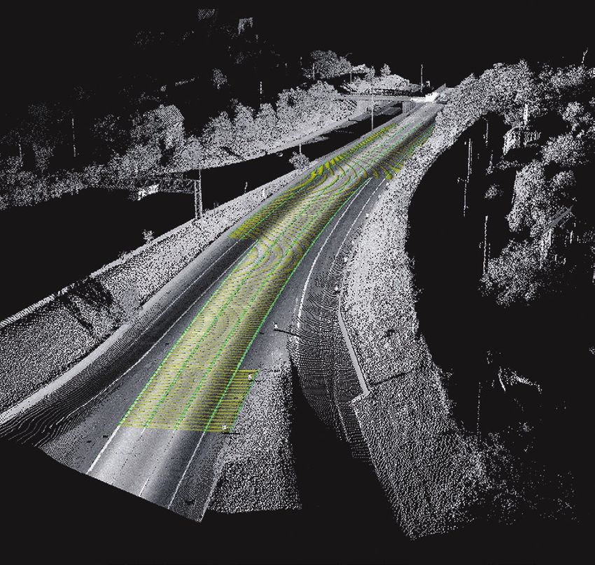
“One in    30 companies that claim they’re doing machine learning and
    AI today are actually doing it.” — Dawn Meyerriecks, CIA

    David Aha, lead of the Naval Research Lab’s Adaptive Systems Section, said
there are currently many common concerns that AI technologies are opaque,                         PROCRASTINATION TOOLS
unreliable, corruptible, spoofable, and overhyped.
    William “Buzz” Roberts, director of automation, artificial intelligence, and            DOT
augmentation at NGA, said conversations about how, where, and when to appro-                                    Map and share your world with
priately create training data as well as to test and implement AI aren’t occurring                              DOT. Users drop “dots” to mark
enough. He suggested rather than broad implementation, each mission should                                      places they’ve visited on the
take its own approach to reach information assurance.                                                           app’s base map, labeling the
    Regarding overhype, Roberts said, “There’s a huge set of misperceptions that                                locations with hashtags and
‘We can automate that.’ We need a deep level of understanding by all parties to                                 comments for friends and visi-
get to 98/99 percent reliability.”                                                                              tors. Anything can be a dot, from
    Dawn Meyerriecks, the CIA’s deputy director of science and technology,                                      bathrooms to ice cream par-
gave an afternoon keynote in which she also warned about hype, describing AI                                    lors—when you are done placing
as “emergent.”                                                                                                  dots, the app creates a unique
    “One in 30 companies that claim they’re doing machine learning and AI today                                 map file from your entries. Use
are actually doing it,” she said.                                                                               cases range from finding and
    Meyerriecks added she sees much potential for AI, but warned against ruining                                reviewing bakeries to creating
the technology’s reputation by over-promising and under-delivering.                         a personal list of your city’s best views.
                                                                                            dotisfun.com

                                                                                            Map of Life
                                                                                            Explore global biodiversity
                                                                                            and learn about your favorite
                                                                                            flora and fauna with Map of
                                                                                            Life. This database covers
                                                                                            30,000 species worldwide
                                                                                            and includes trend indicator
                                                                                            maps, species range maps,
                                                                                            location-based wildlife maps,
                                                                                            lists, and more. Users can
                                                                                            record their own observations
                                                                                            in the app and share them with
                                                                                            friends and other researchers.
                                                                                            The tool is perfect for the out-
                                                                                            doorsman or nature enthusiast looking to forgo
                                                                                            bulky guidebooks.
                                                                                            mol.org

USGIF’s Young Professionals Group (YPG) hosted a holiday cruise on the Potomac River, and                      Dark Sky
collected new gifts for Toys for Tots while onboard.                                                           Dark Sky uses GPS technology
                                                                                                               and predictive analytics to
       YPG                                                                                                     provide an accurate, hyperlocal
Young Professionals Give Back                                                                                  weather forecast for exactly
                                                                                                               where you stand. Whether it’s
In support of George Mason University’s (GMU) GIS Day events, members                                          light rain beginning at precisely
of USGIF’s Young Professionals Group (YPG) spoke on a panel to current                                         12:05 p.m., snow in an hour,
GMU students enrolled in geospatial science courses. Participants included                                     or hurricane-force winds this
Heather FitzGerald, NGA; Justin Franz, USGIF; Ian Harvey, Pricewaterhouse-                                     weekend, minute-by-minute
Coopers; and Robert Miller, HawkEye 360. Each panelist shared their career                                     notifications alert users to the
journeys and advice on pursuing opportunities in the GEOINT Community.                                         information they need. The app
Following the panel, YPG continued the conversation at a networking recep-                                     features fluid radar animations
tion sponsored by Boundless.                                                                the user can drag back and forth to view a storm’s
    YPG celebrated the holidays in December with a chartered cruise on the                  progression, as well as global weather maps for
Potomac River. Members had the opportunity to enjoy the holiday season                      precipitation and temperature.
while taking in views of Washington, D.C. While onboard, the group also                     darksky.net/app
collected new gifts for Toys for Tots.

                                                                                                                  USG IF.O RG   T R AJ EC TORY      5
EdGEOcation

  USGIF Shares GEOINT with 800+ Students During
  GEOINT Community Week
^ USGIF Intern         USGIF participated in many K-12-focused activities in
  Madalyn Caraway       November as part of the Foundation’s GEOINT Community
  (left) volunteered
  at a GeoPlunge        Week, which coincided with Geography Awareness Week.
  tournament in             Throughout the week, USGIF volunteers gave Intro to
  Washington, D.C.,
  where more than
                        GEOINT presentations at schools across the U.S. and Canada.
  100 students              USGIF also created a pilot Intro to GEOINT curriculum
  played the            for Kilmer Middle School in Vienna, Va. Each week over a
  geography card
  game.                 three-month period, eighth grade students learned about
                        a different GEOINT topic along with an interactive activity.
                            Additionally, USGIF sponsored and participated in Geo-
                        Plunge tournaments in Washington, D.C., and St. Louis.
                        The GeoPlunge card game teaches geographic literacy in a
                        fun way.
                            USGIF also held a satellite imagery analysis activity at
                        two community STEM events—Moorefield Station Elemen-
                        tary School’s STEM Night in Ashburn, Va., and Women In
                        Technology’s “Girls In Technology Sharing Our Success”
                        event in Washington, D.C.
                            The American Geographical Society (AGS) hosted an
> Moorefield Station   invite-only AGS Geography Teacher Fellows Program for
  Elementary            around 50 AP Human Geography teachers Nov. 18. USGIF
  School in Ashburn,
                        Director of Academic Programs Dr. Camelia Kantor mod-
  Va., held its
  annual STEM           erated a panel—“So, What’s in it for the Students?”—which
  Night, at which       provided teachers more insight on career opportunities in
  USGIF provided a
  satellite imagery     geography and geospatial sciences as well as resources for
  analysis activity.    curriculum development.

 6    T R AJ EC TO RYM AGAZ I N E .C OM   20 18 I S S U E 1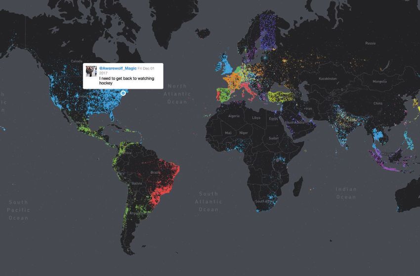
USGIF-ACCREDITED SCHOOLS

                                                                                                        NOVA IMS Receives
                                                                                                        Third Party
                                                                                                        Accreditation
                                                                                                        The NOVA
                                                                                                        Information
                                                                                                        Management
                                                                                                        School (IMS)
                                                                                                        at the Univer-
                                                                                                        sidade Nova
                                                                                                        de Lisbon
                                                                                                        received a six-year accredi-
                                                                                                        tation for its online master’s
                                                                                                        degree program in geo-
                                                                                                        graphic information systems
                                                                                                        and sciences by the Agency
                                                                                                        for Assessment and Accred-
                                                                                                        itation of Higher Education
                                                                                                        (A3ES). A3ES is a private,
                                                                                                        third-party accreditation
                                                                                                        body in Portugal. NOVA IMS
                                                                                                        became accredited by USGIF
      GEOINTeraction
                                                                                  ^ Dr. Anthony        in 2016 and is the first non-

The AI Arms Race
                                                                                    Vinci, NGA’s
                                                                                    director of plans
                                                                                                        U.S. school to achieve USGIF
                                                                                    and programs,       academic accreditation.
The United States, China, and Russia are “in an arms race for artificial            spoke about the
                                                                                    future at USGIF’s
intelligence,” according to Dr. Anthony Vinci, NGA’s director of plans              GEOINTeraction
and programs.                                                                       Tuesday event in    University of
   Vinci discussed the importance of preparing for the future in front of a         November.
                                                                                                        Missouri AI
crowd of more than 100 people in November at USGIF’s GEOINTeraction
Tuesday event, hosted by OGSystems in Chantilly, Va.
                                                                                                        Research Identifies
   Vinci pointed to recent reports in which Russian President Vladimir Putin                            Missile Sites
claimed the leader in AI would be “the ruler of the world.” Meanwhile, he said,                                        Research-
China is planning to turn AI into a $150 billion industry by 2030.                                                     ers from the
   “There are these real threats, and they’re not necessarily just the ones                                            University of
we’ve grown used to since 9/11,” Vinci said, emphasizing the importance of                                             Missouri’s Cen-
dialogue about the future among NGA, the broader Intelligence Community                                                terforGeospatial
(IC), industry, academia, and organizations such as USGIF.                                                             Intelligence
   “There’s a real possibility the U.S. could become second best—that we                                published an article in the
could lose some of these arms races,” he said. “We have all grown up in a                               Journal of Applied Remote
world in which, by far, the U.S. was the dominant GEOINT capability, even                               Sensing in October that
before it was called GEOINT. We can’t even imagine a world in which we                                  evaluated how deep learn-
aren’t, but it’s a possibility, and we need to confront that possibility and                            ing algorithms can identify
ensure it doesn’t happen. We need to remain dominant.”                                                  missile sites. The group sifted
   Vinci outlined emerging technologies with the potential to help the U.S.                             through 70 terabytes of
maintain intelligence dominance, including commercial space advances, the          China is             DigitalGlobe satellite imagery
Internet of Things (IoT), and autonomous vehicles. He added it’s important         planning             combined with surface-to-air-
the IC confront not just how it will take advantage of these new technolo-                              missile sites in areas of China
                                                                                   to turn AI
gies, but also how adversaries might leverage them.                                                     to test four deep learning
   “We have to prepare for a world where a country like China might try to         into a               models and determine which
dominate AI, where terrorists have UAVs and other autonomous vehicles
they can use for attacks, where Russia might use IoT devices or other              $150                 one performed best. This
                                                                                                        research was created as a
things for spying in our country, and where lots of countries and even non-        billion              way to automate the process
state actors have access to space,” Vinci said.                                    industry             of examining imagery for
   In some cases, he said, these things are already happening. Vinci                                    undeclared nuclear facilities
concluded with a quote from writer William Gibson: “The future is already          by 2030.             or secret military sites.
here—it’s just not evenly distributed.”

                                                                                                         USG IF.O RG   T RAJ EC TORY      7
From self-driving cars and “drones as a service” to
           crowdsourcing exercise routes, the commercial world
          continues to leverage GEOINT in new and creative ways

8   T R AJ EC TO RYM AGAZ I N E .C OM   20 18 I S S U E 1
vanguard
the BY ROB PEGORARO
of
commercial GEOINT
FIRST WE TOLD OUR DEVICES how to
locate themselves, then we gave our comput-
ers the power to parse the profusion of data
those devices generate. Now, those devices are
returning the favor by providing useful informa-
tion about the world around us. But many of us
have only begun to realize all the possibilities these
changes have opened after creeping up on us from
multiple directions.
“We sort of slouched into it,” said Dr. Todd S.
Bacastow, a professor of practice at Pennsylvania
State University. “It’s certainly been within the last
five to 10 years that we’ve begun to see this massive
amount of data and all the opportunity within it.”
USG IF.O RG T RAJ EC TORY 9Around 25 years ago, only approximately 15 percent track digits. We can certainly track where people are.”
of the information collected in the world was geo-tagged, That’s the story of how geospatial intelligence (GEOINT)
observed Dr. Steven D. Fleming, a professor of spatial has generated new perspectives on the natural and built
sciences with the University of Southern California’s Spatial environment. But the next chapter—how companies take
Sciences Institute, which is accredited by USGIF to grant these possibilities and turn them into new products and
Digital academic GEOINT Certificates. services—includes many plot twists.
maps save Now? “Most of the world’s data is geo-tagged—I think These four companies illustrate only a few of many
consumers it’s 85 to 90 percent,” Fleming said. “We know where a ways the commercial world is leveraging the power
21 billion banking transaction starts and where it ends. We can of GEOINT.
hours per
year as a
result of Teaching Cadillacs to Drive Themselves
faster, better
informed The form of GEOINT Cruise self-driving option in the 2018 CT6. The carmaker
shopping many people know turned to a Livonia, Mich., firm named Ushr to take navi-
decisions. best is the digital map— gational mapping to the next level.
for example, the latest “The difference about an autonomous driving map
Geography 2050 conference in versus a navigation map, we’re concerned about the lane
New York City focused entirely on delineators, the slope of the road,” said Chris Thibodeau,
mobility. The ability of a phone senior vice president of Ushr. “In a navigation map, none
to locate itself and then offer of that information is needed.”
directions customized to traffic Plus, an autonomous driving map needs accuracy
conditions was the stuff of science beyond what GPS can deliver—down to 10 centimeters.
fiction 30 years ago. But as impres- Ushr sent cars packed with LiDAR sensors on a tour of
sive as the digital cartography of America’s highways—220,000 miles driven since 2013.
Google and others can be, it’s not “It took us about a year and a half to collect and pro-
ayered over original LiDAR imagery,
L
precise enough to feed directly to a cess all that data,” Thibodeau said.
Ushr roadway data includes details like self-driving vehicle. In September, I had the opportunity to take a CT6 on
cross-slope, lane width, lane markings, and So Cadillac decided to commis- loan from Cadillac for a test drive from Washington, D.C.,
more, all globally geo-referenced to sub-10
centimeter accuracy. Data is available sion its own maps before it could to Cleveland, and the results were a kind of magic: Once
every 0.5 meters along the road. include its highway-only Super the CT6 recognized it was on a highway in its database,
a steering-wheel icon lit up on the dashboard to advise
me that Super Cruise was available. I’d press a button
to activate this mode, and the top of the steering wheel
illuminated in green to show the car had taken over.
Informed by its database, the CT6 stuck to a lane as
if it were a rail, slowing and accelerating as needed to
compensate for traffic around me. All I had to do was
keep my eyes focused on the road ahead—something the
car itself watched for, using an inward-facing camera to
ensure I was still paying attention.
Ushr is now looking to drive down the costs of its
mapping solution, in part by applying machine learning
techniques to recognize road features such as stop signs
and crosswalks.
“We’re also spending a good amount of engineering
resource today on basically automating those feature
identification and feature extraction algorithms,” said
Brian Radloff, Ushr’s vice president of business develop-
ment. He added this would allow Ushr to begin mapping
secondary roads.
Cadillac might not need that data—company pres-
ident Johan de Nysschen told me in 2016 that bulky
LiDAR sensors needed to detect pedestrians would not
fit with a Cadillac’s style—but Ushr has other customers
in mind.
IMAGE COURTESY OF USHR
“Some municipalities are looking at potentially using
this data [in place of conducting their own surveys] if it’s
accurate enough,” Radloff said. “When Amazon’s talking
about things like drone delivery having a very precise
HD map those drones can follow [it could] be another
kind of further-out-there application of this technology.”
10 T R AJ EC TO RYM AGAZ I N E .C OM 20 18 I S S U E 1Bringing Eyes to the Skies—For Rent
Unmanned aerial vehi- points about exactly where in the field Measure doesn’t disclose its rates,
cles, more commonly a crop is flourishing or struggling. but Lacy cited internal research
known as drones, are “A lot of them really derive from that the company’s service can
one of the most public just having the eye in the sky—not yield $7,200 in annual savings on a
symbols of GEOINT’s new era. But just the RGB, but the NDVI,” Lacy said, 10-megawatt solar facility compared
many companies that could benefit referring to the Red-Green-Blue of to traditional inspections.
from the ability of drones to extend traditional imagery and the Normal- She noted drones don’t just
human senses to places that are dif- ized Difference Vegetation Index that operate at a lower cost than manned
ficult or dangerous for humans to a near-infrared camera can produce to aircraft, they can also get lower to
reach lack the budget and expertise indicate the presence of live vegetation. the ground. The firm relies mostly
to buy their own systems. That, in turn, can allow for a more on visual and thermal cameras.
That’s where D.C.-based Mea- precise, cheaper application of fertilizer. “We are keeping a close eye on
sure comes in, offering drones and But many farmers remain skeptical. how LiDAR is evolving,” she said, but
analytical tools clients can hire “They just tend to be slow adopters added that so far costs are too high
for particular jobs. This business when it comes to technology,” she and quality is too low.
model—what it calls “Drones as a continued. “They’re really hesitant The firm also often has to deal
Service”—has given the firm exten- to drop money on all of this different with a lesser GEOINT hindrance—
sive insight into what drones can equipment.” every company seems to have its
and cannot do. Measure is more bullish about the own proprietary software. “You’ll get
“Agricultural is probably one of potential for drones to provide insight 15 different software providers that
the most overhyped applications for industries such as construction and all have a unique system,” Lacy said.
for drones,” cautioned Abigail Lacy, energy. Lacy cited solar farms as one Measure hopes automated data
Digital Measure’s vice president of sales. example, touting the ability of drones processing will cut down on its own
maps have “Anybody you talk to who’s been in to answer questions before construc- overhead, but the real “game changer”
supported the drone space for more than two tion, such as: “How productive will the would be automation of a drone’s
more than years would probably tell you that.” solar farm be?” and “Am I going to have flight—which, in turn, will require a
$1 trillion A drone’s different perspective water runoff issues on the site?” Once loosening of regulations that today
of yearly can, however, make a difference the site is in operation, drones can help ban drone flights beyond a human
sales for at the margins by gathering data identify malfunctioning panels. operator’s visual line of sight.
businesses.
Fusing Maps and Live Data
Now that so many mobile devices come than five billion records.
equipped with GPS receivers—meaning the A third demo provides a
apps on those devices can also geo-tag user look at nearly seven years’
activities—coping with the massive scale of the worth of taxi rides across
resulting data becomes a challenge. New York City, from 2009
“As the variety of channels and devices that connect to 2015. During that time,
customers, companies, and physical assets increases, so cash transactions out-
too do the ways to measure and analyze spatial informa- numbered credit, at more
MapD’s New York City taxi ride data set currently
tion,” a 2016 Forrester report observed. “One of the great than 632.1 million cash totals approximately 1.2 billion records.
challenges for effectively making use of location data has transactions versus more
been integrating it with other data sets and analysis to than 510.8 million credit—while more than 2.2 million rides were recorded as
provide deeper context and insight.” going uncharged.
That’s a big theme in the work of MapD, a D.C.-based The massive computational power provided by GPUs is critical to
firm that’s made a specialty out of integrating live data these efforts.
with maps. “GPU computing is really going to take data to the next level and analytics
One of its most fascinating demos tracks the last sev- to the next level,” said Monica McEwen, MapD’s vice president for U.S. federal
eral weeks’ worth of geo-tagged tweets around the world, customers. She pointed to how this revolution in processing power allowed
placing them on the map and color-coding them by lan- Verizon Wireless to accelerate its analysis of network problems.
guage. Users can search for keywords and hashtags or just “Historically, they had to do that in batch mode,” she said. “Today, they’re
float the cursor across countries to see what is trending. looking at that in real-time.”
For example, the large rectangle hovering over Finland Also important: Ensuring interfaces scale up to meet a density of data she
turns out to be @EveryFinnishNo, a bot that tweets out the predicted will mean “being able to display literally billions of records and
IMAGE COURTESY OF MapD
Finnish word for a new number every minute. have a response time in the milliseconds.”
Another MapD demo offers a similarly granular look “The pure volume of [data] makes it nearly impossible to present it in a
at ship movements around the U.S. from 2009 to 2015, fashion in which people can make meaningful sense of it,” McEwen said. As a
both offshore and in lakes and rivers. “Tug” is over- result, MapD’s interfaces let users easily add or remove layers of data so they
whelmingly the most popular type of vessel, with more can focus on particular variables.
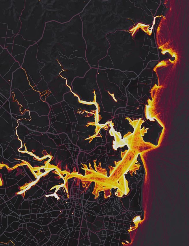
USG IF.O RG T RAJ EC TORY 11Strava’s Global Heatmap of New York City
reveals popular routes and activities.
Crowdsourcing Exercise Intelligence
Strava, a workout-tracking bike- and pedestrian-hostile roads
app popular with many in gray.
cyclists and runners, has Even in small towns like rural
a different challenge to Lincoln, Va., enough users walk,
address. Mashing up the location run, or bike to leave a dense web of WHAT’S NEXT? MEGACITIES, DRONES, AND
IMAGE COURTESY OF STRAVA
reports it gets from users can trails on Strava’s heatmap. To use SMALL SATS
inform individual Strava athletes this to get a sense of an individual’s In terms of its commercial evolution, GEOINT is barely old
looking to find popular routes on whereabouts, you’d need to know enough to run for office. What could it look like by the time
its heatmap. where they live first. this roughly 25-year-old discipline is old enough to run
That trove of data soon caught Strava Metro, launched in 2014, for president?
the attention of urban planners, offers customers not just the heat- USC’s Fleming said a larger trend—humanity’s move
and that led to a complementary map’s static view (updated once to large cities, in which the height and volume of build-
product: a database of cycling and a quarter) of overall movements ings make the traditional references of GPS unusable or
pedestrian activity over time called but also minute-by-minute data suspect—will force a switch to more resilient location tech-
Strava Metro. about how many people went in nologies that work better inside and next to large structures.
“We started hearing from one direction on one street. Again, “We’re piling up people along the coastlines of the world,
departments of transportation who the company boils its data down so we have to deal with megacities better.”
said, ‘This is cool, but we can’t see to GPS points, this time showing Many smartphone users have already seen this problem
the temporal details,’” said Brian direction and time, while removing when location-based apps lose a GPS signal, decide a
Devaney, sales and marketing lead everything else. nearby WiFi router that happens to have been moved from
for Strava Metro. “We had to figure “We do buffer for privacy,” one venue to another is just as valid, and vault the user to a
out a way to get all those GPS pulse Devaney said of the company’s spot miles away.
points and aggregate them and decision to obscure the start and Fleming also expects drones to become even more
anonymize them.” end of a workout route. on-demand, “where everyone expects them to be around
Combining the heatmap with And users can opt out of having and they’re providing things like public safety services.”
Metro required the firm to address their data used in Metro at all, But a world in which the whine of quadcopter rotors is a
privacy risks. although only “a fraction of a per- normal part of the background din may take some persua-
Part of its answer is privacy cent” have done so. sion by drone vendors.
options. Users can choose to place a Customers such as city and Fleming’s colleague Andrew Marx pointed to a different
geo-fence around a home, office, or state transportation departments form of GEOINT system: small sats.
other location, hiding it and the last as well as cyclist advocacy orga- “The advantage of a small sat is you can build up an
500 meters of a route from the view nizations use this data to plan or activity of an object,” Marx said. “You can have so many
of others. A more comprehensive push for improvements such as repeat observations.”
enhanced privacy option suppresses bike lanes and wider sidewalks, But adding this temporal dimension to GEOINT will
even more data from the feeds of then audit how the new infrastruc- require further innovation to display it. The tasks MapD
other Strava users, down to your ture performs. and Strava already face will only grow more arduous.
last name. They can learn what corridors “It’s a struggle, because we’re trying to depict things in
The company won’t say how are most busy during peak com- four dimensions,” Marx said.
many users have exercised either mute times versus on weekends,” Penn State’s Bacastow, meanwhile, warned about two
option, but many customers never Devaney said. “A lot of groups are trends people might not appreciate as much.
touch the default settings. To keep using the data to understand how One is which countries are focusing their efforts in this
their information safe as well, behavior changes after they put in area. “Many of our students in AI and deep learning are
Strava aggregates individual GPS infrastructure.” not from the U.S.,” he said, referring to a recent presen-
measurements without reference to You can imagine that this tation by the University of Missouri’s Dr. Curt Davis.
where users started and ended their data would also be enormously “Counting publications, you’d find that scholars from
workouts. The result is an alterna- attractive to such businesses as ath- other countries, such as China, have a significantly larger
tive map in which a major highway letic-wear manufacturers, but Strava number of publications than scholars from the U.S.”
like Interstate 66 in northern Vir- has chosen to limit its sales of Metro Another is how different generations view the privacy
ginia vanishes from view, while the data to organizations “working to implications of having their geo-location harvested by
bike trail next to it glows yellow but influence policy and infrastructure.” smartphone apps. Bacastow recounted a freshman semi-
leaves no hint of where along the Eschewing commercial use of nar he taught two years ago about geospatial privacy.
path one person started or ended data gathered from workout-track- “I thought students would be concerned and engaged
their ride or run. Strava’s underly- ing apps happens to line up with in a seminar about their loss of privacy,” he said. “Quite
ing maps, developed by D.C.-based one of the core privacy principles honestly, they didn’t care. For them, while they under-
Mapbox on top of cartography from put forth last year by the Future of stand the loss of their location privacy, as one student put
OpenStreetMap, automatically show Privacy Forum. it, ‘I want my pizza delivered to the right place with the
push of a button.’”
12 T R AJ EC TO RYM AGAZ I N E .C OM 20 18 I S S U E 1REVEALING INSIGHTS Radiant Solutions, a business unit of Maxar Technologies, harnesses the disruptive power of multi-source data collection, machine learning and data analytics to reveal unique geospatial information that helps our customers understand and navigate our changing planet. We reveal insights that keep our nation safe and enable smarter decisions. Visit us at www.radiantsolutions.com to learn more Object Detection Count Aircraft 85
FOR MORE THAN 33 YEARS spanning
     more than 7,000 episodes, Alex Trebek has
     been host of the popular TV game show
Jeopardy! During that time, the erudite emcee has
seen it all. He’s watched geniuses crash and burn.
He’s seen people win—and lose—millions. Perhaps
the most remarkable Jeopardy! event of which Trebek
has been a part, however, was the match wherein
Jeopardy! champions Ken Jennings and Brad Rutter
challenged Watson, an IBM supercomputer.

algorithm
                                    the

                                              age
                                                Watson had been trained to answer
                                            trivia questions using a combination of
                                                                                        competitors. That it could trounce adult champions a mere
                                                                                        four years later is a testament to the power of artificial intel-
                                            data mining, pattern recognition, and       ligence (AI) and machine learning. AI and machine learning
                                            natural language processing. During         have matured even further in the seven years since Watson’s
                                            the course of three televised matches       victory, graduating from novelty to necessity—especially
                                            that aired in February 2011, Watson         for the defense and intelligence communities, which are
                                            destroyed its human challengers, win-       simultaneously researching and operationalizing machine
                                            ning $77,147 compared to Jennings’          learning in order to win an entirely different kind of compe-
                                            $24,000 and Rutter’s $21,600.               tition: what some senior military officials are calling an “AI
                                                “I didn’t give it the kind of serious   arms race.”
                                            thought I should have in terms of
                                            examining the technology required to        THE CASE FOR COGNITIVE COMPUTING
                                            have a computer that will understand        So-called “deep learning” is the machine learning technique
                                            the nuances and subtitles we present        that most interests the defense and intelligence communi-
                                            with our clues in Jeopardy!,” Trebek told   ties. Although the computer science behind it is complex,
                                            TIME magazine. “It wasn’t until I saw       its premise is simple: A computer receives a question
                                            the computer play that I thought, ‘Holy     and identifies an array of possible answers. To determine
                                            smokes, this is serious stuff.’”            which answer is correct, it uses hundreds of algorithms
                                                When it was first developed in          to examine the available evidence, including what type of
                                            2007, Watson took two hours to              information is available and how reliable it is. Using neural
                                            answer a single Jeopardy! question          networks that simulate human brain function, each piece
                                            and struggled to beat even child            of evidence is weighted against the rest. Ultimately, the

14   T R AJ EC TO RYM AGAZ I N E .C OM   20 18 I S S U E 1
In the defense
and intelligence
communities,
machine
learning has
graduated from
nascent to
operational
BY MATT
ALDERTONcomputer ranks the possible answers from most to least The CIA has approximately 140 pilot projects underway,
likely and puts forth the most promising one. Human oper- with the goal to transfer machine learning from researchers
ators subsequently tell the computer whether it was right and data scientists to customers and operators.
or wrong, at which point it self-edits its algorithms. Each “The range of applications varies widely and applies
time the computer answers a question it “learns” something to most of CIA’s components. Data understanding is an
new, which over time allows it to reach more accurate and overarching objective, including the extraction of patterns
reliable conclusions. impossible to find with standard or traditional manual
This capability is especially attractive to the U.S. techniques. Examples include change detection across
Department of Defense (DoD) as it pursues what it calls the different timeframes, and amplifying imperceptible motion
“Third Offset.” patterns from pixels,” Liu reported.
Consider, for example, the U.S. Air Force. “We look at Multimedia analytics is an area of emphasis, according
neural networks like they’re wingmen,” said Capt. Michael to Liu: “This includes natural language processing tasks
Kanaan, director’s action officer for U.S. Air Force Intelli- such as automatic machine translation and transcription,
gence (AF-A2), which envisions a future where U.S. airmen and image and video processing tasks such as object and
are assisted by machine sidekicks that constantly analyze activity characterization.”
the world around them, à la Star Wars’ R2-D2. “We’re The Intelligence Advanced Research Projects Activity
training our R2-D2 to be right there with us. In that way, (IARPA) is working on numerous programs designed to
machine learning acts as a decision aid. deliver machine learning capabilities to the IC, according
“Machine learning It can shrink the time radius of our OODA
loops: observe, orient, decide, and act.”
to IARPA Program Manager Hakjae Kim.
The program about which Kim is most enthusiastic is
is going to help Simply put: The increased speed and the Functional Map of the World (fMoW) Challenge, which
tell the analysts certainty it can gain from machine learn-
ing will allow the U.S. to remain ahead of
concluded in December and in February will award cash
prizes to the top five participants who developed algorithms
where to look. If its adversaries. “AI and machine learning to detect and categorize buildings, structures, and land uses
you’re looking provide us insight at speed and scale that
we otherwise would not have,” Kanaan
in satellite imagery—a challenging task due to the some-
times low resolution and high variability (e.g., time of day,
for a white truck, continued. “It has second-, third-, and weather, etc.) of satellite images. To help participants train
why spend time fourth-order effects that create decision their algorithms, IARPA published one of the largest-ever
advantage for us.” publicly available satellite image datasets, annotated with
looking at hours of There are practical benefits as well as more than a million points of interest across approximately
video where there’s strategic ones. 60 categories such as hospitals, schools, lighthouses,
“One of the main challenges [the bridges, and cellphone towers.
no white truck? Intelligence Community (IC) faces] is “We’ve invested a lot of money to create inputs and out-
Let’s just give the data volume,” said Central Intelligence puts that can be used to train deep neural nets,” explained
Agency (CIA) spokesperson Jonathan Kim, who hopes the algorithms produced during the fMoW
analysts the video Liu. “For example, thousands of terrorist Challenge will activate a community of developers who con-
where the white videos are uploaded on a daily basis. tinue to apply their expertise toward IC objectives. “As more
Therefore, there is a need to detect, people become familiar with IC challenges, they’ll be able to
truck is.” characterize, and triage data in a scalable use [the dataset we created] to help us solve our problems,
—KEVIN BERCE, BUSINESS manner. Machine learning enables and which will be a bigger contribution than the algorithms that
DEVELOPMENT MANAGER, NVIDIA
assists our officers to maximize their time come out of the competition.”
in solving problems and making high- Like IARPA, NGA is leveraging external expertise to
level decisions.” acquire and scale its machine learning capabilities—most
Data-processing fatigue is another important chal- notably through its Global Enhanced GEOINT Delivery
lenge machine learning can help solve. “For example, it (Global-EGD) contract with DigitalGlobe, whose Geospa-
is known that human visual recognition performance tial Big Data Analytics (GBDX) platform is a marketplace
decays with time. In contrast, well-trained algorithms can through which customers can acquire machine learning
sustain constant performance and process data 24/7,” algorithms created by DigitalGlobe and third-party develop-
Liu said. “Combining both human and machine-driven ers for use with DigitalGlobe imagery.
decision-making is the optimal way to solve problems. “The Global-EGD contract’s largest and most attractive
Specifically, using machines to automatically solve basic, asset is the EnhancedView Web Hosting Service, which
repetitive, and time-consuming tasks, such as finding small provides near-real-time access to over 1 billion square
objects in image collections. The summarized data then kilometers of DigitalGlobe imagery,” explained NGA Pro-
serve as the initial pre-culled data set needed to solve highly gram Manager Brian Bates. “We’ve worked very closely with
complex intelligence problems.” DigitalGlobe to build an interface between the Enhanced-
In other words, machine learning makes a force mul- View Web Hosting Service and GBDX so our analysts can
tiplier of computers, achieving maximal analytic capacity access … algorithms to run over different areas of interest
with minimal human resources. that correspond with their mission set.”
An acquisition, design, delivery, and demonstration
IC ADVANCES activity completed in summer 2017 unearthed a number
AI’s benefits have been apparent for decades. As the technol- of algorithms NGA analysts are currently applying across
ogy advances, the IC is moving quickly to test and field new missions, according to Bates. There’s a water detection
machine learning capabilities. algorithm, for example, to identify water inundation after
16 T R AJ EC TO RYM AGAZ I N E .C OM 20 18 I S S U E 1natural disasters; a soil detection algorithm to identify con-
struction activity; and ship and plane detection algorithms
to detect unusual air and marine activity. As of November,
USGIF WORKING GROUP
NGA is using a material identification algorithm that can TACKLES MACHINE
detect manmade paints and polymers and a vehicle detec- LEARNING CHALLENGES,
tion algorithm that can identify cars and trucks, as well as
distinguish between them.
OPPORTUNITIES
“[Analysts] receive alerts in the interface as well as email
alerts … indicating that the threshold they have set for USGIF established its Machine Learning & Artifi-
activity or number of objects has been met or exceeded, cial Intelligence Working Group in March 2017.
and what area that happened in,” Bates said. “Eyes-on-im- Co-chaired by Michael Rampino, principal at
agery analysis is a time-consuming process, and if you’re RMA Consulting; Kevin Berce, business develop-
doing missions like search or monitoring it can be ment manager at NVIDIA; and Ted Josue, director
extremely tedious.” of intelligent systems and machine learning
research at Riverside Research, its charter is to
DEEP LEARNING AT DoD build a community of interest by focusing on:
The DoD is pursuing machine learning capabilities as
enthusiastically as the IC. The Army Research Lab (ARL), > Near-term hard problems of interest to the
for example, is exploring a number of ways to enable deep GEOINT Community that might be addressed
learning at the tactical edge. by machine learning and AI technologies
“This kind of computing is going to be embedded wher- and methods.
ever we do computing,” said Dr. Brian Sadler, Army senior
scientist for intelligent systems at ARL. “It’s going to be > Current and emerging machine learning and
lightweight and low-power, and that’s going to allow us to AI capabilities that have yet to find wide
apply algorithms not just in robots, but on sensors.” adoption in the community or application to
On sensors, machine learning eventually will exploit problems of interest.
“cognitive radio” techniques to create self-forming and
To learn more about
self-healing networks. Such techniques allow warfight- > Improving the productivity of
USGIF’s Machine Learning &
ers and sensors to intelligently manage spectrum usage analysts and decision-makers,
Artificial Intelligence Working
and network capacity in contested environments where and finding more efficient and Group, visit usgif.org/
wireless communications face hacking, jamming, and effective ways to keep up with community/committees/
spectrum scarcity. Many of these challenges can be the growing amount of data to machinelearning.
mitigated by machine learning algorithms that support be processed and analyzed.
dynamic changes to signal structure and frequencies,
allowing data to be shared freely and securely as the envi- > Identifying and addressing the effects of
ronment evolves. machine learning and AI to community work-
Watson is also helping the Army push machine learning force training and development needs.
to the tactical edge, according to IBM. Instead of competing
on game shows, Watson is helping the Army’s Logistics To advance its objectives, the working
Support Activity leverage the Internet of Things (IoT) to group meets monthly, has established several
predict vehicle maintenance failures across the service’s sub-working groups dedicated to defining and
fleet of 3,500 Stryker combat vehicles. solving specific machine learning challenges, and
“The Stryker has the same [IoT] computer system that in November hosted USGIF’s second Machine
we all have in our cars,” said Sam Gordy, general manager Learning & Artificial Intelligence Workshop.
of IBM’s federal business. “Merging that structured engine
data with unstructured data like training manuals, field
manuals, and handwritten maintenance reports from the Algorithmic Warfare Cross-Functional Team—is led by
field, then laying predictive analytics on top of that, allows Air Force Lt. Gen. John N.T. “Jack” Shanahan, director for
us to, in essence, deliver personalized medicine to each defense intelligence for warfighter support with the Office
individual Stryker combat vehicle. That not only gives you of the Under Secretary of Defense for Intelligence. Project
return on investment—lower maintenance costs—but more Maven’s goal, according to the memo that established it,
importantly gives you return on mission in the form of is “to turn the enormous volume of data available to DoD
equipment uptime so you’re not putting soldiers at risk in into actionable intelligence and insights at speed.” Step one
the field.” toward achieving that objective is augmenting or auto-
As it ingests more maintenance data from more vehicles, mating processing, exploitation, and dissemination (PED)
Watson will become smart enough to predict which vehicles of full-motion video (FMV) captured by unmanned aerial
will fail, as well as how, when, and under what circumstances. vehicles in support of DoD’s campaign to defeat ISIS.
As powerful as these predictive analytics are, machine At press time, Shanahan’s 12-person team was on track
learning’s greatest promise doesn’t lie in IoT insights, but to achieve the following goals by the end of calendar year
in computer vision, which is the focus of DoD’s signature 2017: organizing a data-labeling effort; developing, acquir-
machine learning operation: Project Maven. ing, and/or modifying algorithms to accomplish object
Established in April 2017 by Deputy Defense Secretary detection, classification, and alerts for FMV PED; identifying
Robert O. Work, Project Maven—otherwise known as the required computational resources; determining a path to
USG IF.O RG T R AJ ECTORY 17Currently, Bates said, the algorithms NGA acquired
THE EXPLAINABLE AI (XAI) PROGRAM from GBDX have an accuracy rate of approximately 70
percent. “That’s pretty good,” he continued, “but for
government work we need it to be a lot more authoritative
MACHINE LEARNING SYSTEM
than that.”
That cooperation hinges on trust, according to Bates,
who cited user confidence as a major hurdle. “[It’s the]
crawl-walk-run paradigm,” he said. “Right now we’re
crawling. And the reason I say that is because you can run
CAT algorithms against imagery all day long, but you’re not
going to gain any kind of authority or trust with the ele-
ments if analysts don’t have the ability to verify the accuracy
of those algorithms.”
The Defense Advanced Research Projects Agency (DARPA)
is working on a solution: what it calls “Explainable AI.”
THIS IS A CAT: “These very complex data analysis algorithms are giving
> IT HAS FUR, WHISKERS, AND CLAWS
IMAGE COURTESY OF DARPA
recommendations to an intel analyst, but the analyst may
> IT HAS THIS FEATURE
THIS IS A CAT. not understand why the system is making that recom-
mendation,” said David Gunning, a program manager in
DARPA’s Information Innovation Office. “That analyst gets
judged according to the quality and accuracy of her recom-
CURRENT AI EXPLANATION XAI EXPLANATION
mendations, so in order to feel comfortable putting
her name on the recommendation that goes forward she
wants to understand what the machine learning model
DARPA’s Explainable fielding necessary infrastructure; and integrating algorith- was thinking.”
AI program aims
to create a suite of
mic-based technology with programs of record. Enter Explainable AI, which launched in August 2016
machine learning As promised by Shanahan, Project Maven’s first algo- under Gunning’s tutelage. The five-year program has
techniques that rithms were delivered in December for testing. awarded contracts to 11 teams that are building software
produce more
explainable “DoD has a huge influx of video coming in. Inside all this prototypes capable of explaining machine learning out-
models, enabling video are nuggets of intelligence, but there’s too much of it comes to human users. Like students in a high school
human users to for analysts to ingest and digest to then make an intelligence math class, each team’s system will be instructed to “show
understand and
trust the emerging decision on,” said Kevin Berce, business development man- its work.”
generation of ager at NVIDIA and co-chair of USGIF’s Machine Learning & “Users will be able to ask the system, ‘Why do you
artificially intelligent
partners.
Artificial Intelligence Working Group. “Machine learning is think that’s a convoy in North Korea?’ And the system will
going to help tell the analysts where to look. If you’re looking come back with an initial explanation like, ‘Oh, I think
for a white truck, why spend time looking at hours of video these are trucks and they’ve all been on the road for an
where there’s no white truck? Let’s just give the analysts the hour,’” explained Gunning, who said explanations might
video where the white truck is.” be verbal or visual (e.g., a photo with items circled on it).
Understanding a system’s logic will build fidelity in a
MAN VS. MACHINE way that increases machine learning’s adoption across
Project Maven is expected to be a playbook for acquiring government. It’s not just about adoption, however.
and operationalizing machine learning capabilities across Because future adversaries might be able to hack American
DoD and the IC. One of the most valuable lessons it has algorithms, it’s also about security, according to Gunning,
yielded so far is that human analysts remain essential, who cited research wherein users were invited to use two
according to Kanaan. different machine learning systems running the exact
“Our approach is the idea of human-machine team- same algorithm.
ing,” explained Kanaan, who said the ultimate goal is for “Experiments have shown that … if you just put a smiley
machines to take over the “observe” and “orient” com- face on one of the systems, people will trust that system
ponents of a typical OODA loop so human analysts can more than the other one,” Gunning said. “So, it’s easy to
concentrate on the “decide” and “action” components. fool people [when they can’t see] if the system is making a
Although the goal is for humans to eventually rely on mistake or not.”
machines, for now it’s machines that must rely on humans, And machines do, in fact, make mistakes—just like
according to Kanaan, who stressed labeling as a key compo- humans. Which is why the future of data analytics isn’t man
nent of Project Maven; so far, he said, more than 1,000 Air or machine; it’s man and machine. The question facing the
Force intelligence analysts have labeled “tens of thousands” defense and intelligence communities now is when and
of objects for use in training Maven’s algorithms. how the two can work together most effectively.
Data labeling is only the first step. Next must come data “Our workforce is ready for this. They deserve an
validation, which is a major priority for NGA, according to unleashing of their innovative culture, and largely what
Bates. “We will be instituting a feedback mechanism where underpins that innovative culture is the tactics in which
the analyst can click on the image and tell the algorithm you use technology,” Kanaan concluded. “While the nature
where it failed,” he said. “That information will then go of war remains largely unchanged, the character behind it is
back to the algorithm developers to help them retrain defined by those who can most quickly and effectively adapt
their algorithm.” in response to new and disruptive technologies.”
18 T R AJ EC TO RYM AGAZ I N E .C OM 20 18 I S S U E 1You can also read


