Vessel traffic in the Canadian Arctic: Management solutions for minimizing impacts on whales in a changing northern region
←
→
Page content transcription
If your browser does not render page correctly, please read the page content below
Ocean and Coastal Management 160 (2018) 1–17

                                                                    Contents lists available at ScienceDirect

                                                            Ocean and Coastal Management
                                                   journal homepage: www.elsevier.com/locate/ocecoaman

Vessel traffic in the Canadian Arctic: Management solutions for minimizing                                                                                       T
impacts on whales in a changing northern region
Lauren H. McWhinniea,∗, William D. Hallidayb,c, Stephen J. Insleyb,c, Casey Hilliardd,
Rosaline R. Canessaa
a
  Coastal and Oceans Resource Analysis Laboratory, Department of Geography, University of Victoria, Victoria, BC V8W 3R4, Canada
b
  Wildlife Conservation Society Canada, 189 Titanium Way, Whitehorse, Yukon Territory Y1A 0E9, Canada
c
  Department of Biology, University of Victoria, Victoria, BC V8P 5C2, Canada
d
  Institute for Big Data Analytics, Department of Computer Science, Dalhousie University, Halifax, B3H 4RS, Canada

                                                            A B S T R A C T

                                                            Warming weather conditions in the Arctic are already resulting in changes in both sea ice extent and thickness.
                                                            The resulting extended ‘open water’ season has many implications for vessel traffic and marine life. For example,
                                                            an increase in vessel traffic due to ice-free waters will most likely lead to an increased risk of impact on cetaceans
                                                            through increased noise pollution, strike risk for some cetacean species, and the possibility of exposure to
                                                            chemical pollutants. The objective of this study was to pre-empt a predicted increase in vessels by investigating
                                                            and exploring possible management scenarios, with the aim of mitigating negative impacts on locally important
                                                            species such as bowhead and beluga whales. Utilizing insights gained from established vessel management
                                                            schemes in more southerly regions, this paper evaluates the current suite of tools being implemented and their
                                                            appropriateness for implementation in a more extreme Arctic environment.

1. Introduction                                                                               more common in the region (Reeves et al., 2012) due to the longer ice-
                                                                                              free season. The bulk of vessel traffic growth will likely occur in the ice-
    The Arctic Ocean and surrounding seas have had relatively modest                          free months of summer and autumn; changes in freeze-up and break-up
levels of shipping in the past, primarily confined to the ice-free or re-                      timing may extend these seasons (Huntington et al., 2015). This may
duced-ice summer season (Huntington, 2009). However, due to a                                 also reduce the need for ice-breaker escorts during these months;
warming climate, sea ice extent and volume is declining in all months of                      however, winter traffic is still expected to require significant icebreaker
the year (Pongolini et al., 2017), and the continued reduction of ice                         capacity (Bourbonnais and Lasserre, 2015).
cover based on predictive models has led many to anticipate a sig-
nificant impact on shipping activities in the Arctic (Pizzolato et al.,                        1.1. The side effects of increasing vessel activity
2014). Loss of ice cover, coupled with growth in industrial development
in the Arctic (Huntington et al., 2015), is making it an increasingly                             Until very recently the Arctic has functioned as an acoustic refuge
desirable and accessible destination (Allen, 2014), leading to greater                        from industrial noise (Diachok and Winokur, 1974), and is significantly
integration with the global economy (Reeves et al., 2012) and a pro-                          quieter than non-Arctic areas due to the seasonal presence of sea ice and
jected increase in vessel traffic (Reeves et al., 2014). The number of                          lack of shipping and industrial activity (Insley et al., 2017). Many
vessels which are heading to or from Arctic ports are increasing (Reeves                      studies have speculated that the introduction of anthropogenic noise to
et al., 2012). This includes vessels transiting navigationally constrained                    the Arctic soundscape, which will inevitably lead to masking and dis-
waters in both the Northwest Passage (Canadian Arctic) and the                                turbance, could be one of the greatest long-term threats to marine
Northern Sea Route (Russian Arctic) while serving oil and gas ex-                             mammals living within this region (Reeves et al., 2012). This is because
ploration areas in the Beaufort and Chukchi Seas (Allen, 2014;                                sound is vital to the survival of marine mammals as they use it to detect
Pongolini et al., 2017) and mining operations in Alaska (Huntington                           and navigate their environment, locate predators and prey and com-
et al., 2015). In addition, cruise ships, military vessels, research boats,                   municate with one another (Huntington et al., 2015; McWhinnie et al.,
and support vessels for resource extraction, are all predicted to become                      2017). One of the primary concerns is that an increase in low frequency

    ∗
        Corresponding author.
        E-mail address: lmcwhin@uvic.ca (L.H. McWhinnie).

https://doi.org/10.1016/j.ocecoaman.2018.03.042
Received 11 November 2017; Received in revised form 4 February 2018; Accepted 30 March 2018
0964-5691/ © 2018 Elsevier Ltd. All rights reserved.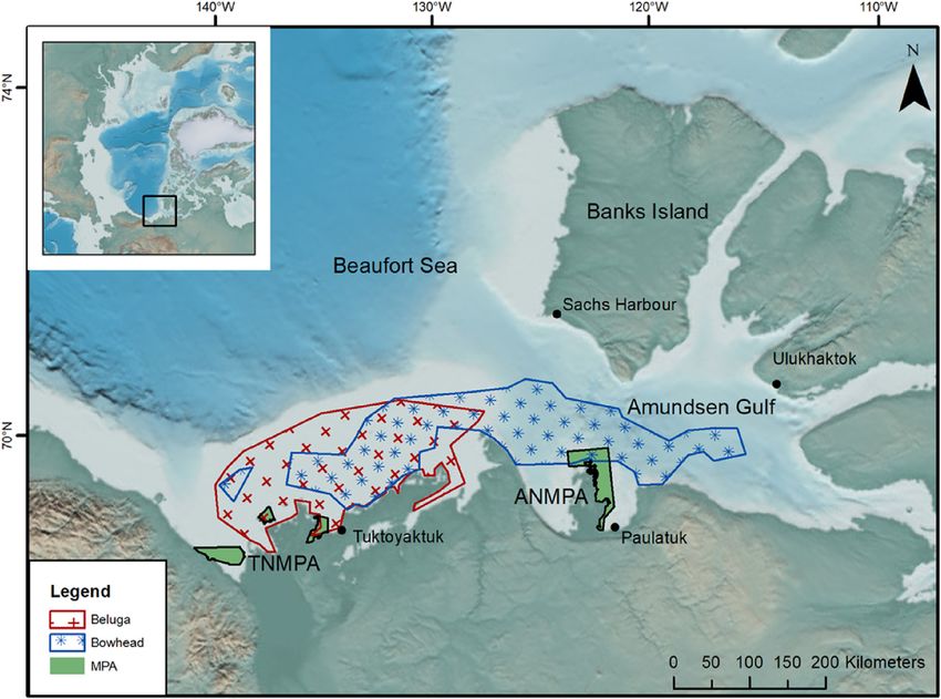
L.H. McWhinnie et al.                                                                                              Ocean and Coastal Management 160 (2018) 1–17

chronic noise emitted from vessels may have wide ranging masking                  wounds consistent with ship strikes on harvested individuals (George
effects on cetaceans (McKenna et al., 2012; Erbe et al., 2016; Dunlop,             et al., 1994; Reeves et al., 2012). Indirect evidence that large vessels
2016). Whales are also at risk of ship strikes, which is recognized by the        will also prove hazardous for bowheads can be derived from studies
International Whaling Commission as a global threat to numerous                   such as those conducted by Moore et al. (2004) on their close relatives,
species of cetaceans because being struck by a vessel may result in               the North Atlantic Right Whale (Eubalaena glacialis). North Atlantic
significant injury or even mortality (Reimer et al., 2016). In addition,           right whales are found in the heavily trafficked waters of eastern North
through increased vessel traffic cetaceans may face a greater risk of               America and their numbers have shown little recovery since their take
being exposed to vessel-generated oil spills or marine discharges such as         by commercial whaling was prohibited in 1935 (Reeves et al., 2012;
oily water, wastewater, ballast water or garbage (Hoekstra et al., 2002,          Kraus et al., 2016). This is in direct contrast to the BCB population of
2003; Huntington et al., 2015).                                                   bowheads and Southern right whales (Eubalaena australis) (Bannister,
                                                                                  2001) that have seen their numbers increase steadily over the past few
1.2. Arctic cetaceans                                                             decades. Thus, there would appear to be sufficient evidence to raise
                                                                                  concern over the future of BCB bowhead whale population, given the
    While climate change has caused dramatic shifts in northern sea ice           predicted increase in Arctic vessel traffic.
regimes, the marine mammals that reside in Arctic waters have now
attained a globally iconic status as they reflect the dangers of global            1.3. Implications for conservation and management of marine mammals
warming (Meek et al., 2011). Arctic marine mammals are a particular
conservation concern for multiple reasons, including their importance                 Marine mammal species in the Arctic, including beluga and bow-
in subsistence culture and economy in northern hunting communities                heads, are top multi-level consumers within these ecosystems and have
and their role within Arctic ecosystem functions (Reeves et al., 2012,            an integral role in sustaining high latitude ecosystems (Meek et al.,
2014). Living resources such as whales have long been managed and                 2011). As such, any increase in vessel traffic has implications, not only
utilized by indigenous communities, with ice cover previously being               for conservation of these species, but also for the human indigenous
used to assist in the protection of some of these ‘stock’ species                 communities that depend on these mammals for fundamental nutri-
(Fernandez et al., 2016). Three species of cetacean are endemic in                tional needs and their heritage and cultural identity (Meek et al., 2011;
Arctic waters: bowheads (Balaena mysticetus), narwhals (Monodon                   Reeves et al., 2012; Fernandez et al., 2016). Historically, marine
monoceros), and belugas (Delphinapterus leucas) (Reeves et al., 2014),            mammal conservation initiatives have typically resulted in permanent
although only two of these species (belugas and bowheads) are found               or semi-permanent spatially-defined coastal regions under the implicit
within our area of interest, the Beaufort Sea.                                    assumption that the target species would continue to aggregate within
    Belugas are the most numerous of Arctic whales: globally there are            their known habitat distribution and utilize important areas within
thought to be at least 150,000 belugas composed of at least 20 sub-               their range such as migratory corridors, calving ground or foraging sites
populations (or ‘stocks’) (Reeves et al., 2014). Despite their overall            (Reimer et al., 2016). However, any increase in underwater noise from
numbers, some sub-polar populations, such as the St. Lawrence stock,              the likes of vessel traffic could result in animals changing migration
are known to be in serious trouble. The St. Lawrence stock is currently           patterns or regional residency, becoming less predictable, and the
listed as Threatened under Canada's Species at Risk Act (DFO, 2012)               abandonment of previously important areas (Findley and Vidal, 2002).
and Endangered by the Committee on the Status of Endangered Wildlife              In addition, as marine mammals also respond to environmental
in Canada (COSEWIC) (COSEWIC, 2014). Despite the application of                   changes, migration patterns, or regional residency can become less
protective measures, this population has shown no sign of recovery.               predictable, thus conventional protection measures (e.g. spatially fixed
This has mostly been attributed to the impact of anthropogenic activ-             regions such as marine reserves) may fail to provide sufficient protec-
ities within their environment and their exposure to environmental                tion (Reimer et al., 2016). In the Arctic, this could reduce the success
contaminants (Gervaise et al., 2012; Mosnier et al., 2015). One of the            rate of local subsistence hunters (Reeves et al., 2012) or force them to
largest stocks spends its summer further north in the Beaufort Sea and is         travel farther (Huntington et al., 2015). Another major criticism of
thought to comprise of almost 40,000 individuals (Reeves et al., 2014).           marine reserves generally, and particularly several of those established
Belugas are known to be sensitive to certain types of noise. For ex-              for marine mammals, is that they represent “paper parks” that provide a
ample, in Arctic regions they have been observed fleeing ice breakers              false sense of conservation achievement (Hooker and Gerber, 2004).
and using alarm vocalization in response to distant ships (Cosens and                 Marine Protected Areas (MPAs) are a common generic term for
Dueck, 1993; Reeves et al., 2014). They have, however, also been                  different types of marine reserves that aim to protect and conserve
shown to become habituated to ‘less-threatening’ vessel noise and are             associated flora and fauna within an area. MPAs and other marine
found in busy waterways such as the St. Lawrence estuary.                         planning tools can be used to mitigate a suite of threats via area based
    Globally, the number of bowheads, comprised of four sub-popula-               management schemes (Wright et al., 2011). Hoyt (2009) suggested that
tions, is thought to number over 18,000 animals (George et al., 2004),            MPAs devised to protect marine mammals would require targeted
with some populations such as those in Bering-Chukchi-Beaufort Seas               management measures that would aim to address marine mammals and
(the BCB population), having recovered to the point where they are                ecosystem threats either as part of the MPA itself or through existing
now listed as a species of Least Concern by IUCN (IUCN, 1996). Two of             laws and regulations. Therefore MPAs could potentially act as a legis-
the four sub-populations, the Okhotsk Sea and the Svalbard-Barents Sea            lative tool for countries to protect whales from the impacts of shipping.
populations, however, have not shown such recovery success and are                MPAs have been effectively used around the world to create sanctuaries
red-listed as Endangered and Critically Endangered, respectively, by              from fishing (Côté et al., 2001), but their use for vessel management is
IUCN. All populations of bowheads are migratory to some degree al-                not well documented. However, a placed-based tool for protecting
though the extent of this movement varies regionally (Reeves et al.,              whales from ships may be one of the few policy measures that a country
2014). Studies have shown bowheads to be relatively sensitive to in-              can implement to physically protect whales from the presence and
dustrial activity, exhibiting avoidance responses to noise sources such           impacts of vessels within their habitats. Furthermore, when an area is
as ships and seismic surveys at low received levels (Richardson et al.,           designated as an MPA, it is set aside for some form of conservation,
1999; McDonald et al., 2012; Blackwell et al., 2013, 2015). Therefore, it         which can prove very restrictive for some activities within the area
is very likely that increased industrialized vessel traffic will increase the       depending on the conservation needs and goals of that MPA. Therefore
risk of harm to bowhead whales (Reeves et al., 2012). Alaskan sub-                careful consideration must be given to the design, size, goals and
sistence hunters have already helped provide evidence of the bowheads             management of MPAs, especially those in remote areas such as the
susceptibility to ship strikes through the documentation of scars and             Arctic where enforcement issues can arise (Nyman, 2016).

                                                                              2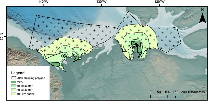
L.H. McWhinnie et al.                                                                                             Ocean and Coastal Management 160 (2018) 1–17

1.4. Regulation and management of vessels for marine mammals                     the North. Furthermore, application of these measures to the Arctic
                                                                                 would seem like a logical and important first step toward ensuring
    In addition to the uncertainty related to the location of cetacean           minimal impacts arise from any increase in vessel traffic in the North
species, data on Arctic shipping has until recently been inadequate for          (Huntington, 2009). Through the application of a lessons learned ap-
environmental assessment purposes. Understanding of the general and              proach, we evaluate each tool or mechanism identified during a review
dose-specific responses of Arctic whales to the new types and levels of           of MPAs currently utilizing vessel management schemes in terms of
disturbance associated with escalating vessel activity is also lacking           suitability for use in the Arctic. We then explore the utility of these
(Reeves et al., 2014). It is also now recognized that further recovery and       management scenarios using automatic identification system (AIS) data
protection of cetacean species requires the implementation of con-               for vessels and GIS analysis for a study site containing recently desig-
servation measures designed to mitigate the risks posed by various               nated MPAs in the eastern Beaufort Sea and Amundsen Gulf. This work
emerging stressors (Chion et al., 2017). While the risks posed from              highlights several issues related to vessel management within an Arctic
vessels have not been a great concern in the past, many now believe              context in an anticipatory and proactive manner. In the final section of
that precautionary measures should be proposed to protect these cul-             this paper, we provide recommendations for future management con-
turally-significant animals from threats that changing Arctic conditions          sideration that aim to both safeguard local populations of Arctic ceta-
may present (Allen, 2014).                                                       ceans and ensure that any future increase of vessel traffic and asso-
    Globally, regulation and management of vessel traffic utilizes rela-           ciated socio-economic development is managed responsibly.
tively few measures to control the location, speed, and behavior of ships
in order to reduce risks to safety and the environment (Huntington               2. Materials and methods
et al., 2015). We will discuss these limited measures extensively over
the course of this paper. Many of these management measures have                 2.1. Review of non-Arctic vessel management schemes within MPAs
already proven successful in reducing vessel-strike risk to Atlantic right
whales through altering the probability of vessel-whale co-occurrence                We began by utilizing the extensive review of MPAs published in
or by reducing the lethality of strikes through vessel speed restrictions        Marine Protected Areas for Whales, Dolphins, and Porpoises: A world
(Reimer et al., 2016). Many have suggested imposing shipping restric-            handbook for cetacean habitat conservation and planning by Hoyt (2011).
tions in advance of a boom in ship traffic may be easier than doing so             Hoyt (2011) reviews and compiles a list of 1076 MPAs that have been
after shipping has increased (Huntington, 2009).                                 designated globally which have in some manner an affiliation with one
                                                                                 or more species of cetacean. We were only interested in MPAs that have
1.5. Arctic vessel management                                                    both an established management plan in place and plans which refer-
                                                                                 enced and attempted to address issues related to vessels within that
    Mobile and stationary Arctic resources, for example marine mam-              MPA. Of the 1076 “cetacean MPAs' that Hoyt reviewed, only 78 of these
mals and mineral deposits, may straddle various political and geo-               were found to meet the criteria laid out for this study. We then re-
graphic boundaries at regional and international scales (Fernandez               viewed these MPAs in further detail and collected information related
et al., 2016). For example, the trans-boundary nature of the bowhead             to the management tools proposed, developed, and employed along
and beluga populations in the Beaufort Sea makes it important that               with the status of their implementation. It became apparent at this stage
communication and strategic planning are pursued on an international             of the exercise that while many management plans listed vessels as a
basis (Reeves et al., 2012). Currently, each Arctic country and in-              potential threat and proposed several strategies for mitigating risk to
digenous community may have sovereign legally binding statutes se-               marine mammals (when it was acknowledged that there was a specific
parately in their own jurisdictions. However, the Arctic region as a             risk to that species), very few have actually employed active manage-
whole is lacking a coherent and binding policy with regard to shipping           ment tools/mechanisms. This reduced the total number of MPAs re-
(the Arctic Council has non-legally binding policy) (Fernandez et al.,           viewed in this study to 33.
2016). One mechanism aims to bridge all Arctic jurisdictions is the                  From the 33 MPAs identified as having ‘active’ vessel management
International Maritime Organization's (IMO's) Polar Code, which is a             schemes, we identified a total of 14 management tools/initiatives (with
mandatory code of conduct which aims to harmonize and upgrade                    some variations such as voluntary/mandatory and permanent/sea-
vessel operating standards within international Arctic waters (Reeves            sonal), many of which appeared in the management schemes of mul-
et al., 2014; IMO, 2017). However, many still feel that the existing             tiple MPAs. In addition, several tools were often employed within a
Arctic governance structure is insufficient and too fragmented to handle           single MPA to manage vessels. For this reason, as well as the scale and
an increase in human activities and while sectoral agreements like the           detailed nature of this assessment, we decided to classify the tools
Polar Code are important, they cannot address the need for integrated            identified into four distinct groups: Spatial, Vessel, Monitoring, and
governance (Fernandez et al., 2016). International management in-                Outreach. Details about each of the tools within these groups, including
struments may prove to be an alternative and good mechanisms for                 information related to their application, examples of MPAs that cur-
implementing or at least preserving conservation options until such a            rently employ them, evidence of successful elements of their deploy-
multi-functional agreement is developed. For example, IMO has desig-             ment, and some of the challenges encountered so far, can be found in
nated 13 large areas as Particularly Sensitive Sea Areas (PSSAs), al-            Tables 1–4.
though none have been designated in the Arctic as yet (Reeves et al.,                At this stage of the analysis, we combined our experience as well as
2014). Designation of any PSSA will still require it to be linked to             knowledge gained from published literature to evaluate each tool
jurisdictional policies and regulations alongside any measures taken by          identified and then assessed the potential suitability of each tool under
industries in order to prevent pollution and impacts from ships (Reeves          deployment in Arctic conditions. We compiled a list of possible chal-
et al., 2014). Therefore the capacity of the Arctic to adapt to change and       lenges and opportunities for each tool and then discussed at length
associated development will likely depend on cooperation between the             which tools, given the evidence gathered, should be most readily con-
various stakeholders that may or may not be formally linked by a                 sidered in the context of managing vessels in the Arctic (Tables 1–4).
current governance institution (Fernandez et al., 2016).
    In this paper, we examine current mechanisms being employed to               2.2. Case study: Amundsen Gulf, Canadian Arctic
manage vessels and mitigate the risks that they pose to cetaceans in
non-Arctic waters. Since there are few examples of vessel management                We use this case study to examine how the different vessel man-
within the Arctic, we draw on conservation measures to address ship-             agement measures described in Tables 1–4 would work in an Arctic
ping effects outside the Arctic, which may have application potential in          scenario. The case study area that we selected was the eastern Beaufort

                                                                             3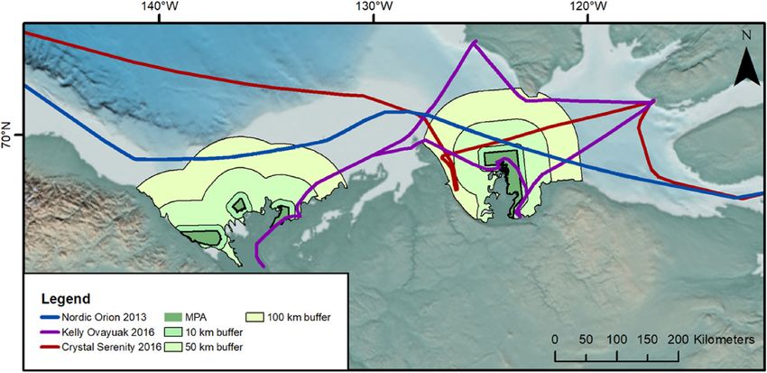
Table 1
Spatial management tools for vessels in use within MPA management schemes.
Tool Evidence: Successful Components Evidence: Issues that have arisen Challenges that may arise in the Arctic Opportunities that could present in the
Arctic
L.H. McWhinnie et al.
Mandatory Exclusion Zone: ∗ Only management tool that offers ∗ Slow, difficult and costly to implement ∗ Insufficient policy/legislation for Arctic MM ∗ Ice cover in many regions precludes
No vessels allowed within designated area. complete vessel protection through and ensure compliance. to mandate such a management tool? vessels entering many areas for at least
Examples of Implementation: Al Hoceima removal of all risk. Robson Bight: As ∗ Highly restrictive often leading to ∗ Issues could arise with monitoring/ part of the year.
National Park; Gulf of Trieste Miramare part of the Critical Habitat for Northern stakeholder opposition. Saguenay–St compliance/ enforcement. *Local peoples ∗ Mandatory zones are potentially easier to
MPA; Great Australian Bight Marine Resident Killer Whales it ensures that Lawrence Marine Park: Entire estuary may require access to the area, therefore a police, if vessels are seen in area that is off
National Park this exclusion zone is legally binding. is important beluga habitat, so blanket ban on vessel traffic is unfeasible. limits then there are no grey areas about
It's also enforced via boat patrols in increased risk in condensed areas, and ∗ Navigational safety issues could also the means by which it was transiting.
peak season (BC Parks, 2017). noise pollution everywhere persists preclude a blanket ban due to changes in ice ∗ No vessel, no risk of impact.
(Gervaise et al., 2012). regime requiring vessels to access an area.
Restricted Access/Permitting System: ∗ Limits the number of vessels to what is ∗ Complex and costly to implement and ∗ Most vessels in the Arctic are transiting and ∗ Implementing a permitting system could
Designated area has a carrying capacity for deemed an acceptable amount for a enforce. need to be in the areas as a means of passing allow data collection on vessels
a certain number of vessels each year. Only given area. ∗ Often unclear who will be responsible through, therefore restricted access is transiting areas with poor AIS coverage.
certain vessels with the appropriate permits ∗ Often implemented on a seasonal for developing, financing, implementing unlikely to be a feasible option. This could be used to keep track of
are allowed in. /temporary basis. Glacier Bay: no and maintaining such a scheme Marine ∗ Seasonal restrictions are also unfeasible as vessel time and movement.
Examples of Implementation: Prince more than 25 vessels per day are Mammal Sanctuary of Silver and MMs and shipping co-occur within the ice- ∗ Daily quotas on permits would potentially
Edward Islands MPA; Northeast Sakhalin permitted within the bay from 1 June Navidad Banks: The licensing system free season, they cannot transit at an allow for better management of vessels in
Whale Wildlife Refuge; to 31 August each year. Violations of could be open to corruption, given that alternative time of year (at the moment), specific bottlenecked areas during ice free
the permitting system can lead to the permits are issued to whale essentially creating a temporal bottleneck. months.
evictions and citations (McKenna et al., watching companies. Proving the ∗ Current permitting schemes exist in the ∗ Permits could act as a means of staggering
2017). violations is also inherently difficult and Arctic and are acknowledged as being quite traffic along sections of busy routes.
costly if taken to court will the fees be complex, another permit could add to this ∗ As other permit schemes already exist
enough to cover such costs? a problem and result in poor there is an existing legal framework that
acknowledgement and ultimately can potentially be adapted/built upon.
4
compliance. ∗ Potential job opportunities, local training
∗ Impractical to restrict 100% of local vessels and further qualifications.
primarily due to the need to hunt
Voluntary Exclusion Zone /Area to be * Potentially the quickest and least costly ∗ Compliance not guaranteed ∗ Possibly difficult to identify an alternative ∗ Compliance could be aided by the
Avoided: Recommended that vessels avoid spatial tool to implement. Roseway Basin: ∗ Incentive schemes to increase route due to ice cover and navigational inclusion of ATBA within pre-existing
a designated area. IMO adopted a voluntary ATBA, within 5 compliance may be costly and it is often safety issues. documents such as the Polar Code and
Examples of Implementation: The Gully months, 71% of vessels complied with unclear who should bear the financial ∗ What incentives could be offered in the other charts used by vessels when
MPA; Doubtful Sound Marine Mammal ATBA and reduced risk to right whales by burden of such initiatives Roseway Arctic? Other examples have used reduced planning journeys in the Arctic.
Sanctuary 82% (Vanderlaan and Taggart, 2009). Basin: 29% of vessels ignored ATBA berthing fees, but this would not be ∗ Insurance providers could mandate that
(Vanderlaan and Taggart, 2009). applicable here. vessels must comply with the coastguard
∗ Pilotage schemes could help, however this shipping route (which would take into
would be costly and difficult to implement account the ATBA).
in remote regions as discussed further in ∗ The natural dynamism of voluntary
Table 2 measures means that they are widely more
accepted and adaptable.
Vessel Re-routing /Transit Separation * Removes vessels from section of route * In many instances re-routing is not an ∗ Difficult to identify an alternative route due ∗ Current shipping corridor was
Scheme): Vessel routes are restricted within that has shown to pose a high risk of option due to navigational safety issues to ice cover and navigational safety issues. designated with no conservation
a designated area. vessel/marine mammal overlap Grand (Silber et al., 2012) ∗ No current examples of IMO changing routes knowledge or objectives, therefore, the
Examples of Implementation: Las Perlas Manan Basin: Amended TSS that avoids Grand Manan Basin: voluntary measures, in the Arctic. rationale to move them in light of new
Archipelago; Channel Islands National right whale conservation area reduced risk so compliance is not 100% (Vanderlaan ∗ Route changes need to be 'championed' and evidence would not be as likely to meet
Marine Sanctuary of vessel strike by 62%; unknown et al., 2008). evidence provided to initiate any move, can opposition on those grounds.
compliance (Vanderlaan et al., 2008). this be provided for a particular species in ∗ Movement of lanes where possible, would
the Arctic. likely be marginal due to physical
∗ The process to implement lane re-routes are restrictions and therefore this would
lengthy and potentially quite costly potentially make compliance more likely.
MM – Marine Mammals.
a
Not from citable literature.
Ocean and Coastal Management 160 (2018) 1–17
Table 2
Vessel based tools in use within MPA management schemes.
Tool Evidence: Successful Components Evidence: Issues that have arisen Challenges that may arise in the Arctic Opportunities that could present in the
Arctic
L.H. McWhinnie et al.
Pilotage: Pilots are required on vessels when ∗ Education of local pilots increases ∗ Pilotage schemes are expensive and ∗ Arctic vessel costs are already high, ∗ Having trained Arctic pilots on vessels
navigating certain areas, or when entering likelihood of voluntary management difficult in terms of logistics. additional pilotage may make them could ensure better vessel compliance
or leaving a Port measures being observed. Saguenay-St. Globally: Pilots are becoming difficult to financially unviable. with spatial and vessel management
Examples of Implementation: Lawrence Marine Park: 72% of piloted recruit and can be costly (Bruno and ∗ Unlikely that pilots could only be placed tools
Saguenay-St. Lawrence Marine Park vessels complied with speed restriction Lützhöft, 2009) on ships for part of a journey due to the ∗ Could increase local jobs if local people
compared to 13% prior to slow down remoteness of anchorage locations were trained as pilots.
(Parrott et al., 2016) ∗ Logistical difficulties placing pilots on
vessels, could be more easily implemented
on cruise ships than other commercial
vessels
∗ Lack of pilots operating in northern
regions that are trained to navigate Arctic
waters
Code of Conduct: Vessel must abide by a given ∗ Setting out clear guidelines for vessels * Long, complex codes of conduct may not be ∗ Polar Code doesn't explicitly state the ∗ As the Polar Code is published, it could
Code of Conduct, including min distances makes it more likely that they will followed or well learned by vessels, or only various issues that relate to MM and be easier to add additional sections
from MM comply with regulations as they know those parts that relate to mariner safety vessels related to MM than creating an
Examples of Implementation: Moray what is expected of them. Moray Firth: Inconsistences in key ∗ An additional Code could prove confusing additional document, saving money
Firth SAC; Cardigan Bay SAC; Marine ∗ Codes of Conduct can be used to inform recommendation across voluntary codes of but additions to the existing code would and time.
Mammal Sanctuary of Sliver and Navidad vessel journey planning Cardigan Bay: conduct. Statutory codes may not be well need to come through IMO. ∗ Training could be ensured on all vessels if
Banks; Pelagos Sanctuary Produce and distribute a code of conduct received by stakeholders and costly to enforce ∗ Compliance would also be difficult to insurance companies mandated that it
http://www.cbmwcwildlife/code-of- (Inman et al., 2016). monitor and because there is little safety was a compulsory part of obtaining their
conduct/ risk for mariners from MM, compliance coverage.
with suggested actions could be low.
5
∗ Difficulty could arise when it comes to its
distribution amongst smaller craft and
local vessels- important as the number of
recreational boats is increasing.
Reporting: Vessel must report its position and * Mandatory positions will allow boats to be ∗ Improper use, location errors from the use ∗ Vessel reporting requires good ∗ Local indigenous communities have
course along a given route, often coupled made aware of whales in close proximity to of GPS along with noncompliance. communication between vessels and land local knowledge of MM and vessels
with MM locations being reported to them ∗ Replication of some information if AIS is based authorities, this is not always locations that would aid the formation
vessels. Roseway Basin: East coast Canada Vessel also being collected. possible in remote Arctic areas, of a sightings network.
Examples of Implementation: Pelagos Traffic Services Zone Regulations. Mandatory Globally: mapping (GPS precision) and ∗ No current network in place to record and ∗ Sighting information can be combined
Sanctuary for Mediterranean Marine reporting when entering and departing the measurement errors (GPS error) introduce report whale locations, and place them in with ship reporting to ensure accuracy.
Mammals; Eastern USA Seasonal area (Vanderlaan et al., 2008) further distance travelled errors (Palmer, relation to vessels. ∗ This would require the efforts of local
Management Areas for Atlantic Right 2008) ∗ Real time vessel reporting and MM communities and may provide some jobs
Whales detections could be costly and ∗ Reporting could be enabled through the
unobtainable due to environmental use of land based receiver networks or
conditions and physical limitations as well satellites in more remote areas that are
as financially unsupported. also used to capture AIS data
Speed Reduction: Vessel must slow to a ∗ Speed reductions have been proven to ∗ If speed restrictions are only voluntary, ∗ Vessels transiting Arctic waters are often ∗ Due to hazards, Arctic vessels are
defined speed significantly reduce cetacean mortality compliance not guaranteed, therefore, going quite slow due to navigational naturally not traveling as fast as they
Examples of Implementation: Las Perlas events through ship strikes. unlikely to reduce the risk that vessels hazards, therefore further speed would be in open ocean, this means
Archipelago Special Coastal Mgmt Zone; ∗ Reducing speed can reduce cavitation and pose to whales reductions could be unfeasible and that the strike risk they pose is already
Sha Chau and Lung Kwu Chau Marine therefore the amount of noise emitted ∗ Sometimes due to navigational safety, additionally not result in a notable change reduced.
Park; St. Lawrence-Saguenay Marine Park into the environment. slowing down is not an option for vessels in risk. ∗ Small changes are more palatable; if
Eastern USA SMAs: seasonal speed reduction traveling in hazardous waters ∗ Speed reductions have proven to reduce vessels have to reduce speed to comply
effectively reduced whale mortality to zero Eastern USA SMAs: compliance was the risk of vessel strikes but the results are with management it would likely only be
whales within the SMA (Silber et al., 2014). originally below 5% but did increase through less conclusive when it comes to reducing by a small amount and may result in a
time. (Silber et al., 2014). noise higher uptake if the measure was
voluntary.
MM – Marine Mammals.
Ocean and Coastal Management 160 (2018) 1–17
L.H. McWhinnie et al.

    Table 3
    Monitoring tools for vessels in use within MPA management schemes.
     Tool                                                 Evidence: Successful Components                 Evidence: Issues that have arisen                 Challenges that may arise in the Arctic          Opportunities that could present in the Arctic

     Acoustic:                                             ∗ Passive, relatively inexpensive system        ∗ Generates a lot of data, which is quite         ∗ Due to physical limitations in the Arctic,     ∗ Vocal MM species are highly suitable for
        Passive acoustic monitoring - ambient                allows non-intrusive continuous data            costly to store and process. There can            it could be difficult to get real time             acoustic surveillance. Currently lack of
        noise and MM presence. Also used to                  collection                                      also be issues with analysis not being            acoustic data analysis established using         shipping/anthropogenic background
        calculate vessel source levels and track MMs.        Cardigan Bay: Allows detection in bad           undertaken in real time. Maintenance of           hydrophones because of seafloor                   noise (regardless of high levels of natural
        Real time acoustic monitoring can send               weather conditions when visual                  the system can be costly and time                 topography/ice cover. The distance from          background noise from moving ice)
        notifications to vessels alerting them of MMs.        observations not possible (Simon et al.,        consuming.                                        shore for a cable array could be                 allows for good detection rates and
        Examples of Implementation: Gerry E.                 2010).                                          Glacier Bay: Low acoustic detection               considerable, therefore, as with all types       recordings.
        Studds Stellwagen Bank National Marine                                                               rates could be due to the location of             of Arctic installation, could prove costly.    ∗ Hydrophone deployment would allow year
        Sanctuary; Grays Reef National Marine                                                                hydrophone (McKenna et al., 2017).              ∗ Deployment and retrieval of devices can          round monitoring (potentially remotely) for
        Sanctuary                                                                                                                                              also prove difficult due to seasonal               long term fluctuations in sound/noise levels
                                                                                                                                                               presence of sea ice.                             to be obtained. Current measurements
                                                                                                                                                                                                                would allow for a baseline to be established
                                                                                                                                                                                                                against future changes, something that is
                                                                                                                                                                                                                lacking in many other datasets.
     Visual: MM Observation: land or vessel                ∗ Allows no intrusive data collection and       ∗ Requires a significant amount of                 ∗ Extreme Arctic weather conditions mean         ∗ Visual observers could provide a source of
         observers that report location of cetaceans to      actively alerts vessels to the presence of      personnel resources. Can only take place          that it could be impossible to collect           work to individuals living in remote
         vessels.                                            MM.                                             during the day.                                   visual observation data year round.              communities.
         Examples of Implementation: Gulf of                 Pelagos Sanctuary: REPCET system for            Pelagos Sanctuary: Relies on vessels in         ∗ The distance from vessels to shore could       ∗ Visual observers on ships provide the best
         Farallones National Marine Sanctuary;               real-time knowledge transfer of marine          the area to report sightings, and other           be considerable making visual detection          chance of reducing strike risk.

6
         Cordell Bank National Marine Sanctuary              mammal sightings. Ship operators are            vessels to respond to sightings.                  probability poor.
                                                             trained to look for cetaceans, adjust           Voluntary system, so some may not               ∗ Visual detections would also require paid
                                                             their behavior on the vessel, and report        participate. Sea state/weather will limit         personnel, therefore proving costly.
                                                             sightings through the REPCET system             the effectiveness of this system. (David         ∗ MMs are only at the surface for short
                                                             (David et al., 2011).                           et al., 2011).                                    periods of time and occur in an
                                                                                                                                                               unpredictable manner making visual
                                                                                                                                                               detection challenging, even on days with
                                                                                                                                                               good visibility.
     Spatial: AIS: used to record and monitor vessel      * Provides continuous coverage of vessel        * System produces vast quantities of data          ∗ Land-based AIS stations are not currently      ∗ Additional data related to vessels can be
         movement within an area                          movement within area.                           and requires expert training to process and          established in most places in the Arctic.        gathered even in remote regions (in the
         Examples of Implementation Agoa                  Stellwagen Bank: monitored vessels              analyse.                                             Satellite AIS would need to be used or           case of satellite AIS). Providing a way to
         (Sanctuary of the French Antilles); The Gully;   traveling through Stellwagen Bank to assess     Agoa (Santuary of the French Antilles):              land based installations put in place,           inform vessel reporting and monitor
         Stellwagen Bank                                  their contribution to noise levels (NOAA,       Slight lag from the time of data collection to       both of which are costly.                        compliance management measures in
                                                          2017a).                                         presentation. There are inherent issues with       ∗ Could be issues with data resolution in          areas where other observation techniques
                                                                                                          AIS data that can lead to inaccuracies, also it      remote areas, an issue that is improving         are not possible.
                                                                                                          does not allow for the capture of non AIS            with increased numbers of satellites and       ∗ Some satellite AIS providers can also use
                                                                                                          vessels. a                                           time. Data storage and processing can be         AIS to provide real-time notifications to
                                                                                                                                                               costly but could lead towards real time          ships/land based receivers.
                                                                                                                                                               management in areas where land based
                                                                                                                                                               systems are in place.

    MM – Marine Mammals.
     a
       Not from citable literature.
                                                                                                                                                                                                                                                               Ocean and Coastal Management 160 (2018) 1–17
Table 4
Outreach tools for vessels in use within MPA management schemes.
L.H. McWhinnie et al.
Tool Evidence: Successful Components Evidence: Issues that have arisen Challenges that may arise in the Arctic Opportunities that could present in the
Arctic
Ship: Training ∗ Production of materials that are distributed ∗ Training is voluntary so not always ∗ Vessels already receive training related to ∗ Documents such as the Polar Code could
/information provided to pilots or at no costs to mariners. adhered to and only excluded Arctic navigation, therefore additional make such ship education schemes
captains related to MM and related Turneffe Atoll: Produced a document related to unregulated boats within the boundaries training may not be deemed as important. mandatory for all personnel navigating
impacts of vessels and how to avoid or responsible travel within the MPA. Most of the of the reserve. ∗ Due to remoteness, any training provided Arctic waters.
mitigate these impacts. management is targeted at fisheries specifically Marine Mammal Sanctuary of Silver and would be delivered to vessels before ∗ Length of time of Arctic vessel voyages
Examples of Implementation: Gerry E. however, for vessels they aim to increase Navidad Banks: Outside the MPA permit leaving non-Arctic ports and therefore gives extra time for ship personnel to read
Studds Stellwagen Bank National Marine awareness by engaging boat captains. http:// site unregulated marine mammal tourist may be forgotten by the time they enter material if it is provided onboard ships,
Sanctuary www.responsibletraveldocs/Turneffe%20Atoll boats are in operation. In response to Arctic waters. which would reduce costs.
%20Full%20Report.pdf instances of harassment in areas outside the ∗ Vessels may be preoccupied by
MPA, the government have issued a guide to navigational challenges and less inclined
good practices for the conservation of MM to observe MM training examples.
and a training program. Adherence to these ∗ It is also difficult to monitor the success of
guidelines is not mandatory. such schemes.
∗ Many vessels will be foreign and crews
may not have an appreciation or strong
attachment to the environment or the
need to protect it through self-education.
∗ Due to data limitations, it is difficult to
provide vessels with accurate distribution
maps for all MM species throughout the
full extent of their range.
7
Industry/Stakeholders: Information West Coast USA Sanctuaries: Listserv sends *Voluntary so industry would need to be on ∗ Industry/stakeholder representatives are * At the moment there are less industries and
provided across industry related to reminders out to shipping industry with board. rarely based in the Arctic themselves and stakeholders in the Arctic than would
vessels and MM. Information distributed reminders of seasonal whale presence. Also have in addition many shipping businesses are normally have to be included in other coastal
all stakeholders involved. shipping industry meetings about strike risk multinational. areas.
Examples of Implementation: (NOAA, 2017b). ∗ How this should be approached and who
West Coast USA Sanctuaries would lead and cover such an expense is
unclear, as is how to monitor feedback of
this outreach and relate it to actual
changes in vessel behavior.
General Public: Information delivered to ∗ Dedicated personnel for outreach and ∗ Lack of promotional material or ∗ Remote communities are often spread out ∗ Indigenous communities are often
the general public through outreach and engagement work. ineffective material need to be assessed/ over considerable distances making them involved with managing local areas and
engagement activities/events informing West Coast U.S.A. MPAs: good information altered. costly to target. MPA therefore making them aware of
them about MM and vessels. readily available on NOAA websites, and also Shoal Islands Marine Park: Upon ∗ The public often have little to do with the vessel related issues has an important
Examples of Implementation: have public outreach programs for children and reassessment 2 recommendations were shipping industry, however, are conservational value.
Robson Bight / Michael Bigg Ecological courses for adults. E.g: “See a spout, watch out!” made; More signage provided at additional responsible for smaller watercraft, and ∗ Many communities also have a vested
Reserve; Hawaiian Islands Humpback campaign: access points to the marine park and that therefore there is still a value in spreading interest in maintaining marine mammal
Whale National Marine Sanctuary. https://www.greateratlantic.fisheries.noaa.gov/ research relevant to management by awareness. stocks due to them being a subsistence
protected/mmp/viewing/spout/index.html volunteers, educational institutions and ∗ Arctic communities have to use vessels for food source in several areas.
government agencies be encouraged/ local travel and subsistence so this is an
supported. http://www.conservation.wa. activity that will not be modifiable,
gov.au/media/22523/4.3.13%20shoalwater especially if it results in increased costs.
%20islands%20marine%20park ∗ Difficult to assess effectiveness.
%20management%202007-
2017%20periodic%20assessment
%20report.pdf
MM – Marine Mammals.
Ocean and Coastal Management 160 (2018) 1–17L.H. McWhinnie et al. Ocean and Coastal Management 160 (2018) 1–17
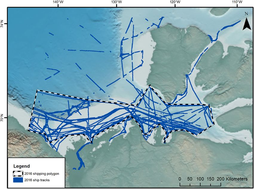
Fig. 1. The eastern Beaufort Sea and Amundsen Gulf study area showing important areas for cetaceans (bowhead and beluga whales) and the Tarium Niryutait MPA
(TNMPA) and Anguniaqvia Niqiqyuam MPA (ANMPA). Areas for cetaceans are representations of the 50% utility distributions calculated by Citta et al. (2015)
(bowhead whales) and Hauser et al., 2014 (beluga whales). Base map provided by NOAA Environmental Satellite Data and Information Service.
Sea and Amundsen Gulf of the western Canadian Arctic (henceforth also include a statement about designated routes, as the community of
referred to as “the study area”; Fig. 1), which we chose based on our Paulatuk relies on shipping for much of their supplies.
familiarity with this site, because it is an important area for both beluga During our review of MPAs (outlined in section 2.1.), we found two
and bowhead whales, and because it already has two MPAs established ‘Spatial’ tools, voluntary avoidance and slow down areas, which provi-
(Tarium Niryutait MPA (TNMPA) and Anguniaqvia Niqiqyuam MPA sionally look to have a relatively high suitability for Arctic application,
(ANMPA)). Another key reason for selecting this area is due to its and we examined these tools using geospatial analysis within our study
proximity to the western entrance of the Northwest Passage, anticipated area. We used satellite AIS data on vessel traffic moving within the
to be a crucial area for managing ship traffic in the future as the route eastern Beaufort Sea and Amundsen Gulf between 2012 and 2016,
becomes more ice-free and utilized as a passage for traffic traveling which was provided by exactEarth Ltd. through the Marine Environ-
between the Atlantic and Pacific Oceans. mental Observation Prediction and Response Network National Centre
The TNMPA, located near the community of Tuktoyaktuk, was de- of Excellence (MEOPAR NCE) sponsored NEMES (Noise Exposure to the
signated in 2010 specifically for beluga whales. The area protects im- Marine Environment from Ships) project. For each year between 2012
portant foraging and congregation areas, especially for mothers and and 2016, we examined vessel tracks throughout the study area. We
calves (see beluga whale core use area on Fig. 1). The ANMPA, located then traced a polygon around the outside of the majority of the vessel
at Darnley Bay near the community of Paulatuk, was designated in tracks to delineate the areas generally used by vessels (Fig. 2), which we
2016 for a wide range of species, including Arctic char, cod, sea birds, refer to as the vessel use area. We excluded tracks from the Canadian
beluga whales, ringed and bearded seals, and polar bears. The ANMPA Coast Guard Ship, CCGS Amundsen, that were northwest of Sachs
also overlaps with important core use areas for bowhead whales (see Harbour because these tracks were related to research activities and do
bowhead whale core use area on Fig. 1). The TNMPA currently has a not represent normal shipping activity (i.e. community supply vessels,
management plan that includes a small section on shipping (p. 25): typical ice-breaking activity, and tourist vessels) within the region. We
compared vessel use areas between years, and use 2016 as a re-
“Bathymetry of the seafloor limits shipping activities to corridors
presentative year because it encompasses vessel use areas from all other
that run through Zone 1(a) areas, so avoidance of these areas is not
years. This vessel data was then used to consider several shipping im-
possible. With regard to shipping activity in Zone 1(a) areas, the
pacts including vessel strike and acoustic disturbance that may be ex-
BSBMP states: “All shipping activities (including dredging) should
perienced by cetaceans that regularly utilize the study area during the
be confined to designated shipping routes and areas. Passage
corresponding time period.
through or close to Zone 1a outside of designated routes, even if it's
The boundary of the TNMPA currently delineates an area of ap-
the shortest route, should be avoided from break-up to 15 August”
proximately 1751 km2, and the ANMPA an area of 2361 km2. It is well
(FJMC, 2001, p. 14)”.
known that vessel noise, due to its acoustic properties, is able to travel
The ANMPA does not yet have a management plan, but it will likely considerable distances and although a vessel may be operating outside
8L.H. McWhinnie et al. Ocean and Coastal Management 160 (2018) 1–17
Fig. 2. Vessel tracks within the eastern Beaufort Sea and Amundsen Gulf in 2016 and the derived Vessel Use Area (VUA) for vessels during 2012–2016. Base map
provided by NOAA Environmental Satellite Data and Information Service.
Fig. 3. Tarium Niryutait MPA (TNMPA) and Anguniaqvia Niqiqyuam MPA (ANMPA) designations and additional 10, 50 and 100 km management zones in relation to
the 2012–2016 VUA. Base map provided by NOAA Environmental Satellite Data and Information Service.
the boundaries of the MPA, noise emitted from the vessel will likely be management tools beyond current boundaries in order to meet the
present within the MPA itself (Halliday et al., 2017). For example, management goals set for a designated area. There have already been
vessels traveling through quiet Arctic waters near these MPAs have several management tools developed in both terrestrial and marine
been heard from over 130 km away (Halliday et al., 2017). Therefore, planning (Lynch and Corbett, 1990; Silva and Williams, 2001; Day,
in order for a management tool to effectively mitigate noise within the 2002) that utilize ‘buffer zones’ around designated areas in order to
MPA boundaries, it may be necessary to extend the area for any meet goals that have been set in order to deal with pervasive threats. In
9L.H. McWhinnie et al. Ocean and Coastal Management 160 (2018) 1–17
this exercise, we explored three different sizes of buffer zones: 10, 50 in each MPA and in the three buffers around each MPA, specifically
and 100 km (see Fig. 3). The 10 km buffer zone was added based on examining how many vessels would be affected in each year between
noise reduction recommendations for the Gully MPA on the east coast 2012 and 2016. We also examined the impact on maximum vessel
of Canada with the aim of protecting marine mammals from the effects speed for a voluntary slow down application in each of the buffer areas
of noise from a variety of sources (Agardy et al., 2011). A 50 km zone derived for the study area MPAs. We specifically focused on the number
provides sufficient distance from noise sources, such as most ships, that of vessels that would be affected by 15, 10, and 5 knot speed restric-
the received levels would no longer be likely to cause behavioural tions, if they were traveling their maximum speed, using data from each
disturbances for marine mammals (based on NOAA criteria; Southall year between 2012 and 2016.
et al., 2009) although they may still be audible (Halliday et al., 2017). A Finally, we examined vessel routes for two vessels during 2016, the
100 km zone is large enough to remove most (if not all) influence of Kelly Ovayuak and the Crystal Serenity, and one vessel during 2013, the
vessel noise on an area (Hoyt, 2011). Buffer zones, along with most Nordic Orion, to explore, in further detail, the implication of applying a
other vessel management measures, at present would only need to be vessel slowdown management scheme within the different buffer areas
seasonal given that vessels currently only travel in this region between around each of the MPAs. Crystal Serenity is a tourist cruise ship
July and October when it is ice-free. However, the ice-free season has (length > 100 m), Kelly Ovayuak is a tug boat (length < 50 m), and the
been extending in recent history and vessel traffic is utilizing this is Nordic Orion is a bulk carrier (length > 200 m), therefore it was ex-
prolonged period of open water (Pizzolato et al., 2014). Any seasonal pected that each vessel would exhibit different transit behavior and
measure implemented would therefore have to be adaptive in order to undertake different routes through the study area. Tug boats, like Kelly
account for variation in duration of the ice-free season. Ovayuak, represent typical current traffic in the region because these
Using the vessel use area previously derived from the AIS vessel boats act as community supply vessels, and have been active in the
track data logged between 2012 and 2016, we also assessed the number region for many years. Tourist vessels, like Crystal Serenity, are be-
of vessels likely to be impacted by any associated management within coming more common in this area, with Crystal Serenity being the first
the extended areas for each of the buffer sizes (see Table 6). tourist vessel to transit the Northwest Passage. Freighters, like Nordic
Orion, are relatively uncommon in the region, but are expected to in-
crease in the future as the Northwest Passage becomes a more viable
2.3. Application of management measures
route connecting the Pacific to the Atlantic. Nordic Orion was also the
first bulk carrier to fully transit the Northwest Passage.
We explored the effect of voluntary avoidance measures on vessels
Table 6
Vessel speeds and the amount of change given the implementation of a speed restriction in different buffer zones.
MPA Buffer Size Year Total no. of No. of vessels with max No. of vessels with max No. of vessels with max % Vessels effected by
(km) vessels speed > 15knots speed > 10knots speed > 5knots 10knot speed restriction
TNMPA 0 2012 0 0 0 0 NA
2013 0 0 0 0 NA
2014 0 0 0 0 NA
2015 0 0 0 0 NA
2016 0 0 0 0 NA
10 2012 4 0 2 4 50
2013 6 0 3 6 50
2014 7 0 4 7 57.1
2015 5 0 5 5 100
2016 6 0 6 6 100
50 2012 11 4 9 11 81.8
2013 15 5 12 15 80
2014 9 3 9 9 100
2015 10 6 10 10 100
2016 13 5 10 13 76.9
100 2012 17 7 15 16 88.2
2013 21 12 20 21 95.2
2014 13 9 13 13 100
2015 19 12 19 19 100
2015 17 10 15 17 88.2
ANMPA … 0 2012 8 4 7 8 87.5
2013 11 4 9 11 81.8
2014 8 3 6 8 75
2015 10 5 9 10 90
2016 8 2 6 8 75
10 2012 11 4 10 11 90.9
2013 14 6 11 14 78.6
2014 9 4 8 9 88.9
2015 11 6 10 11 90.9
2016 12 4 9 12 75
50 2012 15 4 14 15 93.3
2013 17 9 15 17 88.2
2014 13 9 13 13 100
2015 18 10 18 18 100
2016 17 9 9 17 94.1
100 2012 15 5 13 15 86.7
2013 17 12 16 17 94.1
2014 14 10 13 14 92.9
2015 18 14 17 18 94.4
2016 17 13 16 17 94.1
10L.H. McWhinnie et al. Ocean and Coastal Management 160 (2018) 1–17
Using three different types of vessels in this manner allowed us to 3.2. Vessel tools
consider the implications that these management tools would have for
different types of vessels. For each vessel, we calculated the distance A total of four tools were identified as being predominantly ‘vessel-
each vessel travelled within each MPA and in each of its associated based’, although most also had strong spatial components (see Table 2).
buffer areas. We used both the maximum speed recorded and mean Speed reduction as a tool sparked recent discussions as to its effec-
speed travelled in the study region, which we calculated using the AIS tiveness for reducing vessel noise (McWhinnie et al., 2017), however, it
data (Crystal Serenity: max speed = 21.8 knots, mean speed = 11.2 is widely accepted to be a viable tool for reducing ship strike risk in
knots; Kelly Ovayuak: max speed = 11.8 knots, mean speed = 6.9 certain cetacean species (Vanderlaan and Taggart, 2007; Lagueux et al.,
knots; Nordic Orion: max speed = 20.6 knots, mean speed = 12.1 2011). Therefore in addition to the points highlighted in this table,
knots; estimated via satellite AIS data) and the total distance travelled discussions around this and many other tools emphasized that it will
to calculate the minimum total time spent traveling (based on max also be important to consider the nature of the primary vessel threat as
speed) and the likely time spent traveling (based on mean speed). From well as the target species.
this information, we calculated approximate values for the extra time The authors also recognized that in the case of adopting a code of
that would be incurred given the observance of a slowdown within the conduct in the Arctic, this would in no way be comparable to the Polar
buffered areas and in the MPAs, and also the impact of an exclusion Code. This said, having an established ‘universal’ Arctic code such as
zone within MPAs for vessels that travelled through either of these this IMO document that for safety reasons ensures all Arctic mariners
areas. are familiar with it, could present a unique opportunity not present in
non-Arctic waters. Inclusion of a ‘code of conduct’ for vessels when in
the presence of marine mammals within existing frameworks (e.g. Polar
3. Results Code) may enable wider dissemination. The Polar Code currently tells
vessels to avoid marine mammal congregation areas, but does not tell
We identified 14 vessel management tools during the MPA review, vessels where these are or how to avoid them. This information is a
which we separated into four different groups: Spatial, Vessel, crucial next step.
Monitoring, and Outreach. All bar the four spatial tools could prevail
beyond the MPAs themselves, especially those associated with out- 3.3. Monitoring tools
reach. We evaluated each group of tools, including evidence of success
or failure, and the efficacy of using each tool in the Arctic (see Tables The three tools that we classified as monitoring tools (Table 3) are
1–4). arguably not management tools at all but rather a means of measuring
the success of a management measure being deployed. However, given
that many of these schemes utilize a suite of tools and that monitoring is
3.1. Spatial tools implicit in gauging their success, the addition of a management tool
group within this analysis was deemed necessary.
Four of the tools which we identified were predominantly spatial in
nature (Table 1): mandatory exclusion zones, restricted access/per- 3.4. Outreach tools
mitting systems, voluntary exclusion zones/area to be avoided, and
vessel re-routing/transit separation schemes. Note that both areas to be Many of the examples of management schemes that were explored
avoided and transit separation schemes are typically designated by the utilized more than one outreach tool working in conjunction with the
IMO once they have support from a member country. Both of these tools other spatial and/or vessel tools. The three broad categories into which
have been used in non-Arctic MPAs with some success (Table 1). What we have grouped these tools into (Table 4) reflect the target recipients
became apparent from looking at several case studies was that many of rather than the tools themselves. Often, outreach schemes in the ex-
these tools were only implemented following the establishment of amples included more than one of these groups in their strategies.
protection for recognized endangered species or populations, proof of
ecological uniqueness/significance, or due to recognized impacts from 3.5. Case study: application of management tools
vessels. Therefore, for any of them to be readily applied within the
Arctic, one of these factors would likely need to act as a driver also in After compiling the data gathered from the MPA review within
this region as well. If such evidence does not exist, this may suggest that Tables 1–4, we evaluated the viability of each tool for use in the Arctic.
the likelihood of a spatial tool being successfully applied is decreased. We identified two tools, voluntary exclusion zones and voluntary speed
Spatially delineating areas could also prove challenging in the Arctic reduction zones, as the tools that could most readily be deployed in the
due to the rapidly changing environment and ice formations, and immediate future. We explored the use of these two different man-
adaptability could be a necessity if a spatially explicit tool is to be in- agement tools spatially within the study area.
troduced. We used vessel track data from 2012 to 2016 to derive a vessel use
Many additional points were discussed among the authors in rela- area (Fig. 2). The area predominantly used by vessels over all five years
tion to Arctic deployment of these tools, such as lack of deep water is delineated within Fig. 2, while the vessel tracks shown are from a
harbours and vessel bearing capacities of many areas not being well representative year of vessels transiting the area in 2016. A total of 67
established. These and many more important points were not included unique vessels travelled within the study area between 2012 and 2016
in this table; only the challenges and opportunities perceived to be key (some of these vessels travelled within the study area over multiple
to Arctic vessel management in general can be found in columns three years). Of these vessels, 18% were government/research vessels (in-
and four of Table 1 below. We also noted that, in our experience, any cluding coast guard ice breakers), 18% were tug boats, 15% were
voluntary management tools usually found greater uptake if they uti- passenger vessels, 13.5% were recreational vessels, 10.5% were con-
lized local people and engaged with those involved from the start of the tainer ships, 6% were naval vessels, 4.5% were tankers, and the re-
process. This may prove more difficult for all Arctic tools due to the maining two vessels were a dredger and a fishing vessel.
remoteness. We also all agreed that voluntary measures would likely The three buffers applied (10, 50 and 100 km) around each MPA,
prove to be important for the successful more immediate implementa- were specifically delineated with the goal of reducing the levels of as-
tion of any tool given that enforcement or monitoring would also be sociated vessel noise within the MPAs (See section 2.2 for further de-
difficult at such latitudes. tails). With the application of each of the different buffers, the areas
covered by the MPA increase to between 4486 and 34,340 km2 for the
11You can also read