VESSEL TRAFFIC SERVICE HOUSTON/GALVESTON - USER'S MANUAL Revised February 2015
←
→
Page content transcription
If your browser does not render page correctly, please read the page content below

VESSEL TRAFFIC SERVICE
 HOUSTON/GALVESTON

    USER'S MANUAL
       Revised February 2015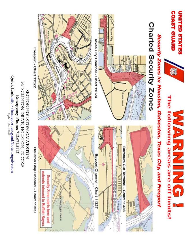
USER GROUPS

VMRS Users (Full Participation):
   These vessels must monitor the designated VTS VHF-FM frequency, make
   reports to the VTS, and comply with general VTS operating rules:

   - A power-driven vessel of 40 meters (approximately 131 feet) or more in
      length, while navigating;

   - A commercial vessel of 8 meters (approximately 26 feet) or more in
      length engaged in towing, while navigating;

   - A vessel certificated to carry 50 or more passengers for hire, when
      engaged in trade.

VTS Users (Passive Participation):

   These vessels must monitor the designated VTS VHF-FM frequency for the
   area in which they are operating, respond if hailed, must communicate in
   the English language, and comply with general VTS operating rules:
   - A power-driven vessel of 20 meters (approximately 66 feet) or more in
      length;
   - A vessel of 100 gross tons or more carrying 1 or more passengers for
     hire;
   - A towing vessel (light boat) of 26 feet or more in length while navigating;
   - A dredge or floating plant.

Non-VMRS Users / Non-VTS Users:

If you do not fall into either of the categories above, you are not required to
participate with the VTS. Your vessel does, however, remain subject to:

   - VTS Measures (direction given by the VTS);

   - All other practices of safe navigation and prudent seamanship.

                                       2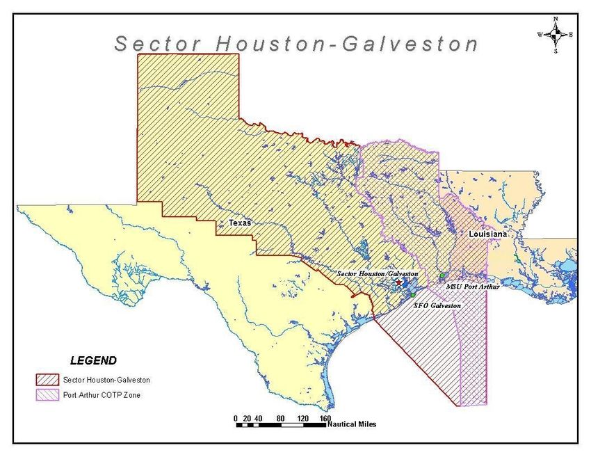
Table of Contents
Introduction ..............................................................................................................5
HOW TO CONTACT US .......................................................................................6
Section I Quick Reference Guide ...........................................................................7
   INDIVIDUAL RESPONSIBILITIES ......................................................................................... 7
   - Who must participate in the VTS? ........................................................................................... 7
   - I am a VMRS User. How do I report? ...................................................................................... 7
   - I am a VMRS User. What must I report? ................................................................................. 8
          SAILING PLAN: ................................................................................................................ 8
          POSITION REPORT:....................................................................................................... 8
              FINAL REPORT ........................................................................................................... 9
          OTHER REPORTS: ......................................................................................................... 9
   - I am a VTS User. What must I do?........................................................................................... 9
   - Can the VTS direct the movement of my vessel? .................................................................. 10
   - May I Depart from the VTS Procedures for Convenience? ................................................... 10
   - Where May I Push in to the Bank with my Tow? .................................................................. 10
   - Use of the Bolivar Roads Alternate Inbound Route ............................................................... 10
   - Are Towing Lights required when I leave the GIWW? ......................................................... 11
Section II Extracts of Federal Regulations ..........................................................13
   33 CFR Part 161Vessel Traffic Management ........................................................................... 15
   33 CFR 164.46 Automatic Identification System (AIS). .......................................................... 25
   33 CFR 110.197 Galveston Harbor, Bolivar Roads Channel, Texas........................................ 29
   33 CFR 165.804 Snake Island, Texas City, Texas; mooring and fleeting of vessels-safety zone
   ................................................................................................................................................... 30
   33 CFR 165.813 Security Zones; Ports of Houston and Galveston, TX. ................................. 31
   33 CFR 165.814 Security Zones; Captain of the Port Houston-Galveston Zone ..................... 32
Section III Useful Things to Know .......................................................................35
   Distress Reports ........................................................................................................................ 36
   Aids to Navigation and AtoN Knockdowns ............................................................................. 36
   Hazardous Operating Conditions .............................................................................................. 36

                                                                           3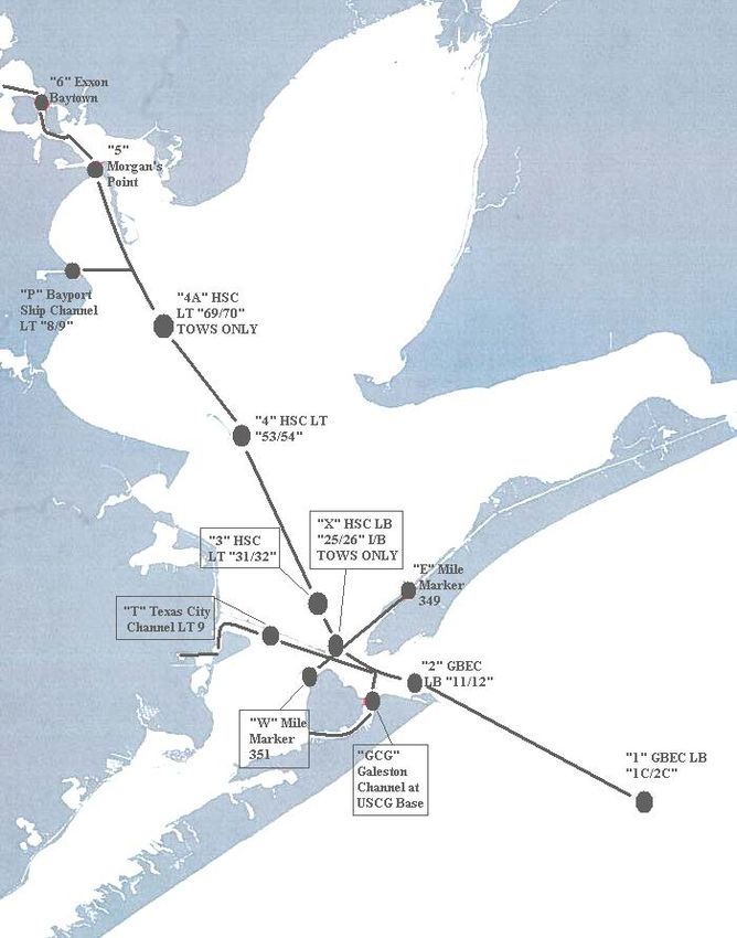
Channel Obstructions ................................................................................................................ 37
  Dredges and Floating Plants ..................................................................................................... 37
  Ferry Operations ....................................................................................................................... 38
  Vessel Moorings that Impact Waterway Navigation ................................................................ 38
  Security Zones .......................................................................................................................... 38
  Safety Zones.............................................................................................................................. 38
  Oversized Tows ........................................................................................................................ 38
  Government Moorings .............................................................................................................. 39
  Towing on a Hawser Above Morgans Point ............................................................................. 39
  VTS Houston/Galveston Chartlets ............................................................................................ 39
USER MANUAL APPENDICES .........................................................................41
  Appendix A Inshore Anchorage Restrictions ........................................................................... 43
  Appendix B Mooring Restrictions ............................................................................................ 45
  Appendix C Marine Casualty Reporting -Inland ...................................................................... 47
  Appendix D AtoN Knockdown Reporting ............................................................................... 53
  Appendix E Security Zones ...................................................................................................... 55
  Appendix F Railway Bridge Alternate Route ........................................................................... 57
  Appendix G Oversize Tows ...................................................................................................... 59
  Appendix H VTSA Distance Tables ......................................................................................... 61
  Appendix I Reporting Points .................................................................................................... 63
  Appendix J Working Frequencies ............................................................................................. 65
  Appendix K Useful Internet Links ............................................................................................ 67

                                                                     4
Introduction
  Vessel Traffic Service Houston/Galveston’s mission is to facilitate safe, efficient
  waterborne commerce. Specifically, VTS Houston/Galveston exists to prevent
  groundings, allisions, and collisions by sharing information and implementing
  appropriate traffic management measures.
__________________________________________________

This manual is intended to provide you, the mariner, with the information necessary for your
participation in the Houston-Galveston Vessel Traffic Service. The purpose is to clarify required
information and to make it readily available. It is not our intent here to modify or conflict with
existing regulations. Any apparent conflict should be resolved in favor of the regulations. We
have included excerpts from other applicable regulations, but please note that this manual does
not pretend to include all of the regulations required and appropriate to your operations.

We have included supplementary boxed text which is not part of the regulations but is meant to
clarify and/or explain the regulatory text.

Carrying this manual satisfies the requirement of 33 CFR 161.4 “Requirement to carry the rules.”

ABOUT VTS HOUSTON-GALVESTON
Coast Guard Vessel Traffic Service (VTS) Houston/Galveston is a mandatory vessel movement
reporting system established under the authority of the Ports and Waterways Safety Act of 1972
(PWSA). VTS Houston/Galveston was commissioned in 1975 in response to concerns for
maritime safety along the Houston Ship Channel, adjacent harbors, and connecting waterways.
The purpose of the Vessel Traffic Service is to increase the good order and predictability of local
ship channels, adjacent harbors, and connecting waterways by collecting, analyzing, and
disseminating information contributing to safe navigation. The goal is to reduce the potential for
groundings, allisions, and collisions; and to protect people, property, and waterways in the
Vessel Traffic Service Area (VTSA) from environmental harm, injury, or damage resulting from
marine mishaps. VTS accomplishes this mission through the use of various surveillance
equipment systems, the monitoring of bridge-to-bridge communications, the Vessel Movement
Reporting System (VMRS), the proactive analysis of channel/traffic conditions, and the
exchange of information with mariners.

MARINERS ARE CAUTIONED THAT REPORTS PROVIDED BY THE VTC ARE
BASED LARGELY UPON INFORMATION RECEIVED FROM VTS PARTICIPANTS.
VTS REPORTS CAN BE NO MORE ACCURATE THAN THE INFORMATION
PROVIDED.
This is your manual. The Coast Guard welcomes any suggestions that may improve it or the
services provided by VTS Houston/Galveston. Suggestions may be forwarded to the Director,
VTS Houston/Galveston.

We also encourage you to visit us at the Vessel Traffic Center. Reservations are requested for
large groups. Tours may be arranged by contacting the Director or the VTS Operations Officer.

                                                5
HOW TO CONTACT US
Coast Guard Sector Houston-Galveston
Vessel Traffic Service Houston/Galveston
13411 Hillard Street
Houston, TX 77034
VTS Houston/Galveston
VTS Director: Office 281- 464-4826 Cell 713-818-4405
Steven.W.Nerheim@uscg.mil
VTS Operations Officer Office 281- 464-4829
VTS Watch Supervisor: (24/7) 281- 464-4837
Website: http://www.uscg.mil/vtshouston
VHF FM CH 05A/11/12
Local Coast Guard Contacts
Sector Houston-Galveston 281- 464-4851 VHF-FM CH 16
Sector Houston-Galveston Situation Controller 281-464-4855
Oversized Tow Permits
National Response Center 800-424-8802 (24hrs)
Eighth Coast Guard District
Commander
Eighth Coast Guard District
Hale Boggs Federal Building
500 Poydras Street
New Orleans, LA 70130-3396
6Section I Quick Reference Guide
- In All Cases and For All Vessels
INDIVIDUAL RESPONSIBILITIES
The safe operation of a vessel remains the responsibility of the vessel's master. If, in a specific circumstance, a VTS
User is unable to safely comply with a measure or direction issued by the VTS, the VTS User may deviate only to
the extent necessary to avoid endangering persons, property, or the environment. The deviation shall be reported to
the VTS as soon as is practicable. This applies to VMRS Users and VTS Users alike.
- Who must participate in the VTS?
If you are:
a. A power-driven vessel of 40 meters (approximately 131 feet) or more in length, while navigating;
b. A commercial vessel of 8 meters (approximately 26 feet) or more in length engaged in towing, while
navigating; or
c. A vessel certificated to carry 50 or more passengers for hire, when engaged in trade,
you are a VMRS User (full participation), all parts of the VTS regulations apply to you, and you must
participate.
If you are:
a. A power-driven vessel of 20 meters (approximately 66 feet) or more in length;
b. A vessel of 100 gross tons or more carrying 1 or more passengers for hire;
c. A towing vessel (light boat) of 26 feet or more in length while navigating, or
c. A dredge or floating plant,
you are a VTS User (passive participation) and must monitor the designated VTS VHF-FM frequency for
the area in which you are operating, respond if hailed, and comply with general VTS operating rules.
The difference between VMRS Users and VTS Users is that VTS Users are not required to make the reports
required of VMRS Users under 33CFR 161.19-22. This difference does not, of course, prevent VTS Users from
making reports in the interest of safe navigation and waterway security.
If you do not fall into either of the categories above, you are not required to participate with the VTS, but your
vessel remains subject to VTS Measures (direction given by the VTS) and to all other practices of safe navigation
and prudent seamanship.
- I am a VMRS User. How do I report?
The Vessel Traffic Center (VTC) call sign is "HOUSTON TRAFFIC." VTS Houston/Galveston requires
masters/towboat pilots to use the vessel's official name when calling the VTC. Houston pilots/Galveston-Texas
City pilots may use their individual identification number in addition to the vessel's name. All communications
must be in the English language.
DESIGNATED FREQUENCIES
-VHF-FM Channel 05A (156.250 MHz) is used for Initial Check-In with Houston Traffic. All vessels checking
in to the system must first contact Houston Traffic on this frequency to submit a Sailing Plan, prior to
shifting to the appropriate working frequency (Channel 11/12).
- VHF-FM Channel 11 (156.550 MHz) for communicating with Houston Traffic inbound at Baytown Bend Light
111, or operating above that location in either direction.
7- VHF-FM Channel 12 (156.600 MHz) for communicating with Houston Traffic outbound at Baytown Bend Light
111 or operating below that location in either direction.
REPORTING WAIVER
On July 2, 1996, The Eighth Coast Guard District Commander waived the 33 CFR 161.23 requirement
concerning ferry Sailing Plans. VTS will report how many ferries are in operation.
- I am a VMRS User. What must I report?
SAILING PLAN:
VMRS Users must report the following information via VHF-FM Channel 5A prior to entering the VTSA or getting
underway (preferably in this order):
- Vessel Name;
- From (Origination Point);
- To (Destination);
- Tow Configuration (How many and # of loaded/unloaded barges/if any CDC barges, if so, CDC barge name);
- Vessel's Dimensions (Length x beam x draft);
- Bunker Info (If Applicable);
(1) Ship;
(2) Time required;
(3) Phone number;
- Next Port of Call (For all outbound piloted vessels);
- Other.
REPORTING WAIVER
On August 1, 1997, the Eighth Coast Guard District Commander waived the 33 CFR 161.19 requirement
concerning 15 minute Sailing Plans. However, vessels shall provide sailing plans in sufficient time to
allow advance traffic planning by the mariner and the VTC.
Mariners building tows in Precautionary Areas, particularly those at the mouths of the San Jacinto River,
Old River, and Greens Bayou, are reminded that these areas are considered part of the VTSA and that
they are required to check into the VTSA.
Mariners building tows further into the San Jacinto River, Old River, and Greens Bayou are operating just
outside the VTSA and might otherwise enter a very congested portion of the Houston Ship Channel with
very little notice.
Timely submission of Sailing Plans in this situation is an important component of safety.
POSITION REPORT:
VMRS Users must report vessel name and position;
- Upon point of entry into a VTS area;
- At designated reporting points;
- When directed by the VTC.
Automatic Reporting:
In accordance with 33CFR161.21, unless otherwise directed, vessels equipped with an Automatic
Identification System (AIS) are required to make continuous, all-stations AIS broadcasts, in lieu of voice
Position Reports to VTS Houston-Galveston.
8Traffic Advisories:
VTS Houston/Galveston's traffic advisories at each reporting point may consist of:
- Traffic:
(1) All anticipated meeting situations before the next reporting point;
(2) All anticipated crossing situations before the next reporting point;
(3) All anticipated overtaking situations.
- AtoN - all critical AtoN discrepancies (“See Useful Things to Know”)
- Channel Hazards
- VTS Measures
VMRS Users must also report:
- When ETA at your destination varies significantly from a previously-reported ETA;
- Any intention to deviate from a VTS-issued measure or vessel traffic routing system;
- Any significant deviation from previously-reported information.
FINAL REPORT:
VMRS Users must report the vessel’s name and position:
- On arrival at destination within the VTS area;
- When leaving a VTS area.
OTHER REPORTS:
In accordance with 33 CFR 161.12(c): As soon as is practicable, a VTS User shall notify the VTS of:
(1) A marine casualty as defined in 46 CFR 4.05-1;
(2) Involvement in the ramming of a fixed or floating object;
(3) A pollution incident as defined in Sec. 151.15 of this chapter;
(4) A defect or discrepancy in an aid to navigation;
(5) A hazardous condition as defined in Sec. 160.203 of this chapter;
(6) Improper operation of vessel equipment required by Part 164 of this chapter;
(7) A situation involving hazardous materials for which a report is required by 49 CFR 176.48; and
(8) A hazardous vessel operating condition as defined in Sec. 161.2.
AtoN Knockdowns: The volume of traffic and the number of AtoN Knockdowns within Sector
Houston-Galveston led to simplified reporting procedures. If you should hit an Aid to Navigation
anywhere within the USCG Sector Houston-Galveston Area of Responsibility, you may make the
required report to “Houston Traffic,” “Port Arthur Traffic,” or the Sector Command Center. The USCG
watchstander taking your report will collect information as listed in Appendix D.
- I am a VTS User. What must I do?
You must maintain a listening watch on the appropriate VHF frequency.
- Monitor VTS frequency (VHF Ch 11 or 12) depending upon your location and VHF Ch 13. Vessels which
maintain a listening watch on the VTS frequency are not required to monitor VHF Channel 16 while operating
in the VTSA.
- Alternatively, VTS Users not maintaining a listening watch on the VTS frequency are required to monitor
VHF-FM Ch 16 and the vessel Bridge-to-Bridge frequency VHF-FM Ch 13.
9- Can the VTS direct the movement of my vessel?
VTS Houston-Galveston will not direct your course and speed, but may impose “outcome based” VTS Measures.
VTS MEASURES: The VTS may issue measures and directives to enhance navigation and vessel safety, and to
protect the marine environment, such as, but not limited to:
- Designating temporary reporting points and procedures;
- Imposing vessel operating requirements;
- Establishing vessel traffic routing schemes.
This may include, in one common example, VTS directing ship traffic in one direction, tow traffic in the
other, to facilitate safer movement of heavy traffic volumes following a protracted channel closure.
- May I Depart from the VTS Procedures for Convenience?
No. The VTS regulations provide for departure from established procedures for “the exigencies of safe navigation,”
but not for convenience. If, in a specific circumstance, you are unable to safely comply with a measure or direction
issued by the VTS, you may deviate to the extent necessary to avoid endangering persons, property or the
environment. If you need to deviate, the deviation shall be reported to the VTS as soon as practicable.
- Where May I Push in to the Bank with my Tow?
There will be times when weather, visibility, or the needs of commercial operations require that towing vessels
suspend their transits between destination facilities and/or outside fleeting areas. The local technique of “pushing in”
enhances navigation safety when used appropriately. Pushing in is not a make-good for inefficient dispatching, but it
is preferable to tows wandering the channel in search of a dock. VTS Houston/Galveston is engaged in near-constant
dialogue to improve efficiency without compromising navigation safety and looks to you, the mariner, for input to
improve our procedures to best aid safe vessel movements. These policies were developed in cooperation with
industry.
During periods of congestion, and that’s most of the time here, towing vessels inbound from the GIWW should
confirm available space at their destination fleet area or facility before departing Pelican Cut or Bolivar Land Cut.
Tows leaving the San Jacinto River, Old River, or Greens Bayou should make similar checks. Fleeting area
dispatchers should reach out to inbound tows and should feel free to coordinate with the VTS to ensure that we are
all moving traffic toward a safe berth.
As a matter of regulation, pushing in is PROHIBITED at Snake Island (Texas City); as a matter of policy it is
discouraged at the mouth of the San Jacinto River and Old River, and along the Houston Ship Channel in the
vicinity of Precautionary Zones (precautionary zones are included at page 22 of this manual and promulgated in
33CFR161.36(6). Pushing in is ill-advised on the green side between Morgan’s Point and Barbour’s Cut and at other
locations where rocks and underwater obstructions exist.
Pushed in towing vessels remain active VMRS participants; must remain clear of the navigation channel at all times;
must maintain an active wheelhouse watch; and must guard the appropriate VHF channel(s). Commander, Coast
Guard District Eight policies at Appendix C pertain.
- Use of the Bolivar Roads Alternate Inbound Route
The deepening and widening project completed in 2005 included implementation of an alternate route for inbound
vessels that allows mariners to by-pass the Bolivar Roads/Houston Ship Channel intersection and avoid navigating
the difficult 105° turn there. In the spring of 2008 a range was established to facilitate use of the Bolivar Roads
Alternate Inbound Route (BRAIR). Westbound tows departing the GIWW for the HSC are encouraged to use the
BRAIR. Because of the strong current and narrow channel width, VTS Houston/Galveston recommends all west
bound tows avoid meeting east bound tows between Bolivar Peninsula Light 15A and Lighted Buoy 20.
10- Are Towing Lights required when I leave the GIWW?
Yes.
Inland Rule 24(i) applies to most of the Inland Waters and Western Rivers, but Inland Rule 24(c) requires two white
masthead lights for power-driven vessels pushing ahead or towing alongside while transiting Bolivar Roads from the
Bolivar Assembling Basin at Mile 346 WHL to the Galveston Causeway Bridge at Mile 357.3 WHL. Rule 24(c)
also applies on the Houston Ship Channel.
In short, if you are pushing ahead or towing alongside within VTS Houston/Galveston’s VTSA, you should show
the white masthead lights required by Rule 24(c). Mariners should confirm that these lights are properly displayed
prior to entering the VTSA to enhance safety on our busy, mixed-use waterways.
1112
Section II Extracts of Federal Regulations

                                   Applicable to
                         VTS Houston-Galveston

33 CFR 161 Vessel Traffic Management

33 CFR 164.46 thru 164.53 Automatic Identification System (AIS)

33 CFR 26 Vessel Bridge-to-Bridge Radiotelephone Regulations

33 CFR 110.197 Anchorage Areas Galveston Harbor, Bolivar Roads Channel, Texas.

33 CFR 165.804 Snake Island, Texas City, TX; mooring and fleeting of vessels-safety zone

33 CFR 165.813 Security Zones; Ports of Houston and Galveston, TX

33 CFR 165.814 Security Zones; Captain of the Port Houston-Galveston Zone

46 CFR 4.05—Notice of Marine Casualty and Voyage Records

                                             13
14
33 CFR Part 161Vessel Traffic Management
Subpart A -Vessel Traffic Services

General Rules
        161.1   Purpose and Intent
        161.2   Definitions
        161.3   Applicability
        161.4   Requirement to carry the rules
        161.5   Deviations from the rules

Services, VTS Measures, and Operating Requirements
         161.10 Services
         161.11 VTS Measures
         161.12 Vessel Operating Requirements
         161.13 VTS Special Area Operating Requirements

Subpart B -Vessel Movement Reporting System (VMRS)
       161.15 Purpose and Intent
       161.16 Applicability
       161.17 Definitions
       161.18 Reporting Requirements
       161.19 Sailing Plan (SP)
       161.20 Position Report (PR)
       161.21 Automated Reporting
       161.22 Final Report (FR)
       161.23 Reporting Exemptions

Subpart C - Vessel Traffic Service and Vessel Movement Reporting System Areas and Reporting Points
       161.35 Vessel Traffic Service Houston/Galveston

TITLE 33--NAVIGATION AND NAVIGABLE WATERS

CHAPTER I--COAST GUARD, DEPARTMENT OF HOMELAND SECURITY [Revised as of July 1, 2007]

PART 161 VESSEL TRAFFIC MANAGEMENT--TABLE OF CONTENTS

SUBPART A - VESSEL TRAFFIC SERVICES

Sec. 161.1 Purpose and Intent.

General Rules

(a) The purpose of this part is to promulgate regulations implementing and enforcing certain sections of the Ports
and Waterways Safety Act (PWSA) setting up a national system of Vessel Traffic Services that will enhance
navigation, vessel safety, and marine environmental protection, and promote safe vessel movement by reducing the
potential for collisions, rammings, and groundings, and the loss of lives and property associated with these incidents
within VTS areas established hereunder.

(b) Vessel Traffic Services provide the mariner with information related to the safe navigation of a waterway. This
information, coupled with the mariner's compliance with the provisions set forth in this part, enhances the safe
routing of vessels through congested waterways or waterways of particular hazard. Under certain circumstances, a
VTS may issue directions to control the movement of vessels in order to minimize the risk of collision between
vessels, or damage to property or the environment.

                                                         15
(c) The owner, operator, charterer, master, or person directing the movement of a vessel remains at all times
responsible for the manner in which the vessel is operated and maneuvered, and is responsible for the safe
navigation of the vessel under all circumstances. Compliance with these rules or with a direction of the VTS is at all
times contingent upon the exigencies of safe navigation.
(d) Nothing in this part is intended to relieve any vessel, owner, operator, charterer, master, or person directing the
movement of a vessel from the consequences of any neglect to comply with this part or any other applicable law or
regulation (e.g., the International Regulations for Prevention of Collisions at Sea, 1972 (72 COLREGS) or the
Inland Navigation Rules) or of the neglect of any precaution which may be required by the ordinary practice of
seamen, or by the special circumstances of the case.
Sec. 161.2 Definitions.
For the purposes of this part:
-Hazardous Vessel Operating Condition means any condition related to a vessel's ability to safely navigate or
maneuver, and includes, but is not limited to:
(1) The absence or malfunction of vessel operating equipment, such as propulsion machinery, steering gear,
radar system, gyrocompass, depth sounding device, automatic radar plotting aid (ARPA), radiotelephone,
Automatic Identification System equipment, navigational lighting, sound signaling devices or similar
equipment.
(2) Any condition on board the vessel likely to impair navigation, such as lack of current nautical charts and
publications, personnel shortage, or similar condition.
(3) Vessel characteristics that affect or restrict maneuverability, such as cargo arrangement, trim, loaded
condition, under keel clearance, speed, or similar characteristics.
-Navigable waters means all navigable waters of the United States including the territorial sea of the United States,
extending to 12 nautical miles from United States baselines, as described in Presidential Proclamation No. 5928 of
December 27, 1988.
-Precautionary Area means a routing measure comprising an area within defined limits where vessels must
navigate with particular caution and within which the direction of traffic may be recommended.
-Towing Vessel means any commercial vessel engaged in towing another vessel astern, alongside, or by pushing
ahead.
-Vessel Movement Reporting System (VMRS) means a mandatory reporting system used to monitor and track
vessel movements. This is accomplished by a vessel providing information under established procedures as set forth
in this part in the areas defined in Table 161.12(c) (VTS and VMRS Centers, Call Signs/MMSI, Designated
Frequencies, and Monitoring Areas).
-Vessel Movement Reporting System (VMRS) User means a vessel, or an owner, operator, charterer, Master, or
person directing the movement of a vessel that is required to participate in a VMRS.
-Vessel Traffic Center (VTC) means the shore-based facility that operates the vessel traffic service for the Vessel
Traffic Service area or sector within such an area.
-Vessel Traffic Services (VTS) means a service implemented by the United States Coast Guard designed to
improve the safety and efficiency of vessel traffic and to protect the environment. The VTS has the capability to
interact with marine traffic and respond to traffic situations developing in the VTS area.
16-Vessel Traffic Service Area or VTS Area means the geographical area encompassing a specific VTS area of
service. This area of service may be subdivided into sectors for the purpose of allocating responsibility to individual
Vessel Traffic Centers or to identify different operating requirements.
Note: Although regulatory jurisdiction is limited to the navigable waters of the United States, certain vessels
will be encouraged or may be required, as a condition of port entry, to report beyond this area to facilitate
traffic management within the VTS area.
-VTS Special Area means a waterway within a VTS area in which special operating requirements apply.
-VTS User means a vessel, or an owner, operator, charterer, master, or person directing the movement of a vessel,
that is:
(a) Subject to the Vessel Bridge-to-Bridge Radiotelephone Act; or
(b) Required to participate in a VMRS within a VTS area (VMRS User).
-VTS User's Manual means the manual established and distributed by the VTS to provide the mariner with a
description of the services offered and rules in force for that VTS. Additionally, the manual may include chartlets
showing the area and sector boundaries, general navigational information about the area, and procedures, radio
frequencies, reporting provisions and other information which may assist the mariner while in the VTS area.
Sec. 161.3 Applicability.
The provisions of this subpart shall apply to each VTS User and may also apply to any vessel while underway or at
anchor on the navigable waters of the United States within a VTS area, to the extent the VTS considers necessary.
Sec. 161.4 Requirement to carry the rules.
Each VTS User shall carry on board and maintain for ready reference a copy of these rules.
Note: These rules are contained in the applicable U.S. Coast Pilot, the VTS User's Manual which may be obtained by
contacting the appropriate VTS, and periodically published in the Local Notice to Mariners. The VTS User's Manual
and the World VTS Guide, an International Maritime Organization (IMO) recognized publication, contain additional
information which may assist the prudent mariner while in the appropriate VTS area.
Sec. 161.5 Deviations from the rules.
(a) Requests to deviate from any provision in this part, either for an extended period of time or if anticipated before
the start of a transit, must be submitted in writing to the appropriate District Commander. Upon receipt of the written
request, the District Commander may authorize a deviation if it is determined that such a deviation provides a level
of safety equivalent to that provided by the required measure or is a maneuver considered necessary for safe
navigation under the circumstances. An application for an authorized deviation must state the need and fully
describe the proposed alternative to the required measure.
(b) Requests to deviate from any provision in this part due to circumstances that develop during a transit or
immediately preceding a transit, may be made verbally to the appropriate VTS Director. Requests to deviate shall be
made as far in advance as practicable. Upon receipt of the request, the VTS Director may authorize a deviation if it
is determined that, based on vessel handling characteristics, traffic density, radar contacts, environmental conditions
and other relevant information, such a deviation provides a level of safety equivalent to that provided by the required
measure or is a maneuver considered necessary for safe navigation under the circumstances.
Sec. 161.10 Services.
To enhance navigation and vessel safety, and to protect the marine environment, a VTS may issue advisories, or
respond to vessel requests for information, on reported conditions within the VTS area, such as:
17(a) Hazardous conditions or circumstances;
(b) Vessel congestion;
(c) Traffic density;
(d) Environmental conditions;
(e) Aids to navigation status;
(f) Anticipated vessel encounters;
(g) Another vessel's name, type, position, hazardous vessel operating conditions, if applicable, and intended
navigation movements, as reported;
(h) Temporary measures in effect;
(i) A description of local harbor operations and conditions, such as ferry routes, dredging, and so forth;
(j) Anchorage availability; or
(k) Other information or special circumstances.
Sec. 161.11 VTS measures.
(a) A VTS may issue measures or directions to enhance navigation and vessel safety and to protect the marine
environment, such as, but not limited to:
(1) Designating temporary reporting points and procedures;
(2) Imposing vessel operating requirements; or
(3) Establishing vessel traffic routing schemes.
(b) During conditions of vessel congestion, restricted visibility, adverse weather, or other hazardous circumstances,
a VTS may control, supervise, or otherwise manage traffic, by specifying times of entry, movement, or departure to,
from, or within a VTS area.
Sec. 161.12 Vessel operating requirements.
(a) Subject to the exigencies of safe navigation, a VTS User shall comply with all measures established or directions
issued by a VTS.
(b) If, in a specific circumstance, a VTS User is unable to safely comply with a measure or direction issued by the
VTS, the VTS User may deviate only to the extent necessary to avoid endangering persons, property or the
environment. The deviation shall be reported to the VTS as soon as is practicable.
(c) When not exchanging voice communications, a VTS User must maintain a listening watch as required by Sec.
26.04(e) of this chapter on the VTS frequency designated in Table 161.12(c) (VTS and VMRS Centers, Call
Signs/MMSI, Designated Frequencies, and Monitoring Areas). In addition, the VTS User must respond promptly
when hailed and communicate in the English language.
Note to Sec. 161.12(c): As stated in 47 CFR 80.148(b), a very high frequency watch on Channel 16 (156.800 MHz) is not
required on vessels subject to the Vessel Bridge-to-Bridge Radiotelephone Act and participating in a Vessel Traffic Service
(VTS) system when the watch is maintained on both the vessel bridge-to-bridge frequency and a designated VTS frequency.
Table 161.12(c)—VTS, Call Signs/ MMSI, Designated Frequencies, and Monitoring Areas
Center Designated freq, Channel Monitoring area3,4
MMSI1 designation, purpose2
Call Sign
Houston- The navigable waters north of 29-00N., west of 094-20W., south of 29-49N
Galveston- and east of 095-20W
003669954
18Houston 156.550 MHz (Ch. 11) The navigable waters north of a line extending due west from the southern
Traffic most end of Exxon Dock 20-43.37N 095-01.27W
156.250 Mhz (Ch. 5A) - For
Sailing Plans only.
Houston 156.600 MHz (Ch. 12) The navigable waters south of a line extending due west from the southern
Traffic most end of Exxon Dock 29-43.37N 0 95-01.27W
156.250 Mhz (Ch. 5A) - For
Sailing Plans only.
Notes:
1 Maritime Mobile Service Identifier (MMSI) is a unique nine-digit number assigned that identifies ship stations, ship earth stations, coast
stations, coast earth stations, and group calls for use by a digital selective calling (DSC) radio, an INMARSAT ship earth station or AIS.
AIS requirements are set forth in Sec. 161.21 and 164.46 of this subchapter. The requirements set forth in Sec. Sec. 161.21 and
164.46 of this subchapter apply in those areas denoted with a MMSI number.
2 In the event of a communication failure, difficulties or other safety factors, the Center may direct or permit a user to monitor and report
on any other designated monitoring frequency or the bridge-to-bridge navigational frequency, 156.650 MHz (Channel 13) or 156.375
MHz (Ch. 67), to the extent that doing so provides a level of safety beyond that provided by other means. The bridge-to-bridge
navigational frequency, 156.650 MHz (Ch. 13), is used in certain monitoring areas where the level of reporting does not warrant a
designated frequency.
3 All geographic coordinates (latitude and longitude) are expressed in North American Datum of 1983 (NAD 83).
4 Some monitoring areas extend beyond navigable waters. Although not required, users are strongly encouraged to maintain a listening
watch on the designated monitoring frequency in these areas. Otherwise, they are required to maintain watch as stated in 47 CFR
80.148.
(d) As soon as is practicable, a VTS User shall notify the VTS of any of the following:
(1) A marine casualty as defined in 46 CFR 4.05-1;
(2) Involvement in the ramming of a fixed or floating object;
(3) A pollution incident as defined in Sec. 151.15 of this chapter;
(4) A defect or discrepancy in an aid to navigation;
(5) A hazardous condition as defined in Sec. 160.203 of this chapter;
(6) Improper operation of vessel equipment required by Part 164 of this chapter;
(7) A situation involving hazardous materials for which a report is required by 49 CFR 176.48; and
(8) A hazardous vessel operating condition as defined in Sec. 161.2.
Sec. 161.13 VTS Special Area operating requirements.
The following operating requirements apply within a VTS Special Area:
(a) A VTS User shall, if towing astern, do so with as short a hawser as safety and good seamanship permits.
Note: While there are no VTS Special Areas in effect here, it is COTP
Houston-Galveston policy that all towing vessels towing astern on a hawser
above Morgan’s Point must have an assist tug on the stern of the barge being
towed.
(b) A VMRS User shall:
(1) Not enter or get underway in the area without prior approval of the VTS;
(2) Not enter a VTS Special Area if a hazardous vessel operating condition or circumstance exists;
(3) Not meet, cross, or overtake any other VMRS User in the area without prior approval of the VTS; and
(4) Before meeting, crossing, or overtaking any other VMRS User in the area, communicate on the designated
vessel bridge-to-bridge radiotelephone frequency, intended navigation movements, and any other information
necessary in order to make safe passing arrangements. This requirement does not relieve a vessel of any duty
19prescribed by the International Regulations for Prevention of Collisions at Sea, 1972 (72 COLREGS) or the
Inland Navigation Rules.
Subpart B -Vessel Movement Reporting System (VMRS)
Sec. 161.15 Purpose and intent.
(a) A Vessel Movement Reporting System (VMRS) is a system used to monitor and track vessel movements VTS or
VMRS area. This is accomplished by requiring that vessels provide information under established procedures as set
forth in this part, or as directed by the Center.
(b) To avoid imposing an undue reporting burden or unduly congesting radiotelephone frequencies, reports shall be
limited to information which is essential to achieve the objectives of the VMRS. These reports are consolidated into
three reports (sailing plan, position, and final).
Sec. 161.16 Applicability.
Unless otherwise stated, the provisions of this subpart apply to the following vessels and VMRS Users:
(a) Every power-driven vessel of 40 meters (approximately 131 feet) or more in length, while navigating;
(b) Every towing vessel of 8 meters (approximately 26 feet) or more in length, while navigating; or
(c) Every vessel certificated to carry 50 or more passengers for hire, when engaged in trade.
Sec. 161.17 Definitions.
As used in this subpart:
- Center means a Vessel Traffic Center or Vessel Movement Center.
- Published means available in a widely-distributed and publicly available medium (e.g., VTS User's Manual, ferry
schedule, Notice to Mariners).
Sec. 161.18 Reporting requirements.
(a) A Center may:
(1) Direct a vessel to provide any of the information set forth in Table 161.18(a) (IMO Standard Ship Reporting
System);
Table 161.18(a)--The IMO Standard Ship Reporting System
A ALPHA Ship Name, call sign or ship station identity, and flag.
B BRAVO Dates and time of A 6 digit group giving day of month (first two digits), hours and minutes (last four
event. digits). If other than UTC state time zone used.
C CHARLIE Position A 4 digit group giving latitude in degrees and minutes suffixed with N (north) or S
(south) and a 5 digit group giving longitude in degrees and minutes suffixed with E
(east) or W (west); or.
D DELTA Position True bearing (first 3 digits) and distance (state distance) in nautical miles from a
clearly identified landmark (state landmark).
E ECHO True course A 3 digit group.
F FOXTROT Speed in knots A 3 digit group.
and tenths of
knots.
20G GOLF Port of Departure Name of last port of call.
H HOTEL Date, time and Entry time expressed as in (B) and the entry position expressed as in (C) or (D).
point of entry Into
system.
I INDIA. Destination and Name of port and date time group expressed as in (B).
expected time of
arrival.
J JULIET Pilot State whether a deep sea or local pilot is on board.
K KILO Date, time and Exit time expressed as in (B) and exit position expressed as in (C) or (D).
point of exit from
system.
L LIMA Route Intended track.
information
M MIKE Radio State in full names of communications stations/frequencies guarded.
N NOVEMBER Time of next Date time group expressed as in (B).
report.
O OSCAR Maximum 4 digit group giving meters and centimeters.
present static
draught in
meters.
P PAPA Cargo on board Cargo and brief details of any dangerous cargoes as well as harmful substances
and gases that could endanger persons or the environment.
Q QUEBEC Defects, damage, Brief detail of defects, damage, deficiencies or other limitations.
deficiencies or
limitations.
R ROMEO Description of Brief details of type of pollution (oil, chemicals, etc) or dangerous goods lost
pollution or overboard; position expressed as in (C) or (D).
dangerous goods
lost.
S SIERRA Weather Brief details of weather and sea conditions prevailing.
conditions.
T TANGO Ship's Details of name and particulars of ship's representative and/or owner for provision
representative of information.
and/or owner.
U UNIFORM Ship size and Details of length, breadth, tonnage, and type, etc., as required.
type.
V VICTOR Medical Doctor, physician's assistant, nurse, no medic.
personnel
W WHISKEY Total number of State number.
persons on
board.
XRAY Miscellaneous Any other information as appropriate. [i.e., a detailed description of a planned
operation, which may include: its duration; effective area; any restrictions to
navigation; notification procedures for approaching vessels; in addition, for a towing
operation: configuration, length of the tow, available horsepower, etc.; for a dredge
or floating plant: configuration of pipeline, mooring configuration, number of assist
vessels, etc.].
(1) Establish other means of reporting for those vessels unable to report on the designated frequency; or
(2) Require reports from a vessel in sufficient time to allow advance vessel traffic planning.
(b) All reports required by this part shall be made as soon as is practicable on the frequency designated in Table
161.12(c) (VTS and VMRS Centers, Call Signs/MMSI, Designated Frequencies, and Monitoring Areas).
21(c) When not exchanging communications, a VMRS User must maintain a listening watch as described in Sec.
26.04(e) of this chapter on the frequency designated in Table 161.12(c) (VTS and VMRS Centers, Call
Signs/MMSI, Designated Frequencies, and Monitoring Areas). In addition, the VMRS User must respond promptly
when hailed and communicate in the English language.
Note: As stated in 47 CFR 80.148(b), a VHF watch on Channel 16 (156.800 MHz) is not required on vessels subject to the
Vessel Bridge-to-Bridge Radiotelephone Act and participating in a Vessel Traffic Service (VTS) system when the watch is
maintained on both the vessel bridge-to-bridge frequency and a designated VTS frequency.
(d) A vessel must report:
(1) Any significant deviation from its Sailing Plan, as defined in Sec. 161.19, or from previously reported
information; or
(2) Any intention to deviate from a VTS issued measure or vessel traffic routing system.
(e) When reports required by this part include time information, such information shall be given using the local time
zone in effect and the 24-hour military clock system.
Sec. 161.19 Sailing Plan (SP).
Unless otherwise stated, at least 15 minutes before navigating a VTS area, a vessel must report the:
(a) Vessel name and type;
(b) Position;
(c) Destination and ETA;
(d) Intended route;
(e) Time and point of entry; and
(f) Dangerous cargo on board or in its tow, as defined in Sec. 160.203 of this chapter, and other required
information as set out in Sec. 160.211 and Sec. 160.213 of this chapter, if applicable.
Sec. 161.20 Position Report (PR).
A vessel must report its name and position:
(a) Upon point of entry into a VMRS area;
(b) At designated reporting points as set forth in subpart C; or
(c) When directed by the Center.
Sec. 161.21 Automated reporting.
(a) Unless otherwise directed, vessels equipped with an Automatic Identification System (AIS) are required to make
continuous, all stations, AIS broadcasts, in lieu of voice Position Reports, to those Centers denoted in Table
161.12(c) of this part.
(b) Should an AIS become non-operational, while or prior to navigating a VMRS area, it should be restored to
operating condition as soon as possible, and, until restored a vessel must:
(1) Notify the Center;
22(2) Make voice radio Position Reports at designated reporting points as required by Sec. 161.20(b) of this part;
and
(3) Make any other reports as directed by the Center.
Sec. 161.22 Final Report (FR).
A vessel must report its name and position:
(a) On arrival at its destination; or
(b) When leaving a VTS area.
Sec. 161.23 Reporting exemptions.
(a) Unless otherwise directed, the following vessels are exempted from providing Position and Final Reports due to
the nature of their operation:
(1) Vessels on a published schedule and route;
(2) Vessels operating within an area of a radius of three nautical miles or less; or
(3) Vessels escorting another vessel or assisting another vessel in maneuvering procedures.
(b) A vessel described in paragraph (a) of this section must:
(1) Provide a Sailing Plan at least 5 minutes but not more than 15 minutes before navigating within the VMRS
area; and
(2) If it departs from its promulgated schedule by more than 15 minutes or changes its limited operating area,
make the established VMRS reports, or report as directed.
Subpart C - Vessel Traffic Service and Vessel Movement Reporting System Areas and Reporting Points
Sec. 161.35 Vessel Traffic Service Houston/Galveston.
(a) The VTS area consists of the following major waterways and portions of connecting waterways: Galveston Bay
Entrance Channel; Outer Bar Channel; Inner Bar Channel; Bolivar Roads Channel; Galveston Channel; Gulf ICW
and Galveston-Freeport Cut-Off from Mile 346 to Mile 352; Texas City Channel; Texas City Turning Basin; Texas
City Canal Channel; Texas City Canal Turning Basin; Houston Ship Channel; Bayport Channel; Bayport Turning
Basin; Houston Turning Basin; and the following precautionary areas associated with these waterways.
(b) Precautionary Areas.
Table 161.35(b)--VTS Houston/Galveston Precautionary Areas
CENTER POINT
PRECAUTIONARY AREA RADIUS(YDS.) LATITUDE LONGITUDE
NAME Deg/Min
Bolivar Roads 4000 29-20.9N 094-47.0W
Red Fish Bar 4000 29-29.8N 094-51.9W
Bayport Channel 4000 29-36.7N 094-57.2W
Morgan’s Point 2000 29-41.0N 094-59.0W
Upper San Jacinto Bay 1000 29-42.3N 095-01.1W
Baytown 1000 29-43.6N 095-01.4W
Lynchburg 1000 29-45.8N 095-04.8W
Carpenters Bayou 1000 29-45.3N 095-05.6W
23Jacinto Port 1000 29-44.8N 095-06.0W
Greens Bayou 1000 29-44.8N 095-10.2W
Hunting Bayou 1000 29-44.3N 095-12.1W
Sims Bayou 1000 29-43.1N 095-14.4W
Brady Island 1000 29-43.5N 095-16.4W
Buffalo Bayou 1000 29-45.0N 095-17.3W
Note: Each Precautionary Area encompasses a circular area of the radius denoted.
(c) Reporting Points.
DESIG GEOGRAPHIC GEOGRAPHIC NOTES
NAME DESCRIPTION
1 Galveston Bay Galveston Bay Entrance CH
Entrance Ch. Lighted Buoy (LB) “GB”.
2 Galveston Bay Galveston Bay Entrance
Entrance Ch. Channel LB 11 and 12.
E Bolivar Land Cut Mile 349 Intracoastal Tows entering HSC also report at HSC LB 25 & 26.
Waterway (ICW).
W Pelican Cut Mile 351 ICW Tow entering HSC also report at HSC LB 25 & 26.
GCG Galveston Harbor USCG Base at the entrance
to Galveston Harbor
T Texas City Ch Texas City Channel LB 12.
X HSC-ICW Houston Ship Channel Tow entering HSC from ICW or Texas Cut Only.
Intersection. (HSC) LB 25 and 26.
3 Lower Galveston HSC LB 31 and 32
Bay.
4 Red Fish Bar HSC Lt. 53A & 54A.
P Bayport Ship Bayport Ship Channel Lt. 8 Report at the North Land Cut.
Channel. and 9.
4A Upper Galveston HSC Buoys 69 and 70. Tows only.
Bay.
5 Morgan's Point Barbour's Cut Abeam Barbour’s Cut.
6 Exxon Baytown Bend
7 Lynchburg Ferry crossing
8 Shell Oil Boggy Bayou
9 Greens Bayou Green’s Bayou
10 Hess Turning Hunting Bayou Turning
Basin Basin.
11 Lyondell Turning Sim’s Bayou Turning Basin.
Basin.
12 I-610 Bridge I-610 Bridge
13 Houston Turning Buffalo Bayou
Basin.
2433 CFR 164.46 Automatic Identification System (AIS).
(a) The following vessels must have a properly installed, operational, type approved AIS as of the date specified:
(1) Self-propelled vessels of 65 feet or more in length, other than passenger and fishing vessels, in commercial
service and on an international voyage, not later than December 31, 2004.
(2) Notwithstanding paragraph (a)(1) of this section, the following, self-propelled vessels, that are on an
international voyage must also comply with SOLAS, as amended, Chapter V, regulation 19.2.1.6, 19.2.4, and
19.2.3.5 or 19.2.5.1 as appropriate (Incorporated by reference, see §164.03):
(i) Passenger vessels, of 150 gross tonnage or more, not later than July 1, 2003;
(ii) Tankers, regardless of tonnage, not later than the first safety survey for safety equipment on or after July 1,
2003;
(iii) Vessels, other than passenger vessels or tankers, of 50,000 gross tonnage or more, not later than July 1,
2004; and
(iv) Vessels, other than passenger vessels or tankers, of 300 gross tonnage or more but less than 50,000 gross
tonnage, not later than the first safety survey for safety equipment on or after July 1, 2004, but no later than
December 31, 2004.
(3) Notwithstanding paragraphs (a)(1) and (a)(2) of this section, the following vessels, when navigating an area
denoted in table 161.12(c) of §161.12 of this chapter, not later than December 31, 2004:
(i) Self-propelled vessels of 65 feet or more in length, other than fishing vessels and passenger vessels
certificated to carry less than 151 passengers-for-hire, in commercial service;
(ii) Towing vessels of 26 feet or more in length and more than 600 horsepower, in commercial service;
(iii) Passenger vessels certificated to carry more than 150 passengers-for-hire.
Note to§164.46(a): “Properly installed” refers to an installation using the guidelines set forth in IMO
SN/Circ.227 (incorporated by reference, see §164.03). Not all AIS units are able to broadcast position, course,
and speed without the input of an external positioning device (e.g. dGPS); the use of other external devices
(e.g. transmitting heading device, gyro, rate of turn indicator) is highly recommended, however, not required
except as stated in §164.46(a)(2). “Type approved” refers to an approval by an IMO recognized Administration
as to comply with IMO Resolution MSC.74(69), ITU-R Recommendation M.1371–1, and IEC 61993–2
(Incorporated by reference, see §164.03). “Length” refers to “registered length” as defined in 46 CFR part 69.
“Gross tonnage” refers to tonnage as defined under the International Convention on Tonnage Measurement of
Ships, 1969.
(b) The requirements for Vessel Bridge-to-Bridge radiotelephones in §§26.04(a) and (c), 26.05, 26.06 and 26.07 of
this chapter also apply to AIS. The term “effective operating condition” used in §26.06 of this chapter includes
accurate input and upkeep of AIS data fields.
(c) The use of a portable AIS is permissible only to the extent that electromagnetic interference does not affect the
proper function of existing navigation and communication equipment on board and such that only one AIS unit may
be in operation at any one time.
(d) The AIS Pilot Plug, on each vessel over 1,600 gross tons on an international voyage, must be available for pilot
use, easily accessible from the primary conning position of the vessel, and near a 120 Volt, AC power, 3-prong
receptacle.
25[Excerpts from 33CFR26 which follow are selective and do not include info not relevant to this VTS.]
33 CFR 26 VESSEL BRIDGE-TO-BRIDGE RADIOTELEPHONE REGULATIONS
Sec. 26.01 Purpose.
(a) The purpose of this part is to implement the provisions of the Vessel Bridge-to-Bridge Radiotelephone Act. This
part:
(1) Requires the use of the vessel bridge-to-bridge radiotelephone;
(2) Provides the Coast Guard's interpretation of the meaning of important terms in the Act;
(3) Prescribes the procedures for applying for an exemption from the Act and the regulations issued under the
Act and a listing of exemptions.
(b) Nothing in this part relieves any person from the obligation of complying with the rules of the road and the
applicable pilot rules.
Sec. 26.02 Definitions.
For the purpose of this part and interpreting the Act:
-Act means the ``Vessel Bridge-to-Bridge Radiotelephone Act'', 33 U.S.C. sections 1201-1208;
-Length is measured from end to end over the deck excluding sheer;
-Power-driven vessel means any vessel propelled by machinery; and
-Secretary means the Secretary of the Department in which the Coast Guard is operating;
-Territorial sea means all waters as defined in Sec. 2.22(a) (1) of this chapter.
-Towing vessel means any commercial vessel engaged in towing another vessel astern, alongside, or by pushing
ahead.
-Vessel Traffic Services (VTS) means a service implemented under Part 161 of this chapter by the United States
Coast Guard designed to improve the safety and efficiency of vessel traffic and to protect the environment. The VTS
has the capability to interact with marine traffic and respond to traffic situations developing in the VTS area.
-Vessel Traffic Service Area or VTS Area means the geographical area encompassing a specific VTS area of
service as described in Part 161 of this chapter. This area of service may be subdivided into sectors for the purpose
of allocating responsibility to individual Vessel Traffic Centers or to identify different operating requirements.
Note: Although regulatory jurisdiction is limited to the navigable waters of the United States, certain vessels will be
encouraged or may be required, as a condition of port entry, to report beyond this area to facilitate traffic
management within the VTS area.
Sec. 26.03 Radiotelephone required.
(a) Unless an exemption is granted under Sec. 26.09 and except as provided in paragraph (a)(4) of this section, this
part applies to:
(1) Every power-driven vessel of 20 meters or over in length while navigating;
(2) Every vessel of 100 gross tons and upward carrying one or more passengers for hire while navigating;
(3) Every towing vessel of 26 feet or over in length while navigating; and
26You can also read