Volume 2: Sráids - Offaly County Council
←
→
Page content transcription
If your browser does not render page correctly, please read the page content below
Volume 2: Sráids
Offaly County Development Plan 2021-2027: Draft Stage
Sráid Plans

Table of Contents
Sráid Plan Guide ................................................................................................................................ 3
Sample Sráids .................................................................................................................................... 7
Ballinamere Sráid Plan ..................................................................................................................... 12
Ballyboy Sráid Plan .......................................................................................................................... 14
Ballycommon Sráid Plan .................................................................................................................. 16
Ballyfore Sráid Plan.......................................................................................................................... 18
Blueball Sráid Plan ........................................................................................................................... 20
Boher Sráid Plan .............................................................................................................................. 22
Boora (Leabeg) Sráid Plan ................................................................................................................ 24
Brosna Sráid Plan............................................................................................................................. 26
Cadamstown Sráid Plan ................................................................................................................... 28
Clareen Sráid Plan ........................................................................................................................... 30
Clonfinlough Sráid Plan.................................................................................................................... 32
Croghan Sráid Plan .......................................................................................................................... 34
Doon Sráid Plan ............................................................................................................................... 36
Dunkerrin Sráid Plan ........................................................................................................................ 38
Durrow Sráid Plan............................................................................................................................ 40
Fivealley Sráid Plan .......................................................................................................................... 42
Garryhinch Sráid Plan ...................................................................................................................... 44
High Street Sráid Plan ...................................................................................................................... 46
Horseleap Sráid Plan........................................................................................................................ 48
Kilclonfert Sráid Plan ....................................................................................................................... 50
Killina Sráid Plan .............................................................................................................................. 52
Killurin Sráid Plan ............................................................................................................................ 54
Killyon Sráid Plan ............................................................................................................................. 56
Lusmagh Sráid Plan.......................................................................................................................... 58
Rahan Sráid Plan.............................................................................................................................. 60
Rath Sráid Plan ................................................................................................................................ 62
Roscomroe Sráid Plan ...................................................................................................................... 64
Tober Sráid Plan .............................................................................................................................. 66

2
Offaly County Development Plan 2021-2027: Draft Stage
Sráid Plans
Sráid Plan Guide
1.1 Introduction
Sráids are the smallest type of settlement in the hierarchy and their character reflects traditional
building patterns with a loose collection of rural dwellings clustered around one or more focal points.
Focal points may include existing rural houses around a crossroad or a community or social facility
such as a shop, school or church. The strategy for these settlements is to facilitate a small number of
additional dwellings and/or small enterprises to consolidate the existing pattern of development
around the focal points and utilise existing services in the area. The Council support housing
development taking place within Sráids to act as a viable alternative to one-off housing in the open
countryside. To meet the needs of those wishing to settle in Sráids, the provisions of Policies SSP-21
and SSP-22 will not apply to applicants for single houses within the designated Sráid boundaries.
Policies SSP15 to 20 inclusive in Chapter 2 of Volume 1 of the County Development Plan relate to
housing development in Sráids, and Chapter 13 includes the development management standards
relating to Sráids.
The Sráids, as identified within Offaly’s settlement hierarchy, are listed below.
Tullamore Municipal District
Boher Durrow Blueball
Tober Ballinamere Killurin
Horseleap Killina Rahan
Edenderry Municipal District
Croghan Kilclonfert
Ballyfore Ballycommon
Garryhinch
Birr Municipal District
Doon Ballyboy Clareen
Clonfinlough Fivealley Roscomroe
High Street Rath Brosna
Boora (Leabeg) Cadamstown Dunkerrin
Lusmagh Killyon
This section sets out the policies and objectives that are relevant to each of Offaly’s 28 Sráids.
The settlement plans, which are accompanied by maps, are seen as a specific view of the Sráid
settlements so that development pressures can be focused and properly managed in order that each
settlement can fulfil its role outlined in the Core Strategy effectively.
1.2 General Strategy
Each Sráid will have common goals and objectives in order to grow and provide a quality of life for its
residents and contribute to the overall sustainable development of County Offaly. Generally, each
Sráid will require the following:
Foster the creation of a more coherent settlement with adequate critical mass to
maintain/improve local service provision.
3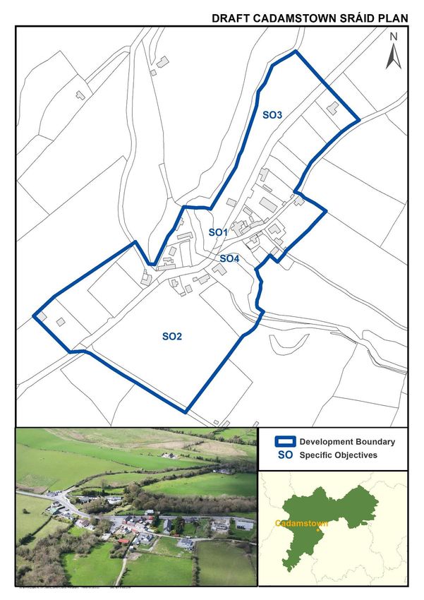
Offaly County Development Plan 2021-2027: Draft Stage
Sráid Plans
Cater for a number of small in-depth housing schemes with limited scope for small-scale multi-
house developments of up to 4 houses only, and cater for small-scale commercial
developments, which are appropriate in terms of scale, use and location within the Sráid.
Contain development in order to bring some form to the settlement and engender a sense of
place.
1.3 Services and Social Infrastructure
1.3.1 Water Supply and Wastewater Facilities
All the Sráid settlements have access to public/private water schemes (note: some schemes may
require a letter of consent to gain a connection to the supply). Where an individual site does not have
access to a public/private water supply, this site may be served by private bored wells; the suitability
of this will be assessed at planning application stage.
None of the Sráid settlements have public wastewater treatment facilities, currently. Proposals for
individual treatment systems will be assessed on their own merits by the planning authority at
planning application stage.
1.3.2 Broadband
A large number of Sráid settlements in Offaly have access to high speed broadband services or are
identified by commercial operators for delivery of high speed broadband services. In all other cases,
high speed broadband will be delivered by way of the National Broadband Plan State Intervention
Strategy.
1.3.3 Other Services
The Sráid settlements have a limited number of varied services such as a church, a school, a local shop,
or a sports field. It will be a key objective of any Sráid plan to maintain these services and expand
them where appropriate; each plan will identify opportunities that are relevant to the settlement in
question.
Some of the services typical to Sráids in Offaly include:
Church
National School
Community Hall and other facilities
Playground
GAA and other sporting facilities
Shops
Post Office
Licensed premises
4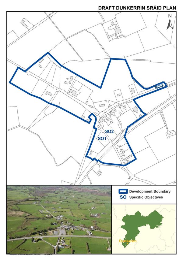
Offaly County Development Plan 2021-2027: Draft Stage
Sráid Plans
1.3.4 Other Features
The attractive rural character of the Sráid settlements is recognised. Specific features relating to
individual Sráids will be highlighted in the relevant Sráid plans for protection/enhancement, i.e.
attractive features, historic buildings.
1.3.5 Roads, footpaths and public lighting
Junction improvements, traffic calming, speed limit reviews are ongoing considerations for the
county’s Sráid settlements. Footpath provision and street lighting can be provided/expanded in every
Sráid, subject to feasibility. Where new developments are proposed within the development envelope
they will be required to ensure that safe pedestrian access is available.
1.4 General Development Objectives
The main objectives driving Sráid development are as follows:
Facilitate people to live in high quality and primarily low density housing in a rural location.
Maintain and enhance services at a local level.
1.4.1 Priorities
The following priorities are common to almost all Sráids and will be a material consideration in the
assessment of all planning applications in the Sráids of County Offaly:
Promotion and consolidation of balanced sustainable development, in an incremental manner
with the emphasis on small scale development over a medium to long term period, in keeping
with the character of the settlement and within the development boundary as shown on the
accompanying plan.
Improvement of the existing road network and provision of footpaths, particularly where
development is not served by footpaths, in conjunction with on-going development.
Create / reinforce ‘gateway’ features to engender a sense of place and delineate the Sráid.
Individual proposals in Sráid settlements should be predominantly single house, with limited
scope for small scale multi house developments of up to 4 houses only. Where a multi-unit
residential development (2 to 4 houses) is proposed within the boundary of a Sráid, the onus
will be on the developer to justify the demand for housing proposed, and to provide a Design
Statement.
Encourage and facilitate co-operation between / amongst the different development
interests in order to maximise community gain, for the greater good of the settlement.
Promotion of natural building and boundary materials.
Housing to be detached high quality only.
Bring a mainly rural feel to the settlements with sensitive landscaping.
5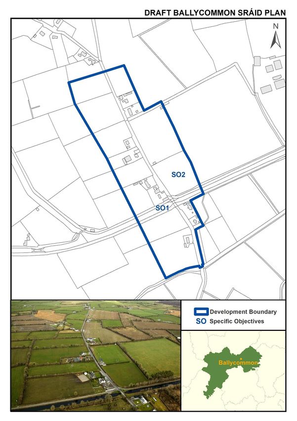
Offaly County Development Plan 2021-2027: Draft Stage
Sráid Plans

1.4.2 Shape and Form

The development boundaries shown on each accompanying settlement plan aim to create a more
compact and coherent settlement, utilising the existing roads, with new internal roads opening up the
surrounding backland areas, as appropriate to specific Sráids.

1.4.3 Design

All proposals shall be consistent with the Council’s policy on design as contained in the County
Development Plan 2021-2027, Chapter 13 relating to Development Management Standards, DMOs 35
to 44. As a measure to assist with an understanding of the form of development encouraged, sample
designed layouts for the Sráids of Croghan and Doon have been prepared and included at the end of
the Sráid Plan Guide.

1.4.4 Archaeology

It is an objective of the council to secure the protection (i.e. preservation in situ or at a minimum
protection by record) of all Recorded Monuments included in the Record of Monuments and Places
as established under Section 12 of the National Monuments (Amendment) Act 1994, and their setting.

1.4.5 Protected Structures

A complete list is contained within the Record of Protected Structures for the county. Policies
contained within Volume 1, of Chapter 10 will apply.

1.4.6 Zoning

 Lands within the Sráid boundaries are not formally zoned under this development plan.
 Map Annotation
 On the Settlement Maps, these indicate the specific objectives that the council require for the
 development of a coherent and properly planned Sráid settlement that they may be developed in
 a coherent and properly planned manner.

6
Offaly County Development Plan 2021-2027: Draft Stage
Sráid Plans

                                     Sample Sráids

                                                        7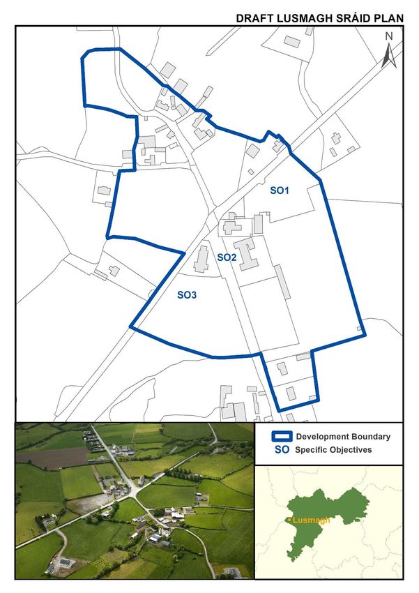
Offaly County Development Plan 2021-2027: Draft Stage
Sráid Plans

8
Offaly County Development Plan 2021-2027: Draft Stage
Sráid Plans

                                                        9
Offaly County Development Plan 2021-2027: Draft Stage
Sráid Plans

10
Offaly County Development Plan 2021-2027: Draft Stage
Sráid Plans

                                                        11
Offaly County Development Plan 2021-2027: Draft Stage
Sráid Plans
Ballinamere Sráid Plan
Settlement Description
Settlement Context: Ballinamere is located at a junction linking two county roads, approximately
4.3km west of Tullamore and 4km east of Rahan. The Ballykilmurray Esker which traverses to the
north of the Sráid, is of geomorphological importance and provides a natural attractive buffer.
Services and Facilities: National School, GAA grounds with walking track, Community Centre.
Waste Water Treatment: Individual effluent treatment systems.
Water Supply: Rahan Group Water Scheme. Western half of the Sráid is located within a groundwater
source protection zone.
Broadband: High speed broadband is available.
Settlement Objectives
General Objectives
Infrastructure and Public Realm
GO1 Further improvement of the existing road network, public lighting and footpaths.
GO2 Investigate traffic calming measures at the two road junctions within the Sráid.
GO3 Public realm enhancement works at school and GAA grounds.
GO4 Provide / enhance gateway features on the approaches to the Sráid.
GO5 As development of the Sráid progresses, preserve links to the backlands within the plan
boundary, for possible future development.
GO6 Improve cycle / pedestrian links to the Grand Canal Greenway.
Development and Design
GO7 The rural setting of Ballinamere shall be retained and enhanced, in accordance with
appropriately designed and sensitive development.
GO8 The conservation and integration into new development of existing stonewalls, trees and
native hedgerows.
GO9 Groundwater source protection zone must be protected.
Specific Objectives (refer to map)
SO1 The area is identified for amenity use.
SO2 Future development to make provision for a pedestrian / cycle track to link the National
School with the GAA grounds and walking track.
12Offaly County Development Plan 2021-2027: Draft Stage
Sráid Plans
13Offaly County Development Plan 2021-2027: Draft Stage
Sráid Plans
Ballyboy Sráid Plan
Settlement Description
Settlement Context: Ballyboy is located in the
foothills of the Slieve Bloom Mountains on the Silver
River, 2km east of Kilcormac. ‘Dan and Mollys’
licensed premises, with its thatched roof, acts as the
focal point of this settlement. A 12th century motte
is situated within Ballyboy and this moat contains the
remains of a 19th century limekiln built into its side.
The stonewalls are particularly prominent
throughout the Sráid and contribute greatly to the
attractiveness of the settlement.
Services and Facilities: Licenced premises, national
school, former community hall, bring centre, church
ruins and graveyard, river side picnic area.
Waste Water Treatment: Individual effluent treatment systems.
Water Supply: Private Group Water Scheme.
Broadband: High speed broadband is available.
Settlement Objectives
General Objectives
Infrastructure and Public Realm
GO1 Improvement of the existing road network and provision of public lighting and footpaths.
GO2 Provide/enhance gateway features on the approaches to the Sráid.
GO3 Provide a pedestrian crossing and improve car parking for the National School.
GO4 Provide appropriate new infrastructure and upgrades of existing infrastructure to meet
the needs of the Offaly Way walking route and Offaly Cycling Destination Network,
including an ‘Emerging Stop-Off Place’ identified for Ballyboy.
Development and Design
GO5 The conservation and integration into new development of existing stonewalls, trees and
native hedgerows.
GO6 Ballyboy can accommodate low density, sensitively designed housing on individual sites.
Each proposed development should include a design statement demonstrating that the
design and materials will contribute to and enhance the Sráid.
Specific Objectives (refer to map)
SO1 Facilitate and encourage the redevelopment and reuse of the former community hall.
SO2 Ensure that sufficient land is reserved to facilitate the future expansion of the national
school, if required.
SO3 Ensure that access to the Silver River and Offaly Way is maintained and improved where
necessary, including the provision of a footpath and lighting connecting the Sráid core to
the river side amenity / picnic area adjacent to the bridge.
14Offaly County Development Plan 2021-2027: Draft Stage
Sráid Plans
15Offaly County Development Plan 2021-2027: Draft Stage
Sráid Plans
Ballycommon Sráid Plan
Settlement Description
Settlement Context: Ballycommon is a small
rural settlement located on a local road
adjacent to its crossing of the Grand Canal,
approximately 8km east of Tullamore. A
licenced premises, GAA grounds and the Grand
Canal bridge form the focal points of the
settlement.
Services and Facilities: Licenced premises,
tourist accommodation, GAA grounds and the
Grand Canal. Ballycommon Project Centre and
Training Centre are situated north of the Sráid.
Waste Water Treatment: Individual effluent treatment systems.
Water Supply: Private Group Water Scheme.
Broadband: High speed broadband is available.
Settlement Objectives
General Objectives
Infrastructure and Public Realm
GO1 Provision of public footpaths and street lighting.
GO2 Provide/enhance gateway features on the approaches to the Sráid.
GO3 Provision of measures to improve traffic calming on approach to the Sráid.
GO4 Support the provision of appropriate infrastructural requirements to meet the needs of
the Offaly Cycling Destination Network.
GO5 Provision of public facilities and amenities, including car and cycle parking, to promote the
Sráid as a trailhead on the Grand Canal Greenway and Offaly Cycling Destination Network.
GO6 Enhance the public realm.
Development and Design
GO7 The conservation and integration into new development of existing native hedgerows.
GO8 The unique rural setting of Ballycommon shall be retained and enhanced, in accordance
with appropriately designed and sensitive development.
GO9 Development to have a minimal impact on the setting of the bridge over the Grand Canal.
Specific Objectives (refer to map)
SO1 As per Policy BHP-27 (Chapter 10, Volume 1) the Council will restrict vehicular access onto
public roads that were formerly towpaths and any development permitted with access off
a towpath must be screened effectively with trees and hedging.
SO2 Any development shall incorporate screen planting on the boundary to the GAA grounds.
16Offaly County Development Plan 2021-2027: Draft Stage
Sráid Plans
17Offaly County Development Plan 2021-2027: Draft Stage
Sráid Plans
Ballyfore Sráid Plan
Settlement Description
Settlement Context: Ballyfore is a small rural
settlement, located at a crossroads linking two
roads, namely the R402 (Tullamore to
Edenderry) and the L‐05006. This settlement is
located approximately 4.5km southwest of the
town of Edenderry and approximately 13.6km
northeast of the town of Daingean. The
settlement at Ballyfore is very traditional in
origin, given its location at a crossroads in the
road network. The existing development is
predominantly linear in nature with a number
of detached houses on large sites, with a small number of farmsteads also sited within this area.
Services and Facilities: Ballyfore GAA grounds are located 1.5km to the southwest.
Waste Water Treatment: Individual effluent treatment systems.
Water Supply: Private Group Water Scheme.
Broadband: High speed broadband is available.
Settlement Objectives
General Objectives
Infrastructure and Public Realm
GO1 Improvement of the existing road network and provision of public lighting and footpaths.
GO2 Preserve links to backlands for possible future development.
GO3 A planting scheme should be devised for the Sráid to introduce amenity to the area.
GO4 Create a natural buffer between the Sráid and the R402, along the Sráid’s western
boundary i.e. soft landscaping/planting.
Development and Design
GO5 Promotion of very low‐density development within the development boundary.
GO6 Any new development should be based upon a considered understanding of the area’s
character and shall be designed and located in a way that sympathetically reflects and
respects the rural character of the area.
Specific Objectives (refer to map)
SO1 Develop the green triangular area as a focal point for the settlement.
18Offaly County Development Plan 2021-2027: Draft Stage
Sráid Plans
19Offaly County Development Plan 2021-2027: Draft Stage
Sráid Plans
Blueball Sráid Plan
Settlement Description
Settlement Context: Blueball is a rural settlement
located approximately 10km south west of
Tullamore. The settlement has evolved around the
junction of the N52 national secondary road with
the R357 regional road and the L-01012 local road.
Services and Facilities: Health Centre, Public House,
Service Station with convenience shop, off-licence
and café with seating area.
Waste Water Treatment: Individual effluent
treatment systems.
Water Supply: Public mains.
Broadband: To be delivered under the State Intervention of the National Broadband Plan.
Settlement Objectives
General Objectives
Infrastructure and Public Realm
GO1 Continue to maintain the existing network of stonewalls within the settlement boundary.
GO2 Further improvement of the existing road network. Upgrade and extend provision of
footpaths and lighting, where feasible, within the Sráid.
GO3 Review speed limits within the Sráid.
Development and Design
GO4 Continue to create consistency/continuity/simplicity in the development of footpaths,
grass verges and boundary treatment (i.e. stone walls, hedgerows and types of
landscaping/planting - native planting only).
GO5 Promotion of very low-density linear and cluster type development within the
development boundary.
GO6 Any new development should be designed and located in a way that sympathetically
reflects and respects the rural character of the area.
Specific Objectives (refer to map)
SO1 Any development taking place on lands that have views towards Pallas Lough and/or Pallas
Castle should respect and reflect this unique landscape.
SO2 Subject to appropriate servicing, this area could potentially be developed in a
comprehensive manner. Access onto the N52 should be kept to a minimum.
SO3 Any residential development in this area should include a tree planting scheme to provide
a suitable buffer to the existing commercial uses which front the N52 to the west.
SO4 Examine the feasibility of upgrading this road to function as a shared surface for cars and
pedestrians.
20Offaly County Development Plan 2021-2027: Draft Stage
Sráid Plans
21Offaly County Development Plan 2021-2027: Draft Stage
Sráid Plans
Boher Sráid Plan
Settlement Description
Settlement Context: Boher is a small rural
settlement located on the L‐07001‐1 road and
on the L30026‐1. It is situated approximately
2km west of Ballycumber and 6km east of
Doon. A tributary of the Brosna River flows
south of the existing settlement. The Roman
Catholic Church is the focal point of this
settlement and is strategically located on the
highest point within the development
boundary.
Services and Facilities: Church, parish hall,
graveyard and National School.
Waste Water Treatment: Individual effluent treatment systems.
Water Supply: Boher Group Water Scheme.
Broadband: High speed broadband is available.
Settlement Objectives
General Objectives
Infrastructure and Public Realm
GO1 Further improvement of the existing road network, public lighting and footpaths.
GO2 Public realm enhancement works at school, graveyard car park and water pumping station.
GO3 Gateway features and measures to improve traffic calming on approach to Sráid.
GO4 Provision of appropriate infrastructural improvements to meet the needs of any future
extension of the Offaly Way.
GO5 Groundwater source protection zone must be protected.
Development and Design
GO6 In recognition of its archaeological, architectural and historical significance high quality
development will be encouraged which is reflective of the unique character of the area.
GO7 Promotion of small scale, high quality design, very low‐density linear development within
the development boundary.
Specific Objectives (refer to map)
SO1 Reserve lands to facilitate the provision of further extensions of the existing National
School, where necessary.
SO2 Any proposed development on these lands must demonstrate its compatibility with likely
requirements for the extension of the existing cemetery and also demonstrate suitability
in design /layout for its sensitive location.
22Offaly County Development Plan 2021-2027: Draft Stage
Sráid Plans
23Offaly County Development Plan 2021-2027: Draft Stage
Sráid Plans
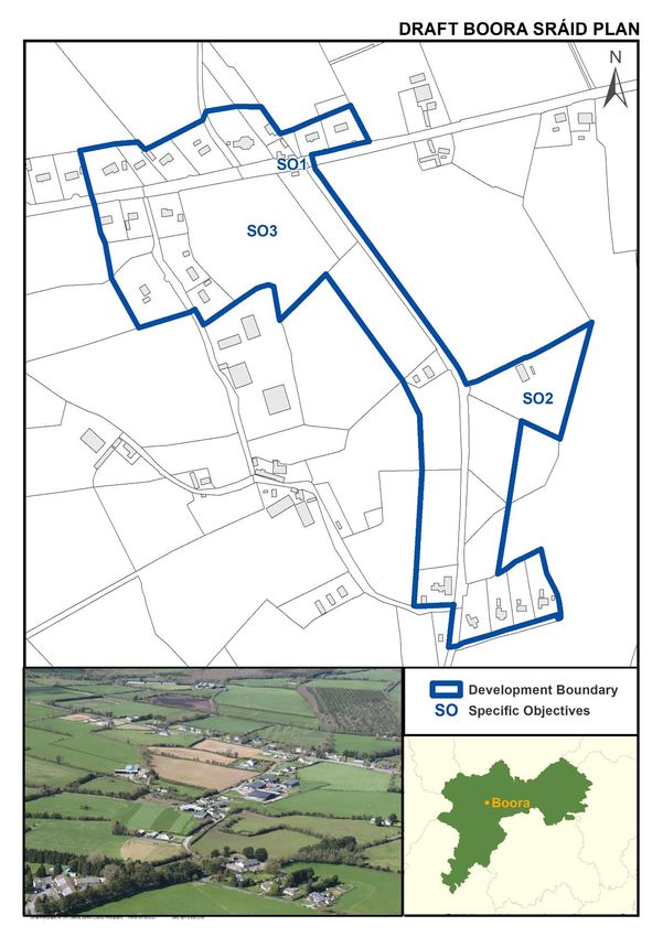
Boora (Leabeg) Sráid Plan
Settlement Description
Settlement Context: Boora (Leabeg) is located
on the R357 Cloghan to Blueball road,
approximately 10km east of Cloghan and 8km
northwest of Blueball. The settlement adjoins
Lough Boora Discovery Park, with the ‘Offaly
Way’ walking route to the west of the Sráid.
The focal point of the Sráid is the Roman
Catholic Church, together with a licensed
premises and the ‘Teach Lea’ community
centre further south, on the approach road to
the Lough Boora Discovery Park.
Services and Facilities: Catholic Church,
Community Centre and Licenced Premises.
Waste Water Treatment: Individual effluent treatment systems.
Water Supply: Private Group Water Scheme.
Broadband: High speed broadband is available.
Settlement Objectives
General Objectives
Infrastructure and Public Realm
GO1 Improvement of the existing road network and provision of public lighting and footpaths.
GO2 Provide/enhance gateway features on the approaches to the Sráid.
GO3 Provide traffic calming measures on the approaches to the Sráid and the road junctions
within the Sráid.
GO4 Restrict development onto the Regional Route R357.
Development and Design
GO5 The conservation and integration into new development of existing stone walls, trees and
native hedgerows.
GO6 All new development should respect the predominantly rural nature of the settlement, in
particular through the provision of sensitive landscaping.
GO7 Development to have a minimal impact on the Lough Boora Discovery Park A.H.A.
Specific Objectives (refer to map)
SO1 Provide appropriate new infrastructure and upgrades of existing infrastructure to meet
the needs of the Offaly Cycling Destination Network, Offaly Way walking route and
Greenway links between the Grand Canal and Lough Boora Discovery Park.
SO2 Support a diversity of community uses at the Teach Lea Community Centre.
SO3 These lands should only be developed for low density clustered style development.
Vehicular access from the R357 should be restricted.
24Offaly County Development Plan 2021-2027: Draft Stage
Sráid Plans
25Offaly County Development Plan 2021-2027: Draft Stage
Sráid Plans
Brosna Sráid Plan
Settlement Description
Settlement Context: Brosna is located at
the junction between Local Primary
Routes LP4011 and LP4009, approximately
3km east of Shinrone and 12km south of
Birr. The centre point of this Sráid consists
of a very traditional street type
arrangement located at the T‐Junction. A
pump with well-maintained flower beds is
located close to the T‐junction and a
bespoke iron bench with the name of the
Sráid is a distinctive landmark.
Waste Water Treatment: Individual
effluent treatment systems.
Water Supply: Public mains.
Broadband: High speed broadband is available.
Settlement Objectives
General Objectives
Infrastructure and Public Realm
GO1 Improvement of the existing road network.
GO2 Provision of public lighting and footpaths.
GO3 Public realm enhancement works.
GO4 Provide/enhance gateway features on the approaches to the Sráid.
GO5 Promote the Sráid as a potential stop-off destination as part of a future greenway on the
former Birr to Roscrea railway line.
Development and Design
GO6 The rural setting of Brosna shall be retained and enhanced, in accordance with
appropriately designed and sensitive development.
GO7 The conservation and integration into new development of existing stone walls, trees and
native hedgerows.
GO8 Facilitate and encourage redevelopment and reuse of vacant and derelict buildings.
Specific Objectives (refer to map)
SO1 Examine possible measures to enhance road safety at the T-junction within the Sráid.
SO2 Mature trees along the road boundary to be preserved as part of any development.
26Offaly County Development Plan 2021-2027: Draft Stage
Sráid Plans
27Offaly County Development Plan 2021-2027: Draft Stage
Sráid Plans
Cadamstown Sráid Plan
Settlement Description
Settlement Context: Cadamstown is a rural
settlement on the north-western flank of the
Slieve Bloom Mountains, located on the R421
where it crosses the Silver River, 6km northeast
of Kinnitty. A licenced premises and the Silver
River bridge are the focal points of the Sráid.
Services and Facilities: Catholic Church,
licenced premises.
Waste Water Treatment: Individual effluent
treatment systems.
Water Supply: Private Group Water Scheme.
Broadband: High speed broadband is available.
Settlement Objectives
General Objectives
Infrastructure and Public Realm
GO1 Improve road network, junctions, public lighting and footpaths and provide/enhance
gateway features on the approaches to the Sráid.
GO2 Support the provision of appropriate infrastructural requirements to meet the needs of
the Slieve Bloom Way, the Offaly Way and the Silver River Eco Walk.
Development and Design
GO3 New development should be designed and located in a way that sympathetically reflects
and respects the rural character of the area.
GO4 Promotion of low‐density linear or cluster style development within the Sráid boundary.
GO5 Ensure the protection of archaeological sites, as identified within this settlement.
GO6 Development to have a minimal impact on the Area of High Amenity associated with the
Slieve Bloom Mountains.
GO7 Facilitate and encourage redevelopment and reuse of vacant and derelict buildings.
Specific Objectives (refer to map)
SO1 Enhance the public realm, including formalisation of car parking, in the vicinity of the
licenced premises and adjacent to the Silver River.
SO2 These lands should only be developed for low density clustered style development. Access
should be restricted to retain as a feature the stone wall / hedge / stream along the
boundary to the R421. Development should provide for a pedestrian link to form part of
the Silver River loop walk.
SO3 Reserve this area for future river side linear park / public amenity space.
SO4 Extend and improve the amenity walkways related to the Silver River Eco Walk and Slieve
Bloom Way.
28Offaly County Development Plan 2021-2027: Draft Stage
Sráid Plans
29Offaly County Development Plan 2021-2027: Draft Stage
Sráid Plans
Clareen Sráid Plan
Settlement Description
Settlement Context: Clareen is a rural settlement
situated in the western foothills of the Slieve
Bloom Mountains on the R421 road, located
approximately 20km from Tullamore and 6kms
from Kinnitty. The Sráid boundary includes the
historically significant St. Kieran (Seir Kieran)
monastic site.
Services and Facilities: Catholic Church, graveyard,
national school, parish hall, GAA grounds.
Waste Water Treatment: Individual effluent
treatment systems.
Water Supply: Private Group Water Scheme.
Broadband: High speed broadband is available.
Settlement Objectives
General Objectives
Infrastructure and Public Realm
GO1 Improvement of the existing road network, public lighting and footpaths.
GO2 Extend footpath and public lighting from the Sráid crossroads to the Seir Kieran Monastery
entrance and also connecting the existing footpath network to the cemetery to the north.
GO3 Enhance gateway features and traffic calming measures on the approaches to the Sráid.
GO4 Carry out public realm enhancement works at the GAA grounds and Church car park.
GO5 Support the erection of a wall plaque or similar commendation in honour of local cyclist JJ
Kinahan.
GO6 Encourage the development of pollinator friendly zones within the Sráid.
Development and Design
GO7 Promotion of low‐density linear or cluster style development within the Sráid boundary.
GO8 Any new development should be designed and located in a way that sympathetically
reflects and respects the rural character of the area.
Specific Objectives (refer to map)
SO1 These lands should be developed for low density linear or clustered style development.
Any cluster proposal must make provision for a publically accessible linear park and
pedestrian walkway along the existing stream.
SO2 Consult with the Office of Public Works to investigate the potential for tourism
opportunities at the Seir Kieran Monastery site, together with improved public access to
the monastic site, including pedestrian connections from the Sráid.
SO3 Any further development of these lands should be required to include a comprehensive
landscaping strategy to improve the visual amenity of the area.
SO4 Encourage and support the refurbishment of the Parish Hall.
30Offaly County Development Plan 2021-2027: Draft Stage
Sráid Plans
31Offaly County Development Plan 2021-2027: Draft Stage
Sráid Plans
Clonfinlough Sráid Plan
Settlement Description
Settlement Context: Clonfinlough is a small
rural settlement, rich in heritage, located
within the west of the county. It is situated
approximately 4km east of Clonmacnoise, 8km
west of Doon and 10km southeast of
Shannonbridge. The Roman Catholic Church is
the focal point of this Sráid and is located on
elevated ground.
Services and Facilities: Church and Parish Hall.
Waste Water Treatment: Individual effluent
treatment systems.
Water Supply: Private Group Water Scheme.
Broadband: To be delivered under the State Intervention of the National Broadband Plan.
Settlement Objectives
General Objectives
Infrastructure and Public Realm
GO1 Improvement of the existing road network and provision of public lighting and footpaths.
GO2 Provide/enhance gateway features on the approaches to the Sráid.
GO3 Provision of signage where appropriate to direct to features of interest in the area.
GO4 Support the provision of appropriate infrastructural requirements to meet the needs of
the Offaly Cycling Destination Network, including signage, bicycle stands, seating, etc.
Development and Design
GO5 High quality development will be encouraged in recognition of Clonfinlough’s
archaeological, ecological, cultural and historical significance.
GO6 Promotion of small scale, high quality design, very low‐density linear development within
the development envelope.
GO7 Ensure the protection of archaeological sites in the vicinity of the development envelope.
GO8 Groundwater source protection zone must be protected.
G9 Development to have a minimal impact on the Area of High Amenity associated with the
Shannon Callows and only sensitively designed development shall be considered.
Specific Objectives (refer to map)
SO1 Provide new footpath and public lighting between the Church and Parish Hall.
SO2 Car parking and public realm enhancement works in the vicinity of the Parish Hall.
SO3 Formalise car and cycle parking together with a footpath connection to the pedestrian
gateway access to Clonfinlough Stone (National Monument Ref, OF006-038).
32Offaly County Development Plan 2021-2027: Draft Stage
Sráid Plans
33Offaly County Development Plan 2021-2027: Draft Stage
Sráid Plans
Croghan Sráid Plan
Settlement Description
Settlement Context: Croghan is a rural settlement,
located 6km west of Rhode. The settlement is
traditional in origin, given its location at a point at
which three roads converge. Croghan Hill creates an
attractive backdrop to the settlement, to which
improved visitor access has been provided.
Services and Facilities: National School, local
shop/office. Community centre, Catholic Church and
GAA grounds are located outside of the Sráid
development boundary.
Waste Water Treatment: Individual effluent treatment systems.
Water Supply: Rhode Public Water Scheme.
Broadband: To be delivered under the State Intervention of the National Broadband Plan.
Settlement Objectives
General Objectives
Infrastructure and Public Realm
GO1 Improvement of the existing road network and provision of public lighting and footpaths,
in conjunction with future development.
GO2 Preserve links to backlands within the development boundary for possible future
development.
GO3 Provide/enhance gateway features on the approaches to the village.
GO4 Support the provision of appropriate infrastructural requirements to meet the needs of
the Offaly Cycling Destination Network, and promotion of Croghan Hill as a focal point.
Development and Design
GO5 The unique rural setting of Croghan shall be retained and enhanced, in accordance with
appropriately designed and sensitive development.
GO6 The conservation and integration into new development of existing stonewalls, trees and
native hedgerows, with site design to have regard to the Croghan Sample Sráid Design
Statement.
GO7 Ensure the protection of archaeological sites, as identified within this settlement.
GO8 Development to have a minimal impact on the Area of High Amenity (Croghan Hill).
Specific Objectives (refer to map)
SO1 Existing natural stone walls along the front boundary should be retained.
SO2 The mature trees along the roadside boundary of these lands should be retained.
SO3 The sod and stone ditch along the roadside boundary should be retained.
SO4 Ensure that sufficient land is reserved to facilitate the expansion of the national school.
34Offaly County Development Plan 2021-2027: Draft Stage
Sráid Plans
35Offaly County Development Plan 2021-2027: Draft Stage
Sráid Plans
Doon Sráid Plan
Settlement Description
Settlement Context: Doon is located on the
junction between the R444 and the N62, 6km
north of Ferbane. The Sráid currently
comprises a small number of one‐off dwellings
on individual sites which are located along the
R444. A licensed premises forms the focal
point for the settlement.
Services and Facilities: Licenced Premises and
GAA grounds.
Waste Water Treatment: Individual effluent
treatment systems.
Water Supply: Private Group Water Scheme.
Broadband: High speed broadband is available.
Settlement Objectives
General Objectives
Infrastructure and Public Realm
GO1 Improvement of the existing road network, public lighting and footpaths, particularly
between the junction of the N62/R444 and the GAA pitch.
GO2 All development associated with the Sráid will be directed to the west of the N62 in order
to protect its carrying capacity.
GO3 Gateway features and measures to improve traffic calming on approach to Sráid.
GO4 Support the provision of appropriate infrastructural requirements to meet the needs of
the Offaly Cycling Destination Network.
Development and Design
GO5 The conservation and integration into new development of existing trees and native
hedgerows.
GO6 Promote very low‐density linear, street style or clustered style development within the
Sráid, with site design to have regard to the Doon Sample Sráid Design Statement.
Specific Objectives (refer to map)
SO1 Existing natural stone walls along the front boundary of sites should be retained. Any
development on these lands must be sensitively designed.
36Offaly County Development Plan 2021-2027: Draft Stage
Sráid Plans
37Offaly County Development Plan 2021-2027: Draft Stage
Sráid Plans
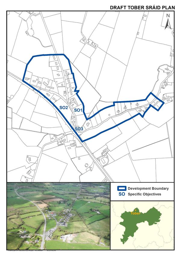
Dunkerrin Sráid Plan
Settlement Description
Settlement Context: Dunkerrin is located just
north of the R445 (old N7 Dublin to Limerick
road), 6.5km northeast of Moneygall and 9km
southwest of Roscrea. The settlement at
Dunkerrin is very traditional in origin, given its
location at a junction in the road network. Its
attraction lies in the tight knit order of
development which currently exists at the
crossroads. The centre of the Sráid and the
junction forms a triangle area where there is
potential for additional planting or a civic feature.
Services and Facilities: Catholic Church,
graveyard, national school, Church of Ireland with graveyard, funeral home, convenience shop with
post office, licenced premises, former hotel, kitchen showroom, community centre.
Waste Water Treatment: Individual effluent treatment systems.
Water Supply: Public water mains.
Broadband: High speed broadband is available.
Settlement Objectives
General Objectives
Infrastructure and Public Realm
GO1 Improvement of the existing road network, public lighting and footpaths. Extend footpath
and public lighting to connect the Sráid core to the graveyard.
GO2 Provide/enhance gateway features and traffic safety measures on the approaches to the
Sráid, and traffic safety measures in the vicinity of the school.
GO3 Enhance the public realm including the diamond junction within the centre of the Sráid.
Development and Design
GO4 The conservation and integration into new development of existing stonewalls, trees and
native hedgerows.
GO5 Dunkerrin can accommodate low density, sensitively designed housing on individual sites.
Each proposed development should include a design statement demonstrating that the
design and materials will contribute to and enhance the Sráid.
Specific Objectives (refer to map)
SO1 Development in this area should comprise double fronted buildings to address the local
road to the east and R445 to the south, and should also provide a landscaped buffer to the
R445. Access to this land should be restricted from the R445.
SO2 Development in this area should be subject to a masterplan to facilitate development in a
planned, coordinated and sustainable manner.
SO3 Support continued use of the public amenity space adjacent to the community centre, and
provide a footpath connection from the amenity space to the Sráid core.
38Offaly County Development Plan 2021-2027: Draft Stage
Sráid Plans
39Offaly County Development Plan 2021-2027: Draft Stage
Sráid Plans
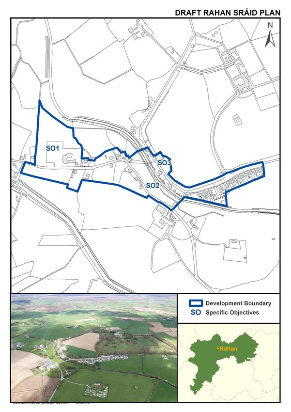
Durrow Sráid Plan
Settlement Description
Settlement Context: Durrow is located on the
N52, 7km north of Tullamore. Durrow Church
and the primary school are the focal point of
the settlement.
Services and Facilities: Roman Catholic Church,
graveyard, national school, childcare facility
and community centre. A GAA pitch and
associated facilities are situated outside of the
development boundary.
Waste Water Treatment: Individual effluent
treatment systems.
Water Supply: Private Group Water Scheme.
Broadband: High speed broadband is available.
Settlement Objectives
General Objectives
Infrastructure and Public Realm
GO1 Improvements / extensions of public footpaths and street lighting, where required.
GO2 A planting scheme should be devised for the village to ensure that the existing mature
trees, which greatly add to the village setting, are being replenished over time.
GO3 Sráid development to the east of the N52 only, to protect the carrying capacity of the road.
GO4 Investigate measures for traffic safety at the junction between the L2006 and N52.
Development and Design
GO5 The conservation and integration into new development of existing trees and native
hedgerows.
GO6 Development shall be directed so as to have a minimal impact on the Area of High Amenity
(Esker Riada) and only appropriately designed and sensitive development shall be
considered.
G07 Groundwater source protection zone must be protected
GO8 Due regard shall be had to the alignment of the future N52 Tullamore - Kilbeggan link road.
Specific Objectives (refer to map)
SO1 Ensure that sufficient land is reserved to facilitate the future expansion of the national
school, if required.
SO2 Development shall incorporate screen planting, on the northern boundary, in particular.
SO3 Land reserved for the future expansion of the church graveyard.
40Offaly County Development Plan 2021-2027: Draft Stage
Sráid Plans
41Offaly County Development Plan 2021-2027: Draft Stage
Sráid Plans
Fivealley Sráid Plan
Settlement Description
Settlement Context: Fivealley is located on the N52,
approximately 23km west of Tullamore, 8km west of
Kilcormac and 7.5km east of Birr. The existing
settlement at Fivealley originated in a traditional
fashion at a crossroads junction in the road network.
Lands included within the Sráid boundary at Fivealley
are situated to the north of the N52 and whilst set
back from this national secondary road, are
accessible by two approaches. These are both
attractively landscaped. The ‘Fivealley Inn’ licensed
premises/restaurant and guest accommodation
provides the focal point for the settlement.
Services and Facilities: Licenced premises. St. James Roman Catholic Church and graveyard, which
serves the parish of Eglish, is located approximately 0.6km southwest of the Sráid boundary.
Waste Water Treatment: Individual effluent treatment systems.
Water Supply: Private Group Water Scheme.
Broadband: High speed broadband is available.
Settlement Objectives
General Objectives
Infrastructure and Public Realm
GO1 Improvement of the existing road network and provision of public lighting and footpaths.
GO2 Provide/enhance gateway features on the approaches to the Sráid.
GO3 Sráid development north of the N52 only, to protect the carrying capacity of the road.
GO4 A planting scheme should be devised for the village to ensure that the existing mature
trees, which greatly add to the village setting, are being replenished over time.
GO5 Improvements to the junctions between the N52 and local roads within the Sráid,
particularly the junction on the northern side of the Sráid.
Development and Design
GO6 The conservation and integration into new development of existing stonewalls, trees and
native hedgerows.
GO7 The Council will promote very low-density linear, street style or clustered style
development within the Sráid.
Specific Objectives (refer to map)
SO1 Any development proposed in this area is to include the following elements: (i) access
ways, providing for possible future expansion of backlands, (ii) open space provision,
forming a focal point at the southern corner of these lands to be considered.
SO2 These lands are to be retained as passive open space, providing an attractive natural buffer
along the N52.
42Offaly County Development Plan 2021-2027: Draft Stage
Sráid Plans
43Offaly County Development Plan 2021-2027: Draft Stage
Sráid Plans
Garryhinch Sráid Plan
Settlement Description
Settlement Context: Garryhinch is located on a
busy crossroads between the R423
Portarlington to Mountmellick road and a
county road which leads to Clonygowen to the
north. This settlement is located
approximately 5km west of Portarlington and
5.5km northeast of Mountmellick. The River
Barrow, which marks the county boundary with
County Laois traverses lands to the south and
east of the settlement. Cloneyhurke Church,
located at these crossroads, forms an attractive
centre point in the settlement.
Services and Facilities: Church of Ireland Church. Garryhinch Wood and Barrow River Walking Trails
located east and southeast of the settlement.
Waste Water Treatment: Individual effluent treatment systems.
Water Supply: Private Group Water Scheme.
Broadband: High speed broadband is available.
Settlement Objectives
General Objectives
Infrastructure and Public Realm
GO1 Improvement of the existing road network and provision of public lighting and footpaths
in conjunction with on‐going development.
GO2 Underground cables/wires in vicinity of settlement.
GO3 Examine the feasibility of linking the Sráid to Garryhinch Wood and Barrow River walking
trails.
GO4 Provide/enhance gateway features on the approaches to the village.
Development and Design
GO5 The rural setting of Garryhinch shall be retained and enhanced, in accordance with
appropriately designed and sensitive development.
GO6 The conservation and integration into new development of existing stonewalls, trees and
native hedgerows.
GO7 Restrict development in line with Strategic Flood Risk Assessment on lands which are
subject to flooding within the Sráid development boundary.
Specific Objectives (refer to map)
SO1 Examine possible measures to enhance road safety at the crossroads.
44Offaly County Development Plan 2021-2027: Draft Stage
Sráid Plans
45Offaly County Development Plan 2021-2027: Draft Stage
Sráid Plans
High Street Sráid Plan
Settlement Description
Settlement Context: High Street is situated
approximately 1km west of Belmont village, 8km
north of Cloghan village and 5km north east of
Shannonharbour. The centre of High Street consists
of a traditional type arrangement located at a T‐
Junction in the road network, with a Roman Catholic
Church, adjoining cemetery and community centre
situated at the focal point.
Services and Facilities: Catholic Church, graveyard,
national school and community centre.
Waste Water Treatment: Individual effluent treatment systems.
Water Supply: Clara/Ferbane Regional Water Supply Scheme.
Broadband: High speed broadband is available.
Settlement Objectives
General Objectives
Infrastructure and Public Realm
GO1 Improvements / extensions of public footpaths and street lighting, where required.
GO2 Continue to maintain and paint existing block walls and elements of interest in the Sráid
including the old pump, outdoor furniture, letter box. etc.
GO3 Undergrounding of overhead cables within the Sráid development boundary.
GO4 Provide / enhance gateway features on the approaches to the Sráid.
Development and Design
GO5 The conservation and integration into new development of existing stone walls, trees and
native hedgerows.
GO6 All new development will respect the predominantly rural nature of the settlement, in
particular through the provision of sensitive landscaping.
Specific Objectives (refer to map)
SO1 Carry out traffic safety and traffic calming measures at the crossroads in the Sráid, with a
priority to improve traffic sightlines at approach roads to the junction.
SO2 Provide pedestrian crossing between the church and community hall.
SO3 Ensure that sufficient land is reserved to facilitate the future expansion of the cemetery, if
required.
46Offaly County Development Plan 2021-2027: Draft Stage
Sráid Plans
47Offaly County Development Plan 2021-2027: Draft Stage
Sráid Plans
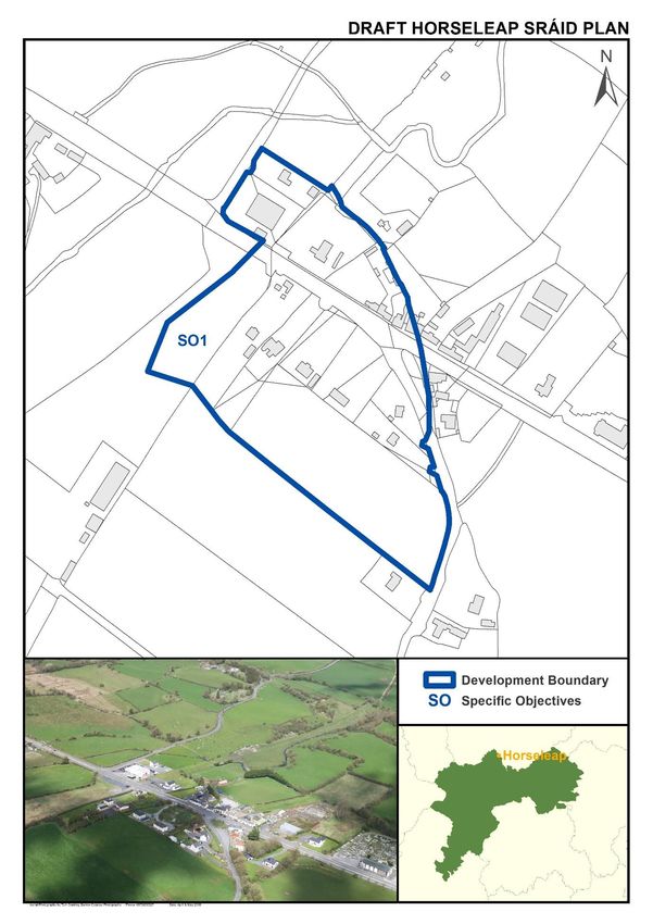
Horseleap Sráid Plan
Settlement Description
Settlement Context: Horseleap is a small
settlement located on the R446 road, at the
junction between the R446 and R391. It is also
located along the Westmeath‐Offaly county
boundary. Due regard therefore will be afforded to
plans/proposals put forward by Westmeath County
Council.
Services and Facilities: National School, Licensed
premises, car sales and convenience store. The
Catholic Church and cemetery are located within
the jurisdiction of Westmeath County Council.
Waste Water Treatment: Individual effluent treatment systems.
Water Supply: Public mains.
Broadband: High speed broadband is available.
Settlement Objectives
General Objectives
Infrastructure and Public Realm
GO1 Improvements / extensions of public footpaths and street lighting, where required, and in
conjunction with housing development on land off the R391.
GO2 Enhancement of local infrastructure along all routes within the settlement.
GO3 Ensure the provision of sufficient land to facilitate the future expansion of community
facilities.
GO4 Co‐operate with Westmeath County Council in an integrated approach to promote the
coherent planning of the settlement.
Development and Design
GO5 Any new development within the Sráid boundary should be based upon a considered
understanding of the area’s character and shall be designed and located in such a way that
sympathetically reflects and respects the area’s very rural character.
GO6 Promotion of small scale, high quality design, very low‐density linear development within
the development boundary.
Specific Objectives (refer to map)
SO1 Precautionary approach to development of lands that may be at risk of flooding from the
River Gageborough, which flows close to the western boundary of the Sráid.
48Offaly County Development Plan 2021-2027: Draft Stage
Sráid Plans
49Offaly County Development Plan 2021-2027: Draft Stage
Sráid Plans
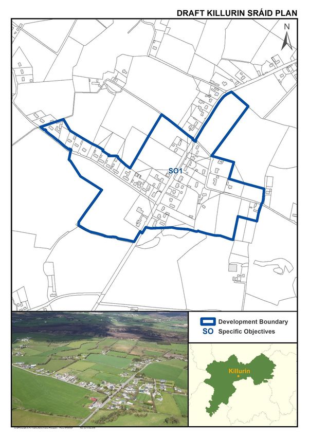
Kilclonfert Sráid Plan
Settlement Description
Settlement Context: Kilclonfert is a small
rural settlement, located 10km northeast
of Tullamore and 5km northwest of
Daingean. The Catholic Church and
Kilclonfert GAA Club Durrow Church form
the focal points of the settlement.
Services and Facilities: Church, graveyard,
GAA grounds and Community Centre. St.
Coleman’s National School is located
outside the Sráid boundary.
Waste Water Treatment: Individual
effluent treatment systems.
Water Supply: Private Group Water Scheme.
Broadband: To be delivered under the State Intervention of the National Broadband Plan.
Settlement Objectives
General Objectives
Infrastructure and Public Realm
GO1 Improvement of the existing road network.
GO2 Provision of public lighting and footpaths.
GO3 Public realm enhancement works.
GO4 Provide/enhance gateway features on the approaches to the Sráid.
Development and Design
GO5 The rural setting of Kilclonfert shall be retained and enhanced, in accordance with
appropriately designed and sensitive development.
GO6 The conservation and integration into new development of existing stone walls, trees and
native hedgerows.
Specific Objectives (refer to map)
SO1 Examine possible measures to enhance road safety at the T-junction within the Sráid.
SO2 Formalisation of car parking and public realm enhancement works at the GAA grounds.
SO3 Create a public amenity / seating area at this location, in conjunction with the provision of
footpaths and street lighting.
50You can also read