Volume 2: Villages - Offaly County Council
←
→
Page content transcription
If your browser does not render page correctly, please read the page content below

Volume 2: Villages
Offaly County Development Plan 2021-2027: Draft Stage
Village Plans

Table of Contents
Ballinagar Village Plan ............................................................................................................................. 3
Ballycumber Village Plan ......................................................................................................................... 5
Belmont Village Plan ............................................................................................................................... 8
Bracknagh Village Plan .......................................................................................................................... 10
Cloghan Village Plan .............................................................................................................................. 12
Clonbullogue Village Plan...................................................................................................................... 15
Cloneygowan Village Plan ..................................................................................................................... 18
Coolderry Village Plan ........................................................................................................................... 20
Geashill Village Plan .............................................................................................................................. 22
Killeigh Village Plan ............................................................................................................................... 25
Kinnitty Village Plan .............................................................................................................................. 28
Moneygall Village Plan .......................................................................................................................... 31
Mountbolus Village Plan ....................................................................................................................... 34
Mucklagh Village Plan ........................................................................................................................... 36
Pollagh / Lemanaghan Village Plan ....................................................................................................... 39
Rhode Village Plan ................................................................................................................................ 41
Riverstown Village Plan......................................................................................................................... 44
Shannon Harbour Village Plan .............................................................................................................. 47
Shannonbridge Village Plan .................................................................................................................. 49
Shinrone Village Plan ............................................................................................................................ 52
Walsh Island Village Plan ...................................................................................................................... 55

2
Offaly County Development Plan 2021-2027: Draft Stage
Village Plans

Ballinagar Village Plan
Settlement Description
Settlement Context: Ballinagar is located between
Tullamore and Edenderry at the junction of the R402 and
the L2025. It is approximately 12km from Tullamore and
24km from Edenderry. The original settlement is likely to
have developed as a cluster at the fording point on the local
stream, and the road junction. Modern expansion to the
village has taken a linear form along the constituent roads.
Since 2000 there has been a number of residential housing
developments constructed, giving added depth to the
village.
Population Census 2016: 453 (+ 7.9 % since Census 2011)
Services and Facilities: Roman Catholic Church, Community Hall, National School, Bring Centre, GAA
Grounds, Graveyard, Pub, Service Station, Ballinagar Group Water Scheme Office, Beauty Salon, Pre-
School and After-School Facility. Ballinagar is served by Bus Eireann’s No. 120 bus route from Dublin
to Tullamore.
Waste Water Treatment: Ballinagar Waste Water Treatment Plant
Water Supply: Ballinagar Private Group Water Scheme
Broadband: High Speed Fibre Broadband
Settlement Objectives
Housing and Sustainable Communities Objectives
SO1 To ensure that future growth is balanced and sustainable and is appropriate to the scale, size
    and character of the existing village.
SO2 To encourage the development of infill sites to create a compact, vibrant village.
Economic Development and Regeneration Objectives
SO3 To maintain and expand the employment and service base in the village.
SO4 The former national school is identified as an Opportunity Site, which has the potential to deliver
    positive social / economic benefits for the local community. Development proposals on this site
    shall be in accordance with the requirements of Section 7.2.4 of Volume 1 of this County
    Development Plan.
Healthy Place Making and Infrastructure Objectives
SO5 To seek the upgrade and incremental expansion of the public lighting and footpath network in
    the village.
SO6 To protect the carrying capacity, efficiency and road safety of the R402 (Restricted Regional
    Route) through Ballinagar.
SO7 To improve recreational/community/social facilities in the village.

                                                                                                     3
Offaly County Development Plan 2021-2027: Draft Stage
Village Plans

4
Offaly County Development Plan 2021-2027: Draft Stage
Village Plans

Ballycumber Village Plan
Settlement Description
Settlement Context: Ballycumber is
located just north of the Brosna River on
the R436 between Ferbane and Clara.
Ballycumber marks the start of the Pilgrims
Road to Clonmacnoise and is on route
between Tullamore and Clonmacnoise.
The village extends along the constituent
roads and Ballycumber House and folly is
central to the village. There is an extensive
flood zone relating to the River Brosna
south of the village.
Population Census 2016: 208 (- 5 % since
Census 2011)
Services and Facilities: 3 no. Pubs, Coffee Shop/Deli, Shop/Post Office, Bring Centre, Veterinary
Practice, Accountancy Services, BLC (Ballycumber Leamonaghan Community) Developments (The
Barracks). The GAA Grounds and Community Centre are located outside the village settlement at
Corroe. The primary school and Roman Catholic Church are located in Boher. The village is served by
the Local Link bus service.
Waste Water Treatment: Served by Clara Waste Water Treatment Plant
Water Supply: Clara / Ferbane Public Water Scheme
Broadband: High Speed Fibre Broadband
Settlement Objectives
Housing and Sustainable Communities Objectives
SO1 To ensure that future growth is balanced and sustainable and is appropriate to the scale, size
    and character of the existing village.
SO2 To protect the amenity value and rural character of the village, including the Brosna River,
    mature trees, hedgerows and stone boundary walls.
SO3 The Council recognises that the lands at Corroe, which encompasses the GAA Facility and
    Community Centre, are an integral part of the Ballycumber community and the Council will
    facilitate appropriate development at this location.
SO4 Constrained Land Use zoning shall be developed in accordance with Section 12.6, Objective
    LUZO-14 of Volume 1 of this County Development Plan.
Economic Development and Regeneration Objectives
SO5 To maintain and expand the existing service provision in the village.
SO6 To support development and uses that establish Ballycumber as a destination on the proposed
    Shannon Monastic Greenway; as a hub for the Pilgrims Road to Clonmacnoise; and as a tourist
    stop-off point between Tullamore and Clonmacnoise.

                                                                                                 5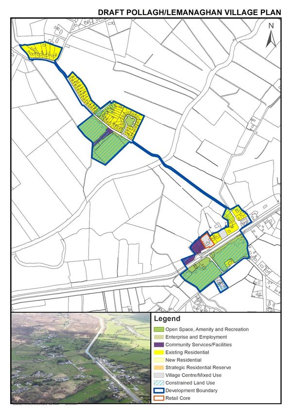
Offaly County Development Plan 2021-2027: Draft Stage
Village Plans

SO7 To encourage the re-development of the Opportunity Site which is a visually prominent site at
    the entry into the village. Development proposals on this site shall be in accordance with the
    requirements of Section 7.2.4 of Volume 1 of this County Development Plan.
SO8 To improve recreational facilities in the village such as the provision of an additional public
    amenity area.
Healthy Place Making and Infrastructure Objectives
SO9 To continue public realm improvements in the village including the undergrounding of cables;
    the upgrade and expansion of the public lighting and footpath network; and traffic calming
    measures.
SO10 To provide a pedestrian / cycling link between the village and the riverside amenity area and to
     improve and extend the river walk at this location, where feasible.
SO11 To investigate the feasibility of providing a footpath along the ‘loop road’ north of the village.
SO12 To protect the carrying capacity, efficiency and road safety of the R436 (Restricted Regional
     Route) through Ballycumber.

6
Offaly County Development Plan 2021-2027: Draft Stage
Village Plans

                                                        7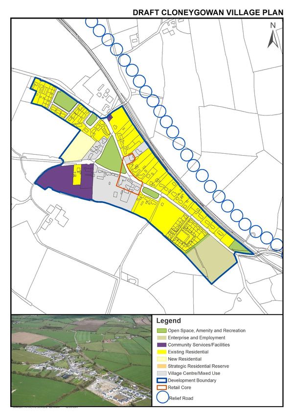
Offaly County Development Plan 2021-2027: Draft Stage
Village Plans

Belmont Village Plan
Settlement Description
Settlement Context: Belmont is located
approximately 5km west of Ferbane and
3.7km north of Cloghan. The village core is
centred on a crossroads with linear expansion
along the constituent roads. The River Brosna
and the Grand Canal are situated
approximately 1km south of the village. High
Street is located approximately 1.5km west of
the village, where the Roman Catholic Church,
Community Centre and National School are
located.
Population Census 2016: 200 (- 4.30 % since Census 2011)
Services and Facilities: Shop, 2 no. Pubs, Bring Centre, Belmont Firewood Factory, ESB Fisheries
Conservation. The village is served by the Local Link bus service.
Waste Water Treatment: Pumped to Ferbane Waste Water Treatment Plant
Water Supply: Moyclare Rural Water Supply Scheme
Broadband: High Speed Fibre Broadband
Settlement Objectives
Housing and Sustainable Communities Objectives
SO1 To ensure that future growth is balanced and sustainable and is appropriate to the scale, size
    and character of the existing village.
SO2 To encourage the consolidation of the village core particularly through the development of infill
    sites to create a compact, vibrant village.
Economic Development and Regeneration Objectives
SO3 To maintain and expand the existing service and employment provision in the village
    commensurate with the size of the village.
SO4 To promote physical and economic linkages between the village and the proposed Grand Canal
    Greenway and the River Brosna. This includes investigating the feasibility of providing a
    footpath / cycle link between the village and the Grand Canal, the River Brosna, Belmont Mills
    and Belmont House Stud.
Healthy Place Making and Infrastructure Objectives
SO5 To seek the improvement, consolidation and expansion of the public lighting and footpath
    network in the village, including a footpath / cycle link to High Street, where feasible.
SO6 To improve public amenities in the village, such as the provision of a communal open space area.
SO7 To further enhance the public realm in the village through the enhancement of existing public
    open spaces and the provision of a focal feature in the village.

8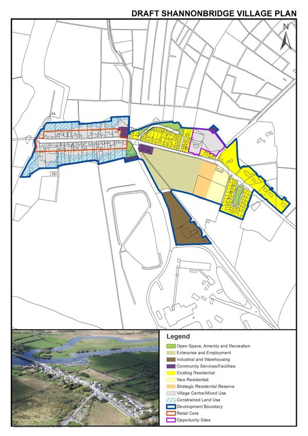
Offaly County Development Plan 2021-2027: Draft Stage
Village Plans

                                                        9
Offaly County Development Plan 2021-2027: Draft Stage
Village Plans

Bracknagh Village Plan
Settlement Description
Settlement Context: Bracknagh is located at the T‐
junction of the R442 and R419 roads. The River Figile
is located to the north, south and west of the village.
The settlement has expanded in a linear fashion along
the R419 where two housing estates by Offaly County
Council and Bord na Móna are located. Bracknagh is
located approximately 15km south of Edenderry, 6km
south of Clonbullogue, 8km northeast of
Portarlington, and 7km west of Rathangan, County
Kildare.
Population Census 2016: 212 (+ 1.4% since Census 2011)
Services and Facilities: Community Hall, Roman Catholic Church, National School, Shop / Post Office /
Pub, Bring Centre, Graveyard. The village is served by the Local Link bus service.
Waste Water Treatment: Bracknagh Waste Water Treatment Plant
Water Supply: Bracknagh Private Group Water Scheme
Broadband: High Speed Fibre Broadband
Settlement Objectives
Housing and Sustainable Communities Objectives
SO1 To ensure that future growth is balanced and sustainable and is appropriate to the scale, size
    and character of the existing village.
SO2 To promote the consolidation of the village by encouraging the development of infill sites to
    create a compact, vibrant village.
Economic Development and Regeneration Objectives
SO3 To retain and improve the retail offering in the village to serve the local population.
SO4 To facilitate the expansion of the employment and service base in the village.
SO5 To provide a village green / public amenity area in the centre of the village on land zoned ‘Open
    Space, Amenity & Recreation’.
Healthy Place Making and Infrastructure Objectives
SO6 To facilitate the provision of gateway features and natural edges on the key approaches into the
    village.
SO7 To examine the feasibility of providing a formal car parking / set-down area for the school.
SO8 To seek the upgrade and incremental expansion of the footpath and public lighting network in
    the village, where feasible.
SO9 To promote traffic calming and road safety measures in the village.

10
Offaly County Development Plan 2021-2027: Draft Stage
Village Plans
11Offaly County Development Plan 2021-2027: Draft Stage
Village Plans
Cloghan Village Plan
Settlement Description
Settlement Context: Cloghan is located at the
junction of the N62, R356 and R357 on the Birr
to Athlone road corridor. It is approximately
29km from Tullamore, 15km from Birr and
29km from Athlone. The village has an
interesting radial settlement pattern. The
original settlement is likely to have developed
as a small cluster at the junction with
subsequent expansion generally along the
constituent roads. Some of the more recent
housing development is quite suburban in style.
Due to its strategic location, the village experiences high volumes of passing traffic. This strategic
location should be exploited in the future development of the village.
Population Census 2016: 601 (-1.8 % since Census 2011)
Services and Facilities: Slí na Sláinte Walking Route, Roman Catholic Church, National School, Health
Centre, Bring Centre, GAA Grounds, Playground, Garda Station, Community Hall, Service Station / Post
Office, Butcher, Pub, Hair Salon, Crèche / Pre-School, Veterinary Clinic, Car Sales, Tractor Sales and a
number of other independent businesses. The village is served by the Local Link bus services and Bus
Eireann Route No. 72 (Limerick to Athlone).
Waste Water Treatment: Cloghan Waste Water Treatment Plant
Water Supply: Banagher Public Water Scheme
Broadband: High Speed Fibre Broadband
Settlement Objectives
Housing and Sustainable Communities Objectives
SO1 To ensure that future growth is balanced and sustainable and is appropriate to the scale, size
and character of the existing village.
SO2 To encourage the re-use of vacant buildings, the development of infill sites and the
refurbishment of derelict buildings to create a compact, vibrant village.
Economic Development and Regeneration Objectives
SO3 To facilitate the expansion of the employment and service base in the village. The re-use of
existing vacant buildings in the village centre will be particularly encouraged.
SO4 To exploit Cloghan’s strategic location on a key nodal point for employment generating uses.
Healthy Place Making and Infrastructure Objectives
SO5 To continue public realm improvements in the village including signage, public seating, hard and
soft landscaping and improvements to the road and footpath network.
SO6 To seek the upgrade, consolidation and incremental expansion of the public lighting and
footpath network in the village.
12Offaly County Development Plan 2021-2027: Draft Stage
Village Plans
SO7 To provide a bus shelter in the village.
SO8 To protect the carrying capacity, efficiency, road safety and amenity of the R356 and R357
(Restricted Regional Routes) and the N62 through Cloghan.
SO9 To upgrade the junction of the N62 and the R356.
SO10 To investigate the feasibility of providing a bypass for Cloghan, taking into account
environmental sensitivities as identified in the SEA Environmental Report and the policies and
objectives of this County Development Plan relating to sustainable mobility. The bypass route
on the map is indicative only. Any future proposals for roads corridors shall be consistent with
the other provisions contained in this County Development Plan including Section 8.5.4 Corridor
and Route Selection Process. To protect from development any reservation bands / corridors
for this bypass so as to avoid compromising the construction of the road.
SO11 To protect groundwater resources within the Source Protection Zone.
13Offaly County Development Plan 2021-2027: Draft Stage Village Plans 14
Offaly County Development Plan 2021-2027: Draft Stage
Village Plans

Clonbullogue Village Plan
Settlement Description
Settlement Context: Clonbullogue is an attractive
settlement located around the junction of the R401
and R442 roads, adjoining the Figile River. The village
is situated approximately 7km south of Edenderry,
10km northeast of Portarlington and 5km northwest
of Rathangan. The area around the triangular village
green has retained its character as a traditional‐style
village centre. Subsequent expansion has primarily
occurred on a north-south axis along the R401. The
village is affected by flood zones.
Population Census 2016: 439 (+ 4 % since Census
2011)
Services and Facilities: Roman Catholic Church, National School, Community Hall, Tidy Towns /
Community Local Employment Centre, GAA Grounds, Takeaway, Pub, Shop / Post Office, Health Centre
/ Community Play School. The Bring Centre is outside the settlement boundary. The Slí na Slainte
walking route is located in the village.
Waste Water Treatment: Clonbullogue Waste Water Treatment Plant
Water Supply: Clonbullogue Public Water Scheme
Broadband: High Speed Fibre Broadband
Settlement Objectives
Housing and Sustainable Communities Objectives
SO1 To ensure that future growth is balanced and sustainable and is appropriate to the scale, size
    and character of the existing village.
SO2 To require new development to take cognisance of and to reinforce the existing rural character
    of the village in terms of scale, layout, detailed design and landscaping.
SO3 To encourage the development of infill sites to create a compact, vibrant village.
SO4 Constrained Land Use zoning shall be developed in accordance with Section 12.6, Objective
    LUZO-14 in Volume 1 of this County Development Plan.
Economic Development and Regeneration Objectives
SO5 To facilitate the expansion of the employment and service base in the village.
SO6 To promote Clonbullogue as a destination on the proposed ‘Landscapes of Power’ cycling route
    contained in Figure 6.14 of Volume 1 of this County Development Plan and to encourage uses
    and development that achieve this objective.
Healthy Place Making and Infrastructure Objectives
SO7 To seek improvements to the public realm including undergrounding of cables; upgrading of the
    existing footpath and public lighting network; and improvements to the village green.

                                                                                               15
Offaly County Development Plan 2021-2027: Draft Stage
Village Plans
SO8 To improve pedestrian linkages in the village including investigating pedestrian linkages to Figile
Manor and the Sli na Slainte walking route over the Figile River.
SO9 To protect groundwater resources within the Source Protection Zone.
16Offaly County Development Plan 2021-2027: Draft Stage
Village Plans
17Offaly County Development Plan 2021-2027: Draft Stage
Village Plans
Cloneygowan Village Plan
Settlement Description
Settlement Context: Cloneygowan is located on the
R420 approximately 19km southeast of Tullamore
and 6km north of Portarlington. The Dublin-Galway
railway line lies to the north of the village, which has
acted as a development constraint and has resulted
in a linear settlement on an east-west axis with the
village core centred around the fairgreen.
Population Census 2016: 198 (+ 4.2% since Census
2011)
Services and Facilities: National School, Community Hall, Shop, Pub, Health Centre, Playschool, Bring
Centre
Waste Water Treatment: Cloneygowan Waste Water Treatment Plant
Water Supply: Killeigh / Cloneygowan Private Group Water Scheme
Broadband: High Speed Fibre Broadband
Settlement Objectives
Housing and Sustainable Communities Objectives
SO1 To ensure that future growth is balanced and sustainable and is appropriate to the scale, size
and character of the existing village.
SO2 To foster the creation of a more consolidated and coherent settlement to reinforce a sense of
place, with adequate critical mass to maintain/improve local service provision.
SO3 To facilitate the completion of unfinished developments in the village.
Economic Development and Regeneration Objectives
SO4 To facilitate the expansion of the employment and service base in the village. The re-use of
existing vacant buildings in the village centre will be particularly encouraged.
Healthy Place Making and Infrastructure Objectives
SO5 To provide public realm improvements in the village including signage, public seating, traffic
calming measures, improvements to the village green and upgrading of the existing footpath
and public lighting network.
SO6 To improve public amenities / recreational facilities in the village. The village fairgreen has the
potential to accommodate a range of recreational uses for the benefit of the local community.
SO7 To seek the consolidation and expansion of the public lighting and footpath network in the
village.
SO8 To protect groundwater resources within the Source Protection Zone.
SO9 To protect from development, the proposed bypass reservation band / corridor so as to avoid
compromising the construction of the road.
18Offaly County Development Plan 2021-2027: Draft Stage
Village Plans
19Offaly County Development Plan 2021-2027: Draft Stage
Village Plans
Coolderry Village Plan
Settlement Description
Settlement Context: Coolderry is a small village
nestled in the foothills of the Slieve Bloom
Mountains. It is located approximately 8km
north of Roscrea and 11km south of Birr, on a
local road. There are a number of community
facilities in the village, however the village lacks
a retail or commercial core.
Population: 85 (estimate)
Services and Facilities: National School, Roman
Catholic Church, Community Hall, GAA Grounds,
Bring Centre, Car Park. The village is served by the Local Link bus service.
Waste Water Treatment: Coolderry Waste Water Treatment Plant
Water Supply: Coolderry Public Water Supply Scheme
Broadband: State Intervention Area under the National Broadband Plan
Settlement Objectives
Housing and Sustainable Communities Objectives
SO1 To ensure that future growth is balanced and sustainable and is appropriate to the scale, size
and character of the existing village.
Economic Development and Regeneration Objectives
SO2 To establish a retail core in the village by encouraging the development of small-scale retail /
commercial services to serve the local population.
SO3 To investigate the feasibility of providing a playground in the village.
Healthy Place Making and Infrastructure Objectives
SO4 To seek the consolidation, expansion and upgrade of the footpath network in the village.
SO5 To promote pollinator projects and pollinator friendly planting in the village.
SO6 To improve the visual interface of the wastewater treatment plant.
SO7 To protect groundwater resources within the Source Protection Zone.
20Offaly County Development Plan 2021-2027: Draft Stage
Village Plans
21Offaly County Development Plan 2021-2027: Draft Stage
Village Plans
Geashill Village Plan
Settlement Description
Settlement Context: Geashill is an attractive,
planned village located at the crossroads formed
by the R420 (Tullamore– Portarlington road) and
the Ballinagar‐Kilcavan road. It is located
approximately 12km east of Tullamore and 14km
west of Portarlington. The village is centred
around a village green and has a strong presence
of mature trees. It is the collection of individual
elements of architecture, open space and trees
that together give Geashill its character. The
village centre is designated as an Architectural
Conservation Area (ACA) due to its distinctive
architectural, historical, archaeological and social interest. The village is largely residential. There is
an absence of shop fronts in the streetscape which might be expected in a settlement of this size.
Population Census 2016: 395 (+ 5.30 % since Census 2011)
Services and Facilities: National School, Church of Ireland Church, Community Hall, Service Station and
2 no. pubs. The GAA grounds are located outside the settlement and connected to the village by a
walking and cycling track. The Glebe Walk is a walking loop in the village. Planning permission has
been granted for a playground in the village (Ref: 18379).
Waste Water Treatment: Geashill Waste Water Treatment Plant
Water Supply: Geashill Public Water Scheme
Broadband: High Speed Fibre Broadband
Settlement Objectives
Housing and Sustainable Communities Objectives
SO1 To ensure that future growth is balanced and sustainable and is appropriate to the scale, size
and character of the existing village. New development in the village shall take its cue from both
the architecture and the urban design of Geashill.
SO2 To make provision for the sustainable growth of the village which will support existing services
and encourage the further expansion of the service base, whilst retaining its distinctive
character.
SO3 To support the re-use of vacant and derelict buildings; the development of infill sites; and the
completion of the unfinished housing estate in the village to achieve a vibrant, compact village.
SO4 To preserve and protect the ACA in the village and to ensure that any new development within
or contiguous to the ACA is sympathetic to the special character of the ACA and that the design
is appropriate in terms of scale, height, plot density, layout, materials and finishes.
Economic Development and Regeneration Objectives
SO5 To encourage the further development of retail and commercial services in the village.
22Offaly County Development Plan 2021-2027: Draft Stage
Village Plans
SO6 To promote Geashill as a destination on the proposed ‘Landscapes of Power’ cycling route
contained in Figure 6.14 of Volume 1 of this County Development Plan and to encourage uses
and development that achieve this objective.
Healthy Place Making and Infrastructure Objectives
SO7 To support the implementation of the ‘Geashill Public Realm Study 2012’.
SO8 To preserve and protect existing mature trees and stone walls which contribute to the
distinctive character of the village.
SO9 To support the provision of an amenity area / playground in the western part of the village and
points of interest along the Glebe Walk.
SO10 To continue to promote pollination in the village in the interests of climate adaption.
SO11 To investigate the feasibility of providing a bypass for Geashill, taking into account
environmental sensitivities as identified in the SEA Environmental Report and the policies and
objectives of this County Development Plan relating to sustainable mobility. Any future
proposals for roads corridors shall be consistent with the other provisions contained in this
County Development Plan including Section 8.5.4 Corridor and Route Selection Process. To
protect from development any reservation bands / corridors for this bypass so as to avoid
compromising the construction of the road.
SO12 To protect the carrying capacity, efficiency and road safety of the R420 (Restricted Regional
Route) through Geashill.
SO13 To seek the consolidation, improvement and expansion of the existing public lighting and
footpath network.
SO14 To protect groundwater resources within the Source Protection Zone.
23Offaly County Development Plan 2021-2027: Draft Stage Village Plans 24
Offaly County Development Plan 2021-2027: Draft Stage
Village Plans

Killeigh Village Plan
Settlement Description
Settlement Context: Killiegh is an attractive village
situated at the crossroads of the N80 and local roads.
It is strategically positioned approximately 8km from
Tullamore and 26km from Portlaoise. The village is
centred around a village green at the crossroads and
has generally expanded in a linear fashion along the
constituent roads. The village is affected by a flood
zone which generally follows the watercourse
running through the village. There are also a number
of archaeological features in the village.
Population Census 2016: 212 (+ 7.60 % since Census
2011)
Services and Facilities: GAA Grounds, National School, Roman Catholic Church, Church of Ireland
Church, Shop, Pub, Hairdresser and Beauty Salon, Childcare Facilities, Car Sales. The Seven Blessed
Wells of Killeigh walking route is located in the village. Killeigh is served by Bus Eireann’s No. 73 bus
route from Waterford to Longford via Athlone.
Waste Water Treatment: Killeigh Waste Water Treatment Plant
Water Supply: Killiegh / Cloneygowan Private Group Water Scheme
Broadband: High Speed Fibre Broadband
Settlement Objectives
Housing and Sustainable Communities Objectives
SO1 To ensure that future growth is balanced and sustainable and is appropriate to the scale, size
    and character of the existing village.
SO2 There are two Opportunity Sites identified in the village which have the potential to consolidate
    the village core and provide for compact urban growth. Development proposals on these sites
    shall be in accordance with the requirements of Section 7.2.4 of Volume 1 of this County
    Development Plan.
SO3 Constrained Land Use zoning shall be developed in accordance with Section 12.6, Objective
    LUZO-14 in Volume 1 of this County Development Plan.
Economic Development and Regeneration Objectives
SO4 To maintain and expand the existing service provision in the village commensurate with
    population growth.
SO5 To support the re-development of the Marca Hall as a community centre.
Healthy Place Making and Infrastructure Objectives
SO6 To seek the upgrade, consolidation and expansion of the public lighting and footpath network
    in the village.

                                                                                                      25
Offaly County Development Plan 2021-2027: Draft Stage
Village Plans
SO7 To improve public amenities / recreational facilities in the village, including exploring the
possibility of extending The Seven Blessed Wells of Killeigh walking route northwards along the
river/stream.
SO8 To protect the carrying capacity, efficiency and road safety of the N80 through Killeigh.
SO9 To promote traffic calming measures and road safety in the village including investigating the
feasibility of providing a pedestrian crossing at the school.
SO10 To protect the Irish Water Eastern and Midlands Water Supply Project pipeline corridor from
inappropriate development that would prejudice the delivery of the project.
SO11 To investigate the feasibility of providing a bypass for Killeigh, taking into account environmental
sensitivities as identified in the SEA Environmental Report and the policies and objectives of this
County Development Plan relating to sustainable mobility. Any future proposals for roads
corridors shall be consistent with the other provisions contained in this County Development
Plan including Section 8.5.4 Corridor and Route Selection Process. To protect from development
any reservation bands / corridors for this bypass so as to avoid compromising the construction
of the road.
26Offaly County Development Plan 2021-2027: Draft Stage
Village Plans
27Offaly County Development Plan 2021-2027: Draft Stage
Village Plans
Kinnitty Village Plan
Settlement Description
Settlement Context: Kinnitty is an attractive
village located at the foothills of the Slieve
Bloom Mountains, at the confluence of the
R421, R440 and three local roads. It is
approximately 25km from Tullamore and 13km
from Birr. The village is located in an Area of
High Amenity and is characterised by a
vernacular core, centred around the village
green with more recent ribbon development
along the constituent roads. Kinnitty is
strategically positioned to act as a tourism hub
for exploring the Slieve Bloom Mountains.
Population Census 2016: 381 (+ 6.10 % since Census 2011)
Services and Facilities: National School, Health Centre, Community Centre, Bring Centre, Playground,
Garda Station, Roman Catholic Church, Church of Ireland Church, Drapery, 2 no. Pubs, 2 no. Shops,
Post Office, Guesthouse and Glamping and 2 no. Bed & Breakfasts. The GAA grounds are located
outside the settlement with a footpath linking to the village. The village is served by the Local Link bus
service.
Waste Water Treatment: Kinnitty Waste Water Treatment Plant
Water Supply: Kinnitty Public Water Scheme
Broadband: High Speed Fibre Broadband
Settlement Objectives
Housing and Sustainable Communities Objectives
SO1 To ensure that future growth is balanced and sustainable and is appropriate to the scale, size
and character of the existing village.
SO2 To encourage the re-use of vacant dwellings and commercial premises and the development of
infill sites to create a compact, vibrant village.
Economic Development and Regeneration Objectives
SO3 To support developments that will establish Kinnitty as a cycling and outdoor recreation hub for
the Slieve Bloom Mountains and as a destination on the proposed ‘Lough Boora Parklands and
Drinagh Wetlands’ cycling route contained in Figure 6.14 of Volume 1 of this County
Development Plan.
SO4 To grow a visitor economy in the village by encouraging tourism-related uses, activities and
amenities that will contribute to the Slieve Bloom Mountains tourism product.
SO5 To encourage the further development of retail and commercial services in the village core. The
redevelopment of existing unused or derelict structures for commercial or residential purposes
will be particularly encouraged.
28Offaly County Development Plan 2021-2027: Draft Stage
Village Plans
Healthy Place Making and Infrastructure Objectives
SO6 To continue to improve walking and cycling linkages to the Slieve Bloom Mountain Bike Trail and
Mountain Walks.
SO7 To create a sense of arrival at key approaches and arrival points in the village through
improvements to the public realm.
SO8 New development will be required to protect the setting of archaeological features, Protected
Structures and the Slieve Bloom Mountains.
SO9 To protect the carrying capacity, efficiency, road safety and amenity of the R421 and R440
(Restricted Regional Routes) through Kinnitty.
29Offaly County Development Plan 2021-2027: Draft Stage Village Plans 30
Offaly County Development Plan 2021-2027: Draft Stage
Village Plans

Moneygall Village Plan
Settlement Description
Settlement Context: Located close to the most
southern point in County Offaly, Moneygall is a
village on the old N7 Dublin‐Limerick Road, now
Regional Road R445. The village has essentially been
bypassed by the M7 motorway which lies to the
north of the village. The village has a long main
street running for approximately 450m. There are a
number of vacant buildings in the village,
concentrated in the village core. There have been
significant improvements to the community facilities
available in the village in recent years with the development of Moneygall FC Grounds, a Multi-Use
Games Area, Playground and Community Garden. The GAA grounds and Barack Obama Plaza are
located on the outskirts of the village in County Tipperary.
Population Census 2016: 313 (+ 1 % since Census 2011)
Services and Facilities: Health Centre, Community Garden, Multi-Use Games Area, Playground,
Moneygall FC Grounds, Roman Catholic Church, National School, Community Hall, Bring Centre, Garda
Station, 2 no. Pubs, Car Sales, Hair Salon, Funeral Directors. The trailhead for the ‘Rock of Loyer Loop’
walking route is located in the village. The village is served by the Local Link bus service.
Waste Water Treatment: Moneygall Waste Water Treatment Plant
Water Supply: Moneygall Public Water Scheme
Broadband: High Speed Fibre Broadband
Settlement Objectives
Housing and Sustainable Communities Objectives
SO1 To ensure that future growth is balanced and sustainable and is appropriate to the scale, size
    and character of the existing village.
SO2 To encourage the re-use of vacant buildings, the development of infill sites and the completion
    of unfinished developments to create a compact, vibrant village.
SO3 Constrained Land Use zoning shall be developed in accordance with Section 12.6, Objective
    LUZO-14 in Volume 1 of this County Development Plan.
Economic Development and Regeneration Objectives
SO4 To facilitate the expansion of the employment, retail and service base in the village. The re-use
    of existing vacant buildings in the village centre will be particularly encouraged.
SO5 To actively promote Moneygall as a destination for new business, for example in the distribution
    and warehousing sector, given its strategic location on the M7 motorway.
SO6 To grow a visitor economy in the village by encouraging tourism-related uses, activities and
    amenities.

                                                                                                      31
Offaly County Development Plan 2021-2027: Draft Stage
Village Plans
SO7 To capitalise on further tourist related opportunities for the village through the synergy with
Barrack Obama Plaza, and to facilitate and develop uses, activities and public infrastructure to
support the Village becoming a ‘stop-off’ destination for visitors to the midlands and south
including visitors or tours on ‘Ireland’s Ancient East’ trail.
SO8 To support the local community in advancing the ‘Green Moneygall’ project.
Healthy Place Making and Infrastructure Objectives
SO9 To maintain the existing community facilities in Moneygall and to support the provision of
additional facilities including a community gym / cafe / meeting place.
SO10 To promote public realm improvements in the village core including signage, pollination areas,
hard and soft landscaping, undergrounding of overhead wires and improvements to the road,
footpath and public lighting network.
SO11 To initiate a surface water drainage scheme in the village.
SO12 To seek the incremental expansion of the public lighting and footpath network in the village.
SO13 To protect the carrying capacity, efficiency and road safety of the R445 (Restricted Regional
Route) through Moneygall.
32Offaly County Development Plan 2021-2027: Draft Stage
Village Plans
33Offaly County Development Plan 2021-2027: Draft Stage
Village Plans
Mountbolus Village Plan
Settlement Description
Settlement Context: Mountbolus is a small village
located between Kilcormac and Tullamore, south of
the N52, with views of the Slieve Bloom mountains
southwards. It is approximately 15km from
Tullamore and 8km from Kilcormac. The main
street, L‐2014, lies on a gradient falling from east to
west. There is a village green in the centre of the
village at the junction of the L‐6026 and the L‐2014.
There are a number of vacant commercial buildings
along the Main Street.
Population Census 2016: 129 (estimate)
Services and Facilities: Roman Catholic Church, Community Hall, GAA Grounds, National School, Bring
Centre, Pub and Acquired Brain Injury Ireland. The village is served by the Local Link bus service.
Waste Water Treatment: Mountbolus Waste Water Treatment Plant
Water Supply: Mountbolus Public Water Scheme
Broadband: High Speed Fibre Broadband
Settlement Objectives
Housing and Sustainable Communities Objectives
SO1 To ensure that future growth is balanced and sustainable and is appropriate to the scale, size
and character of the existing village.
SO2 To require new development to take cognisance of and to reinforce the existing rural character
of the village in terms of scale, layout, detailed design and landscaping.
Economic Development and Regeneration Objectives
SO3 To encourage the further development of retail and commercial services in the village core. The
redevelopment of existing vacant or derelict buildings for commercial or residential purposes
will be particularly encouraged.
SO4 To improve public amenities in the village. An area around the Community Centre is set aside
as a public amenity area for the benefit of the local community.
Healthy Place Making and Infrastructure Objectives
SO5 To support improvements to the public realm including landscaping and addressing the visual
clutter along Main Street caused by power, lighting and hanging basket poles.
SO6 To seek the upgrade, consolidation and expansion of the public lighting and footpath network
in the village and the provision of cycle lanes where feasible.
SO7 To protect groundwater resources within the Source Protection Zone.
34Offaly County Development Plan 2021-2027: Draft Stage
Village Plans
35Offaly County Development Plan 2021-2027: Draft Stage
Village Plans
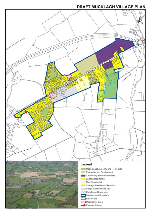
Mucklagh Village Plan
Settlement Description
Settlement Context: Mucklagh is located
alongside the old N52, now the L-2030-1,
approximately 5km southwest of Tullamore.
The original form reflected some sporadic
roadside development i.e. houses, farms etc.
but due to its proximity to Tullamore and the
demand it generated, the area was subject to
linear development along the old N52.
Measuring approximately 1.6km in length along
the now local road, the settlement at Mucklagh
is extremely long with very little depth and with
no real centre or core area. The village’s dispersed linear form should be consolidated in future growth
to bring some form to the settlement and to reinforce the sense of place.
Population Census 2016: 826 (+ 2 % since Census 2011)
Services and Facilities: Roman Catholic Church, Graveyard, Community Centre, GAA Grounds, Nursing
Home, National School, 2 no. Funeral Directors, Hair Salon, Pub, Shop, Pre-school and After-School
Waste Water Treatment: Mucklagh Waste Water Treatment Plant
Water Supply: Rahan – Agall/Hollimshill Public Water Scheme
Broadband: High Speed Fibre Broadband
Settlement Objectives
Housing and Sustainable Communities Objectives
SO1 To ensure that future growth is balanced and sustainable and is appropriate to the scale, size
and character of the existing village.
SO2 To foster the creation of a more consolidated and coherent settlement to reinforce a sense of
place.
SO3 To encourage the development of infill sites and re-use of vacant buildings to create a compact,
vibrant village.
SO4 An Opportunity Site is identified in the village which has the potential to consolidate the village
with a high quality scheme. Development proposals on this site shall be in accordance with the
requirements of Section 7.2.4 of Volume 1 of this County Development Plan.
SO5 Constrained Land Use zoning shall be developed in accordance with Section 12.6, Objective
LUZO-14 in Volume 1 of this County Development Plan.
Economic Development and Regeneration Objectives
SO6 To encourage the further development of retail and commercial services in the village core to
expand the local service and employment base.
SO7 To enhance the public realm, to define the village core and to create a sense of place.
36Offaly County Development Plan 2021-2027: Draft Stage
Village Plans
Healthy Place Making and Infrastructure Objectives
SO8 To improve public amenities / recreational facilities in the village.
SO9 To seek the upgrade and incremental expansion of the public lighting and footpath network in
the village.
SO10 To investigate the feasibility of providing a cycle lane and public lighting linking Mucklagh to
Charleville Road in Tullamore.
SO11 To promote traffic calming measures and road safety in the village.
37Offaly County Development Plan 2021-2027: Draft Stage Village Plans 38
Offaly County Development Plan 2021-2027: Draft Stage
Village Plans

Pollagh / Lemanaghan Village Plan
Settlement Description

Settlement Context:
Pollagh is a dispersed linear settlement located
on the Grand Canal and north of the Lough
Boora Discovery Park in a remote part of the
county. It is 14km (via tow path) from
Tullamore or 22km by road. Pollagh and
Lemanaghan can be described as a bi‐nodal
settlement, as they function as one place.

Population Census 2016: 227 (- 9.6 % since Census 2011)
Services and Facilities: Community Shop and Youth Space, Men’s Shed, Shop, Pub, National School,
Roman Catholic Church, GAA Grounds, Community Centre, Bring Centre, Soccer Pitch. The village is
served by the Local Link bus service.
Waste Water Treatment: Lemanaghan Waste Water Treatment Plant
Water Supply: Rahan-Agall/Hollimshill PWS
Broadband: High Speed Fibre Broadband
Settlement Objectives
Housing and Sustainable Communities Objectives
SO1 To ensure that future growth is balanced and sustainable and is appropriate to the scale, size
    and character of the existing village.
SO2 Constrained Land Use zoning shall be developed in accordance with Section 12.6, Objective
    LUZO-14 in Volume 1 of this County Development Plan.
Economic Development and Regeneration Objectives
SO3 To maintain and expand the local service provision in the village.
SO4 To promote Pollagh-Lemanaghan as a destination on the Grand Canal Greenway and the
    proposed ‘Shannon Monastic Greenway’ and ‘Lough Boora Parklands and Drinagh Wetlands’
    cycling routes contained in Figure 6.14 of Volume 1 of this County Development Plan and to
    support uses, infrastructure and development that achieve this objective.
Healthy Place Making and Infrastructure Objectives
SO5 To improve pedestrian facilities in the village including footpath links between the Community
    Shop and Bridge and between Pollagh and Lemanaghan.
SO6 To improve wayfinding in the village by providing road safety, directional and tourism signage.
SO7 To enhance biodiversity in the village.

                                                                                                 39
Offaly County Development Plan 2021-2027: Draft Stage Village Plans 40
Offaly County Development Plan 2021-2027: Draft Stage
Village Plans

Rhode Village Plan
Settlement Description
Settlement Context: Rhode village is situated in the
north‐eastern corner of County Offaly at the junction
of the R400 and R441. Two prominent hills are
located close to the village, namely Croghan Hill and
Clonin Hill. Rhode is situated approximately 12km
west of Edenderry and approximately 8km south-
east of the M6 motorway. The village is likely to have
evolved from a small cluster at the crossroads
demonstrated by its vernacular style. Subsequent
expansion traditionally has taken the form of linear
development along the constituent roads including
an ESB and local authority housing development. More recent residential development in the north-
west quadrant of the village has assisted in consolidating the village.
Rhode Energy Park is strategically located on the outskirts of Rhode, just 7km from the M6 Dublin to
Galway motorway. The business park has been established on the site of a former ESB Power Station
and occupies approximately 5.3ha with 13 serviced sites. The area has a strong heritage in energy
production, and coupled with the strategic location, the park is considered suitable for Green Energy
as well as other complementary uses such as Green Enterprise, Food Processing, Manufacturing,
Logistics, Engineering and Research and Development (R&D).
Population Census 2016: 811 (+ 4.2 % since Census 2011)
Services and Facilities: Roman Catholic Church, Graveyard, Community Centre, Community
Employment Scheme, Rhode Community Pre-School, Health Centre, The Village Park, 3 no. Pubs, Shop
and Post Office, Florist, Service Station, Pharmacy, Hair Salons and Take Aways. The National School
and GAA Grounds are located outside the settlement boundary. The village is served by the Local Link
Bus Service and the Business Eireann No. 120 route (Dublin to Tullamore).
Waste Water Treatment: Rhode Waste Water Treatment Plant
Water Supply: Rhode Public Water Scheme
Broadband: High Speed Fibre Broadband
Settlement Objectives
Housing and Sustainable Communities Objectives
SO1 To ensure that future growth is balanced and sustainable and is appropriate to the scale, size
    and character of the existing village.
SO2 To encourage the development of infill sites to create a compact, vibrant village.
SO3 An Opportunity Site is identified in the village which has the potential to consolidate the village
    core at a prominent corner site. Development proposals on this site shall be in accordance with
    the requirements of Section 7.2.4 of Volume 1 of this County Development Plan.

                                                                                                    41
Offaly County Development Plan 2021-2027: Draft Stage
Village Plans
Economic Development and Regeneration Objectives
SO4 To facilitate the expansion of the employment and service base in the village.
SO5 To actively promote Rhode as a destination for new employment opportunities, given its
strategic location proximate to the M6 motorway.
SO6 To support and promote the development of Rhode Green Energy Park for Green Energy as well
as other complementary uses such as Green Enterprise, Food Processing, Manufacturing,
Logistics, Engineering and Research and Development (R&D).
Healthy Place Making and Infrastructure Objectives
SO7 To seek the upgrade, consolidation and expansion of the footpath network in the village.
SO8 To investigate the feasibility of providing a footpath to the GAA grounds in Killure.
SO9 To protect groundwater resources within the Source Protection Zone.
SO10 To protect the carrying capacity, efficiency and road safety of the R400 (Restricted Regional
Route) through Rhode.
42Offaly County Development Plan 2021-2027: Draft Stage
Village Plans
43Offaly County Development Plan 2021-2027: Draft Stage
Village Plans
Riverstown Village Plan
Settlement Description
Settlement Context: Riverstown is a
village arranged around the crossing point
of the N52 over the Little Brosna River,
2km southwest of Birr Town. The Little
Brosna River marks the county boundary
between County Tipperary and County
Offaly and the village is within the
administrative area of both Councils. This
Village Plan pertains to that portion of the
village within County Offaly, however the
bulk of the settlement and village core is
located in County Tipperary. It is
recognised that future growth (including local service provision) will predominantly occur within the
portion of the village located in County Tipperary. Riverstown acts as a gateway to County Offaly and
is characterised by stone walls, mature trees and hedgerows, the Little Brosna River and a five-arch
stone bridge.
Population: 39 (estimate)
Services and Facilities: Bar / Restaurant. The National School is located in County Tipperary
Waste Water Treatment: Pumping Station in County Tipperary and treated in Birr Waste Water
Treatment Plant
Water Supply: Ballindarra Public Group Water Scheme
Broadband: High Speed Fibre Broadband
Settlement Objectives
Housing and Sustainable Communities Objectives
SO1 To ensure that future growth is balanced and sustainable and is appropriate to the scale, size
and character of the existing village.
SO2 To require new development to take cognisance of and to reinforce the existing rural character
of the village in terms of scale, layout, detailed design and landscaping.
SO3 To maintain a development buffer between Birr and Riverstown.
SO4 Constrained Land Use zoning shall be developed in accordance with Section 12.6, Objective
LUZO-14 in Volume 1 of this County Development Plan.
Economic Development and Regeneration Objectives
SO5 To encourage local service provision in the village centre to serve the local population and
commensurate with the size of the village.
SO6 To support the examination of the proposed Birr to Portumna Greenway.
44Offaly County Development Plan 2021-2027: Draft Stage
Village Plans
Healthy Place Making and Infrastructure Objectives
SO7 To facilitate the provision of a suitable gateway feature to signal the entry into County Offaly.
SO8 To support the extension of the existing footpath and public lighting network, including a
continuous footpath link to Birr, where feasible.
SO9 To protect the amenity value and rural character of the village, including the Little Brosna River,
mature trees, hedgerows, stone boundary walls and archaeological features.
SO10 To protect the carrying capacity, efficiency and road safety of the N52 through Riverstown.
45Offaly County Development Plan 2021-2027: Draft Stage Village Plans 46
Offaly County Development Plan 2021-2027: Draft Stage
Village Plans

Shannon Harbour Village Plan
Settlement Description
Settlement Context: Shannon Harbour is located at the
junction of the Grand Canal and the River Shannon in
West Offaly. Environmental and flood designations
apply to the village and restrict its development
potential. Shannon Harbour is a node on the county’s
greenway network and tourism is an important
contributor to the local economy.
Population: 52 (estimate)
Services and Facilities: 2 no. Pubs, Community Centre and Public Facilities, Bring Centre, Playground,
Waterways Ireland, Bed & Breakfast. The village is served by the Local Link bus service.
Waste Water Treatment: Shannon Harbour Waste Water Treatment Plant
Water Supply: Moyclare Rural Water Supply Scheme
Broadband: State Intervention Area under the National Broadband Plan. ‘Visit Offaly Free Wi-Fi’ is
available
Settlement Objectives
Housing and Sustainable Communities Objectives
SO1 To ensure that future growth is balanced and sustainable and is appropriate to the scale, size
    and character of the existing village.
SO2 To require new development to have regard to the rural character and environmental sensitivity
    of the village and to avoid adverse impacts on the integrity of the Natura 2000 network.
SO3 Constrained Land Use zoning shall be developed in accordance with Section 12.6, Objective
    LUZO-14 in Volume 1 of this County Development Plan.
Economic Development and Regeneration Objectives
SO4 To promote Shannon Harbour as a destination along the Grand Canal Greenway and to support
    tourism-related uses.
SO5 The former Grand Canal Hotel is identified as an Opportunity Site in the village. This building
    occupies a prominent position in the village and is in an advanced state of dis-repair. The Council
    supports the sensitive restoration of this Protected Structure which would positively contribute
    to the overall aesthetics of the village and the Shannon Harbour tourism product. Development
    proposals on this site shall be in accordance with the requirements of Section 7.4.5 of Volume
    1 of this County Development Plan.
Healthy Place Making and Infrastructure Objectives
SO6 To support the delivery of the proposed greenway network through Shannon Harbour linking to
    Banagher.
SO7 To protect the amenity value of the Grand Canal and to work with Waterways Ireland and
    private boat owners to improve the appearance of moored boats along the canal.

                                                                                                    47
Offaly County Development Plan 2021-2027: Draft Stage Village Plans 48
Offaly County Development Plan 2021-2027: Draft Stage
Village Plans

Shannonbridge Village Plan
Settlement Description
Settlement Context: Shannonbridge is
situated at a bridging point of the River
Shannon in West Offaly on the border with
County Roscommon. It is approximately
10km south of Clonmacnoise at the
junction of the R357 and R444. The
settlement is predominately linear in
fashion and characterised by low density
development and a traditional main street.
Environmental and flood designations
restrict development to the north and
south along the River Shannon.
Historically, West Offaly Power has been a key employer in the area. Given its location on the River
Shannon and proximity to Clonmacnoise, tourism also makes a significant contribution to the local
economy. This tourism potential can be further developed by promoting Shannonbridge as a tourism
hub for exploring Clonmacnoise and a node on the county’s proposed greenway network.
Population Census 2016: 175 (- 15% since Census 2011)
Services and Facilities: Roman Catholic Church, Church of Ireland Church, Tourist Office, Playground,
Bring Centre, Health Centre, Post Office, 2 no. Shops, 3 no. Pubs, 2 no. Restaurants and 2 no. Bed &
Breakfasts, Public Facilities. The National School and GAA Grounds are located outside the settlement
boundary. The village is served by the Local Link bus service.
Waste Water Treatment: Shannonbridge Waste Water Treatment Plant
Water Supply: Moyclare Rural Water Supply Scheme
Broadband: High Speed Fibre Broadband
Settlement Objectives
Housing and Sustainable Communities Objectives
SO1 To ensure that future growth is balanced and sustainable and is appropriate to the scale, size
    and character of the existing village.
SO2 To encourage the re-use of vacant dwellings and commercial premises to sustain life in the
    village centre and to provide for compact growth.
SO3 To require new development to have regard to the rural character and environmental sensitivity
    of the village and to avoid adverse impacts on the integrity of the Natura 2000 network.
SO4 Constrained Land Use zoning shall be developed in accordance with Section 12.6, Objective
    LUZO-14 in Volume 1 of this County Development Plan.
Economic Development and Regeneration Objectives
SO5 To explore the provision of a visitor centre in Shannonbridge for Clonmacnoise monastic site
    and the monastic heritage of the county.

                                                                                                  49
You can also read