Waikato Expressway Hamilton Section - Notice of Requirement to Alter the Designation Ruakura Interchange - Waka Kotahi NZ ...
←
→
Page content transcription
If your browser does not render page correctly, please read the page content below
Waikato Expressway
Hamilton Section
Notice of Requirement to Alter the
Designation
Ruakura Interchange
February 2014
Ruakura Interchange – Notice of Requirement                                                                   i

Contents
1       Introduction ....................................................................................................... 4
        1.1 Overview............................................................................................................................ 4
        1.2 New Zealand Transport Agency ........................................................................................ 4
        1.3 Roads of National Significance ......................................................................................... 4
        1.4 Waikato Expressway ......................................................................................................... 4
        1.5 Waikato Expressway – Hamilton Section......................................................................... 6
        1.6 Project Specific Objectives ................................................................................................ 7
        1.7 Ruakura Interchange – Proposed Alteration .................................................................... 7

2       Background ...................................................................................................... 10
        2.1 Existing Designations and Conditions ............................................................................ 10
        2.2 Alterations to the Designation ........................................................................................ 12
        2.3 Resource Consents .......................................................................................................... 12

3       Planning Context ...............................................................................................14
        3.1 Local Authority Boundary Changes ................................................................................ 14
        3.2 Ruakura Structure Plan .................................................................................................. 14
        3.3 Ruakura Development Private Plan Change................................................................... 15

4       Ruakura Interchange ........................................................................................16
        4.1 Form 18 ........................................................................................................................... 16
        4.2 Consideration of Alternatives ......................................................................................... 19
        4.3 Assessment of Environmental Effects ............................................................................ 19

5       Consultation..................................................................................................... 66
        5.1 Overview.......................................................................................................................... 66
        5.2 Ruakura Interchange Consultation................................................................................. 66
        5.3 Tangata Whenua Consultation ....................................................................................... 67
        5.4 Affected Landowner Consultation ..................................................................................68
        5.5 Ruakura Structure Plan and the Ruakura Development PPC Consultation................... 69
        5.6 Summary ......................................................................................................................... 69

6       Statutory Assessment ....................................................................................... 70
        6.1 Resource Management Act 1991 ..................................................................................... 70
        6.2 Part 2 ............................................................................................................................... 72
        6.3 National Environmental Standards ................................................................................ 74
        6.4 Other Regulations ........................................................................................................... 75
        6.5 Regional Policy and Plans ............................................................................................... 76
        6.6 Plans and Proposed Plans ............................................................................................... 79
        6.7 Other Plans...................................................................................................................... 83

7       Conclusion ....................................................................................................... 86

19 February 2014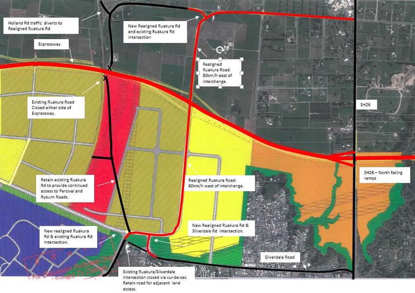
Ruakura Interchange – Notice of Requirement                    ii

Appendix A – Existing Conditions for the Hamilton Section of the Waikato Expressway
             Designation

Appendix B – Certificates of Title

Appendix C – Plans in Support of the Alteration to Designation

Appendix D – Network Connections Summary Report – March 2013

Appendix E – Traffic Assessment Results

19 February 2014
Ruakura Interchange – Notice of Requirement                 iii

Glossary of Terms:

 AEE           Assessment of Environmental Effects
 Agency        New Zealand Transport Agency
 CMP           Construction Management Plan
 GPS           Government Policy Statement on Land Transport Funding 2009/10 – 2018/19
 HCC           Hamilton City Council
 HCV           Heavy Commercial Vehicle
 HPA           Historic Places Act 1993
 LOS           Level of Service
 LTMA          Land Transport Management Act 2003
 NOR           Notice of Requirement
 NZHPT         New Zealand Historic Places Trust
 NZS           New Zealand Standard
 Opus          Opus International Consultants
 PIR           Project Investigation Report
 PPC           Private Plan Change
 Project       The Waikato Expressway-Hamilton Section
 PT            Public Transport
 PWRPS         Proposed Waikato Regional Policy Statement – also referred to as PRPS
 RLTS          Waikato Regional Land Transport Strategy 2007
 RMA           Resource Management Act 1991
 RoNS          Roads of National Significance
 RPS           Waikato Regional Policy Statement
 SARA          Scheme Assessment Report Addendum
 SH1           State Highway 1
 TDM           Travel Demand Management
 TGH           Tainui Group Holdings Ltd
 TWEAR         Tangata Whenua Effects Assessment Report
 TWWG          Tangata Whenua Working Group
 vpd           Vehicles per day
 WDC           Waikato District Council
 WRC           Waikato Regional Council
 WRP           Waikato Regional Plan
 WRPS          Waikato Regional Policy Statement (Operative) – also referred to as RPS
 WRTM          Waikato Regional Transportation Model

19 February 2014
Ruakura Interchange – Notice of Requirement 4
1 Introduction
1.1 Overview
The New Zealand Transport Agency (the Agency) has prepared this Notice of Requirement (NOR) to
alter the designation for the Hamilton Section of the Waikato Expressway (Hamilton Section) in
order to accommodate an interchange at Ruakura, remove the currently designated two north facing
ramps at SH26/Morrinsville Road interchange, and the relocation of Ruakura Road. This alteration
is required should the Inland Port project proceed as described in further detail later in this report.
This report provides the documentation, including an assessment of environmental effects, to
support the NOR to alter the designation.
1.2 New Zealand Transport Agency
The Agency is a Crown entity. The Agency’s objective pursuant to section 94 of the Land Transport
Management Act 2003 (LTMA) is to contribute to an effective, efficient, and safe land transport
system in the public interest.
1.3 Roads of National Significance
In July 2012, the Government Policy Statement on Land Transport Funding (GPS) was released,
which identified seven Roads of National Significance (RoNS), which are considered by the
Government to be the Country’s most important transport routes, requiring significant development
to reduce congestion, improve safety and support economic growth. The Ruakura Interchange forms
part of the Hamilton Section of the Waikato Expressway (the Expressway), which is one of the seven
RoNS.
The purpose of listing particular roads as nationally significant was to ensure these priority roading
projects are taken into account fully in the development of the National Land Transport Programme.
The NZ Government expects that planning for the future development of the land transport network
should reflect the importance of these roads from a national perspective and the need to advance
them quickly.
1.4 Waikato Expressway
The Expressway will extend from the Bombay Hills in the north to just south of Cambridge. The
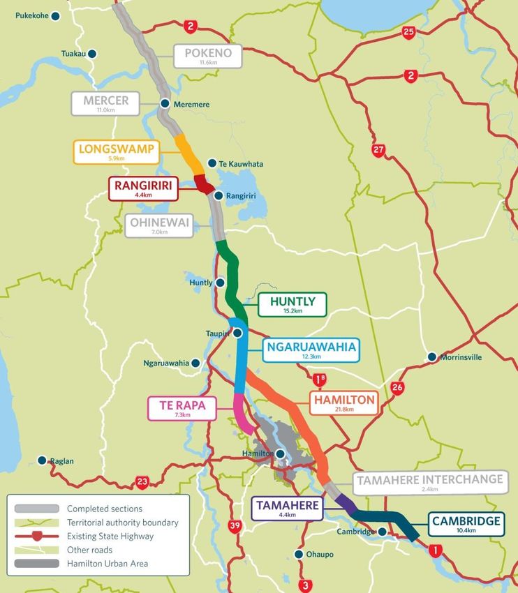
Expressway has been divided into 12 sections (see Figure 1-1). It is expected the Expressway will:
Improve economic growth and productivity for Auckland, Waikato and Bay of Plenty through
more efficient movement of people and freight between Auckland, Hamilton, Tauranga and
Rotorua;
Improve the reliability of the transport network by providing a more robust and safer road
network between Auckland, Hamilton, Tauranga and Rotorua;
Reduce travel times between Waikato and Auckland; and
Support the growth strategy for the central Waikato.
19 February 2014
Ruakura Interchange – Notice of Requirement   5

Figure 1-1 – Map of the Waikato Expressway

19 February 2014
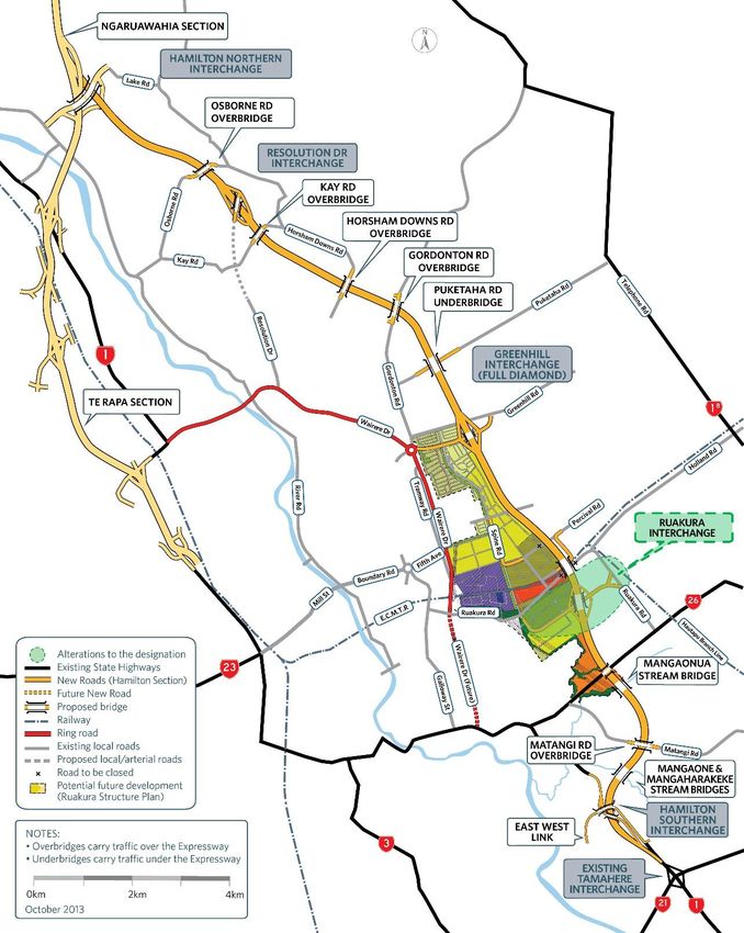
Ruakura Interchange – Notice of Requirement                         6

1.5       Waikato Expressway – Hamilton Section
The Hamilton Section is located on the eastern side of the city of Hamilton. The Hamilton Section
adjoins the recently completed Ngaruawahia Section to the north, and the existing Tamahere
Interchange to the south. It is approximately 22km in length. Figure 1-2 shows the scope of the
Hamilton Section.

Figure 1-2 – Map of the Waikato Expressway (Hamilton Section)

19 February 2014
Ruakura Interchange – Notice of Requirement 7
1.6 Project Specific Objectives
The specific project objectives for the Hamilton Section are as follows:
Contribute to the GPS priorities of national economic growth and productivity;
Take into account the principles of the Treaty of Waitangi;
Form part of an ultimate expressway facility between Auckland and Cambridge;
Provide a high level of service and safety for inter-regional and inter-centre traffic for a
planning horizon of at least 30 years;
Provide for the safe and efficient movement of state highway traffic between Hamilton and
major destinations to the north of Hamilton;
Minimise any adverse impacts and improve where feasible, the natural, physical, cultural and
social environment of the region;
Provide an appropriate return on investment for the project as a whole; and
Maximise the economic viability of the project as measured by its Benefit/Cost Ratio and
general value for money principles.
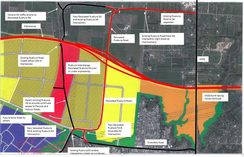
1.7 Ruakura Interchange – Proposed Alteration
The purpose of this NOR is to alter the existing designation and specifically includes the following:
Widening of the designation to accommodate the Ruakura Interchange ramps, connecting
roundabouts, and stormwater wetland;
Closure of the existing Ruakura Road either side of the Expressway and consequently
shortening of the bridge over the rail line;
Retention of Ruakura Road on both sides of the Expressway in order to provide continued
property access;
Relocation of Ruakura Road between the Ruakura Road/Silverdale Road intersection and
the existing Ruakura Road near the Vaile Road intersection to connect with the proposed
Ruakura Interchange, including:
o Existing Ruakura/Silverdale intersection closed via cul-de-sac (road retained for
access) and creation of a new relocated Ruakura Rd/Silverdale Rd intersection
o New relocated Ruakura Road/Existing Ruakura Road (west) intersection
Provision of a tee intersection where the relocated Ruakura Road meets the existing
Ruakura Road (east);
Upgrading the existing Ruakura Road between the new intersection with the relocated
Ruakura Road and the Ruakura Road/SH26 intersection;
19 February 2014
Ruakura Interchange – Notice of Requirement 8
Extension of the designation to cover the existing Ruakura Road (from the intersection with
the relocated Ruakura Road up to SH 26);
Provision for the relocated Ruakura Road to pass either over or under the Expressway; and
Provision for stormwater attenuation and disposal from the relocated Ruakura Road and
Ruakura Interchange.
Refer to Figure 1-3 below for the Scope of Works.
19 February 2014Ruakura Interchange – Notice of Requirement 9 Figure 1-3 – Scope of Works 19 February 2014
Ruakura Interchange – Notice of Requirement 10
2 Background
2.1 Existing Designations and Conditions
The route selection and alignment of the Hamilton Section was determined as part of a wider project
which commenced in 1995 and covered the long term development of State Highway 1 (SH1) between
Ohinewai and Cambridge. The Notice of Requirement for the original designation was lodged in
2001 and the designation was secured in 2005, following an appeal hearing before the Environment
Court in 2004.
Key aspects of the designated route are:
The need for the Hamilton Section of the Expressway to provide convenient and efficient
connections to the City's arterial network - as well as providing for the efficient and
uninterrupted passage of inter-regional traffic on the nation's primary trunk route;
A decision by the Agency that the Hamilton Section should pass to the east of Hamilton City -
rather than to the west;
A decision by the Agency confirming that the southern end of the route is to link into the
existing State Highway at Tamahere - rather than link directly into the designated Cambridge
Bypass via an alignment generally following the Cambridge Branch rail line. This issue was
the main focus of the appeal hearing in 2004.
Table 1-1 summarises the existing designations for the Hamilton Section and other existing relevant
designations by the Agency.
District District Code Activity Location Comments
Plan
Map No.
Waikato 1, 3, 4, 8, J1 State Highway 1 (Limited From Franklin
13, 14 access except those parts District/Waikato District
within the former boroughs of boundary north of
Huntly and Ngaruawahia as at Meremere to Hamilton
October 1989, and that part of City/Waikato District
Taupiri between Mangawara boundary at Ruffell Road,
bridge and Kainui Road) and then from Hamilton
City/ Waikato District
boundary at Newell Road to
Waipa District/Waikato
District boundary at
Racecourse Road
Waikato 14, 15, 19 J3 State Highway 26 (limited From Hamilton
access) City/Waikato District
boundary at Matangi Road
to Matamata Piako
District/Waikato District
boundary
Waikato 8, 13, 14, J16 Road for state highway and Taupiri to Horotiu
33, 36, 37 road for access to state
highway (Waikato
Expressway, Ngaruawahia
Bypass.)
19 February 2014Ruakura Interchange – Notice of Requirement 11
District District Code Activity Location Comments
Plan
Map No.
Waikato 37, 14, 20, J17 Road for state highway and Lake Road to Bollard Road Designation
22, 24A road for access to state lapses in
highway (Waikato 2015
Expressway, Hamilton
Bypass.)
Hamilton 2, 3 90 Hamilton Bypass – State Kay Road to Gordonton 10 year
Highway and Access to State Road designation
Highway (lapses 2015)
Hamilton 20, 21, 30, 90a To manage the State highway Greenhill Road to 10 year
31, 40, 48, system, including planning, Mangaonua Gully (rollover designation
49 funding, design, supervision, from Waikato District Plan) (lapses 2014)
construction, and
maintenance and operations,
and improvements in
accordance with the Land
Transport Act 2003 and the
Government Roading Powers
Act 1989.
Table 2-1 – Existing Designations
There are two sets of conditions that relate to the existing Hamilton Section designation. These are:
NOR 1 – Waikato District – Horotiu to Tamahere; and
NOR 2 – Hamilton City – Horotiu to Tamahere.
Each set contains ten conditions, and both address the following matters (with some variations in
wording of individual conditions):
Description of works;
Construction Management Plan;
Archaeological/Cultural Matters;
Network Utilities;
Noise;
Landscape and Visual;
Effects of construction on existing drainage works;
Lighting;
Community Liaison; and
Term of Designation.
The conditions were confirmed with the designation in 2005, following the Environment Court
hearing in 2004. The NOR2 conditions only relate to a portion of the designated Expressway
between Kay Road and Horsham Downs Road. These conditions were required because at that time
only this section of the designated Expressway was located within Hamilton City, with the balance
of the designated Expressway being within the Waikato District. Since that time, the boundaries
between the two territorial authorities has changed, but the physical location of the designations has
19 February 2014Ruakura Interchange – Notice of Requirement 12
remained the same. As a consequence, the NOR1 conditions originally for the designations located
within the Waikato District now apply to some of the designations located within Hamilton City.
Only the NOR1 conditions apply to the designations to be altered by this NOR (J17 –Waikato District
Plan, and 90a Hamilton City Proposed District Plan). A full set of the NOR1 conditions is provided
in Appendix A.
2.2 Alterations to the Designation
On 30 September 2013, the Agency lodged a NOR detailing a series of alterations to the existing
designation. The NOR was divided into two bundles. The first bundle included the following
alterations to the designation, which the Agency requested be publicly notified under s95A(2)(b) of
the Resource Management Act 1991 (RMA). Accordingly these alterations were notified on 20
November 2013. A total of 18 submissions were received.
Alteration Relevant Council
Resolution Drive Interchange (Alteration U) WDC
Puketaha Road Arrangement (Alteration V) WDC
Greenhill Interchange (Alteration W) WDC & HCC
Southern Interchange and Cambridge Road Widening (Alteration Z) WDC
Table 2-2 – Publicly Notified Alterations
The second bundle included twelve minor alterations providing for local widening and narrow
points, and to make provision for stormwater treatment facilities. These alterations were lodged in a
separate bundle under the expectation that they were likely to be non-notified due to their minor
nature.
2.3 Resource Consents
On the same date (30 September 2013), the Agency lodged applications for the necessary resource
consents with Waikato Regional Council (WRC). As with the large alterations, the Agency requested
that these applications be publicly notified under s95A(2)(b) of the RMA. Accordingly these resource
consents were publicly notified on 20 November 2013.
The following resource consents are currently being sought from the WRC:
Land use Undertake earthworks including: soil disturbance, roading, tracking, and
vegetation clearance both within and outside of high risk erosion areas; cleanfill
and overburden disposal; and, any associated discharges of contaminants to
water or air association with the Hamilton Section of the Waikato Expressway
Water permit To dam and divert surface water in the Mangaonua and Mangaharakeke/
Mangaone gullies as a consequence of road construction in association with the
Hamilton Section of the Waikato Expressway
Land use Construction, operation, maintenance and removal of temporary bridges over
the Mangaonua and Mangaone streams including any associated discharges of
contaminants to water or air in association with the Hamilton Section of the
Waikato Expressway
19 February 2014Ruakura Interchange – Notice of Requirement 13
Land use Construction, operation and maintenance of the Mangaonua and Mangaone
Stream bridges including any associated discharges of contaminants to water
or air in association with the Hamilton Section of the Waikato Expressway.
Water Permit To drill below the water table to install bridge piles in association with the
Hamilton Section of the Waikato Expressway.
Water permit To take and divert groundwater and discharge groundwater to water in
association with the Hamilton Section of the Waikato Expressway.
To divert and discharge stormwater into water, and/or into or onto land,
Discharge
including the installation, operation and maintenance of discharge structures
permit
in association with the Hamilton Section of the Waikato Expressway.
Land use Construction, operation and maintenance of culverts including any associated
discharges of contaminants to water or air in association with the Hamilton
Section of the Waikato Expressway
Water Permit To dam and divert surface water in association with culvert construction,
operation and maintenance
Table 2-3 – WRC Consent Applications
19 submissions were received in relation to the notified WRC consent applications. A joint hearing
for the alterations and WRC consents is scheduled for April 2014. The alterations and consent
applications do not specifically address the Ruakura Interchange proposal with the exception of the
land use consent for earthworks, which has taken into consideration the requirements for the
Ruakura Interchange. Accordingly, there is a requirement to seek a separate alteration and resource
consents for the new Ruakura Interchange and associated works.
19 February 2014Ruakura Interchange – Notice of Requirement 14
3 Planning Context
3.1 Local Authority Boundary Changes
The future plan for local authority boundary changes is set out in the Strategic Agreement on Future
Urban Boundaries between the WDC and HCC, dated March 2005. The agreement identifies the
principles, direction and process for transfer of land.
Since the original designation was confirmed, boundary changes have occurred between HCC and
WDC.
The boundary between HCC and WDC generally follows the centreline of the Expressway in the
following locations:
Between Horsham Downs Road and old Borman Road; and
Between Greenhill Road and the Mangaonua Gully.
The rest of the Expressway designation is either wholly within the WDC or HCC jurisdictions as
follows:
Waikato District: Lake Road to Kay Road, Gordonton Road to Greenhill Road, Mangaonua
Gully to Tamahere interchange; and
Hamilton City: between Kay Road and Horsham Downs Road, and between old Borman Road
and Gordonton Road.
In relation to the Ruakura Interchange NOR, it is noted that the jurisdictional boundary generally
follows the centreline of the Expressway from Greenhill Road through to the Mangaonua Gully. The
NOR is therefore to both the WDC and HCC.
3.2 Ruakura Structure Plan
As discussed above, recent boundary changes between HCC and WDC have meant that a significant
area of land at Ruakura is now within the HCC jurisdiction. The development of this land is identified
in a number of high level documents including the Hamilton Urban Growth Strategy, the Access
Hamilton Transport Strategy and the Proposed Regional Policy Statement.
To enable the progressive development of this area, the Ruakura Structure Plan (Structure Plan) was
developed and notified as part of the Hamilton City Proposed District Plan (Proposed District Plan)
in December 2012. Submissions and further submissions have been received, and hearings have been
in progress since late 2013. In the meantime, the planning rules of the WDC’s District Plan still apply
to this area, despite now being within the jurisdiction of the HCC.
The Structure Plan includes an inland port, freight and logistics hub and other industrial land. The
Inland Port as proposed has an intermodal facility so that freight can be transferred to and from road
and rail. The Structure Plan also provides for research and innovation activities, and residential areas
for an eventual population of approximately 1,800 households, including the development of a
neighbourhood centre.
19 February 2014Ruakura Interchange – Notice of Requirement 15 Development of the Ruakura Logistics Zone and Ruakura Industrial Park Zone is proposed in three stages which tie in with the Waikato Regional Policy Statement’s (RPS) industrial land allocation in the Future Proof Area. At the time of notifying the Structure Plan (as part of the Proposed District Plan), discussions around the location of an interchange to service the Inland Port were still ongoing and this is reflected in the wording of the Structure Plan. The Agency has made a number of submission points in relation to the Structure Plan, as part of its overall submission on the Proposed District Plan. The Agency is generally supportive of the Structure Plan and in particular made reference to being in support of an interchange on the Waikato Expressway in the general vicinity of the Inland Port. 3.3 Ruakura Development Private Plan Change Tainui Group Holdings Limited (TGH) is the predominant landowner affected by the Structure Plan and is keen to see it being implemented. However, it was identified that existing planning rules transferred over from the WDC’s District Plan prohibit any application being made for urban development within this area. Given that the WDC rules are currently operative, they continue to apply until the Proposed Hamilton City District Plan (that includes the Structure Plan) has been made operative. Given the potential for lengthy delays, TGH have sought a Private Plan Change (PPC) for what is known as the Ruakura Development through the Environmental Protection Authority (EPA). On 31 July 2013, a ministerial direction was released, referring the PPC request to a Board of Inquiry (BOI). The PPC seeks to enable development of up to 389ha of land at Ruakura. This area is only part of the wider development proposed as part of the Structure Plan. TGH state that the area equates to approximately 30 years of development and aligns with the RPS industrial land allocations. The PPC will enable development to occur in the interim, but it is intended that it will be fully superseded by the Structure Plan once the Proposed District Plan is confirmed. Accordingly the PPC does not re-zone any land, rather it proposes to adopt mechanisms providing an overlying ‘schedule’. This allows a range of activities to be undertaken in identified areas, as well as existing rural activities. The PPC states that the construction of the Expressway has a direct relationship to land release, and that the industrial land allocation is limited to 80ha prior to the Expressway being opened. The PPC was publicly notified on 30 November 2013. Submissions have now closed, and 77 were received, including one by the Agency. The BOI hearing is scheduled to take place in May 2014. The Agency’s submission supports in part the PPC, subject to further information and amendments being made on specific matters as listed in the submission. 19 February 2014
Ruakura Interchange – Notice of Requirement                        16

4         Ruakura Interchange
The Agency is seeking to alter the existing designations for the Waikato Expressway (Hamilton
Section) in order to accommodate an interchange at Ruakura. This includes the relocation of
Ruakura Road, and removing the two north facing ramps at the SH26/Morrinsville Road
interchange. Should the Inland Port/Logistics Area and Industrial Area be approved through the
BOI hearing, it is imperative that a direct link is made to the Hamilton Section of the Waikato
Expressway, rather than relying on local roads to accommodate heavy vehicle movements. The
establishment of an interchange at Ruakura that will tie in with the Ruakura Development is the
safest and most efficient way of connecting this area to the wider roading network.

4.1       Form 18
Section 181 Resource Management Act 1991

To:       Waikato District Council
          Private Bag 544
          Ngaruawahia

And       Hamilton City Council
          Private Bag 3010
          Hamilton

1         The NZ Transport Agency (the Agency), a requiring authority pursuant to section 167 of the
          Resource Management Act 1991, and having financial responsibility for this proposed public
          work, gives notice to both Waikato District and Hamilton City Councils of a requirement for
          alterations to the following designations:
          J17 (Hamilton Bypass) of the Waikato District Plan; and
          90a (Hamilton Bypass) of the Hamilton City Proposed District Plan.

          Designation Purpose:
          Alteration to J17: Road Purposes - State Highway & Access to State Highway

          Alteration to 90a: Road Purposes – Local Road & Access to State Highway

          Designation Lapse Period:
          Waikato District Plan – 2015
          Hamilton City Proposed District Plan – 10 years (2015)

2         The site to which the requirement applies is as follows:
          Waikato District Council
          Part Lot 3 DPS14267 (SA11D/1380),
          Lot 8 DPS66853 (SA53C/665); and
          Road Reserve – Ruakura Road, Vaile Road and Davison Road

19 February 2014
Ruakura Interchange – Notice of Requirement 17
Hamilton City Council
Lot 1 DPS77458 (SA61C/243),
Lot 1 DPS78549 (SA61C/246),
Lot 8 DPS66853 (SA53C/665); and
Road Reserve – Ruakura Road and Silverdale Road
Please refer to Appendix B for copies of the Certificates of Title.
3 The nature of the alteration work is as follows:
Widening of the designation to accommodate the Ruakura Interchange ramps,
connecting roundabouts, and a stormwater wetland;
Closure of the existing Ruakura Road either side of the Expressway and consequently
shortening of the bridge over the rail line
Retention of Ruakura Road on both sides of the Expressway in order to provide
continued property access
Relocate Ruakura Road between the Ruakura Road/Silverdale Road intersection and
the existing Ruakura Road near the Vaile Road intersection to connect with the
proposed Ruakura Interchange, including:
o Existing Ruakura/Silverdale intersection closed via cul-de-sac (road retained for
access) and new relocated Ruakura Rd/Silverdale Rd intersection
o New relocated Ruakura Road/Existing Ruakura Road (west) intersection
Provision of a tee intersection where the relocated Ruakura Road meets the existing
Ruakura Road (east)
Upgrading the existing Ruakura Road between the new intersection with the
relocated Ruakura Road and the Ruakura Road/SH26 intersection
Extension of the designation to cover the existing Ruakura Road (from the intersection
with the re-aligned Ruakura Road up to SH 26)
Provision for the relocated Ruakura Road to pass either over or under the Expressway
Provisions for stormwater attenuation and disposal from the relocated Ruakura
Road and Ruakura Interchange
Please refer to Appendix C for plans in support of the NOR.
4 The nature of the proposed restrictions that would apply are:
In context of the assessment of environmental effects that follows, it is considered that the
existing conditions applying to the designation for the Hamilton Section of the Waikato
Expressway (NOR1), will adequately mitigate any potential environmental effects
associated with the alteration. Notwithstanding this, some further mitigation of effects will
need to be addressed in the WRC consents yet to be applied for.
19 February 2014Ruakura Interchange – Notice of Requirement 18
The existing designation conditions (NOR1) are included in Appendix A of this report and
the Agency requests that these conditions apply to this alteration.
5 The effects that the public work will have on the environment and the ways in which any
adverse effects will be mitigated are:
Please refer to the effects assessment below.
6 Alternative sites have been considered to the following extent:
The Agency has investigated alternatives and undertaken consultation to inform and gain
feedback from the public. Please refer to section 4.2 below.
7 The public work and designation are reasonably necessary for achieving the objectives of the
requiring authority because:
The proposed alteration is the outcome of a Network Connections investigation which
concluded that interchanges at Greenhill and Ruakura best served the area if the Ruakura
Structure Plan and in particular the Inland Port were to proceed. This alteration is lodged
on the basis that the upcoming BOI process for the PPC justifies the establishment of an
interchange at Ruakura.
8 The following resource consents are required from the Waikato Regional Council:
At this time the Agency is only seeking to lodge the NOR for the Ruakura Interchange. The
Agency is aware of the need to seek resource consents from the WRC for a number of
matters including, but not limited to: earthworks, water diversions, water takes, water
discharges, placement of structures within stream beds and stormwater discharges. The
Agency will seek the necessary consents from the WRC in due course.
9 The following consultation has been undertaken with the affected landowners:
Consultation undertaken by the Agency with respect to this NOR is detailed in Section 5 of
this report.
10 The following information is required to be included in this notice by the district plan,
regional plan, or any regulations made under the Resource Management Act 1991:
Notice of requirement assessment of effects;
Notice of requirement alteration plans.
19 February 2014Ruakura Interchange – Notice of Requirement 19 4.2 Consideration of Alternatives In early 2013, transport modelling work was undertaken to inform a network connections study to ascertain the most favourable network between Greenhill Road and SH26, with a view to integrating the Waikato Expressway connectivity with the proposed Structure Plan and associated generation of a large number of heavy commercial vehicle movements. The study identified that interchanges at Greenhill and Ruakura best served the area if the Structure Plan and in particular the Inland Port were to proceed. The outcomes were discussed with HCC, WDC and TGH (and generally accepted as appropriate) prior to being subject to the Agency’s internal approval process. The assessment was based on the fundamental assumption that an Inland Port would be developed along with the logistic zone activities. It is therefore expected that the connection at SH26 would be retained and no connection provided at Ruakura if alternative forms of development were to occur. This point has been reiterated in the Agency’s submission on the PPC. The full assessment of options between Greenhill Road and SH26 is contained in the report ‘Network Connections Summary Report – March 2013 Update’, prepared by Opus and attached as Appendix D. 4.3 Assessment of Environmental Effects 4.3.1 Baseline for the Environmental Effects Assessment In terms of assessing the potential environmental effects of the Ruakura Interchange, careful consideration needs to be given to what constitutes the baseline for the assessment. The sole purpose for establishing the Ruakura Interchange is to provide an appropriate link between the Ruakura Development and the Expressway. It follows that if the Ruakura Development does not proceed, then there is no basis for the Agency to pursue the Ruakura Interchange and development of the Expressway will continue with the north facing ramps at the SH26 interchange. Given the trigger effect that the Ruakura Development has on the Ruakura Interchange, it follows that the baseline for assessing the Ruakura Interchange should include the Ruakura Development. However, as the PPC will be superseded by the Structure Plan once the Proposed District Plan is made operative, this NOR has used the Proposed District Plan to form the baseline upon which the potential environmental effects of the Ruakura Interchange have been assessed. This approach is considered appropriate given that the land use as set out in the Structure Plan is underpinned by the policy direction given by the RPS, the Future Proof Strategy, the Hamilton Urban Growth Strategy and the Access Hamilton Strategy. The key components of the Proposed District Plan that form the baseline for this assessment include: Inland Port/Ruakura Logistics (~150ha); and Industrial Park (~210ha). It also follows that the Expressway (as currently designated) is included as part of the baseline, as this will proceed regardless of whether the Structure Plan is given effect to. 19 February 2014
Ruakura Interchange – Notice of Requirement 20
The potential environmental effects associated with the Ruakura Interchange alteration have been
assessed under the following headings: traffic effects, drainage and flooding effects, landscape, visual
amenity and urban design effects, contamination effects, noise effects, ecological effects,
archaeological effects, air quality effects and vibration effects.
4.3.2 Traffic Effects
The potential traffic effects of the Ruakura Interchange and relocated Ruakura Road have been
assessed by a Transportation Engineer familiar with the Expressway project and site. The potential
effects and proposed mitigation are summarised below.
Baseline for Traffic Effects Assessment
For the purpose of this traffic assessment the baseline includes the completed Waikato Expressway
and the Proposed District Plan on the basis that the Ruakura Structure Plan with its Inland Port will
proceed. It includes:
Land use as proposed by the Structure Plan. This includes an Inland Port (shaded red in Figure
4-1 below) and associated activities within the Ruakura Development area, industrial parks and
residential development in the north (Chedworth Park Development).
Relocation of a section of Ruakura Road (between Silverdale Road and Holland Road) to allow
the Ruakura Inland Port to be developed as this relies on direct access to the East Coast Main
Trunk Railway. To achieve this requires stoppage of Ruakura Road either side of the Expressway.
However, to ensure continued access to Percival Road and Ryburn Road, Ruakura Road west of
the Expressway will remain open.
The existing Hamilton Section of the Waikato Expressway designation, which has north facing
ramps at SH26, a full interchange near Greenhill Road (to the north) and south facing ramps at
the Southern Interchange (near Cherry Lane).
For the purpose of the traffic assessment the adopted network baseline is illustrated on Figure 4-1
below.
The only difference between the assumed baseline described above and the Ruakura Interchange
NOR is therefore the replacement of the SH26 north facing ramps with a full interchange on the
relocated Ruakura Road. Note, by year 2041, the Spine Road (future connection between Ruakura
and Greenhill as part of the Structure Plan) is considered to be part of the baseline.
19 February 2014Ruakura Interchange – Notice of Requirement 21
Figure 4-1: Network Baseline for Traffic Assessment
In year 2012 Ruakura Road carried 5,100vpd between Silverdale Road and Holland Road and
2,900vpd between Holland Road and SH26, based on existing traffic count data. The existing sealed
carriageway width is between 7m and 8m wide consisting of two 3.5m traffic lanes and a narrow
shoulder. The Waikato District Council Plan lists Ruakura Road as an Arterial Road. Hence its main
function is to:
1. form a strategic network of district importance and
2. provide for the collection and distribution of goods significant to the district’s economy.
The District Plan also notes that the through traffic function needs to be balanced against the
property access function. On this basis the use of a section of Ruakura Road to provide connectivity
between SH26 and the Expressway is in our view in line with its intended function.
Methodology
The traffic flows have been extracted using the Waikato Regional Transportation Model (WRTM).
This model has been developed by a consortium of road controlling authorities, known as Local
Authority Shared Services (LASS), which includes the majority of local authorities within the
Waikato Region and the NZTA.
19 February 2014Ruakura Interchange – Notice of Requirement 22
The WRTM has a validated 2006 network and two forecast years being 2021 and 2041. The model
was peer reviewed as fit for purpose by Flow Transportation Specialists on behalf of LASS. Morning
and afternoon peaks (as 2 hour periods) are modelled in conjunction with an interpeak period (also
2 hours), which when compiled together provide an estimate of the average daily flow. Traffic flows
are available for all-vehicle types or just the heavy vehicle component. The latter has been used to
determine the percentage of Heavy Commercial Vehicles (HCV) for the intersection analysis.
Traffic flows have been extracted from the project models referred to as Network 28 and 29, both of
which have adopted the Structure Plan. Network 28 reflects the existing Hamilton Section
designation including the north facing ramps on SH26. Network 29 includes all the proposed
Alterations to Designation which have already been lodged and publicly notified and includes the
Ruakura Interchange (north and south facing ramps).
Key junctions within the Ruakura area have been subjected to a detailed assessment of the likely
operating level of service (LOS) resulting from the Notice of Requirement (NOR). The key
intersections are considered to be:
Existing intersection of Ruakura Rd/SH26 (cross road),
The new intersection of Relocated Ruakura Rd/Existing Ruakura Road (Tee layout),
the Ruakura Interchange ramp terminal junctions (roundabouts),
The Relocated Ruakura Rd/Silverdale Rd intersection, and
The revised intersection layout at Ruakura Road/Silverdale Road (2021) and when the Spine
Road is added in the year 2041 network.
Intersection capacity and LOS has been determined using the SIDRA modelling software based on
year 2041 peak hour flows. The exception to this is the Ruakura Road/Silverdale Road intersection
which has also been assessed using year 2021 flows, because the junction layout does not include the
Spine Road in year 2021.
The SIDRA modelling parameters adopted for the assessment include:
use of peak hour factors (0.95) with a 30min peak period,
heavy vehicle content based on predictions from the project traffic models,
lane capacity values based on the SIDRA software recommendations,
Level of Service based on the Highway Capacity Manual intersection delays for the intersection
type being assessed.
Although the SIDRA results have been tabulated as per the software output this in no way indicates
a high level of accuracy with the results. Intersection delays include the geometric delay component
associated with turning vehicles negotiating the intersection. A copy of the SIDRA outputs can be
provided in request.
Traffic Flows on the Network
Traffic flow diagrams have been created to illustrate the change in daily 2041 traffic volumes on key
routes most likely to be affected by the Ruakura Interchange. The four figures below represent daily
flows on the following networks:
19 February 2014Ruakura Interchange – Notice of Requirement 23
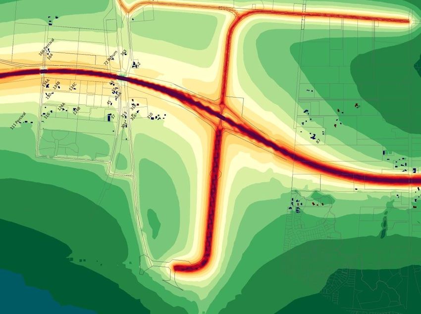
Figure 4-2 indicates the ramp flows at SH26 (baseline) and Ruakura Interchange (NOR).
Figure 4-3 indicates the assumed Baseline flows (Network 28). As the figure illustrates this
includes north facing ramps only at SH26 (Morrinsville Road) for local traffic to access the
Expressway.
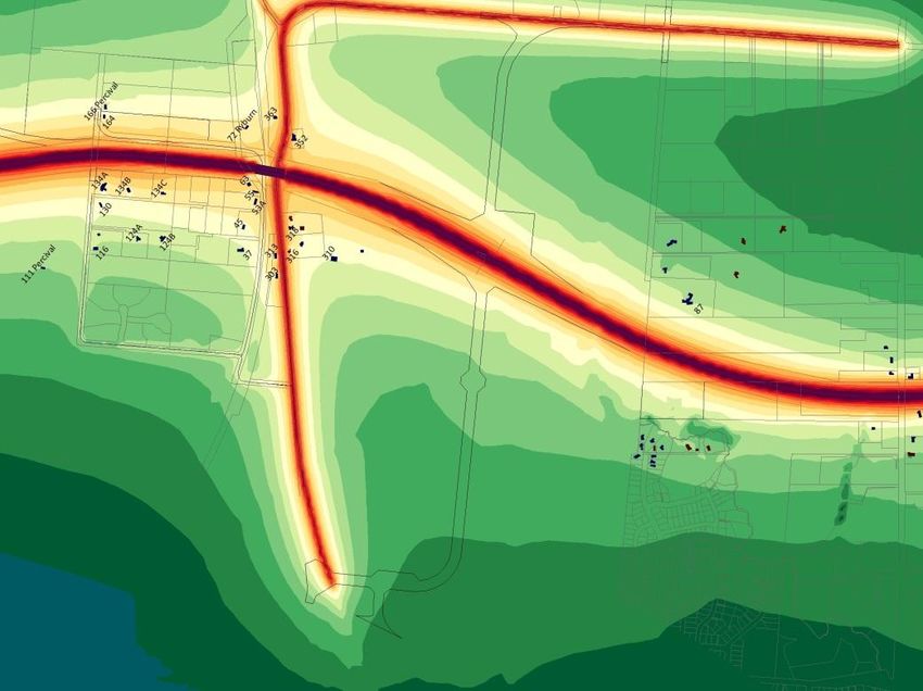
Figure 4-4 indicates the NOR flows with a Ruakura Interchange and no connection between the
Expressway and SH26 (Network 29).
Figure 4-5 indicates the difference in daily flows between the baseline (Figure 4-3) and NOR
(Figure 4-4).
In all cases the black numbers represent the total daily flow, whilst the number of HCV’s are shown
in red.
Baseline - SH26 North Facing Ramps
NOR – Ruakura Interchange Ramps
Figure 4-2: Year 2041 Traffic Flows on the Interchange Ramps
19 February 2014Ruakura Interchange – Notice of Requirement 24 Figure 4-3 – 2041 Daily Traffic Flows for Baseline (Network 28) 19 February 2014
Ruakura Interchange – Notice of Requirement   25

Figure 4-4 – 2041 Daily Traffic Flows for NOR (Network 29)

19 February 2014
Ruakura Interchange – Notice of Requirement           26

Figure 4-5 – 2041 Difference in Daily Traffic Flows (Alteration minus Baseline)

19 February 2014
Ruakura Interchange – Notice of Requirement 27
In general the traffic flow diagrams illustrate that:
The Ruakura Interchange attracts an additional 4,900vpd (1,400 HCVs) onto the southern
portion of the Hamilton Section of the Expressway which is an increase of +34%. This is
considered a positive effect as it reduces traffic flows on Cambridge Road and the western end of
SH26.
Similarly, the interchange attracts an additional 2,300vpd (1,500 HCVs) on to the section of
Expressway immediately north of the Ruakura Interchange. Again this is a positive impact as it
significantly reduces traffic on the Spine Road which would otherwise traverse through
residential areas.
As the Ruakura Interchange provides a direct connection onto the Expressway, the relocated
Ruakura Road shows a significant increase in predicted traffic flows either side of the
Expressway. This is not considered to be detrimental as the road is located in an industrial area
and will be constructed to cope with the expected traffic flows. The increase on Ruakura Rd
however is offset by a positive reduction in traffic flows on the Spine Road and the Greenhill
Arterial connection.
Ruakura Road between Vaile Road and SH26 is expected to increase by 1,600 vehicles per day as
traffic from SH26 uses Ruakura Road to access the Ruakura Interchange. The majority of this
increase consists of light vehicles. To improve safety, the Agency will widen Ruakura Road
between the intersection of the Relocated Ruakura Road and SH26 to provide a minimum of two
3.5m traffic lanes with a 1.5m wide shoulder on either side of the road.
Relocated Ruakura Road between the interchange and the main entrance to the proposed port
site will increase by approximately 8,300vpd. A significant portion of this are HCV’s (2,600vpd).
This increase is due to the improved connectivity between the Inland Port and the Expressway,
rather than traffic using the Spine Road and the Greenhill Interchange. This is also evidenced
by the high number of HCV’s using the Ruakura Interchange ramps (Figure 4- 2).
Overall it is concluded that the change in traffic flows on the network resulting from the NOR are no
more than minor. It also encourages the “right traffic” onto the “right roads”. That is, HCV’s have
direct access onto the Expressway and therefore do not need to traverse through city roads to access
the Greenhill Interchange or Southern Interchange.
Traffic Effects Assessment
In terms of traffic effects this assessment considers the proposal in terms of the effects on various
intersections affected by the alteration, property access, alternate transport modes and effects during
construction.
Ruakura Interchange On/Off Ramps
The NOR layout proposes two new roundabouts on Relocated Ruakura Road to serve the Expressway
off and on ramps. The roundabouts are expected to be about 35m in diameter to cater for the large
number of heavy vehicles that are expected to use the interchange. The speed limit on Relocated
Ruakura Road is proposed to be 60km/h west of the eastern roundabout. Intersection sight lines to
and from the intersections will be in accordance with the relevant design standards.
Using the SIDRA software, both the off-ramp and on-ramp configurations can adequately cope with
the excepted year 2041 peak period flows, providing a likely level of service (LOS) B (on a scale of A:
excellent to F: poor) as shown in Table 4-1. The project objective is to ensure a LOS C or better at all
Expressway ramp terminals, hence the proposed roundabouts meet this criteria. Please refer to
19 February 2014Ruakura Interchange – Notice of Requirement 28
Appendix E – Traffic Assessment Results for detailed analysis of the information provided in the
following tables.
Intersection Approach Movement Demand Average 95%ile LOS
Flow Delay Queue
(vph) (seconds) (m)
AM PM AM PM AM PM AM PM
East Ruakura Road 321 243 8 9 13 13 A A
Roundabout
Eastern
North – Off Ramp 231 296 14 18 9 18 B B
West Ruakura Road 207 595 9 13 0 0 A B
South – Off Ramp 313 152 15 13 21 8 B B
Roundabout
East Ruakura Road 501 363 6 6 0 0 A A
Western
West Ruakura Road 360 879 6 6 14 53 A A
Table 4-1: On and Off Ramp Predicted Intersection Delays at Ruakura Interchange – Year 2041
It is recognised that the addition of two new intersections on Relocated Ruakura Road will pose some
additional safety risk on users of the existing Ruakura Road due to the introduction of new vehicle
conflicts. However, the NOR removes the two Tee intersections on SH26 that were part of the
existing designation. Accordingly, an assessment of the overall safety effect has been conducted using
available crash prediction models. This indicates that although there is a potential for more injury
crashes with the NOR, the lower speed limit on Ruakura Road (60km/h) will result in an overall
lower social cost per injury crash as shown in Table 4-2 below.
Baseline (Two Tee-intersections within NOR (Two Roundabout
80km/h speed environment) intersections within 60km/h
speed environment)
Predicted Injury 0.587 0.837
crashes per year
Social Cost per $427,000 $195,000
Injury
Total Cost/yr $251,000 $163,000
Table 4-2-Comparison of Predicted Accident Cost for Baseline and NOR
It should also be noted that traffic modelling indicates more vehicles (light and heavy) use the
Expressway under the NOR than with the Baseline. Hence, we would expect an overall reduction in
crashes with the NOR layout as the vehicles transfer from city roads onto the Expressway, which has
no conflicting intersections or adjoining property access.
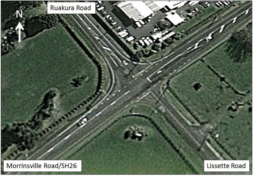
Existing Ruakura Road/SH26
Traffic modelling shows that traffic flows and patterns at this intersection will change due to the
NOR. Although the existing intersection has been the site of a number of fatalities over the past three
years, there appears to be no capacity issues. The existing SH26/Ruakura Road/Lissette Road
intersection provides a fully dedicated right turn bay. Site distance is also considered to be more
than adequate for the 80km/h speed environment.
19 February 2014Ruakura Interchange – Notice of Requirement 29
Figure 4-6: Location Map
The following tables (4-3 to 4-6) summarise the traffic assessment. The green highlighted cells
indicate an improvement, whilst the red cells show a dis-benefit.
In all cases the intersection is expected to operate as well as the existing or slightly better. The
maximum increase in delays is 1sec/vehicle, whereas for some movements the delay reduces by up
to 6sec/vehicle. In reality motorists would not be aware of such a small change. The main change is
the increase in right turn traffic flows into Ruakura Road and the increase in the left turn flows out
of Ruakura Road. This is offset by a decrease in the through flow on SH26.
Demand Flow Average Delay
Approach (vph) Deg Sat (s/veh) 95% Queue (m)
Baseline NOR Baseline NOR Baseline NOR Baseline NOR
Left 5 5 0.04 0.03 19 19 1 1
Lissette Rd Through 5 5 0.04 0.03 19 18 1 1
Right 5 5 0.04 0.03 19 18 1 1
Left 5 5 0.26 0.22 11 11 0 0
Sh26 460 397 0.26 0.22 0 0 0 0
westbound Through
Right 77 145 0.07 0.12 12 12 2 5
Left 24 72 0.03 0.09 15 15 1 3
Ruakura Rd Through 5 5 0.28 0.18 26 21 9 5
Right 75 65 0.28 0.18 26 21 9 5
Left 98 62 0.06 0.04 11 11 0 0
Sh26 241 201 0.14 0.12 2 2 9 6
eastbound Through
Right 5 5 0.14 0.12 13 13 9 6
Overall 1006 974 0.28 0.22 5 6 9 6
Table 4-3: Existing Ruakura Road/SH26/Lissette Road Intersection 2021 AM Peak
19 February 2014Ruakura Interchange – Notice of Requirement 30
Approach Demand Flow Deg Sat Average Delay 95% Queue (m)
(vph) (s/veh)
Baseline NOR Baseline NOR Baselin NOR Baselin NOR
e e
Left 5 5 0.04 0.04 19 19 1 1
Lissette Rd Through 5 5 0.04 0.04 19 18 1 1
Right 5 5 0.04 0.04 19 19 1 1
Left 5 5 0.17 0.15 11 11 0 0
Sh26
Through 302 264 0.17 0.15 0 0 0 0
westbound
Right 35 89 0.04 0.10 13 13 1 3
Left 84 151 0.14 0.25 17 17 4 9
Ruakura Rd Through 5 5 0.34 0.22 27 21 12 6
Right 91 77 0.34 0.22 27 21 12 6
Left 68 59 0.05 0.04 11 11 0 0
Sh26
Through 454 395 0.26 0.22 2 1 16 12
eastbound
Right 5 5 0.26 0.22 12 12 16 12
Overall 1065 1066 0.34 0.25 6 7 16 12
Table 4-4: Existing Ruakura Road/SH26/Lissette Road Intersection 2021 PM Peak
Demand Flow Average Delay
Approach (vph) Deg Sat (s/veh) 95% Queue (m)
Baseline NOR Baseline NOR Baseline NOR Baseline NOR
Left 5 5 0.04 0.03 19 19 1 1
Lissette Rd Through 5 5 0.04 0.03 19 18 1 1
Right 5 5 0.04 0.03 19 18 1 1
Left 5 5 0.23 0.21 11 11 0 0
Sh26 Through 431 380 0.23 0.21 0 0 0 0
westbound
Right 106 146 0.10 0.12 13 12 3 4
Left 35 73 0.05 0.09 15 15 1 3
Ruakura Rd Through 5 5 0.28 0.22 23 21 8 6
Right 89 82 0.28 0.22 24 21 8 6
Left 137 99 0.08 0.06 11 11 0 0
Sh26 Through 269 241 0.15 0.13 2 2 9 7
eastbound
Right 5 5 0.15 0.13 13 13 9 7
Overall 1099 1053 0.28 0.22 6 6 9 7
Table 4-5: Existing Ruakura Road/SH26/Lissette Road Intersection 2041 AM Peak
19 February 2014Ruakura Interchange – Notice of Requirement 31
Demand Flow Average Delay
Approach (vph) Deg Sat (s/veh) 95% Queue (m)
Baseline NOR Baseline NOR Baseline NOR Baseline NOR
Left 5 5 0.03 0.03 18 18 1 1
Lissette Rd Through 5 5 0.03 0.03 18 18 1 1
Right 5 5 0.03 0.03 18 18 1 1
Left 5 5 0.18 0.16 11 11 0 0
Sh26 Through 328 297 0.18 0.16 0 0 0 0
westbound
Right 49 89 0.05 0.08 13 13 2 3
Left 12 155 0.02 0.23 16 16 1 7
Ruakura Rd Through 5 5 0.36 0.53 23 24 12 21
Right 127 217 0.36 0.53 23 24 12 21
Left 72 59 0.04 0.03 11 11 0 0
Sh26 Through 406 367 0.22 0.2 2 1 13 11
eastbound
Right 5 5 0.22 0.2 12 12 13 11
Overall 1026 1216 0.36 0.53 6 9 13 21
Table 4-6: Existing Ruakura Road/SH26/Lissette Road Intersection 2041 PM Peak
Over the past 3 years, there have been two fatal crashes and a number of non-injury crashes at this
intersection. Although there is an expected increase in turning traffic volumes, a safety review using
appropriate accident prediction models, indicates that there is virtually no change in the predicted
number of injury crashes. This is because the combination of turning and opposing traffic flows are
virtually the same between the baseline and NOR.
Based on the results of the year 2021 and 2041 traffic assessment the impact of the NOR proposal is
considered to be less than minor on the operational performance of the SH26/Ruakura Road
Intersection, when compared with the Baseline (North facing ramps at SH26). It is noted that the
Agency is looking at improvement options for this intersection to address existing safety concerns.
Relocated Ruakura Road/existing Ruakura Road (East)
The Relocated Ruakura Road/existing Ruakura Road Intersection is located east of the proposed
Ruakura Interchange and resembles a Tee junction layout on a horizontal curve. Relocated Ruakura
Road will be the major road with a speed limit of 80km/h.
Tables 4-7 and 4-8 illustrate that traffic flows at this intersection are expected to increase with the
NOR layout. However, the intersection is expected to operate well within its available capacity with
minimal delays. The overall LOS is B or better hence traffic from Holland Road that needs to divert
through this intersection should not experience any substantial delays (average predicted delay is
12sec/veh in either peak in year 2041).
19 February 2014Ruakura Interchange – Notice of Requirement 32
Demand Flow Average Delay
Approach (vph) Deg Sat (s/veh) 95% Queue (m)
Baseline NOR Baseline NOR Baseline NOR Baseline NOR
Ruakura Through 155 240 0.09 0.14 0 0 0 0
Rd 7 12 0.00 0.01 11 11 0 0
Westbound Right
Holland Left 9 12 0.06 0.08 11 12 2 2
Road 78 81 0.06 0.08 11 12 2 2
Extension Right
Ruakura Left 32 34 0.07 0.13 11 11 0 0
Rd 85 200 0.07 0.13 0 0 0 0
Eastbound Through
Overall 366 578 0.09 0.14 4 3 2 2
Table 4-7: Relocated Ruakura Road/Existing Ruakura Road East of Expressway - Year 2041 AM
Demand Flow Average Delay
Approach (vph) Deg Sat (s/veh) 95% Queue (m)
Baseline NOR Baseline NOR Baseline NOR Baseline NOR
Ruakura Through 96 194 0.06 0.11 0 0 0 0
Rd 9 15 0.01 0.01 11 12 0 0
Westbound Right
Holland Left 11 14 0.04 0.06 11 12 1 1
Road 48 49 0.04 0.06 12 12 1 1
Extension Right
Ruakura Left 92 82 0.15 0.20 11 11 0 0
Rd 176 279 0.15 0.20 0 0 0 0
Eastbound Through
Overall 432 633 0.15 0.20 4 3 1 1
Table 4-8: Relocated Ruakura Road/Existing Ruakura Road East of Expressway - Year 2041 PM
Relocated Ruakura Road/Silverdale Road
The intersection of Relocated Ruakura Road and Silverdale Road will take the form of a simple Tee
junction with priority given to Relocated Ruakura Road. The intersection will be in a 60km/h posted
speed limit.
Table 4-9 and 4-10 illustrate that traffic flows through this intersection are likely to decrease due to
the NOR. This decrease in vehicle flow has an overall positive effect on the intersection performance
especially in the PM peak.
Demand Flow Average Delay
Approach (vph) Deg Sat (s/veh) 95% Queue (m)
Baseline NOR Baseline NOR Baseline NOR Baseline NOR
Ruakura Left 36 166 0.15 0.60 60 52 13 55
Rd NB Through 333 316 0.75 0.56 59 44 80 54
Ruakura Through 461 387 0.22 0.18 12 11 50 33
Rd SB Right 799 740 0.87 0.86 29 31 239 212
Silverdale Left 472 482 0.85 0.84 58 49 210 179
Rd 55 49 0.59 0.44 73 61 24 18
Right
Overall 2155 2141 0.87 0.86 38 36 239 212
Table 4-9: Relocated Ruakura Road/Silverdale Road Tee Intersection Year 2041 AM
19 February 2014You can also read