Wairoa River Valley Strategy - October 2013 - Ko Te Wairoa, He Whakaora Whenua, He Whakaora Tangata - Western Bay of Plenty District ...
←
→
Page content transcription
If your browser does not render page correctly, please read the page content below
Ko Te Wairoa,
    He Whakaora Whenua,
    He Whakaora Tangata.

        “The Wairoa River,
         a River that gives
life to the land and the People”

            Wairoa River Valley Strategy
                                   October 2013
Te Karanga o te Kuia
                                                     “E noho ana ahau I runga
                                                    I te taumata o aku tupuna,
                                                  no te hono I wairua, I hono ai
                                                 te ture wairua ki te ture tangata
                                               waihoki te Pouriuri ki te Ao Marama,
                                              Tenei te Mana whakaihi, whakawehi,
                                               Whakaora ki te moemoea I tuku iho
                                                      I tuku iho mana tikanga
                                                  mo to tatou Awa o Te Wairoa,
                                              Hei oranga mo nga whakatupuranga
                                                           Kei te heke mai”
                                                   Kuia Minnihaha (Poumako) Gotz

                          “I stand on the high sacred summit, the speaking place of our Ancestors,
                  that is the spiritual link between our Spiritual laws and the physical teachings of today.
             Leave the long dark night of ignorance and emerge into the world of light, of understanding.
      Absolute sacred Authority, power realised manifesting as intellectual creative inspiration – awe inspiring -
encompassing energy, revitalising, strengthening – the spiritual vision, that which has been handed down to us by our
ancestors, guardianship of our River, Te Wairoa, the source of living healing waters providing sustenance for us all. The
  River is the link between our past, present and future, a Cultural, Physical and Spiritual Icon, gifted to and for the
                                                     coming generations.”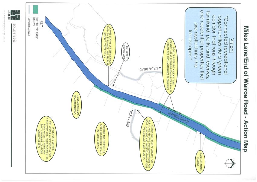
Table of Contents

1.   Introduction                               2
2.   The Vision – Where We Want To Be in 2055   8
3.   Background                                 9
     3.1 The Legislative Context                9
     3.2 Consultation Process                   10
     3.3 Lay out of the WRVS                    11
     3.4 Partnership                            11
     3.5 The Community                          12
     3.6 Implementing the WRVS                  12
     3.7 Delivering the WRVS                    13
4.   Management Themes                          15 - 51
5.   Local Management Areas                     52 – 73
Glossary                                        75
References                                      76 - 78
1 Introduction
The Wairoa River flows into the Tauranga Harbour, located on the eastern coast of the North Island of New Zealand. The Wairoa River
Valley is a special environment valued by the community for its natural and spiritual qualities. There are pressures both existing and
emerging that are impacting on the Wairoa River and its environs. In particular, a surge in lifestyle block and residential subdivision and
development, recreation, access and land use practices can seriously impact on those natural, cultural, social and economic assets
that the community values.
This Section provides details on the definition of the Wairoa River Valley environment for the purposes of this strategy, sets a context for
the partnership that is inherent to the strategy and details where the strategy ‘fits’ in the legislative context.
What is the Wairoa River Valley environment?
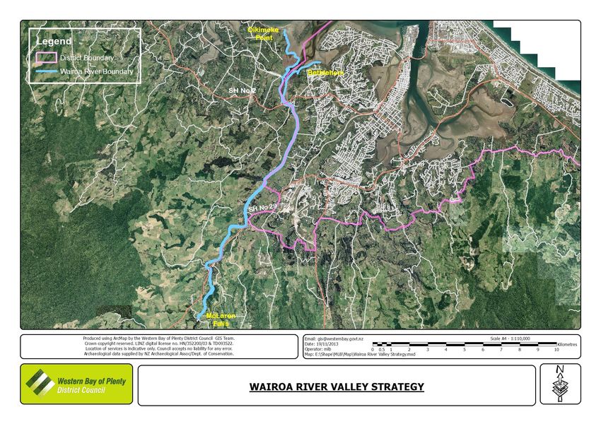
The Wairoa River flows into the Tauranga Harbour located on the eastern coast of the North Island of New Zealand and is shown on
Figure 1. To the south and west are the bush-covered Kaimai Ranges. The Wairoa River and its tributaries form the largest catchment
of Tauranga Harbour.1 The Wairoa River is approximately 14km in length and the largest freshwater tributary to Tauranga Harbour with
a discharge of approximately 39l/s/square km. There are a number of tributaries that feed directly into the Wairoa River; the main
tributaries include Mangakarengorengo, Opuiaki, Mangapapa, Omanawa below Ruahihi, and Ruangangara (Ohourere). The
tributaries upstream of the Wairoa River Valley are recognised as integral to the river valley environment but are outside the definition
of the Wairoa River Valley. It is recognised that the Ruahihi Canal is in close proximity to the Wairoa River Valley as defined below and
where appropriate potential opportunities for inclusion of this area in the Strategy are identified.
The definition of the Wairoa River Valley is provided below for the purposes of the Wairoa River Valley Strategy (WRVS).
“The Wairoa River Valley extends from McLaren Falls Bridge downstream to where the river meets the Tauranga Harbour
(Oikimoke Point to the equivalent northern point in Bethlehem). It extends up to the dominant ridgeline beside the river
and to encompass the communities of interest either side of the riverbank”
Wairoa River Valley Strategy October 2013 Page 3
Wairoa River Valley Strategy October 2013 Page 4
This definition is not a legal definition. The definition has resulted from both background research and consultation with the
community. There has been concern voiced by the Tangata Whenua and some parts of the community that the study boundaries
must include the whole catchment, from the smallest stream in the Kaimai Ranges to the very mouth of the river in at the Tauranga
Harbour, and that to only study the Wairoa River from McLaren Falls down to the harbour is not addressing the causes of many issues
that are of concern to people along the Wairoa River Valley. The WRVS addresses the Wairoa River from McLaren Falls Bridge
downstream. The Wairoa River tributaries are not included in the study area; however the Strategy recognises their importance. The
Councils consider this to be the first step where there is the most pressure.
Figure 1: Map of Wairoa River Valley (Source: E.Stokes (1980) ‘A History of Tauranga County’)

                                                                                                   The WRVS does not directly
                                                                                                   address the future use,
                                                                                                   management and development
                                                                                                   in regards to the tributaries of the
                                                                                                   Wairoa River.

Wairoa River Valley Strategy October 2013                                        Page 5
What is the Wairoa River Valley Strategy? …It is a ‘framework for managing the river valley now and into the future.
The communities with interest in the Wairoa River Valley have identified in the past that there is a need for integrated management of
the Wairoa River Valley and for clear future plans for protection, use and development in this area. The WRVS is an initiative of the
Tauranga City Council (TCC), the Western Bay of Plenty District Council (WBOPDC) and has been prepared by Beca Planning. This
strategy is a process for Councils to identify with the community, some of the issues and objectives outlined in their statutory and
strategic documents and to integrate the management of this significant natural environment and open space in the Bay of Plenty
Region. To this extent, it is important to recognise that there are other strategic documents and processes that will also assist in
achieving the vision and goals of the Wairoa River Valley Strategy, such as the Natural Environment Strategy of Western Bay of Plenty
District Council, and the environmental programmes that are implemented by Bay of Plenty Regional Council.

The TCC, WBOPDC, other statutory agencies (including Bay of Plenty Regional Council), Tangata Whenua, key stakeholders,
landowners, users, and the wider community have the opportunity to set the scene, through a long-term vision and strategy, towards a
sustainable future for the Wairoa River. This vision will seek to protect the unique values and sense of place inherent to the Wairoa River
Valley, whilst accommodating the long-term community benefits that derive from the natural environment and its resources.

In recognising the complexity of the river valley environment and resulting challenges for good management, it is considered essential
that the Wairoa River Valley Strategy is holistic, incorporating infrastructure planning, asset management, landscape, heritage and
environmental assessments and rural and community planning.

The WRVS is intended to reflect a balance of the wishes of the community of the Wairoa River Valley, as a result of extensive
consultation with the communities along the river. Key stakeholders, including Tangata Whenua, landowners, the wider community
and organisations with responsibilities for the river valley, were consulted throughout the process. The views and perspectives of these
diverse groups must be weighed up with statutory obligations, existing strategic direction and national policies that apply to
management of the river valley.

History to the WRVS

A number of processes have occurred in the past that consider the Wairoa River Valley and associated issues with the current use and
development of the area. These processes have also considered the potential of the area as a significant cultural and recreational
asset. There have been many people involved in these processes, including landowners, Tangata Whenua, key stakeholders along

Wairoa River Valley Strategy October 2013                         Page 6
the river, the community and users of the river environment. Examples include the preparation of reserve management plans for some
of the Council owned areas along the river and community consultation meetings facilitated by NZ Landcare Trust to discuss concerns
on the recreational use of the river. It was recognised that there is a need to bring together some of the outcomes of these processes
to provide a basis for the development of an integrated strategy for the Wairoa River Valley.

Submissions have been made to Council’s Annual Plan processes over the years requesting funding for investigations into developing
an overall strategy for the area. In 2002/2003 these submissions were diverted to the Regional Parks Working Group (joint
TCC/WBOPDC/BOPRC) for consideration. The Regional Parks Working Group recognised that the Wairoa River and its margins are an
important ecological and cultural landscape and significant recreational asset for both TCC and WBOPDC, however it was outside the
scope of this working group as its focus is on regional and sub-regional parks. A recommendation was made to TCC and WBOPDC to
pursue investigations into the potential for a Wairoa River Valley Strategy. In 2003 Beca was commissioned to prepare a Scoping Study
for the project and in mid-2004 were commissioned to prepare the full strategy to involve significant consultation with the community.

In 2013 the Wairoa River Valley Strategy was updated to recognise what had been achieved since the strategy was first adopted in
2005 and reflect any changes required to delivery of the actions. Note that this did not change the intent of the strategy which is
identified in the vision, goals and themes.

There is a wealth of existing information available on the Wairoa River and environs and these have been reviewed during the
background research stage of the WRVS development. A list of these references is provided at the back of this document.

What does the Wairoa River Valley Strategy mean to you?
The Wairoa River Valley Strategy seeks to provide a balance between protecting and recognising the isolated wilderness values in the
Wairoa River’s upstream reaches and the enjoyment of passive and active recreation in the lower reaches. The Wairoa River Valley
Strategy has been developed recognising that land within the Wairoa River Valley is in various forms of ownership. The actions in the
strategy are intended to provide a framework for ensuring that the key values of this environment including landscape qualities,
sustainable land use and water quality are preserved for the enjoyment of both current and future generations.

Where any future development has been proposed it is recognised that this will occur either on land currently in public ownership or
land that may be identified in the Councils District Plans as future esplanade reserve. Land in private ownership will not be developed
with walkways or any form of public access unless this is agreed to through negotiation between the Councils and the landowners.
Any development is likely to occur in a staged process recognising that this is a long term strategy for the Wairoa River Valley.

Wairoa River Valley Strategy October 2013                        Page 7
Wairoa River Valley Strategy October 2013 Page 8
2        The Vision – Where We Want To Be in 2055
A key to the preparation of the WRVS has been the development of an overall Vision or a picture of how the Wairoa River Valley
environment could be in future. The Vision is a story of where we are headed and identifies Where We Want to Be by providing a
common direction for the future of the Wairoa River Valley environment.

      “The Wairoa River Valley forms a green corridor that runs through farmland and
     bush, parks and reserves and the urban landscape. Within the green corridor the
      river and its surrounds create tranquil settings, places for relaxation, recreation,
      working and living. The iconic landscape that is the Wairoa River Valley can be
    viewed from vantage points that allow this peaceful natural and cultural landscape
                                  to be appreciated by all.”
                                                       This Vision means that by 2055….
    The valley will be a sustainable environment through cooperative council and community practice of kaitiakitanga or stewardship. It
     will be a place that offers a range of experiences, balancing the isolated wilderness values in the Wairoa River’s upstream reaches
    and the enjoyment of passive and active recreation in the lower reaches. This Vision seeks to protect the unique values and sense of
       place inherent to the Wairoa River Valley whilst accommodating the long term community benefits that derive from the natural
                                                        environment and its resources.

This Vision guides the future of the Wairoa River Valley environment. It defines what is important to the community and therefore how
the environment is to be protected, used and managed to retain and enhance the unique ‘sense of place’ that exists. In this regard,
protection and enhancement of the valued natural, cultural and heritage environment, preserving and enhancing recreational
opportunities to experience wilderness and solitude within the Wairoa River Valley environment all contribute to interpreting the WRVS
Vision. Important linkages identified in the Strategy are not always intended to be solely adjacent to the river.

Wairoa River Valley Strategy October 2013                           Page 9
3 Background
3.1. The Legislative Context
The strategy itself is a non-statutory document and is therefore flexible to address a wide range of TCC, WBOPDC and community
functions, including under the Resource Management Act 1991 and the Local Government Act 2002 (LGA).1 As a strategic document,
the Wairoa River Valley Strategy feeds in to many of the TCC and WBOPDC functions and other management documents (such as the
District Plan, Annual Plans, Long-term Council Community Plans {LTCCP}, reserve management plans, financial planning and Bylaws). It
is also important to recognise the influence that national and regional legislation, strategic and policy documents have, such as the
Bay of Plenty Regional Policy Statement and the Reserves Act 1977, and to recognise that such strategies and legislation may
continually evolve and change.
The LGA is an important step towards the implementation of sustainable development at a district level. The LGA goes beyond the
regulatory focus of the RMA and focuses on local community outcomes and promoting all aspects of community wellbeing. This
provides Councils with an opportunity to prepare strategic planning documents under the LGA that identifies critical issues facing a
district.
Tauranga Tomorrow, the Western Bay of Plenty District’s LTCCP and SmartGrowth provide the high level strategic direction for planning
in the Western Bay of Plenty sub-region. The WRVS provides a greater degree of definition on what, how and when to get things done
in the Wairoa River Valley within this context and the tools we should be using to do this. The WRVS is therefore ‘action-orientated’
specifically to the Wairoa River Valley.
The WBOPDC Community Outcomes set a strategic direction for the next 20 years that ‘the environment is valued and cared for.
Community Outcomes, the Western Bay of Plenty District’s LTP and SmartGrowth provide the high level strategic direction for planning
in the Western Bay of Plenty sub-region. The WRVS provides a greater degree of definition on what, how and when to get things done
in the Wairoa River Valley within this context and the tools we should be using to do this.
The WRVS is therefore ‘action-orientated’ specifically to the Wairoa River Valley.
1 The Resource Management Act 1991 requires the consideration of the effects of activities when making decision on the management of natural and physical resources.
Wairoa River Valley Strategy October 2013 Page 10The WRVS will need to recognise these outcomes and set in place goals and actions that help to achieve these visions for the people
of the Western Bay of Plenty sub-region in regards to the future use, management and development of the Wairoa River Valley.
3.2. Consultation Process
In 2004/2005 the development of the Wairoa River Valley Strategy occurred in two stages. Stage One involved the preparation of a
Scoping Study that set the direction for the Strategy. Stage Two of the process has been the development of the strategy itself.
Consultation on the strategy has been undertaken with the following main groups:
Tangata Whenua (through the Tangata Whenua Liaison Group)
Key stakeholders (through the Stakeholders Liaison Group)
Adjacent landowners
The general public
The general process used for consultation throughout both stages of the project is as follows:
A Community Engagement and Consultation Plan was prepared in August 2003 as the first stage of the Scoping Study and then
updated for the development of the strategy. This Plan identified the process for engaging and consulting with the community
and their potential involvement.
Open Days – September 2003
Landowner Activity Area Workshops – September 2004
Drop in centres and consultation document distributed – November 2004
Submissions on Draft Wairoa River Valley Strategy – July 2005
Throughout this time there were regular staff project team meetings, flyers and media communication through Councils normal media
channels. A number of hui were also held with Tangata Whenua and with the Tangata Whenua liaison group made up of
representatives from each of the relevant hapu groups. The stakeholder liaison group forming a core of statutory agency
representatives, user groups and key stakeholders also met a number of times throughout the two year project.
Wairoa River Valley Strategy October 2013 Page 113.3. Lay out of the WRVS
The WRVS is a document that reflects how the community and Councils wish to see the river valley environment protected, used and
managed in the future.
Section Two of this document identifies the Vision (Where We Want to Be) for the protection, use and management of the
Wairoa River Valley environment over the next 50 years. This is a story of where we are headed.
Section Three provides the background to the WRVS.
Section Four of the strategy addresses Management Themes – which highlight a number of key ‘bigger picture’ issues facing the
whole of the river valley environment. For each theme we have discussed Where We Are Now (Position), What We Want to
Achieve (Goals) and What We Will Do (Actions) – these are a guide for the community and Councils when making decisions
about the Wairoa River Valley. Prioritised Actions are identified for each theme on how to achieve the Vision.
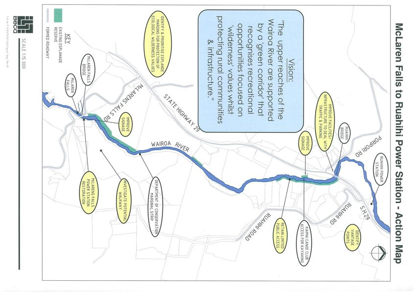
Section Five looks at the local interpretation of the Vision; this includes Local Management Area Visions – which are statements
for key ‘hot spots’ of localised activity along the Wairoa River. Actions have also been prepared for each Local Management
Area – again these identify how to achieve the Vision. Visual interpretation of planning for the future in these areas has been
provided by Action Plan Maps for each Local Management Area.
3.4. Partnership
The WRVS is a Partnership between TCC, WBOPDC, Tangata Whenua and the communities within the strategy area. All partners have
a responsibility for different levels of investment, management and action along the river. Tangata Whenua are sometimes referred to
separately to recognise particular aspirations and responsibilities as outlined in the Treaty of Waitangi /Tiriti o Waitangi. Anyone who
reads this document will have an interest in the Wairoa River and its surrounds and will therefore be included in the definition of
partnership. The strategy gives an integrated approach to the management of resources now, and in the future. The successful
implementation of the WRVS will rely not only on TCC and WBOPDC initiatives but also on a strong sense of ownership and
commitment from the community based on the philosophy of this document. The river valley strategy is only a first step towards better
environmental management.
Wairoa River Valley Strategy October 2013 Page 123.5. The Community
The concept of the Community for the purposes of the WRVS applies to all groups with an interest in the river valley environment. It
includes such groups as Tangata Whenua, Environment Bay of Plenty (BOPRC), landowners, farmers, residents, visitors and developers,
as well as those who visit the river to enjoy its recreational activities.
3.6. Implementing the WRVS
There are a number of methods used to implement and deliver the WRVS. These generally fall into the four categories identified
below:
Voluntary – This is about the community working together and is supported by the concept of partnership.
Research – Generally this will be undertaken by organisations with responsibility in the river valley environment in association
with the local community.
Education – This is about improving the information and knowledge available to the wider community.
Statutory – This includes specific recommendations for changes to statutory planning documents, such as Plan Changes to the
District Plans, Structure Plans, Regional Plans, the TCC and WBOPDC Long-Term Council Community Plans, Asset Management
Plans and changes to By-Laws and other agencies statutory documents. This also includes physical works funded by Councils.
Wairoa River Valley Strategy October 2013 Page 13A number of actions to achieve the Vision of the WRVS have been developed, and priorities have been identified as to the timeframe
in which these should be completed:
Short Term Actions (2006/07 – 2008/09)
Medium Term Actions (2009/10 – 2012/13)
Long Term Actions (2013/14 – 2015/16 and beyond)
Ongoing Actions
Completed Actions
The organisation/group that will be responsible for ‘leading’ the action has been identified for each of the Goals and Actions. This
doesn’t necessarily mean they will be responsible for all of the planning, financial and physical work but more that they will facilitate
and monitor the action to completion. The actions identified have priorities nominated related to the potential significant impacts on
the environment and the ability of the actions to achieve the Vision of the WRVS. A separate implementation plan provides detail on
costings and timeframes for action.
3.7. Delivering the WRVS
The implementation of all the strategy outcomes cannot happen immediately, it is a 10-year programme of on-going work. It is
important to remember the WRVS describes a partnership between the TCC, WBOPDC and the community and the implementation is
the responsibility of all partners. It is intended that the management of the Wairoa River Valley will be able to be undertaken in a more
co-ordinated manner by Councils and other relevant agencies following the guidance of the WRVS. It is important that regular
monitoring of the recommendations is undertaken and reviewed. It is suggested that the following is put in place to guide the
implementation of the strategy to make sure its full potential is realised:
Assign a Council staff member at TCC and WBOPDC to guide the implementation of the WRVS. This could be an Environmental
Officer, Reserves Officer or Policy Planner. They should meet regularly with relevant Council departments (such as reserves,
asset management and engineering).
The responsible Council staff member should meet regularly (at least yearly) with the representative Council staff, Tangata
Whenua and community groups and representatives who were involved in the preparation of the strategy. This will provide
assistance to those groups with identifying gaps in the actions and addressing concerns they may have.
Wairoa River Valley Strategy October 2013 Page 14 The responsible Council staff member should also provide assistance to community groups to prepare a step-by-step plan of all
the Voluntary actions identified in the WRVS of concern to each specific group with timeframes for achieving the actions. This
should also include the identification of any training requirements.
Monitor the implementation of actions. This should be undertaken through the activity planning process and reported as part
of the monitoring cycle for activity planning. The Joint Governance Committee has the responsibility for monitoring the strategy
implementation. (Note that the approach of Councils is to not duplicate any existing committee structures therefore
involvement of Tangata Whenua or any other interested parties would be through either the existing Maori Forum/Collective or
through the approaches outlined above).
The TCC and WBOPDC should sponsor a series of community workshops to actively promote the adoption and implementation
of the WRVS by private organisations and groups, landowners and visitors over the next 10 years.
A review of the actions of the WRVS should be undertaken no later than 10 years following adoption of the strategy. This would
involve making sure updates to LTCCPs, reserve management plans, District Plans and Regional Plans are checked against
WRVS. This will provide the opportunity for new information to be weighed against the Vision and Goals of the WRVS and any
amendments undertaken to reflect this new information. The review should be initiated jointly by TCC and WBOPDC.
Each Council continues development, management and operations within their area with the approaches being aligned with
the Wairoa River Valley Strategy.
Where it is considered there is mutual benefit and opportunities or efficiencies through adopting a joint approach to actions in
the Strategy then this should be considered by the Joint Governance Committee as part of the ongoing monitoring of the
Strategy.
Wairoa River Valley Strategy October 2013 Page 154 Management Themes
What are the Management Themes?
Following background research and information reviews undertaken, discussions with Tangata Whenua, key stakeholders, statutory
agencies, landowners, the local community and the general public, a number of Management Themes for the Wairoa River Valley
were identified. These are considered to be key areas that require work throughout the entire Wairoa River Valley. Each
Management Theme discusses Where We Are Now and highlights some of the key issues that require attention and in response Goals
(What We Want to Achieve) and Actions (What We Will Do) have been prepared for these Management Themes. The Actions have
been prioritised for implementation. These Goals and Actions are important to help Councils and communities make decisions on the
best way to manage the river valley environment in a manner that achieves the Vision of the WRVS.
This section of the WRVS provides details on the Management Themes, which are:
Sustainable Land Use and Development
Quality of the River Environment
Landscape
Cultural Values
Social, Heritage and Community Values
Recreation and Access
Wairoa River Valley Strategy October 2013 Page 16Management Theme 1: Sustainable Land Use and Development Sustainable development can be defined as “Development, which meets the needs of the present without compromising the ability of future generations to meet their needs”.2 This definition then directs us towards thinking about the implications of our actions, both now and in the future, by focussing on the interplay between people and the environment. It requires us to “take a long-term perspective in decision-making processes and to have regard to the social, economic, environmental and cultural dimensions of our decisions”.2 The LGA and thus the strategies that are developed under the LGA, including Tauranga Tomorrow, SmartGrowth and the WRVS represent an important step towards the implementation of sustainable development. There are many different elements that relate to rural and urban land use and development, including highly versatile land, land for business and employment, open spaces, commercial and tourism activities and residential development. The land uses surrounding the Wairoa River are predominantly rural, mainly horticulture and agriculture in the upper reaches, with growing residential development on the city side at the lower end of the Wairoa River and specific areas for residential pockets and lifestyle blocks. Included within this Management Theme is the recognition of the economic importance of the rural sector and commercial activities within the Wairoa River Valley Future to the wider community. Where We Are Now The majority of the land in the upper reaches of the river is zoned ‘Rural’ in the Western Bay of Plenty District Plan and one of the key objectives of the Rural G zone under the Western Bay of Plenty District Plan is the “protection and enhancement of the amentiy provided by the low density character of the rural environment”. The Western Bay of Plenty District Plan in S2.2.1 also refers to sustainable management for a wide range of activities especially primary production and the minimisation of constraints and the potential for conflicts. The river plains, slopes and escarpments of Bethlehem are zoned ‘Rural’ and ‘Rural-Residential’ in the Tauranga District Plan, with limitations on the type, scale and location of activities and buildings, particularly dwellings. In the Western Bay of Plenty sub-region areas of rural land previously used for agriculture or horticulture, such as Bethlehem, have been converted into Residential and Rural-Residential uses.3 This has the effect of reducing the area of large-lot productive land along the Wairoa River Valley. The Tauranga Urban Growth Strategy (1991) identified areas suitable for additional greenfield residential development, including the Bethlehem area. Expansion of the Bethlehem Urban Growth Area into former rural land north of State Highway 2 and east of Bethlehem Road has occurred through the Bethlehem Planning Study (1997). This growth area is developing at a steady rate. There is Wairoa River Valley Strategy October 2013 Page 17
also residential growth occurring through new allotments in the Rural-Residential zone west of Moffat Road/Cambridge Road. These
allotments are not required to connect to wastewater or stormwater reticulation, but to design and construct on-site disposal systems
in accordance with TCC’s Code of Practice or the Regional On-Site Effluent Treatment Plan.

The Western Bay of Plenty District Plan recognises the wider effects that subdivision can have on the environment. Issue 15.1.3 states:
“Subdivision of land to provide for a greater intensity of development may also have the potential to adversely affect the
environment, particularly water and soil values or features recognised as having ecological or other significance to the wider
community”.

What does the future look like?

There are a number of landowners with significant land holdings adjacent to the Wairoa River. For example Bethlehem College owns
a significant land area and has recently prepared a Concept Plan, in conjunction with Keni Piahana, for the future development of
this area (this is discussed further in Local Management Area 4: Bethlehem). Ngati Kahu Hapu has prepared a Concept Plan for the
development and future use of their lands bordering the river and a Private Plan Change to the Tauranga District Plan is currently in
progress as Part B of Plan Change 154.

SmartGrowth (2004) has been adopted by all three local authorities (TCC, WBOPDC and BOPRC) and provides high-level strategic
direction with respect to future land use and development within the Western Bay of Plenty sub-region, specifically for the next 20
years and generally for the next 50 years5. Some indicative land use and development outcomes have been identified in
SmartGrowth. It reveals that the choice of a compact urban form is driven partly by a community-desired outcome that land with
high versatility for production should be retained. According to research and community consultation undertaken during preparation
of the SmartGrowth Strategy, the Western Bay of Plenty sub-region has a shortage of business land. The strategy identified that new
business land is to be progressively developed at each of the identified growth areas to provide local support services and
opportunities for employment to promote the ‘live, work, play’ outcome of SmartGrowth. A sub-regional employment centre may be
developed at eastern Tauriko from 2006. Bethlehem has been identified as an area for commercial retail development, in association
with its relatively recent residential expansion. Bethlehem will continue to develop in line with new zoned land (North West Bethlehem),
existing zoned areas and structure planning. SmartGrowth forecasts that Bethlehem will reach its capacity by 2016. This may have
implications on the Wairoa River Valley because there may be land use conflicts in the future; as land zoned for residential use
becomes pressured and further development becomes more difficult. This may have implications on the land use and development
within the Wairoa River Valley area in the future. The Wairoa River Valley is likely to remain as a rural zoned area as it is a significant
district landscape feature that is to be protected into the future.

Wairoa River Valley Strategy October 2013                         Page 18
One of the key issues identified by SmartGrowth is the lack of energy to sustain the anticipated growth in the Western Bay of Plenty
sub-region. SmartGrowth has identified that there is not enough information to provide a definitive answer to this problem at present.
A report is currently being undertaken into an assessment of alternative energy sources for this area. The Wairoa River is included in this
assessment.

Key issues and opportunities identified through research and consultation

The research and consultation undertaken both prior to and during the development of this strategy has identified that the community
has expressed concerns over land uses adjacent to the tributaries and the effect of this on the quality of the Wairoa River downstream.
Some landowners consider that there are commercial opportunities on land within the Wairoa River Valley and on the water and that
it is important these are facilitated in a sustainable manner. They consider these can be assessed on a case-by-case basis through the
Resource Management Act process. The community has signalled its desire to retain the ‘peace and quiet’, low-density
characteristics of the Wairoa River Valley, by restricting residential sprawl (such as through the conversion of rural land into more
intensive land uses such as greenfield subdivision).

Community consultation also revealed that there is an opportunity to work together and collectively care for the river by undertaking
activities on land responsibly. Examples given were stock fencing, effluent treatment, and more environmentally friendly stormwater
discharges.

Vision for Sustainable Land Use and Development – Where We Want To Be in 2055

“Fostering sustainable land use and development that nurtures the ‘green corridor’ and water
                              values in the Wairoa River Valley”
Opportunities for land use and development that enhances the ‘green corridor’ and water values should be promoted and supported by the
  Councils and wider community. To provide for urban and rural development that is consistent with SmartGrowth principles, particularly in
relation to the protection of highly productive land from more intensive forms of development, and in accordance with Regional and District
                                                       Plans that give effect to this vision.

Wairoa River Valley Strategy October 2013                         Page 19
Management Theme 1: Sustainable Land Use and Development – Action Plan
What We Want To Achieve - Goals What We Will Do - Actions How We Will Do It Priority Who Will Lead It
G1. Increase community awareness that A1. Education Foster Land Care and - Utilise existing and planned environmental programmes Ongoing WBOPDC/TCC
activities undertaken on land directly affect the education programmes in the rural parts of and workshops set up by New Zealand Landcare Trust and
ecological and amenity values of the river the river valley BOPRC BOPRC
valley environment. - Respond to requests by community for establishment of NZ Landcare Trust
landcare groups
- Include education on sustainable land use practices
G2. Support sustainable farm management A2. Voluntary Work with the local - Funding has been provided through the BOPRC Ten Year Ongoing WBOPDC/TCC
techniques. community to support sustainable farm Plan to target the Wairoa River Valley as part of the
management practices Tauranga Harbour Catchment Management Plan BOPRC
- The focus is on sustainable land management and NZ Landcare Trust
biodiversity enhancement and protection works
- A sub catchment action plan is to be completed by
December 2011
G3. Recognise that there is potential in the A3. Statutory Investigate options for a Develop a policy on the concession approach to be taken. Short WBOPDC (lead) and
future for impacts on the Wairoa River in from consistent approach to concessions for the TCC
land use for recreational activities (both recreational use (commercial and non- To be a joint approach with TCC, WBOPDC & BOPRC
commercial and non-commercial) commercial) of the water and adjoining based on any transfer of power that exists, etc. (within existing policy
reserves. development budgets)
Wairoa River Valley Strategy October 2013 Page 20Management Theme 2: Quality of the River Environment The Wairoa River Valley has a dominant rural character, which retains elements and features of ecological significance, of which the Wairoa River itself forms an important ecological corridor between the Tauranga Harbour, its upstream environs and the Kaimai Ranges.1 The Wairoa River contributes about 50% of the total inflow of freshwater to the Tauranga Harbour. There are a number of tributaries flowing into the Wairoa River. The Wairoa River Valley environment provides a valuable habitat for fish, insects, birds and a range of other animals and plants endemic to New Zealand. There is a range of physical factors operating where the Wairoa River meets the Tauranga harbour, in particular high tides, strong offshore winds and the potential for storm surge at the river mouth. For the purposes of the WRVS, the ‘quality of the river environment’ relates to the quality of the water and the quality of the land adjacent to the river as it relates to biodiversity, and this includes vegetation. In this definition it is recognised that the quality of the water is reliant on a healthy river margin. Where We Are Now The 2004 Tauranga State of the Environment Report by TCC notes that only about 3% of stream margins (14.48km) in Tauranga are of Category 1 ecological significance (these are the most significant ecological sites) and the Wairoa River is one of these sites.3 Approximately two-thirds of stream margins are in a degraded state requiring restoration and there is potential for considerable restoration of riparian areas. Healthy stream margins protect fish life by providing shade, filtering runoff and reducing human access, and often provided valuable links between one habitat and another. Flora and Fauna The Wairoa River catchment is the southern most extent of the natural range of Kauri. Vegetation along most of the length of the river valley is in the form of small pockets of native river and estuarine plants. The lower banks tend to be rural grassland to the bank edge. The river and its estuary contain sites of district and regional significance (in terms of botanical conservation) and important habitats for wildlife and all of these sites have been given recognition in regional and district planning documents to afford some degree of protection. A pristine condition marshland and other quality habitat exist at the northern harbour reaches of the river. These have been identified in the Department of Conservation report ‘Protection and Restoration of Marshbird Habitat in the Tauranga Harbour, 1993’. Estuarine Wairoa River Valley Strategy October 2013 Page 21
wetlands form an important component of the ecology of the lower Wairoa River Valley and the estuarine wetlands are known for
their vegetation and bird life. The Wairoa estuary supports not only the more common species of marsh bird but also those that are at
considerable risk from extinction (e.g. bittern). Freshwater streams and rivers (including their mouths) have been identified as being
‘Highly Significant’ for Protection.6 Using a comprehensive evaluation technique, the condition of each of Tauranga’s most significant
ecological sites (Category 1 sites) has been assessed and this is documented in the 2004 Tauranga State of the Environment Report.
The Wairoa River is identified as having Category 1 ecological significance, though its condition is considered to be declining.

The Wairoa River and its tributaries are home to significant freshwater fish habitats including the short-jawed kokopu and the giant
kokopu. Whitebait spawning grounds have been identified along the Wairoa River by Department of Conservation as well as a
number of other significant habitats for native species that are endemic to New Zealand. Parts of some of the tributaries remain
relatively unmodified, including the Ohourere and Ngamuwahine streams. A NIWA report was prepared in February 2000, which
compiled an inventory of wetland plants and birds in the lower reaches of the Wairoa River. The report noted that Tauranga Harbour
is an area of international significance for at least seven species of shorebirds. Within the lower reaches of the Wairoa River the bird
community is dominated by species, which are widespread in modified shrubland throughout New Zealand, though there are two
wetland birds of conservation concern, being the Australasian Bittern and Fernbird.

Sediment

The Wairoa River intermittently carries very high volumes of floodwater, sediment and debris of numerous forms, and as a
consequence the low-lying floodplains downstream are susceptible to flooding.7 BOPRC has undertaken assessments of the sources
of sediment in the Wairoa River. BOPRC considers that because the Wairoa River is almost completely diverted through the Ruahihi
power scheme, under normal flow conditions, sediments in the water are low at the Ruahihi site because of settling in the hydro-lakes.8
From the Ruahihi site to the harbour the Wairoa River has a small gradient and is relatively
wide, hence little riverbank erosion is caused by the slow flow. This alters dramatically at times
of high flood and when agitation is increased by wind action of speeding powerboats. The
bulk of sediments in the river are thought to originate through some of the main tributaries.
Although it is not indicated whether these are the tributaries entering the Wairoa River below
the Ruahihi Power Station. NIWA prepared a report in 2000 that addressed the sediments in
the lower Wairoa River and identified that “none of the cores contained any evidence of a
layer of Ruahihi mud. We might have expected such a layer to be deposited in the estuary
channel following the collapse of the headrace channel of the Ruahihi Power Station in 1981.
The lack of a mud layer and the generally low mud content of suficial sediments suggest that

Wairoa River Valley Strategy October 2013                       Page 22
tidal currents and waves have the ability to rework and transport mud away from the embayment”.9
BOPRC has estimated works required for the Wairoa River from Ruahihi to the river mouth for “ideal” catchment management
includes planting and fencing of 6km length total and some occasional vegetation clearance. In the lower reaches of the river,
BOPRC suggests that the erosion of the riverbanks is to some extent from watercraft speeding.
Water Quality
BOPRC currently measures the water quality of the Wairoa River at three sampling stations, these are McLaren Falls, State Highway 29
bridge (Ruahihi Power Station) and at State Highway 2 bridge (Wairoa).
A report completed in 2004 by BOPRC contains information on bathing beach grading.10 The objective of the report was to provide
an interim grade based on the ‘Microbiological Water Quality Guidelines for Marine and Freshwaters, 2003’ for many of the Bay of
Plenty’s most popular and higher risk recreational waters. Beach grades are designed to gauge the general health of beaches
(marine or freshwater). There were two points in the Wairoa River where water quality was tested for the purpose of the beach
grading report, being downstream of McLaren Falls in the WBOP District, and Bethlehem in Tauranga City. The water quality below
McLaren Falls dam was rated ‘poor’ which means that the site receives run-off from one or more sources containing animal or human
faecal material. Water with ‘poor’ quality is generally not suitable for swimming. According to the report swimming should be
avoided. Permanent warning signs may be erected at these sites, although BOPRC may monitor these sites weekly and post
temporary warnings. The water quality at the Bethlehem monitoring site was rated ‘very poor’ and it is recommended that “swimming
should be avoided as there are direct discharges of faecal material and permanent signage should be erected”.10 This kind of site
receives run-off from one or more of the following sources and may contain animal or human faecal material:
Untreated/primary/secondary treated wastewater
On-site waste treatment systems
Urban stormwater, intensive agriculture, unrestricted stock access, dense bird populations
River discharges containing untreated/primary/secondary treated wastewater or on-site waste treatment systems.
An important point to note is that the water quality grades presented in the report are interim, as macrobiological data has not
reached an optimum level to be statistically robust according to the 2003 guidelines.2 BOPRC have not identified when this
2The Ministry for the Environment together with the Ministry of Health released a guideline for monitoring recreational water quality in 1999. These guidelines have been
subsequently been developed further with input from Regional Councils, territorial local authorities and public health agencies. The latest guideline, ‘Microbiological Water
Wairoa River Valley Strategy October 2013 Page 23information will be confirmed. However, most of the data does provide useful information to allow an assessment of perceived risk to
users of recreational waters.
In summary, there is evidence to suggest that the quality of the Wairoa River environment is particularly unstable and of a poor quality.
There are activities occurring on land and discharges to the river that are contaminating the river for swimming, particularly in the
lower reaches. This is an opinion that was shared by many landowners and members of the community during consultation for the
WRVS. The particular issues and opportunities raised with respect to water quality are listed below.
Key issues and opportunities identified through research and consultation
Background research and consultation undertaken with the community both previously and during this project has identified that the
key concern over the quality of the environment is the quality of the water of Wairoa River at present. There was agreement by the
community that steps need to be taken to make sure that a baseline water quality is established and also that any improvements in
water quality are maintained. There are suggestions from some members of the community that esplanade reserves should be fenced
from stock grazing but then weed control issues would need addressing. The community would like to see any future riverside
walkways appropriately planted to protect riparian margins and thus the quality of the water.
Vision for Quality of the River Environment - Where We Want To Be in 2055
“The Wairoa River Valley environment is symbolised by the river and its
surrounds that are maintained and enhanced for future generations by
sustainable land use”.
The community considers that there is a need to improve the quality of the Wairoa River. The vision for the Quality of the
Wairoa River Environment will include improving the water quality, improving riparian margins and improving the biodiversity
of native flora and fauna. The responsibility for this lies with a number of groups, including (but not limited to) landowners and
river users, along with assistance from various councils and other agencies.
Quality Guidelines for Marine Freshwaters, 2003’ aims to establish national consistency in recreational water quality and to protect the public when there is a health risk
concerning microbiological contamination.
Wairoa River Valley Strategy October 2013 Page 24Management Theme 2: Quality of the River Environment – Action Plan
What We Want To Achieve - Goals What We Will Do - Actions How We Will Do It Priority Who Will Lead It
G1. Enhance the water quality of the Wairoa A1. Statutory As a condition of subdivision - City Plan and District Plan have provisions relating to Ongoing TCC, WBOPDC,
River through improved riparian margins. consent for all land adjacent to the Wairoa earthworks, height of native vegetation, building height, BOPRC, NZLT
River require riparian margin planting to assist building setback, earthworks and reflectively.
in the buffering of the river from point and - reserve management plans to address riparian planting on
diffuse discharges as well as buffering of public land
riverbank erosion. - landcare and environmental programmes
A2. Statutory Undertake rubbish debris - If this is a navigational hazard, this will occur as part of the Ongoing BOPRC
clearance of the river mouth. responsibilities of BOPRC Maritime.
A3. Voluntary Look at ways to decrease - Work with the community to identify how this can be Ongoing TCC, WBOPDC,
sedimentation of this area. achieved and/or consider as part of work undertaken in the BOPRC
area
G2. Manage land use and subdivision A4. Statutory Review criteria for the quality of - If required - Plan Changes to Regional Plans to rules for Short BOPRC
surrounding the Wairoa River to reduce the stormwater discharge into the Wairoa River discharges adjacent to the Wairoa River.
level of contaminants entering the river. and through to the Tauranga Harbour to
determine if there are issues with application
of this.
G3. Improve knowledge of, and appreciation of A5. Research Support ongoing research and - Identify timing and funding for ongoing research and Medium WBOPDC
ecological values important to the Wairoa monitoring of ecological values within the monitoring.
River Valley. Wairoa River Valley.
G4. Improve the public knowledge of the water A6. Research To continue the ongoing - Review the effectiveness of indicators for water quality for BOPRC
quality within the Wairoa River. monitoring of the water quality in the Wairoa the Wairoa River eg bathing statistics report Ongoing
River (and the impacts on the Tauranga - Present the updated information to the community as
Harbour), review this information and provide appropriate.
feedback to the community.
A7. Education Work closely with landowners Note that BOPRC assistance could be provided in terms of Ongoing TCC/WBOPDC
to mitigate effects of inappropriate septic tank information and pollution prevention.
use.
G5. Recognise the importance of biodiversity A8. Research To recognise the importance of - Include the Wairoa River Valley in the Operational Short - TCC/WBOPDC
to retain and enhance the ‘green corridor’ and the Wairoa River Valley in the development of Management Strategy for Biodiversity. Medium
Wairoa River. strategies for biodiversity. - Approach BOPRC if required to consider this request.
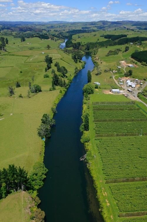
Wairoa River Valley Strategy October 2013 Page 25Management Theme 3: Landscape Tangata Whenua has provided the following perspective of the landscape of the Wairoa River Valley. “The Wairoa River is approximately 14 kilometres in length and the largest freshwater tributary to Tauranga harbour. The Wairoa River is a broad river, with rapids at its source that traverse the incline of the Kaimais, generally known as the Upper Wairoa River. The lower Wairoa meanders through alluvial plains forming estuarine flat plains of low elevation. The river flows in a northeasterly direction from the water catchment of the Kaimai to the harbour between Te Puna and Bethlehem. The main tributaries of the Wairoa include Mangakarengorengo, Opuaki, Maungapapa, Omanawa below Ruahihi, and Ruanganrara (Ohourere). The streams are deeply incised into the plateau and are characterised by easy gradients and numerous waterfalls. Base flows are higher because of the spring-fed nature of the streams.” The landscape character of the Wairoa River Valley includes both the natural values and the values associated with the human interaction with the river and its environment. The landscape is dominated by the Mamaku plateau with its gently sloping top and steep, deeply incised stream channels. Below the Mamaku plateau the countryside grades down to a sequence of broken and isolated terraces and eventually to the flats and rushlands of the estuarine environment.11 When approaching the city from State highway 2 the Wairoa River Valley is considered to be one of the ‘gateways’ to Tauranga city. An important component of the landscape character of the Wairoa River Valley is also the human landscape that includes the large farm blocks, residential settlements, infrastructure and other built structures. The Wairoa River Valley is identified as a significant district landscape feature in the Tauranga District plan (Chapter 4). The Tauranga SOE 2004 identifies the Wairoa River as an important natural landscape of Tauranga and the whole of the Wairoa River as having high visual amenity. The report indicates that landscape value benchmarked in 1999 in regards to general views and our harbour has declined slightly, while bush and trees has improved slightly. Where We Are Now Cultural Landscape The Wairoa River and its landscape/visual context are of particular significance to Tangata Whenua. Maori names have been attached to all the main landscape features and in the more closely settled areas, every small turn of the river and the hills12. The close association Tangata Whenua has with the Wairoa River Valley has resulted in certain features having particular symbolic meaning and Wairoa River Valley Strategy October 2013 Page 26
sacredness associated with events in the past history of the tribes. The Wairoa River is a substantial part of the ancestral landscape and the preservation of the natural and physical character of the area is crucial in sustaining district natural character, cultural and spiritual links and aesthetics (among other factors).11 This is discussed further in Management Theme 3: Cultural Values. Landscape Assessments A landscape study has divided Tauranga City into a number of landscape types and character areas. The Wairoa River was identified as an ‘Outstanding Natural Feature and Landscape Feature’ and this became the statutory basis for the landscape values in the Tauranga District Plan and the Western Bay of Plenty District Plan for the Wairoa River. This classification is based on the landscape, hydrological, botanical and habitat values that make the Wairoa River Valley a special place for the communities of the Western Bay of Plenty. The Bay of Plenty Regional Coastal Environment Plan identifies the whole of the Tauranga Harbour, including its estuarine fringe as an ‘Outstanding Natural Feature and Landscape’ and this includes the mouth of the Wairoa River. The protection of these landscapes and natural features is a shared responsibility between BOPRC and the district and city councils. A landscape and ecological assessment undertaken of the Bethlehem/Wairoa area in 1997 as a background for the Proposed Tauranga District Plan identifies the lower reaches of the Wairoa River as contained within a well- defined channel, with a river bank of some few metres in height above the surface of the water.13 The assessment defines the valley as formed by river flats and harbour plains (0-3 slope) that consist of poorly drained flats with a moderately high water table, subject to run-off from the adjacent higher areas. The slopes of the valley margin are described as rolling to strongly rolling with free-draining soils (8-20 slope) mainly in pasture and horticulture and with escarpments generally managed as woodlots running up to the plateau. This plateau of the valley is identified as containing mainly shelterbelts and used for a range of horticultural activities and urban land use. The upper reaches of the Wairoa River from McLaren Falls flows through a mixture of pastoral and forested lands characterised by steep gorges in places. The margins of the upper reaches are characterised by steep rock drop offs and bush covered plateau. Today’s Landscape The open river valley, slopes and escarpments visible from the river itself provide a visual transition between the intensively developed urban environment of Tauranga and the rural environment of the Western Bay of Plenty District. 4 This is recognised by the ‘Rural’ Wairoa River Valley Strategy October 2013 Page 27
You can also read