WATER QUALITY AND QUANTITY - Horizons Regional Council
←
→
Page content transcription
If your browser does not render page correctly, please read the page content below
WATER QUALITY AND QUANTITY
1       ACTIVITY OVERVIEW
The Water Quality and Quantity Activity of the Annual Plan includes the work programmes of
Horizons’ Freshwater & Partnerships Team and the Science and Innovation Team.

Horizons’ Freshwater & Partnerships Team works closely with other Horizons teams, and
people external to the organisation, to implement water quality and aquatic habitat
improvement works. This work draws on monitoring and research undertaken by Horizons’
Science and Innovation, and Environmental Data teams, along with that of other agencies, to
prioritise and focus implementation efforts.
Both programmes actively seek funding from other sources, to provide external science advice
and facilitate the acceleration of works. This includes the Freshwater Improvement Fund
(FIF) for the Manawatū, Whangaehu and Lake Waipu/Rātana Catchments, Public
Waterways Ecosystem Restoration (PWER) for the Regional Stream Fencing and Riparian
Planting programme, and Enhancing Fish Populations through Fish Barrier Remediation, and
the Community Environmental Fund for the Waikawa Catchment. These are all administered
through the Ministry for the Environment (MfE). Funding of science advice through the
Ministry of Innovation, Business and Employment’s (MBIE) Envirolink fund totals
approximately $120,000 per annum.

Implementation activities include riparian fencing and planting for water quality improvement
and fish habitat enhancement, identification and enhancement of whitebait spawning habitat
and fish passage improvement, sewage treatment plant upgrades, work with horticulture
growers, and harvesting of lake weed.
Science activities include monitoring and reporting of water quantity for both surface water
and groundwater, and the quality of groundwater, rivers, lakes, estuaries, and the coast. More
than 80 popular swim spots are monitored weekly throughout the bathing season (November –
April). In addition to guiding implementation programmes, science and research also informs
consent decision-making, and policy development and implementation. Communication of
science data and information is primarily covered in the Environmental Reporting and Air
Quality Monitoring section of this report.

This item presents the Water Quality and Quantity Activity regionally (where appropriate)
and/or for each of the Freshwater Management Units (FMUs) that make up the Manawatū-
Whanganui region, integrating the implementation work of the Freshwater & Partnerships
Team, and the water quality and quantity activities of the Science and Innovation and
Environmental Data teams. This includes the:

Regional Water Quality and Quantity Programme;
Whanganui & Kai Iwi;
Whangaehu – including the Whangaehu FIF projects;
Rangitīkei-Turakina – including the Lake Waipu (Rātana) FIF project;
Manawatū – including the Manawatū River Accord and FIF project;
Waiopehu – including the Lake Horowhenua Accord and FIF project, as well as freshwater
improvement work with horticulture growers; and
Puketoi ki Tai – coastal Tararua area.
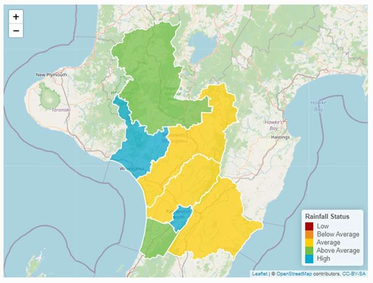
Figure 1: Freshwater Management Units in the Horizons Region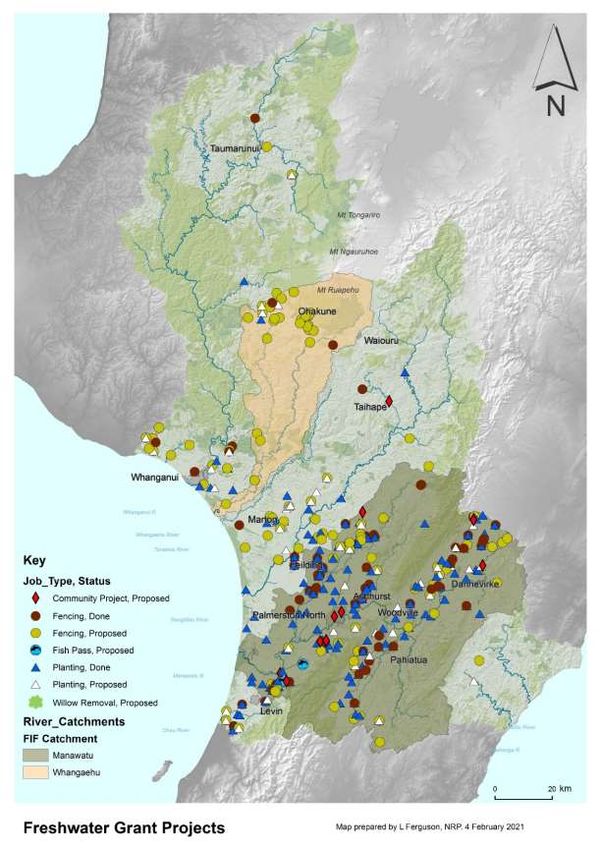
2 REGIONAL WATER QUALITY AND QUANTITY
PROGRAMME
2.1 Regional Freshwater & Partnerships Overview
PROGRESS AGAINST ANNUAL PLAN TARGETS
2.1.1 The Freshwater & Partnerships programme links with a range of national and regional
policies and strategies. The programme aims to deliver freshwater enhancement work
in partnership with others to improve water quality and aquatic health outcomes, and
to facilitate community involvement. Some of the work also informs restoration
options and seeks to build capacity. The programme delivers work across six key
components, each of which includes funding from Central Government:
Regional freshwater programme, outside the Manawatū and Whangaehu
Catchments (includes the Jobs for Nature stream fencing and riparian planting
programme);
Manawatū Accord and Freshwater Improvement Fund project;
Whangaehu Catchment Freshwater Improvement Fund project;
Enhancing fish populations through fish barrier remediation Jobs for Nature
project;
Waipu Catchment Freshwater Improvement Fund project to remove the Rātana
waste water treatment plant (WWTP) discharge from Lake Waipu and irrigate
to land while also developing a restoration plan for Lake Waipu; and
Lake Horowhenua Accord and Lake Horowhenua Jobs for Nature project.
2.1.2 A summary of progress against Annual Plan targets is presented in this section of the
report, and project updates on specific works are presented in the relevant FMU
summary.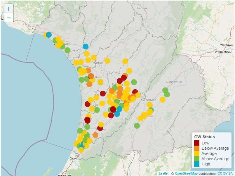
Table 1: Freshwater & Partnership s programme progress on the 2020 -21 Annual Plan
targets as at 31 December 2020.

                          Riparian fencing (km)                            Riparian planting
                Target   Allocated   Complete         %       Target     Allocated    Complete       %
                                                   complete                                       complete

    Regional     12        2.540      2.316         84%1       20,000     14,905       15,241      149%
    Jobs for     35       38.041      7.774         22%        35,000     27,185       14,642       42%
    Nature2
    Manawatū     50         97.5       49.6        99.2%       40,000    114,500       90,802      227%
    Whangaehu    17        40.35      .1480          1%        3,333       3,987       2,023        61%
    Total3       102       178.4      59.84                    78,333    160,577      122,708      156%
                                     Fish passes                                 Community projects
                Target   Allocated   Complete         %       Target     Allocated    Complete       %
                                                   complete                                       complete

    Regional      1          0           0           0%          1           1            1        100%
    Jobs for      5          0           0           0%         n/a         n/a          n/a        n/a
    Nature
    Manawatū      4          3           0           0%          9          12            2         22%
    Whangaehu     2          0           0           0%          3           8            0         0%
    Total3
                  7          0           0                       13         21            3         23%

1
    % is based on works completed in both the Regional and Jobs for Nature programmes.
2
 Currently not an annual plan target however, both the Regional and Jobs for Nature projects
count towards the Annual Plan targets for the Regional Freshwater Programme.
3NB: The totals in these target tables represent an overall total and achieving these totals does not
necessarily mean all targets have been met, as it is the individual targets that are in the Annual Plan.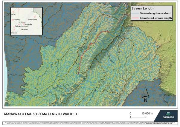
Figure 2: Freshwater implementation projects for stream fencing, riparian planting,
community proje cts, and fish passes for the 2020-21 financial year (as at 31 December
2020).
JOBS FOR NATURE PROJECTS
2.1.3 In July 2020 Council resolved to enter into three Jobs for Nature “Quick-start”
projects. These projects are funded through the broad Jobs for Nature Fund, and more
specifically are referred to by the Ministry for the Environment as Public Waterway
Ecosystem Restoration Fund projects.
2.1.4 The Deeds of Funding for the Stream Fencing and Riparian Planting programme, and
enhancing fish populations through fish barrier remediation have been signed and the
first meetings of the Governance Groups occurred in October 2020.
2.1.5 During the reporting period the following positions were added to the team as a result
of the additional funding:
Three Freshwater Advisors (2.5 FTEs) started in October 2020 for the Regional
Stream Fencing and Riparian Planting programme. Additional winter staff
recruitment is underway for two fixed term positions (6 months), with a proposed
start date of April;
The Fish Passage Coordinator (Tessa Stevens) joined us in October 2020;
Four research assistants on fixed four-year contracts joined us in October and
November 2020 with three summer students also starting at the same time. An
additional 12-week contract is currently being recruited for the Fish Passage
team;
Advertising has commenced for the Freshwater Coordinator – Lake Horowhenua
position.
ENHANCING FISH POPULATIONS THROUGH FISH BARRIER REMEDIATION
2.1.6 This project commenced at the beginning of October and is well underway within the
two focus catchments – Ōhau and Waikawa. The Fish Passage team consists of eight
members but dropped to five when the summer student 12-week contracts ended at
the beginning of February 2021. A fourth 12-week contract was being advertised.
2.1.7 This four-year project has just completed quarter 2 of year 1 and overall is on schedule
to achieve the deliverables prior to the end of the first project and financial year. Key
focus areas for the team have been: stream walking (to assess barriers to fish
migration), monitoring of fish and kakahi populations, and remediation of identified
barriers. Stream walking in the two focus catchments has been progressing well, but
with some difficulty due to the areas containing numerous lifestyle properties. This
makes landowners more difficult to contact and without permissions, certain sections of
river/ stream have not been assessed. Letter drops and cold calling attempts continue
to be made in these focus catchments. In addition to this, the team have progressed
with certain catchments in the Manawatū where landowner permissions are more
readily available.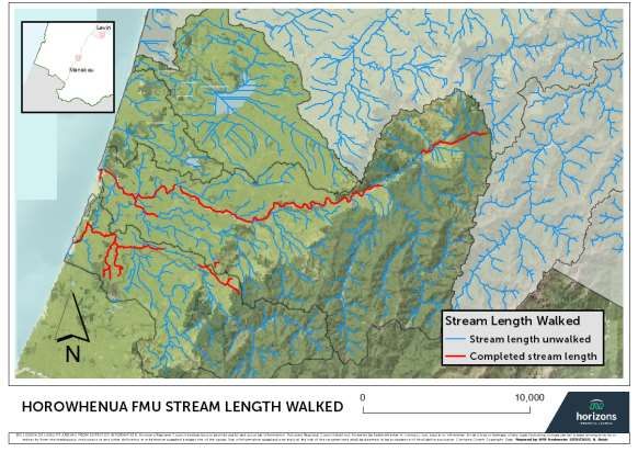
Figure 3: Stream length walked in Ōhau and Waikawa Catchments.

Figure 4: Stream length wal ked i n Manawatū Catchment.

2.1.8
2.1.9 Fish and kākahi (freshwater mussel) monitoring has been progressing well with seven
       fishing sites and four kakahi sites completed. A report is to be commissioned on the
       current state of the region’s fish and kakahi populations through Massey University,
       with scoping of the project underway.

Figure 5: Top left and right: Kakahi surveys in the Tararua area (both sites had kakahi
present). Bottom left: Fyke net traini ng survey in the Purua Stream, Whanganui. Bottom
right: A giant kokopu found during the survey.

2.1.10 The project has a target of five sites this year for barrier remediation. At the time of
       reporting, one was complete with the remaining four scheduled for completion during
       February 2021.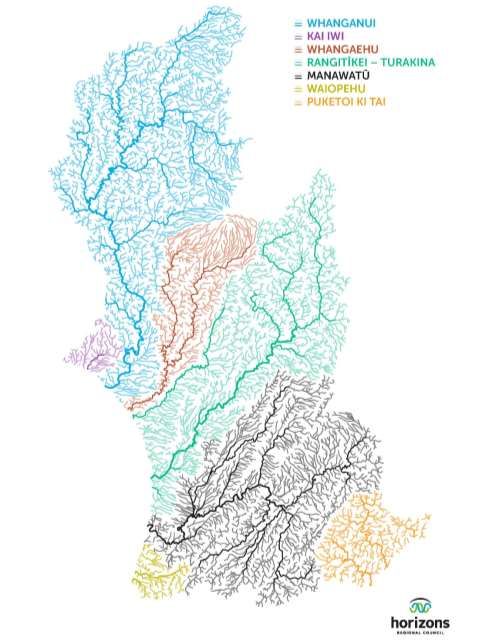
Figure 6: Fish barrier remediated in a tributary of the Waikawa Stream. Photo on the left
shows prior to remediation (a drop due to a wooden board covering entrance to culvert)
and photo on the right after remediation by removing the board.
2.2 Regional Water Quality & Quantity Science Programme
Overview
MONITORING PROGRAMMES
2.2.1 Water quality and quantity monitoring is overseen by Horizons Science & Innovation
team, but delivered in partnership with the Environmental Data, Consents Monitoring
and Freshwater & Partnerships teams. Much of this activity focusses on improving
knowledge and understanding of the region’s freshwater and coastal environments by
monitoring the state of the environment, tracking changes over time, and identifying
areas of emerging pressure. Water quantity, quality monitoring, and biomonitoring
programmes encompass:
River flow at 65 sites, groundwater levels at 192 sites, and measurement of water
use at more than 350 sites across the region;
River water quality at 90 state of environment sites, 32 discharges and 52 sites
located upstream and downstream of discharges;
Water quality at four coastal and seven estuary sites, and ecological condition
and/or sedimentation of five estuaries;
Groundwater quality at 35 sites;
Water quality in 17 lakes and submerged plants in approximately eight lakes
annually;
82 popular swim spots throughout the bathing season (November to April);
Macroinvertebrates at 95 sites and periphyton at 63 sites.
2.2.2 The monitoring network is undergoing a review in response to national policy
requirements, and to better inform decision-making and implementation programmes.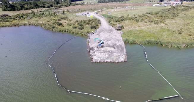
State of the regional water resource
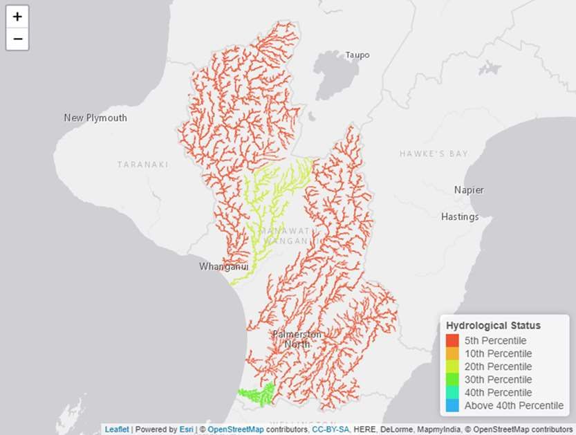
2.2.3 Spring was warm and wet for much of New Zealand, and particularly for the Horizons
Region. It signalled a turnaround from low winter rainfall, with spring and early
summer rainfall at average or above average throughout much of the region, and
particularly on the western side of the ranges. Average conditions for each site were
benchmarked over the length of record for each site, at least 20 years in most cases.
Figure 7 Hydrological status as determined by rainfall quantities over the preceding four
months at 10 representative sites, February 2021 .
2.2.4 This spring rainfall increased groundwater levels across the region, enabling further
support of river levels during summer low flows. Prior to Christmas, approximately
50% of the bores Horizons monitors monthly for water levels were either low or below
average. By February 2021 this had dropped to about 20% of monitored bores (Figure
8), with low groundwater levels persisting in the rural Manawatū area.Figure 8: Groundwater level status as determined by monthly monitoring at 13 0 bores,
January 2021.
2.2.5 As outlined above, the warm relatively wet spring had river flows follow a more
‘typical’ summer pattern, with low flows occurring later in the season. Low flows have
started to occur at a few sites, but overall river flow status is currently ‘average’,
based on long-term records for the last 20 years at 11 key flow monitoring sites.
Figure 10 shows the river flow status as at 10 February 2021 compared to the same
date in 2020.Figure 9: Hydrological status as determined by river flow over the preceding four months at 11 representative si tes, February 2021 (top image), compared to the same date in 2020 (bottom image).
2.2.6 There were few low flow restrictions across the region for most of the summer to date.
        Some municipal water supplies have recently been required to limit or step-down
        abstractions as river flows began to decrease. As at 15 February, there are 39 consent
        holders experiencing some level of low flow restriction, across 14 flow monitoring
        sites. A number of sites were nearing low flow restriction levels. This pattern is
        expected for this time of the year.

 2.2.7 The telemetered water use programme continues, with the programme of annual
        inspections is progressing well. A key challenge for this programme is access to
        communications in certain areas of the region and the team has made good progress
        in resolving a number of these issues. Cell-phone reception issues have been able to
        be resolved in some areas with the adoption of new technology to overcome the
        shortfall in signal in difficult terrain.

        LAKES MONITORING
 2.2.8 State of Environment (SOE) monitoring of lakes in the region has recently
        expanded to include monthly sampling of Hokowhitu Lagoon, commencing in
        November 2020, and Lake Papaitonga, commencing in December 2020. Hokowhitu
        Lagoon is a shallow riverine (oxbow) lake adjacent to the Manawatū River in
        Palmerston North which is popular for public recreation including picnicking, walking,
        fishing, kayaking and canoe polo. Lake Papaitonga (Waiwiri) is a shallow coastal dune
        lake situated just south of Lake Horowhenua. A scenic reserve with a walking path
        borders the lake and is managed by the Department of Conservation. These lakes
        were added to the SoE monitoring programme because of their public access and
        representative lake type in their respective catchments. This is a further step in
        meeting the requirement under the 2020 National Policy Statement for
        Freshwater Management (NPS-FM) for regional councils to monitor a set of lake
        sites that adequately represent each of the regions’ Freshwater Management Units
        (FMUs). Further recommendations to work toward this requirement have been
        proposed in the Long-term Plan.

2.2.9   Annual assessments for Lake Submerged Plant Indicators (LakeSPI) of ecological
        condition were carried out by NIWA for eight lakes in December 2020, six of which had
        been previously assessed, namely: Lake Dudding (2001, 2015), Pukepuke Lagoon
        (2001 and 2015), Lake Wiritoa (2001 and 2015), Lake Pauri (2015), Lake Alice (2015)
        and Lake Namunamu (2016). Two – Hokowhitu Lagoon in Palmerston North and Lake
        Virginia in Whanganui – were assessed for the first time. The results and report will be
        completed later in the year. This monitoring will inform assessment of lake state
        against new water quality attributes required under the
        2020 National Policy Statement for Freshwater Management (NPS-FM).
2.2.10 Microplastics are among contaminants of emerging concern for aquatic systems. The
Global Lake Ecological Observatory Network (GLEON) has begun a study named
Global Lake Microplastics (GALACTIC), and Horizons has participated by sampling
Lake Wiritoa and Lake Pauri in November 2020. The objective is to sample lakes
worldwide to identify the occurrence of microplastics in surface water of different
freshwater systems based on watershed and lake features (land-use, population,
catchment area, etc.). Samples were sent to the University of Milano-Bicocca in Italy
for processing free of charge. This will lead to a collective research paper, helping to
advance global research around microplastics in freshwater systems.
ESTUARY ECOLOGICAL CONDITION MONITORING
2.2.11 Ecological condition and/or sedimentation monitoring of five estuaries was conducted
by Salt Ecology in December 2020. Preliminary results showed that both the Waikawa
and Ōhau systems had been well flushed by recent flooding at the time of sampling.
The Waikawa in particular had less bottom waters with depleted dissolved oxygen than
12 months previously, but there are still obvious nutrient enrichment problems. The
Ōhau estuary looked to be in good condition. There were also a few notable changes
in the other estuaries monitored. Manawatū Estuary showed around 20 mm of
sediment erosion at the monitoring sites. In contrast, Whanganui Estuary showed a
build-up of sediment (accretion). The Whangaehu Estuary sediment results were quite
variable. All the sites appear to be telling a story vividly showing how dynamic the
estuaries are.
2.2.12 Full results and reports will be completed in June 2021 and this will include
considerations for future monitoring.
CONTACT RECREATION WATER QUALITY MONITORING
2.2.13 Monitoring of more than 80 popular swim spots around the region began on
1 November 2020. The programme is delivered in collaboration with MidCentral Public
Health Service, local councils and Ngā Waihua o Paerangi Trust. Monitoring results are
reported weekly, as they become available, via both Horizons
(http://www.horizons.govt.nz) and the LAWA (http://www.LAWA.org.nz) websites.
2.2.14 Results to date have been variable. In general, beaches sampled across the region
have been mostly swimmable with a few exceedances at times. Further re-samples on
these occasions (in line with recreational guidelines) have not warranted any beach
closures and have to date returned results within the guideline values for
swimmability. River sites have, on occasion, exceeded recreational guidelines for both
E. coli and potentially toxic algae thresholds across the region. The Mangatainoka
River, in particular, has been graded unsuitable for swimming at times due to
potentially toxic algae levels.2.2.15 The Kaikokopu Stream has had cautionary signage erected by public health due to a
high reading of E.coli (14,100 MPN/100mL, and a follow-up result of 798 MPN/100mL
(NB levels higher than 540 MPN/100mL is deemed unsuitable for swimming) directly
prior to the Himitangi Big Dig weekend. It was anticipated the signage would be
removed in the short term, depending on results.
2.2.16 Faecal source tracking is planned for four streams in late February 2021 (delayed from
the 2019-20 season by COVID-19) as part of the programme. These include
Kaikokopu Stream at Himitangi Beach, as well as Wairarawa Stream at Waitarere
Beach, Wainui Stream at Herbertville and the Ōngarue at Cherry Grove monitoring
site.
2.2.17 Whanganui lakes Wiritoa and Pauri have been suitable for swimming for much of the
season to date. Potentially toxic algae monitoring was added to Hokowhitu Lagoon this
season, and aside from a brief exceedance over the New Year period the levels were
either amber or green (caution advised and suitable for swimming, respectively).
2.2.18 Lake Dudding was deemed unsuitable for swimming and warning signs erected
between 16 November 2020 and 21 January 2021 due to high bio-volumes of
potentially toxic algae. The closure at Lake Dudding this season has been longer than
the closure in the 2019-20 season. The poor ecological health of the lake is
highlighted in a recent report titiled Duddings Lake by Gibbs et al. (2020) which
outlines restoration options for the lake recommended by an expert panel following a
workshop held in May 2019.
2.2.19 Figure 9 below shows the most recent contact recreation results displayed on LAWA
and the Horizons website for Lake Dudding. It shows the site to be at amber alert due
to elevated bio volumes of cyanobacteria. Lake Dudding has a long-term grade of poor
based on five years of sampling.Figure 9 Screenshot of results for Lake Dudding on the LAWA site for the week of
9 February 2021
ENVIRONMENTAL DNA FISH MONITORING PROJECT
2.2.20 The Science and Innovation team is supporting sector-wide and regionally specific
development of Environmental DNA (eDNA) tools for fish monitoring; eDNA is DNA
that is isolated from an environmental sample, such as water or soil, rather than from
the individual specimen itself. Living organisms constantly lose a stream of genetic
material, through the loss of skin cells, scales, hair, excretion of slime, faecal material,
reproductive material or other forms of living matter. By collecting DNA from the
environment, in many cases we can work out what species are living within that
environment, with some caveats.
2.2.21 The use of these tools for fish monitoring, and likely a range of other monitoring
programmes, is expected to result in significant efficiency gain in staff time, cost and
potentially increased power to detect species and characterise communities.
Compared to the cost of traditional fish monitoring, eDNA is relative quick, simple and
low cost. It is, however, a relatively new technique in New Zealand and given the
many benefits of eDNA sampling, it is currently being investigated by most regional
councils or unitary authorities, as well as Central Government organisations such as
the Department of Conservation, and was the subject of a recent Envirolink tools
project titled Molecular tools for characterising freshwater fish communities in New
Zealand (Banks J, Kelly L, and Clapcott J, 2020). Prepared for Ministry of Business,
Innovation and the Environment, Envirolink CAWX1802. Cawthron Report No. 3573.
66 pp. plus appendices.).2.2.22 This technique, given its low cost and ease of use, is well suited for councils, research
agencies, iwi/hapū, community groups, school groups and others looking to
understand fish populations within local waterways.
2.2.23 During 2020-21, the Science and Innovation team is undertaking sampling to help
address four distinct streams of work. The first is supporting a high replication project
being run across New Zealand by local government. This project is exploring statistical
measures of certainty based around number of sample replicates (replicates are
individual samples that are collected multiple times under the same conditions to
assess the variability in the results). This study will inform how many sample
replicates are necessary for a given statistical certainty of measurement. This will help
the sector gain robust confidence around how thoroughly to sample.
2.2.24 The second project is investigating the application of recorded fish DNA sequences to
identify the presence of fish species in waterways. Presently, many recorded DNA
sequences relate to only a single individual fish, which may be from another part of
New Zealand. This can lead to false negative results when a species is present but not
detected, as the DNA from the environment is too different from the corresponding
DNA stored on the central database. For example, if the record was from an individual
banded kokopu in the South Island, it may not necessarily relate to an individual
banded kokopu caught in the north of the Horizons region. This is particularly
problematic for non-migratory species because they are isolated to specific locations,
so there is likely to be less genetic flow between populations. Through this project,
eDNA sampling will be undertaken alongside traditional fish monitoring protocols. The
known fish species from the traditional monitoring, identified by experienced staff, can
then be used to ground truth the eDNA results. This gives any user in the Horizons
region confidence that the technique is picking up species that are in the waterway or
alternatively, identifies species that may need to be better characterised within the
region.
2.2.25 The third project is exploring the effectiveness of remediated fish barriers. By
sampling sections of waterway both upstream and downstream of a barrier, we can
compare both presence/absence of fish species, as well as changes in relative
biomass, to get an idea of whether a barrier is partially or fully impeding fish passage.
If we repeat this process after having remediated a barrier, the expectation would be
that the fish populations upstream and downstream of the barrier become much closer
in composition following the fix. This stream of work will test this approach on barriers
that are known to exist and are already identified for remediation by the freshwater
team in this financial year.
2.2.26 The final project is a pilot study investigating a technique to characterise fish
populations within a lake. A minimum amount of information is required to startinvestigating the viability of eDNA in lakes and this pilot is expected to help direct
future conversation. As this is a pilot study, further work will be required to fully
inform this monitoring technique within lakes.
2.2.27 A short internal report outlining the findings of this project is intended to be completed
in the 2021–22 financial year.
SUMMER BIOMONITORING PROGRAMMES
2.2.28 Summer water quality monitoring this year includes a range of projects centring on
biological monitoring in the Horizons region, such as fish and macroinvertebrate
monitoring. Much of this monitoring is flow dependant, so low flows and stable
weather conditions throughout summer have allowed significant progress to be made.
2.2.29 As at early February, staff were more than halfway through macroinvertebrate
monitoring, and on track to be completed by end of March. Fish monitoring
programmes are also underway and we anticipate that this work will be completed by
end of April.
2.3 Whanganui and Kai Iwi FMU
2.3.1 This financial year, 9.432 km of stream fencing and 3,050 riparian plants have been
allocated and 5.315 km of stream fencing has been completed and 1,693 riparian
plants planted within the Whanganui Catchment. Some 9.235 km of stream fencing
and 3,480 riparian plants have been allocated and 1.925 km of stream fencing
completed along the Kai Iwi and Ototoka Streams within the Kai Iwi Catchment.
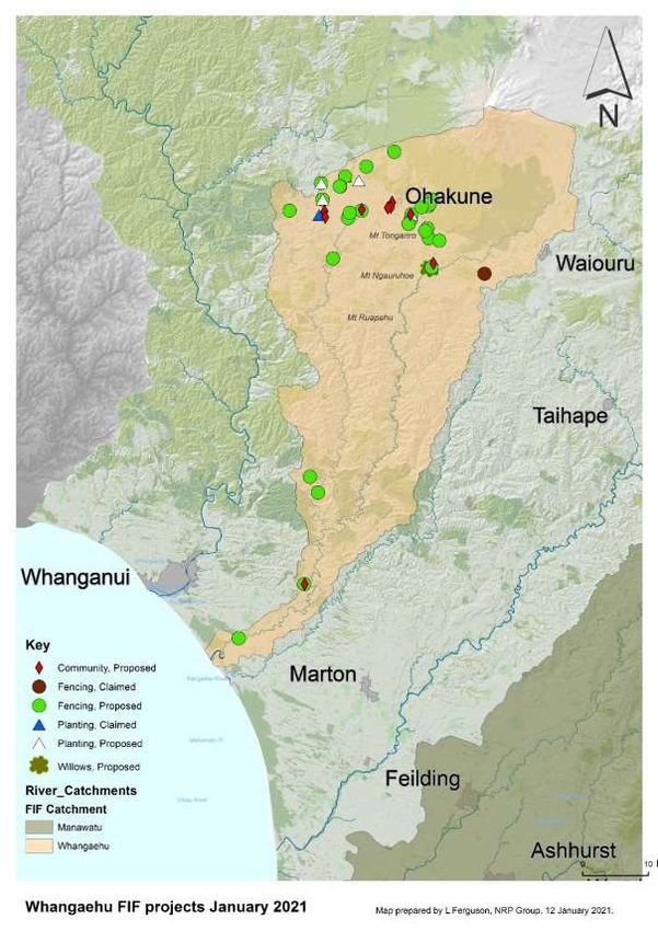
2.4 Whangaehu FMU
WHANGAEHU FRESHWATER IMPROVEMENT FUND (FIF) PROJECT
2.4.1 This programme focuses on the delivery of the Ngā Wai Ora o Te Whangaehu FIF
project, which focuses on the protection and enhancement of waterways within the
Whangaehu Catchment. The main components of the programme are supporting stock
exclusion from waterways, riparian enhancement and planting where desirable,
aquatic habitat enhancement, supporting industry and community-led initiatives, and
a joint project with Ngati Rangi.
2.4.2 With the Whangaehu FIF project set to end in June, stream fencing and riparian
planting allocations are now fully allocated. Any new landowners and enquiries in this
catchment are being signed up under the Jobs for Nature (previously the Regional
Freshwater Programme) to enable works to be completed.Figure 10: Stream fencing, riparian planting, and community projects that are proposed to be undertaken or have been completed in the Whangaehu Catchment.
2.5        Rangitīkei-Turakina FMU
           PFAS MONITORING FOR OHAKEA
    2.5.1 Horizons has been working with the New Zealand Defence Force (NZDF) on the
           ongoing monitoring of per- and ploy-fluoroalkyl substances (PFAS) and related
           compounds around Air Force Base Ohakea. PFAS are a large group of manufactured
           compounds that have industrial and consumer applications and have been in
           firefighting foam used at the base. A monitoring programme was specially designed by
           Pattle Delamore Partners Ltd this year to monitor the movement of the PFAS plume
           over time4.

    2.5.2 The first round of sampling was undertaken in September 2020 with preliminary
           results showing PFAS concentrations either similar to, or slightly below, the ranges
           previously recorded for existing monitoring locations. These results are in general
           agreement with the predictions from the groundwater modelling. Staff met with the
           Ohakea Water Contamination Committee at Manawatū District Council in
           December 2021 to discuss the preliminary results. The monitoring report is being
           finalised, and another round of sampling was to begin in late February 2021. A copy of
           the report will be made available on Horizons’ website.

           FLUVIAL PROGRAMME
    2.5.3 During 2020-21, fluvial surveying is focussing on the Kawhatau River, a key gravel
           source for the Rangitīkei River. This survey will extend beyond (i.e. up-stream of)
           previous surveys in the Kawhatau that focussed on the gravel beaches only, to further
           our understanding of the fluvial processes occurring throughout the wider catchment.

           STREAM FENCING AND RIPARIAN PLANTING
    2.5.4 This financial year 19.531 km of stream fencing and 28,810 riparian plants have been
           allocated within the Rangitīkei– Turakina FMU. To date, 6.294 km of stream fencing
           has been completed and 23,479 riparian plants planted.

           LAKE WAIPU/RĀTANA FRESHWATER IMPROVEMENT FUND (FIF)
           PROJECT
    2.5.5 As part of the FIF project Horizons commissioned NIWA to complete a native and pest
           fish survey of Lake Waipu on 7 and 8 December 2020. This work is to understand the
           availability of host species for kakahi (freshwater mussel) recruitment within the lake
           and the ongoing sustainability of the kakahi population. The native species shortfin

4
    PDP (2020) RNZAF Base Ohakea PFAS Investigation: Long Term Monitoring Plan
and longfin eels, and common bully were found in the lake, with the only introduced
species encountered being goldfish. A final report is due prior to the end of June 2021.
Figure 11: Left: Fish that were caught during the native and pest fish survey being
processed. Right: Conditions were grim as processing of the fish samples continued.
2.5.6 Horizons staff have been working with Rangitikei District Council (RDC) and MfE to
update the project plan for the wastewater management component of this project,
which is seeking to cease the discharge to water (to Lake Waipu) and to fully apply
the wastewater to land. A meeting was held with RDC, MfE, Horizons and landowners
during December 2020 to progress this project further. The work programme and
annual work plan are to be updated to reflect the proposed changes while the end
date of the project (June 2023) remains the same.
2.6 FMU
MANAWATU FRESHWATER IMPROVEMENT FUND (FIF) PROJECT
2.6.1 The first quarter of year three has been a busy one with the riparian planting season
coming to an end, the third round of community-led projects have been received and
enquiries for stream fencing and riparian planting continue to arrive, with an increase
noted around the time of the new stock exclusion regulations being introduced. With
current allocation for stream fencing and riparian planting, new applications are no
longer being sought for this financial year and are being allocated to next financial
year.Figure 12: Stream fencing, riparian planting and community projects proposed to be undertake n or completed in the Manawatū C atchment.
2.6.2 The Manawatū Accord Community Grants received 15 applications seeking $212,665
in funding. The decision-making panel agreed to fund eight new projects and one
additional project (Plastic Pollution) is in year two of its programmed milestones. This
gives a total of $88,136.00 of projects being funded this financial year. These are;
Construction of a Bioreactor – Te Maunga Farms Ltd;
Manawatu River Road enhancement and access – Te Kauru hapū collective and B
& P Drysdale;
Save our native fish (riparian fencing and planting) – Buckley Golf Club, Shannon;
Seeing, understanding & believing – a farmer-led project into waterway
improvement (workshops to share knowledge of wider catchment project) –
KapAg on behalf of Linton Streams Catchment Group;
Source of Kiwitea (continuation of planting a large gully system) – M & L Wills;
Waoku Stream Restoration Project (riparian fencing & planting) – D Okano;
Nguturoa Stream Restoration (riparian fencing, weed & pest control, preserve &
connect bush remnants) – C Finnigan on behalf of Linton Stream Catchment
Group; and
Whakaora Tapuata (weed control, riparian planting, cultural & awa monitoring) –
Te Kauru hapū collective.
2.6.3 The second quarterly report for the year, covering the period October through
December, was completed and submitted to MfE.
2.6.4 A Manawatū Accord Leaders Forum meeting was held on 2 December 2020, where the
Chair (Richard Thompson) announced he would be retiring from the position in coming
months. A replacement chair will be found in due course. At the Accord meeting it was
confirmed that Horowhenua District Council would host the Manawatū River
Improvement Festival on 27 February 2021 at the Manawatū River Loop Reserve
(Foxton).
2.7 Waiopehu FMU
2.7.1 The Waiopehu FMU (formerly Horowhenua) encompasses the Lake Horowhenua and
Lake Waiwiri, and the Ōhau and Waikawa River Catchments. Lake Horowhenua is a
taonga for local iwi/hapū and has a degraded state below many national bottom lines
for water quality. Toxic cyanobacteria causes the lake to be regularly closed for
recreation. This is related to large amounts of sediment and nutrients entering the
lake and the legacy contaminants already present.
2.7.2 The Ōhau and Waikawa estuaries also show signs of nutrient enrichment, with
estuary trophic index (ETI) scores within the moderate and poor categories. These
catchments are at risk of further eutrophication as a result of land use. Further
investigation is needed to establish the state of health in Hokio, Waiwiri and
Wairarawa estuaries.2.7.3 The Ōhau River itself is generally in good health, with a number of water quality and
ecosystem health attributes achieving National Objectives Framework (NOF) Band
A or Band B. The Waikawa Stream and its tributary the Manakau Stream, show mixed
results.
WORK TO DATE
2.7.4 Work to improve the state of freshwater in Waiopehu has been underway since 2013,
with Horizons working in partnership with the Lake Horowhenua Trust, Lake
Horowhenua Domain Board, Horowhenua District Council, Horizons Regional Council,
and the Department of Conservation as co-signatories to the Lake Horowhenua
Accord. Past and ongoing initiatives include:
The installation of a fish pass over the Lake Horowhenua Weir to enable fish
migration between the sea and the lake (Freshwater Clean-up Fund).
Construction of a sediment trap at the bottom of the Arawhata Stream, predicted
to reduce sediment phosphorus loads into the lake via streams by more than 25%
(Freshwater Clean-up Fund).
Lake weed harvesting to reduce cyanobacteria blooms and the toxicity effects of
the lake weed on fish in the spring (Freshwater Clean-up Fund).
Sediment and erosion control plans for vegetable growers covering 80 per cent of
the horticultural land in the Arawhata Sub-catchment of the Lake Horowhenua
Catchment (Freshwater Clean-up Fund).
Riparian fencing of 16 km has been erected and 24,000 plants put in along stream
banks by local communities and landowners with support from Horizons and the
Freshwater Clean-Up Fund.
The Future Proofing Vegetable Production project led by LandWISE, which
focusses on working with growers in the Horowhenua to develop use of precise
nutrient prescription, precise nutrient application, maximise retention of nutrients
and recapture nitrates that move beyond the root zone (Sustainable Farming
Fund).
FUTURE FOCUS
2.7.5 The focus for the next few years in the Waiopehu FMU will be to launch the weed
harvester on Lake Horowhenua, complete the Jobs for Nature Lake Horowhenua
wetlands project and upgrade our water quality monitoring programme to inform
water quality interventions through Jobs for Nature and complete freshwater
accounting for the FMU to inform the implementation of the new National Policy
Statement for Freshwater Management (NPS-FM).
WEED HARVESTER
2.7.6 Lake weed harvesting was recommended as a key restoration option for Lake
Horowhenua, incorporated into the Lake Horowhenua Accord and the Lake Accord
Action Plan. Lake weed alters the chemistry of the lake by increasing the pH of thewater, lowering the nitrogen concentration and providing a favourable environment for
phosphorus release and promoting cyanobacteria blooms. Harvesting weed interrupts
this cycle and provides an environment more favourable to fish and other aquatic life,
including native lake weeds.
2.7.7 Construction of the Arawhata boat ramp (Figure 13) that will enable launch of the
weed harvester onto Lake Horowhenua began in November 2020 and is due for
completion by May 2021.
Figure 13. Progress at the Arawhata boat ramp. Photo taken 17 February 2021 .
JOBS FOR NATURE
2.7.8 In 2020, a four-year $12.5 million project was announced for a Lake Horowhenua
wetlands programme to remediate nutrients and sediment in the Lake Horowhenua
Catchment. This project is funded through the Covid-19 recovery programme “Jobs for
Nature” ($11.2 million) by the Ministry for Environment (MfE) and partly funded by
Horizons ($1.3 million). The purpose of the project is to establish a wetlands complex
within the Arawhata Sub-catchment and an associated works programme of other
interventions around the lake to improve water quality and aquatic health in the
catchment.
2.7.9 Key elements of the proposed work programme are:
Establish a Governance Group (by June 2021).
Produce reports and modelling of the groundwater and nutrient/sediment
pathways and sources within the FMU to refine the placement of interventions for
water quality improvement (by June 2024). Implement at least one intervention that will result in water quality improvement
in the FMU, including designing and building a wetland complex (by 2024).
Communicate information on the lake and FMU to iwi/hapū and the community.
Employ one Freshwater Coordinator – Lake Horowhenua and three
monitoring/science staff.
2.7.10 The four-year funding term for this project commenced on July 1 2020, however
negotiations to finalise the contract with MfE are still in progress. With the end of the
first year of the project nearing, staff have been preparing the programme of work for
Year 1, however implementation deepends on the project being contracted. To date
the following preparation has been underway:
A workshop with technical experts held in August 2020 to refine information and
data gaps.
Development of an upgraded monitoring programme to support wetland design
and wider catchment interventions is being finalised.
Jacobs were contracted to conduct a wetland feasibility study in the Arawhata
Sub-catchment, including conceptual designs. This work is in the draft report
stage.
The draft Sedimentation and Drainage Management Plan for the Arawhata sub-
catchment has been completed by Tonkin + Taylor and a workshop will be held in
late February to discuss the findings and recommendations.
Planned activity in the coming months includes:
Employment of the Freshwater Coordinator – Lake Horowhenua and three
monitoring staff.
Commence the development of a nutrient and sediment budget and process for
freshwater accounting.
Develop a groundwater conceptual model to inform the nutrient budget
Further work to design and implement the constructed wetland project.
2.7.11 Some of our existing programmes dovetail into the Jobs for Nature work, including the
Integrated Sedimentation and Drainage Management Plan for the Arawhata Sub-
catchment which was scoped in 2019 and is near completion. The upgraded
monitoring programme will also inform the NPS-FM freshwater accounting process
which has been included as a key outcome in the design of the programme.
MONITORING AND SCIENCE
2.7.12 Lake Horowhenua and its tributaries have been monitored monthly for nutrients,
sediment and E. coli and flow since 2013. Water quality state and trends are available
on LAWA. Continuous flow and turbidity monitoring at the base of the Arawhata Sub-
catchment has been in place since 2018 and continuous flow monitoring was installed
on the Pātiki and Mangaroa streams in 2019. There are currently 17 groundwater levelmonitoring sites in the Horowhenua Catchment and monthly lake level measurements
were recently established for Lake Waiwiri.
2.7.13 Between 2016 and 2019, an intensive fortnightly monitoring programme was
implemented in the Ōhau and Waikawa Catchments to inform nutrient sources and
surface water groundwater interactions. This data will be used to inform estuary limit
setting, a project currently in the scoping stage.
2.7.14 The monitoring programme to support the Jobs for Nature project is currently being
refined, with the following proposed on top of the established State of Environment
programme:
A synoptic survey of the Arawhata, Mangaroa and Pātiki streams. Radon, tritium,
nitrate and isotopes will be sampled to establish the groundwater/surface water
interactions and determine nutrient sources. This is a
one-off investigation taking place in late February/early March 2021.
An extended groundwater monitoring programme for groundwater level and water
quality. Additional groundwater bores will be established, particularly in the
Arawhata Sub-catchment, to determine groundwater flow and nutrient pathways.
Additional continuous flow, nitrate and turbidity surface water sites will be
established further up the Arawhata Catchment than the current site at Hokio
Beach Road, to capture high rainfall events and identify nutrient and sediment
transport in more specific locations.
Nested piezometers will be installed around the perimeter of the lake to establish
the groundwater gradient and refine the lake water balance.
2.7.15 A conceptual model for the Horowhenua FMU is in the scoping stage and the intensive
monitoring will help inform a more detailed and refined groundwater model in later
years of the project.
2.7.16 During the quarter ending 31 December 2020, under the Future Proofing Vegetable
Production project, LandWISE have been setting up replicated nitrogen application
trials on 12 vegetable growers’ paddocks. The trials are to validate soil tests, nitrate
quick tests and the associated FAR Nitrate Mass Balance tool to make informed
fertiliser application decisions. Over the next month, field walks across the trial blocks
are planned with the wider growing community to reach as many growers as possible.
Staci Boyte
SCIENTIST - LAND
Mark Mitchell
SCIENTIST – WATER QUALITY (LAKES AND COAST)
Amber Garnett
ENVIRONMENTAL SCIENTIST – NATURAL RESOURCESStephen Collins SCIENTIST – GROUNDWATER Mike Patterson SENIOR SCIENTIST – FRESHWATER Raelene Mercer SENIOR SCIENTIST – WATER ALLOCATION Logan Brown FRESHWATER & PARTNERSHIPS MANAGER Abby Matthews SCIENCE AND INNOVATION MANAGER Jon Roygard GROUP MANAGER – NATURAL RESOURCES AND PARTNERSHIPS
You can also read