WATERFRONT AREA PLAN ltst uw'hw-nuts' ul-wum | we are working as one - Created for: Town of Ladysmith
←
→
Page content transcription
If your browser does not render page correctly, please read the page content below

WATERFRONT AREA PLAN      ltst uw’hw-nuts’ ul-wum | we are working as one

                                                         Created for:
                       Town of Ladysmith and Stz’uminus First Nation

                                                             Created by:
                                                               DIALOG

                                        January 2018 | FINAL DRAFT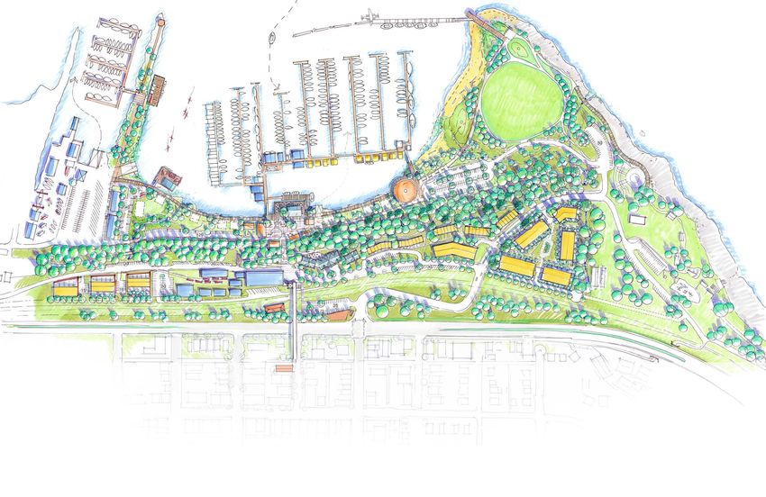
Community Charrette, March 2017
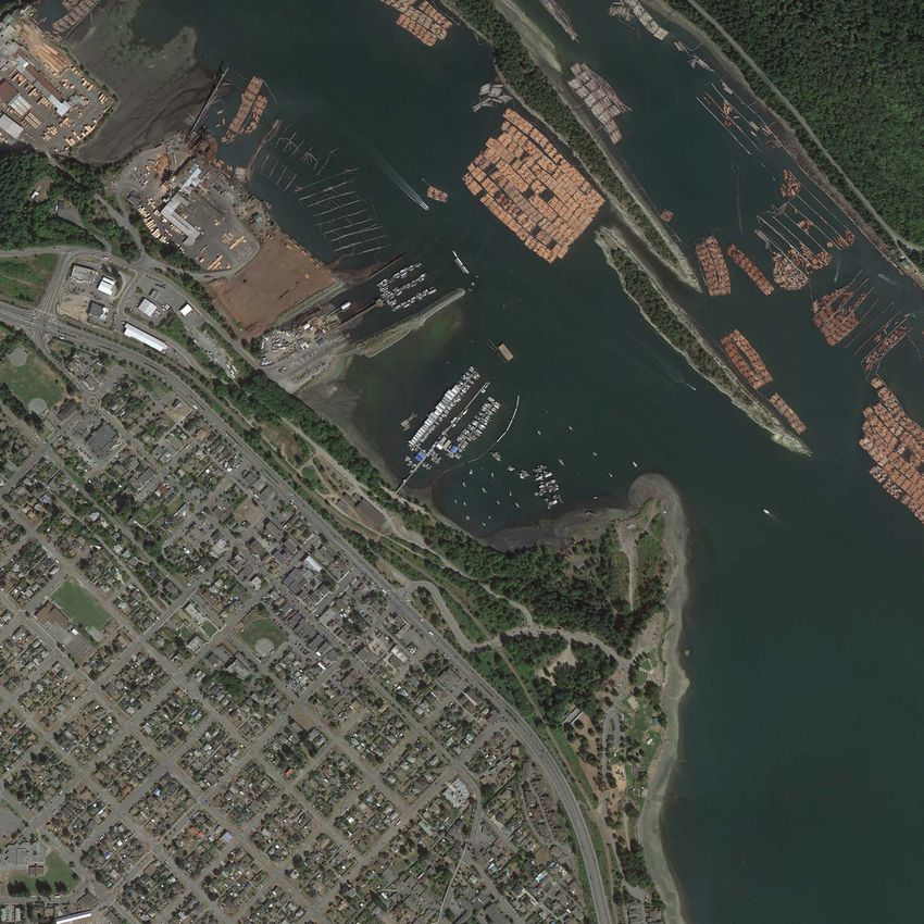
Table of Contents

PART 1: INTRODUCTION                             1
1.1 The Time Has Come					                       1
1.2 Time Immemorial						                        4
1.3. Industrial Heritage						                   7
1.4 Plan Area								 9
1.5 Timeline of Recent Planning Initiatives			  10
1.6 Planning Process                       				 13

PART 2: VISION, GOALS, and CONCEPT             17
2.1 Vision                                     19
2.2 Goals							                               20
2.3 Concept Plan                               21

PART 3: OBJECTIVES and POLICIES                27
3.1 Land Use                                   27
3.2 Parks and Open Space                       35
3.4 Mobility and Streetscapes                  38
3.5 Ecological Management                      42

PART 4: IMPLEMENTATION                         43

LIST OF MAPS

1   Plan Area							                         9
2   Concept Plan						                      21
3   Land Use Designations					              45
4   Transportation						                    46

LIST OF FIGURES

1   Stz’uminus Traditional Territory					    4
2   Snapshot of Public Participation					   13
3   The Future Waterfront					              17
4   Concept Plan Section Key 					          22
5   Local Road Design Concept					          40
“This project is about bringing   “On behalf of Stz’uminus, I
our communities closer in terms   want to thank the community
of how we work together. The      for coming out. We are here
challenges are very real and      for a reason, we want change
we understand that we need        also. Historically our people
to move forward toward the        lived here, harvested here
future.                           and thrived on resources in
                                  the harbour. We want to
This is a generational            restore what we can and move
opportunity for the people of     forward in a partnership and
Ladysmith and Stz’uminus. We      relationship where we can
are focused on solutions - we     build a future together. And
have to be positive and look      that is what we are doing.
forward, not look back.”
                                  This isn’t about whose side
               -Mayor Stone,      of the harbour it is, or whose
            Town of Ladysmith     harbour it is, this is about
                                  moving forward and making
                                  change for our children.
                                  Whatever this community and
                                  our community decides that
                                  is best, we all decide together
                                  and that’s how we are going to
                                  move this forward.”

                                                  -Chief Elliott,
                                         Stz’uminus First Nation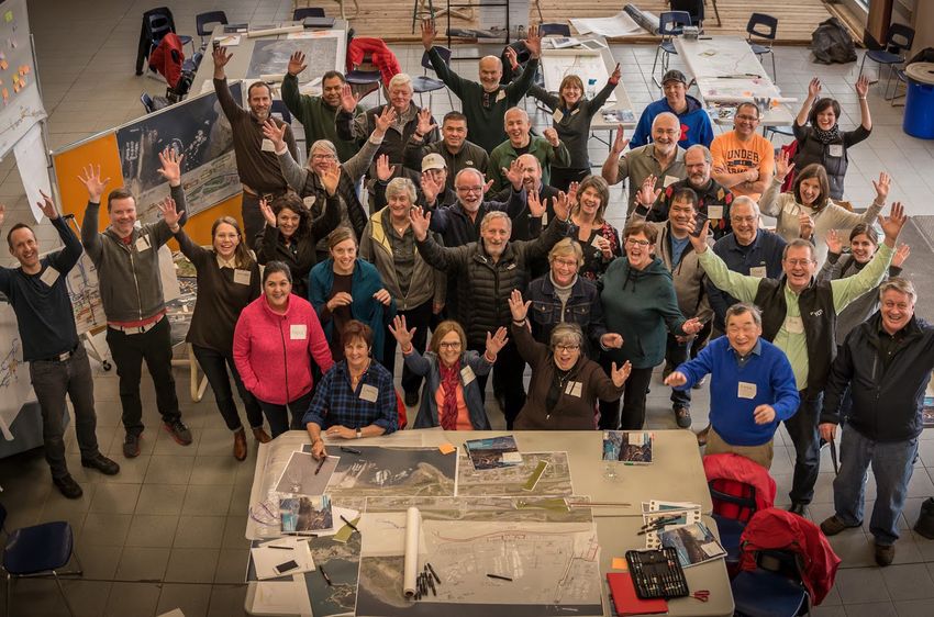
1. Introduction

1.1 THE TIME HAS COME

This is an important plan. It sets forth a vision   First, this planning process was rooted in a
for the Waterfront Area, guiding change that        partnership between the Stz’uminus First
will benefit generations to come. It is also        Nation and the Town. In 2007 and again in
the culmination of a planning process that          2012, the Town and Nation signed the First
brought together the Town of Ladysmith and          Community Accord, to work together to build
the Stz’uminus First Nation, strengthening a        a better relationship and develop partnerships
relationship and creating an outcome that seeks     for the mutual benefit of both communities.
to benefit both communities.                        This Naut’sa Mawt Community Accord has
                                                    been further strengthened by the signing of a
The Waterfront Area played and plays an             Memorandum of Understanding identifying
integral role in the life of both communities.      16 potential joint initiatives, including harbour
From time immemorial, these lands and waters        clean-up and expansion of marina services.
have nourished and been stewarded by the
ancestors of the Stz’uminus First Nation.           Second, this planning process benefited
Colonization and past industrial development        from environmental studies in 2010-2012
ruptured this relationship, and left ecological     that provided new and vital understanding
scars on the water, the foreshore, and              of existing conditions and cost constraints
the uplands. At the same time, industrial           relating to environmental contamination and
development gave rise to the unique character       geotechnical issues. This plan builds on many
of the Town of Ladysmith, which is valued for       other past plans, proposals, and studies as well.
its historic streetscapes that are rich with
public life.                                        Together, this improved understanding,
                                                    strengthened partnership, and emergent
Today, the waterfront is cherished by residents     community vision have driven the creation of
of the Town and Nation alike. There has been        this plan. This is a generational opportunity
much attention paid to planning for and the         whose vision could take 20-30 years to fully
development of the waterfront for many              build out. Beyond that, the waterfront will
years, including most recently in a 2008-           continue to grow and evolve along with the
2009 visioning exercise that helped clarify         communities that cherish it.
Ladysmith’s aspirations for the area. This
current Plan is set apart from past planning
processes in two important ways.

                                                     ltst uw’hw-nuts’ ul-wum | we are working as one    1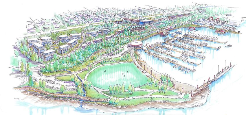
2 ltst uw’hw-nuts’ ul-wum | we are working as one
This Waterfront Area Plan has four main parts:     Policies
introduction, vision and goals, objectives and
policies, and implementation.                      The Objectives and Policies section sets
                                                   forth the specific land use designations of
Introduction                                       the Waterfront Area Plan and articulates
                                                   the objectives and policies for land and water
The Introduction provides an overview of the       use, public realm, mobility, and ecological
waterfront area, the historical context of the     management.
area, the planning process, new engineering
and geotechnical information, and the unique       Implementation
partnership that sets this plan apart from those
that came before.                                  The Implementation section provides guidance
                                                   for next steps in bringing the Plan to life. It
Vision & Goals                                     identifies short, medium, and long-term actions
                                                   that are intended to drive implementation
The Vision statement sets forth the aspirations    forward.
for the Waterfront Area Plan. It emerged from
a community design workshop that included
members of the Stz’uminus First Nation and
the Town of Ladysmith, and was informed by
the input of hundreds of residents. The goal
statements support this vision, while providing
more detail on specific components of the plan
elements.

                                                        ltst uw’hw-nuts’ ul-wum | we are working as one   3
1.2 TIME IMMEMORIAL

The Stz’uminus First Nation people are                   Recognizing the legacy of past misdoings, the
descendants of the first inhabitants of what             Stz’uminus First Nation and Town of Ladysmith
became known as Oyster Harbour and is now                are committed to working together to restore the
called Ladysmith Harbour. For thousands of years,        cultural values, improve the ecological health and
the Stz’uminus people have harvested from the            create economic opportunity on the waterfront
harbour, its creeks and rivers and surrounding           and in the harbour.
watersheds and forests, the Salish Sea, the Fraser
River valley and beyond. As Hul’qumi’num people,
they are stewards of the rich source of fish and
shellfish in their traditional territory.

However, with the completion of the E&N Railway
in 1886, and the construction of great shipping
wharfs in Oyster Harbour beginning in 1898 by
coal baron James Dunsmuir, the harbour was
transformed and became a centre for industry
and a shipping port for coal and other industries.
Millions of tons of coal wash (slack) and hundreds
of thousands of tons of wood debris were left                                                  Stz’uminus
behind by over 86 years of coal and forestry                                               Traditional Territory
                                                                              Vancouver
industrial activity.                                                            Island

The Stz’uminus, despite their continuing and
irrevocable presence since time immemorial,
became increasingly alienated from the
management of their lands for harvesting, cultural,                                           Olympic
                                                                                              Peninsula
spiritual and economic use. This was a result of
settler-colonial processes, which divided and sold
the land without the input of its original owners
and imposed an oppressive reservation and forced
residential school system.

                                                                               Figure 1: Stz’uminus Traditional Territory

4      ltst uw’hw-nuts’ ul-wum | we are working as one
“Ladysmith harbour is a very important, cherished, loved place of the Stz’uminus.
An unceded part of our territory... This was our paradise... Year round the uplands
and the ocean provided for us. What more could we ask for?
...Industry and pollution have affected our way of life. All around in the harbour
you’ll see middens, clam shells. Today, for the last 30 years, there has not been a
clam in this harbour fit for human consumption. Maybe longer than that. So there’s
work to be done.”
-Elder Ray Harris (Shulqwilum), Stz’uminus First Nation
ltst uw’hw-nuts’ ul-wum | we are working as one 56 ltst uw’hw-nuts’ ul-wum | we are working as one
1.3 INDUSTRIAL HERITAGE

The Town of Ladysmith had industrial ties from
the very beginning. James Dunsmuir created
a settlement on Oyster Harbour, shortly after
commissioning great wharfs, as a place for the
nearly 900 Extension Mine employees to live.

In 1904, the Town of Ladysmith was incorporated,
but the waterfront lands were not initially included
as Dunsmuir had no desire to pay municipal taxes.
By the end of 1911, the Town’s population was
nearly 3,300 people.

Coal continued to be a central economic force for
the Town - however, employee strikes, competing
coal mines, decreased demand for coal and finally
                                                                                     1901 Map Produced for Land Sales
the Great Depression resulted in the closure of
Extension mine in 1931. After the closure of the
mine, the town population shrunk by nearly 50%.
However, by 1935 Comox Logging and Railway
Company purchased a tract of forest to the west of
Ladysmith.

By the late 1940s, Ladysmith was the centre
of major logging operations and logging has
continued to play an important part of the town’s
economic development. Evidence of the Town’s
industrial history is clearly visible in the waterfront
area, including a rich collection of buildings and
artifacts. Unfortunately, there is also a legacy of
environmental contamination that is also clearly
visible on the waterfront. This plan addresses both.                                         Sacking Coal in Ladysmith

                                                          ltst uw’hw-nuts’ ul-wum | we are working as one           7
8 ltst uw’hw-nuts’ ul-wum | we are working as one
1.4 PLAN AREA

The plan area is located on the Salish Sea, an inland     The Plan area includes approximately 49 hectares
marine sea comprised of Juan de Fuca Straight,            in total area - 47% (23 hectares) of which are land
the Straight of Georgia, Puget Sound and their            and fill parcels, and 53% (26 hectares) of which are
connecting channels, passes, and straights.               water parcels. Significant natural features include
                                                          steep topography, with over 30 metres elevation
It is located between the Town of Ladysmith’s             change from the highway to the shoreline.
highly treasured Transfer Beach Park in the south,
well-established industrial areas in the north, and
the Trans Canada Highway to the west.

                                              Fisherman’s/
                                            Government Wharf

                                                          LMS Community
                                                              Marina

                                                                               D.L.651
                                           Machine Shop /
                                        Waterfront Art Gallery

                                                                                       Slack Point

                                                                                                             Map 1: Plan Area

                                                                 ltst uw’hw-nuts’ ul-wum | we are working as one           9
10
2007 - 2011 1986
LMS Community Marina Master Plan; Expo Legacy
Expansion Grant; Waterfront Development
Coordinator
2008 - 2009
including the following:
1990
Community Visioning Initiative
Including Waterfront Waterfront Development
Proposal – community rejects
2008 - 2013
1993 -1998
ltst uw’hw-nuts’ ul-wum | we are working as one
Couverdon Boundary Extension
Proposal (did not proceed) Sea Vision Development
Proposal (collects $2.5M in VC)
2009
- Clean-up of DL651 by the 1994 - 1997
Province
1.5 TIMELINE OF RECENT PLANNING INITIATIVES
- DL2016 Holding Corporation Waterfront Area Plan
Created
- Madrone Waterfront Area
Archaeological Impact Assessment
1999
2010 - 2012 - Town secures a 30- year lease
for Blk C, DL2016
Golder Associates - Transfer Beach Blvd
Environmental + Geotechnical constructed
studies - Redev’t of Transfer Beach Park
2011 2000 - 2003
Stz’uminus First Nation - Coast
This planning process stands on the shoulders of many past studies, planning processes, and initiatives,
Granby Harbour Dev’t Proposal
Salish Dev’t Corp Vision2012 2003
- Naut’sa mawt Community Official Community Plan
Accord Signed by Town and
Stz’uminus
Ladysmith Maritime Society
Community Marina Upgrades
(DL2016)
- Naut’sa mawt Steering 2004 - 2006
Committee Formed
Waterfront Development
Planning and RFP
2013 - 2016
Sustainability Action Plan 2006
- RFP issued for comprehensive
mixed use concept
- First Principles proposal – did
not proceed
2014 - Key issues: relationship
between SFN and Town;
The Machine Shop (Lot 4)
added to Community Heritage
Quantifying clean-up costs; Role
Register of Lot 5; Use of park land
-Joint Council meetings start
2016
2007
Stz’uminus history included in
First Community Accord signed
Transfer Beach Park
by Town and Stz’uminus
2016 2007 - 2009
Waterfront Area Plan - Planning
Fisherman’s Wharf Breakwater
and Design Project Commences
Proposal
ltst uw’hw-nuts’ ul-wum | we are working as one
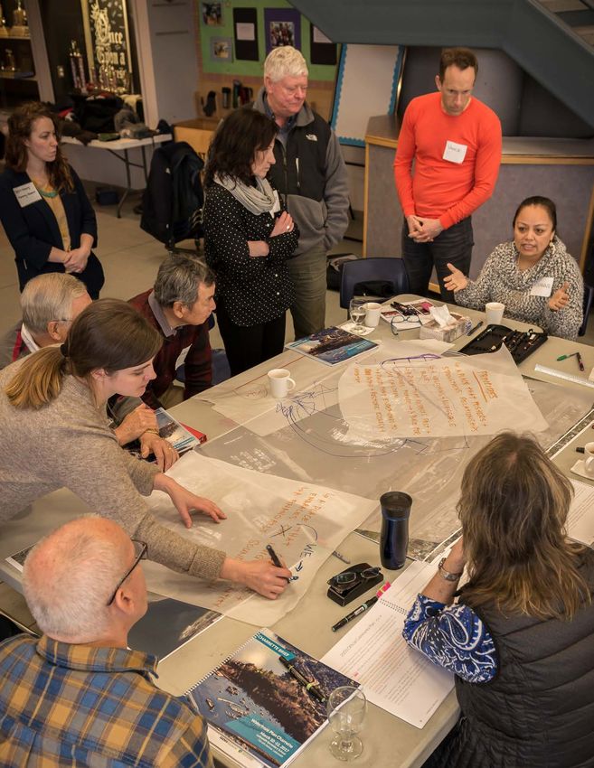
111.6 THE PLANNING PROCESS • Two workshops with property owners and
tenants, one of which included the Town’s
The policies in this plan are built on a vision created advisory committees and commissions;
by the community. It is a vision that sees the • A Speakers Night including Elder Ray
waterfront as a place where both Ladysmith and Harris and visiting experts on waterfront
Stz’uminus communities come together as one. development and indigenous design;
As of August 2017, an estimated 1500+ distinct
participant interactions took place and included • Stakeholder meetings with the Coast Salish
the following activities: Development Corporation, Ladysmith
Fisherman’s Wharf Association, Sealegs
• Ongoing discussion with Mayor Stone and Kayaking, and a number of service clubs;
Chief Elliott, and members of both Councils;
• Two online surveys, with input from people
• Mapping and discussion with diverse groups representing all age categories and including
in Ladysmith, including with the Secondary residents, business owners, employees, and
School Leadership Class, Seniors Centre, students, as well as a handful of visitors;
Ladysmith Family and Friends, and passersby in
• A 2-day design charrette, involving
community facilities and businesses;
approximately 25 participants from both
• Discussions with Town and Stz’uminus Ladysmith and Stz’uminus communities; and
administration staff;
• Two public open houses that enabled residents
to review the ideas that emerged from the
charrette, and the draft concept plan.
DIAGRAM TO BE UPDATED AFTER JANUARY ENGAGEMENT Figure 2: Snapshot of Public Participation
ltst uw’hw-nuts’ ul-wum | we are working as one 1314 ltst uw’hw-nuts’ ul-wum | we are working as one
Themes from the Community Visioning
During the visioning process and leading up to the community charrette, a number of themes emerged
across diverse engagement activities and stakeholder groups. They are as follows:

     Maintain and enhance public access to the           Strengthen the relationship between the
     water, including with boardwalks and other          Stz’uminus and Ladysmith communities.
     walking connections.                                Establish a cultural hub that includes
                                                         Stz’uminus values, ideas, and history.

     Create destinations for residents (primarily)       Protect and restore ecological value –
     and tourists (secondarily) to gather, eat,          including by addressing environmental
     shop, play, and linger.                             issues relating to derelict vessels and
                                                         contamination of Slack Point.

    Protect the integrity of the working waterfront
    and celebrate its authenticity.

                                                        ltst uw’hw-nuts’ ul-wum | we are working as one   15
“I believe we are on the right track “All development should in regards to being respectful to celebrate the Stz’uminus First each other as long as we plan Nation culture, both current and for the greater community and historic... The waterfront project be inclusive of both sides of the is a unique opportunity to show harbour... We as the First Nation our Stz’uminus neighbours and side would like to see ourselves the world that we recognize be represented in the town. I our settlement on Stz’uminus know there is a history, some of it land, that we embrace their not good, but when we put that presence, and that we welcome behind us and move forward we their guidance now and into the can create a greater community future.” for our children and children’s children. I know in my heart we are moving forward.” -Ladysmith project participant -Stz’uminus project participant
2. Vision, Goals & Concept

The vision and the goals were informed by the extensive community input received over the life
of the planning process, and emerged directly from the community design workshop that included
members of both the Stz’uminus First Nation and the Town of Ladysmith. Both communities
worked to articulate a shared vision that captured their hopes and aspirations for the future of the
waterfront.

The vision is included on the following page, and is based on the communities’ idea that when
Town and Stz’uminus residents plan for the future of the waterfront, they should do so from the
perspective of “The Big We”. In other words, it’s not “we in Ladysmith” who will guide the future
of the waterfront, and it’s not “we at the Stz’uminus First Nation” who will guide the future of the
waterfront. Rather, it’s “we in Ladysmith and in the Stz’uminus First Nation”. Together we decide,
and together we benefit.

                                                      Figure 3: The future waterfront – view from south of Slack Point.

                                                      ltst uw’hw-nuts’ ul-wum | we are working as one                17
18 ltst uw’hw-nuts’ ul-wum | we are working as one
2.1 VISION FOR THE WATERFRONT
                                  ONE HEART
                                      +
                                  ONE MIND:

          ltst uw’hw-nuts’ ul-wum (we are working as one)
       to create a waterfront for now and future generations

  Located on the un-ceded traditional territory of the Stz’uminus First Nation,
   the waterfront area will bring our Stz’uminus and Ladysmith communities
together to build a shared legacy in the spirit of mutual respect and benefit. The
waterfront area will be a place of enriching public life, living, learning, creativity
  and economic activity. The respectful development of this special place will
 create the opportunity for community prosperity, ecological regeneration and
 brownfield restoration while honouring past, present and future generations.

                                               ltst uw’hw-nuts’ ul-wum | we are working as one   19
2.2 GOALS creating more destinations to showcase Stz’uminus
and Ladysmith history and culture.
Extending from the Vision, the following goals
provide the building blocks of this Plan.
9. Connections
1. Public Waterfront Access Improve connections in all directions, including to
the Downtown for residents and visitors alike.
Maintain and enhance continuous, public access
along the waterfront.
10. A Place for Walking
2. Stz’uminus Presence on the Water Make walking delightful and design places for
Re-establish presence of the Stz’uminus First people on foot and mobility-supporting devices for
Nation on and near the water. all ages and abilities.
3. Honouring the Earth and Water 11. Expressive Personality
Honour the ecology of the waterfront area, Reflect the uniqueness and authenticity of the
including its related traditional uses and culture. waterfront in the form and character of buildings
and public spaces.
4. Working Waterfront
Protect the authenticity and integrity of the 12. Viable and Mutually-Beneficial Development
working waterfront, including its employment- Support implementation with development
generating uses. approaches that leverage land value and optimize
mutual benefit for both Ladysmith and Stz’uminus
5. Sharing Spaces communities.
Establish places for both Ladysmith and Stz’uminus 2.3 CONCEPT PLAN
communities to come together to share, learn,
and celebrate one another, while also protecting The vision and goals are manifested in the
the privacy of sacred ceremonies and hereditary overarching Concept Plan presented on the
teachings. following page. While the Concept Plan is not
intended to be a blueprint for construction, it does
6. Year Round and Multi-Generational People provide a decision-making framework for land use,
Places built form, open space, and transportation.
Create destinations for multi-generational locals Land-Based Uses
(primarily) and tourists (secondarily) to live, gather, The proportion of different land-based uses (not
eat, shop, play, linger, and take in the view all year including marina and moorage areas) are shown below.
long. Refer to Map 3: Land Use Designations.
Park 51.9%
7. Regenerative Design
Commercial 16.5%
Protect and restore ecological values through
Residential - 9.2%
remediation of contaminated foreshore and Apartments
uplands, land use and the design of buildings, open
Residential - 2.9%
spaces, and infrastructure. Townhouses
Institutional 10.5%
8. Cultural Hub Mixed Use - 3.4%
Live-Work-Learn
Strengthen and build on existing cultural strengths,
Industrial 5.7%
20 ltst uw’hw-nuts’ ul-wum | we are working as oneMap 2:
Waterfront Concept Plan
2
6
1 4
5
8 3
12 N
11
9
7
10
1. MARINE SERVICES CENTRE could be accommodated in the reconfigured open area. The 9. ARTS AND HERITAGE HUB 12. RESIDENTIAL DEVELOPMENT
Existing facility with expanded and improved marine vessel 4. STZ’UMINUS FIRST NATION CULTURAL existing gravel parking would be retained and improved, with
Identity, character, and existing conditions are enhanced in A mix of housing types ranging from 2-3 storey townhomes
repair and maintenance yard, with additional boat lift CENTRE additional parking to support marina activities. Stz’uminus
this key central area to further define it as a creative, arts to 5-6 storey apartments create housing choice and revenue
cultural references are incorporated into the park.
equipment, amenity buildings, associated site parking, and As an integral feature of the future waterfront, the SFN and culture, and heritage hub, building on current activities for investment in public amenities such as the waterfront
marine fuel services. Cultural Centre is sited on the water’s edge. It’s future and structures. The Machine Shop is maintained. walkway. Many of the community’s priorities for the future
design will be led by SFN, and is expected to include spaces 7. LIVE-WORK-LEARN of the waterfront require capital investment, and the
2. COMMERCIAL FISHING WHARF to showcase Stz’uminus culture, artist spaces, and retail Mixed used live-work-learn buildings – with ground-level 10. GATACRE OVERPASS residential development will assist in covering costs.
Reconfigured boat docking with new access and vehicular spaces such as a cafe. commercial, institutional, light industrial or entrepreneurial (PEDESTRIAN BRIDGE)
turnaround on the breakwater, with potential expanded spaces for the tech industry or arts studios and residential A pedestrian overpass/bridge safely and efficiently connects The location of these homes is behind the existing forested
space for marine services. Note: Adjacent public boat launch, 5. WATERFRONT WALKWAY uses above – are adjacent to the creative activities within the downtown with the cultural hub and overall waterfront ridge and does not cast shadow on the public waterfront
washrooms, and boat trailer parking is maintained. A continuous waterfront walkway establishes public access the Machine Shop and surrounding structures. area. walkway or impede views from upland areas. Public
to the water, extending from the commercial fishing wharf to pedestrian linkages are included in the site plan.
3. MARINA LANDING Slack Point, and further south to Transfer Beach Park. 8. FILLED FORESHORE & ACCESS ROAD 11. WATERFRONT INN
Improved vehicular access is enabled by the filling of A retained and filled foreshore on either side of the A small boutique hotel or inn offers amenities to visitors by
foreshore to the north. The new additional space will 6. SLACK POINT PARK community marina, combined with restorative ecological land or water, and includes publicly-accessible destinations
provide water-oriented enterprises and programming, such Substantial environmental improvements are achieved habitat plantings along the length of the new foreshore for locals such as culinary and recreational opportunities.
as a paddling centre and expanded drop-off and turnaround through the capping of the park area and surrounding and submarine areas, creates room for improved vehicular This Inn will be differentiated from and complementary to
area. Additional parking, access and services to the south will foreshore and submarine floor. New plantings would access to the expanded marina. It also provides opportunity hotel development at Oyster Bay.
support the communities’ expanded marina, where limited improve ecological health, and a variety of park for additional marina parking and water-oriented amenities,
boat shelters and possible float homes may be established. programming and events, such as concerts and festivals, as well as the possibility of future small-scale retail
destinations, such as a pub.The following pages contain sections cut through the Waterfront Plan Area. Sections are meant to represent a conceptual vertical cut through the plan area showing topography, landscaping and natural areas, road
network and buildings. Sections help to demonstrate the relationship between different plan areas from the uplands to the water’s edge. The key map below shows the area that each section represents.
G
F H
A E
B D
C
Figure 4: Concept Plan Section Keyhighway rail live-work-learn buildings
upper road improved
existing trail
filled foreshore
parking and walkway paddling centre
A. LIVE-LEARN-WORK AREA (BULLER STREET)
filled foreshore
parking (with access from north) and walkway
B. FILLED FORESHORE AREA‘Marina Landing’
8 - 10 m water-oriented retail
access road
8 - 10 m
walkway
C. ‘ MARINA LANDING’ DROP-OFF AREA
Gatacre Overpass
highway ‘Arts and Heritage Hub’ (shown behind)
(pedestrian bridge)
relocated road boutique hotel/inn
‘Marina Landing’
drop off area pub
D. HOTEL AND PUB (GATACRE STREET)existing forest
edge maintained
trail
waterfront
boardwalk / walkway
E. WATERFRONT WALKWAY
improved ecological conditions
Transfer Beach
highway Boulevard rail moved road residences residences forest edge
trail walkway
Stz’uminus First Nation
Cultural Centre
F. RESIDENTIAL AND STZ’UMINUS FIRST NATION CULTURAL CENTRE (BADEN-POWELL STREET)‘Slack Point Park’ waterfront
capped with restorative habitat plantings boardwalk / walkway
G. SECTION THROUGH SLACK POINT BEACH / FORESHORE
setback
new
highway rail trail road setback residences Transfer
Boulevard Slack Point Park
setback
H. PRIMARY RESIDENTIAL AREA3. Objectives & Policies
3.1 LAND USE plus a small-scale full-service hotel or inn of 40-80
rooms, along with the services associated with the
The next section of the Waterfront Area Plan communities’ expanded marina. The live-work- learn
provides objectives and policies for the land uses development could accommodate another 4,000
provided for in the concept plan. The conceptual square metres (43,055 square feet) of mixed use
precincts are broken into land use categories as space.
illustrated on Map 3 – Land Use Designations.
The Arts and Heritage Hub at the Machine Shop is
Residential land use is considered an appropriate designated as institutional land use. The concept plan
form of development for certain locations on the supports maintaining and expanding on the current
waterfront. Residential development is primarily heritage and creative arts activities taking place
focused on the uplands and includes ground level today. The railway station is located in this area along
townhouses and apartment style units. New with and a new highway-oriented Visitor Centre.
development is intended to create a vibrant, Approximately 2,500 square metres (27,000 square
diverse welcoming people place through a mixed- feet) of existing community space is included in the
use neighbourhood as outlined in the following plan, along with the potential for an additional 1,400
section. New residents will also support businesses square metres (15,000 square feet) of new space.
elsewhere in Ladysmith, including the downtown. It
is expected that the Waterfront Area could include Marina and moorage land use areas encompass the
approximately 325-350 residential units of various Fisherman’s Wharf, Ladysmith Maritime Society
types for a potential population at build-out of about Community Marina and the adjacent water lot
750-800. This is a significant change from the 1997 planned for marina expansion. The scale of marina
plan which anticipated a much larger residential development should maintain the small scale harbour
population, with the removal of Slack Point as a character of Ladysmith. The marina areas are in close
development area. proximity to marina-oriented commercial use, such
as a restaurant or pub, as well as the Stz’uminus First
Commercial land use areas are shown near and along Nation Cultural Centre and expanded parking and
the shoreline in an area of extended fill and a small- drop-off areas.
scale hotel or inn is provided for in the centre of the
site. A mixed use live-work-learn precinct is located The waterfront area is adjacent to the Rocky Creek
on the upland in an area where neighbouring uses Industrial Park to the north. The existing marine
include industrial activity, the rail corridor and the services centre is supported as a key component
arts and heritage hub. The commercial land uses of the working waterfront and has been identified
are intended to support a year-round destination as industrial land use. Future uses to support the
for residents and visitors, as well as complimentary fishing industry and other marine activity could be
services to the downtown. The Waterfront Area Plan co-located in this area. This expanded area could
accommodates 1,500 square metres (16,145 square support up to 1,350 square metres (14,500 square
feet) of space for retail and food and beverage, feet) of marine-related industrial and retail space.
ltst uw’hw-nuts’ ul-wum | we are working as one 27The objectives and policies for the land uses within • To maintain the working waterfront, including
the Waterfront Area are presented in this section. by protecting the existing industrial, commercial
fishery, artisanal, and other employment-
OBJECTIVES generating uses.
• To provide for commercial development
• To represent both Stz’uminus and Ladysmith
that serves both locals and tourists, and that
cultures in land and water use.
activates and supports public life.
• To create diverse destinations that activate the • To provide for commercial development that
Waterfront Area all day, all week, and all year. provides a differentiated and complimentary
• To introduce residential uses that provide commercial experience relative to Downtown
housing choice for diverse household types. Ladysmith and the Oyster Bay development.
• To establish residential densities that support • To establish a cultural hub with diverse arts,
waterfront commercial uses, create value for heritage, and other cultural uses.
investment in public assets, and are respectful • To establish conditions that will support
of the scale of existing development in Town. brownfield clean up and access to external
• To create the conditions that enable traditional funding.
uses and activities.
28 ltst uw’hw-nuts’ ul-wum | we are working as onePOLICIES
Residential
1. Provide a mix of housing types, including
ground-oriented townhomes, apartments, and
mixed-uses with residential above.
2. Support the potential for float homes and a
variety of residential tenure options.
3. In areas designated as “Residential 1” in Map
3 – Land Use Designations, permit multi-unit
residential building form and character that
supports: Multi-family residential buildings should be designed to establish a low
storey street presence, for example, through upper-storey setbacks.
a. up to 6-storey apartment-style buildings,
with lower heights along the street, and
with upper-storey setbacks;
b. approximately 1.5-2.0 FSR; and
c. density of approximately 115 units per
hectare.
4. In areas designated as “Residential 2” in Map
3 – Land Use Designations, permit multi-unit
townhome building form and character that
supports:
a. up to 3-storey ground-oriented attached
buildings;
b. approximately 0.75-1.0 FSR; and
c. density of approximately 37 units per
hectare.
Mult-family townhomes should provide housing choice while
5. In the area designated “Marina and Moorage” maintaining a ground-oriented, small-scale character.
in Map 3 – Land Use Designations, enable
the presence of up to 2-storey float homes
along the north-south float in the expanded
communities’ marina as appropropriate, and as
shown in Map 2 – Concept Plan.
6. Require that site planning respect natural
features, protect views from important public
space, and optimize solar access.
7. Require underground parking for multi-family
residential development in areas designated
as “Residential 1” in Map 3 – Land Use
Designations.
8. Apply Development Permit Area 4 – Multi-
Unit Residential to all multi-family residential Careftul site planning should incorporate topographical elements that
development. protect the natural environment and avoid impacts on existing views.
ltst uw’hw-nuts’ ul-wum | we are working as one 29Mixed Use and Commercial
1. In the area designated as “Mixed Use” in Map
3 – Land Use Designations, allow 2-3 storey
buildings:
a. that are vertically mixed enabling live-
work and/or live-learn opportunities with
residential uses above; and/or
b. that are single use to accommodate
additional residential mix within the
planning area, or other emerging uses
such as a technology hub or learning
centre associated with Vancouver Island
University.
A diverse mix of uses – including marina, commercial, and industrial –
2. In areas designated as “Commercial” in Map should cater to both tourists and locals.
3 – Land Use Designations, allow 1-2 storey
commercial buildings, including small-scale
single storey uses that cater to both locals
and tourists, such as cuisine, artisanal and
arts-oriented retail, and marine-oriented
businesses.
3. Support the establishment of one or more
retail uses on the water, such as a floating pub
or restaurant, as part of marina development.
4. Support the establishment of commercial
uses that are unique to the waterfront area,
and complimentary to commercial uses in
downtown and the Oyster Bay development.
Commercial uses should be unique to the waterfront. Examples include
seasonal floating commercial uses such as restaurants.
5. Support the establishment of a small-scale,
boutique hotel or inn that is differentiated
from and complimentary to existing hotel
development in the Oyster Bay development,
and is comprised of approximately 40-80
rooms.
6. Consider permitting the hotel or inn to contain
elements that are up to 4 storeys subject to
completion of a view study.
7. Support flexibility in the hotel site to permit an
extension of the area identified as “Residential
2” in Map 3 – Land Use Designations, if the
hotel requires less area due to a smaller size.
The small-scale structures in “Marina Landing” can be used for retail,
incubation spaces for artists, or other related uses.
30 ltst uw’hw-nuts’ ul-wum | we are working as one8. Support the extension of the foreshore as
shown on Map 2 – Concept Plan up to the
lowest low-tide line as a way to cap and
restore the foreshore condition and provide
stabilization.
9. Support the establishment of a Stz’uminus First
Nation Cultural Centre as identified in Map
2 – Concept Plan. Potential uses may include
cultural spaces, artist spaces, retail uses such as
a cafe, and other possible uses.
10. Apply Development Permit Area 3 –
Commercial to mixed use and commercial
development, except for the design of the
Stz’uminus First Nation Cultural Centre which
shall be determined by the Stz’uminus First
“Add a boardwalk with retail and dining -
A Stz’uminus First Nation Cultural Centre will be a vital component of
tourists and locals would love a waterfront the Waterfront, and whose design approach is yet to be determined.
year round restaurant”. Photo credit: www.swinomishpolice.org
-Process participant
Spaces for for cultural celebration will be included throughout the
area.
ltst uw’hw-nuts’ ul-wum | we are working as one 31Institutional
1. In the area designated as “Institutional” in
Map 3 – Land Use Designations, support the
establishment of an Arts and Heritage Hub,
allowing culture-oriented uses that could
include but are not limited to artist studios,
museums, community and recreational uses,
cultural and interpretative centres, artifact
restoration and display, carving sheds, and art
galleries.
Cultural uses should embrace both Stz’uminus and Ladysmith cultures,
providing opportunities for cross-cultural sharing, learning, and
2. Work with the communities to create a master enterprise.
plan for the Arts and Heritage Hub.
3. Protect and utilize the Machine Shop and area
for ongoing use, and as a central anchor within
the arts and heritage hub.
4. Utilize materials and other design cues in new
buildings that complement the character-
defining elements of vernacular, utilitarian
Comox Logging and Railway Shop Buildings
– rather than seeking to merely duplicate the
historic character – through the use of: The Arts and Heritage Hub should build on the existing activities and
»» large sliding doors; character of the Machine Shop.
»» significant glazing for natural light and
ventilation; and
»» and corrugated tin cladding.
5. Utilize the Guidelines and Standards for the
Conservation of Historic Places in Canada to
guide restoration of the Machine Shop.
6. Continue to seek external funding for building
restoration as an important component of
maintaining community use of the Machine
Shop.
7. Work with community groups to establish a
Visitor Centre as identified in Map 2 – Concept
Plan.
8. For the Visitor Centre building, utilize a
contemporary architectural expression that
references the character of the area while
Example of a new building that uses corrugated tin cladding to
providing design expression that helps to complement historic industrial uses.
establish a gateway experience.
32 ltst uw’hw-nuts’ ul-wum | we are working as oneMarina and Moorage 10. Integrate existing built assets where possible
during development.
1. In areas designated as “Marina and Moorage”
in Map 3 – Land Use Designations, allow: 11. Respect public views of the waterfront from
a. marina development that caters to visitors, the uplands, Slack Point, Fisherman’s Wharf,
vacationers, and locals , enabling short and further out in the harbour in the design of
and long-term moorage, service facilities, development on the water.
public wharfs, museums and other cultural
facilities, cafe; 12. Apply “Development Permit Area 1 – Maritime”
b. a limited number of float homes; to marina development.
c. small-scale retail that could be year round
or seasonal;
d. commercial fishing wharf and related
services; and
e. boat launching facilities for all types of
boats whether with power or not.
2. Support the short-term moorage of boats as an
interim use prior to marina expansion through
the use of mooring buoys.
3. Encourage the design of breakwater facilities
to include pedestrian access.
4. Explore the feasibility of allowing docking of
seaplanes.
5. Work with Federal and Provincial agencies and
community resources on initiatives to remove
derelict and abandoned vessels.
6. Support the existing commercial fishery
and ancillary services at Fisherman’s Wharf,
situated on federal lands.
7. Support fish sale activities on Fisherman’s
Wharf in order to support local fishing activity
and to further establish the waterfront area as
a destination and unique experience.
8. Limit the replacement of existing boat houses
in the community marina to modest open sided
boat shelters, in order to protect public views.
9. Limit any new marina development to slips
without boathouses or boat shelters.
ltst uw’hw-nuts’ ul-wum | we are working as one 33Industrial
1. In areas identified as “Industrial” in Map 3
– Land Use Designations, support existing
marine industry and services as part of the
working waterfront.
2. As part of improvements to the Marine
Services Centre, work with Small Craft
Harbours to explore opportunities for the
establishment of a fishery processing facility
for use by the Stz’uminus First Nation and
others.
3. Support the establishment of other uses, such Complementary uses and activities such as seafood sales should
strengthen existing industrial uses, help contribute to the authentic
as a fuel dock and shared barge facility within character and functioning of the working waterfront, and establish a
the Marina Services Centre. unique experience and draw for both locals and visitors.
4. Apply Development Permit Area 5 – Industrial
to new industrial development.
The Stz’uminus First Nation continues to be active in the fishing
industry, including harvesting of shellfish. A processing facility would
help facilitate expansion of this industry.
“Industrial, environment, community
merging together [is] a priority”
-Process participant
“[I want to see] a Granville Island look with
arts and industry together”
-Process participant
34 ltst uw’hw-nuts’ ul-wum | we are working as one3.2 PARKS AND OPEN SPACE • To continue to build on the amenities and
programming at Transfer Beach Park.
The Ladysmith waterfront is an important location
for residents and visitors to enjoy both active and POLICIES
passive recreation opportunities. Parks and open
space land use areas are important elements of the 1. Establish a continuous pedestrian walkway that
concept plan, representing three times the area of functions as both a destination and open space,
Transfer Beach Park. as well as a connection, along the entirety of
the waterfront, from Fisherman’s Wharf to
Transfer Beach Park is currently the focus of most Transfer Beach Park.
of the formal recreation activity on the waterfront.
The creation of a new park in the area of Slack Point 2. Utilize distinct treatments for the waterfront
is a key component of creating a people place and as walkway that add visual interest, reference the
a brownfield renewal strategy. sense of place, and bring together the different
precincts, recognizing that this walkway is
The natural landscape of the waterfront area – the the unifying thread for the waterfront area,
various benches and steep slope topography, the including:
existing vegetation, the shoreline and the harbour –
a. meandering elements to add interest;
form the basis of a natural space framework for land
use and future development on the waterfront. b. a boardwalk-like treatment, made of wood
treated in a manner appropriate for wet
With existing Transfer Beach Park and the Parks environments and that minimizes slippage,
and Open Spaces illustrated in the concept plan, or detailed concrete planks to provide a
well over half of the Waterfront area is designated sense of boardwalk; and
for Parks and Open Space. c. a sturdy, well-lit hand-rail system that
supports safety, while ensuring the
OBJECTIVES retention of visual permeability to the
water.
• To represent both Stz’uminus and Ladysmith
cultures within parks and open space, and to 3. Allow for gathering places and help define the
promote cross-cultural sharing and learning. character area of Marine Landing by providing
special seating treatment, and by delineating
• To protect and enhance public access along the the area from the waterfront walkway through
waterfront. timber bollards.
• To provide a diversity of open spaces in terms of
scale, function, program, and character through
utilization of both land and water.
• To celebrate views and topographical features,
and reinforce the natural environment as one “[I would like to see a] continuous
of the defining features of the waterfront waterfront walkway from Government
character and experience. Wharf past Transfer Beach Amphitheatre.”
-Process participant
• To utilize the restoration of brownfield sites as a
means to create parks and open spaces.
ltst uw’hw-nuts’ ul-wum | we are working as one 354. Utilize Provincial and Federal brownfield associated with cultural facilities and
renewal and other resources to create a elsewhere.
new park at Slack Point as shown in Map
2 – Concept Plan, connecting to Transfer 8. Integrate the pedestrian overpass (refer to
Beach Park and providing for a variety of park Section 3.3) with pedestrian spaces adjacent
programming and events. to the Arts and Heritage Hub, and with walking
connections to the Marina Landing plaza and
5. Work with the communities to create a Master waterfront.
Plan for the redevelopment of Slack Point as a
park. 9. Optimize views and identify lookout points
from the public realm to the water, particularly
6. Maintain flexibility in open space design, from higher elevations and on topographical
in order to include the communities’ features that facilitate scenic views.
programming on land and in the water.
10. Design open spaces to protect views and sight
7. Create spaces for cross-cultural sharing lines as best as possible from the downtown to
and learning such as events, interpretative the harbour, and from the shoreline to Town
trails, medicine walks, historic interpretation, and across the water.
amenities, public art, and other programming
S p a c e s a n d f a c i l t i e s w i l l s u p p o r t d i v e r s e c u l t u r a l e v e n t s t h a t b r i n g c o m m u n i t i e s t o g e t h e r.
36 ltst uw’hw-nuts’ ul-wum | we are working as one11. Retain treed areas within the Parks and Open
Space designation as shown in Map 3 – Land
Use Designations, to allow for the protection
of environmentally sensitive areas, steep slopes
and retention of trail resources.
12. Give preference to high branching tree species
in order to assist in view protection from public
spaces.
13. Create spaces for resting, lingering, gathering,
and people-watching in both public and private
realms, and throughout the open space and
Adaptive heavy timber seating allowing for a variety of uses.
mobility network, with seating and other
pedestrian furnishings.
14. Continue to provide for passive recreation at
the Arboretum and enable it to function as a
place for gathering, rest, and enjoyment of the
natural environment.
15. Work with land owners and developers to
secure land for public Parks and Open Spaces.
16. Support water-based recreation opportunities
in the harbour, such as recreational fishing,
canoe races, kayaking and other boating Example of lighting recessed in walkway handrails.
activity.
17. Incorporate Crime Prevention Through
Environmental Design (CPTED) principles in the 20. Best practices from Green Shores for Coastal
planning and design of open spaces. Development shall be applied for lighting in
order to avoid negative impacts on other species
18. Where opportunities exist, acknowledge and ecosystem functioning.
Stz’uminus and Ladysmith history and cultural
identity through public art and in the character 21. The same family of lighting fixtures shall be
of parks and open spaces. utilized throughout the waterfront area, with
the exception of the Residential Area and the
19. Strategically situate public art and lighting Waterfront Walkway, which may utilize unique
in public open spaces, highlighting key lighting.
public gathering spaces, marking gateways,
and reinforcing views, for purposes of
commemoration, wayfinding, and/or
interpretation and education.
ltst uw’hw-nuts’ ul-wum | we are working as one 373.3 MOBILITY AND STREETSCAPES OBJECTIVES
The Waterfront Plan Area is accessed by a major • To represent both Stz’uminus and Ladysmith
highway intersection at Transfer Beach Boulevard cultures within mobility infrastructure.
with access to the downtown from Roberts Street.
The four lane highway which runs the length of • To prioritize and encourage active modes of
the waterfront plan area separates the waterfront transportation.
from the downtown. This plan anticipates a new
pedestrian overpass that will directly connect the • To improve the safety and physical accessibility
centre of the waterfront area to the centre of the of the waterfront area for all ages and abilities.
downtown at Gatacre Street.
• To vastly improve connectivity between
Another significant improvement is the downtown and the waterfront area, and
development of a waterfront boardwalk along strengthen connections in other directions as
the foreshore from Fisherman’s Wharf to well.
Transfer Beach Park. While there is currently no
infrastructure in place for a direct water-based • To create opportunities for direct, destination-
connection between the communities, the vision oriented trips, as well as indirect, recreation
of the plan supports this to happen. The existing oriented travel.
rail corridor is anticipated to support rail, trail, and
parking. • To provide sufficient vehicular access and
parking for residential, commercial, and marina
Existing trails in key locations will be maintained activities, without compromising the area’s
and improved. The Plan calls for an approach character and quality of design.
to the design and use of roads called “complete
streets”. This approach envisions roads as POLICIES
mobility corridors to be equally shared by all users
– pedestrians, cyclists, vehicles with boat trailers, Integrated Network
personal vehicles, delivery trucks etc. Such roads
are also interesting places to gather and people 1. Prioritize land-based travel modes in the
watch. following order:
• pedestrian movement;
Good design will be important in the creation of the • cycling;
new road standard for the central activity areas, • goods movement and access; and
such as the marina, commercial areas and arts and • personal vehicle access.
culture hub. A new road alignment that parallels
the rail line is planned to keep through-traffic at 2. Explore opportunities to strengthen water
the edges of the site, and to facilitate shared use connections between the waterfront area and
of established rights-of-way for parking and other the Stz’uminus community, possibly at Shell
amenities. Beach.
Other transportation connections are planned 3. Develop a mobility network for all modes
to Oyster Bay Drive, Ludlow Road and Captain consistent with Map 4 – Transportation,
Tristan de Konnick Way. connecting direct travel routes and indirect
recreational paths, as illustrated in Map 4 –
Transportation.
38 ltst uw’hw-nuts’ ul-wum | we are working as one4. Integrate the waterfront area’s transportation
network with Transfer Beach Boulevard,
Captain Tristan de Konnick Way, Ludlow Road
Oyster Bay Drive, and the rail corridor.
5. Incorporate Crime Prevention through
Environmental Design principles, including dark
sky friendly lighting and natural surveillance
(“eyes on the street”) into the design of the
mobility network.
6. Require that all roads be publicly accessible, and
do not permit gated communities. The overhead pedestrian walkway / overpass should
include elevators and pedestrian amenities connecting
Pedestrian Infrastructure it to public spaces within the Arts and Cultural Hub.
7. Develop an expressive pedestrian overpass
extending from Gatacre Street in the downtown
to pedestrian spaces east of the Machine Shop
within the Arts and Heritage Hub, that includes
an elevator and other accessibility features to
connect it to the waterfront.
8. Include elevators and pedestrian amenities as
part of the overhead pedestrian walkway to
connect it to public spaces within the Arts and
Heritage Hub.
9. Connections such as staircases should be
memorable and contribute to unique sense of Connections such as staircases should be memorable
place. and contribute to unique sense of place.
10. Incorporate accessibility features into the
mobility network in order to improve access
throughout the area, including to the waterfront,
for all ages and abilities. Accessibility features
such as switch backs should be utilized to
overcome topographical challenges.
11. Create pedestrian loops on land and via the
expanded marina.
12. Work with the Island Corrridor Foundation to
continue the “rail with trail” program, co-locate
parking within the rail corridor, and consider the
Accessibility features such as switch backs should be
location of the train platform to better connect utilized to overcome topographical challenges.
travellers to the amenities in the area.
ltst uw’hw-nuts’ ul-wum | we are working as one 39Way-Finding 17. Utilize saw-cut concrete in areas where higher
volumes of traffic is expected.
13. Establish expressive way-finding and other
interventions to orient locals and visitors to 18. Create a complete street right-of-way
destinations, and to contribute to the area’s standard that integrates pedestrian movement,
unique identity. stormwater management, shared parking and
narrower vehicular travel lanes, shown in the
14. Provide dark to light or light to dark contrast design concept example in Figure 6, as well as
between characters and their background on bicycle facilities in locations identified in Map 4
wayfinding signage, to optimize legibility. – Transportation.
Streetscapes 19. Incorporate traffic calming measures, such
as curb bulges at pedestrian crossings and
15. Implement high-quality paving that is comprised boulevard amenities that create friction and
of durable materials that are locally sourced tend to reduce driving speeds.
where possible.
20. Incorporate contemporary design into waste
16. Construct pathways with compacted fines to and recycling receptacles, coordinated with
create an informal setting outside of streets and other streetscape furnishings.
the boardwalk area.
Figure 5: Local Road Design Concept – north of Machine Shop
40 ltst uw’hw-nuts’ ul-wum | we are working as one21. Screen utility equipment in public rights of way
with high quality cladding or public art.
22. Provide dark to light or light to dark contrast
between characters and their background on
wayfinding signage, to optimize legibility.
23. Place plantings along sidewalks and other
important pedestrian connections at regular
intervals and incorporate low lying plants such
as flowers, shrubs, or bushes.
24. Maintain a strong street presence and avoid
driveway interruptions for pedestrians traveling Utility boxes provide the opportunity to incorporate public art.
on sidewalks by providing vehicular access at
the rear of buildings.
25. Minimize widths of vehicular travel lanes within
rights-of-way, while ensuring sufficient access
for emergency vehicles.
Parking
26. Provide high quality bicycle parking facilities
near building entrances and at gathering
places, giving preference to racks with simple
ring design that can be readily sized and
incrementally expanded to match demand.
Simple ring design for bicycle parking can readily accommodate
27. Require parking for commercial, marina, and expansion to respond to demand.
cultural facilities, as shown generally in Map 2
– Concept Plan.
30. Avoid above ground parking structures.
28. Locate private parking associated with specific Where they are necessary, prioritize designs
buildings underneath, behind, or beside that include an active frontage, such as retail,
buildings, in order to enable a more engaging that wraps the front of the parking structure.
relationship between buildings and pedestrian Otherwise, use high quality materials on
spaces. Require underground parking for the exposed structure and/or screen with
multi-family residential buildings that are four landscaping.
storeys are greater.
31. Create parking spaces for day-time RV parking
29. Visually de-emphasize and screen surface in rights-of-way and parking lots.
parking areas with landscaping, and break
up large parking lots into smaller clustered
ones where possible, and as shown in Map 2 –
Concept Plan.
ltst uw’hw-nuts’ ul-wum | we are working as one 41You can also read