WATERWAYS ACTION PLAN - MISSISSIPPI RIVER AND TRIBUTARIES ILLINOIS WATERWAY ANNEX - Homeport
←
→
Page content transcription
If your browser does not render page correctly, please read the page content below
MISSISSIPPI RIVER
AND
TRIBUTARIES
WATERWAYS
ACTION PLAN
ILLINOIS WATERWAY ANNEX
2021
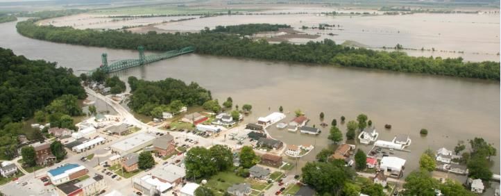
Illinois Waterway in Hardin, IL cresting at 40.2 ft. on June 4, 2019ILLINOIS WATERWAY ANNEX
Table of Contents
Section Title Page
Introduction 1
Section 1 – Geographic Description 2
Section 2 – Parties and Roles 3
USACE and USCG Equivalencies 4
Section 3 – Communications Plan 6
ILWW Contact List 9
ILWW Website List 11
Section 4 – Action Plan Tables 12
Table 1 – High Water 14
Table 2 – High Flow 30
Table 3 – Low Water 32
Table 4 – Ice 33
Section 5 – Risk Assessment 34
Appendix A – ILWW ATON Prioritization 2020 37
Appendix B – ILWW Quick Reference Stage Data 40
Appendix C – Fleet Area Management Guidelines 41
Appendix D – BNM Templates 42
Introduction
This appendix provides general information and target gauges to be used as a guideline for a crisis on the Illinois
Waterway (ILWW). Like a crisis on the Upper Mississippi River (UMR), it is the responsibility of the United
States Coast Guard (USCG), United States Army Corps of Engineers (USACE), and River Industry
representatives to meet and discuss conditions on the ILWW and to annually review the actions specified in the
plan. In Section 4 of this annex, the entire ILWW is broken into fourteen zones. Each zone is delineated by river
mile and is characterized by river stage, with three action phases (e.g., Watch, Action, and Recovery Phases)
described in the plan. A combination of reference gauges, historical data & known impact areas were used to
derive these zones.
1 ILWW WAP 2021 RevisionSection 1 – Geographic Description
The ILWW follows the channel of the Chicago Sanitary & Ship Canal from Chicago, then extends down the
Des Plaines River and finally the Illinois River to its mouth at the Mississippi River near Grafton, Illinois. It
also links to the calumet region via the Calumet Sag Channel. The waterway drops from 579.5’ above sea level
at Lake Michigan to 419’ above sea level at Grafton, Illinois. To accommodate this drop, eight locks and dam
sites were constructed along the waterway at Chicago, Lockport, Brandon Road, Dresden Island, Marseilles,
Starved Rock, Peoria, and La Grange.
HYDROLOGY AND IMPACT CONCERNS
Flooding on the ILWW is normally caused by high flows on the ILWW, by backwater from the UMR, or a
combination of both. The ILWW is said to "flood from the bottom up on most occasions.” Potential for
damage is usually associated with extreme or prolonged high water conditions which reduce levee freeboard,
saturate levees and increase seepage, while restricting access for repair. Along the middle section of the
ILWW, damage to homes is of concern when the impact of high water is multiplied by the surge and suction
caused by large commercial tows passing within close proximity of flooded homes. All of these issues must be
taken into consideration when deciding to implement operating restrictions or cease traffic. Additionally, not all
areas of concern are consistent throughout the entire length of the ILWW. In the upper reaches, safe navigating
conditions for tows and locks operating restrictions are the predominant considerations. In the mid-reaches, the
concerns are safe navigation and wake damage while, in the lower reaches, concern for levee conditions is
paramount.
LOW WATER & ICE CONDITIONS
Waterway management concerns also occur during low water and ice conditions on the ILWW. Low water is
of particular concern on the ILWW below Starved Rock Lock & Dam. This section of river is pooled by two
wicket dams designed to hold the river to pool level or slightly above. These dams do not have the capability of
holding more water in the pools. These pools are susceptible to rapid water level changes when a dam is placed
into operation or is dropped to allow for open passage. Groundings during low water conditions delay
commercial traffic, cause substantial damage to the navigation channel and can necessitate dredging. Ice
condition not only reduces water levels but causes ice to build up underneath barges causing them to "ground"
without ever touching the river bottom. Ice navigation can be very difficult as the ice removes navigation
buoys, causes ice gorges and damages the hulls of towing vessels and barges.
CONTROLLING FACTORS & WATERWAYS MANAGEMENT PLANNING
Under flood conditions, controlling factors are gauge readings at specific locales and locks. These are general
elevations at which water levels may cause impact upon levee conditions, damage homes or create unsafe
navigation conditions, as described in the “action” column of each zone. Well before water levels near or reach
these levels, the USCG in conjunction with USACE, and industry shall implement the “Watch Phase” of the
plan (which vary for each zone) e.g., establish communications to discuss the current and forecasted conditions.
These discussions should include an analysis of data, weather history & forecast, impact upon river
environment and commercial traffic requirements. Furthermore, general considerations such as levee
conditions, wake damage, bridge clearances and lock operating restrictions/closures shall be discussed. If the
conditions and time permit the USACE, USCG, and Illinois River Carrier’s Association (IRCA) may
observe test tows transiting an area, in order to determine if a river closure is warranted.
2 ILWW WAP 2021 RevisionSection 2 – Parties and Roles
U.S. Coast Guard (USCG)
USCG Sector Upper Mississippi River, with its principal office in St Louis, MO and a smaller Marine Safety
Detachment (MSD) office in Peoria, IL, is responsible for safety of navigation, security, and law enforcement
along the ILWW as far as mile marker (MM) 187.2; from that point, the responsibility belongs to USCG Sector
Lake Michigan working through USCG Marine Safety Unit (MSU) Chicago.
U.S. Army Corps of Engineers (USACE)
The USACE maintains two Lock and Dam facilities (TJ O’Brian and Lockport) under the supervision of the
Chicago District and an additional four Lock and Dam facilities along the ILWW, under the Supervision of their
Rock Island District Office on Arsenal Island in Rock Island, IL, St. Louis District Office in Downtown St.
Louis and a Project Office in Peoria, IL. To the extent possible, through management of these facilities, the
USACE maintains pool levels that are sufficient to accommodate commercial traffic on the river. The USACE
is required to deliver a 9-foot navigation channel.
U.S. Coast Guard District Eight Bridge Branch (dwb)
The Bridge Administration Program has a mandated responsibility to protect the public’s right of
navigation. Activities include determining location of navigation channel piers and issuing bridge
permits. They establish, revise and monitor drawbridge regulations and prescribe bridge lighting. Also,
Truman-Hobbs studies of unreasonable obstructive bridges are conducted on a nationwide basis.
Illinois River Carrier’s Association (IRCA)
IRCA plays a similar role to that of the River Industry Action Committee (RIAC), but keyed to only the ILWW,
whereas RIAC may overlap the major inland rivers.
River Industry Action Committee (RIAC)
RIAC is an association of companies and organizations who are stakeholders in the commercial industry on the
inland rivers. As the name suggests, they act in an advisory capacity on a wide range of issues affecting the
activities of the industry on the rivers. They provide an industry perspective to the USCG and the USACE on
matters such as high and low water, ice conditions, shoaling, marine accidents, etc.
Fleeting Facility Managers
Fleeting facility managers have a direct commercial interest in navigation conditions on the ILWW, and any
actions taken by the USCG or USACE in response to hazardous conditions that develop on the river. They can
play a valuable role in providing feedback to other parties on both river conditions and impact of proposed
actions of the USCG and USACE.
Designated Waterfront Facilities
Like the fleeting facility managers, the commercial interests of the designated waterfront facilities are directly
impacted by navigation conditions on the ILWW, and any actions taken by the USCG or USACE in response to
hazardous conditions that develop on the river. They can play a valuable role in providing feedback to other
parties on both river conditions and impact of proposed actions of the USCG and USACE.
State Emergency Managers
Hazardous conditions on the ILWW, particularly high water/flooding conditions, frequently involve state
emergency managers, as they become involved in responding to affected communities, and take a direct interest
in conditions or activities that can affect the levee systems that protect those communities.
Metropolitan Water Reclamation District (MWRD)
3 ILWW WAP 2021 RevisionThe mission of the MWRD is to protect the health and safety of the public in its service area. Water flow
within the District’s waterway system and the Lake Michigan discretionary diversion flow are controlled by
three inlet structures on Lake Michigan: Wilmette Pumping Station, Chicago River Controlling Works and T.J.
O’Brien Lock and Dam. There is normally some level of flow through the powerhouse, and there is some
limited flow through the lock as the chamber is filled and emptied. The main outlet from the Chicago Sanitary
and Ship Canal during high flows is a control structure on the right descending bank of the CSSC about 2 miles
upstream of the Lock.
4 ILWW WAP 2021 RevisionUSACE and USCG Equivalencies
USACE POSITION
DUTIES & DUTIES &
St. Louis District EQUALS USCG POSITION
RESPONSIBILITIES RESPONSIBILITIES
MM 0.0-80.0
Chief, Water Control
River Stage Forecast &
Operations
Control
(Supports Operations)
Operations Dredging
Channel Patrol & O&M
Project Manager, St.
Dredging Activities ILWW Chief, Waterways
Louis, MO
Management Oversees daily waterway
Division, Sector management and casualty
Operations Manager, Upper Mississippi operations
Rivers Project Office, Project Manager of ILWW River
Alton, IL
Chief, Emergency Flood Fight Response
Management Activities
REPORTS TO:
Chief, Prevention
Chief of Operations, St. Supervises Operations Department, Sector
Supervises operational issues
Louis District Managers Upper Mississippi
River
REPORTS TO:
Commander,
District Engineer, Supervises Chief of
Sector Upper Senior USCG officer in area
St. Louis District Operations
Mississippi River
REPORTS TO:
Division Engineer,
Commander, Eighth
Mississippi Valley Supervises District Engineer Senior USCG officer in District
Coast Guard District
Division
5 ILWW WAP 2021 RevisionUSACE POSITION
DUTIES & DUTIES &
Rock Island District EQUALS USCG POSITION
RESPONSIBILITIES RESPONSIBILITIES
MM 80.0-187.0
Chief Maintenance
Day to day O&M
Section and Chief L&D
ILWW Chief, Waterways
Section
Management Oversees daily waterway
Division, Sector management and casualty
Operations Manager, Upper Mississippi operations
Supervises Section Chiefs River
Illinois Waterway
REPORTS TO:
Chief, Prevention
Chief of Operations, Supervises Operations Department, Sector
Supervises operational issues
Rock Island District Manager Upper Mississippi
River
REPORTS TO:
Commander, Sector
District Engineer, Rock Supervises Chief of
Upper Mississippi Senior USCG officer in area
Island District Operations
River
REPORTS TO:
Division Engineer,
Commander, Eighth
Mississippi Valley Supervises District Engineer Senior USCG officer in District
Coast Guard District
Division
USACE POSITION
DUTIES & DUTIES &
Rock Island District EQUALS USCG POSITION
RESPONSIBILITIES RESPONSIBILITIES
MM 187.1-327.0
Chief Maintenance
Day to day O&M
Section and Chief L&D
ILWW
Section
Waterways Division, Oversees daily waterway
Marine Safety Unit management and casualty
Operations Manager, Chicago operations
Supervises Section Chiefs
Illinois Waterway
REPORTS TO:
Commanding
Chief of Operations, Supervises Operations
Officer, Marine Supervises operational issues
Rock Island District Manager
Safety Unit Chicago
Commanding
Chief of Operations Supervises Operations
Officer, Marine Supervises operational issues
USACE Chicago District Manager
Safety Unit Chicago
REPORTS TO:
District Engineer, Rock Supervises Chief of Commander, Sector
Senior USCG officer in area
Island District Operations Lake Michigan
REPORTS TO:
Division Engineer, Commander,
Mississippi Valley Supervises District Engineer Ninth Coast Guard Senior USCG officer in District
Division District
6 ILWW WAP 2021 RevisionSection 3 – Communications Plan
Initiation of Communications Plan – This section provides guidance on the methods of communicating and
receiving information. The USCG and maritime industry all carefully monitor river conditions and levels.
When any of the conditions warrant attention (high water, low water, high flow, ice or any other hazardous
condition), any ILWW stakeholder can request a conference call by contacting the USCG Sector Upper
Mississippi River, Waterways Management Division Chief, USCG MSU Chicago, or the Chair of IRCA. The
Chair of IRCA and the USCG will discuss the concerns with the appropriate USACE contacts to decide if a
phone conference is necessary. If further discussion is needed, the members listed on the following pages of
this section, to include Industry and State personnel, will be contacted via email or phone call. The IRCA chair
will contact those members of their respective organizations. A teleconference will be set up to confer with all
parties on possible measures to take and joint courses of action using the guidance from this annex as a basis to
make a determination. During times when zones have reached the “action” phase, representatives of the
Captain of the Port Upper Mississippi River and the Commanding Officer (or Executive Officer) of MSU
Chicago shall be present during telephone conference calls. By conferring frequently with all ILWW
stakeholders a joint action plan to safely navigate during the condition that warranted initiating the
communications plan will be developed. The action plan will then be communicated to all ILWW stakeholders
and the public using Broadcast Notice to Mariners, Homeport, press releases if appropriate, and, if time permits,
Local Notice to Mariners.
Phone Conference Call Agenda:
I. Roll Call by Phone Conference Host
II. Protocol for Conference Call
III. Open Statement by Chairman or Co-Chairman of IRCA/RIAC on Issues
IV. Weather Forecast by NWS or USACE
V. River Stage Forecast by USACE
VI. Channel Report for Area Of Concern by USACE Dredging Section
VII. Status of Dredging and Next Scheduled Locations
VIII. USCG Report on Advisories and Remarks
IX. USCG Buoy Tender Report on Channel Conditions
X. River Condition Report and Issues of Conference Call by Industry
XI. Discussion of Issues on Current Situations
XII. Assessment, Actions to Be Taken
XIII. Closing
All Agencies & Organizations: To ensure effective interagency cooperation during periods of coordinated
response to high and low water, or other hazardous river conditions, stakeholder organizations are advised to
maintain active and ongoing communications with one another during normal river conditions and while
planning together for joint response activities. This will greatly facilitate speedy and effective
communications under the pressure of responding to an event.
Vessel to Vessel and Vessel to Shore Communications: VHF communications on the ILWW are handled by
the communications centers at the Sector Upper Mississippi River Command Center and Sector Lake Michigan
Integrated Command Center.
The Sector Upper Mississippi River Command Center is located in the Robert A. Young Federal Building in St.
Louis, MO and is responsible for receiving information on the ILWW MM 0-187.0.
7 ILWW WAP 2021 RevisionThe Sector Lake Michigan Command Center is located in Milwaukee, WI and is responsible for receiving
information on the ILWW MM 187.0-333.4.
NOTIFICATIONS:
Refer to pages 9 – 11 for contact list.
U. S. Coast Guard:
The USCG maintains a 24/7 live watch at its Command Centers in St. Louis, MO and Milwaukee, WI.
Hazardous river conditions are monitored by Command Center personnel, as well as Sector Duty Officers in St.
Louis, MO and Milwaukee, WI and are reported, as appropriate, to the Sector Commanders. As conditions
dictate, the Command Centers will release Broadcast Notices to Mariners (BNM) or Urgent Marine Information
Broadcasts (UMIB) with safety advisories, safety zones, or river closures. As noted above, these waterways
control measures are determined in consultation with the USACE and representative of the river industry.
USCG MSU Chicago’s Area of Responsibility covers MM 187.2-333.4.
**For reports of high water and high flows that require action (BNM) in MSU Chicago’s area, call the Sector
Lake Michigan Command Center.**
The USCG District Eight Bridge Branch manages all bridges within the Sector Upper Mississippi River zone.
Any issues involving a bridge should be reported to the Bridge Branch or Sector Command Centers.
USACE Rock Island District:
During Normal Work Hours
During periods of hazardous river conditions the USACE field offices work closely with river users and the
basin communities. The field office staff reports the river conditions and impacts to their respective District
Office and Mississippi Valley Division (MVD) Point of Contact. The USACE has three district offices
responsible for the ILWW; the Chicago District, Rock Island District and the St. Louis District. The field staff
report to district staff persons within Operations Division and Emergency Management Division. Operations
Division staff will inform the District Water Control or Water Management Offices, the district leadership and
the District Commander. They will also notify Division Water Management. They will then contact
appropriate staff person in the Division Office, who will notify, the appropriate Division leadership and the
Division Commander. The District Operations staff will coordinate with the Coast Guard throughout the
hazardous period. When river conditions become too hazardous for safe navigation or if continuing navigation
causes an unsafe condition such as causing levee erosion or interfering with flood fighting, etc., the USACE
through the appropriate District Commander will make recommendations to the Coast Guard to issue safety
zone restrictions or river closures. Likewise as river conditions improve the USACE through the appropriate
District Commander will make recommendations to remove the safety zone restrictions or reopen the river to
navigation.
After Normal Work Hours, Weekends and Holidays
Below is the most up-to-date contact list with work and cell phone numbers, which are maintained by USACE
staff responsible for emergency response to hazardous river conditions.
River users may report hazardous conditions to the nearest Lock and Dam. The Lockmaster will
report the hazardous conditions and possible impacts to Water Control Personnel and River Project
Manager.
8 ILWW WAP 2021 Revision USACE will report hazardous conditions to USCG.
USACE will coordinate with USCG for issuance of safety zones.
USACE St. Louis District:
During Normal Work Hours
During periods of hazardous river conditions the USACE works closely with river users and the basin
communities. River users may report hazardous conditions to the nearest Lock and Dam. The Lockmaster will
report the hazardous river conditions and impacts to their District Office Point of Contact. Once the report of
the hazardous condition is received in the District Office the following persons will be informed: District Water
Control Manager, Emergency Management Manager, Operations Dredging Project Manager, Rivers Project
Office Manager, the Chief of Operations, District Deputy Engineer and the District Commander. The District
team including Water Control, Emergency Management and Operations staff will coordinate with the Coast
Guard throughout the hazardous period. When river conditions become too hazardous for safe navigation or if
continuing navigation causes an unsafe condition such as causing levee erosion or interfering with flood
fighting, etc., the USACE through the District Commander will make recommendations to the Coast Guard to
issue safety zone restrictions or river closures. Likewise as river conditions improve the USACE through the
appropriate District Commander will make recommendations to remove the safety zone restrictions or reopen
the river to navigation.
After Normal Work Hours, Weekends and Holidays
Below is the most up-to-date contact list with work and cell phone numbers, which are maintained by USACE
staff responsible for emergency response to hazardous river conditions.
River users may report hazardous conditions to the nearest Lock and Dam. The Lockmaster will
report the hazardous conditions and possible impacts to Water Control Personnel and River Project
Manager.
USACE will report hazardous conditions to USCG.
USACE will coordinate with USCG for issuance of safety zones.
Illinois Emergency Management Agency (IEMA):
In the event of an incident occurring on the ILWW which could involve the State of Illinois, immediate contact
should be made with the IEMA telecommunications center. This will alert the Operations staff which enables
the IEMA to monitor and pre-position resources if circumstances dictate. It is at this initial call number that the
agencies equipped to provide a response; mitigation and recovery are quickly notified. Periodic status reports to
the telecommunications center allows the IEMA staff time to prepare for management procedures.
9 ILWW WAP 2021 RevisionILWW Contact List
IRCA
Chair – Jeremy Tardy (270) 933-8056
jeremy.tardy@bargeacbl.com
RIAC
(314) 803-4644 (cell)
St. Louis District – Bernie Heroff (877) 855-7266
bernard.heroff@adm.com
(217) 257-1749
Rock Island District – Casey Herschler
casey.herschler@gmail.com
(651) 292-9293
St. Paul District - Lee Nelson (651) 260-0185 (cell)
lee@ursi.net
USCG Sector Upper Mississippi River; St. Louis, MO
Command Center (24/7) (314) 269-2332
STL-SMB-SECUMRCC@uscg.mil
Sector Commander – CAPT Richard Scott (314) 269-2600
richard.m.scott@uscg.mil
Prevention Department Chief – LCDR Dan Every (314) 269-2568
daniel.j.every@uscg.mil
Waterways Management Division Chief – LCDR Steph Moore (314) 269-2560
stephanie.r.moore@uscg.mil
Waterways Management Division Watch stander (24/7) (319) 520-8556
SUMRWaterways@uscg.mil
USCG Marine Safety Detachment Peoria (309) 694-7779
USCG Sector Lake Michigan; Milwaukee, WI
Command Center (24/7) (414) 747-7182
USCG Marine Safety Unit Chicago
Commanding Officer – CDR Randy Preston (630) 986-2155
randy.l.preston@uscg.mil
Waterways Management Division (630) 986-2131
(630) 341-8320 (cell)
D09-SMB-MSUChicago-WWM@uscg.mil
Command Duty Officer (24/7) (630) 336-0281
USCG Eighth District Bridge Branch; St. Louis, MO
During normal working hours (314) 269-2378
(314) 299-4757
STL-DG-ALL-D8-DWB@uscg.mil
After normal working hours, call USCG Sector Upper Mississippi River Command Center
10 ILWW WAP 2021 RevisionILWW Contact List
USACE Chicago District
24 Hour Contact Phone Number (312) 846-5330
Timothy Kroll 312-846-5484 (cell)
Supervisor, Waterway Project Office Tim.kroll@uscace.army.mil
Michael Walsh 815-510-0361 (cell)
Chief Waterway Project Office Michael.j.walsh@usace.army.mil
William “Paul” Mazzeno 312-846-5552 (office)
Chief Operations & Regulatory Division 872-227-4511 (cell)
Willam.p.mazzeno@usace.army.mil
Website https://www.lrc.usace.army.mil/
USACE Rock Island District
24 Hour Contact Phone Number (309) 794-4200
Mississippi River Project/Channel Maintenance Office
Aaron Dunlop (309) 794-4500
(563) 209-0554 (cell)
Aaron.D.Dunlop@USACE.army.mil
Bob Castro (309) 794-4580
(309) 749-7214
robert.v.castro@usace.army.mil
John Klingman (Dredging) (309) 794-5240
(309) 738-2257 (cell)
jon.a.klingman@usace.army.mil
Chief, Operations Division, Tom Heinold (309) 794-5401
Thomas.D.Heinold@USACE.army.mil
Deputy, chief Operations Division Brad Houzenga (309) 794-5501
Brad.C.Houzenga@USACE.army.mil
USACE St. Louis District
Emergency Management Office: (314) 331-8605
John Osterhage (314) 331-8569
john.l.osterhage@usace.army.mil
Water Control:
(314) 331-8330
Joan Stemler (314) 630-6292 (cell)
joan.m.stemler@usace.army.mil
(314) 331-8412
Konrad Faries (314) 349-8757 (cell)
Konrad.W.Faries@usace.army.mil
(314) 331-8337
Russel Errett (314) 681-7625 (cell)
russell.j.errett@usace.army.mil
(314) 331-8351
Liz Norrenberns (314) 277-5825 (cell)
elizabeth.a.norrenberns@usace.army.mil
(314) 331-8348
Leonard Hopkins
(314) 799-3458 (cell)
11 ILWW WAP 2021 RevisionILWW Contact List
leonard.e.hopkins@usace.army.mil
River Project:
(636) 899-0044
Andy Schimpf (314) 630-6280 (cell)
andrew.c.schimpf@usace.army.mil
(636) 899-0072
Matthew Chlibec (636) 288-8615 (cell)
Matthew.j.chlibec@usace.army.mil
(314) 952-5197
Dredging Operations – Lance Engle
lance.engle@usace.army.mil
Locks and Dams
LaGrange (217) 225-3317
Peoria (309) 699-6111
Starved Rock (815) 667-4114
Marseilles (815) 795-2593
Dresden (815) 942-0840
Brandon Road (815) 744-1714
Lockport (815) 838-0536
T.J. O’Brien (773) 646-2183
Chicago (312) 787-4795
Illinois Emergency Management Agency (IEMA)
IEMA Telecommunications Center (217) 782-7860
(815) 433-7161
IEMA Region 3
(815) 587-4483
(217) 782-0922
IEMA Region 6
(217) 836-1761
IEMA Region 8 (618) 394-2233
IL Department of Natural Resources Law Enforcement (217) 782-3637
12 ILWW WAP 2021 RevisionILWW Website List
INTERNET SITE PURPOSE ADDRESS
USACE Rock Island District https://www.mvr.usace.army.mil/
USACE St. Louis District https://www.mvs.usace.army.mil/
USACE Chicago District https://www.lrc.usace.army.mil/
https://www.atlanticarea.uscg.mil/Our-
Organization/District-9/Ninth-District-
Units/Sector-Lake-Michigan/Units/MSU-
USCG MSU Chicago Chicago/
https://homeport.uscg.mil/port-directory/lake-
michigan
https://www.atlanticarea.uscg.mil/Our-
Organization/District-8/District-Units/Sector-
Upper-Mississippi-River/
USCG Sector Upper Mississippi River
https://homeport.uscg.mil/port-
directory/upper-mississippi-river-(st-louis)
13 ILWW WAP 2021 RevisionSection 4 – Action Plan Tables
The actions to be taken during High Water, Low Water, High Current, and Ice conditions are described in the following Action Plan Tables.
This Information is Applicable to all Tables
Issue advisories (consider BNM, LNM, MSIB, and/or AIS-Geographic Notice) or establish safety zones, if deemed necessary, to indicate extreme
low water, high water, high flow, or ice conditions.
In the event of an unexpected river closure, the following steps should be considered prior to reopening the river as appropriate:
Assess need/consider conducting test tows for limited operations during closures and in anticipation of reopening. Conduct test tows if
necessary for potential problem areas. USACE, USCG, IRCA, and Levee Districts to be included in discussion of and witnessing test
tows.
Develop and initiate recovery plan to clear the queue.
USCG and USACE will typically reset buoys in those narrow channel locations within reach and continue an increased level of channel
reconnaissance to ensure vessel traffic is able to transit safely. USCG, USACE, and IRCA will coordinate vessel navigation protocols in
situations where channel widths are temporarily reduced to below normal operating standards.
USCG and USACE will coordinate the use of electronic aids to navigation, particularly in areas of emergent shoaling.
IRCA will create/manage a queue of vessels meeting the maximum possible safe depth for northbound and southbound traffic.
Consider draft limits, tow sizes, and helper boats.
Evaluate fleet dimensions.
Be aware of shifting channels.
Emergency dredging may be required at some locations.
All the phases and actions listed in the tables below can be modified based on coordination between the USCG, USACE, and industry.
14 ILWW WAP 2021 RevisionVessels equipped with Azipods (“Z Drive”) may generally be considered to have 20 percent more than their actual horsepower rating for DOWN
BOUND tows.
15 ILWW WAP 2021 RevisionACTION PLAN TABLE 1 – HIGH WATER
This table contains the actions to be followed as the water rises to specific levels set for each zone. As the phases change from Normal to Watch, Action, and then Recovery, the
following procedures apply to ALL zones. Specific phase trigger points, unique concerns, and additional actions for specific zones are listed in Table 1a.
Normal Operations (Rising Water)
o Monitor river gauges frequently
o As stage rises toward flood stage, consider the need to initiate communications plan (refer to Section 3)
High Water (Watch Phase)
o Initiate communications plan (refer to Section 3)
o Issue advisory that indicates high water and drift potential
o Advise the use of caution and minimization of wake
o Consider tow restrictions and HP requirements
o Consider the use of AIS-Geographic Notices to alert mariners to areas of high water
o Consider issuance of advisories (BNM, MSIB) for advanced notice of river closure and no wake thresholds
o Discuss mooring arrangements and dangers of down-streaming
Extreme High Water (Action Phase)
o Analyze watch phase requirements, high current reports, flood fighting reports, impacted river reaches, towboat positions, and levee conditions
o Consider establishment of Safety Zone to close river or Regulated Navigation Area to impose vessel operational restrictions. If established, use BNM, MSIB,
and/or AIS-Geographic Notices to inform mariners. Consider issuing press releases and distributing MSIBs to State/County EOC and State Boating Law
Administrators to ensure awareness of recreational boaters.
o Develop plan for reopening river and IRCA management of vessel queue, if needed
o In addition to watch phase requirements,
Discourage or prohibit recreational vessel traffic
Prohibit laying up on levees and pushing in to river banks along which railroad tracks are charted in close proximity to rivers edge
Allow local fleeting to continue
Advise caution due to swift current
Extreme High Water (Recovery Phase)
o Analyze watch phase requirements, high current reports, flood fighting reports, impacted river reaches, towboat positions, and levee conditions
o Determine which action advisories need to remain in place or can be removed
o Monitor conditions related to Safety Zone or Regulated Navigation Area necessity, if established
Evaluate river conditions for river reopening
Initiate IRCA’s plan for clearing the queue
o Consider the use of AIS broadcasted virtual buoys and/or geographic notices in areas of emergent shoaling
High Water (Recovery Phase)
o Update / issue advisory to indicate high water and use of caution
o Report hazardous conditions to appropriate Coast Guard office (refer to Sections 2 & 3)
16 ILWW WAP 2021 RevisionACTION PLAN TABLE 1 – HIGH WATER
o Monitor river gauges frequently
o Monitor conditions related to Safety Zone or Regulated Navigation Area; determine threshold for cancellation
o If stage rises, consider the need to initiate communications plan (refer to Section 3)
Normal Operations (Falling / Stable Water)
o Issue final advisory that indicates a return to Normal Operations
17 ILWW WAP 2021 RevisionACTION PLAN TABLE 1a – HIGH WATER
CRITICAL LOCATION TRIGGER
TREND DESCRIPTION PHASE ACTION
DESCRIPTION READING
Illinois Waterway 18’ and below Rising Normal Operations No additional actions
Zone 1 High Water
18’ to 22’ Rising Watch No additional actions
Damage begins in
Miles 0.0 to 9.9 Grafton, IL at 18’
Extreme High Water
22 and above’ Rising Action No additional actions
Rte. 100 closed @ 24.7’
Reference Gauge:
Grafton (GRFI2)
Stable Extreme High Water
MM 0.0 Crest to 22’ or Recovery No additional actions
Falling Stable or falling
Flood Stage:
18’ / 421.8’ MSL 22’ to 18’ Falling High Water Recovery No additional actions
(Mean Sea Level)
MSL Zero Gauge:
18’ and below Falling Normal Operations No additional actions
403.8’
18 ILWW WAP 2021 RevisionACTION PLAN TABLE 1a – HIGH WATER
CRITICAL LOCATION TRIGGER
TREND DESCRIPTION PHASE ACTION
DESCRIPTION READING
25’ and below Rising Normal Operations No additional actions
Illinois Waterway
High Water Vessel operators must closely monitor river level forecasts and begin
Zone 2 planning for possibility of no wake/closures; planning should include
25’ to 33’ Rising Watch
Damage begins in Hardin ability to have vessels clear of the zone prior to closure threshold.
@ 28.6’
Miles 10.0 to 49.9 Consider closure for entire zone when the stage is 35.5 ft. and above on
Extreme High Water the Hardin gauge. Vessel operators should ensure they are clear of the
zone ahead of the closure threshold. Consider allowing vessels to clear
Flooding in Kampsville & the zone, continue fleet monitoring, and use of test tows on a case-by-
33’ and above Rising Hardin, Bluffdale levees Action case basis.
overtopped @ 37.6’
Reference Gauge:
Nutwood levee overtopped Consider no wake advisory for entire zone when the stage is 34.0 to
Hardin (HARI2) @ 33.5’ 35.5 ft. on the Hardin gauge
MM 21.5
Stable Extreme High Water
Flood Stage: Crest to 33’ or Recovery No additional actions
25’ / 425.0’ MSL Falling Stable or falling
MSL Zero Gauge: 33’ to 25’ Falling High Water Recovery No additional actions
400.0’
25’ and below Falling Normal Operations No additional actions
19 ILWW WAP 2021 RevisionACTION PLAN TABLE 1a – HIGH WATER
CRITICAL LOCATION TRIGGER
TREND DESCRIPTION PHASE ACTION
DESCRIPTION READING
14’ and below Rising Normal Operations No additional actions
Vessel operators must closely monitor river level forecasts and begin
Illinois Waterway High Water planning for possibility of no wake/closures; planning should include
14’ to 23’ Rising Watch ability to have vessels clear of the zone prior to closure threshold.
Main Rd in Valley City
Zone 3 overtopped
Consider setup of unified command with an ICP at Meredosia including
Miles 50.0 to 80.2 USCG, USACE, IEMA, and Industry.
Consider closure for entire zone when the stage is 26.0 ft. and above on
Extreme High Water the Meredosia gauge and/or 24.0 ft. and above on the Valley City
gauge. Vessel operators should ensure they are clear of the zone ahead
23’ and above Rising Action of the closure threshold. Consider allowing vessels to clear the zone,
Reference Gauge: Damage to buildings in
Montezuma & Florence continue fleet monitoring, and use of test tows on a case-by-case basis.
Meredosia (MROI2) at 24’
MM 70.8 Consider no wake advisory for entire zone when the stage is 25.0 to
26.0 ft. on the Meredosia gauge and/or 23.0 to 24.0 ft. on the Valley
City gauge.
Flood Stage:
14’ / 432.0’ MSL Stable Extreme High Water
Crest to 23’ or Recovery No additional actions
MSL Zero Gauge: Falling Stable or falling
418.0’
23’ to 14’ Falling High Water Recovery No additional actions
14’ and below Falling Normal Operations No additional actions
20 ILWW WAP 2021 RevisionACTION PLAN TABLE 1a – HIGH WATER
CRITICAL LOCATION TRIGGER
TREND DESCRIPTION PHASE ACTION
DESCRIPTION READING
14’ and
Rising Normal Operations No additional actions
below
Vessel operators must closely monitor river level forecasts and begin
High Water planning for possibility of no wake/closures; planning should include
ability to have vessels clear of the zone prior to closure threshold.
Illinois Waterway 14’ to 22’ Rising Seepage problems Watch
initially, damage to
buildings in Browning @
Zone 4 22’
Extreme High Water
Miles 80.3 to 101.9 Damage in Frederick &
Browning @ 27’ Consider closure for entire zone when the stage is 27.0 ft. and above on
the Beardstown gauge. Vessel operators should ensure they are clear of
Crane Creek Levee (83.8- the zone ahead of the closure threshold. Consider allowing vessels to
84.9) Design Exceeded @
Reference Gauge: 22’ and above Rising 27.5’, Overtop @ 30.5’ Action
clear the zone, continue fleet monitoring, and use of test tows on a case-
Beardstown (BEAI2) by-case basis.
Beardstown Levee (79.0-
MM 88.6 89.0) Design Exceeded @
Consider no wake advisory for entire zone when the stage is 26.0 to
30.0’, Overtop @ 33.0’
27.0 ft. on the Beardstown gauge
Coal Creek Levee (84.9-
Flood Stage: 91.6) Design Exceeded @
14’ / 433.9’ MSL 30.1’, Overtop @ 33.1’
Stable Extreme High Water
MSL Zero Gauge: Crest to 22’ or Recovery No additional actions
419.9’ Falling Stable or falling
Note: At LaGrange Lock:
Lower wall elevation- 432.0
22’ to 14’ Falling High Water Recovery If Open Pass is not allowed and the water elevation is at 18.5’ (432.0
MSL) lock out of operation until river falls to 431.5 MSL and to
safe operating levels.
21 ILWW WAP 2021 Revision14’ and
Falling Normal Operations No additional actions
below
ACTION PLAN TABLE 1a – HIGH WATER
CRITICAL LOCATION TRIGGER
TREND DESCRIPTION PHASE ACTION
DESCRIPTION READING
14’ and below Rising Normal Operations No additional actions
Illinois Waterway Vessel operators must closely monitor river level forecasts and begin
planning for possibility of no wake/closures; planning should include
14’ to 20’ Rising High Water Watch
Zone 5 ability to have vessels clear of the zone prior to closure threshold.
Miles 102 to 128.9 Extreme High Water
Big Lake Levee (102.6-
108.3) Design Exceeded
@ 21’ minimize wake between MM 127.5-128.5
@ 24.2’, Overtop @ 27.2’
Consider closure for entire zone when the stage is 26.0 ft. and above on
Lacey, Langellier, Kerton the Havana gauge. Vessel operators should ensure they are clear of the
Reference Gauge: Valley, West Mantanzas zone ahead of the closure threshold. Consider allowing vessels to clear
Levee (111.8-1119.6)
Havana (HAVI2) 20’ and above Rising Design Exceeded @ 26.3’, Action the zone, continue fleet monitoring, and use of test tows on a case-by-
MM 118.4 Overtop @ 29.3’ case basis.
Thompson/Emiquon Consider no wake advisory for entire zone when the stage is 24.5 to
Levee (120.8-125.9)
Flood Stage: Design Exceeded @ 23.1’, 26.0 ft. on the Havana gauge
14’ / 438.4’ MSL Overtop @ 26.1’
Liverpool Levee (126.3-
128.2) Design Exceeded
MSL Zero Gauge: @ 23.9’, Overtop @ 26.9’
424.4’ Stable Extreme High Water
Crest to 20’ or Recovery No additional actions
Falling Stable or falling
20’ to 14’ Falling High Water Recovery No additional actions
22 ILWW WAP 2021 Revision14’ and below Falling Normal Operations No additional actions
23 ILWW WAP 2021 RevisionACTION PLAN TABLE 1a – HIGH WATER
CRITICAL LOCATION TRIGGER
TREND DESCRIPTION PHASE ACTION
DESCRIPTION READING
13’ and below Normal Operations No additional actions
Illinois Waterway High Water
Advise the use of caution and minimize wake between MM 136-138
13’to 16.4’ Rising @16.4’ tow wave action Watch
(Copperas Creek).
Zone 6 may affect houses at
Copperas Creek
Miles 129 to 145.5 Extreme High Water
@ 18.2’ four houses
surrounded by water
@ 20’ 1st floor of houses
impacted by tow wake
Reference Gauge:
East Liverpool Levee
Copperas Creek (128.4-131.7) Design
(COPI2) 16.4’ and above Rising Exceeded @ 23.9’, Action No additional actions
Overtop @ 26.9’
MM 136.8 Spring Lake Levee
(133.9-147.8) Design
Exceeded @ 23.1’,
Flood Stage: N/A Overtop @ 26.1’
Banner Special Levee
Normal Pool: (143.9-145.5) Design
Exceeded @ 23.9’,
1.5’ / 429.5’ MSL Overtop @ 26.9’
Stable Extreme High Water
MSL Zero Gauge: Crest to 16.4’ or Recovery No additional actions
428.0’ Falling Stable or falling
16.4’ to 13’ Falling High Water Recovery No additional actions
24 ILWW WAP 2021 Revision13’ and below Falling Normal Operations No additional actions
ACTION PLAN TABLE 1a – HIGH WATER
CRITICAL LOCATION TRIGGER
TREND DESCRIPTION PHASE ACTION
DESCRIPTION READING
18’ and below Normal Operations No additional actions
Vessel operators must closely monitor river level forecasts and
Illinois Waterway 18’ to 22’ Rising High Water Watch
begin planning for possibility of no wake/closures; planning
should include ability to have vessels clear of the zone prior to
closure threshold.
Zone 7 Extreme High Water @ 22’ minimize wake between MM 166.5-178
Damage begins in buildings @ 24.1’ minimize wake between MM 162-179
Miles 145.6 to 187.0 in Rome @ 23’
Spring Lake Levee (133.9-
Avoid pushing in near MM 167 RDB due to railroad track in
147.8) Design Exceeded @ close proximity to bank line (see charted caution area for
27.0’, Overtop @ 30.0’ detailed location); risk of collision with train exists at higher
river levels
Pekin LaMarsh Levee (149.6-
Reference Gauge: 22’ and above Rising 155.2) Design Exceeded @ Action
25.7’, Overtop @ 28.7’
Peoria (PIAI2) Consider closure for entire zone when the stage is 27.0 ft. and
MM 164.6 East Peoria Levee (159.3- above on the Peoria gauge. Vessel operators should ensure they
161.9) Design Exceeded @ are clear of the zone ahead of the closure threshold. Consider
30.8’, Overtop @ 33.8’ allowing vessels to clear the zone, continue fleet monitoring, and
Flood Stage: Greater Peoria Sanitary
use of test tows on a case-by-case basis.
18’ / 446.4’ MSL District Levee (159.8-160.3)
Design Exceeded @ 28.3', Consider no wake advisory for entire zone when the stage is 25.5
Overtop @ 31.3’ to 27.0 ft. on the Peoria gauge
MSL Zero Gauge:
Stable High Water
428.39’ Crest to 22’ or Recovery No additional actions
Falling Stable or falling
22’ to 18’ Falling High Water Recovery No additional actions
25 ILWW WAP 2021 RevisionNote: At Peoria Lock:
Lower wall elevation- 440.0
18’ and below Falling Normal Operations Out draft sign opens at 3’ of Dam Gate opening
When using the pass the lock will be out of operation until wickets are
raised at approximately 438.50.
ACTION PLAN TABLE 1a – HIGH WATER
CRITICAL LOCATION TRIGGER
TREND DESCRIPTION PHASE ACTION
DESCRIPTION READING
5’ Below
Rising Normal Operations No additional actions
Illinois Waterway Flood Stage
High Water
Zone 8
23’ to 27.4’ Rising Damage begins to Watch No additional actions
buildings in Sparland @
Miles 187.1 to 199.9 28’
Extreme High Water
27.5’ and
Rising Action No additional actions
above Homes in Henry begin to
flood at 29.6’
Reference Gauge:
Henry (HNYI2)
Stable High Water
MM 196.1 Crest or Recovery No additional actions
Falling Stable or falling
Flood Stage:
23’ / 448.9’ MSL 23’ Flood
Falling High Water Recovery No additional actions
Stage
MSL Zero Gauge:
425.88’ 5’ Below
Falling Normal Operations No additional actions
Flood Stage
26 ILWW WAP 2021 Revision27 ILWW WAP 2021 Revision
ACTION PLAN TABLE 1a – HIGH WATER
 CRITICAL LOCATION     TRIGGER
                                     TREND       DESCRIPTION                  PHASE                                     ACTION
    DESCRIPTION        READING

                        5’ Below
                                     Rising     Normal Operations                                                 No additional actions
                       Flood Stage

                                                    High Water
                        20’ to 22’             Damage begins due to
                                     Rising                                    Watch                              No additional actions
                       Flood Stage             agricultural flooding @
 Illinois Waterway                             20’

                                                                                         Avoid pushing in near MM 222 RDB due to railroad track in close
      Zone 9                                                                             proximity to bank line (see charted caution area for detailed
                                                                                         location); risk of collision with train exists at higher river levels
Miles 200.0 to 230.9                                                                     At Starved Rock Lock: Ref: Lock Gauges
                                                                                         Out draft sign out at 15.5’ gate opening
                                                                                         Upper wall elevation – 463.5
                        22.1’ and                                                        Lower wall elevation – 458.5
                                     Rising    Extreme High Water              Action
                         above                                                           At a tail reading of 457.50 all tows over 70’ wide must have loads on
Reference Gauge:                                                                         land wall side.
                                                                                         At a tail reading of 458.50 restrictions on double and down bound set
La Salle (LSLI2)                                                                         overs. Lower wall is submerged.
MM 224.7                                                                                 Lock is out of operation at 461.50 due to water in the machinery pits.
                                                                                         Dam out of operation at 240’ gate
                                                                                         Hydro plant out of operation at 455.0
Flood Stage:
20’ / 450.0’ MSL
                                     Stable         High Water
                          Crest        or                                     Recovery                            No additional actions
MSL Zero Gauge:                      Falling      Stable or falling
430.0’
                        20’ Flood
                                     Falling        High Water                Recovery                            No additional actions
                          Stage

                        5’ Below
                                     Falling    Normal Operations                                                 No additional actions
                       Flood Stage

                                                                         28                                                 ILWW WAP 2021 Revision
ACTION PLAN TABLE 1a – HIGH WATER
CRITICAL LOCATION TRIGGER
TREND DESCRIPTION PHASE ACTION
DESCRIPTION READING
5’ Below
Rising Normal Operations No additional actions
Flood Stage
20.0’ to 22’ Rising High Water Watch No additional actions
Illinois Waterway
At Marseilles Lock: (Ref Lock Gauges)
Zone 10 Out draft sign out at 15’of dam gate opening
Upper wall elevation – 486.0
Lower wall elevation – 466.7
At a tail reading of 465.70 all tows over 70’ wide must have loads on the land wall side.
Miles 231.0 to 244.6 At a tail reading of 466.7 restrictions on doubles and down bound set overs. Lower wall is
Extreme High
Water submerged.
Lock is out of operation at 483.50 due to water in the machinery pits.
22.1’ and Ottawa Township HS
Action Dam out of operation at 72’.
Rising
Starved Rock Pool above Levee (239.7-240.5) *NOTE: For the area in the immediate vicinity of Marseilles Dam and the entrance to
Design Exceeded @ Marseilles Canal, MM 247.0:
471.1’, Overtopped @ When the dam gate opening reaches 20-25 feet, there is a very strong out draft and
Reference Gauge: 474.1’ NGVD 1929 mariners need to use extreme caution when transiting the area. Some larger tows consider
options to approaching this area, such as holding transit until flows reduce or changing
Marseilles (MRSI2) pilots.
MM 246.5 When the dam gate opening reaches higher than 25 feet there is an extremely strong out
draft and mariners need to use extreme caution when transiting the area, ensuring
adequate expertise and resources are available to safely accomplish transit.
Flood Stage:
20’ / 472.9’ MSL
Stable High Water
MSL Zero Gauge: Crest or Recovery No additional actions
452.9’ Falling Stable or falling
20’ Flood
Falling High Water Recovery No additional actions
Stage
5’ Below
Falling Normal Operations No additional actions
Flood Stage
29 ILWW WAP 2021 RevisionACTION PLAN TABLE 1a – HIGH WATER
CRITICAL LOCATION TRIGGER
TREND DESCRIPTION PHASE ACTION
DESCRIPTION READING
5’ Below NOTE: See footnote regarding Marseilles Canal under High Flows,
Rising Normal Operations
Flood Stage Zones 1-12.”
Illinois Waterway 13.0’ to 15.9’ Rising High Water Watch No additional actions
Zone 11 At Dresden Island Lock: (Ref lock Gauges)
Out draft sign out at 15’ of dam gate opening
Upper wall elevation – 509.44
Miles 244.7 to 271.5 Lower wall elevation – 496.53
At a tail reading of 494.53 all tows over 70’ wide must have loads on
the land wall side.
Marseilles Pool At a tail reading of 496.53 restrictions on doubles and down bound set
Extreme High Water overs. Lower wall is submerged.
Lock out of operation at 505.44 due to water in the gate machinery pits.
Reference Gauge: 16.0’ and Roads flood @ 16’ Dam out of operation at 144’
Rising Action
Morris (MORI2) above
Damage to homes near *NOTE: For the area in the immediate vicinity of Marseilles Dam and the
MM 263.1 MM 263 @ 20’ entrance to Marseilles Canal, MM 247.0:
When the dam gate opening reaches 20-25 feet, there is a very strong out draft
and mariners need to use extreme caution when transiting the area. Some larger
Flood Stage: tows consider options to approaching this area, such as holding transit until
16’ / 494.5’ MSL flows reduce or changing pilots.
When the dam gate opening reaches higher than 25 feet there is an extremely
strong out draft and mariners need to use extreme caution when transiting the
area, ensuring adequate expertise and resources are available to safely
MSL Zero Gauge: accomplish transit
478.5’
Stable High Water
Crest or Recovery No additional actions
Falling Stable or falling
16.0’ Falling High Water Recovery No additional actions
30 ILWW WAP 2021 Revision5’ Below
Falling Normal Operations No additional actions
Flood Stage
31 ILWW WAP 2021 RevisionACTION PLAN TABLE 1a – HIGH WATER
CRITICAL LOCATION TRIGGER
TREND DESCRIPTION PHASE ACTION
DESCRIPTION READING
2’ Below
Rising Normal Operations No additional actions
Flood Stage
1’ Below
Rising High Water Watch No additional actions
Illinois Waterway Flood Stage
Avoid pushing in near MM 282 LDB and MM 283 LDB due to railroad
Zone 12 track in close proximity to bank line (see charted caution area for detailed
location); risk of collision with train exists at higher river levels
Miles 271.6 to 285.9 At Brandon Road Lock:
No out draft sign used at Brandon Road
Above Flood Action Upper wall elevation – 542.7
Rising Extreme High Water
Dresden Pool Stage Lower wall elevation – 513.5
At a tail reading of 512.00 all tows over 70’ wide should have loads on
land wall side.
Reference Gauge: At a tail reading of 513.00 restriction on down bound doubles and set
Brandon Rd Lower overs. Lower wall is submerged.
MM 286 Lock is out of operation at 539.40 due to water in gate machinery pits.
Stable High Water
At or Below
Flood Stage: 507’ Flood Stage
or Recovery No additional actions
Falling stable or falling
MSL Zero Gauge: 0’
Below Flood
Falling High Water Recovery No additional actions
Stage
1.5’ Below
Falling Normal Operations No additional actions
Flood Stage
32 ILWW WAP 2021 RevisionACTION PLAN TABLE 1a – HIGH WATER
CRITICAL LOCATION TRIGGER
TREND DESCRIPTION PHASE ACTION
DESCRIPTION READING
2’ Below Flood
Rising Normal Operations No additional actions
Stage
Illinois Waterway 1’ Below Flood
Rising High Water Watch No additional actions
Stage
Zone 13 Avoid pushing in near MM 289-290 LDB due to railroad track in close
proximity to bank line (see charted caution area for detailed location);
risk of collision with train exists at higher river levels
Miles 286.0 to 291.0
At Lockport Lock:
Above Flood Out draft sign opens at 7,000 cfs
Rising Extreme High Water Action Upper wall elevation – 584.5
Stage
Brandon Road Pool Lower wall elevation – 546.6
Helper boats required to pull cuts in either direction at 7,000cfs and
Reference Gauge: above.
Hand railings removed from upper gate at 571.00.
Lockport Lock Lower Lock out of operation at 567.00 due to low water over Upper Gates.
MM 291.0
High Water
At or Below Stable
Recovery No additional actions
Flood Stage or Falling
Flood Stage: 541.0’ stable or falling
MSL Zero Gauge: 0’ Below Flood
Falling High Water Recovery No additional actions
Stage
2’ Below Flood Stable or
Normal Operations No additional actions
Stage Falling
33 ILWW WAP 2021 RevisionACTION PLAN TABLE 1a – HIGH WATER
CRITICAL LOCATION TRIGGER
TREND DESCRIPTION PHASE ACTION
DESCRIPTION READING
Rising above
Illinois Waterway Rising Normal Operations No additional actions
normal pool
High Water
Zone 14 Rising above
Rising Watch No additional actions
normal pool Heavy Rainfall in
Miles 291.1 to 333.4 Chicago
Lockport Pool & MWRD regulates dam opening for storm water storage and release.
above Extreme High Water
Rising above O’Brien Lock (River Mile 326.5) will shut down operations when
Rising Action
normal pool Extremely Heavy the canal water level rises to near lake levels (the canal level must be
Reference Gauge: Rainfall in Chicago maintained no higher than one-half foot below lake levels in order to
eliminate potential of drinking water contamination).
Lockport Lock Upper
MM 291.1
Flood Stage: None High Water
Falling to Stable
Recovery No additional actions
Normal Pool: 577.5’ normal pool or Falling
stable or falling
Canal Wall Elevation:
584.5’
Normal Pool Stable Normal Operations No additional actions
MSL Zero Gauge: 0’
34 ILWW WAP 2021 RevisionACTION PLAN TABLE 2 – HIGH FLOW
CRITICAL AREA TRIGGER TREND DESCRIPTION PHASE ACTION
DESCRIPTION READING
Some locks display out draft warning signs
during certain dam gate openings; this is
performed as part of normal operations at the
navigation locks and dams
* NOTE: The out draft warning sign for
Marseilles Lock is located at the entrance to
Marseilles Canal at MM 247.0.
When the dam gate opening reaches 20-25 feet,
High Flow conditions are not applicable to zones
there is a very strong out draft and mariners
1-12 along the Illinois Waterway.
need to use extreme caution when transiting the
Illinois Waterway area. Some larger tows typically consider
High flow conditions are dealt with under normal
options to approaching this area, such as holding
operating conditions regarding out draft signs at
transit until flows reduce or changing pilots.
Zones 1 to 12 lock approaches and different operating conditions
USCG will issue Broadcast Notice to Mariners
and approach methods at bridges and bend ways.
(BNM) when Marseilles Dam gate opening
Miles 0.0 to 285.9 reaches 20 feet to warn of strong out draft –
Erosion/scour conditions along flood control
Marseilles Lock personnel will notify USCG of
levees during high flows are very site specific and
dam gate conditions.
are integrated into High Water conditions.
When the dam gate reaches 25 feet or higher,
there is an extremely strong out draft and
mariners need to use extreme caution when
transiting the area, ensuring adequate expertise
and resources are available to accomplish
transit. USCG will issue BNM when Marseilles
Dam gate opening reaches 25 feet to warn
mariners of extremely strong out draft
conditions – Marseilles Lock personnel will
notify USCG of dam gate conditions.
35 ILWW WAP 2021 RevisionACTION PLAN TABLE 2 – HIGH FLOW
CRITICAL AREA TRIGGER TRIGGER
TREND DESCRIPTION PHASE ACTION
DESCRIPTION READING FLOW
Monitor flow and traffic. Continue standard
below 1,000
Rising Normal operations Watch communication practices to keep a good
cfs
understanding of flow conditions.
Establish or monitor normal communications
between USACE, MWRD, Industry and USCG as
below 5,000 needed to discuss specific flow problem(s), potential
Rising High Flows Watch
cfs impacts and possible solutions. All tows entering
Joliet harbor should call MWRD at 312-751-5133 for
the current flow and/or anticipated changes.
Illinois Waterway
Continue normal communications (e-mails,
conference calls or others) – consider establishing
Zones 13 & 14 notices, advisories and/or safety zones as needed
using standard communication links between
Very High Flows -
USACE, MWRD, Industry (IRCA/RIAC/fleeters),
Miles 286.0 to 333.4 Traffic stops at 10,000 Watch /
Rising 7200 cfs and USCG.
cfs in portions of the Action
canal system
Coast Guard will release broadcast at 7,000 cfs and
again at 10,000 cfs to alert mariners. When flows
reach 7200 cfs a helper boat is recommended for
vessels transiting southbound through Joliet bridges.
below 5,000 Continue normal communications between USACE,
Falling High Flows Recovery
cfs MWRD, Industry (IRCA) and USCG.
Monitor flow and traffic. Continue standard
below 1,000
Falling Normal operations Watch communication practices to keep a good
cfs
understanding of flow conditions.
36 ILWW WAP 2021 RevisionACTION PLAN TABLE 3 – LOW WATER
TRIGGER
CRITICAL REACH DESCRIPTION TREND DESCRIPTION PHASE ACTION
READING
ALL ZONES If stage lowers towards normal pool at a gauge or series of gauge
Normal Normal locations consider the need to initiate communications plan with
ILLINOIS WATERWAY pool
Stable
Operations USACE, RIAC, IRCA, and USCG. Monitor river gauges
frequently.
Initiate communication plan. Issue advisory that indicates low
Normal Pool Minimum Pool water. Advise the use of caution. Corps initiates increased
channel reconnaissance surveys. Identify and monitor potential
problem areas and reason for pool dropping. Advise deep draft
Low Water
Zone 1: 15.2’/ 419.0’ Zone 1: 14.2’/ 418.0’ vessels to depart the area of low water. Vessels need to transit at
Normal a slow speed near fleeting areas to minimize impact due to
Zone 2: 19.0’/419.0’ Zone 2: 18.1’/418.1’ Falling Channel narrows Watch
pool narrow channel width. Place heavy barges in middle of the tow.
in various
Establish normal communications between USACE, USCG and
Zone 3: 2.0’/ 420.0’ Zone 3: 1.0’/ 419.0’ conditions
Industry as needed to discuss specific problem areas, potential
Zone 4: 9.1’ / 429.0’* Zone 4: 7.6’ / 427.5’* impacts and possible solutions. Notify water intake stations
Zone 5: 4.8’ / 429.2’ Zone 5: 3.3’ / 427.7’ down river in anticipated affected zones. Mariners should
identify fleeting areas in the event of river closure.
Zone 6: 1.5’ / 429.5’ Zone 6: 0.0’ / 428.0’ Issue advisory that indicates extreme low water. Coast Guard
Zone 7: 11.6’ / 440.0* Zone 7: 10.0’ / 438.5* will reset buoys in those narrow channel locations within reach.
Corps will continue increased level of channel reconnaissance.
Zone 8: 14.0’ / 440.0’ Zone 8: 12.5’ / 438.5’ Extreme Low Establish draft limits, limit barge widths, req. helper tugs,
Zone 9: 10.2’ / 440.2’ Zone 9: 8.7’ / 438.7’ Water determine if fleeting can continue, pre-identify areas to lay up in
Minimum Channel event of closure, Emergency Dredging may be required at some
Zone 10: 458.5’ Zone 10: 456.5’ Falling Action
Pool problems, both locations. Be aware of shifting channels. Develop recovery plan
Zone 11: 4.7’ / 483.2’ Zone 11: 2.7’ / 481.2’ width and depth, Continue normal communications
increase (e-mails, conference calls or others) – consider establishing
Zone 12: 504.5’ Zone 12: 502.5’ notices, advisories and/or safety zones as needed using standard
Zone 13: 538.5’ Zone 13: 536.5’ communication links between USACE, USCG and Industry
(IRCA and others as needed).
Zone 14: 577.5 Zone 14: 575.5’ Continue advisory that indicates extreme water. Coast Guard
will monitor buoys in those narrow channel locations within
reach. Corps will continue increased level of channel
Footnote: Normal Pool Below
Channel reconnaissance. Emergency dredging may be required at some
minimum Rising Recovery
levels based on USGS returning to locations. Continue normal communications conditions as
pool
data and not from normal needed. Cancel any notices, advisories and safety zones as
channel conditions improve. Conduct casualty assessments,
USACE River Charts. clearing of channel, and assess rail bedding.
* Water levels typically fall 1 ½ feet below these readings at LaGrange Lock and Dam (Zone 4) and Peoria Lock and Dam (Zone 7) during normal operations prior to raising the
wicket dams
37 ILWW WAP 2021 RevisionYou can also read