Westville Lake - US Army Corps of Engineers, New England
←
→
Page content transcription
If your browser does not render page correctly, please read the page content below
_____________________________________________________________________
Westville Lake
Southbridge, Massachusetts

Master Plan
______________________________________________

March 2021

                                                   BUILDING STRONG®
PREFACE

The recreation opportunities available at Westville Lake offer an important addition to
public open space in south central Massachusetts. The project provides needed
facilities for recreation activities such as hiking, canoeing, kayaking, fishing, hunting,
picnicking, mountain biking and cross-country skiing. Planning of facilities has been
coordinated with state and local governmental agencies as well as interested private
groups and individuals.

Recreation facility development outlined in this master plan has been based on careful
analysis of regional recreation needs balanced against recreation impact and land use
suitability. Preservation and improvement of wildlife, fisheries and forest habitat are no
less important goals in the development plans outlined in this master plan.

Mission Statement:
The land, water and recreational resources of Westville Lake will be managed to
protect, conserve, and sustain natural and cultural resources, especially
environmentally sensitive resources, and provide outdoor recreation opportunities that
complement project resources for the benefit of present and future generations.

                                              i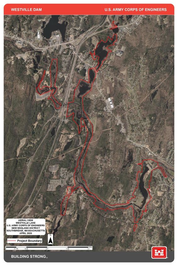
Executive Summary

This master plan covers 1,082 acres of federally owned land and real property interests
at Westville Lake. The plan prescribes a land and water management plan, and
resource objectives. The master plan provides design and management concepts which
provide the best possible combination of responses to the needs of the region,
resources capabilities, and interests and desires consistent with the projects authorized
flood control purposes. The master plan covers resources such as fish and wildlife,
vegetation, soils, cultural, interpretive, recreational and out-granted lands, easements
and water.

Inputs to the planning process included surveys and management plans for natural,
wetland and cultural resources, and an analysis of recreational use, capacity and
projected needs for project lands. Natural and man-made resources were located,
identified and analyzed, including wetlands, exemplary natural communities, and
cultural resources that require management efforts for their protection. These were
integrated into a series of project wide objectives to protect and enhance project
resources and promote and develop, as appropriate, those resources for public use,
education, and access.

Recreational opportunities were identified through an analysis of regional needs and the
public participation process. The planning process identified opportunities for the
improvement of existing recreational facilities, enhancement of boat facilities, picnic
area and play fields, and multiple resource management actions to enhance and protect
important natural and cultural resources. Enhancing and preserving the resources by
careful management of potential user conflicts were also identified.

The carrying capacity of the project is constrained by the number and size of the picnic
shelters, number of picnic tables and grills, size of the boat launches, number and size
of restrooms and limitations on the availability of parking. A review of the recreational
level of activity and demand did reveal the need for minimal expansion of the
recreational facilities that should be addressed by the Project Manager.

This master plan provides guidance for any future development or planning at Westville
Lake. The natural and man-made resources at the project will continue to be managed
to provide the best combination of responses to regional and ecosystem needs, project
resources and capabilities. During the implementation phase period of the master plan,
the New England District will continue to be responsible for the administration and
management of the project.

All specific proposals for recreational or other development at the project must comply
with this master plan, the flood risk management requirements of the Thames River
Basin, the National Environmental Policy Act and other federal requirements.

                                            ii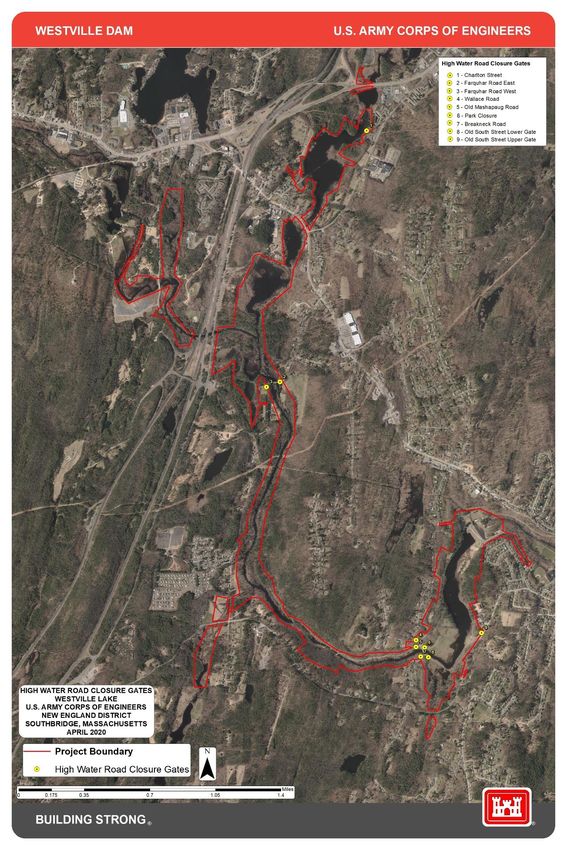
Table of Contents

PREFACE .......................................................................................................................... i

EXECUTIVE SUMMARY ................................................................................................... ii

CHAPTER 1 - INTRODUCTION ...................................................................................... 1
          1.2     Project Purpose............................................................................................ 1
          1.3     Purpose and Scope of the Master Plan ........................................................ 1
          1.4     Watershed/Project Description ..................................................................... 3
          1.5     Listing of Prior Design Memorandums ......................................................... 4

CHAPTER 2 – PROJECT SETTING AND FACTORS INFLUENCING RESOURCE
MANAGEMENT AND DEVELOPENT .............................................................................. 6
          2.2     Hydrology ..................................................................................................... 7
          2.3     Sediment and Shoreline Erosion .................................................................. 8
          2.4     Water Quality ............................................................................................... 8
          2.5     Project Access ............................................................................................. 8
          2.6     Climate ......................................................................................................... 9
          2.7     Topography, Geology and Soils ................................................................... 9
          2.8     Resource Analysis ..................................................................................... 10
                   2.8.1 Fish and Wildlife Resources ............................................................. 11
                   2.8.2 Vegetative Resources ...................................................................... 12
                   2.8.3 Rare, Threatened and Endangered Species .................................... 12
                   2.8.4 Invasive Species ............................................................................. 13
                   2.8.5 Ecological Settings ........................................................................... 13
          2.9     Cultural Resources..................................................................................... 14
                  2.9.1 Prehistoric Resources ....................................................................... 14
                  2.9.2 Historic Period ................................................................................... 15
                  2.9.3 Archaeological Resources ................................................................ 15
                  2.9.4 Prehistoric Resources ....................................................................... 15
                  2.9.5 Historic Resources ............................................................................ 16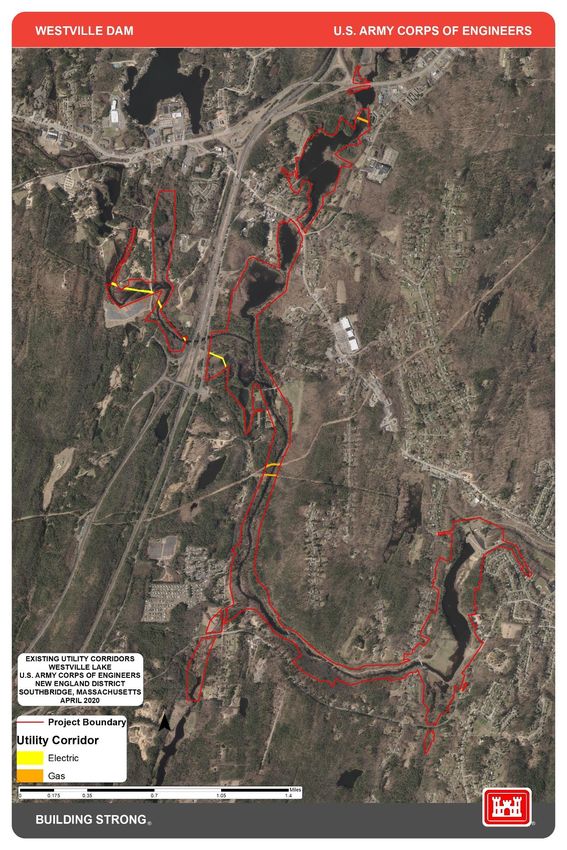
2.10 Demographics ............................................................................................. 16
               2.10.1 Population ....................................................................................... 16
                Table 2.2 – Population Projections ............................................................ 16
       2.11 Recreation Facilities, Activities and Needs ................................................. 16
               2.11.1 Westville Dam Site .......................................................................... 17
               2.11.2 Westville Lake Recreation Areas .................................................... 17
               2.11.3 Future Park Development ............................................................... 19
               2.11.4 Zones of Influence........................................................................... 19
               TABLE 2.3 Regional Recreation Facilities within 20 Miles ........................ 20
               2.11.5 Visitation ......................................................................................... 20
               TABLE 2.4 – Visitation ............................................................................... 20
               2.11.6 Recreational Analysis ...................................................................... 20
               2.11.7 Recreational Carrying Capacity ....................................................... 22
       2.12 Real Estate and Land Use Acquisition Policy.............................................. 23
       2.13 Pertinent Public Laws .................................................................................. 24
       2.14 USACE Guidance ....................................................................................... 26

CHAPTER 3 - RESOURCE OBJECTIVES .................................................................... 27
       3.1 General ......................................................................................................... 27
               3.1.1 Introduction ....................................................................................... 27
               3.1.2 Project-Wide Resource Goals ........................................................... 28
               3.1.3 General Resource Objectives ........................................................... 29
               3.1.4 Environmental Stewardship Resource Objectives .......................... 30
               3.1.5 Cultural Resource Objectives............................................................ 31
               3.1.6 Recreation Resource Objectives....................................................... 32

CHAPTER 4 – LAND ALLOCATION AND CLASSIFICATION ....................................... 33
       4.1 Land Allocation ............................................................................................. 33
               4.1.1 Operations ......................................................................................... 33
               4.1.2 Recreation ......................................................................................... 33
               4.1.3 Natural Resource Management......................................................... 33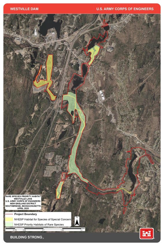
4.2 Land Classification ....................................................................................... 33
                4.2.1 Project Operations ............................................................................. 33
                4.2.2 High Density Recreation .................................................................... 33
                4.2.3 Environmentally Sensitive Areas ....................................................... 33
                4.2.4 Multiple Resource Managed Lands ................................................... 34
                TABLE 4.1 Land and Water Classification at Westville Dam ...................... 34
        4.3 Project Easement Lands................................................................................ 34
        4.4 Utility Corridors .............................................................................................. 35

CHAPTER 5 – RESOURCE PLAN................................................................................. 35
        5.1 Management by Classification ...................................................................... 35
                5.1.1 Project Operations ............................................................................ 35
                5.1.2 High Density Recreation ................................................................... 35
                5.1.3 Environmentally Sensitive Areas....................................................... 35
                5.1.4 Multiple Resource Management Lands ............................................. 35
        5.2 Development Needs ...................................................................................... 36

CHAPTER 6 – SPECIAL TOPICS/ISSUES/CONSIDERATIONS .................................. 37
        6.1 Recreation ..................................................................................................... 37
        6.2 Partnerships and Coordination ...................................................................... 37
        6.3 Encroachments and Trespasses ................................................................... 37

CHAPTER 7 – PUBLIC AND AGENCY COORDINATION ............................................. 38

CHAPTER 8 – SUMMARY OF RECOMMENDATIONS ................................................. 38

CHAPTER 9 - BIBLIOGRAPHY/REFERENCES ............................................................ 39

APPENDIX A – PROJECT TABLES .............................................................................. 42
APPENDIX B – NATURAL RESOURCE MAPS ............................................................. 48
APPENDIX C – PARK AND RECREATIONAL MAPS ................................................... 54
APPENDIX D – PROJECT MAPS .................................................................................. 57
APPENDIX E – PUBLIC COMMENTS ........................................................................... 66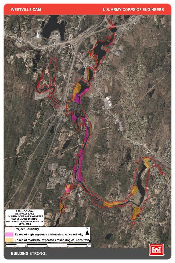
CHAPTER 1 - INTRODUCTION

1.1 Project Authorization

The Westville Lake flood risk management project was authorized by the Flood Control
Act of June 22, 1936 (Public Law 738, 74th Congress) as amended by the Flood Control
Act of June 28, 1938 (Public Law 761, 75th Congress) and constructed by the U.S. Army
Corps of Engineers (USACE) in 1962 as one unit of a comprehensive plan for flood control
in the Thames River Basin.

1.2 Project Purpose

The Westville Lake project in the Thames River Basin provides flood risk management
primarily to Southbridge, Massachusetts, and helps protect communities in conjunction
with the other projects in the basin to provide protection to the major industrial, residential
and community centers further downstream on the Quinebaug and Thames River.

Construction of Westville Dam began in April 1960 and was completed in August 1962 at a
cost of $5,684,683. Through February 2020, the facility has prevented approximately
$54,608,000 in flood damages.

In addition to flood control, the project lands also provide opportunity for public recreation,
fish and wildlife and vegetation management, and open space preservation.

1.3 Purpose and Scope of the Master Plan

By definition, master plans for USACE reservoirs are land and recreational use
management plans that do not address the technical aspects of water management for
flood risk management, navigation, or water supply. This master plan presents an
inventory of land resources, land classifications for management, modernization of existing
park facilities, an analysis of resource use, anticipated influences on project operation and
management, and an evaluation of existing and future needs required to provide a
balanced management plan to improve outdoor recreation opportunities and sustain
natural resources.

The master plan provides direction for project development and use as well as guidance
for appropriate uses, development, enhancement, protection, and conservation of the
natural, cultural, and man-made resources at the Westville Lake project. It is a vital tool for
the responsible stewardship of project resources for the benefit of present and future
generations. A master plan is programmatic and identifies conceptual types and levels of
activities, not designs, project sites, or estimated costs. All actions by USACE, the
agencies and individuals granted leases to the USACE lands (out-grantees) must be
consistent with the master plan. Therefore, it must be kept current in order to provide
effective guidance in the USACE decision-making.

Westville Lake                                                                           Page 1
Master Plan                                                                         March 2021
The master plan is based on responses to regional and local needs, resource capabilities
and suitability and expressed public interests consistent with authorized project purposes
and pertinent legislation and regulations. It provides a District-level policy consistent with
national objectives and state and regional goals and programs. The plan is distinct from
the project-level implementation emphasis of the Operational Management Plan (OMP).
Policies in the master plan are guidelines implemented through provisions of the OMP,
specific Design Memorandums and the Annual Management Plans. This master plan
supersedes the previous Westville Lake Master Plans.

This document presents data on existing conditions, anticipated recreational use, types of
facilities needed to service the anticipated use, and an estimate of future requirements.
In accordance with Engineering Regulation (ER) 1130-2-550, Change 07, dated Jan. 30,
2013 and Engineering Pamphlet (EP) 1130-2-550 Change 05, dated Jan. 30, 2013,
master plans are required for most USACE water resources development projects having
a federally owned land base. This revision of the Westville Lake Master Plan is intended to
bring the plan up to date to reflect changes in outdoor recreation trends as well as
ecological and socio-demographic changes that are currently impacting the lake and those
anticipated to occur within the planning period of 2020-2045, a 25-year period. The revised
plan focuses on overall goals and objectives and not on details of design, routine
management, and administration.

This master plan provides a comprehensive and coordinated guide for the conservation,
enhancement, development, management and use of recreation resources of the lands
and waters owned by the United States government at Westville Lake. These recreation
development plans are intended to maximize public use of project resources, within the
constraints of land suitability, recreation demand and flood control operations of the
project.

This master plan for the management of natural resources and outdoor recreation has
been prepared in accordance with the objectives and policies governing the planning,
development, and management of these resources at U.S. Army Corps of Engineers water
resources projects. These objectives and policies are outlined in ER 1130-2-540,
"Environmental Stewardship Operation and Maintenance Policies"; ER 1130-2-550,
"Recreation Operations and Maintenance Policies"; EP 1130-2-550, "Recreation
Operations and Maintenance Guidance and Procedures"; ER 1165-2-400, "Recreational
Planning, Development, and Management Policies"; and other related or referenced
regulations and policies.

ER 1130-2-540 established the following program objectives for management of a
project's natural resources.

       •   Manage natural resources on USACE administered land and water in
           accordance with ecosystem management principles to insure their continued
           availability.

       •   Provide a safe and healthy environment for project visitors.
Westville Lake                                                                          Page 2
Master Plan                                                                         March 2021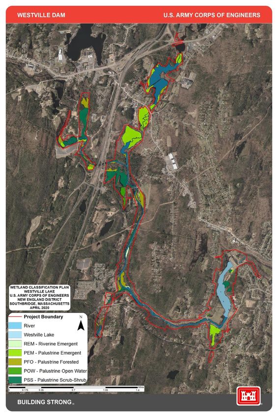
Utilizing this general guidance, ER 1130-2-550 and EP 1130-2-550 provide the specific
policy for preparation of project master plans. Each master plan must cover all resources,
including, but not limited to fish and wildlife, vegetation, cultural, aesthetic, interpretive,
recreational, mineral, and commercial and out granted lands, easements, and water.
Based on EP 1130-2-550, the primary goals of the Westville Lake Master Plan are to
prepare a concept document that prescribes an overall land and water management plan,
and establishes resource objectives, and associated design and management concepts,
which:
• Provide the best combination of responses to regional needs, resource capabilities
and suitability, and expressed public desires consistent with authorized project
purposes;
• Contribute towards providing a high degree of recreational diversity within the
region;
• Emphasize the particular qualities, characteristics and potentials of the project;
• Exhibit consistency and compatibility with national objectives and other state and
regional goals and programs.
ER 1130-2-550 further defines these goals as they relate to recreation management and
established the following program objectives:
• Provide a quality outdoor recreation experience which includes an accessible, safe
and healthy environment for a diverse population;
• Increase the level of self-sufficiency for the USACE recreation program;
• Provide outdoor recreation opportunities on USACE administered land and water
on a sustained basis;
• Optimize the use of leveraged resources to maintain and provide quality public
experiences at USACE water resources projects.
1.4 Watershed/Project Description
Westville Dam and Reservoir is located in south-central Massachusetts on the Quinebaug
River, approximately 1.3 miles west of the center of the town of Southbridge. The dam site
is south of U.S. Route 20, and approximately one mile upstream from the Massachusetts
Route 131 Bridge crossing the Quinebaug River in Sturbridge, Massachusetts. The dam
and reservoir occupy portions of Southbridge and Sturbridge, Massachusetts and are
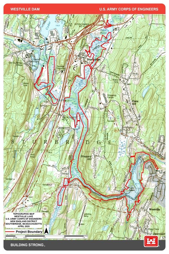
about 18 miles southwest of Worcester and 25 miles east of Springfield. Refer to Locus
Plan in Appendix D – Project Maps.
Westville Lake Page 3
Master Plan March 2021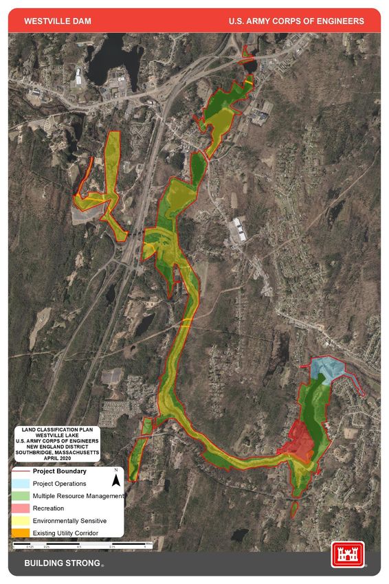
The main office for Westville Lake is located at 200 Marjorie Lane in Southbridge,
Massachusetts.

1.5 Listing of Prior Design Memorandums

Separate Design Memorandums were prepared from 1959 through 1963 setting forth
design criteria for all aspects of the project including the prime flood risk management
facilities, real estate acquisition, road and utility relocations, reservoir clearing, and the
master plan for recreation development and land management.

1.6 Listing of Pertinent Project Information

Westville Dam is a rolled-earth fill structure with rock fill slope protection and downstream
toe. The dam is 560 feet long with a maximum height of 72 feet above the riverbed. The
top of the dam, which is 25 feet wide at elevation 587.0 mean sea level (MSL)
accommodates a paved road. It has an overflow concrete ogee section spillway founded
on rock, 200 feet long with crest elevation 572.0 MSL.

The outlet works, located in a central spillway section, consists of three 4’-0” x 6’-0” gated
rectangular conduits. Three electrically operated slide gates control flow through the outlet
works. The approach channel, excavated in earth and rock, has a 30-foot bottom width.
The conduit empties out as the main channel of the Quinebaug River. Downstream
channel capacity of the Quinebaug River is 1,600 cubic feet per second (cfs).

Westville Lake                                                                             Page 4
Master Plan                                                                           March 2021
Table 1.1 – Pertinent Project Statistics

        WESTVILLE DAM

       DRAINAGE AREA: 99.5 square miles (Gross) 32.0 square miles (Net)

       FLOOD CONTROL STORAGE
       Capacity: 11,000 acre feet
       6.4 (net) inches of runoff
       Area at Crest: 913 acres

       PERMANENT POOL: 23 acre recreation pool; Stage: 10.5 feet; 525.5 feet
       National Geodetic Vertical Datum (NGVD)

       DAM
          Type: Rolled Earth Fill
          Length: 560 feet
          Top Elevation: 587 feet NGVD (72 feet)

       CONTROL WORKS
          Type: 3 Rectangular Conduits
          Size: 4' x 6'
          Length: 63 feet
          Invert Elevation: 515 feet NGVD
          Weir Elevation (top of logs): 10.5 feet (525.5 feet NGVD)
          Capacity (Full Pool): 3,750 cfs
          Gates (Type): Electric Controlled Slide
          Number: 3
          Size: 4' X 6'
          Channel Capacity: 1,600 cfs

       SPILLWAY
           Type: Chute Spillway w/Concrete Ogee Weir
           Length: 200 feet
           Elevation: 572 feet NGVD (57 feet)

       TOTAL COST: $5,684,683

       PLACED IN OPERATION: 1962

Westville Lake                                                                 Page 5
Master Plan                                                               March 2021
CHAPTER 2 – PROJECT SETTING AND FACTORS INFLUENCING RESOURCE
MANAGEMENT AND DEVELOPENT
2.1 Description of Reservoir
2.1.1 Reservoir Management General
A permanent conservation pool at elevation of 525 feet MSL (10-foot stage) creates a lake
covering approximately 23 acres with a maximum depth of 16 feet and a mean depth of 4
feet. This pool level is maintained by means of a weir in front of the middle gate. The weir
elevation is set at 525 feet MSL with a stop log provision to raise the elevation to 527 feet
MSL.
The capacity of the reservoir at spillway crest elevation is 11,100 acre-feet which is
equivalent to 6.5 inches of storage from the net drainage area of 32 square miles above
Westville Dam. When filled to capacity, the reservoir extends about 5 miles upstream to
the village of Fiskdale. The reservoir at spillway crest elevation will inundate an area of
913 acres to a maximum depth of 63 feet.
Westville Dam operates in series with East Brimfield Dam to protect the primary damage
center of Southbridge, Massachusetts. It is also operated in conjunction with Buffumville
Dam on the Little River, Hodges Village Dam on the French River and West Thompson
Dam on the Quinebaug River, for the protection of the major damage center of Putnam,
Connecticut and other downstream communities.
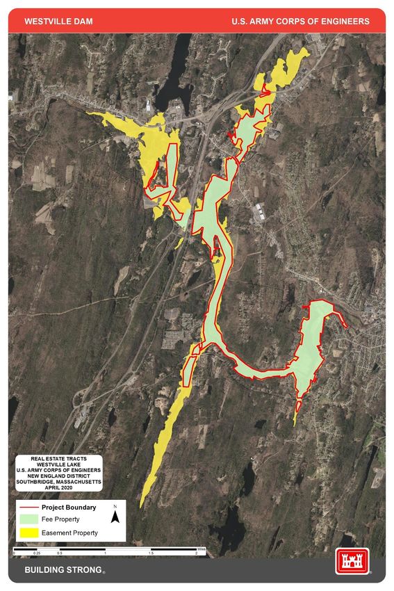
The Westville project area contains approximately 1,081 acres. Of that, approximately 578
acres are held in fee. The remaining 503 acres are held under flowage easement.
2.1.2 Operation and Maintenance
Operation and maintenance of Westville Lake is performed in accordance with the projects
Operational Management Plan (OMP) and the Operation Maintenance (O&M) Manual.
Some of the duties included are monitoring, inspections, maintenance, testing, reporting
and record keeping. These duties make possible the operation and maintenance for the
dam, appurtenant structures, buildings, bridges, utilities, roads, electrical and mechanical
equipment and tools. Specific plans for related programs are contained in sections of the
OMP and include safety, security, visitor assistance, and other activities.
In addition to inspections and reports required by the OMP and O&M Manual, periodic
inspections are performed by a team of specialists from the Engineering Division of the
New England District, U.S. Army Corps of Engineers every five years.
USACE personnel consists of three Park Rangers and a Project Manager located at East
Brimfield Lake who are responsible for operation, maintenance, and management
activities. This staff is also responsible for operation of East Brimfield Dam and Conant
Westville Lake Page 6
Master Plan March 2021Brook Dam. Temporary seasonal rangers assist in operations throughout the year. 2.2 Hydrology Regulation of Westville Lake is performed and directed by the Reservoir Regulation Section at the New England District Regional Headquarters in Concord, Massachusetts. The Reservoir Regulation Section is the “command center” for all USACE-operated dams in New England. They consistently monitor river levels and weather conditions and direct the operation of the dams during high flows. There are emergency operating procedures available in the event that the park manager is unable to communicate with the Reservoir Regulation Section by normal or emergency methods. Westville Lake has an Emergency Action Plan (EAP) updated and in place for such emergencies. Reservoir pool stage levels, tail water levels, and accumulated rainfall measurements are collected locally at the dams using Sutron data collection stations. At the dam there is a United States Geological Survey (USGS) gauging station that is located a short distance downstream to provide continuous records of releases from the project. This data is stored and transmitted to the reservoir regulation team to assist in the regulation of project outflows. Flood waters are discharged by operating the outlet gates at Westville Lake and releases are coordinated with those from other reservoirs in the Thames River Basin. The release rates from the reservoir are dependent upon river conditions at the downstream damage centers, but in no case would they exceed the safe channel capacities of the Quinebaug River. Reservoir regulation is normally conducted in three phases: phase I involves the initial appraisal of storm and river conditions that leads to regulation of flows; phase II concerns regulation during the event as flood flows crest and move downstream; and phase III includes emptying of the reservoir following recession of flood level flows. Guidance for the control of flow from Westville Lake is summarized in Appendix A, Table 1 – Outflow Guidance for Westville Dam. On Aug. 1, 2008, restricted regulation procedures were implemented that restricted the reservoir pool level from rising above twenty feet. This action was taken to minimize the risks associated with seepage concerns at Westville Dam until the condition was rectified. This restriction has since been rescinded. Reservoir area capacity/frequency information and historic reservoir flood water storages are summarized in Appendix A, Table 2 – Area Capacity of Westville Lake and Appendix A, Table 3 – Annual Peak Pool Levels. 2.3 Sediment and Shoreline Erosion The general elevation range in the vicinity of the reservoir ranges from about 510 MSL in the stream bed at the dam site to about 810 MSL The general vicinity of the reservoir is Westville Lake Page 7 Master Plan March 2021
marked by an extended series of ridges and hills cut by the serpentine course of the
Quinebaug River and the many small streams flowing into it. There are portions of the
watershed that are fairly steep and conducive to runoff.

All recreational areas experience erosion problems to varying degrees. Erosion control
efforts have been implemented as needed to protect the recreation facilities, sensitive
habitats, or other resources by a combination of efforts such as implementing Best
Management Practices (BMPs), and other vegetation plantings and structural solutions.

2.4 Water Quality

During normal flow periods, the Westville Dam impounds a 23-acre conservation pool with
a maximum depth of 16 feet and a mean depth of 4 feet.

The Massachusetts Department of Environmental Protection has designated the waters at
Westville Lake as class B, indicating they should be suitable for swimming and fishing,
among other purposes. Water quality is good in that it generally meets state standards and
is usable for intended purposes including recreation, aquatic habitat and aesthetics. One
significant problem is mercury contamination of fish; there is a statewide advisory
recommending limits on the consumption of freshwater fish caught in Massachusetts:
children under age 12 and pregnant and nursing mothers should refrain from eating all
species, and the general public should limit consumption to no more than two meals per
month.

Baseline Monitoring
Data and observations show the water quality is generally good and supports most of its
intended uses. Mercury contamination of the fish is a concern throughout New England.
Water temperatures indicate the project supports a good warm water fishery in the lake.

Beach Monitoring
There are neither formal nor informal beach areas at Westville Lake, so no beach
monitoring is performed.

Potable Water Monitoring
Westville Lake has town supplied potable water and no USACE water monitoring is
performed.

2.5 Project Access

Main access to the project area is provided via Interstates 90 and 84 and Massachusetts
Route 131. The entrance to Westville Dam and the administrative area is located on
Marjorie Lane, off of South Street in Southbridge, Massachusetts. The park entrance is
located on Wallace Road, off of Route 131 in Sturbridge, Massachusetts.

Westville Lake                                                                     Page 8
Master Plan                                                                    March 2021
2.6 Climate

The Thames River Basin has a variable climate characterized by frequent but generally
short periods of heavy rainfall in the summer and longer periods of less intense
precipitation in the winter. The basin climate is influenced by the prevailing westerly wind
and the cyclonic storms that move across the country from the west or southwest. The
area is also exposed to costal storms, locally known as "Northeasters” that travel up the
Atlantic seaboard. Tropical hurricanes occur less frequently but have historically caused
severe flooding in the Thames River Basin and its tributaries, most notably in August 1955
(Hurricanes Connie and Diane).

The mean annual precipitation over the Thames basin is about 44 inches which is
distributed rather uniformly throughout the year. High water events can be expected in any
season, resulting from early spring rains combined with melting snow, or heavy rains
during the summer and fall. About one-third of the precipitation during the winter months is
in the form of snow. Annual snowfall averages from 36 to 40 inches in the southern portion
near the coast to about 60 inches at northerly inland points.

The average annual temperature of the basin is 49 F. Average monthly temperatures
range between 15-33 F in January and 59-81 F in July. The frost-free season is
approximately 135 days in length, varying somewhat with location in the basin.

2.7 Topography, Geology and Soils
       2.7.1 Topography
The topography of the reservoir area is hilly with moderate relief. Much of the reservoir lies
in the steep, narrow valley of the Quinebaug River while upstream the valley is broader,
containing areas of seasonally flooded wetlands. Four tributary streams enter the reservoir
area: Hamant Brook, Hobbs Brook, Breakneck Brook and Hatchet Brook. Hamant Brook
empties into the river from the south west of Interstate 84. Hobbs Brook approaches from
the north-east and joins the river between Farquhar Road and Interstate 84. Breakneck
Brook approaches from the south-southwest and joins the river at the intersection of River
Road and South Street. Hatchet Brook flows from the south-southeast and joins the river
at Old South Street. Elevations range from 515 feet NGVD in the stream bed at the dam to
810 feet NGVD on top of Shepard Hill overlooking the reservoir. Refer to Topography Map
in Appendix D – Project Maps.

       2.7.2 Geology
The project area, which is situated in Worcester County, was subject to glaciation during
the Ice Age or Pleistocene Epoch beginning about one million years ago. Glaciation
rounded and smoothed the bedrock, hills and ridges of the area, and covered them with a
thin layer of till. The principle evidence of the Late Wisconsin glacial period is stratified and
unstratified drift. Post-glacial deposits in the project area arrear to be similar to those found
in other upland sections of the Worcester Plateau. Steeply sloping upland hillsides in and
near the area are covered with deposits of stony glacial till, ground moraine, outwash
plains, and kame terraces. Broad glacial terrace and outwash deposits make up the valley
Westville Lake                                                                            Page 9
Master Plan                                                                          March 2021
floor along much of the Quinebaug River.
2.7.3 Soils
A variety of soils types have been identified in the project area. The following soils
predominate at the project:
• Freetown muck. This soil is very deep, poorly drained, and nearly level.
• Decomposed organic material many feet deep lies on top of sandy or loamy material.
The water table is at or near the surface most of the year. Permeability is moderate
or moderately rapid. Marsh vegetation is common including cattails and rushes.
• Merrimac fine sandy loam, 3%-8% slopes. This soil is deep and somewhat
excessively drained on glacial outwash plains, terraces and kames. Permeability is
moderately rapid over loose stratified sand and gravel substrata.
• Paxton fine sandy loam, 8%-15% slopes. This soil is deep and well drained on
drumlins. It is formed in compact glacial till. Permeability is moderate in the surface
and subsoil but very slow in the very firm substratum (hardpan). This soil is very
stony or extremely stony.
• Paxton fine sandy loam, 15%-35% slopes. Description is the same as above.
• Udorthents, smoothed. This soil has been disturbed by construction operations.
The natural soil layers no longer exist and are no longer a factor in determining land
limitations.
The following soils are also found within the project boundaries but to a lesser extent:
Chatfield-Hollis-Rock Outcrop Complex, Hinckley sandy loam, Saco very fine sandy loam,
Scituate fine sandy loam, Walpole and Scarboro fine sandy loam.
2.8 Resource Analysis
The environmental resources of the Westville Lake project provide important and valuable
natural resource and recreational opportunities. The project maintains a wide variety of
fish and wildlife resources and provides popular recreational facilities for the surrounding
areas. Fish and wildlife management are carried out on project lands. Recreational
activities include picnicking, boating, fishing and hiking.
The project area consists of a total of 578 acres owned in fee and 503 acres held in
flowage easement. All lands at the project are under the jurisdiction of the U.S. Army
Corps of Engineers. Of the 578 acres, 48% (278 acres) are forested, 37% (214 acres) are
wetlands, 9% (54 acres) is non-forested, i.e. open fields and abandoned fields and 5% (32
acres) is non-vegetated, i.e. roads and areas covered by project operation structures.
Westville Lake Page 10
Master Plan March 20212.8.1 Fish and Wildlife
Westville Lake supports a warm water fishery. Fishing pressure is low. Pan fish are
abundant. The feeder streams are generally shallow and narrow and contain primarily
warm water species. Warm water species likely to be present are:
Northern pike – Esox lucius
Largemouth bass - Micropterus salmoides
Brown bullhead - Ictalurus mebulosus
Yellow bullhead - Ictalurus natalis
Bluegill - Lepomis macrochirus
Pumpkinseed - Lepomis gibbous
White sucker - Catostomus commersoni
Yellow perch - Perca flavescens
White perch - Monroe americana
Chain pickerel - Esox niger
Black crappie – Pomoxis nigromaculatus
Golden shiner – Notemigonus crysoleucas
Creek chub – Semotilus atromaculatus
Swamp darter – Etheastoma fusiforme
Black nosed dace – Rhinichthys atratulus
Fallfish – Semotilus corporalis
Creek chub sucker – Erimyzon oblongus
The Massachusetts Division of Fisheries and Wildlife stocks the Quinebaug River along
Old Mashapaug Road within the project boundaries with rainbow and brown trout in April
and May. Water level fluctuations periodically occur due to reservoir regulations for flood
risk management purposes. These fluctuations can be both beneficial and detrimental to
fish species with the extent of the damage depending on many factors including the time of
year, the amount of fluctuation and the direction of fluctuation.
The Westville Lake property is comprised of a diversity of natural communities. This
community diversity, in part, is responsible for the great diversity of animals which are
present on the project. Beaver colonies are scattered throughout the Quinebaug River
Watershed. Deer, fox, skunk, fisher, raccoon, bobcat, coyote, turkey, muskrat and river
otter are readily found in the vicinity of the project. Migrating waterfowl such as geese and
ducks visit seasonally and are being encouraged by current wildlife management
programs. Continued habitat assessment and planning will ensure habitat diversity.
Wildlife species that may be expected to occur within the project (per Massachusetts
Fish and Wildlife) are summarized in Appendix A, Table 4 – Wildlife Species Present in
Massachusetts.
2.8.2 Vegetative Resources
Approximately 48%, or 278 acres of the 578 acres owned in fee are forested. Much of the
forested area is in second growth white pine and white pine-hardwood types. The principle
Westville Lake Page 11
Master Plan March 2021species include Eastern white pine (Pinus strobus), red oak (Quercus rubra), white oak
(Quercus alba), Eastern Hemlock (Tsuga canadensis), red maple (Acer rubrum) and
quaking aspen (Populus tremuloides).
The forest cover is in the 60 - 90 year age class and most stands are even aged. The
crown closure averages 100% in pole and saw log size stands. Due to the large amount of
competing undesirable growing stock and cull trees, acceptable growing stock is low to
moderate. The overall quality of the forestry growing stock is fair to medium. Forest cover
types are delineated on Forest Classification Plan in Appendix A – Natural Resource
Maps.
2.8.3 Rare, Threatened and Endangered Species
In 1997, the Massachusetts Natural Heritage and Endangered Species Program (NHESP)
contracted with USACE to identify and locate rare or protected species, critical habitat for
rare or protected species, and any outstanding natural communities occurring at Westville
Lake. Taxonomic experts from NHESP staff or contractors carried out the inventory.
No species of federally threatened or endangered status were located on the property.
Four state listed rare species of special concern and one listed as threatened were found
at Westville Lake during the survey. A wood turtle (Glypternys insculpta) was found near
Farquhar Road. The triangle floater mussel (Alasmidonta undulata) and squawfoot mussel
(Strophitus undulatus) were located in the Quinebaug River near Old Sturbridge Village.
The Hessel’s hairstreak butterfly (Mitoura hesseli) was found in the Atlantic white cedar
vernal pool.
Two watch list plants were found at the downstream toe of the dam: whorled milkwort
(Polygala verticillata) and the fringed gentian (Gentianopsis crinita).
With the decline in regional bat populations, the northern long-eared bat (Myotis
septentrionalis) has been federally listed as a threatened species under the Endangered
Species Act and included on our list of potential species at the project.
Priority habitat is the mapped geographical extent of known habitat for all state-listed rare
plants and animals. These areas are shown on the Rare Species Priority Habitat Map in
Appendix B – Natural Resource Maps.
2.8.4 Invasive Species
Executive Order 13112 (Invasive Species, Feb. 3, 1999), directs USACE and other federal
agencies to prevent the introduction of invasive species and provide for their control and to
minimize the economic, ecological, and human health impacts that invasive species
cause. Additional guidance include, “Memorandum, HQUSACE, CECW-ZA, 2 JUN 2009,
Subject; US Army Corps of Engineers Invasive Species Policy” and “Memorandum,
Westville Lake Page 12
Master Plan March 2021HQUSACE, CECW-CO, 17 DEC 2009, Subject; Guidance on authorities for project
Specific Restoration to Manage the Introduction of Invasive Species.” Westville Lake will
adapt management goals, practices and policies used by the National Invasive Species
Council (NISC) 2008-2012 National Invasive Species Management Plan and adopt a long-
term management plan. The strategic goals include prevention, early detection and rapid
response, control and management, restoration, and organizational collaboration.
Dr. Robert Bertin conducted a survey of the vascular plants at Westville Lake in 1997 as
part of the Rare Species Survey conducted by the Natural Heritage and Endangered
Species Program. In general, past uses of certain parts of the property for residential,
industrial and agricultural purposes have resulted in the introduction of a variety of non-
native species. These disturbed areas were quite favorable for the establishment of
introduced species. Of the alien species identified, the following are the most notable:
• Asian bittersweet – Celastrus orbiculata: southwest end of Old Charlton Street
• Coontail – Ceratophyllum demersum: Hobbs Brook
• Morrow’s honeysuckle – Lonicera morrowii: common at several sites
• Purple loosestrife – Lythrum salicaria: along water margins and marshes
• Phragmites – Phragmites australis: Cedar swamp and parts of the Hobbs Brook
marshes
• Japanese knotweed – Polygonum cuspidatum: at the recreation area
• European buckthorn- Rhamnus frangula: in the recreation area and west of the river
above the dam
• Multiflora rose - Rosa multiflora: numerous locations
2.8.5 Ecological Settings
The Westville Lake project is situated on hilly land with moderate relief in south-central
Massachusetts, with an elevation range of 515 feet NGVD in the stream bed at the dam to
810 feet NGVD on top of Shepard Hill overlooking the reservoir. The general vicinity of the
reservoir is marked by an extended series of ridges and hills cut by the serpentine course
of the Quinebaug River and the many small streams flowing into it. Even along the bank of
the river there is little flat land and the frequency of sharp slopes and precipitous
riverbanks has resulted in narrow winding secondary roads serving much of the area.
Much of the forested area is in second growth white pine and white pine-hardwood types.
The Quinebaug River flows through the area in a generally easterly direction. The average
slope of the river in the vicinity of the dam site is about 10 feet to the mile.
2.8.6 Wetlands
The U.S. Army Corps of Engineers, New England District, conducted a wetlands
delineation of the Westville Lake in 1997. The study was updated in 2007 using 2005
orthophotography from the Massachusetts geographic information system (GIS). The aim
of the study was to identify and characterize the surface waters and wetland communities
Westville Lake Page 13
Master Plan March 2021on the project site. Roughly 40% of the project area (229 acres) is comprised of wetlands.
A summary of the wetland types occurring at the project is included in Table 2.1 below.
Table 2.1 – Wetland Descriptions
Wetland Description Acres
Palustrine Open Water 4
Palustrine Emergent Vegetation 52
Palustrine Scrub Shrub Vegetation 40
Palustrine Forested Open Vegetation 22
Riverine Emergent 2
Riverine Open Water 94
TOTAL 214
Intermittent Streams 2.6 linear miles
Wetland mapping for the project is shown on the Wetland Classification Plan in Appendix
B – Natural Resource Maps.
2.9 Cultural Resources
2.9.1 Prehistoric Period
Prehistoric settlement and land use patterns are characterized by limited use of upland
areas and more intensive use of terraces above navigable streams and rivers for hunting,
fishing and foraging. The project area includes both riverine and tributary stream/wetland
environmental settings that contain high resource potential. Certain sections of the
Westville Lake project have physical attributes that appear very similar to the locations of
previously recorded prehistoric sites in the interior uplands of Massachusetts.
One of the primary features of the project area is the predominance of narrow terrace
zones bordering open water or wetlands. These terraces represent the kind of physical
setting where prehistoric sites are often distributed.
2.9.2 Historic Period
Prior to the acquisition and construction of the project in 1960, the reservoir area was in a
rural setting consisting of houses, agricultural fields and buildings, and wooded hillsides of
predominately mixed hardwoods with white pine. Potential waterpower sites are
numerous. Based on an examination of historic maps, several sites classified as domestic,
agrarian, industrial and transportation were known to have been located on the property. In
general, historic archaeology in New England has centered on individual sites and
structures dating back to the Colonial period (17th and 18th centuries).
Westville Lake Page 14
Master Plan March 20212.9.3 Archaeological Resources
In 1987, a Cultural Resource Reconnaissance Survey was conducted by the Public
Archaeology Laboratory, Inc. (PAL) under contract to IEP Inc. and the U.S. Army Corps of
Engineers. This study included background research to review data on known cultural
resources and formulation of a sensitivity ranking for the project area. Field testing of the
sensitivity map for prehistoric resources by limited subsurface testing was performed. A
project walkover inspection identified historic cultural resources from documented sources.
Two sites were identified as possessing prehistoric archaeological sensitivity and 35
historic sites were located. Nine high-sensitivity and 11 medium-sensitivity areas were
delineated by the 1988 PAL survey.
An Intensive (Locational) Archaeological Survey of Westville Lake was conducted in 2011
by Hardlines Design Co. which concentrated on the nine high-sensitivity areas delineated
by PAL in 1988. The following information is based upon the results of the reconnaissance
survey and the subsequent more detailed survey of the upper end of the reservoir
conducted in 2011 by Hardlines Design Co.
The stratified zones of high or medium archaeological sensitivity require further
investigation. Areas of high and moderate archaeological sensitivity are depicted in the
Archaeological Sensitivity Map in Appendix B – Natural Resource Maps. Please note that
archaeological site locations are confidential information that is exempt from the Freedom
of Information Act requirements and cannot be divulged to the general public.
An accurate evaluation of the potential significance of the two known prehistoric sites
cannot be made with the limited information now available. More intensive archaeological
investigation would be necessary to assess their potential eligibility for listing on the
National Register of Historic Places. Most identified areas of high and moderate
archaeological sensitivity are located in areas that are used primarily for passive
recreational pursuits such as fishing, hiking, and bird watching.
2.9.4 Pre-Historic Resources
The original reconnaissance survey (PAL 1987) identified and documented two pre-
contact period (12,500-3,000 Years Before Present) sites within the project boundary. An
additional PAL survey in 1999 identified and documented nine newly discovered pre-
contact period sites within the project boundary. Hardlines Design Co. (2011) identified 15
new pre-contact sites.
2.9.5 Historic Resources
The original reconnaissance survey (PAL 1987) documented 35 post-contact period (1620
A.D.- present) sites. An additional PAL survey in 1999 identified and documented six
newly discovered pre-contact period sites within the project boundary. The results of the
Intensive Survey by Hardlines Design Co. (2011) identified 17 new post-contact period
sites. In contrast to the reconnaissance survey performed in 1987 by PAL, the post-
contact sites identified represent refuse disposal activities associated with domestic sites,
Westville Lake Page 15
Master Plan March 2021rather than the mix of industrial and infrastructure-type sites identified in 1987. In addition,
the survey results significantly reduce the size of the areas identified as having a high
sensitivity for archaeological resources.
2.10 Demographics
2.10.1 Population
Table 2.2 – Population Projections
TOWN Pop. 2020 Pop. 2025 est. Pop. 2030 est. Pop. 2035 est.
BRIMFIELD 4,402 3,813 3,786 3,704
BROOKFIELD 3,796 3,766 3,842 3,860
CHARLTON 16,582 15,741 16,771 17,720
DUDLEY 10,824 13,029 13,417 13,810
E. BROOKFIELD 2,070 2,258 2,241 2,208
HOLLAND 3,223 2,454 2,405 2,326
OXFORD 13,818 13,328 12,902 12,411
SOUTHBRIDGE 17,669 16,328 16,037 15,721
SPENCER 11,897 11,071 10,608 10,034
STURBRIDGE 8,847 10,845 11,332 11,738
WALES 2,288 1,859 1,841 1,812
WARREN 5,64O 5,635 5,741 5,808
WEBSTER 18,306 17,206 17,178 17,022
TOTAL: 113,722 117,333 118,101 118,174
SOURCE: UMASS Donahue Institute of Economic & Public Research
2.11 Recreational Facilities, Activities and Needs
The following is an overview of the facilities located at Westville Lake. Recreation facilities
are centered on the developed recreation area and around the administration area. A
general description of the recreational activities and facilities that are presently offered for
public use are described below and as noted on the Recreation Site Plan in Appendix C –
Park and Recreation Maps.
2.11.1 Westville Dam Site
The flood risk management facility at Westville Lake is operated and maintained by the
U.S. Army Corps of Engineers. The specific facilities include the dam structure and control
tower, the intake and outlet channels, the spillway and related structures required for the
operation of the dam. USACE offers tours of the Westville Dam facility, by appointment, to
Westville Lake Page 16
Master Plan March 2021learn about the operation of this flood risk management facility. A paved, striped parking
lot for seven vehicles is located at the end of the dam access road and serves as a scenic
overlook of the dam and reservoir area. Two park host sites are located adjacent to the
project office.
2.11.2 Westville Lake Recreation Areas
The recreation area at Westville Lake consists of approximately 31 acres of which 25
acres are developed. The remainder is forested trail areas. The park is open 8 a.m. to 8
p.m. from the second Saturday in May through the second Sunday in September. A
volunteer park host campsite is located on the access road to the park. No swimming area
is provided at the project.
2.11.2.1 Trails
The Westville section of the Grand Trunk Trail, a National Recreation Trail, winds along
the Quinebaug River on the bed of the defunct Grand Trunk Railroad. A gravel parking lot
outside the main gate of the recreation area provides space for 20 vehicles and serves as
the trailhead for this section of the Grand Trunk Trail. The Grand Trunk Trail extends north
on the west side of the reservoir area approximately ¾ mile to Westville Dam and to the
west approximately one mile to River Road. The trail is used by hikers on a year-round
basis, by bicyclists in summer, and cross country skiers in winter.
The Heritage Trail starts at the Southbridge West Street School and extends north
approximately one mile along the east side of the reservoir area up Old South Street to the
Grand Trunk Trail trailhead. The trail is used by hikers and joggers year-round. A bridge
across the inlet channel on the upstream side of Westville Dam connects this trail with the
Grand Trunk Trail.
Trails are delineated on the Trails Map in Appendix C – Park and Recreation Maps.
2.11.2.2 Athletic Field
A 4.5-acre field in the park may be reserved for baseball, softball and soccer activities. A
paved parking lot adjacent to the field provides parking for 32 vehicles. A drinking fountain
is located between the parking lot and the athletic field.
2.11.2.3 Boat Launch
A paved boat ramp is located within the park on the southwestern side of the recreation
pool. A paved, striped, parking lot provides parking for 13 cars and trailers. The use of
watercraft including motorboats, canoes, kayaks, rowboats, and other vessels are
permitted. All persons using watercraft are required to comply with applicable U.S. Coast
Guard, U.S. Army Corps of Engineers and Massachusetts laws and regulations. Personal
watercraft, including jet skis, are not allowed.
Westville Lake Page 17
Master Plan March 20212.11.2.4 Picnic Area
A picnic area is located at the end of the access road on the hilltop overlooking the athletic
field area. Facilities include two picnic shelters that may be reserved for a nominal fee (the
large shelter has 10 picnic tables, two group size grills and electricity and the smaller
shelter has five picnic tables, one group size grill and electricity) and a comfort station with
flush toilets (each side has one handicapped accessible toilet).
In addition, the following facilities are available in the picnic area: 40 picnic tables, 20
pedestal grills, two drinking water fountains, handicapped accessible portable toilet, public
pay telephone, and a paved, striped, parking lot which provides parking for 75 vehicles.
Approximately 13 acres of regularly mowed lawns are used for kite-flying, sunbathing,
blanket picnicking, snow sledding, games and special events.
2.11.2.5 Old Mashapaug Road
A one mile long section of Old Mashapaug Road winds along the Quinebaug River from the
recreation area entrance west to the limits of government property. A canoe launch located
at the end of the road provides access to the upper reaches of the Quinebaug River within
the reservoir area. Stream fishing is popular along the entire length of the road.
2.11.2.6 Ice Skating Pond
Near the recreation area entrance is an area that is flooded in the winter months with
approximately six inches of water for use as an ice skating pond. Benches are provided
around the edge for visitors.
2.11.2.7 Other Recreational Activities
Hunting, fishing and trapping are permitted on project lands in accordance with applicable
federal and state laws. No hunting is permitted in the Westville Lake Recreation Area or in
the immediate vicinity of the dam.
Presently, lake-staff manage recreation areas using historic visitation data combined with
best professional judgment to address recreation areas considered to be overcrowded,
overused, underused, or well balanced. Project staff will continue to identify possible
causes and effects of overcrowding and overuse and apply appropriate best management
practices including site management, regulating visitor behavior, and modifying visitor
behavior.
2.11.3 Future Park Development
The demand for recreation at Westville Lake is expected to increase over time. This is
based on existing and past use of the facility as well as the needs identified in the
Massachusetts Statewide Comprehensive Outdoor Recreation Plan (SCORP 2006). For
Westville Lake Page 18
Master Plan March 2021You can also read