What's New in Power Portfolio 2020 - Hexagon Global Brand ...
←
→
Page content transcription
If your browser does not render page correctly, please read the page content below
What’s New in Power Portfolio 2020

What’s New in Power Portfolio 2020

29 October 2019
Contents
Power Portfolio Overview ............................................................................................................. 5
Release Highlights ......................................................................................................................... 5
Producer Suite .............................................................................................................................. 5
ERDAS IMAGINE® .................................................................................................................... 5
ImageStation® ........................................................................................................................... 5
GeoMedia® ................................................................................................................................ 5
Provider Suite ............................................................................................................................... 6
Platform Suite ............................................................................................................................... 6
Producer Suite ................................................................................................................................ 7
ERDAS IMAGINE ......................................................................................................................... 7
New Platforms ........................................................................................................................... 7
Image Chain Printing ................................................................................................................ 7
Optimal Seamline Generation................................................................................................... 7
MIE4NITF .................................................................................................................................. 7
Create Image Pyramid .............................................................................................................. 7
Enhance Contrast Using CLAHE.............................................................................................. 8
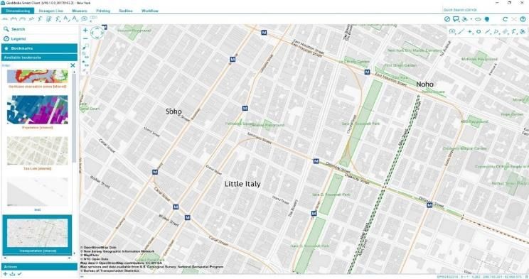
GeoMedia ..................................................................................................................................... 8
Excel Data Server ..................................................................................................................... 9
SQL Server Spatial Data Server............................................................................................... 9
Warehouse Connections Command ........................................................................................ 9
Spatial Modeling........................................................................................................................ 9
Explorer Window ....................................................................................................................... 9
Raster Band Selection ............................................................................................................ 10
Geotagged Images ................................................................................................................. 10
Drag-and-drop ......................................................................................................................... 10
ImageStation ............................................................................................................................... 10
New Platforms ......................................................................................................................... 10
Satellite Support Enhancements ............................................................................................ 10
DTM Collection Improvements ............................................................................................... 11
29 October 2019 2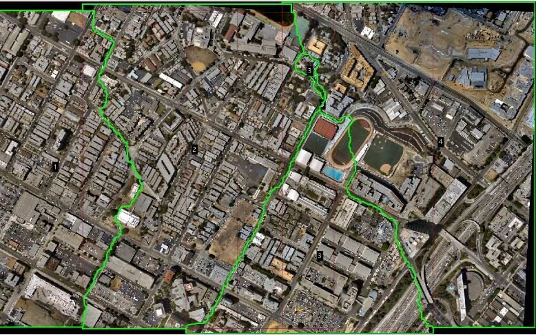
User-Defined Styles for DTM Features .................................................................................. 11
      Manual DTM Point Collection ................................................................................................. 11
      Drape Features Command ..................................................................................................... 11
      Stereo Roam Performance Improvements ............................................................................. 11
      64-bit Mosaicking .................................................................................................................... 11
      ECW Output ............................................................................................................................ 12
      Burn Features Command ....................................................................................................... 12
      3D Input Device Support......................................................................................................... 12

Provider Suite ............................................................................................................................... 12
   ERDAS APOLLO ........................................................................................................................ 12
      New Platforms ......................................................................................................................... 12
      New Catalog Client ................................................................................................................. 12
      Advanced Logging Charts ...................................................................................................... 13
      AOI Notification Service .......................................................................................................... 13
      ECWP Browser Streaming Lives Again ................................................................................. 13
   GeoCompressor ......................................................................................................................... 13
      Performance Improvements ................................................................................................... 13
      GeoCompresser Viewer.......................................................................................................... 14
   ERDAS ECW JP2 SDK .............................................................................................................. 14
      Performance Improvements ................................................................................................... 14
      New Platform ........................................................................................................................... 14

Platform Suite ............................................................................................................................... 14
   GeoMedia Smart Client .............................................................................................................. 14
      Platform Changes ................................................................................................................... 15
      4K Display Support in Workflow Manager .............................................................................. 15
      Integrated Log Console........................................................................................................... 15
   GeoMedia® WebMap .................................................................................................................. 16
      GeoMedia WebMap Mobile for Field Data Editing ................................................................. 16
      Mobile Publisher for GeoMedia WebMap Mobile Configurations .......................................... 16
      Performance Improvements ................................................................................................... 17
   Geospatial Portal ........................................................................................................................ 18

29 October 2019                                                                                                                                3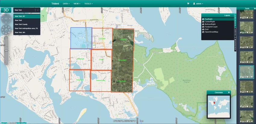
Enhanced Measurements in Geospatial Portal - Consumer ................................................. 18
      Groups for Layers in Geospatial Portal - Consumer .............................................................. 18
      Support for Custom Layer Graphics in Geospatial Portal - Consumer ................................. 18
      Information Bar in Geospatial Portal – Consumer ................................................................. 19
      Extrude Analysis Results in Geospatial Portal - Classic ........................................................ 19
      Display Extruded Data in Geospatial Portal – Consumer ...................................................... 19

Contact Us .................................................................................................................................... 20

About Hexagon ............................................................................................................................. 20

Copyright....................................................................................................................................... 21
   Product Documentation Terms of Use ....................................................................................... 21
   Use Of This Document ............................................................................................................... 21
   Disclaimers ................................................................................................................................. 21
   Limitation Of Liability .................................................................................................................. 21
   Indemnification............................................................................................................................ 21
   Use Of Software ......................................................................................................................... 22
   Links To Third Party Websites ................................................................................................... 22
   Trademarks................................................................................................................................. 22
   Procedure For Making Claims Of Copyright Infringement ........................................................ 22
   US Government Restricted Right ............................................................................................... 22
   International Use......................................................................................................................... 22
   Revisions .................................................................................................................................... 23
   Applicable Law............................................................................................................................ 23
   Questions .................................................................................................................................... 23

29 October 2019                                                                                                                                   4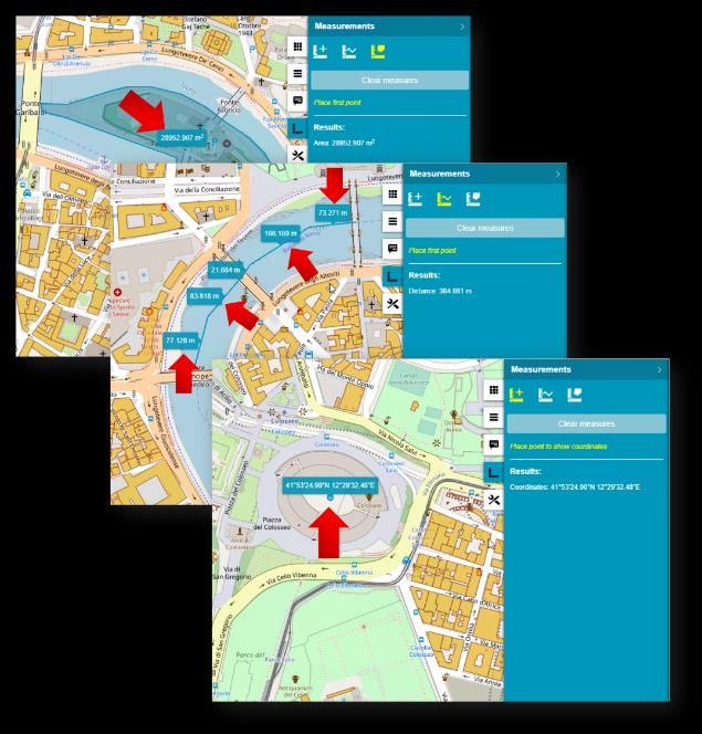
Power Portfolio Overview
Understanding change and deriving the information you require to make mission- and business-critical
decisions is imperative to you. With creative and intuitive interfaces, smart workflows, and automated
technologies, the Power Portfolio from Hexagon’s Geospatial division can transform multi-source content into
actionable information.

For simplicity, the Power Portfolio organizes our products into suites, combining the best photogrammetry,
remote sensing, GIS, and cartography technologies available. The Producer, Provider, and Platform suites
contain the globally recognized products that you rely on every day.

    •   Producer Suite – Collect, process, analyze, and understand raw geospatial data
    •   Provider Suite – Easily compress, manage, and deliver your data across desktop, web, and mobile applications
    •   Platform Suite – Create your own unique application on top of a solid foundation of powerful geospatial
        functionality

Release Highlights
Hexagon’s Geospatial division makes strides in smart situational awareness with expanded data viewing and
analysis capabilities in the Power Portfolio 2020 release. Through many new features and updates to each
product suite, we provide the necessary technology to further industries such as defense and smart cities while
aiding in the growth of dynamic information services.

Producer Suite
Access the latest data and view it from more perspectives so you can analyze situations and predict outcomes.

ERDAS IMAGINE®
    •   Full 64-bit Support - Better use of memory in all commands and applications
    •   MIE4NITF Support - Time series data sets are now being stored and delivered in NITF
    •   Pyramid Layer Generation (PYRX format) - Extended Compressed Pyramid Layers reduces the file size of
        images up to 10 times
    •   Contrast Limited Adaptive Histogram Equalization (CLAHE) compresses high dynamic range images while
        preserving and enhancing detail

ImageStation®
    •   Automatic tie point matching and new bundle adjustment with options to withhold, reinstate, and delete point
        measurements for satellite projects has been added to ImageStation Automatic Triangulation
    •   General stereo roam performance and stereo roam performance when placing linear features has been improved
    •   Classification of auto-generated points is now saved in DTM format files and used for display and editing in
        ImageStation Stereo for GeoMedia and ImageStation DTM for GeoMedia
    •   New commands for operator-assisted manual DTM collection in ImageStation Stereo for GeoMedia - Generate
        Uncollected Points and Collect Points
    •   Mosaic process has been upgraded to 64-bit with processing speeds up to 14 times faster, and ECW output
        option in ImageStation OrthoPro

GeoMedia®
    •   A new Microsoft® Excel® data server permits direct use of Excel and CSV files
    •   New operators have been introduced for performing geometry manipulations on feature data, and
        watershed analysis on grid data
    •   Drag-and-drop capability for dragging raster and warehouse files into the GeoWorkspace as attached data
    •   Raster band selection for imagery
    •   Placement and review of geotagged photos

29 October 2019                                                                                                        5
Provider Suite
Find and deliver the right data, at the right time, to securely share information and make informed decisions.

    •   New Catalog Client added – vastly improves the user experience discovering data holdings from ERDAS
        APOLLO®
    •   New WebAssembly ECWP Browser decoder - stream terapixel sized images from and to any device
    •   Code modernization to C++ 11 base standard in ECWJP2 SDK - yielding performance gains and ensuring we can
        continue to support the numerous platforms our customers demand across desktop, server, and mobile.
    •   Changes to GeoCompressor’s user interface and included utilities - delivering incremental performance
        improvements up to 25%

Platform Suite
Take advantage of dynamic information services in customized workflows that let your users make smart,
mobile decisions no matter their location.

    •   Improved user experience – with GeoMedia® Smart Client’s new integrated log console, 4K display support in
        workflow manager, and OpenJDK as the new standard virtual machine
    •   Mobile MapWorks has been integrated into GeoMedia WebMap with improved workflows, updated interface, and
        feature enhancements
    •   Enhanced Measurements and Customized layer graphics in Geospatial Portal - Consumer
    •   Enhanced Printing for High DPI images in Geospatial Portal - Classic
    •   Apply extrusions in Geospatial Portal - Classic based on selected attribute values to layers resulting from
        Geospatial Portal analysis
    •   Display Extruded Data in Geospatial Portal - Consumer.
    •   Pre-prepared 3D scenes with extruded features can be viewed in Geospatial Portal - Consumer.

29 October 2019                                                                                                   6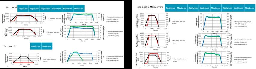
Producer Suite
Producer Suite empowers you to collect, process, analyze, and understand raw geospatial
data, and ultimately deliver usable information. This includes Hexagon’s Geospatial division
desktop-based GIS, remote sensing, and photogrammetry offerings.
ERDAS IMAGINE
ERDAS IMAGINE provides true value, consolidating remote sensing, photogrammetry, LiDAR analysis, basic
vector analysis, change detection, and radar processing into a single product.
New Platforms
With the ERDAS IMAGINE 2020 release, the ability to run as a true 64-bit application allows full exploitation of
the computer’s resources, including addressing more than 4GB of memory.
Image Chain Printing
Imagery that has been displayed using the Image Chain can now be included into Map Compositions, sent to
print devices, and included in Send To… operations (Send to PowerPoint, Send to JPEG, Send to Geospatial
PDF, etc).
Optimal Seamline Generation
Seamline generation is a crucial step in the
mosaicking workflow to create seamless
image mosaics. Images to be mosaiced
usually have radiometric inconsistences
and/or unresolved geometric misalignments.
Seamlines are generated with a goal of
avoiding such areas of radiometric
inconsistency and large misalignments so
that the resulting mosaic look seamless.
MIE4NITF
Time-series datasets are now being stored
and delivered in the MIE4NITF standard. This
can consist of hundreds, even thousands, of individual image frames stored in a NITF.
ERDAS IMAGINE 2020 has been enhanced to enable opening multiple MIE4NITF frames into tools such as
the Flicker tool in order to “play” the time-series, as well as being able to open individual frames for further
exploitation.
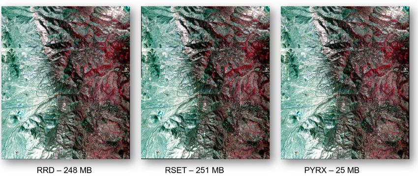
Create Image Pyramid
This operator ensures the existence of an image pyramid and statistics for an image dataset.
It produces or verifies the existence of a persistent, optimal sequence of images, each of which is
progressively lower in resolution than the preceding image in the sequence. The primary use of an image
pyramid is to increase rendering speed and reduce aliasing artifacts when visualizing the image at scales
larger than its original resolution.
29 October 2019 7
Enhance Contrast Using CLAHE
Techniques such as CLAHE were developed to spatially adapt the transformation and reveal the detail in dark
and bright areas of a raster while maintaining contrast in mid-tone areas. For example, CLAHE can enhance
hidden detail in the shadows cast by large buildings, clouds, etc.

GeoMedia
GeoMedia is a flexible and dynamic GIS package for creating, updating, managing, and analyzing your
valuable geospatial information. Generate and update vector layers. Perform dynamic spatial analysis and
generate reports. Automatically create and update maps. Manage data and map production more efficiently.
GeoMedia is available in three product tiers: Essentials, Advantage, and Professional.

29 October 2019                                                                                            8
Excel Data Server
This new data server provides access to tabular, nongraphic
data stored in Excel spreadsheets (XLSX, XLS) and structured
text files (CSV, TXT). Each text file is served as a warehouse
connection with a single feature class, while each spreadsheet
is served with feature classes for each sheet and each named
range. The feature classes are read-only and have no primary
key.

SQL Server Spatial Data Server
This data server now supports full read and write operations on
Microsoft SQL Server® Spatial native geometry fields that have
no companion GDO geometry field as established through
Database Utilities. This is true for area and line geometry fields
by default and is an option for point and compound fields. If you
choose this option, then point orientation will be lost because
native SQL Server geometry does not support orientation for points. This choice is not available for graphic
text or coverage fields because there is no native SQL Server geometry support for these.

This data server also now supports basic operations on SQL Server Spatial warehouses that lack GeoMedia
metadata. As with Oracle®, PostGIS, and GeoPackage, such connections are read-only, lack coordinate
reference system definitions for geometry fields, and lack GeoMedia metadata that influences presentation of
data.

Warehouse Connections Command
The Properties dialog of this command now allows the connection name to be changed.

Spatial Modeling
The operators Features Input and Features Database Output now support GeoPackage databases, and multi-
schema PostGIS databases.

New geometry manipulation operators Smooth Geometry and Densify Geometry are provided.

New grid operators Accumulate Flow, Calculate Flow, Fill Depressions, Find Watersheds, and Interpolate
Using IDW (inverse distance weighting).

Explorer Window
The treeview now reflects any GeoWorkspace
changes and is updated dynamically with added,
removed, and renamed categories, categorized
items, and queries, including retention of proper
sort order. It also reflects all Connection changes
and is updated dynamically with any change in
warehouse connection name.

An “Attached Data” branch is now introduced.
Raster files that are dropped into the
GeoWorkspace are presented here (for more information see the Drag-and-
drop section below). The groups of images represented there may be
added to a map window, or displayed in a data window, via the right-click
context menu. More functionality for attached data will be provided in future
releases.

29 October 2019                                                                                                9
Raster Band Selection
For an Image Style, a set of controls for color band assignment has been implemented, allowing selection of
which bands from a multi-band image are to be assigned to red, green, and blue display. On the Advanced
tab, the new style property BandAssignments is available, taking as input a comma-delimited string indicating
band numbers to be assigned to Red, Green, and Blue in that order. This style property may be assigned an
expression for attribute-based symbology.

Geotagged Images
A new command inserts geotagged images (images with embedded EXIF geotags) into a warehouse as point
feature classes with attributes capturing both the hyperlinked path to the image, and other characteristics from
geotags and other metatags. Another new command displays tagged photos and corresponding attributes by
moving the cursor over a point feature that contains geotags.

Drag-and-drop
Drag-and-drop capability within GeoMedia has now been extended to dragging raster files and warehouse files
from File Explorer and dropping them into either a map window or the Explorer window.

Raster files are attached to the GeoWorkspace and appear under “Attached Data” in the Explorer window.
They do not require a read-write warehouse connection. All raster file types supported by the Insert
Georeferenced Images command are supported for drag-and-drop, and they are automatically georeferenced.

Warehouse files are made into warehouse connections and appear under “Warehouse Connections” in the
Explorer window. The following file-based warehouse types are supported for drag-and-drop: GeoPackage,
Access, File Geodatabase, Shapefile, GeoMedia SmartStore, KML, and Excel.

If dropped into the Explorer window, only the attachments/connections are made. If dropped into a map
window, the data is additionally displayed.

ImageStation
The ImageStation software suite enables digital photogrammetry production workflows, including project
creation, orientation, and triangulation from aerial and satellite imagery. It also provides stereo GIS feature
collection and editing, digital terrain model (DTM) collection and editing, as well as orthophoto production and
editing. ImageStation is specially designed for high-volume photogrammetry and production mapping
customers who need to move large quantities of raw spatial information to an actionable or exploitable format.

New Platforms
ImageStation Stereo Display, ImageStation Feature Collection, and ImageStation DTM Collection were
modified to run with Power InRoads V8i and Power GEOPAK V8i in addition to MicroStation V8i. Although
MicroStation is not a requirement to run ImageStation Automatic Elevations (ISAE), if any of these V8i
products are found on the system while ISAE is installed, ISAE is enabled to write surface points and data out
to DGN files.

Satellite Support Enhancements
An option has been added to PhotoTX in ImageStation Automatic Triangulation that performs automatic tie
point matching for satellite projects. The option is available from the Select Project and Blocks dialog when
accessing PhotoTX or accessed from the Triangulation Options dialog from within PhotoTX. The bundle
adjustment in PhotoTX has been enhanced to support the adjustment of multi-segment scenes after automatic
point matching. Options to Withhold, Reinstate, and Delete point measurements have been added to the Point
Stats tab of PhotoTX.

29 October 2019                                                                                               10
DTM Collection Improvements
The DTM format has been modified to maintain the classification of points that are auto generated by
ImageStation Automatic Elevations (ISAE). ImageStation Stereo for GeoMedia and ImageStation DTM for
GeoMedia now recognize this classification and use it to properly color code points for display. The Custom
Edit commands in ImageStation Stereo for GeoMedia have been modified to update the classification of auto-
generated points to regular mass points after editing. The Input Files wizard in ISAE has been modified to
accept DTM format files as input morphological files. Previously, the wizard only accepted DGN format files.
This allows ImageStation Stereo for GeoMedia and ImageStation Stereo Display users to use model-wise
input DTM files to assist the ISAE matching process.

User-Defined Styles for DTM Features
A style library is now delivered by ImageStation DTM for
GeoMedia to the GeoWorkspaces\Libraries folder so that users
can customize the display of point and geomorphological
features in the Map and Stereo Windows in GeoMedia. The
ContourLabel feature class has defaulted to 50% translucent
frame, this can be changed by modifying the style. The Display
Frame option has been removed from the View Contours dialog
as it is now redundant with style settings in ContourLabel
feature class. Color codes that correspond to point classification
originating from ImageStation Automatic Elevations are also
defined in the style library.

Manual DTM Point Collection
Two new commands have been included in the ImageStation Stereo for GeoMedia Insert Feature menu list:
Generate Uncollected Points and Collect Points. These commands allow users to create a user-defined grid of
points for operator-assisted manual collection which can then be used with ImageStation DTM for GeoMedia
commands to generate surfaces.

Drape Features Command
A new Drape Features command has been added to ImageStation DTM for GeoMedia, allowing users to drape
existing features on surfaces to create new features with updated Z values.

Stereo Roam Performance Improvements
General stereo roam performance and stereo roam performance when placing linear features has been
 improved. A new Roam Parameters command has been added to both ImageStation Stereo for GeoMedia
and ImageStation Stereo Display, allowing users to calibrate various settings associated with roam mode
operations to adjust the processing for custom system configurations.

64-bit Mosaicking
The Mosaic process in ImageStation OrthoPro has been upgraded to a 64-bit process, allowing it to take
advantage of more system memory with processing speeds up to 14 times faster than before.

29 October 2019                                                                                           11
ECW Output
The rectify and mosaic processes in ImageStation OrthoPro
can now directly output ECW format without requiring
additional software and a separate conversion step. ECW
format provides exceptional compression, capable of reducing
terabyte-sized files to five percent of their original size while
retaining the image’s full visual quality. When you compress
your imagery into ECW format, the result is a much smaller
single file that can be stored, sent, and displayed even on
small devices.

Burn Features Command
A new Burn Features command has been added to
ImageStation PixelQue, allowing users to burn vector data
such as text, contours, and features into raster images.

3D Input Device Support
Support has been added for the Stealth Mouse Z-Type and Softmouse 3D USB devices to allow greater choice
of 3D input devices and easier ‘plug and play’ setup.

Provider Suite
                Provider Suite gives you the power to organize all your geospatial and business data into one
                centralized library and deliver it to others easily. Plus, powerful compression technology
                optimizes disk space requirements, and ultimately reduces your total cost of ownership.

ERDAS APOLLO
ERDAS APOLLO is a comprehensive data management, analysis, and delivery system. It enables an
organization to organize and deliver massive volumes of data, and consistently delivers geospatial data faster
and with less hardware than competing server-based products.

New Platforms
With the ERDAS APOLLO 2020 release, Java remains an external dependency in the server application and
now also the Data Manager. Microsoft Windows Server® 2019 has now been certified as a Supported Platform
for this release. For ERDAS APOLLO Essentials Linux® customers, support for Redhat v6.x has now been
deprecated. Now ERDAS APOLLO 2020 only supports v7.x based platforms, and once more widely available,
we intend to add support for v8.x in an upcoming update.

New Catalog Client
Soon after the general availability of ERDAS APOLLO 2020, a new, modernized web client will be released.
The client will be based on the LuciadRIA framework and serve as an integrated catalog client for both ERDAS
APOLLO and LuciadFusion, allowing federated search to bridge both server capabilities.

29 October 2019                                                                                             12
Advanced Logging Charts ERDAS APOLLO 2020 has greatly improved the user reporting and visual reporting of the existing detailed logging across the server. There are now general Upload and Download charts that allow administrators to see how often data is being ingested and used. AOI Notification Service ERDAS APOLLO 2020 now provides a capability for users to register defined areas of interest and receive a notification email when new data arrives, or existing data is updated that meets their requirements. Only someone with an admin role can register a user and create a notification region. However, any registered user in the system can be have a notification region created for them. ECWP Browser Streaming Lives Again Although the Enhanced Compression Wavelet Protocol (ECWP) has been valid for desktop systems since browsers discontinued plugin support, our previously deprecated Browser Plugin has been a commonly requested demand from many customers. Good news. A browser technology called WebAssembly that is combined with HTML5 Web Workers has now allowed us to revive ECWP for browser-based clients. GeoCompressor GeoCompressor is a stand-alone, high performance geospatial image and point cloud compression application designed to simplify the creation of ECW, JPEG2000, and HPC formats. Performance Improvements GeoCompressor 2020 delivers incremental performance improvements to continue satisfying our high- throughput customer data production demands. Performance throughput improvements up to 25% can be expected in some workflows. 29 October 2019 13
GeoCompresser Viewer
This GeoCompressor includes the first
release of GeoCompressor Viewer, a free to
use general purpose viewer for ECW,
JPEG2000 files designed to support rapid
user display but also QA from Data
Providers. It can also view imagery over the
internet via the ECWP protocol from an
ERDAS APOLLO Server.
ERDAS ECW JP2 SDK
The ERDAS ECW JPEG2000 SDK is a
developer toolkit that enables third-party
developers to read and write the industry
leading Hexagon Enhanced Compressed
Wavelet (ECW) and the ISO JPEG 2000
image compression formats. It also allows
applications to consume ECWP streams
delivered from ERDAS APOLLO server applications.
Performance Improvements
The ECWJP2 SDK has undergone lengthy internal code modernization to C++11 base standard, yielding
average performance gains of 15% and ensures Hexagon can continue supporting the numerous platforms our
customers demand across desktop, server, and mobile.
New Platform
The new ECWP for WebAssembly for web browsers allows plugin-less decoding of ECWP streams in web
pages to stream terapixel sized images from and to any device.
Platform Suite
Platform Suite enables you to deliver information through web, mobile, or cloud solutions.
Build and extend customized geospatial apps and solutions with a sophisticated set of
developer-focused technologies.
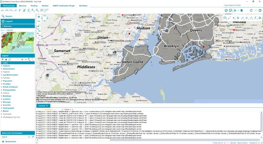
GeoMedia Smart Client
GeoMedia Smart Client is a GIS workflow management system that connects tasks and dependencies across
different roles in a process, and dynamically configures to reflect a users’ role and specific workflow steps. End
users can use advanced geospatial functionality via simple-to-use map-based tools, disentangling them from
nonessential tasks and focusing their time on their area of expertise. Workflow Manager is a standalone
product that is also a subset of GeoMedia Smart Client. Workflow Manager provides a rich toolset that lets you
construct highly focused business workflows that primarily support attributive data, but also may contain a
spatial component.
29 October 2019 14Platform Changes As a result of Oracle’s licensing changes, in GeoMedia Smart Client 2020, the default Java Development Kit has been replaced by OpenJDK as the standard virtual machine. With this change, GeoMedia Smart Client provides a solution based on a vendor-independent, resilient, and community-maintained technology stack. 4K Display Support in Workflow Manager With GeoMedia Smart Client 2020, you get a fully 4K supported Workflow Manager. A responsive design has been introduced to automatically select the best fitting resolution. Integrated Log Console With the new integrated log console, users can gain direct insights into the status of the application at runtime. The log messages are categorized into info, warnings, and errors. The console can be toggled by pressing the F12 key and is a powerful tool for testing and troubleshooting. 29 October 2019 15
GeoMedia® WebMap
GeoMedia WebMap supports a broad range of customers that require visualization and examination of
geographic data on the Web. From easily creating standards-compliant web services to providing sophisticated
visualization and analysis within interactive web mapping applications, GeoMedia WebMap builds powerful
solutions for sharing your organization’s rich geospatial data.

GeoMedia WebMap Mobile for Field Data Editing
In GeoMedia WebMap 2020, a new mobile application
for field data editing called GeoMedia WebMap Mobile is
a phone/tablet-based application for accessing,
portraying, and editing geospatial data. The user can
view, edit, validate, and update enterprise GIS data from
the field in real time. The updated data on the mobile
device is instantly available for the GIS platform used in
the same organization.

The core functionality in GeoMedia WebMap Mobile
comes from the Mobile MapWorks product. Mobile
MapWorks users will now find all the familiar functions
and features and more in GeoMedia WebMap Mobile. In
addition, because the workflows and available actions are
more intuitive and easier to navigate, the user’s experience is much
improved.

Mobile Publisher for GeoMedia WebMap Mobile Configurations
Mobile Publisher assists in the set-up and management of GeoMedia WebMap Mobile configurations by
addressing key aspects including user identification, field zone geometry specification, and field work
definitions. Mobile Publisher then generates the configuration files based on the Administrator’s selections.

29 October 2019                                                                                                 16
Performance Improvements
Several performance improvements have been added to GeoMedia WebMap 2020. Efficiency has been
enhanced when performing analyses on GeoMedia WebMap’s WFS feature classes in Geospatial Portal,
especially for data cases and queries, which processes filters using the database engine.

New Server Pools have been introduced to increase the reliability of a GeoMedia WebMap server and
guarantee critical services’ availability.

29 October 2019                                                                                     17
Geospatial Portal
Geospatial Portal is a fully featured, configurable, and customizable thin client application that can be used for
finding, viewing, querying, analyzing, and consuming geospatial data published by Hexagon Geospatial
products and/or other standards-based web services. The portal can be accessed by multiple users via web
browsers as it is installed and configured on a web application
server.
Enhanced Measurements in Geospatial Portal -
Consumer
Advanced measurement is one of the basic functionalities in
Geospatial Portal - Consumer. Users can measure distances and
areas on the map, as well as obtain geographic coordinates of
any given point.
The measurements results are displayed in the Measurements (right)
panel. With the 2020 release, the measurement details are also
displayed on the map including measuring a selected area, linear
measurements, and coordinates.
Groups for Layers in Geospatial Portal - Consumer
Geospatial Portal - Consumer displays the layers grouped under the name of the
service the layers come from. Users can change the layer order within the group
by drag and drop of individual layer, switch the layer on/off, or modify its opacity
for optimal map display.
Support for Custom Layer Graphics in Geospatial Portal - Consumer
WMS services may provide custom legend graphics that bring detailed information
about presented phenomena. With the 2020 release, the custom graphics are
displayed in the legend item control beside the layer name.
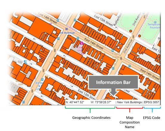
29 October 2019 18Information Bar in Geospatial Portal – Consumer Geographic latitude and longitude for the current cursor position in a map window is displayed in the bottom right corner on the screen application. The name of active Map Composition is displayed in the bottom right corner. The coordinate system EPSG code of the current map is visible on the information bar as well. Extrude Analysis Results in Geospatial Portal - Classic Geospatial Portal - Classic supports extrusion of 2D vector features into three dimensional solid shapes to build 3D scenes in seconds. The extrusion can be also applied to the layers resulting from the analyses based on selected attribute values and this way introduce extra information on the map. Note: Extrusion only works with data from GeoMedia WebMap’s Web Feature Services. Display Extruded Data in Geospatial Portal – Consumer With Geospatial Portal - Classic users can extrude two-dimensional vector features and view them in 3D scenes. Now users can view 3D scenes with extruded features in Geospatial Portal - Consumer as well. The highlight style for selectable WFS objects is customizable. 29 October 2019 19
Contact Us

       https://go.hexagongeospatial.com/contact-us-today

About Hexagon
Hexagon is a global leader in sensor, software and autonomous solutions. We are putting data to work to boost efficiency,
productivity, and quality across industrial, manufacturing, infrastructure, safety, and mobility applications.

Our technologies are shaping urban and production ecosystems to become increasingly connected and autonomous —
ensuring a scalable, sustainable future.

Hexagon’s Geospatial division creates solutions that deliver a 5D smart digital reality with insight into what was, what is,
what could be, what should be, and ultimately, what will be.

Hexagon (Nasdaq Stockholm: HEXA B) has approximately 20,000 employees in 50 countries and net sales of
approximately 4.3bn USD. Learn more at hexagon.com and follow us @HexagonAB.

29 October 2019                                                                                                                20
Copyright
© 2019 Hexagon AB and/or its subsidiaries and affiliates. All rights reserved. Hexagon has registered
trademarks in many countries throughout the world. Visit the Trademarks Page
http://www.hexagongeospatial.com/legal/trademarks for information about the countries in which the
trademarks are registered. See Product Page and Acknowledgments for more information.
Product Documentation Terms of Use
PLEASE READ THESE TERMS CAREFULLY BEFORE USING HEXAGON GEOSPATIAL’S
DOCUMENTATION ("DOCUMENT"). USE OF THIS DOCUMENT INDICATES ACCEPTANCE OF THIS
AGREEMENT WITHOUT MODIFICATION. IF YOU DO NOT AGREE TO THE TERMS HEREOF ("TERMS"),
DO NOT USE THIS DOCUMENT.
Use Of This Document
All materials in this Document are copyrighted and any unauthorized use may violate worldwide copyright,
trademark, and other laws. Subject to the terms of this Agreement, Hexagon Geospatial (a Division of
Intergraph Corporation) and Intergraph’s subsidiaries ("Intergraph") hereby authorize you to reproduce this
Document solely for your personal, non-commercial use. In consideration of this authorization, you agree to
retain all copyright and other proprietary notices contained therein. You may not modify the Materials in any
way or reproduce or publicly display, perform, or distribute or otherwise use them for any public or commercial
purpose, except as specifically authorized in a separate agreement with Hexagon Geospatial.
The foregoing authorization specifically excludes content or material bearing a copyright notice or attribution of
rights of a third party. Except as expressly provided above, nothing contained herein shall be construed as
conferring by implication, estoppel or otherwise any license or right under any copyright, patent or trademark of
Hexagon Geospatial or Intergraph or any third party.
If you breach any of these Terms, your authorization to use this Document automatically terminates. Upon
termination, you will immediately destroy any downloaded or printed Materials in your possession or control.
Disclaimers
ALL MATERIALS SUPPLIED HEREUNDER ARE PROVIDED "AS IS", WITHOUT WARRANTY OF ANY
KIND, EITHER EXPRESSED OR IMPLIED, INCLUDING, BUT NOT LIMITED TO, ANY IMPLIED
WARRANTIES OF MERCHANTABILITY, FITNESS FOR A PARTICULAR PURPOSE, OR NON-
INFRINGEMENT. Hexagon Geospatial does not warrant that the content of this Document will be error-free,
that defects will be corrected, or that any Hexagon Geospatial Website or the services that make Materials
available are free of viruses or other harmful components.
Hexagon Geospatial does not warrant the accuracy and completeness of this Document. Hexagon Geospatial
may make changes to this Document at any time without notice.
Limitation Of Liability
IN NO EVENT SHALL HEXAGON GEOSPATIAL BE LIABLE FOR ANY DIRECT, INDIRECT, INCIDENTAL,
SPECIAL OR CONSEQUENTIAL DAMAGES, OR DAMAGES FOR LOSS OF PROFITS, REVENUE, DATA
OR USE, INCURRED BY YOU OR ANY THIRD PARTY, WHETHER IN AN ACTION IN CONTRACT OR
TORT, ARISING FROM YOUR ACCESS TO, OR USE OF, THIS DOCUMENT.
Indemnification
29 October 2019 21You agree to defend, indemnify, and hold harmless Hexagon Geospatial, its officers, directors, employees, and
agents from and against any and all claims, liabilities, damages, losses or expense, including reasonable
attorneys' fees and costs, arising out of or in any way connected with your access to or use of this Document.
Use Of Software
Use of software described in this Document is subject to the terms of the end user license agreement that
accompanies the software, if any. You may not download or install any software that is accompanied by or
includes an end user license agreement unless you have read and accepted the terms of such license
agreement. Any such software is the copyrighted work of Hexagon Geospatial, Intergraph or its licensors.
Portions of the user interface copyright 2012- Telerik AD.
Links To Third Party Websites
This Document may provide links to third party websites for your convenience and information. Third party
websites will be governed by their own terms and conditions. Hexagon Geospatial does not endorse
companies or products to which it links.
Third party websites are owned and operated by independent parties over which Hexagon Geospatial has no
control. Hexagon Geospatial shall not have any liability resulting from your use of the third party website. Any
link you make to or from the third party website will be at your own risk and any information you share with the
third party website will be subject to the terms of the third party website, including those relating to
confidentiality, data privacy, and security.
Trademarks
The trademarks, logos and service marks ("Marks") displayed in this Document are the property of Hexagon
Geospatial, Intergraph or other third parties. Users are not permitted to use Marks without the prior written
consent of Hexagon Geospatial, Intergraph or the third party that owns the Mark. "Intergraph" is a registered
trademark of Intergraph Corporation in the United States and in other countries. Other brands and product
names are trademarks of their respective owners.
Find additional trademark information http://www.hexagongeospatial.com/legal/trademarks.
Procedure For Making Claims Of Copyright Infringement
Notifications of claimed copyright infringement should be sent to Hexagon Geospatial by mail at the following
address: Intergraph Corporation, Attn: Intergraph Legal Department, P.O. Box 240000, Huntsville, Alabama
35824.
US Government Restricted Right
Materials are provided with "RESTRICTED RIGHTS." Use, duplication, or disclosure of Materials by the U.S.
Government is subject to restrictions as set forth in FAR 52.227-14 and DFARS 252.227-7013 et seq. or
successor provisions thereto. Use of Materials by the Government constitutes acknowledgment of Hexagon
Geospatial or Intergraph’s proprietary rights therein.
International Use
You may not use or export Materials in violation of U.S. export laws and regulations. Hexagon Geospatial
makes no representation that Materials are appropriate or available for use in every country, and access to
them from territories where their content is illegal is prohibited.
Hexagon Geospatial provides access to Hexagon Geospatial international data and, therefore, may contain
references or cross references to Hexagon Geospatial products, programs and services that are not
29 October 2019 22announced in your country. These references do not imply that Hexagon Geospatial intends to announce such products, programs or services in your country. The Materials are subject to U.S. export control and economic sanctions laws and regulations and you agree to comply strictly with all such laws and regulations. In addition, you represent and warrant that you are not a national of, or otherwise located within, a country subject to U.S. economic sanctions (including without limitation Iran, Syria, Sudan, Cuba, and North Korea) and that you are not otherwise prohibited from receiving or accessing the Materials under U.S. export control and economic sanctions laws and regulations. Hexagon Geospatial makes no representation that the Materials are appropriate or available for use in every country, and access to them from territories where their content is illegal is prohibited. All rights to use the Materials are granted on condition that such rights are forfeited if you fail to comply with the terms of this agreement. Revisions Hexagon Geospatial reserves the right to revise these Terms at any time. You are responsible for regularly reviewing these Terms. Your continued use of this Document after the effective date of such changes constitutes your acceptance of and agreement to such changes. Applicable Law This Document is created and controlled by Hexagon Geospatial in the State of Alabama. As such, the laws of the State of Alabama will govern these Terms, without giving effect to any principles of conflicts of law. You hereby irrevocably and unconditionally consent to submit to the exclusive jurisdiction of the United States District Court for the Northern District of Alabama, Northeastern Division, or the Circuit Court for Madison County, Alabama for any litigation arising out of or relating to use of this Document (and agree not to commence any litigation relating thereto except in such courts), waive any objection to the laying of venue of any such litigation in such Courts and agree not to plead or claim in any such Courts that such litigation brought therein has been brought in an inconvenient forum. Some jurisdictions do not allow the exclusions or limitations set forth in these Terms. Such exclusions or limitations shall apply in all jurisdictions to the maximum extent allowed by applicable law. Questions Contact us https://www.hexagongeospatial.com/about-us/our-company/contact-us with any questions regarding these Terms. 29 October 2019 23
You can also read