Whatever Happened to Georgia's Dixie Highway?
←
→
Page content transcription
If your browser does not render page correctly, please read the page content below
Whatever Happened to
Georgia’s Dixie Highway?
                                                BY ED JACKSON

Occasionally in Georgia, you will see an “Old Dixie Highway” street sign. You may wonder what the Dixie
Highway is (or more appropriately was). Built mostly between 1915 and 1927, the Dixie Highway was the first
north-south interstate paved highway in the U.S., stretching from the Canadian border to Miami, Florida.

As late as 1910, few highways existed in America, and inter-city highways were considered an unneeded luxury
in most of the South. People rode the train to travel any distance inland. Locally, they traveled by wagon,
buggy, or city streetcar. Very few paved roads existed in America, except for brick and concrete streets in large
cities. So-called “improved roads” outside the cities were typically graded dirt, clay, or gravel. Across the
nation, but especially in the South, most roads were filled with ruts that turned into mud when it rained.

In one sense, the Dixie Highway was an outgrowth of the Good Roads Movement, a national effort launched in
the 1890s by bicycle clubs but joined by automobile owners who had experienced what it was like to drive on
dirt roads—especially after a hard rain. The U.S. Post Office supported better roads for its Rural Free Delivery
service routes, and farmers desired reliable roads to get their crops to market.

Although there were a variety of voices calling for better roads, it is
Carl Fisher who is considered the Father of the Dixie Highway.
Fisher was an entrepreneur, promoter, land speculator, and auto
enthusiast. In 1912, he purchased an undeveloped island that would
later become Miami Beach, Florida, in hopes of creating a winter
vacation mecca for snowbirds from Midwestern states. Henry Ford’s
Model T offered an affordable means of travel, but Fisher knew that
one essential thing was missing – a paved highway that could
withstand heavy rain.

In 1914, Fisher proposed a north-south paved highway to connect
Chicago with Miami. He asked Indiana governor Samuel Ralston to
contact fellow governors to meet and discuss what Fisher had
dubbed the Dixie Highway. At the first meeting, held in April 1915
in Chattanooga, Tennessee, the Dixie Highway Association (DHA)
was formed. The DHA embarked on an unlikely goal– to build an
interstate highway without federal or state money or regulations.
Local leaders would have to fund and oversee paving the highway through their individual counties.

Numerous cities and counties in different states wanted to be on the Dixie Highway–but it was impossible to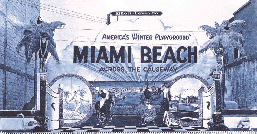
accommodate every request. Once Michigan and the Carolinas joined the
DHA, officials decided to have a Dixie Highways West and a Dixie
Highway East– with Sault Ste. Marie, located in Upper Michigan on the
Canadian border, as the northern terminus. From there, both highways
would run roughly parallel routes southward, converging in Miami.
As interest spread, the association decided to allow connecting highways
between the main Dixie Highway routes. The result was a network of roads
all claiming the name Dixie Highway. To the extent possible, the Dixie
would follow existing roadbeds. Because many roads did not cross county
or state lines, a lot of new road construction was needed.
Initially, community leaders and auto enthusiasts contributed money for
paving the Dixie in their county. But, often that was not enough–so, many
counties held bond referendums. As a result, the Dixie varied in width,
appearance, composition, and durability from county to county. In some
cases, it was clay, gravel, or a dirt road coated with sprayed tar. In a few
cases, it was built of brick or shell. In most cases, the pavement was
concrete or a mixture of crushed stone sealed with tar or asphalt.
Construction of the Dixie Highway began in 1915 by a loose confederation
of counties. That changed in 1916, when
Congress passed the Federal Aid Road
Act. States wishing to receive the limited The Dixie Highway network from Sault
Ste. Marie, Michigan, to Miami, Florida.
funding provided by the act were required
to create a state highway agency, and in
1916 Georgia complied.
In 1917, construction of the Dixie Highway was stalled by World War I. After
the war, the prosperity of Roaring Twenties meant more Americans had jobs with good salaries. Many families
now had the means to own an automobile and take extended vacations. With the coming of the auto age, the
Dixie Highway was heralded as an avenue to allow snowbirds to escape the winter cold by vacationing in the
South–especially Florida.
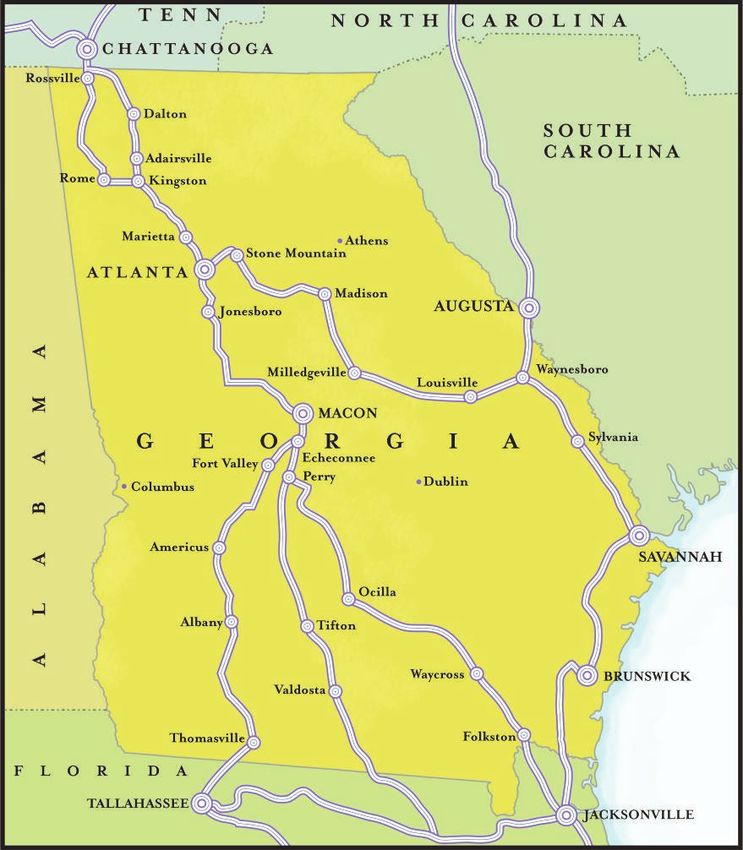
Because of Georgia’s location, both routes of the Dixie Highway extended through it. Connecting routes and a
loop through Rome were added to the network. The most important connector was formally designated the
“Central Dixie Highway.” It departed the Dixie Highway West at Macon, heading southeast to Waycross on to
Jacksonville, where it joined the Dixie Highway East. (see map on page 3)
In 1921, the Georgia General Assembly imposed a one-cent per gallon motor fuel tax to raise funds for road
construction. That same year, new federal legislation provided states with increasing amounts of funding for two
-lane interstate roads. This allowed Georgia’s State Highway Department to assume responsibility for road
construction and maintenance, including the Dixie Highway. The motor fuel tax was raised to three-cents per
gallon in 1923.
In 1926, highway officials gave all federally funded highways numbers instead of names. The Dixie Highway
was not given a single U.S. highway number. Instead, segments of the Dixie were incorporated into different
newly numbered highways. (see map on page 4)
By 1927, the Dixie Highway Association considered its goal achieved and disbanded. In reality, however,
portions of the Dixie Highway in Georgia remained unpaved until 1939.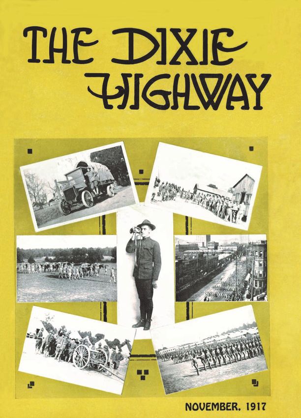
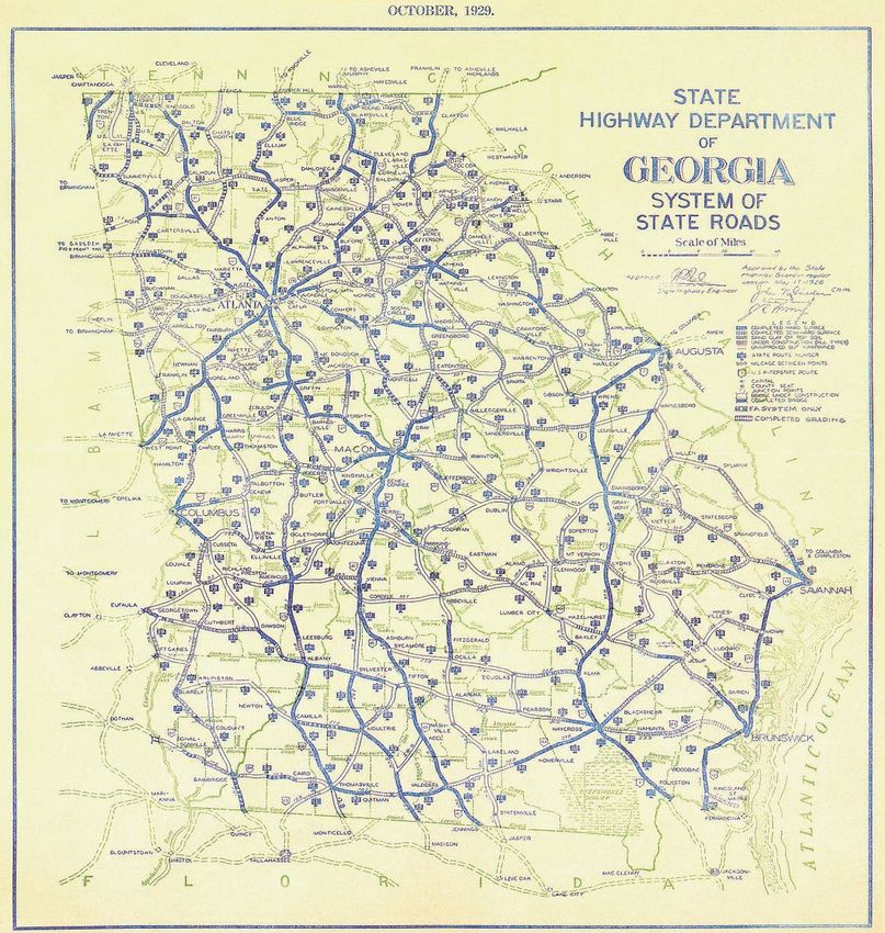
Dixie Highway Routes Through Georgia, 1924

               Map created based on the research of Ed Jackson

Both routes of the Dixie Highway extended through Georgia. The Dixie Highway West entered northwest Georgia at Rossville,
proceeding south to Dalton, Marietta, and Atlanta. Rome was included on the route through a DHA authorized loop. The Dixie
Highway West went into downtown Atlanta, then proceeded south to Jonesboro and Macon. South of Macon, it took a
southwesterly route through Fort Valley, Americus, Albany, Thomasville, and on to Tallahassee—then through central Florida
to Miami.

The Dixie Highway East entered Georgia from South Carolina at Augusta, continuing on a southeastern route to Waynesboro,
Sylvania, Savannah, Jacksonville, and down the eastern Florida coast to Miami.

In 1916, DHA authorized two east-west connecting highways. The northern connector went from Atlanta to Stone Mountain,
Madison, Milledgeville, and Louisville, finally connecting with the Dixie Highway East at Waynesboro. The longer connector
was formally designated the “Central Dixie Highway.” It departed the Dixie Highway West at Echeconnee south of Macon,
continuing south to Perry, then southeast to Waycross, Folkston, and Jacksonville, where it joined the Dixie Highway East.

After taking over responsibility for paving the Dixie Highway in 1919, Georgia’s State Highway Department placed a high
priority on paving the road from Perry to Tifton to Valdosta and on to the Florida border (a route designated U.S. 41 in 1926).
Because of the route’s popularity, the Dixie Highway Association added the Perry-Valdosta route to the Dixie Highway
network in 1924, though never formally designating it with a title.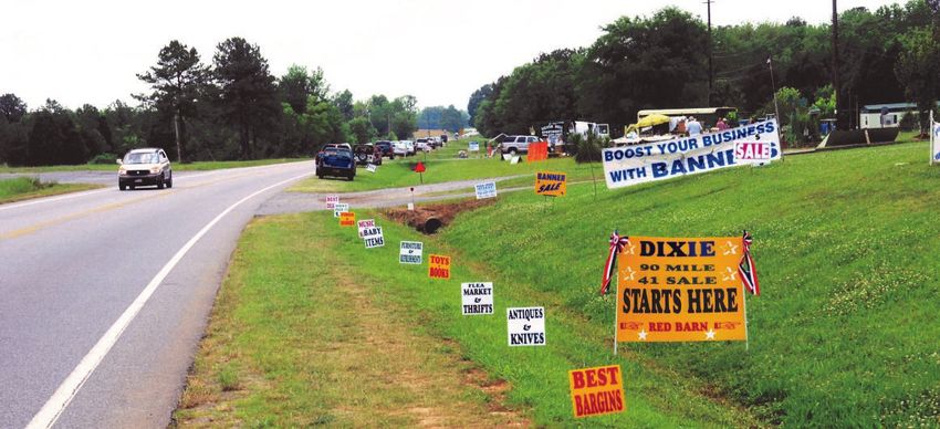
1929 Georgia Highway Map
Courtesy of Ed Jackson

The Dixie Highway West from Rossville to Atlanta to Macon to Valdosta and southward into Florida became U.S.
41. South of Macon, the original route departed from U.S. 41 at Echeconnee and proceeded southwest on Ga. 49
to Americus, where it followed U.S. 19 to Albany, Thomasville, and Tallahassee.

The Dixie Highway East entered Georgia from South Carolina at Augusta on what was designated U.S. 25,
continuing to Waynesboro, where it took Ga. 24 on a southeastern route to U.S. 301, then proceeding to Sylvania,
where it followed Ga. 21 to Savannah. From Savannah, the eastern route followed U.S. 17 to Jacksonville, where
the Dixie Highway became U.S. 1.
Building the Dixie Highway

                                              In the first decade of the 20th century, Georgia did not have a highway department,
                                              and road construction and maintenance were strictly city and county functions
                                              performed mainly by county and state prisoners.

Considered the Father of the Dixie
Highway, Carl Fisher proposed the north-
south paved highway to connect Chicago
with Miami.

Concrete Dixie Highway in central Georgia, 1927.                          Some poorer counties on the Dixie Highway
                                                                          connectors could only afford to spray tar on a graded
                                                                          dirt road.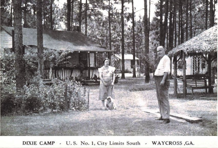
The Dixie Highway Magazine

         The Dixie Highway magazine was published by the Dixie Highway Association from
         1916 to 1926. It had national subscribers and was full of information on the
         importance of the highway, the status of its completion, and recommendations for
         motorists on a variety of matters.

         This issue of the Dixie Highway magazine stressed the military importance of the
         Dixie Highway, which ran through Fort Oglethorpe near Rossville. The magazine
         details the results of tests to see how quickly and efficiently Army trucks could be used
         to haul supplies and troops from Fort McPherson in Atlanta to Fort Oglethorpe. The
         importance of highways to the military was later used as a rationale for Congress
         authorizing the Interstate Highway System in in 1956.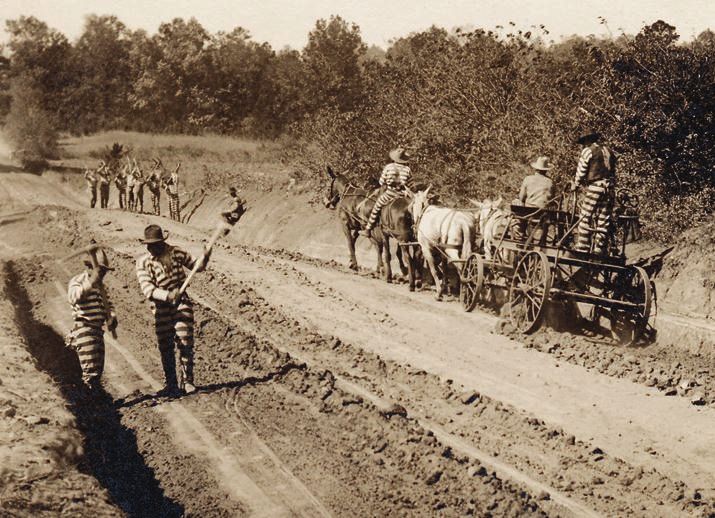
Legacy of the Dixie Highway
Almost immediately, construction of the Dixie Highway
gained national attention. Prior to 1915, winter resort hotels
in Florida were accessible and affordable only to the well-to
-do. The Model T and Dixie Highway changed that,
bolstering Florida as both a year-around vacation site and a
place to live. In 1920, a land boom began in Palm Beach
County. Word spread across the country that a fortune
could be made buying and selling land in Florida, and a
land rush followed. Tens of thousands of speculators and
families loaded up their cars and headed south on the Dixie
Highway to Florida. Swamps were drained and quickly sold
to eager buyers, who hoped to re-sell the land at a big profit
to newcomers. This worked for while, but the bubble burst
in 1926. Many families who had come to Florida to get rich
now had difficulty finding gas money to return home.
The Dixie Highway was one of the early examples of the
economic impact of highway construction. Under the best
of conditions, a trip from Chicago or Detroit to Miami could take two weeks. While hotels and restaurants along
the way benefitted from some travelers, many families could not afford to eat out or stay in a hotel each night of
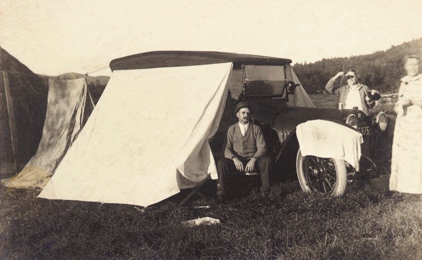
their trip. So, they packed a tent and everything needed to camp out along the way—often loaded into a small,
open trailer pulled behind their car. Families would set up camp in an open field or at a church or school along
the way and then be on their way in the morning—hopefully before anyone noticed them.
Eventually entrepreneurs along the highway created tourist camps. For as little as a quarter families could set
up their tents and enjoy the luxury of water and a bathroom. In some cases, towns would set aside an area of
land for Dixie Highway travelers to camp–sometimes without charge in the hopes of attracting tourist dollars.
Local grocers and restaurant owners complained about what they called “tin can tourist camps” because most of
the travelers brought their own food with them in tin cans. The name became a point of pride to the “tin can
campers,” who later adopted a tradition of holding tin can
camp reunions.
Tourist camp owners began adding small cabins for
travelers. Initially these were known as tourist courts and
were the primitive precursors of what more fashionably
became known as motor courts, motor hotels, and finally
motels. Thousands of “mom and pop” travel camps and
lodges developed along the Dixie Highway. Joining these
were gas stations, auto repair shops, small restaurants,
grocers, fruit and pecan stands, souvenir shops (many of
which had chenille bedspreads displayed outside for sale),
and other enterprises.
By the 1930s, small camping trailers were becoming popular. They were followed by small trailer homes,
which contained a tiny sofa, table, kitchen, and bed (though no bathroom). After World War II, trailers became
larger and included a bathroom. Not only could families vacation in Florida inexpensively, many older couples
from colder climates decided to live there permanently in one of the exploding number of trailer parks for
retirees. Almost all of Florida’s growing population would travel down the Dixie Highway through Georgia.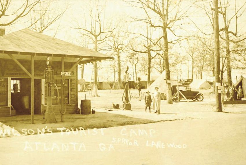
Camping Along the Dixie Highway

In the early years of the Dixie Highway, many families could not afford to stay in a hotel each night of their trip, so they
would pull off the road and set up a tent in an open field or in a church or school yard.

Ford Model-T pulling camping trailer                                     Ad for the Auto-Kamp Trailer
Camping Along the Dixie Highway

        Many tourist camps and lodges were operated by husbands and wives, such as the case with
        the Dixie Camp, which was located on the Central Dixie Highway (U.S. 1) south of
        Waycross.

        Wilson’s Tourist Camp was located south of Atlanta just off the Dixie Highway near
        Lakewood. Here travelers could set up a tent. The owner also sold gas, auto supplies,
        repaired tires, and probably had a few grocery items for sale.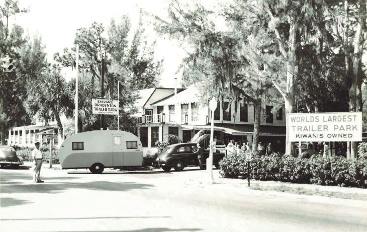
Florida via the Dixie Highway

                                Model-T with Illinois license plate parked at Miami Beach, 1922.

Miami Beach sign
Florida via the Dixie Highway
Bradenton Trailer Park
Florida trailer park
Buyers waiting in line to buy lots on Davis
Islands owned by famous developer D.P.
Davis.
In 1924 and 1925, during the height of the
Florida land boom, potential buyers would
wait hours in the hot sun for a chance to
buy a piece of Florida real estate with the
hopes of turning around and selling it at a
much higher rate. Easy credit and a strong
belief that land prices would continue to
climb in value fueled the real estate frenzy.The Dixie Highway Today
Today, the Dixie Highway is mainly a memory—though a few reminders
remain. The old Dixie Highway still runs through Adairsville, and short
segments elsewhere can be found. Occasionally, you’ll see the remains of
what once was a motel that served travelers. But, most of the original
highway is gone, renamed, paved over, or re-routed to newer highways. The
final death knell of the Dixie Highway as a contiguous, driveable route
came in the 1970s, when the final portions of I-75 and I-95 in Georgia were
completed.
Amazingly, despite its importance to Georgia and to motorists driving to Georgia Dixie Highway Association
Florida, there is a single state historical marker plus several stone markers in Logo. The Dixie Highway 90-mile Yard
Sale is hosted by the GDHA.
Georgia dedicated to the Dixie Highway. But each spring, the highway’s
name resurfaces in what is called the “Dixie Highway 90-mile Yard Sale”—a 90-mile venture between
Ringgold and Acworth, Georgia, where residents set up tents in their front yard with junk or treasure for sale.
Dixie Highway 90-mile Yard Sale
GHS is partnering with GDOT and the Federal Highway Association on a project coordinated by New South
Associates to study and document the Dixie Highway. The Society’s library and archives will be the repository
of records collected during the project.
Ed Jackson is Senior Public Service Associate Emeritus at the University of Georgia. He can be reached at
edjack.uga.edu
All images in this article are courtesy of Ed Jackson.You can also read