Willoughby NDP - First Draft Plan V6 September 26, 2018
←
→
Page content transcription
If your browser does not render page correctly, please read the page content below
Willoughby NDP - First Draft Plan V6       September 26, 2018

                                       1
Willoughby NDP - First Draft Plan V6                                     September 26, 2018

        Note - all maps prepared or reproduced under Ordnance Survey Willoughby Parish Council
                                                               (Licensee) License No. 00051782

                                              2
Willoughby NDP - First Draft Plan V6                                                                                  September 26, 2018

Contents

Public Consultation ............................................................................................................................... 4
1.0        What is a Neighbourhood Development Plan? ........................................................................ 5
2.0        A Neighbourhood Development Plan for Willoughby .............................................................. 8
3.0        Vision and Objectives .............................................................................................................. 11
4.0        NDP Draft Planning Policies .................................................................................................... 13
4.1        Introduction ............................................................................................................................ 13
4.2        Protecting and Enhancing our Rural Landscape ..................................................................... 15
4.3        Local Green and Blue Infrastructure ....................................................................................... 26
4.4        Conserving and Enhancing our Built Heritage Assets ............................................................. 31
4.5        Encouraging High Quality and Sustainable Design ................................................................. 35
4.6        Providing Homes ..................................................................................................................... 39
4.7        Supporting Small Businesses and Home Working .................................................................. 45
4.8        Protecting and Improving Local Facilities and Services .......................................................... 48
5.0        Next Steps ............................................................................................................................... 53
6.0        Non-Planning Issues and Concerns ......................................................................................... 54
Appendices.......................................................................................................................................... 55
   Appendix 1             Historic Landscape Character ................................................................................. 56
   Appendix 2             Listed Buildings in Willoughby Parish ..................................................................... 58
   Appendix 3             Proposed Non-Designated Heritage Assets ............................................................ 61
   Appendix 4             Character Areas....................................................................................................... 76
   Appendix 5             Housing Development in Willoughby Parish since the 1960s................................. 87
   Appendix 6             List of Local Businesses in Willoughby Parish ......................................................... 88
   Appendix 7             Local Facilities and Services .................................................................................... 89

                                                                          3
Willoughby NDP - First Draft Plan V6                                          September 26, 2018

       Public Consultation

       Welcome to the Willoughby (NDP) First Draft Plan. This document is published for
       informal public consultation from 8 October to 4 November 2018.

       Public consultation is a very important part of preparing Neighbourhood Development
       Plans. This First Draft Plan has been prepared by the NDP Steering Group of local
       residents and a parish councillor following the consultation on Issues and Options in
       summer 2018. The Draft NDP sets out draft policies to shape new development in
       Willoughby parish up to 2031 and these have been prepared taking into account local
       residents' and stakeholders' comments and ideas.

       We need to know:
       • Is there anything important that you think we have missed?
       • Will these draft planning policies help to guide new development in a positive way
           so that changes are sensitive to Willoughby’s distinctive character as a rural village
           with historic and environmental assets set within attractive countryside?
       • Do you have any detailed comments about the draft vision, objectives or any of
           the NDP planning policies?

       A summary document has also been prepared for this consultation.

       You can comment on this First Draft Plan in the following ways:
       • Online at https://www.surveymonkey.co.uk/r/WilloughbyNDP2
       • By returning the paper questionnaire delivered to all households to:
           o Church View, Lower Street,
           o B Beautiful, Lower Street
           o 16 Main Street
       • By coming along to the second Neighbourhood Development Plan Day on
           Wednesday 17 October from 4.00pm to 8.00pm at the village hall.

       Next Step: After this informal consultation we will consider all submitted responses
       and revise the Draft Neighbourhood Development Plan for formal public consultation
       (Regulation 14) later in 2018 or in early 2019.

               Chair of Parish Council                       Chair of Steering Group

                                                 4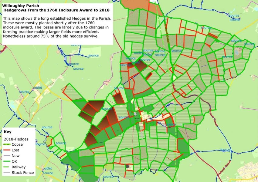
Willoughby NDP - First Draft Plan V6                                          September 26, 2018

1.0 What is a Neighbourhood Development Plan?

      Neighbourhood Development Plans (NDPs) are a new type of planning policy
      document, prepared by parish councils and other bodies to guide new development
      within a defined area, such as a parish. They are used alongside local authority (here,
      Rugby Borough Council) and national planning policy documents, to help determine
      planning applications.

      NDPs are important planning documents and give local people the opportunity to
      have a real say in how, and where, development should happen within their local
      area. They can provide the local detail to add value to higher level, more strategic
      policies such as Rugby Borough Council’s adopted Core Strategy (2011) and the Saved
      Local Plan policies (2011).

1.1    Neighbourhood Development Plans (NDPs) were introduced through the Localism Act
       2011 to give local people a greater say in planning decisions that affect their area.
       NDPs are neighbourhood level planning policy documents with policies designed to
       reflect the needs and priorities of local communities.

1.2    NDPs can identify where development should take place, set out local design
       principles so that buildings respond positively to local character, and protect
       important facilities, historic buildings, the natural environment and open spaces. They
       are an important part of our planning system because planning applications are
       determined in accordance with the development plan unless material considerations
       indicate otherwise. Made (adopted) NDPs are part of the local statutory development
       plan for their area.

1.3    A Neighbourhood Development Plan (NDP) can cover a range of planning related
       issues or just have one, single policy. This document has been prepared building on
       the responses to the public consultation on Issues and Options which was undertaken
       earlier this year from 7 May to 3 June. The Issues and Options document set out a
       proposed draft vision and objectives for the NDP and asked residents about a range of
       planning issues and potential policies for addressing these issues. This First Draft Plan
       provides more detail in terms of background and supporting evidence and sets out
       wording for ten draft planning policies. The Neighbourhood Development Plan and its
       policies should be read as a whole. Proposals will be assessed against all relevant
       policies.

1.4    It is important to remember that NDPs cannot be prepared in isolation. They have to
       be ‘in general conformity’ with local strategic planning policies - in this case, Rugby

                                                 5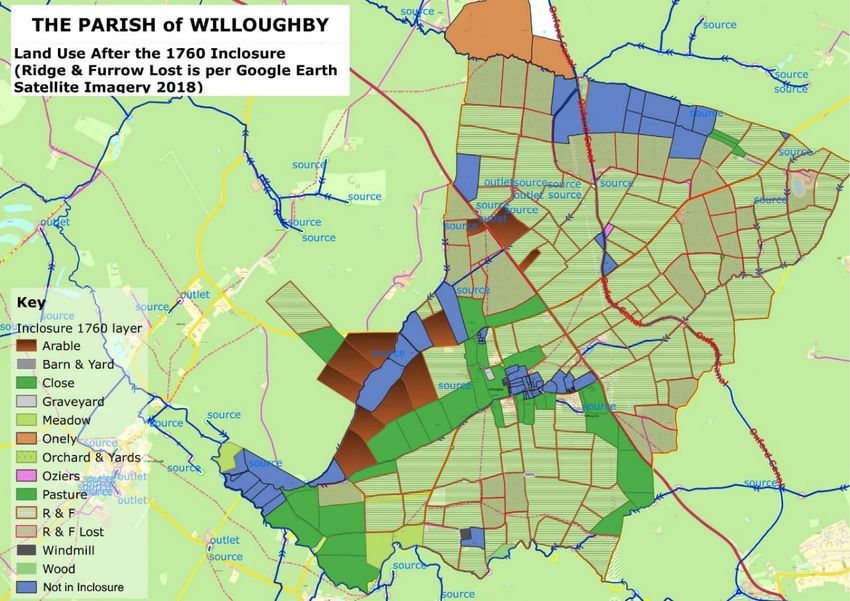
Willoughby NDP - First Draft Plan V6                                           September 26, 2018

        Borough Council’s adopted Core Strategy (2011) and the Saved Local Plan policies
        (2011)1.

1.5     Planning Practice Guidance2 also advises that the reasoning and evidence informing
        the policies and proposals in an emerging Local Plan should be taken into
        consideration during the preparation of the NDP. Therefore, the Willoughby Draft
        NDP also notes the policies in Rugby’s emerging Local Plan 2011 - 2031, including the
        Main Modifications which were published for consultation from 14 August to 5
        October 2018. NDPs must also have regard to national planning policy - the revised
        National Planning Policy Framework (2018)3 and other guidance and statements.

1.6     All the Neighbourhood Development Plan planning policies have to be underpinned by
        a clear and robust evidence base of local opinion and technical resources and, overall,
        the Plan has to meet a set of ‘basic conditions’ set out in national guidance.

1.7     Preparing an NDP is a complex and lengthy process. This is set out in Figure 1 below.
        Following this period of informal public consultation, we are hoping to finalise our
        Willoughby Draft NDP for the required 6 weeks formal consultation in late 2018 or
        early 2019. The Plan then will be revised again and submitted to Rugby Borough
        Council who will check it and publish it for another 6 weeks consultation.

                Figure 1: Neighbourhood Development Plan Process

                                       Preparing the Plan               Consult on Draft
                                                                              Plan
           Designation                     (WE ARE HERE)
                                                                           (6 weeks)

            Rugby Borough                 Submit Plan to                    Revise Plan
            Council consult               Rugby Borough
             for 6 weeks                     Council

             Examination                    Referendum
                                                                            NDP Made

1.8     The NDP will be examined by an independent Examiner, who is likely to recommend
        further changes. After the Inspector’s report is published and the changes made, the
        NDP will be taken to Rugby Council's Cabinet for approval to make the Plan subject to

1
  https://www.rugby.gov.uk/info/20004/planning_strategy
2
  https://www.gov.uk/government/collections/planning-practice-guidance
3
  https://www.gov.uk/government/publications/national-planning-policy-framework--2

                                                  6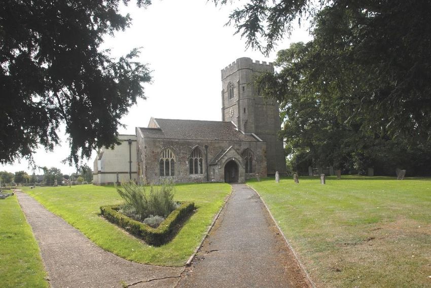
Willoughby NDP - First Draft Plan V6                                         September 26, 2018

       the outcome of the Referendum. If the outcome of the Referendum is a majority Yes
       vote (50% of turnout + 1), the Plan will be made by Rugby Borough Council and used to
       help determine planning applications alongside Rugby’s planning policies and national
       policy.

1.9    There are therefore several stages of public consultation and engagement throughout
       the process and the Neighbourhood Plan can only be made if, at the very end, local
       people support it.

1.10   We hope to achieve all this and have a Plan in place during the second half of 2019.
       We need your help and ideas to do this successfully.

                                                7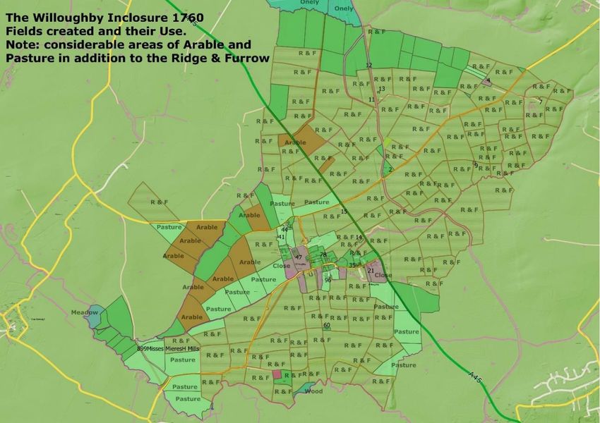
Willoughby NDP - First Draft Plan V6                                        September 26, 2018

2.0 A Neighbourhood Development Plan for Willoughby
                                         Map 1: Willoughby Neighbourhood Plan Area

2.1    Willoughby Parish Council decided to prepare a Neighbourhood Development Plan
       (NDP) for Willoughby Parish in August 2017 following a survey of residents in which
       the majority of respondents indicated they wanted an NDP.

2.2    The Parish Council applied to Rugby Borough Council for designation of the Parish as a
       ‘Neighbourhood Area’ and this was approved on 5 October 2017. The designated
       Neighbourhood Area is the same area as the Parish and is shown in Map 1 above.

2.3    The period covered by the Neighbourhood Plan is from 2018 to 2031. This
       corresponds to the final twelve years of the plan period for the emerging Rugby
       Borough Council Local Plan (2011 - 2031) and allows our Neighbourhood Plan to use
       the same evidence base as that plan.

                                                8
Willoughby NDP - First Draft Plan V6                                        September 26, 2018

2.4    A Steering Group of interested local residents and a parish councillor was set up in
       November 2017 to oversee the preparation of the Plan on behalf of the Parish Council.

2.5    Willoughby Parish Council has carried out two major surveys with local residents in the
       past six years. The first survey took place in September 2012 and informed the Parish
       Plan which was compiled in 2013 and updated in July 2015. The second survey took
       place in August 2014 and was preceded by a housing survey carried out by Midlands
       Rural Housing in June 2014. This information underpinned the Village Design
       Statement which was approved and adopted by Rugby Borough Council in August 2016
       and which is used by the Parish Council to help determine whether they should accept
       or object to planning applications submitted for the Parish.

2.6    The three surveys provided a great deal of information about the village and the views
       of the Willoughby community at the time. They covered the following areas:

       •   Surrounding Landscape
       •   Built Environment
       •   Housing and Planning
       •   Community Facilities and Services
       •   Traffic and Transport

2.7    It is important to note that the Parish Plan and the Village Design Statement
       considered both planning and non-planning matters. Many of the non-planning
       matters remain relevant and important to local residents but these cannot be
       addressed through the NDP, which is a planning policy document. However, the
       Parish Council is committed to tackling any non-planning issues wherever possible
       through other actions and processes.

2.8    The Steering Group considered the information in the Parish Plan and the Village
       Design Statement and these, together with their own considerable local knowledge,
       were used to prepare an Issues and Options document with the support of
       professional town planning consultants, Kirkwells. All information related to the NDP
       was provided on the Neighbourhood Plan pages of the Parish Council website
       https://www.willoughbyparishcouncil.org/neighbourhood-plan .

2.9    The Issues and Options full document was published for consultation with local
       residents and stakeholders from 7 May to 3 June 2018. A copy of the Summary Report
       and Questionnaire was delivered to all households in the parish and either delivered
       or posted to non-resident stakeholders. Consultees were also invited to complete the
       questionnaire online using https://www.surveymonkey.co.uk/r/WilloughbyNDP .

2.10   An initial Neighbourhood Development Plan Day was held on Wednesday, 16 May at
       the village hall. Residents were invited to come along and find out more about the
       NDP and receive help and support with the questionnaire, if required.

                                                9
Willoughby NDP - First Draft Plan V6                                        September 26, 2018

2.11   In total, 202 paper questionnaires were distributed and 112 completed forms were
       returned (54 online and 58 on paper). In addition, Historic England and Natural
       England provided supportive comments.

2.12   This First Draft NDP has been prepared taking into careful consideration the responses
       to the Issues and Options. In addition, the Steering Group has undertaken a significant
       amount of further detailed research over the summer to provide more detail for many
       of the policies and a sound evidence base. This information has been incorporated
       where possible into the supporting text and appendices of the Draft NDP. A detailed
       flood risk report can be viewed and downloaded from the NDP website.

2.13   The Neighbourhood Plan Steering Group would like to invite all local residents and
       stakeholders to consider this First Draft Plan document and to provide their comments
       and ideas.

2.14   All submitted representations will be considered carefully and used to inform the next
       step in the process – the finalisation of the Draft Neighbourhood Development Plan
       for Willoughby. The final Draft Plan will be published for formal consultation for 6
       weeks in late 2018 or early 2019.

                                               10
Willoughby NDP - First Draft Plan V6 September 26, 2018
3.0 Vision and Objectives
3.1 A Neighbourhood Development Plan is required to have a vision and a clear set of
objectives. The planning policies should then be designed to meet the identified
objectives.
3.2 In the consultation on Issues and Options 94.64% of respondents (106 responses) agreed
with the Draft Vision and 2.68% (3 responses) disagreed. There were a number of detailed
comments which have been considered and used to revise the wording.
DRAFT VISION
The attractive rural character of Willoughby village and the surrounding area will be
retained and enhanced. Development will take place in a gradual and sustainable way
to meet the needs of local people who live in or have a connection to the parish.
3.3 The responses to the Issues and Options consultation also demonstrated a high level of
support for the draft objectives, with 94.64% of respondents (106 responses) supporting
them and 2.68% (3) disagreeing. Again, detailed comments and suggestions have been
considered and used to inform revisions to the draft objectives.
DRAFT OBJECTIVES
Objective 1: To ensure that the rural landscape character of the parish is protected
and enhanced.
New development should be sustainable and should not detract from the character of
the existing structures and landscape. Landscaping schemes should be designed
sensitively taking into account the distinctive character of the historic agricultural
landscape and the surrounding countryside.
(This will be progressed through NDP policies W1, W2 and W3)
Objective 2: To conserve and enhance the built heritage assets in the parish.
New development should be designed to conserve and, where possible, to enhance
designated and non-designated built heritage assets and their settings.
(This will be progressed through NDP Policy W6)
11Willoughby NDP - First Draft Plan V6 September 26, 2018
Objective 3: To encourage high quality and sustainable design.
New development should demonstrate high quality, inclusive and sustainable design
and should positively contribute to the character and appearance of the area in which it
is sited.
(This will be progressed through NDP Policies W4, W5 and W7)
Objective 4: To provide a positive planning framework to guide the development of
new homes within the parish.
The development of new homes should respond positively to local needs. The scale,
location, size and type of any new homes should be sensitive to the rural area and take
into consideration the distinctive character of existing buildings.
(This will be progressed through NDP Policy W8)
Objective 5: To support home working and small businesses.
New businesses in the parish will be supported to help ensure Willoughby develops and
prospers. New businesses should be suitable for the countryside location and minimise
any adverse impacts on local residential amenity. New businesses which enable
agricultural diversification and rural enterprise will generally be supported.
(This will be progressed through NDP Policy W9)
Objective 6: To protect and improve local services and community and recreational
facilities.
Willoughby’s existing facilities will be protected and proposals for new facilities and
services will be encouraged.
(This will be progressed through NDP Policy W10)
12Willoughby NDP - First Draft Plan V6 September 26, 2018
4.0 NDP Draft Planning Policies
Entry to the village along Moor Lane
4.1 Introduction
4.1.1 Willoughby Parish is a small rural parish to the south-east of Rugby located between
Dunchurch and Daventry in the Leam Valley. Much of the parish is on the valley floor
but to the east beyond the A45 part of the land rises gently towards the
Northamptonshire village of Barby which is located upon a ridge of higher ground. The
A45 runs through the middle of the parish with the Oxford Canal running roughly
parallel a little further east. The village of Willoughby is bordered to the east by the
A45 and is surrounded by farmland, much of which is ancient ridge and furrow. In
2011, the population in the parish was 398 (Census, 2011).
4.1.2 This is a very rural area with a distinctive landscape character. The built character of
the village is a mixture of smaller houses and bungalows as well as larger properties.
These dwellings range from much older houses, one built in the 17th century, to some
houses built recently. Most houses are orientated to front the road and gable ends
facing the road are uncommon. Many of the houses are set back from the road and
sited within large, narrow plots which extend to the rear and provide open views to
the open countryside beyond. The village has a linear layout of single plots either side
of the through roads with four 'offshoot roads' where new housing development has
taken place over the years. The distinctive ‘valley floor’ character of the village is
13Willoughby NDP - First Draft Plan V6 September 26, 2018
enhanced by meandering street-side swales (ditches) and vegetation that provide
linking green corridors through the settlement.
4.1.3 The gradual growth of the village over the years has led to a built environment that is
generally harmonious and in keeping with the surrounding landscape. In the wider
parish there are a number of substantial farm houses and some more modest
dwellings.
4.1.4 The Neighbourhood Development Plan provides an opportunity to aim for high quality
in new development to ensure that change is integrated successfully and that our
environment is protected and enhanced.
14Willoughby NDP - First Draft Plan V6 September 26, 2018
4.2 Protecting and Enhancing our Rural Landscape
View over open countryside in Willoughby Parish
4.2.1 Willoughby village is set within a distinctive rural landscape. In the survey for the
Village Design Statement, 99% of villagers agreed that it was important to retain the
green area around Willoughby to keep it as a separate entity. The vast majority of
respondents (91%) thought that the agricultural land surrounding the village which
provides employment, important local character and views with pasture land, arable
crops, copses and hedgerows should be preserved at all costs. Almost everyone said
that all public footpaths and bridleways should be maintained and around 85%
believed that the views towards Barby, Braunston and Dunchurch should be
preserved.
Local Landscape Character
4.2.2 The landscape character of Willoughby Parish is described in the ‘Landscape
Assessment of the Borough of Rugby Sensitivity and Condition Study’ (April 2006)4.
Most of the Parish lies within the Feldon, Vale Farmlands landscape character type
(LCT). This LCT is described as:
‘an area of broad, flat, low-lying clay vales with few roads or settlements. It is
characterised by a largely intact pattern of medium to large-sized geometric fields,
bounded by hawthorn hedges. Tree cover of any kind is sparse, allowing wide views to
rising ground and giving a strong impression of sky and space. Despite a significant
4
https://apps.warwickshire.gov.uk/api/documents/WCCC-688-147
15Willoughby NDP - First Draft Plan V6 September 26, 2018
move towards arable production in recent years, extensive areas of permanent pasture
still remain a feature of this landscape, together with well-preserved areas of ridge and
furrow. Deserted medieval villages have also survived in places. Villages are typically
few and far between, often consisting of small, straggling clusters of farmsteads and
dwellings. Most are situated around a cross-road, and many are well off the beaten
track. Roads are often single track, with wide grass verges, bounded by a ditch and
thick hedge.’
4.2.3 The north-eastern part of the Parish rises to an area of Feldon, Ironstone Fringe
landscape character type. This LCT is described as: ‘a remote rural landscape
associated with a raised Lower Lias tableland which occurs along the fringe of the
Ironstone Wolds, (a hilly region in the western part of adjoining Northamptonshire). It
has a large scale, gently rolling topography, punctuated in places by prominent
ironstone hills. There are few roads or settlements, and sometimes there are extensive
areas of empty countryside, often associated with deserted medieval villages.
Large, isolated manor farmsteads are a feature of this area, together with small,
strongly nucleated ironstone villages often situated on rising ground. It is characterised
by a large, strongly hedged field pattern, which creates a relatively strong sense of
enclosure in an otherwise rather open, intensively farmed landscape with sparse tree
cover. Extensive areas of permanent pasture were a characteristic feature of the
Ironstone Fringe until relatively recently, much having been ploughed up. Where
pockets of pasture still remain, well-preserved ridge and furrow is often a special
feature. Roadside verges are typically wide and bounded by tall, thick hedgerows and
on steep hillsides, semi-natural grassland may sometimes be found.’
Examples of Ridge and Furrow from Moor Lane
4.2.4 The remaining areas of ridge and furrow landscape are of national importance and
should be protected from development, as should the pasture and arable fields of the
former enclosures. In English Heritage's Advice Report, 20115, which assessed the
moated site and an area of ridge and furrow for scheduling, it is noted that the
5
See NDP Additional Evidence on NDP website: English Heritage Advice Report, 23 September 2011, Case
Name: Moated Site 118, S of Manor Farm House and an area of ridge and furrow known as Big Grounds,
Willoughby
16Willoughby NDP - First Draft Plan V6 September 26, 2018
moated site and ridge and furrow are parts of the same medieval landscape of
Willoughby. The report goes on to explain that 'it is evident that the entire landscape
of ridge and furrow surrounding the modern village of Willoughby is of national
importance by virtue of its extent and the proportion of the medieval area under
plough which it represents'. The setting of these heritage assets is also significant and,
if development surrounds and encloses these areas, their value would be significantly
limited.
Landscape: The Historical Context
4.2.5 The settlement of Willoughby is an ancient one with 5 entries in the Domesday Book
of 1087 which reported ownership and use of land at the time of the Norman
conquest. The name is old Norse for willow farm suggesting it may have been a border
settlement between the Danelaw and Anglo-Saxon Mercia. One of the five Domesday
holdings had occupiers with Norse names, possibly raiders who settled.
4.2.6 Perhaps the most significant event, in terms of the development of the village, was the
grant in the 1100s by Henry I to Wigan the Marshal of various tranches of land
including a substantial proportion of our parish. Eventually in the 1200s, the last
member of Wigan’s family dying childless, this holding was given to the Hospital of St.
John the Baptist without the East Gate Oxford (the Hospital). This was a kind of
ecclesiastical hotel providing accommodation for travellers and sometimes the
destitute. The Hospital also received numerous other gifts of interests in land (shares
of rent, use of land etc) and bought land in the parish.
4.2.7 In 1458 William Waynflete, Bishop of Winchester and Lord Chancellor founded
Magdalen College and persuaded the King, Henry VI, to endow it with the former
estates of The Hospital including its land in Willoughby. The College were the largest
land owners until they sold the estate, mostly to sitting tenants, in the 1950s.
4.2.8 Until the 19th century the College leased the entire estate to a single lessee who
became the College’s agent. Their lease required them to accommodate the President
and an attendant twice a year when he would hold a Manorial Court and deal with
estate business. In later years the College let individual farms and properties and
managed them from Oxford. Over the years the College bought and sold land
gradually increasing the size of the estate. The College’s ownership of a large slice of
the parish has led to an extensive and fascinating archive of documents and court
records stretching back to 1230.
4.2.9 Farming practices changed markedly after the enclosure scheme in 1760. Prior to this
a large proportion of the land was ploughed. It is clear that land was ploughed before
Domesday which recorded that all 5 holdings had ploughed land. Later, the land was
farmed on the Medieval Open Field system until enclosure with a considerable
amount of land under plough creating the distinctive ridge and furrow profile. After
enclosure, farming practice changed and much of the land went to pasture and has
remained so. Hence the distinctive ridge and furrow visible across the Parish today.
17Willoughby NDP - First Draft Plan V6 September 26, 2018
4.2.10 A further impact of enclosure was that the new owners were required to plant hedges
and dig drainage ditches to enclose their allotted land. Most of these hedges remain
today to the benefit of wildlife (see Maps in Appendix 1). The change in agricultural
practice after enclosure, i.e. rearing stock rather than growing crops, resulted in a
significant reduction in the number of workers on the land and, as mechanisation took
hold, many of the traditional support services gradually disappeared e.g. wheelwright,
blacksmith.
Loss of our National Landscape Legacy
4.2.11 Between 1995 and 1999, Northamptonshire County Council and English Heritage
commissioned research into the survival of medieval open fields in the east Midlands.
This work was extended into the West Midlands including Warwickshire. The results of
the research have been published in a 2001 report: ‘Turning the Plough’. Midland open
fields: landscape character and proposals for management’. This confirmed that the
loss of these ridge and furrow landscapes across the Midlands was extreme.
4.2.12 ‘Turning the Plough’ recognised the national importance of the surviving ridge and
furrow in the parishes of Braunston (378ha) and Shuckburgh (372ha). Subsequently, it
emerged that the surviving ridge and furrow in Willoughby (388ha) was equally
important but had been omitted from the report. This was confirmed by the author
David Hall, the recognised authority on these landscapes. Analysis using Google Earth
aerial photography suggests that just 25% of the Parish’s ridge and furrow has been
lost to field consolidation over the years.
4.2.13 It should be noted that the land ownership, occupation and farming of these three
local parishes are closely linked over generations with those of Grandborough (and
Woolscott), Wolfhampcote (and Flecknoe) and Barby (and Onley), where connected
ridge and furrow is also found. Taken as a whole the landscape in this area of the
Upper Leam Valley is of great importance. Elsewhere significant loss of ridge and
furrow has continued e.g. the DIRFTIII and Rugby Radio Station developments have
caused the destruction of over 400ha nearby. It is notable that historic records relating
to Willoughby, in particular, and the other parishes are unusually extensive adding to
the historic value of the landscape.
Wildlife in the Landscape
4.2.14 This historic landscape of ancient ridge and furrow surrounded by mature hedges,
which have been in place for centuries, allows wildlife to flourish. Foxes, badgers, hares
and small mammals are often seen in the fields around the parish. The Oxford Canal
and the old Great Central railway also allow nature to thrive with ducks and swans
readily seen on the canal.
4.2.15 The village pond is home to many wild ducks and moorhens who breed here. It is also
used by frogs and frogspawn is evident in the spring. Visits are often made by a heron
and a kingfisher which feed on the fish. A brook runs through the village and the site of
the Moat (a scheduled monument) is home to wild ducks and a variety of nesting birds.
Hayward Lodge beside the A45 is a natural site where nature has been allowed to take
18Willoughby NDP - First Draft Plan V6 September 26, 2018
over and is home to rabbits and wild birds. There is a path running through the site
which enables people to enjoy the plants and wildlife.
4.2.16 Policy NE3: Landscape Protection and Enhancement in RBC’s emerging Local Plan
requires that ‘development proposals will be required to demonstrate that they …
consider its landscape context, including the local distinctiveness of the different
natural and historic landscapes and character, including tranquillity [and] relate well to
local topography and built form and enhance key landscape features ensuring their
long term management and maintenance’.
4.2.17 In the consultation on Issues and Options there was widespread support for including
a policy to protect local landscape character with 91.96% of respondents (103
responses) agreeing with such a policy and 5.36% (6) not agreeing.
4.2.18 In addition to comments noting strong agreement, there were a number of detailed
suggestions for changes. These included the need to protect the remaining areas of
ridge and furrow which are of national importance, the need to consider flooding and
flood risk in a new policy and proposed wording for a separate policy to protect locally
significant views. These suggestions have informed the changes to the policy wording
and supporting text.
4.2.19 Proposals for a new settlement on the edge of the parish at Lodge Farm have been
deleted from the Local Plan in the published Main Modifications. This was a highly
controversial scheme with a high level of objections from local residents and
stakeholders. Responses to the NDP Issues and Options consultation suggested that, if
the Lodge Farm Village allocation is reinstated at some point in the future, the green
gap between the southern boundary of Lodge Farm Village (2016 Publication Local
Plan Allocation DS10) and Willoughby village should be protected. Draft Policy W1
aims to support this by protecting green gaps generally between Willoughby village
and other settlements.
Draft Policy W1: Protecting and Enhancing Rural Landscape Character
Development proposals should be designed and sited to minimise any adverse visual
impacts on the local landscape character of Willoughby parish as described in the
Landscape Assessment of the Borough of Rugby Sensitivity and Condition Study (April
2006).
Proposals for new development should incorporate the following landscape design
principles:
A. The open, rural character of the landscape around Willoughby village should
be maintained. Isolated new residential buildings in the open countryside will
19Willoughby NDP - First Draft Plan V6 September 26, 2018
not be acceptable unless they meet the criteria of Rugby Local Plan Policy H4:
Rural Exceptions Sites or fall under permitted development.
B. Where possible, proposals for farming related development in the rural area
should adjoin the existing built form of farmsteads and other buildings. Large
new agricultural buildings and structures should be sited and designed
sensitively to avoid breaking the skyline in terms of views from Willoughby
village, and landscaping schemes should incorporate screening using native
species in hedgerows (see Policy W4) and locally appropriate materials in walls
and fences. Larger buildings should be ‘broken up’ using a change in materials
or colour or a break in the roof line.
C. The sensitive conservation and restoration of traditional farm buildings
through continued and appropriate new uses is supported. Repairs and
alterations should use local materials and techniques wherever possible.
D. Steps should be taken to preserve and enhance wildlife habitats, green and
blue infrastructure corridors and heritage assets such as historic field patterns,
hedgerow field boundaries and drainage ditches.
E. The remaining areas of ridge and furrow landscape and pasture/arable fields
of former enclosures as identified on the maps in Appendix 1 are of national
importance and development which impacts adversely on these areas and
their setting will be strongly resisted.
F. The green gaps between Willoughby Village and all other hamlets and villages
(existing or proposed) should be protected to prevent coalescence of
settlements and to ensure that the settlement of Willoughby village remains
distinct.
G. Lighting schemes should be designed to minimise light pollution. Security
lighting should be appropriate, unobtrusive and energy efficient and have
consideration for neighbouring amenity.
H. Development within Willoughby village should protect important local
landscape features which enhance the character of the built-up area and link
it to the open countryside. These include the following: existing grass verges,
hedges, trees, wild areas, swales and ponds. New developments should aim to
incorporate these features into landscaping designs.
20Willoughby NDP - First Draft Plan V6 September 26, 2018
Protecting Locally Significant Views
4.2.20 In the consultation for the Village Design Statement in 2014, local people were asked to
indicate whether or not specific views should be protected. These were Views 1, 2, 3, 5, 6
and 7 on the maps below. Almost 85% of respondents said that they should be protected.
4.2.21 During the Issues & Options consultation for the NDP in May/June 2018, local residents
were asked again about these views and to indicate how important they were on a scale of
1 (not important at all) to 5 (very important). All were felt to be important. Percentages for
4 and 5 on the scale were added together to find out the level of strong support. Views 6
and 7 (towards Dunchurch and Braunston) - 72%, views 2 and 3 (towards Barby) - 78.57%
and views 1 and 5 towards the village from Woolscott Road and Longdown Lane - 84%.
4.2.22 As part of the preparation for the Issues & Options consultation, the Steering Group
decided that a view that was significant to them should be added to find out how
important it was to other local people. This was View 9 (from Moor Lane towards
Grandborough). 83% of respondents scored this view at 4 or 5 on the scale.
4.2.23 During the Issues and Options consultation, respondents were asked to make suggestions
for other views that were important to them. The two most suggested views by far were
View 4 (from Moor Lane towards the Church) and View 8 (from Moor Lane south across Big
Ground towards Sawbridge). Both these views hold special significance for local people.
The Church is highly valued as a centuries-old listed building and village landmark and the
field from Moor Lane provides an important part of its setting. View 8 looks across Big
Ground which now holds iconic status as the site where local people successfully fought
against a planning application to build a crematorium in 2011. As a result, these two views
have been added to the First Draft NDP to find out if they are supported more generally by
local people as significant views.
Map 2A: Significant Views in Willoughby Village
21Willoughby NDP - First Draft Plan V6 September 26, 2018
1. View from Woolscott Road looking south along 2. View from PROW 247c6 looking north-east
Lower Street towards the village towards Barby Hill. The Old Vicarage is on the
left.
3. View from the village playing field looking 4. View from Moor Lane looking north-west
north-east towards Barby Hill towards the church
6
PROW 247c is the public footpath from Lower Street that goes behind the village houses as a shortcut to the
playing field and the Rose Inn.
22Willoughby NDP - First Draft Plan V6 September 26, 2018
Map 2B: Significant Views in Willoughby Parish
5. View from Longdown Lane looking south-west 6. View from Woolscott Road (right of the Cricket
towards the village and Flecknoe on the hill in the Club) looking north-west towards Dunchurch
distance
23Willoughby NDP - First Draft Plan V6 September 26, 2018
7. View from Woolscott Road looking south-east 8. View from Moor Lane looking south-west across
towards Braunston. The church spire is in the Big Ground towards Sawbridge.
middle in the distance.
9. View from Moor Lane looking west towards
Grandborough. The church spire is on the right in
the distance.
Draft Policy W2: Protecting Significant Local Views
The identified Significant Views on Maps 2A and 2B make an important contribution
towards local visual amenity and the neighbourhood area’s landscape character.
Development proposals should respect these Significant Views which are locally
valued. Where a development proposal impacts on an identified Significant View,
a Landscape and Visual Impact Assessment or similar study should be carried out
to ensure that the scheme is designed and sited sensitively and appropriately to
mitigate any adverse impacts.
24Willoughby NDP - First Draft Plan V6 September 26, 2018
Community Led Renewable Energy Schemes
4.2.24 The consultation on Issues and Options included a question about whether the NDP
should support proposals that come forward over the plan period for community based
renewable energy schemes. The responses from consultees suggested an ambivalence
about this issue, with 44.64% (50) agreeing that the NDP should include such a policy,
46.43% (52) not agreeing, and 8.93% (10) not answering.
4.2.25 The NDP Steering Group agreed that such a policy should be included in the Draft NDP,
provided that there is a clear cross-reference to Draft Policy W1 which protects local
landscape character. It was suggested that a Draft Policy could be tested further
during the consultation on the First Draft Plan.
4.2.26 NDPs are required to promote sustainable development and there is an increasingly
pressing need for policies and plans to contribute towards energy efficiency and
carbon reduction measures to address climate change. Small scale community led
renewable energy schemes can help to improve security of energy supply and often
provide an income stream to support other community projects. Examples of
community energy projects include:
• Community-owned renewable electricity installations such as solar photovoltaic
(PV) panels or hydroelectric generation.
• Members of the community jointly switching to a renewable heat source such as a
heat pump or biomass boiler.7
4.2.27 The NPPF para 151. sets out that Local planning authorities should support community-
led initiatives for renewable and low carbon energy, including developments outside
areas identified in local or strategic plans that are being taken forward through
neighbourhood planning. Rugby's emerging Local Plan Policy SDC8: Supporting the
provision of renewable energy and low carbon technology supports proposals for new
low carbon and renewable energy technologies subject to criteria including requiring
that designs minimise the adverse impacts (including any cumulative impacts) on the
natural environment in terms of landscape, and ecology and visual impact.
4.2.28 NDP Draft Policy W3 has been prepared to help guide proposals for community based
renewable energy schemes, should any such projects come forward over the plan period.
Draft Policy W3: Community-Led Renewable Energy Schemes
Community-led initiatives for renewable and low carbon energy schemes will be
supported, provided that any adverse landscape and visual impacts (including
cumulative impacts) are mitigated and, where this is not possible, minimised.
7
See Community Energy
A guide aimed at local groups who are interested in setting up a community energy project.
https://www.gov.uk/guidance/community-energy#what-is-community-energy
25Willoughby NDP - First Draft Plan V6 September 26, 2018
4.3 Local Green and Blue Infrastructure
Oxford Canal bridge by Navigation Cottage and View towards Braunston
4.3.1 Green Infrastructure (GI) is ‘a network of multi-functional green space, urban and
rural, which is capable of delivering a wide range of environmental and quality of life
benefits for local communities' (NPPF Annex 2 Glossary). These networks include water
courses, ponds and canals which are commonly also referred to as ‘blue
infrastructure’.
4.3.2 Rugby Borough Council (RBC) Green Infrastructure Study, Final Report June 20098
suggests that the following resources should, wherever possible, be incorporated
within local GI networks:
• hedgerows, rail and motorway embankments and road verges that provide
movement corridors and habitats for a range of wildlife (including legally protected
and other notable species);
● notable species populations;
● woodlands, orchards and trees that play an important role in providing shading and
contributing to the image of an area (as well as being valuable habitats);
● areas of historic value at the local scale (HER records and Historic Landscape
Characterisation); areas of high landscape quality (identified through landscape
character assessments);
● landscape, ecological and historic features that contribute to local character and
sense of place;
● ponds, which provide valuable wildlife habitats and may have a role in local
drainage networks;
● public rights of way and permissive routes that may be important as sustainable
movement corridors; and
● allotments.
8
https://www.rugby.gov.uk/downloads/file/197/green_infrastructure_study
26Willoughby NDP - First Draft Plan V6 September 26, 2018
4.3.3 RBC’s emerging Local Plan Policy NE2: Strategic Green and Blue Infrastructure sets out
that the Council will work with partners towards the creation of a comprehensive
Borough wide Strategic Green and Blue Infrastructure Network.
4.3.4 The Draft NDP identifies locally relevant Green Infrastructure (GI) networks which are
found in the Willoughby neighbourhood area. The responses to the Issues and Options
consultation showed that 92.86% of respondents (104 responses) supported the inclusion
of a GI policy in the NDP with only 2.68% (3) not supporting such a policy. Draft Policy W4
aims to protect local GI and encourages new development to enhance these networks.
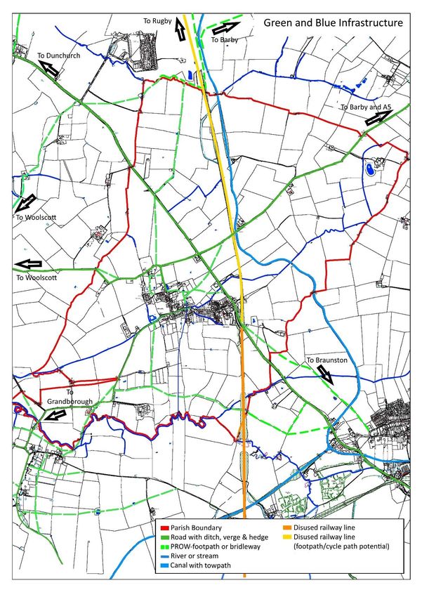
4.3.5 Map 3 shows the Blue and Green Infrastructure networks identified in Willoughby.
Draft Policy W4: Green and Blue Infrastructure in Willoughby
Green and Blue Infrastructure networks in Willoughby parish are identified on Map
3. These networks support biodiversity, contribute towards reducing flood risk
and improving water quality management and enhance the landscape and historic
character of Willoughby Parish.
A. New development should protect and where possible enhance existing Green
and Blue Infrastructure. Development which delivers the creation of new
multifunctional green and blue infrastructure will be supported.
B. Proposals should demonstrate how existing networks within the site will be
maintained in perpetuity.
C. Opportunities should be taken to extend existing networks of footpaths,
bridleways and cycleways. Wherever possible, these networks should be
linked to other green corridors, neighbouring amenities and communities to
increase their environmental and quality of life benefits.
D. Development should incorporate mitigation measures to protect and enhance
the river corridors of the River Leam and its tributaries and the swales which
flow through the centre of the village of Willoughby. Opportunities should be
taken to open up culverted watercourses wherever possible.
E. New planting and landscaping schemes should use locally appropriate species
which contribute to biodiversity and wildlife objectives.
27Willoughby NDP - First Draft Plan V6 September 26, 2018
Map 3: Green and Blue Infrastructure in Willoughby Parish
28Willoughby NDP - First Draft Plan V6 September 26, 2018
Reducing Flood Risk
4.3.6 A significant area of Willoughby village is at risk of flooding. A watercourse (Willoughby
Brook) flows through the heart of the village, and whilst it provides visual interest and
supports local wildlife, there is a risk of fluvial flooding as shown on Map 4 and surface
water flooding as shown on Map 5.
Map 4: Flood Map for Planning, Willoughby Village (Fluvial Flooding)9
Map 5: Surface Water Flooding (Environment Agency Flood Map)
9
https://flood-map-for-planning.service.gov.uk/
29Willoughby NDP - First Draft Plan V6 September 26, 2018
4.3.7 The Flood Risk Report 2018 (see Additional Evidence on NDP website) provides more
detail about fluvial, surface water and groundwater flooding in Willoughby. Surface water
flooding occurs when rainfall is unable to soak into the ground or enter the drainage
system and creates runoff which flows over the surface to low lying areas. It is usually the
result of intense rainfall, often of short duration, (typically, greater than 30-40 mm /hr).
Whilst surface water flooding is basically driven by the topography of the land, and
permeability of the subsoils, it is influenced to a significant degree by man-made
structures, bridges, culverts, fences and other development, especially that associated
with significant areas of hard standing.
4.3.8 The most significantly affected point in the village during any flooding episode is the
junction of Main Street and Lower Street, where the brook passes under Main Street via
two culverts. As the water level downstream rises the brook backs up to top its bank. The
water level in the brook rises until the occupation bridge at the end of the footpath along
Moor Lane is submerged. The flooding here is often made worse by large cars driving at
speed through the flood and throwing the water up against the houses which front
directly onto the road.
4.3.9 Poorly maintained drainage ditches can also contribute to flooding in the area. The Parish
Council will work to encourage landowners in the parish to maintain drainage ditches on
private land, and to keep them clear of debris to maximise capacity and reduce risk of
overflowing.
4.3.10 Emerging Rugby Local Plan Policy SDC5: Flood Risk Management sets out that a sequential
approach to the location of suitable development will be undertaken by the Council based
on the Environment Agency’s flood zones as shown on the latest Flood Map for Planning
and Strategic Flood Risk Assessment (SFRA). This will steer new development to areas with
the lowest probability of flooding, in order to minimise the flood risk to people and
property and manage any residual risk.
Draft Policy W5: Reducing Flood Risk in Willoughby
A. In areas where fluvial10 or surface water flood risk is a known issue, proposals
will be resisted unless suitable mitigation can be provided which does not
exacerbate run off elsewhere. Wherever possible, development proposals
should seek to provide a betterment.
B. Development proposals will be required to provide effective surface water
drainage measures to protect existing and future residential areas from
flooding. New development should be designed to maximise the retention of
surface water on the development site and to minimise runoff.
C. Sustainable drainage systems (SuDS) should be implemented in accordance
with the SuDS hierarchy unless deemed inappropriate.
10
From rivers or other watercourses.
30Willoughby NDP - First Draft Plan V6 September 26, 2018
4.4 Conserving and Enhancing our Built Heritage Assets
Church of St. Nicholas (Grade II*)
4.4.1 Three historic transport routes run through Willoughby Parish. The village itself lies on an
important historic road from London to Holyhead. In 1790, the Oxford Canal was opened
with a wharf near Willoughby and this remains an important leisure route today. Later,
the Great Central Railway station opened in 1899 (closed 1957) providing a regular rail
service to London.
4.4.2 The street plan of the village has remained largely unchanged for centuries. The
upper part of Main Street, Lower Street, Moor Lane and Woolscott Road were farm tracks
until the 1920s. Much of the housing was of traditional cob and thatch until the 1920s
when many were condemned as unfit for human habitation and demolished to be
replaced by brick and tile houses.
4.4.3 Willoughby’s built heritage and distinctive character are clearly valued locally as positive
assets. In the questionnaires for the Parish Plan and for the Village Design Statement, a
considerable majority of respondents wanted the heritage of the village to be protected
and many people noted buildings which were of visual or historical importance to them.
4.4.4 The responses to the Issues and Options consultation demonstrated strong support for
the NDP to include a planning policy to protect and enhance built heritage assets in the
parish. 87.50% of respondents (98 responses) supported such a policy and 5.36% (6) did
not. Comments included the need to protect ridge and furrow landscapes (this is
addressed in Draft Policy W1), that new products can enhance and blend in and that there
is a need for new development to be in keeping with the existing village.
31Willoughby NDP - First Draft Plan V6 September 26, 2018
4.4.5 Many of the oldest built heritage assets in the village are in the historic core. These
include:
Lower Street with its terraced cottages and detached properties such as Barrowfield and
Church View, which used to have a Methodist chapel at the end of the building. Vale
House, a timber-framed house next door was built in the the 17th century.
Main Street where older properties include The Bakehouse and Post Cottage, together
with buildings near the village sign triangle such as the Rose Inn, The Old School House,
The White House and The Willows.
4.4.6 Other more scattered historic properties include Bath Farm in Moor Lane, The Old
Vicarage off Lower Street and Gate Farm on the A45, together with Manor Farmhouse
near to St Nicholas’ Church. Willoughby House on the Sawbridge Road was built in the
1860s on the site of The Bath Hotel which was a spa during the first half of the 19th
century. The site of a moated farmstead dated to the 1400s in Moor Lane is designated a
scheduled monument by English Heritage. In total, there are six listed buildings in the
Parish including the Grade II* listed Church of St Nicholas and one scheduled monument,
The Moat. These are:
• The Smithy (Grade II)
• The Rose Public House (Grade II)
• Vale House (Grade II)
• Church of St Nicholas (Grade II*)
• Manor Farmhouse (Grade II)
• Whitehouse Farmhouse (Grade II) and
• Moated Site south of Manor Farmhouse (Scheduled).
4.4.7 Appendix 2 provides more information about the statutory Listed Buildings in the parish.
4.4.8 Appendix 3 identifies and describes proposed non-designated heritage assets for further
consideration by Rugby Borough Council. These are:
• Cottage Farm
• Pye Court
• The Old Vicarage
• Gate Farm
• Navigation House (Inn) and Cottage
• Old Station Master’s House
• Willoughby House
• Ivy House Farm
• Church View
• Barrowfield
• Red House
• Lower Street Cottages
• Bath Farm
• Post Cottage
32Willoughby NDP - First Draft Plan V6 September 26, 2018
• The Bakehouse
• The Old School House
• The Willows
• College Farm
• The Wesleyan Chapel
• Four Crosses
Manor Farmhouse (Grade II)
4.4.9 Rugby Borough Council’s emerging Draft Local Plan Policy SDC3: Protecting and
Enhancing the Historic Environment supports development which sustains and
enhances the significance of the Borough’s heritage assets including listed buildings,
conservation areas, historic parks and gardens, archaeology, historic landscapes and
townscapes. The NPPF defines Heritage Assets as ‘A building, monument, site, place,
area or landscape identified as having a degree of significance meriting consideration
in planning decisions, because of its heritage interest. It includes designated heritage
assets and assets identified by the local planning authority (including local listing).'
4.4.10 Draft Policy W6 seeks to conserve and enhance the historic environment of Willoughby,
taking into account locally important heritage assets and significant features.
33Willoughby NDP - First Draft Plan V6 September 26, 2018
Draft Policy W6: Conserving and Enhancing Built Heritage Assets and
their Settings
Development proposals should conserve and enhance built heritage assets in
Willoughby, including any locally significant, non-designated heritage assets.
Wherever possible, the following criteria should be addressed:
A. Development proposals including alterations to existing buildings should
describe the significance of any heritage assets affected, including any
contribution made by their setting, and conserve and enhance assets
according to their significance.
B. All development should seek to conserve both designated and non-designated
heritage assets including listed buildings and locally significant non-designated
assets identified in this Neighbourhood Development Plan for consideration
by Rugby Borough Council (see Appendix 3), and put in place measures to
avoid or minimise impact or mitigate damage.
C. Development proposals in areas on maps in the Warwickshire Historic
Environment Record (HER) for Willoughby Parish must take account of known
surface and subsurface archaeology and ensure unknown and potentially
significant deposits are identified and appropriately considered during
development. In all instances the Warwickshire Historic Environment Record
should be consulted at an early stage in the formulation of proposals.
34Willoughby NDP - First Draft Plan V6 September 26, 2018
4.5 Encouraging High Quality and Sustainable Design
Manor Farm Barns - brick-built agricultural barns
converted to eight houses in 1999
4.5.1 At the same time as conserving and enhancing built heritage assets in Willoughby, the
Parish Council recognises that, where appropriate, the NDP should support high quality
contemporary designs in new development in the village and the wider rural area of the
parish. This approach was supported by local residents in the consultation on Issues and
Options, with 92.86% of responses (104) supporting such a policy in the NDP and 4.46% of
responses (5) not supporting the inclusion of a policy promoting high quality design.
Various suggestions were made for improving the policy wording such as incorporating
more detail in relation to sustainable design and these have been incorporated wherever
possible into the Draft Policy.
4.5.2 Around the village, some of the traditional buildings are built of stone and Vale House is
timber-framed, but most buildings are constructed from red brick while some have a
rendered finish or are painted white. Buildings are generally modest in scale (mainly one,
one and a half or two storeys) but there are some larger detached houses, both
traditional and modern. All roofs are sloping and are a mixture of slate and clay tiles or
curved, concrete tiles. The only building left in the village with a thatched roof is the Rose
Inn. As new development takes place, the village and wider parish will continue to evolve
and the Plan could encourage appropriate contemporary responses to the more
traditional buildings which currently exist.
4.5.3 As part of the background evidence for the Neighbourhood Development Plan, the
Steering Group has prepared local character appraisals of distinct areas around the village
35You can also read