Wiltshire Local Plan Transport Review - Wiltshire Council
←
→
Page content transcription
If your browser does not render page correctly, please read the page content below
Wiltshire Local Plan
Transport Review
Wiltshire Council
January 2021
Notice
This document and its contents have been prepared and are intended solely as information for Wiltshire
Council and use in relation to reporting on the findings of the transport planning support for the Wiltshire Local
Plan.
Atkins Limited assumes no responsibility to any other party in respect of or arising out of or in connection with
this document and/or its contents.
This document has 64 pages including the cover.

Document history
Document title: Transport Review
Document reference: Wiltshire Local Plan
 Revision Purpose description Originated Checked Reviewed Authorised Date
 Rev A Final Various PK JFC JFC Jan 2021

Client signoff
 Client Wiltshire Council
 Project Wiltshire Local Plan
 Job number 5195979
 Client
 signature/date

Wiltshire Local Plan | A | January 2021
Atkins | Wiltshire Local Plan Transport Review - for issue Jan 2021 Page 2 of 64
Contents
Chapter Page
1. Introduction 6
1.1. Scope of assessment 6
1.2. Model review and refinements of the Wiltshire model 6
1.3. Forecast scenarios 6
2. Assessing impacts of Local Plan growth 8
2.1. Model scenario definitions 8
2.2. Forecasting highway demand for each scenario 8
2.3. Do-Nothing and Do-Minimum infrastructure assumptions 9
2.4. Assessing the impacts of Local Plan growth (Do-Minimum vs Do-Nothing) 13
3. Mitigating impacts of Local Plan growth 17
3.1. Approach to identification of the mitigation package 17
3.2. Walking and cycling mitigation measures 17
3.3. Public transport mitigation measures 19
3.4. Highway mitigation measures 23
3.5. Assessing the performance of the combined mitigation package 25
4. Conclusions and Summary 30
4.1. Impacts of Local Plan growth without mitigation 30
4.2. Proposed mitigation 30
4.3. Impacts of mitigation 32
4.4. Next steps 32

Appendices 33
 Guiding principles and hierarchy of interventions 34
A.1. Defining ‘severe impacts’ 34
A.2. Principles for identifying mitigation schemes 35
 Assumptions used in testing 38
B.1. Chippenham site options 41
B.2. Trowbridge site options 41
B.3. Salisbury site options 41
 Additional Considerations 42
C.1. Wiltshire modal share 42
C.2. Parking policy recommendations 42
 Highway scheme designs 43
D.1. Melksham Bypass (SOBC) 44
D.2. A350 Phase 4&5 Dualling (SOBC) 45
D.3. M4 Junction 17 (SOBC) 46
D.4. Salisbury Junctions (SOBC) 47
D.5. Staverton bridge bypass 49
 Methodology to assess active travel impacts 50
E.1. Methodology to assess impacts 50
E.2. Findings 51
 Methodology for estimation of rail and bus patronage 52
F.1. Current rail patronage 52

Wiltshire Local Plan | A | January 2021
Atkins | Wiltshire Local Plan Transport Review - for issue Jan 2021 Page 3 of 64
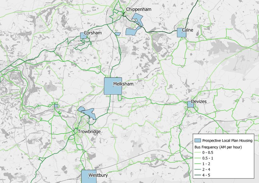
F.2. Station accessibility 52
F.3. Estimated potential rail demand with prospective Local Plan 53
F.4. Current bus provision and services 55
 Estimated scheme costs 58
G.1. Estimated cost of proposed walking and cycling measures 58
G.2. Estimated cost of public transport measures 58
G.3. Estimated highway scheme costs 59
 Economic Appraisal 61
H.1. Economic appraisal of combined mitigation package 61
H.2. Value for Money 63

Tables
Table 1-1 - Summary of household forecasts 7
Table 2-1 - Model scenario definitions and assumptions 8
Table 2-2 - Development trip rates per hour (derived from TRICS) 9
Table 3-1 - Chippenham and Trowbridge public transport improvements 22
Table A-1 - Defining severe impacts through V/C ratio 34
Table A-2 - Proposed hierarchy of interventions 36
Table C-1 - Estimated travel modal share in Wiltshire (2018) 42
Table E-1 - Calculation of derived all-purpose trips cycle mode share (Chippenham example) 50
Table E-2 - Calculation of all-purpose cycle mode split post-scheme (Chippenham example) 51
Table E-3 - Expected impact of active travel measures on highway demand 51
Table F-1 - Journey time comparison by mode between main railway stations (station to station)53
Table F-2 - Proportion of population within distance bands from a railway station 53
Table F-3 - Estimated car trips generated by prospective Local Plan housing by town 54
Table F-4 - Estimated total person trips generated by prospective Local Plan housing by town 54
Table F-5 - Estimated additional rail passengers by town 54
Table F-6 - Wiltshire bus service punctuality (by percentage) 57
Table G-1 - Estimated cost of active travel mitigation measures (2020 prices and values) 58
Table G-2 - Indicative bus capital and revenue costs (2020 prices and values) 58
Table G-3 - High-level cost assumptions for Local Plan highway schemes 59
Table G-4 - Estimated Local Plan highway scheme costs 60
Table H-1 - Estimated combined cost of MRN schemes 62
Table H-2 - Estimated combined cost of Local Plan mitigation package 62
Table H-3 - Standard DfT Value for Money (VfM) categories 63
Table H-4 - Value for Money statement (PVC 2010 prices and values, millions) 63

Wiltshire Local Plan | A | January 2021
Atkins | Wiltshire Local Plan Transport Review - for issue Jan 2021 Page 4 of 64
Figures
Figure 2-1 - Impacts of Local Plan forecast growth to 2036 11
Figure 2-2 - The need for a Southern Distributor Road (SDR) 12
Figure 2-3 - Changes in traffic flows from Local Plan growth to 2036 on the A350 corridor 13
Figure 2-4 - Changes in traffic flows from Local Plan growth to 2036 in Salisbury and Amesbury14
Figure 2-5 - Impacts of forecast Local Plan growth on the A350 corridor 15
Figure 2-6 - Impacts of forecast Local Plan growth in Salisbury and Amesbury 16
Figure 3-1 - Chippenham new walking and cycling infrastructure 17
Figure 3-2 - Trowbridge new walking and cycling infrastructure 18
Figure 3-3 - Salisbury new walking and cycling infrastructure 18
Figure 3-4 - Bus corridors to support Local Plan growth: Chippenham 20
Figure 3-5 - Bus corridors to support Local Plan growth: Trowbridge 21
Figure 3-6 - Schemes already developed as improvements to the Major Road Network (MRN) and further
interventions to mitigate Local Plan growth 24
Figure 3-7 - Changes in traffic flows with suggested combined mitigation on the A350 corridor 25
Figure 3-8 - Changes in traffic flows with suggested combined mitigation in Salisbury and Amesbury 26
Figure 3-9 - Impacts of mitigation on the A350 corridor 27
Figure 3-10 - Impacts of mitigation in Salisbury and Amesbury 28
Figure A-1 - Process for identification of severe impacts 35
Figure B-1 - Chippenham: housing sites and schemes in uncertainty log 38
Figure B-2 - Trowbridge: housing sites and schemes in uncertainty log 39
Figure B-3 - Salisbury: housing sites and schemes in uncertainty log 40
Figure F-1 - Patronage at rail stations in Swindon and Wiltshire 52
Figure F-2 - West Wiltshire bus routes by frequency 55
Figure F-3 - South Wiltshire bus routes by frequency 56

Wiltshire Local Plan | A | January 2021
Atkins | Wiltshire Local Plan Transport Review - for issue Jan 2021 Page 5 of 64
1. Introduction
1.1. Scope of assessment
Wiltshire Council is undertaking a Local Plan Review. The Council commissioned Atkins to provide transport
planning support for the review process, using Wiltshire’s strategic transport model. This included:
• Review of the Wiltshire strategic model to ensure that it accurately reflects existing (2018) traffic conditions
 on the road network;
• Development of forecast scenarios to reflect future development and planned transport improvement
 schemes;
• Analysis of the impacts of prospective Local Plan growth on the road network;
• Initial assessment of the scope to improve active travel and public transport to enhance travel choices; and
• Development of options for mitigation of the impacts on the road network.

1.2. Model review and refinements of the Wiltshire model
The Wiltshire strategic model was reviewed to confirm the model’s capability and robustness throughout the
process. This review focussed on ensuring that the transport networks in the settlements subject to detailed
assessment (Chippenham, Salisbury and Trowbridge) accurately reflect actual base 2018 conditions.
High-level sense checks were also undertaken for Wiltshire’s market towns; these reviewed the level of network
coding detail and zoning structures for each town.
The Wiltshire strategic model is based on a 2018 base year. Forecasts of future travel demand were developed
based on standard DfT modelling assumptions, together with specific forecasts of housing and employment
growth (see section 1.3 below). However, the COVID-19 pandemic has caused unprecedented levels of
disruption to the economy and the ways in which people travel since March 2020. The long-term impacts of the
pandemic are likely to cause potentially significant changes in travel demand and behaviour, which are
currently impossible to predict. The analyses are therefore based on 2018 base year data and (unadjusted)
forecasts of demand to 2036. It is recommended that future analysis includes scenario testing to assess the
potential implications of future changes in travel behaviour that could emerge following the pandemic.

1.3. Forecast scenarios
Wiltshire Council provided a list of planned developments and infrastructure associated with the existing
Wiltshire Core Strategy (January 2015) and subsequent site allocation plans 1. The following scenarios formed
the basis of testing:
• Do Nothing:
 • includes all Wiltshire Core Strategy growth and infrastructure; and
 • excludes post Wiltshire Core Strategy growth and associated infrastructure (see Table 2-1);
• Do Minimum (Do Nothing with prospective Local Plan growth and minimal access infrastructure (see Table
 2-1); and
• Do Something (Do Minimum with prospective Local Plan growth plus transport mitigation measures (See
 section 3).
A summary of household forecasts for these demand scenarios is shown in Table 1-1. The household totals for
each scenario in Wiltshire are as follows:
• 2018 Base: ~208,000 households;
• 2036 Do Nothing: ~228,000 (~20,000 additional households); and
• 2036 Do Minimum: ~246,000 (~A further 18,000 additional households, to be tested for the prospective
 Local Plan).

1 Chippenham Site Allocations Plan (May 2017) and Wiltshire Housing Site Allocations Plan (February 2020).

Wiltshire Local Plan | A | January 2021
Atkins | Wiltshire Local Plan Transport Review - for issue Jan 2021 Page 6 of 64
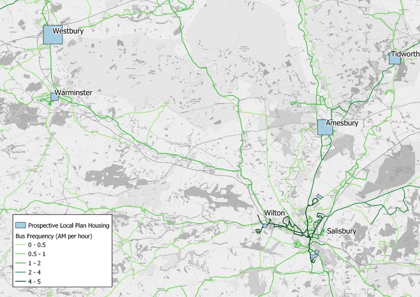
Table 1-1 - Summary of household forecasts
 2036 Do
 Base 2018 2036 Do Minimum and Do
 HMA Region Region Nothing)
 (Households) Something
 (Note 2) (Notes 3,4)

 Chippenham 15,452 18,439 23,539
 Corsham 2,700 2,870 3,060
 Melksham 8,618 9,814 12,489
 Chippenham HMA Calne 8,379 8,998 9,418
 Devizes 6,416 6,759 7,004
 Malmesbury 8,772 9,122 9,122
 Rest of HMA 13,109 13,284 14,754
 Tidworth/ Ludgershall
 Amesbury
 Salisbury HMA 64,389 72,208 74,923
 Salisbury
 Rest of HMA
 Trowbridge 17,418 21,018 22,818
 Westbury 7,385 8,240 9,365
 Trowbridge HMA Warminster 8,058 9,778 10,038
 Bradford on Avon
 30,241 30,391 31,051
 Rest of HMA
 Royal Wootton
 Bassett 6,059 6,059 7,085
 West of
 Swindon Marlborough
 HMA 10,576 10,576 11,179
 Rest of HMA
 Wiltshire 207,572 227,556 245,845

 1. An Uncertainty Log was used to project the locations of housing included in the current core model. It
 shows the numbers of forecast dwellings. For the purposes of this analysis, one dwelling is assumed
 to be equivalent to one household.
 2. 2036 Do Nothing (including Core Strategy growth in Uncertainty Log and excluding prospective Local
 Plan + Base 2018).
 3. Estimates for Local Plan housing derived from housing figures in Appendix B provided by Wiltshire
 Council. This shows the number of proposed dwellings. For the purposes of this testing, one dwelling
 is assumed to be equivalent to one household.
 4. Note that this forecast has a higher household trajectory than the 2036 National Trip End Model
 (NTEM) Core forecasts used by the Department for Transport.

Wiltshire Local Plan | A | January 2021
Atkins | Wiltshire Local Plan Transport Review - for issue Jan 2021 Page 7 of 64
2. Assessing impacts of Local Plan growth
2.1. Model scenario definitions
The model scenario definitions and assumptions are presented in Table 2-1. The demand assumptions are
based on the housing forecasts presented in Table 1-1 and are detailed in section 2.2. The infrastructure
assumptions are based on an uncertainty log2, which was developed in accordance with TAG3. Further detail is
provided in section 2.3.

Table 2-1 - Model scenario definitions and assumptions
 Scenario Demand assumptions (section 2.2) Infrastructure assumptions (section 2.3)
 2036 Do- Wiltshire Core Strategy growth Base + Core infrastructure (as defined in the
 Nothing excluding prospective Local Plan growth. Uncertainty Log used for modelling).

 2036 Do- Do Nothing with prospective Local Plan Do-Nothing + Local Plan site-specific
 Minimum growth. access.
 Location-specific sites use TRICS trip rates Assumes improvements to A350 Lackham
 (see Table 2-2). and Bumpers Roundabouts and the new
 “Rest of Housing Market Area” (see section Chippenham Eastern and Southern
 1.2) trips use background NTEM trip rates. Distributor Roads (See section 2.3.1).

 2036 Do - Do Minimum - prospective Local Plan Do-Minimum + schemes already developed
 Something growth minus the effect on demand of as improvements to the Major Road Network
 transport mitigation measures for walking, (MRN) and further interventions to mitigate
 cycling & public transport (see section 3). Local Plan growth (see Figure 3-6).

2.2. Forecasting highway demand for each scenario
In order to test the impacts of the prospective Local Plan growth and determine suitable mitigation measures
the following steps were undertaken to derive highway demand for the model scenarios defined above.
• The housing numbers assumed for each scenario are defined in section 1.3 and summarised in Table 1-1.
• In the Do Nothing (DN) scenario, the housing and growth assumptions assume only committed housing
 and infrastructure identified within the Wiltshire Core Strategy and Local Transport Plan. The existing
 strategic model was reviewed. This used the existing forecast model and revised the level of overall
 housing (using alternate assumptions within DfT’s National Trip End Model, NTEM) to forecast the
 expected number of overall trips.
• The Do Minimum (DM) scenarios include the prospective Local Plan growth. Housing locations were
 provided by Wiltshire Council for the Principal Settlements (Chippenham, Trowbridge and Salisbury) and
 information provided for Melksham because of the interrelated impacts on the A350 corridor between
 Trowbridge and Chippenham arising from its own growth. Principal Settlement information is presented in
 Appendix B.
• The specific locations for new housing have not been identified in the market towns. The locations of
 loading of new trips to the network have therefore been assumed to be spread in each location.
• The Do Minimum (DM) scenarios for prospective Local Plan growth use:
 • TRICS trip rates (for the principal settlements and market towns) as opposed to DfT trip end forecasts
 to represent a robust assessment of potential trip impacts (see Table 2-2).
 • For “Rest of HMA” housing and changes in employment (which at this stage of plan preparation is
 assumed to be proportionate to housing growth) this “background” change uses alternate scenario
 NTEM trip growth.
• The distribution of trips is based on the movements within each settlement which have been derived from
 the Wiltshire strategic model. It is assumed that trip patterns are consistent with the core forecasts and no

2
 An ‘uncertainty log’ sets out the known assumptions and uncertainties in the modelling and forecasting approach. This includes future
development that will influence future demand and changes to infrastructure that could influence future travel patterns.
3
 TAG (Transport Analysis Guidance) (https://www.gov.uk/guidance/transport-analysis-guidance-tag) is the suite of documentation provided
from the Department for Transport (DfT) that sets out best practice in undertaking transport modelling and appraisal. TAG Unit M4
(https://www.gov.uk/government/publications/tag-unit-m4-forecasting-and-uncertainty) provides detail on the process of developing the
uncertainty log.

Wiltshire Local Plan | A | January 2021
Atkins | Wiltshire Local Plan Transport Review - for issue Jan 2021 Page 8 of 64
allowance is made for changes in self-containment, for example in relation to local trips for employment,
 shopping, schools, healthcare or attractions across the area as a result of the Local Plan. Further
 assessment of future changes in employment could inform later stages of work.
• Additional freight traffic is linked to the housing TRICS trip rates and the proportion is based on the base
 model for similar residential areas.

Table 2-2 - Development trip rates per hour (derived from TRICS)
 Development Type AM Peak (08:00-09:00) Inter-Peak (Average PM Peak (17:00-18:00)
 (Unit) 10:00-16:00)
 In Out Tot In Out Tot In Out Tot
 Residential (dwelling) 0.13 0.36 0.49 0.15 0.15 0.30 0.31 0.15 0.46
Residential rates are per dwelling. Private owned houses are based on 67 days of data from 31 regions in England and Wales. The
average number of dwellings from the sample was 79.

2.3. Do-Nothing and Do-Minimum infrastructure assumptions
The core transport schemes in the Do-Nothing scenario are presented in Figures B-1, B-2 and B-3 in
Appendix B.
In Chippenham, these include:
• Junction improvements across the town;
• Dualling of the A350 from Malmesbury Road to the A420 Bristol Road roundabout (this is already open to
 traffic);
• Dualling of the A350 on the approaches to the A4 Bath Road roundabout (this is already open to traffic);
• A new road connection from the A350 Malmesbury Road Roundabout to B4069 Maud Heath’s Causeway
 in the north of the town (currently under construction); and
• A new connection to the A350 from Showell Farm.
In the Trowbridge area, planned schemes include infrastructure to support major development on West Ashton
Road and the A350 Yarnbrook and West Ashton Bypass. Schemes in Salisbury include improvements to
junctions on A36 Churchill Way and the A338 south of the city centre.
The Do-Minimum scenario includes the infrastructure described above for the Do-Nothing scenario, together
with access into the Local Plan sites. It also includes strategic infrastructure at Chippenham, described in
Section 2.3.1 below.

2.3.1. Chippenham
Chippenham has been identified as having the potential for significant growth to meet future housing needs.
The road network is congested with ‘bottlenecks’ in and around the town centre. Previous work has shown that
any meaningful growth would require a new Eastern Distributor Road (EDR) connecting the east of the town to
the A350 to the north. It demonstrated a threshold for a new EDR would be 400 new homes above the current
Chippenham Site Allocations Plan (CSAP). This means that 5,100 new homes, identified in the Local Plan
Review, would trigger the need for the new road. Without this access, it is expected there would be
considerable capacity constraints and congestion and delay through the town centre.
Figure 2-1 compares the Volume/Capacity (V/C%) ratios for links on the road network in the Do Nothing and Do
Minimum scenarios. The V/C% is a measure of the level of congestion on a road link. As traffic flows (or
volumes) approach the capacity of the link, there is an increase in congestion. A ratio approaching or greater
than 100% means that flows approach or exceed capacity, which causes significant delays. Figure 2-1 shows
that with the prospective Local Plan growth there would be significant increases in congestion.
The CSAP identified a preferred arrangement would be for the EDR to follow a route from the A4 east of
Pewsham to the A350 Malmesbury Road roundabout, to the north of the town. The delivery of 5,100 homes in
Chippenham would necessitate the delivery of this route to the north of the town, which would address many of
the congestion issues in the town centre. However, this would not tackle all the impacts resulting from an
additional 5,100 dwellings.
There would still be several challenges: significant congestion problems on the A4 to the east (due to traffic
routing via the A4, A342 and A3102 towards Melksham), residual issues in the central area and constraints on
the A350 and A4 west. This is shown visually in Figure 2-2. The Do-minimum scenario therefore introduces a
more comprehensive solution. This would require an EDR (a northern link from the A4 at Pewsham to the A350

Wiltshire Local Plan | A | January 2021
Atkins | Wiltshire Local Plan Transport Review - for issue Jan 2021 Page 9 of 64
Malmesbury Road roundabout) and a new Southern Distributor Road (to connect from the A4 at Pewsham to
the A350 at Lackham Roundabout).
A Southern Distributor Road (SDR) provides a route between the A4 and A350 corridors which avoids the town
centre. An SDR is further justified, as advised by Wiltshire Highway Authority, to ensure that the scale of
development proposed in Chippenham has access to two principal corridors to avoid point loading detrimentally
affecting the strategic use of either corridor.

Wiltshire Local Plan | A | January 2021
Atkins | Wiltshire Local Plan Transport Review - for issue Jan 2021 Page 10 of 64
Figure 2-1 - Impacts of Local Plan forecast growth to 2036

Without Local Plan (Do-Nothing) With Local Plan growth (Do-Minimum)

 Significant
 issues on
 multiple links

Impacts forecast by traffic volume to road capacity ratio (V/C%), AM peak period (08:00-09:00)

Wiltshire Local Plan | A | January 2021
Atkins | Wiltshire Local Plan Transport Review - for issue Jan 2021 Page 11 of 64
Figure 2-2 - The need for a Southern Distributor Road (SDR)

Eastern Distributor Road only (A4 link to A350 Malmesbury Road) Eastern Distributor Road and Southern Distributor Road (A4 to A350)

 Issues on
 Remaining
 A350 & A4
 issues in
 west
 central area

 EDR creates new link
 from A4 to A350 North

 Significant
 In this scenario no
 Significant issues on
 link is provided to
 issues on A350 South A4 East
 A350 south

Impacts forecast by traffic volume to road capacity ratio (V/C%), AM peak period (08:00-09:00)

Wiltshire Local Plan | A | January 2021
Atkins | Wiltshire Local Plan Transport Review - for issue Jan 2021 Page 12 of 64
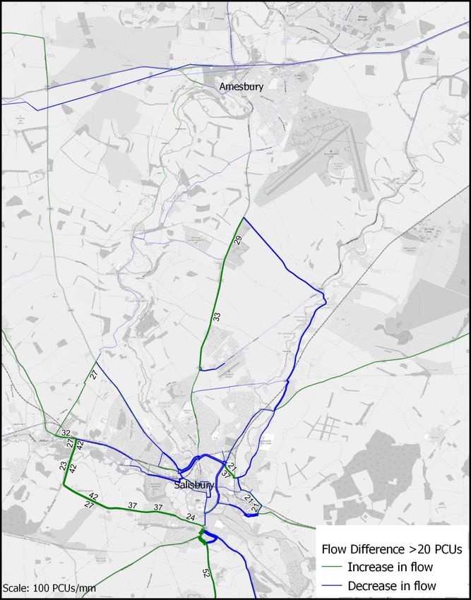
2.4. Assessing the impacts of Local Plan growth (Do-Minimum vs Do-
 Nothing)
2.4.1. Main traffic flow changes
Traffic is expected to increase primarily along the A350 corridor, particularly around Chippenham with an
additional 300-600 passenger car units (PCUs) per hour two-way. There is also expected to be an increase of
200-250 PCUs per hour in each direction on the A4 east of Chippenham. The other main strategic routes
across Wiltshire (A303, A36 etc.) are expected to carry an additional 100 PCUs.
The maps that follow are based on comparisons between the Do-minimum and Do-nothing scenarios. The
changes in traffic flows are presented in Figure 2-3 (A350 corridor) and Figure 2-4 (Salisbury and Amesbury
area); the wider the banding the greater the increase or decrease in flow, with decreases illustrated in blue and
increases in green. Both figures are presented for the AM peak only; the PM peak displays a similar pattern
and it is not deemed necessary to illustrate both.
Figure 2-3 - Changes in traffic flows from Local Plan growth to 2036 on the A350 corridor

 Generally,
 increases
 of 200

Wiltshire Local Plan | A | January 2021
Atkins | Wiltshire Local Plan Transport Review - for issue Jan 2021 Page 13 of 64
Figure 2-4 - Changes in traffic flows from Local Plan growth to 2036 in Salisbury and Amesbury

 Generally,
 Increases
 of 20

2.4.2. Assessment of ‘severe’ impacts
The maps in Figure 2-5 and Figure 2-6 present the impacts of this additional traffic on the network, with specific
reference to where there could be potential for severe impacts. There are several locations where the impacts
can be considered “severe”, where the Volume to Capacity Ratio exceeds capacity as illustrated by the black
lines and red lines which are reaching capacity.

Wiltshire Local Plan | A | January 2021
Atkins | Wiltshire Local Plan Transport Review - for issue Jan 2021 Page 14 of 64
Figure 2-5 - Impacts of forecast Local Plan growth on the A350 corridor

Without Local Plan (Do-Nothing) With Local Plan (Do-Minimum)

 Main capacity
 issues on A350
 and approaches
 to Chippenham,
 Melksham and
 Trowbridge

Impacts forecast by traffic volume to road capacity ratio (V/C%), AM peak period (08:00-09:00)

Wiltshire Local Plan | A | January 2021
Atkins | Wiltshire Local Plan Transport Review - for issue Jan 2021 Page 15 of 64
Figure 2-6 - Impacts of forecast Local Plan growth in Salisbury and Amesbury

Without Local Plan (Do-Nothing) With Local Plan (Do-Minimum)

 Capacity
 issues in south
 Salisbury and
 residual issues

Impacts forecast by traffic volume to road capacity ratio (V/C%), AM peak period (08:00-09:00)

Wiltshire Local Plan | A | January 2021
Atkins | Wiltshire Local Plan Transport Review - for issue Jan 2021 Page 16 of 64
3. Mitigating impacts of Local Plan growth
3.1. Approach to identification of the mitigation package
The following mitigation measures have been proposed in order of priority according to the Wiltshire Local
Transport Plan modal hierarchy: active travel (section 3.2); public transport (section 3.3) and highway
measures (section 3.4). The impacts of the combined package of measures are presented in section 3.5.
Whilst a policy shift to encourage active modes and public transport is highest on the hierarchy of measures,
car trips are dominant for journeys over 1 mile in Wiltshire (which is the focus for this modelling work). Walking
and cycling constitute less than 10% of journeys, bus and rail less than 10% and journeys by car more than
80% (see Appendix C). The proposed measures therefore reflect the feasibility of achieving of mode shift for
different types of movement within and between the towns. Further guidance on the approach to determination
of interventions is provided in Appendix A.

3.2. Walking and cycling mitigation measures
Key walking and cycling routes have been identified in each of the three principal settlements; Chippenham,
Trowbridge and Salisbury. The proposed radial corridors all serve the inner urban areas including the main
attractors: schools, employment, town centres and railway stations. The measures include fully segregated
cycle routes, advisory lanes and pedestrian/toucan crossings.
In Chippenham, a crossing of the River Avon, at the south end of Charter Park, would provide pedestrians and
cyclists in the preferred sites east of Chippenham with a more direct route to the western side of Chippenham.
The preferred sites at Trowbridge are located to the north-east of the town and the new radial cycle routes
focus on connecting these new developments with the town centre and Trowbridge railway station. Multiple
secondary routes also provide improved cycling infrastructure for the existing population in the south-west of
Trowbridge. Salisbury already has some of the highest levels of commuter cycling in Wiltshire at 4.8%. Its
walking and cycling improvement package will enhance this with eleven sections of new cycle infrastructure
Figure 3-1 - Chippenham new walking and cycling infrastructure

Wiltshire Local Plan | A | January 2021
Atkins | Wiltshire Local Plan Transport Review - for issue Jan 2021 Page 17 of 64
Figure 3-2 - Trowbridge new walking and cycling infrastructure 4

Figure 3-3 - Salisbury new walking and cycling infrastructure

4 The prospective Local Plan housing ‘square’ in Bradford-on-Avon represents an indicative housing allowance for the town, with no
specific sites yet identified.

Wiltshire Local Plan | A | January 2021
Atkins | Wiltshire Local Plan Transport Review - for issue Jan 2021 Page 18 of 64
3.2.1. Complementary Measures
The routes outlined in the previous section will provide safe, well signed routes to railway stations from across
the three principal settlements of Chippenham, Trowbridge and Salisbury. Improved local walking and cycling
access will be targeted at these three key stations, with the aim of creating sustainable transport hubs that help
increase the numbers of active travel users of these new cycle routes to/from the stations to capture these
sustainable modes as part of a longer commute, which would otherwise by undertaken in full or part by private
car. These could include secure indoor bicycle parking areas, secure lockers, improved cycle and scooter hire
facilities, and digital initiatives including parking and charging for electric bicycles and scooters.
It is estimated that a combined total of approximately 6,000 cycle trips per day could be added to Chippenham,
Trowbridge and Salisbury’s transport networks. This is equivalent to an average increase of over 100% on
existing cyclist numbers for all-purpose trips. The improved active travel infrastructure would also support
increased walking, although the limitations on existing data mean that this cannot be reliably estimated.
The DfT aims to double cycling in the UK by 20255 and these measures would support this goal. Other areas
for intervention, such as parking initiatives, could further increase the uptake in walking and cycling. The
methodology used to calculate this impact is presented in Appendix E.

3.3. Public transport mitigation measures
3.3.1. Principles for identifying schemes
The principles for identifying public transport mitigation schemes are summarised below:
• Public transport is suitable for connecting developments to key trip generators (e.g. employment hubs,
 major hospital sites and education establishments), particularly in conjunction with active modes;
• Public transport can contribute to reducing congestion through a reduction in local and inter-urban car trips;
• It contributes to reducing carbon emissions and impacts on air quality through a reduction in local car trips;
• Any new services need to be commercially viable – it may not be possible to introduce new services for
 individual small-scale developments; and
• Consideration should be given to providing links to public transport services that enable longer distance
 journeys, e.g. rail stations.

3.3.2. Rail strategy
It is likely to prove challenging to increase the frequency of rail services in response to the Local Plan. The
approach is instead to improve access to the main rail hubs in Chippenham, Trowbridge and Salisbury. These
are the busiest stations: they collectively accommodate well over half of all rail passengers in Wiltshire and
offer the most frequent and widest destination choice connections.
The number of people who board trains at the stations is not in proportion to the population of each town. For
example:
• Chippenham has ~15,000 households with annual rail patronage at the station of 1.9 million passengers
 (with services to Bristol, Bath, Swindon, Reading and London);
• Trowbridge has ~17,000 households with 0.9 million passengers (direct services to Bristol, Bath, Salisbury
 and Southampton); and
• Melksham has ~8,000 households with only 74,000 passengers using Melksham station (which has much
 more limited services).
There is clearly a high demand for rail from residents or employers outside these main stations who either
travel from outside these areas or would benefit from improved, sustainable access to them. The strategy
therefore focuses on encouraging people to access Chippenham, Trowbridge and Salisbury stations, and the
central areas and associated attractions and employment, via active modes or bus.

5
 Department for Transport: Cycling & Walking Investment Strategy (2020) – ‘Double cycling: where cycling activity is measured as the
estimated total number of cycle stages made each year, from 0.8 billion stages in 2013 to 1.6 billion stages in 2025’

Wiltshire Local Plan | A | January 2021
Atkins | Wiltshire Local Plan Transport Review - for issue Jan 2021 Page 19 of 64
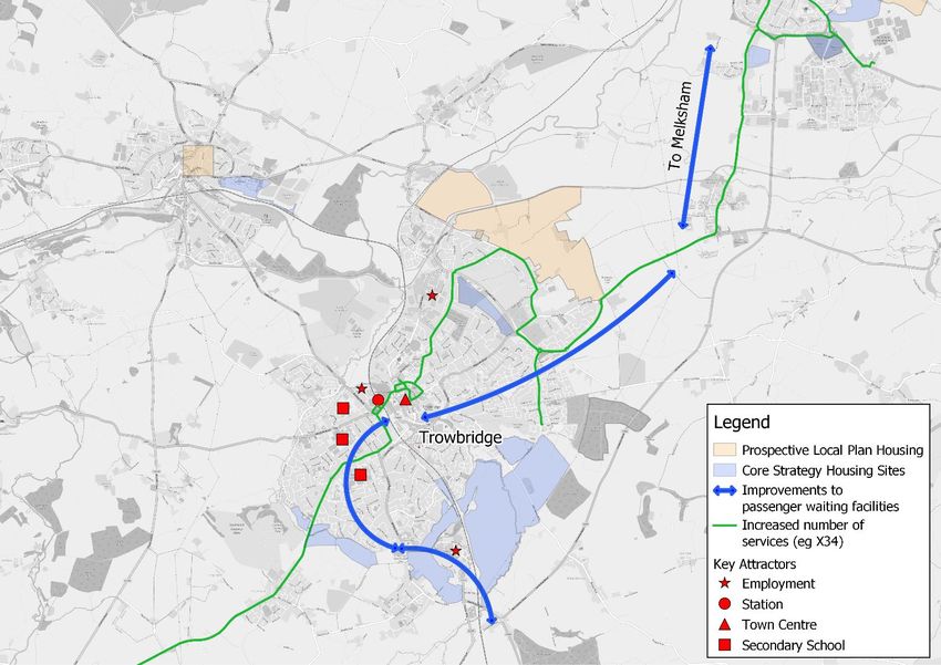
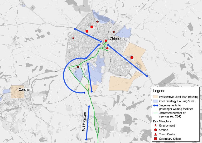
3.3.3. Bus strategy
The main locations of growth are on the A350 corridor: Chippenham, Melksham, Trowbridge and Westbury,
towns that are likely to support more than half of Wiltshire’s prospective Local Plan growth.
There are currently low levels of bus patronage on the A350 corridor. However, the focus on growth in the A350
corridor provides the opportunity to maintain the viability of bus services along the corridor. The focus of the
strategy is therefore to improve access to Chippenham and Trowbridge town centres through a combination of
active travel measures (previously described) and improvements to bus provision. Developers should be
required to contribute funding for enhancements to services and supporting infrastructure.
Salisbury benefits from more frequent bus services across the city, which is reflected in higher levels of bus
patronage. It is considered that the preferred sites can be served by existing services with enhanced
frequencies and/or extended provision. Again, Developers should be required to contribute funding for
enhancements to services and supporting infrastructure.
The methodology for determining current and forecast rail and bus patronage and evidence for the proposed
mitigation strategy can be found in Appendix F.
Bus service and infrastructure improvements along the A350 corridor are identified as the most important
priority, with a focus on the corridor between Chippenham and Trowbridge. The Market Towns will be
addressed at a later date and are likely to identify further requirements. The key trip generators (train stations,
employment centres, town centres and secondary schools) are shown in Figure 3-4 and Figure 3-5 below.
The X34 route is the main bus service using the A350 corridor and other bus services will also be considered in
serving Chippenham and Trowbridge.
Figure 3-4 - Bus corridors to support Local Plan growth: Chippenham

Wiltshire Local Plan | A | January 2021
Atkins | Wiltshire Local Plan Transport Review - for issue Jan 2021 Page 20 of 64
Figure 3-5 - Bus corridors to support Local Plan growth: Trowbridge

Note: bus service provision to support growth in Melksham will be considered at a later date.

3.3.4. Mitigation recommendations
Five key bus corridors are recommended as priorities for investment (currently served by different routes):
• Chippenham east (Route 44M);
• Chippenham south-east (Routes 33, X33, 55, 55A, X10);
• Chippenham west (Routes X10, X31, 35, 44);
• Trowbridge north-east (Routes X34, 49, X49, 68); and
• Trowbridge south-east (Routes D1, 87, 87A).

The corridors in Chippenham connect new development south and east of the town to destinations including
the town centre and railway station. Bus services in Chippenham currently have the worst reliability of all
services in Wiltshire, which must be addressed.
Between Chippenham, Melksham and Trowbridge, services could also potentially provide a more attractive
mode of travel between the towns as an alternative to the private car.
Potential improvements on the five corridors could include:
• Improvements to passenger waiting facilities at stops and interchanges;
• Real time information at key bus stops and interchanges;
• Increased number of services;
• Diversion of existing services to serve new housing sites;
• Investigation of potential dynamic demand responsive transport (DDRT) solutions; and
• Potential for additional bus depots to be provided within Wiltshire to help improve service efficiency.

Wiltshire Local Plan | A | January 2021
Atkins | Wiltshire Local Plan Transport Review - for issue Jan 2021 Page 21 of 64
Table 3-1 summarises the bus corridors identified for improvement in Chippenham and Trowbridge, introducing
infrastructure schemes and service improvements that could be implemented to support uptake in bus
patronage from the new housing developments.

Table 3-1 - Chippenham and Trowbridge public transport improvements

 Chippenham Trowbridge
 Access sites East South-East West North-East South-East
 Existing services 44M 33, X33, 55, 55A, X10, X31, 35, 44 X34, 49, X49, 68 D1, 87, 87A
 X10.
 Bus corridors London Road / Cocklebury Road / Bristol Road Hilperton Drive / Westbury Road /
 The Causeway Station Hill Marsh Road / Bradley Road
 Canal Road /
 The Down
 Infrastructure Passenger waiting facilities, Possibility for bus priority measures along route, but not included in
 schemes assessment or costing. Bus depot provision (not included in costing).
 Bus service New or diverted service for new development sites. Increase bus frequencies.
 improvements

3.3.5. Additional recommendations and next steps
It is recommended that two aspects of further work are undertaken in the next phase. First, more work will be
required to develop the options to improve bus services in the five corridors identified above. Second, further
work is required to review connectivity between the principal settlements and market towns, to examine the
scope for mode shift and to reduce traffic congestion on the approaches to the principal settlements.
In addition to public transport infrastructure and service frequency improvements, dynamic demand responsive
transport (DDRT) options could also be considered to further increase the penetration of public transport
services to new developments. DDRT solutions use smaller vehicles, often minibuses, that passengers can
book using an app and are picked up from local collection points to connect to the wider public transport
network. In some cases, the scale of individual developments may not be viable for existing public transport
services to re-route, given the relatively low levels of demand. DDRT solutions therefore operate to serve direct
demand (like a minibus taxi, booked through an app) and are not running empty vehicles to a timetable, unlike
the requirements of a conventional public transport service.
DDRT measures could form a component in the public transport strategy for developments in the principal
settlements and are also likely to support the transport strategies for Wiltshire’s Market Towns (and surrounding
rural catchments), which will be addressed in the next phase of work.

3.3.6. Assessment of current public transport mitigation measures
At present, there are high levels of car dependence for many trips and the current public transport network is
not sufficiently frequent to attract significant numbers of car users. Bus patronage across large parts of
Wiltshire is therefore relatively low. Improvements to bus services and infrastructure, as described above,
would improve the attractiveness of buses to potential users, but the scale of change is likely to be modest.
This means that there is likely to be limited mode shift from travel by car in the absence of more significant
improvements and measures to manage traffic demand. This, in turn, would mean that there are likely to be
limited impacts on traffic congestion and delays on the road network.
However, the Covid-19 pandemic has caused unprecedented changes in the ways that people live their lives.
Many people have been working from home, shopping on-line and staying in their local areas. This has created
huge changes in travel demand during the last year (including the large reduction in rail and bus demand since
March 2020). There are likely to be significant changes in the ways that people travel following the pandemic.
There are, however, huge uncertainties: the extent to which home working will continue and future use of
workplaces, the relative importance of online versus ‘bricks and mortar’ retail and the nature of leisure travel.
The next stage of assessment should consider these issues. This should include a ‘scenario planning’ process
to review the emerging trends, scope different alternative futures and identify the implications for travel
demand. This will include the potential implications for future public transport use, as well as walking, cycling
and cars and goods vehicle traffic.

Wiltshire Local Plan | A | January 2021
Atkins | Wiltshire Local Plan Transport Review - for issue Jan 2021 Page 22 of 64
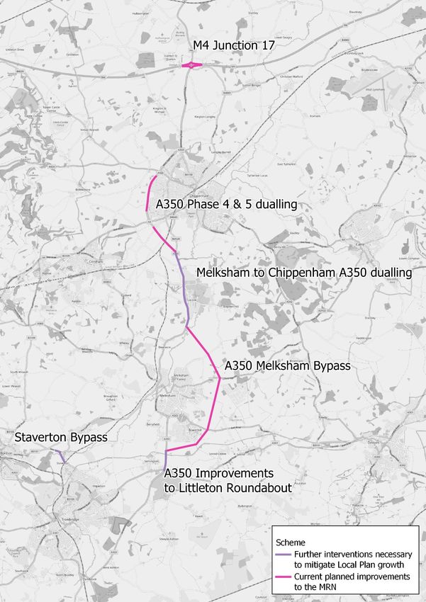
3.4. Highway mitigation measures
Based on the impacts that were identified in the previous section and the large scale of housing modelled for
Chippenham (5,100 dwellings), Melksham (2,675 dwellings), Trowbridge (1,800 dwellings) and Westbury
(1,125 dwellings), improvements to the A350 are likely to be required. Capacity improvements at key
pinchpoints on the A350 have been tested in the Do-something (DS) scenario.
The Do-Something scenario includes a series of planned highway interventions to mitigate the impacts of
current policy led growth and Local Plan growth on the highway network. These interventions include a series
of schemes that have been developed in further detail as part of a programme of improvements to the Major
Road Network (MRN). Each of these schemes is the subject of a Strategic Outline Business Case (SOBC)
approval from DfT and these are progressing through the next stage of business case submission. The
schemes reflect the design evolution at the end of SOBC and do not reflect current and ongoing design
evolution and consultation:
• A350 Melksham Bypass (Appendix D.1);
• A350 Phase 4 and 5 Dualling (Appendix D.2);
• M4 Junction 17 (Appendix D.3); and
• A338 Salisbury Junctions (Appendix D.4).
In addition, the testing has identified the potential need for further interventions to mitigate impacts on other
parts of the network. These are:
• Dualling of the A350 from Lackham roundabout to the proposed Melksham Bypass;
• Dualling of the A350 from the Littleton roundabout near Semington to the new junction with the proposed
 Melksham Bypass and capacity improvements at the A350/A361 roundabout near Semington; and
• Improvements to the operation of Staverton Bridge (Appendix D.5).

3.4.1. Assessment of highway interventions
All these schemes have been coded into the highway model using standard coding assumptions. Several
model iterations have been undertaken to optimise and refine the highway requirements and ensure that the
expected highway reassignment based on possible capacity improvements has been undertaken.
The indicative designs for the improvements to the Major Road Network were used to inform the coding of
these schemes. Designs have not yet been developed for dualling of the A350 (Lackham Roundabout to
proposed Melksham Bypass) and A350 improvements between Littleton Roundabout and proposed Melksham
Bypass. In these cases, indicative capacity improvements were coded in the strategic model, including
increased link and junction capacities.
A map showing the locations of the proposed highway schemes (in Western Wiltshire) is shown in Figure 3-6.
The Salisbury Junctions scheme is shown in Appendix D.4. Additional schemes which could be included in
future assessments are discussed in the conclusions (see Chapter 4).

Wiltshire Local Plan | A | January 2021
Atkins | Wiltshire Local Plan Transport Review - for issue Jan 2021 Page 23 of 64
Figure 3-6 - Schemes already developed as improvements to the Major Road Network (MRN) and further
interventions to mitigate Local Plan growth

Wiltshire Local Plan | A | January 2021
Atkins | Wiltshire Local Plan Transport Review - for issue Jan 2021 Page 24 of 64
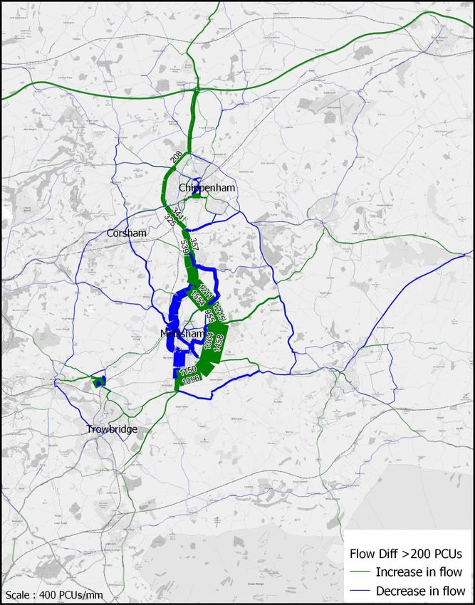
3.5. Assessing the performance of the combined mitigation package
3.5.1. Transport impacts
The forecast impacts of the combined mitigation measures (active travel, public transport and highway
schemes), are presented in the plots below. The changes in traffic flows and operational performance are
presented in Figure 3-7 to Figure 3-10. This is for the AM Peak, the changes in other time periods are similar.
Figure 3-7 - Changes in traffic flows with suggested combined mitigation on the A350 corridor

 Mitigation
 package results
 in additional trips
 on the A350 and
 reductions into
 central urban
 areas

Increase over the AM peak period (08:00-09:00), numbers displayed are for trip changes >200

Wiltshire Local Plan | A | January 2021
Atkins | Wiltshire Local Plan Transport Review - for issue Jan 2021 Page 25 of 64
Figure 3-8 - Changes in traffic flows with suggested combined mitigation in Salisbury and Amesbury

 Reductions in
 highway trips
 into city centre

Increase over the AM peak period (08:00-09:00), numbers displayed are for trip changes >20

Wiltshire Local Plan | A | January 2021
Atkins | Wiltshire Local Plan Transport Review - for issue Jan 2021 Page 26 of 64
Figure 3-9 - Impacts of mitigation on the A350 corridor

With Local Plan (Do-Minimum) With Local Plan Mitigation (Do-Something)

 Main capacity Significant
 issues: A350, M4 reduction in
 J17 and volume and
 Chippenham, intensity of links
 Melksham and with capacity
 Trowbridge areas constraints

Impacts forecast by traffic volume to road capacity ratio (V/C%), AM peak period (08:00-09:00)

Wiltshire Local Plan | A | January 2021
Atkins | Wiltshire Local Plan Transport Review - for issue Jan 2021 Page 27 of 64
Figure 3-10 - Impacts of mitigation in Salisbury and Amesbury

With Local Plan (Do-Minimum) With Local Plan Mitigation (Do-Something)

Impacts forecast by traffic volume to road capacity ratio (V/C%), AM peak period (08:00-09:00)

Wiltshire Local Plan | A | January 2021
Atkins | Wiltshire Local Plan Transport Review - for issue Jan 2021 Page 28 of 64
Further to the trip impacts illustrated in the previous figures, Appendix H provides an economic assessment of
the schemes, as derived from the scheme costs given within Appendix G, and illustrates a positive costs to
benefits ratio; i.e. the schemes deliver economic benefits which outweigh their delivery costs.

Wiltshire Local Plan | A | January 2021
Atkins | Wiltshire Local Plan Transport Review - for issue Jan 2021 Page 29 of 64
4. Conclusions and Summary
4.1. Impacts of Local Plan growth without mitigation
The forecast scenarios were developed using the Department for Transport’s required approach to travel
forecasting and TRICS trip rate assumptions. This assessment has tested the impacts on the transport network
of approximately 18,000 additional homes identified in the prospective Local Plan Review.
Different modelling scenarios were developed to represent the effects of the Local Plan growth on Wiltshire and
the wider region. This included a Do Nothing (excluding the Local Plan growth) and Do Minimum (including
prospective Local Plan growth).
Without mitigation measures there could be considerable capacity constraints and congestion issues on the
local and strategic road network between settlements. The main highway pinchpoints are located along the
A350 corridor and M4 Junction 17, which will serve over half of the additional proposed Local Plan growth:
Chippenham (5,100 dwellings), Melksham (2,675 dwellings) and Trowbridge (1,800 dwellings). Further
assessment will be required to test the impacts of development at the Market Towns.

4.2. Proposed mitigation
4.2.1. Active modes
Walking and cycling corridors (see section 3.2) were identified in each of the three principal settlements;
Chippenham, Trowbridge and Salisbury. Identifying safe and effective cycle routes along these corridors will
increase the attractiveness of cycling as a mode of travel within Wiltshire’s principal settlements. High level
cycle route designs have been included in this mitigation package. Analyses using the DfT’s recommended
appraisal methodology estimate a combined increase of approximately 6,000 cycle trips per day across the
three principal settlements, resulting in around 600 car trips removed from Wiltshire’s roads per hour. The cost
of the active mode schemes is estimated to be approximately £31.7 million (in 2020 values).

4.2.2. Public transport
The bus and rail services (see section 3.3) that are near to most of the housing follow (or are parallel to) the
A350 serving Chippenham, Melksham and Trowbridge. Proposed improvements include improvements to
passenger waiting facilities at stops and interchanges, Real Time Information at key bus stops, increased
numbers of services, diversion of existing services to serve new housing and investigation of Dynamic Demand
Responsive Transport (DDRT) solutions. The estimated cost of these measures is approximately £10.5 million
(in 2020 values).
However, a lack of data regarding up to date patronage numbers for Wiltshire’s bus and rail services allows for
only very high-level analysis. The data that was available suggests only a low level of existing bus use across
most parts of the county. It is therefore likely that improvements to public transport provision would have a
limited impact on car use. This would, in turn, mean limited impacts on congestion on the road network, and the
effects have not been included in the appraisal.
However, it is recognised that the Covid-19 pandemic has caused major impacts on travel demand since the
first lockdown in March 2020. The future implications for travel demand, including bus and rail use, are not
currently clear. It is recommended that further work is undertaken to review trends and develop future potential
scenarios to inform more detailed assessment of the implications for public transport in the area.

Wiltshire Local Plan | A | January 2021
Atkins | Wiltshire Local Plan Transport Review - for issue Jan 2021 Page 30 of 64
4.2.3. Highway impacts and mitigation
The proposed scale of development at the settlements along the A350 corridor is forecast to create significant
pressures on this part of the road network. In the case of Chippenham and Melksham, new road connections
will help to mitigate the impacts of additional development in each town. However, the analyses have indicated
potential requirements for significant capacity improvements on the A350 between the towns along the route.
At Chippenham, it has been established that major infrastructure will be required to unlock strategic housing
development. The previous Chippenham Site Allocations Plan (CSAP) established the requirement for a new
Eastern Distributor Road, connecting around the north of the town from the A4 east of Pewsham to the A350
at Malmesbury Road. The analyses in this study have also established the requirement for a new Southern
Distributor Road, connecting around the south of the town from the A4 east of Pewsham to the A350 at
Lackham Roundabout.
In addition, the planned mitigation at Chippenham includes the existing proposals for Phase 4 & 5
improvements to the A350 Chippenham Bypass, as a major improvement to the Major Road Network. This
major infrastructure, together with complementary measures to promote mode shift to walking, cycling and
public transport for local journeys, will be critical in mitigating the impacts of strategic development in the town.
In the case of Melksham, the existing proposals for the Melksham Bypass will play an important role in
helping to mitigate the impacts of strategic development in the town. This planned Major Road Network (MRN)
scheme will tackle congestion in the town and provide new capacity to accommodate traffic from new
development. An indicative design has been developed for the scheme; this will need to be reviewed and
refined to take account of the requirements of the proposed development.
In Trowbridge, the assessments have not identified the requirement for further strategic highway infrastructure
in the town. The recently constructed B3105 Elizabeth Way between Hilperton Marsh and the A361 Fieldways
roundabout will play an important role in catering for new strategic development in the town. Measures to
promote mode shift to walking, cycling and public transport for local journeys will help to mitigate the impacts of
strategic development in the town. However, the requirement has been identified for a Staverton Bypass to
mitigate the impacts of additional traffic at this pinchpoint on the network. This scheme, which forms a viaduct
across floodplain, is the subject of a development funding bid for Local Levy Fund through Wessex Regional
Flood and Coastal Committee.
The assessments have demonstrated that there will be further impacts on the A350 corridor outside the
settlements. The initial focus has been on addressing impacts at the following locations:
• M4 Junction 17. A Major Road Network (MRN) scheme has already been developed, which has been
 included in the proposed mitigation package. The testing demonstrates that this would be effective in
 mitigating the impacts of additional traffic generated by strategic development in the A350 corridor.
• A350 between Lackham Roundabout and proposed Melksham Bypass. The testing indicates that this
 section of the A350 near to Lacock would be approaching capacity. Dualling of this section (or other
 options to improve link and junction capacities) would help to mitigate increased traffic delays.
• A350 between proposed Melksham Bypass and Littleton Roundabout. A limited section of dualling of
 this section of the Semington Bypass would help to ensure effective management of traffic heading
 southwards on the A350 towards Westbury and A361 towards Trowbridge.
The assessments have also shown that there will be significant impacts on the A350 south of Semington
towards Westbury and Warminster. The forecasts indicate the likelihood of increased congestion on the
approaches to Stoney Gutter traffic lights and on the planned Yarnbrook to West Ashton Bypass. Increased
congestion is also forecast on the A350 through Westbury and onwards towards Warminster. Interventions
have not, to date, been identified for these sections (apart from the Yarnbrook to West Ashton Bypass). It is
recommended that a comprehensive strategy should be considered to assess the longer-term issues and
options for the route.
The more modest proposed scale of growth at Salisbury would have less significant impacts on the road
network in southern Wiltshire. The proposed programme of active travel improvements will help to reduce car
dependency and reduce traffic on key routes into the city. The proposed A338 Southern Salisbury junction
improvements (Exeter Street and Harnham Gyratory) will help to mitigate the impacts of additional traffic from
new development to the south of the city.
The existing Major Road Network (MRN) schemes (M4 Junction 17, A350 Phase 4&5 dualling, A350 Melksham
bypass and A338 southern Salisbury junctions) are estimated to cost approximately £213 million, in 2020
values. The additional schemes (Staverton Bypass, capacity improvements to Littleton roundabout (A350/A361
roundabout near Semington) and dualling of 1km of the A350 north of Littleton roundabout and dualling of
4.5km section between Lacock roundabout and the Melksham Bypass) is estimated to cost approximately £93
million (in 2020 prices).

Wiltshire Local Plan | A | January 2021
Atkins | Wiltshire Local Plan Transport Review - for issue Jan 2021 Page 31 of 64
4.3. Impacts of mitigation
The combined mitigation packages are considered to mitigate a large proportion of the impacts, although there
remain residual impacts that would require further investigation. Links and junctions shown to be severely
impacted by the Local Plan growth, for example the A350 south of Melksham and M4 Junction 17, will be
successfully mitigated when both the Local Plan schemes and MRN schemes are combined.
If these wider impacts are taken into account, it is considered that there could be potential to achieve High
Value for Money, hence a relatively strong Economic Case and good potential for securing funding.

4.4. Next steps
Further assessment will be required to test, analyse and mitigate the impacts of development within the Market
Towns. This further work will feed into this consideration of the Principal Settlements and allow for further
investigation of mitigation proposals. This should include:
• Assessment of potential scenarios for changes in future travel demand, including increased home-working
 and online retail, following the COVID-19 pandemic;
• Explore the potential for increased modal shift within settlements towards active travel, particularly given a
 future focus on ’15-minute neighbourhoods’, with more local living and shopping;
• Planning for a step-change in the quality and attractiveness of public transport, including more flexible
 services that better respond to people’s needs, ‘Mobility as a Service’ information and ticketing apps and
 high-quality interchange between modes;
• More explicit consideration of the carbon reduction agenda, including adoption of an ‘Avoid-Shift-Improve’
 approach6 to reducing the need to travel, shifting to zero carbon modes and accelerating the uptake of
 electric vehicles;
• Further consideration of the implications for strategic corridors in Wiltshire, most importantly the A350
 north-south corridor but also the A303 in South Wiltshire and A4 and A36 connecting to the West of
 England;
• Further development of options, work to inform the forward infrastructure pipeline and programming of the
 mitigation package.

4.4.1. Locations recommended for further investigation
As highlighted above, several locations require further investigation to develop appropriate mitigation measures
(as shown in Figure 3-9). These include:
• The proposed Melksham Bypass has been identified as approaching capacity with the proposed scale of
 growth along the A350. Further refinement of the design of this scheme will be required to ensure that it
 can adequately accommodate the proposed growth; this will be developed in coordination with higher
 impact active travel and sustainable travel measures;
• A350 south of A361 Littleton roundabout – Stony Gutter Lights – Yarnbrook (including Yarnbrook to West
 Ashton Bypass; capacity improvements are likely to be required to the planned bypass);
• Westbury (the location of preferred option housing will require further consideration of how this will impact
 on the local network); and
• A350 south of Westbury, towards Upton Scudamore and Warminster.
It is recommended that a comprehensive Route Strategy is developed for the A350 corridor between
Warminster and Chippenham. This should consider options to secure higher levels of modal shift along the
corridor, together with the long-term requirements for improved highway infrastructure to tackle congestion and
journey time reliability, whilst at the same time supporting Wiltshire Council’s ambitions for Net Zero carbon
emissions.
In addition, potential issues have been identified in other market towns across Wiltshire. These issues relate to
the growth that was assumed in the modelling work to date and will need to be investigated as growth options
are explored for the towns. For example, issues have been identified around Devizes, Corsham, Calne and
Royal Wootton Basset. These should be addressed in the next phase of work.

6
 The Avoid-Shift-Improve approach has been adopted by many organisations as an integrated framework for reducing greenhouse gases
emitted by the transport system. ‘Avoid’ (or ‘Reduce’) refers to the need to reduce motorised travel through, for example, transport-oriented
development and Transport Demand Management. ‘Shift’ interventions are focused on encouraging a shift from cars to more
environmentally friendly modes, e.g. walking, cycling and public transport. ‘Improve’ interventions focus on improving efficiency through
vehicle technology, including accelerating the adoption of electric and zero emissions vehicles.

Wiltshire Local Plan | A | January 2021
Atkins | Wiltshire Local Plan Transport Review - for issue Jan 2021 Page 32 of 64
You can also read