Windows to the Deep 2018: Exploration of the Southeast U.S. Continental Margin (EX1805 and EX1806)
←
→
Page content transcription
If your browser does not render page correctly, please read the page content below
Windows to the Deep 2018:
Exploration of the Southeast
U.S. Continental Margin
(EX1805 and EX1806)
NOAA Ship Okeanos Explorer
May 22 – July 2, 2018

Windows to the Deep 2018: Exploration of the Southeast U.S. Continental Margin was NOAA Ship Okeanos Explorer’s first
expedition of the Atlantic Seafloor Partnership for Integrated Research and Exploration (ASPIRE) campaign, a major multi-
year, multi-national collaborative field program focused on raising collective knowledge and understanding of the North
Atlantic Ocean.

Expedition Summary
The Windows to the Deep 2018: Exploration of the Southeast
U.S. Continental Margin was a 36-day telepresence-enabled
expedition to collect critical information and acquire
data on priority exploration areas identified by the ocean
management and scientific communities. This expedition
involved exploration of a diversity of features across the
southeast U.S. continental margin with mapping and
remotely operated vehicle (ROV) operations targeting
areas with potential to host deep-sea coral and sponge
communities, maritime heritage sites, a landslide feature,
and water column sonar anomalies of possible cold seeps
where gas bubbles emanate from the seafloor. Mapping
data collected during this expedition filled major data gaps
in the region and will contribute to Seabed 2030 goals
for mapping unexplored regions of Earth’s oceans. This
expedition also marked over 400 ROV dives for NOAA Ship
Okeanos Explorer. Major accomplishments of this expedition
are summarized below.

Conducted 17 ROV dives ranging in depth from 325 to 3,436
meters to improve knowledge of unexplored areas within the
U.S. Exclusive Economic Zone (EEZ) and in deepwater areas
previously mapped for the U.S. Extended Continental Shelf         Overview map showing seafloor bathymetry and ROV
Project to inform management needs for sensitive habitats,        dives completed during the Windows to the Deep 2018
maritime heritage sites, and potential resources. Data            expedition (EX1805 and EX1806). Map courtesy of the
collected can be used to increase understanding of deep-sea       NOAA Office of Ocean Exploration and Research.
ecosystem connectivity across the Atlantic basin.
• Collected 175 biological (53 primary and 122 associates) and 38 geological specimens. Biological specimens were
representatives of new records, potential new species, dominant fauna, or were collected to support trans-Atlantic
connectivity studies. Geological samples will be used to better understand the geologic history of this region, as well
as to characterize habitat substrate.
ӱӱ Collected six biological samples to support trans-Atlantic connectivity studies including Geodia pachydermata,
Bathypathes sp., Leiopathes sp., Anthomastus sp., Lophelia pertusa, and Pheronema sp.
• The Windows to the Deep 2018 Expedition and previous
Okeanos Explorer mapping efforts, revealed of one of
the largest areas of potential deep-sea coral reef habitat
that has been discovered to date in U.S. waters. Through
both mapping and visual surveys, this expedition added
substantial evidence that the numerous mounds on the
Stetson Mesa offshore of Florida and Georgia appear
to be the slow accumulation of Lophelia pertusa coral
skeletal material over hundreds of thousands of years.
This expedition only explored three mounds, but all
were rich with live coral stands at their crests. New
data highlights the vastness of potential deep-sea coral
habitat in this region.
• Conducted ROV dives and mapping operations in
two areas managed by the South Atlantic Fisheries
Management Council (SAFMC) - the Stetson Miami
Terrace Deep Coral Habitat Area of Particular Concern
(HAPC) and Cape Fear Lophelia Banks Marine Protected
Area (MPA).
ӱӱ Mapped over 7,400 square kilometers and
conducted three dives in the Stetson Miami Terrace
Deep Coral HAPC that revealed high-density
coral communities at each site. Two of these
communities were also highly diverse.
ӱӱ Conducted an ROV dive in Cape Fear MPA,
documenting several large wreckfish (Polyprion
americanus), a commercially important species
managed by the SAFMC.
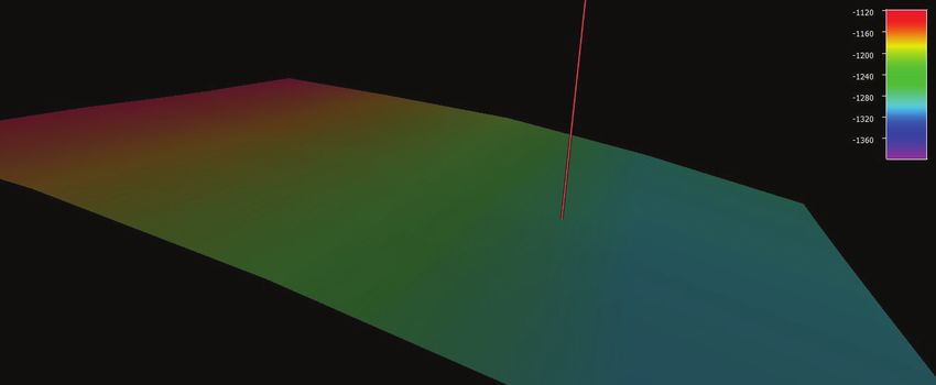
Prior to the Windows to the Deep 2018 expedition, this
• Discovered a high diversity of deep-sea corals and section of the Blake Escarpment appeared to be an area
sponges on low relief, intraslope terraces (terraced of low slope with no distinct features based on satellite
features between a depth of 1,000 to 4,000 meters) altimetry. Image A shows satellite altimetry (Smith and
along the Blake Escarpment in areas with no previous Sandwell, 2014) at Dive 04 on “Blake Escarpment South”.
exploration. During EX1805, multibeam mapping revealed a series
of terraced features (image B); and ROV exploration
• Explored two potential archeological sites to support the
during EX1806 documented a highly diverse and dense
Bureau of Ocean Energy Management (BOEM) and NOAA
community of deep-sea corals and sponges that were
maritime heritage programs.
observed throughout the dive (image C). Red mark in
ӱӱ Characterized the Blake Ridge Wreck and collected bathymetry images indicates the location of the ROV dive.
data that was used by BOEM to make a 3D
photogrammetry model. This wreck was originally discovered by a team from Duke University in 2015 and is likely
an early 19th century wreck.
ӱӱ Conducted targeted overnight mapping operations to search for other potential shipwrecks in an area suspected
to contain many due to the World War II Battle of the Atlantic, as well as merchant ships lost at sea along the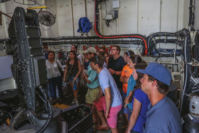
busy trade routes of the U.S. East Coast. Dive 13 investigated a sonar anomaly, dubbed “Big Dipper,” with very
strong backscatter, roughly the size and shape of a ship known to have sunk in the area offshore North Carolina;
ROV imagery revealed that this site was not a shipwreck, but instead a biologically diverse rocky habitat that was
home to a significant concentration of fish and corals.
ӱӱ Additional review of mapping data collected during this expedition is currently ongoing by the marine archaeology
community which may provide additional targets for future expeditions in the region.
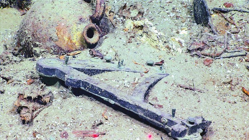
An octant discovered during the dive on Blake Ridge Wreck. This wreck was
originally discovered by a team from Duke University in 2015 and is likely an
early 19th century wreck. Other indicative artifacts imaged during the dive
included bottles of wine, ceramic jugs, containers for food and other liquids, a
small sewing kit with a pile of brass buttons, a slate, a vase, a tobacco pipe, and
a comb. Image courtesy of the NOAA Office of Ocean Exploration and Research,
Windows to the Deep 2018.
Located and characterized deep-sea coral, sponge, and chemosynthetic communities.
• Documented three dive sites with high biological
diversity and six medium diversity sites. Six dive sites
had high biological abundance/density or high biomass.
• Observed deep-sea corals and sponges on every dive
except one, which was a dedicated gas seep exploration
dive.
• Conducted two dives that targeted water column
anomalies. Both dives identified evidence of methane
seepage, with bacterial mats and fauna typically
associated with chemosynthetic habitats and active
bubble seepage in this region. A pair of golden crabs (Chaceon fenneri) occupy an
outcrop during the dive at Richardson Scarp. Based on
• Observed several potential new species, recorded
their behavior the scientists speculated that the pair
significant depth and geographic range extensions for
was mating. Image courtesy of the NOAA Office of Ocean
several fish and coral species, and documented the
Exploration and Research, Windows to the Deep 2018.
presence of commercially important species - including
red crab (Chaceon quinquedens) and golden crab
(Chaceon fenneri) - in areas not previously investigated.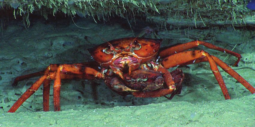
Characterized water column habitats using acoustics, visual observations, and emerging technologies.
• Conducted midwater exploration at depths ranging from 300 to 950 meters during three dives to investigate the
diversity and abundance of this largely unknown pelagic fauna.
• Made multiple observations of a species of medusa jellyfish (Cyanea sp.) in the deep waters above Keller Canyon.
This species is typically observed in shallow waters, which raises new questions about shallow and deep water
connectivity in the area.
Extended bathymetric mapping coverage in the U.S. EEZ and international waters in support of Seabed 2030.
• Mapped more than 29,600 square kilometers, an area larger than the State of Maryland.
• Made new insights into this region, including the discovery of previously unknown intraslope terraced feature; newly
mapped karstic features on the northern portion of the Blake Plateau; unusually flat seafloor terrain when compared
to predictions made by satellite altimetry on the southern Blake Plateau; and numerous likely biogenic ridges and
mounds offshore Florida, Georgia, and South Carolina. Due to their size, these features cannot be resolved from
satellite data and were only revealed in detail using the ship-mounted multibeam sonar.
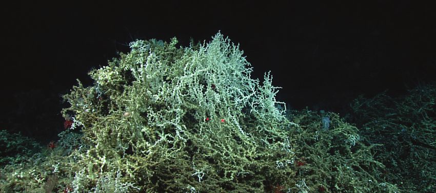
A stand of Lophelia pertusa at the top of one of the biogenic mounding features
explored within the Deep Water Coral Habitat Area of Particular Concern
along the Stetson Miami Terrace. Image courtesy of the NOAA Office of Ocean
Exploration and Research, Windows to the Deep 2018.
Collected mapping data and conducted ROV dives to support enhanced predictive capabilities for vulnerable
marine habitats and submarine geohazards.
• Discovered numerous areas of deep-sea coral and sponge habitat, which has not only improved our understanding of
this region, but has habitat modeling implications that may apply to many other places in the world.
• Conducted one ROV dive on the toe of the Currituck landslide feature, one of the largest submarine landslides on the
U.S. East Coast, to better understand past submarine geohazards.
Engaged over 140 scientists, resource managers, and students, which is a record high for Okeanos Explorer missions.
• Participants were from 21 U.S. states and four international countries including Russia, Portugal, Japan, and Norway.
Documented several rarely observed predation events. Highlights included:
• An Atlantic Midshipmen (Porichthys plectrodon) opportunistically grabbing a barracudina in the family Paralepididae
as it swam by during the dive at Pea Island.
• A lithodid crab ripping a brittle star apart along a sedimented ridge south of Pamlico Canyon.
• Inter-species predation activity between two crabs (Neolithodes sp. and Chaceon sp.) along a scarp feature in the
Richardson Hills area.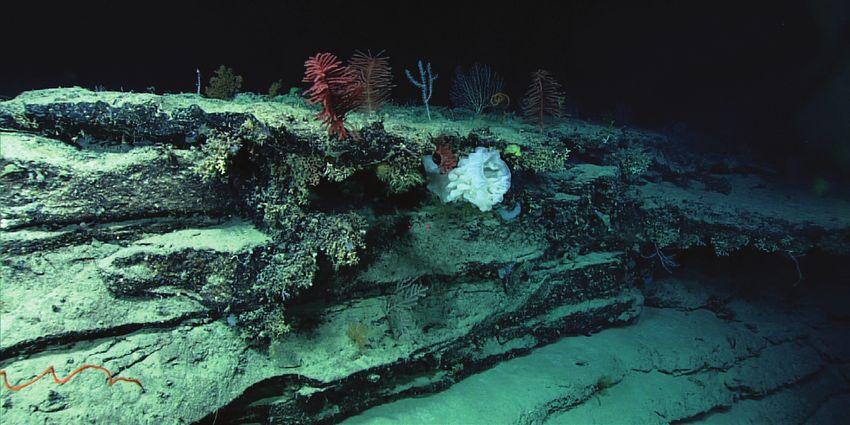
Virginia Sea Grant, members of NOAA Atlantic Hydrographic Branch, and
                     students tour NOAA Ship Okeanos Explorer at the conclusion of the expedition in
                     Norfolk, VA. Image courtesy of VA Sea Grant, Lisa Sadler.

Engaged with audiences around the world, opening a window of understanding into the deep sea.
 • Conducted six ship tours for 66 people, including tours for the SAFMC, the Mid-Atlantic Regional Council on the
   Ocean, Virginia Sea Grant, NOAA partners, South Carolina Aquarium, Patriots Point Naval and Maritime Museum staff,
   and students from the College of Charleston.
 • Conducted 16 live interactions, 18 live streaming events at partner locations, and a Reddit Science ‘Ask Me Anything’.
   Over 8,670 people were engaged during these events.
 • Over 80 news articles covered the expedition. Stories about the expedition appeared in national media as well as local
   outlets in landlocked areas and on both coasts, including the front page of Charleston’s Post and Courier. Several
   outlets published multiple stories about the expedition. International audiences were also engaged with articles in
   French, Italian, Spanish, Russian, Chinese, Indian, Cambodian, and Vietnamese, as well as several articles by news
   outlets in the United Kingdom.
 • Live video feeds received over 245,700 views during the expedition. Web content received 17,400 visits during the
   second leg of the expedition, with more than 54,000 additional views coming in the weeks immediately following the
   cruise, largely due to exposure on social media and subsequent media interest.

Data collected during this expedition is intended to inform initial characterization of the areas visited and includes
multibeam, single beam, subbottom, ADCP, XBT, CTD and dissolved oxygen profiles; surface oceanographic and
meteorological sensors; video and imagery; and physical specimens. All data from this expedition will be publicly
available through national archives. Oceanexplorer.noaa.gov will provide a direct link to the expedition data archive on the
expedition website once available.

For More Information
oceanexplorer.noaa.gov/okeanos/explorations/ex1806/welcome.html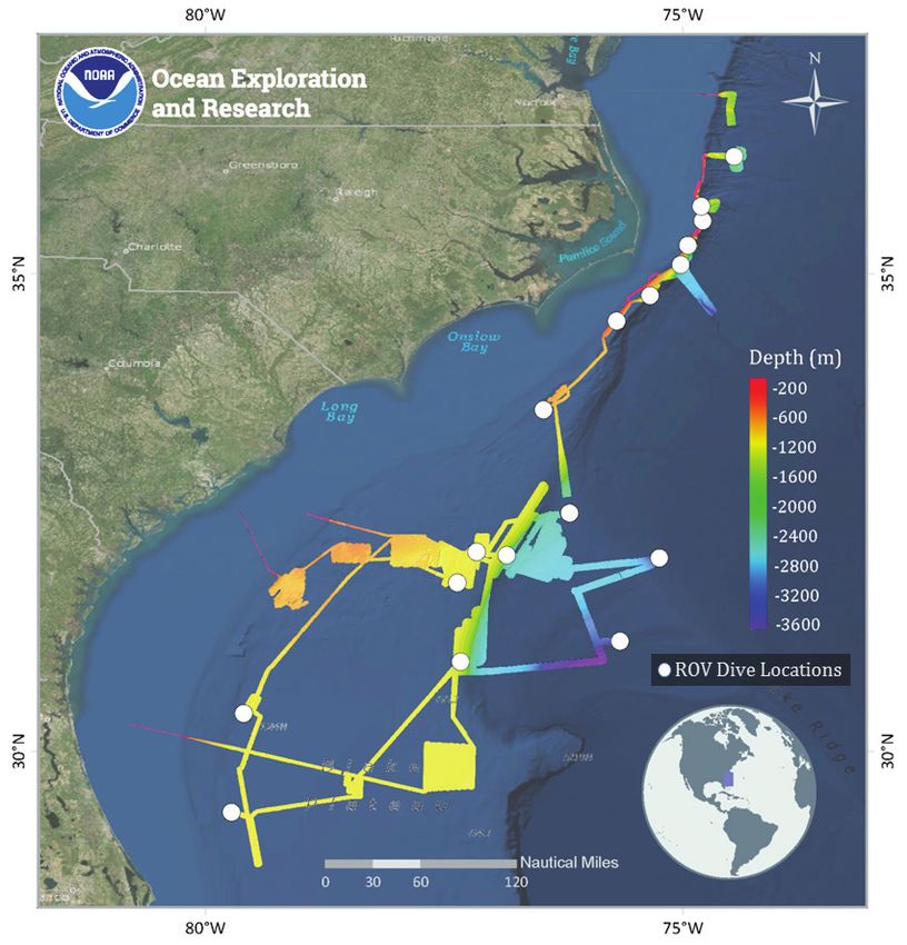


You can also read