WORKING GROUP ON BEAM TRAWL SURVEYS (WGBEAM) - VOLUME 3 | ISSUE 46 ICES SCIENTIFIC REPORTS
←
→
Page content transcription
If your browser does not render page correctly, please read the page content below
WORKING GROUP ON BEAM TRAWL
SURVEYS (WGBEAM)

VOLUME 3 | ISSUE 46
ICES SCIENTIFIC REPORTS

RAPPORTS
SCIENTIFIQUES DU CIEM

                          IC E S   INTERNATIONAL COUNCIL FOR THE EXPLORATION OF THE SEA
                          CIEM     CONSEIL INTERNATIONAL POUR L’EXPLORATION DE LA MER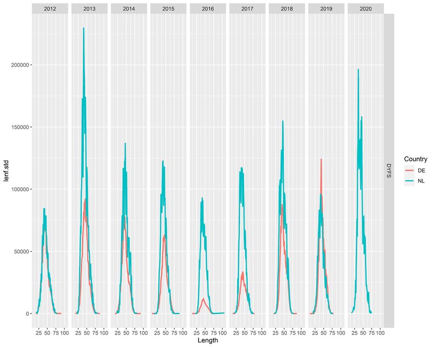
International Council for the Exploration of the Sea
Conseil International pour l’Exploration de la Mer
H.C. Andersens Boulevard 44-46
DK-1553 Copenhagen V
Denmark
Telephone (+45) 33 38 67 00
Telefax (+45) 33 93 42 15
www.ices.dk
info@ices.dk

ISSN number: 2618-1371

This document has been produced under the auspices of an ICES Expert Group or Committee. The
contents therein do not necessarily represent the view of the Council.

© 2021 International Council for the Exploration of the Sea.

This work is licensed under the Creative Commons Attribution 4.0 International License (CC BY 4.0).
For citation of datasets or conditions for use of data to be included in other databases, please refer to
ICES data policy.
ICES Scientific Reports

Volume 3 | Issue 46

WORKING GROUP ON BEAM TRAWL SURVEYS (WGBEAM)

Recommended format for purpose of citation:
ICES. 2021. Working Group on Beam Trawl Surveys (WGBEAM).
ICES Scientific Reports. 3:46. 89pp. https://doi.org/10.17895/ices.pub.8114

Editors
Ingeborg de Boois

Authors
Ingeborg de Boois • Ulrika Beier • Gary Burt • Holger Haslob • Cecilia Kvaavik • Jean-Baptiste Lecomte
Guðjón Már Sigurðsson • Francesco Masnadi • Giuseppe Scarcella • Vaishav Soni • Magnús Thorlacius
 Loes Vandecasteele
ICES   |   WGBEAM 2021                                                                                                                                                |   i

           Contents
           i      Executive summary ....................................................................................................................... ii
           ii     Expert group information ..............................................................................................................iii
           1      General information ....................................................................................................................... i
           2      Survey results (ToR a, b, d, f, i) ...................................................................................................... 2
                  Survey achievements 2020 (ToR f) ................................................................................................ 2
                  Data transmission to DATRAS (ToR d) ........................................................................................... 3
                  Survey indices (Tor a, b, i).............................................................................................................. 4
           3      Survey coordination and standardisation (ToR e, g, h) ................................................................. 7
                  Offshore and inshore beam trawl survey planning 2021 and comparative tows (ToR e) ............. 7
                  Manuals (ToR g, h) ......................................................................................................................... 7
           4      Evaluation of combined survey data (ToR a, b, c) ......................................................................... 8
                  Consistency analyses offshore and inshore beam trawl surveys .................................................. 8
                  (i)      Regional evaluation of offshore and inshore data from DATRAS ......................... 8
                  a.       Calculation of swept area ................................................................................................ 8
                  b.       Example: the evaluation of brown shrimp (Crangon crangon) catches from the
                           inshore surveys (DYFS) in the North Sea. ......................................................................... 9
                  (ii)     Species consistency check across surveys .................................................................. 9
                  a.       Spatial species identification consistency ........................................................................ 9
                  b.       Temporal new species identification consistency ........................................................... 9
           5      Other topics ................................................................................................................................. 11
                  DATRAS developments ................................................................................................................ 11
                  WGBEAM Feedback to ICES DATRAS team.................................................................................. 12
                  Requests for new DATRAS developments ................................................................................... 13
                  Industry surveys .......................................................................................................................... 13
                  Quality assurance ........................................................................................................................ 14
                  Presentations by data end-users ................................................................................................. 14
           6      References ................................................................................................................................... 15
           Annex 1:        List of participants.......................................................................................................... 16
           Annex 2:        Resolutions .................................................................................................................... 17
           Annex 3:        Actions ........................................................................................................................... 20
           Annex 4:        Deadlines for data delivery to DATRAS .......................................................................... 21
           Annex 5:        Survey summary sheets 2020 ........................................................................................ 23
           Annex 6:        Survey planning 2021 ..................................................................................................... 39
                  a.       Timing of the offshore beam trawl surveys in 2021. ..................................................... 39
                  b.       Timing of the inshore beam trawl surveys in 2021. ....................................................... 40
           Annex 7:        Survey indices ................................................................................................................ 41
                  Annex 7.1 Offshore surveys ......................................................................................................... 41
                  Annex 7.1.1 Figures and tables offshore indices sole.................................................................. 46
                  Annex 7.1.2 Figures and tables offshore indices plaice............................................................... 55
                  Annex 7.2 Inshore surveys........................................................................................................... 68
                  Annex 7.2.1 Figures and tables inshore indices sole ................................................................... 70
                  Annex 7.2.2 Figures and tables inshore indices plaice ................................................................ 74
           Annex 8:        Results consistency analyses DATRAS BTS, SNS and DYFS data ..................................... 78
                  Annex 8.1: Regional evaluation of offshore and inshore data from DATRAS, shrimp
                           example.......................................................................................................................... 78
                  Annex 8.2: Species consistency ................................................................................................... 85
           Annex 9:        Information on inshore beam trawl surveys .................................................................. 87
           Annex 10:       Table of contents Manual on inshore beam trawl surveys ............................................ 89
ii   |   ICES SCIENTIFIC REPORTS 3:46                                                                           |   ICES

     i Executive summary

         The Working Group on Beam Trawl Surveys (WGBEAM) coordinates and implements European
         inshore and offshore beam trawl surveys, including planning, standardization, data
         transmission and data quality assurance. The group also coordinates the
         Italian/Croatian/Slovenian beam trawl survey in the Adriatic Sea as there is no other body in the
         EU coordinating beam trawl surveys, and the EU Data Collection Framework requires survey
         coordination.
         In 2020 eleven beam trawl surveys were planned, covering the North Sea, 5a, 7d, 7e, 7fg, 7a, 8a,
         8b and the Northern Adriatic Sea. Despite the COVID-19 pandemic most surveys could be car-
         ried out according to schedule, but often with less staff, only 7a has not been sampled. All data
         have been transmitted to the ICES Database of Trawl Surveys (DATRAS).
         In 2021, a combined session with North Sea and Celtic Sea stock coordinators took place where
         all surveys were presented. Stock coordinators discussed developments in data use and pro-
         vided an overview of current beam trawl survey data use in the assessments.
         The 2018 cohort for sole (Solea solea) and plaice (Pleuronectes platessa) in the North Sea and 7d is
         still visible as 2-year olds in the 2020 beam trawl surveys. No additional strong year classes could
         be seen for sole and plaice.
         R scripts to evaluate the combined offshore and inshore beam trawl surveys data by region and
         cross-regionally have been further developed, and a preferred calculation method for swept area
         has been created.
         The manual for the offshore beam trawl surveys has been updated (full update foreseen in 2023),
         and the manual for the inshore beam trawl surveys has been further developed (first version
         expected mid 2022).
         WGBEAM has also decided to maintain an overview of the current and future industry beam
         trawl surveys.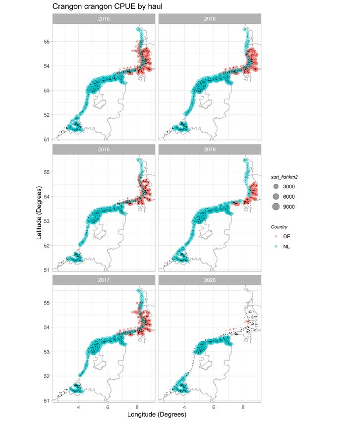
ICES   |   WGBEAM 2021                                                                                    |   iii

       ii Expert group information

           Expert group name            Working Group on Beam Trawl Surveys (WGBEAM)

           Expert group cycle           Multiannual

           Year cycle started           2020

           Reporting year in cycle      2/3

           Chair(s)                     Ingeborg de Boois, the Netherlands

           Meeting venue(s) and dates   23-25 March 2020, webmeeting (due to COVID-19), 13 participants

                                        22-26 March 2021, webmeeting (due to COVID-19), 14 participants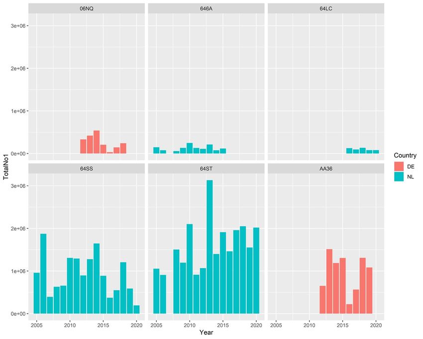
ICES   |   WGBEAM 2021                                                                                           |   1

       1 General information

           Participation
           Due to the COVID-19 pandemic the meeting took place as a web meeting. 14 participants joined
           the meeting (Annex 1), from 8 countries. On Tuesday, five stock coordinators for the relevant
           flatfish and elasmobranch stocks participated in a joint session.

           Meeting goals
           The group’s terms of reference (Annex 2) relate mostly to the role of the group, i.e. to coordinate
           beam trawl surveys in the ICES area, including planning, standardisation, data transmission and
           data quality assurance. The group also coordinates the Italian/Croatian/Slovenian beam trawl
           survey in the Adriatic Sea as there is no other body in the EU coordinating beam trawl surveys,
           and the EU Data Collection Framework requires survey coordination.
           For 2021, the specific tasks were:
           1.   Compilation of survey summary sheets
           2.   Provide tabular overview of survey planning, including geographical areas for overlapping
                tows
           3.   To upload data for all beam trawl surveys (inshore and offshore) including litter in DATRAS
                for at least the last two years, as far as DATRAS allows the survey data to be submitted. For
                datasets where index calculation is done directly from DATRAS, as many years of the time-
                series should be uploaded as is feasible.
           4.   Develop R scripts for and results from the data evaluation by region as well as across regions
           5.   To provide a draft of an inshore beam trawl survey manual following the outlines of SISP 14
           6.   If relevant, to provide updated SISP 14 at the WGBEAM sharepoint (full update in 2022)

           Follow-up of recommendations
           Recommendations 2020 ID 26, 35, 36, 37 from WGBEAM 2020 and 2019 to other recipients have
           been communicated. Recommendation 2020 26 (organising GitHub training) has been com-
           pleted. The updates on 2020 36 and 37 are under chapter Recommendation 2020 ID 46 from
           WGNSSK to WGBEAM and IBTSWG has been taken into consideration by WGBEAM 2021, by
           inviting the relevant stock assessors to the presentation session on the 2020 achievements.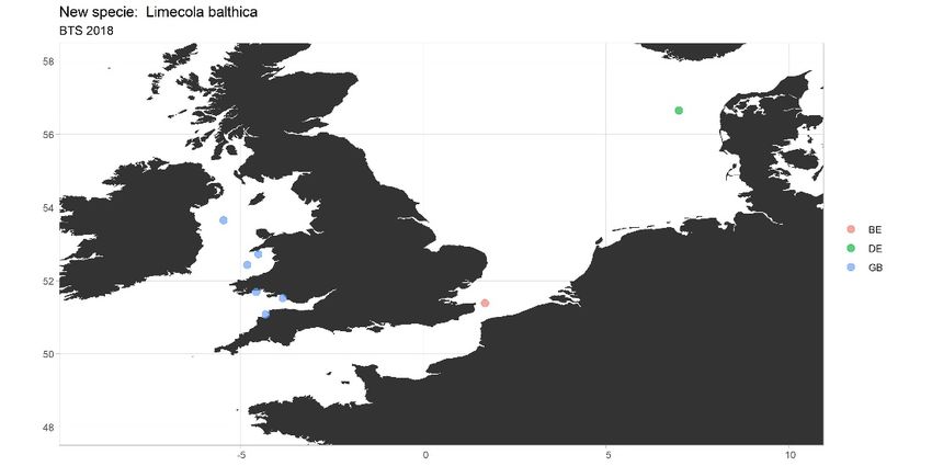
2   |   ICES SCIENTIFIC REPORTS 3:46                                                                                    |   ICES

    2 Survey results (ToR a, b, d, f, i)

        Survey achievements 2020 (ToR f)
        For the offshore and the inshore surveys survey summary sheets (Annex 5) have been prepared,
        containing the main data end-users for fish stock assessment, data collected during the survey,
        and specific comments on the 2020 surveys.
        Offshore surveys
        Eleven surveys were carried out, covering the North Sea, 5a, 7d, 7e, 7fg, 7a, 8a, 8b and the North-
        ern Adriatic Sea. The participating vessels and time of the surveys are listed in Table 2.1. Further
        details (areas covered, technical specifications) by country are given in Annex 5.
        •      The UK Q1SWBEAM survey was -due to COVID-19- moved from March/April to June, and
               shortened to two weeks. As a result, it was not possible to sample the Celtic Sea part of the
               survey, but all planed Western Channel stations were sampled. It has been delivered to
               DATRAS as a ‘Q1 survey’
        •      UK 7fg, 7a NWGFS: a positive COVID-19 test at the start of the survey delayed the survey
               with 14 days and left limited time for its remainder (9 days including steaming time-5 days
               of fishing). As a consequence, a selection of stations has been sampled, only in 7fg. The back-
               ground of the choice was pragmatic, as it was the only manner to complete a significant part
               of the survey.
        •      The Dutch and German survey have been carried out with a limited number of staff due to
               COVID-19 (no students allowed on board), despite that all stations could be sampled. It was
               chosen to only take experienced staff on board.
        •      Due to bad weather conditions, during the Belgian survey some stations were cancelled and
               many were fished for 15 minutes instead of 30 minutes.
        •      The Italian/Slovenian/ Croatian SoleMon survey could not cover the stations Croatian waters
               due to COVID-19 and administrative limitations. Number of staff was reduced due to
               COVID-19.
        Table 2.1. Overview of offshore beam trawl surveys during 2020.

                 Country                Vessel                 Area                     Dates               Gear

            Belgium           Belgica                western-southern North     24 Aug – 04 Sept 2020   4 m beam
                                                     Sea
            France            Côtes de la Manche     8a, 8b                     09 Nov – 03 Dec 2020    4 m beam
            Germany           Solea                  German Bight               24 Aug – 08 Sept 2020   7 m beam
            Iceland           Bjarni Saemundsson     Entire coast of Iceland    26 Aug – 11 Sept 2020   4 m beam
            Italy/ Slovenia   G. Dallaporta          Northern Adriatic Sea      01 Dec – 16 Dec 2020    2x 3.5m modi-
                                                     (GSA 17)                                           fied beam
            Netherlands       Tridens                southern North Sea, Ger-   27 Jul–14 Aug 2020      2x 8 m beam
                                                     man Bight
            Netherlands       Tridens                central and western        17 Aug–11 Sep 2020      2x 8 m beam +
                                                     North Sea                                          flip-up rope
            UK                Cefas Endeavour        English Channel /Celtic    14–28 Jun 2020          4 m beam
                                                     Sea
            UK                Cefas Endeavour        7d, 4c                     13 – 25 Jul 2020        4 m beam

            UK                Cefas Endeavour        7fg, 7a                    20 – 30 Sept 2020       4 m beam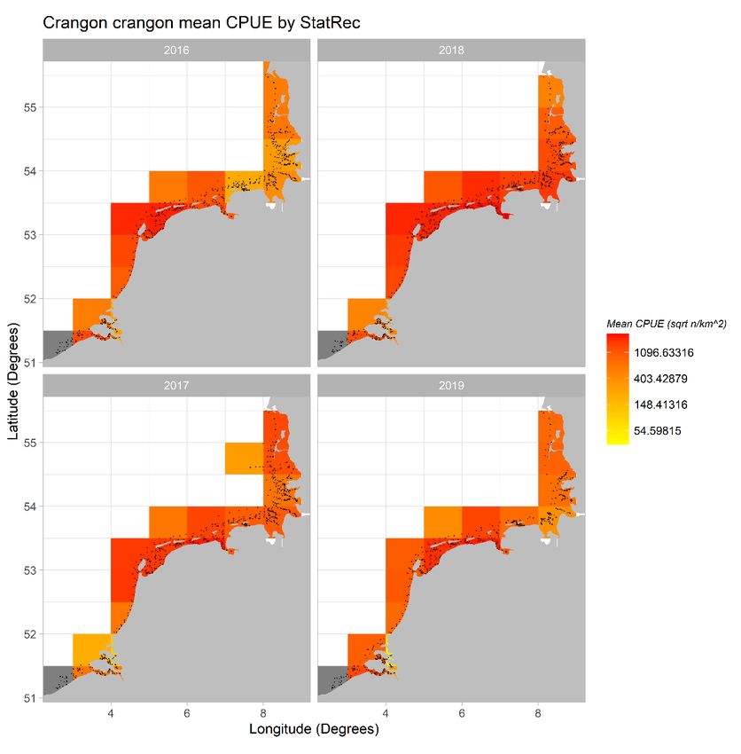
ICES   |   WGBEAM 2021                                                                                             |   3

           Inshore surveys
           The inshore surveys in the North Sea are carried out by Belgium (Demersal Young Fish Survey-
           DYFS), Germany (DYFS) and the Netherlands (Demersal Fish Survey-DFS). UK (Young Fish Sur-
           vey-YFS) ceased the survey due financial constraints in 2012.
           The Sole Net Survey (SNS), which is carried out by the Netherlands in the North Sea, is classified
           as an inshore survey, but ‘nearshore’ may be more appropriate because the area covered is fur-
           ther offshore than the other inshore surveys.
           The participating vessels and time of the cruises are listed in Table 2.2. Details on the surveys are
           given in Annex 9. Details on the 2020 survey achievements are in Annex 7.
           •   The Dutch SNS survey started with one week delay due to technical issues and weather
               conditions. As a result, the survey in the Dutch coastal zone (DYFS) was also postponed by
               one week.
           •   The Dutch DYFS in the Wadden Sea was carried out with only one WMR staff member due
               to COVID-19 restrictions. The ship’s crew assisted with the sampling.
           •   The German DYFS was carried out as planned and there were no restrictions because of
               COVID-19. One day in the North Frisian was cancelled because of bad weather condition
               but the full spatial coverage of the survey was achieved.
           •   The Belgian DYFS suffers from tight ship’s planning, and the priority given to ‘scientific pro-
               jects’ (i.e. University projects). In 2020 no technical issues arose and the weather was fine, so
               the survey could be fully carried out. WGBEAM points out that for future, it is a point of
               concern.
            Table 2.2. Overview of surveys during 2020.

           Country         Vessel                   Area                   Dates                Gear
           Belgium         Simon Stevin             Belgian coastal zone   14 – 23 Sept 2020    6 m shrimp trawl
           Germany         Chartered vessels         German Wadden Sea     21 Aug – 23 Sep0 Oct 3 m shrimp trawl
           (DYFS)                                                          2020
           Germany         RV Clupea                German Bight coastal   13 Sep – 05 Oct 2020 3m Shrimp trawl
           (DYFS)                                   zone
           Netherlands     Isis                     Dutch coastal zone     9-25 Sep 2020        6 m beam trawl
           (SNS)
           Netherlands     Luctor                   Scheldt estuary        31 Aug–18 Sep 2020   3 m shrimp trawl
           (DYFS)
           Netherlands     Stern                    Dutch Wadden Sea       24 Aug–25 Sep 2020   3 m shrimp trawl
           (DYFS)
           Netherlands     Isis                     Dutch coastal zone and 28 Sep–30 Oct 2020   6 m shrimp trawl
           (DYFS)                                   German Bight

           Data transmission to DATRAS (ToR d)
           (1) Evaluate achievable deadlines for data delivery
           In 2020, WGBEAM proposed new data delivery deadlines for beam trawl survey data submis-
           sion to DATRAS. Apart from some specific issues related to the COVID-19 pandemic, all dead-
           lines could be met and there is no reason to change those set in WGBEAM 2020. The deadlines
           for submission of the 2021 beam trawl survey results are in Annex 4.

           (2) Coordinate and evaluate data delivery to DATRAS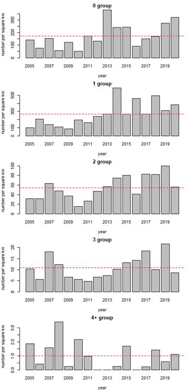
4 | ICES SCIENTIFIC REPORTS 3:46 | ICES
Fish trawl data
Unaggregated beam trawl data are stored in DATRAS up and until the survey of the year previ-
ous to the meeting year. For 2020 all countries managed to upload their data to DATRAS prior
to the meeting. These data are available in the database, but not all of them are already available
for download in exchange format. A full overview of the DATRAS submission status is available
at https://datras.ices.dk/Data_products/Submission_Status.aspx (select one of the Beam Trawl
Surveys, Inshore beam trawl survey or Sole Net Survey).
Exceptions in data submission:
• For the offshore beam trawl surveys, only the Icelandic survey data are not delivered, as
DATRAS does not allow for that data yet.
• For the inshore surveys, the 2020 German age data are not complete yet due to COVID-19
logistic issues. Final submission is scheduled for April 2021.
Marine litter
Data on bycatches of marine litter are also stored in the DATRAS database. In the offshore beam
trawl surveys (BTS) in the North Sea litter is being registered and submitted to DATRAS on a
regular basis. Litter data from the English BTS surveys are regularly added for western Channel
and Celtic Sea (Q1), North sea and eastern Channel (Q3), Irish Sea and Bristol Channel (Q3).
Exceptions in data submission:
• Belgian BTS and DYFS litter data have not been submitted yet for 2020, as the aim is to up-
load the data within the year after the survey.
Blocked time frames for resubmission of data to DATRAS
In order to provide the stock coordinators sufficient time to prepare their input for the stock
assessment groups, some closure times for resubmission of files to DATRAS have been agreed
upon (Table 2.3, Annex 4.3), unless induced by the end-user.
Table 2.3. Overview of open (green) and closed (grey marked with X) periods for resubmission of data to DATRAS.
Region Jan Feb Mar Apr May Jun Jul Aug Sep Oct Nov Dec
Greater North Sea X X X
7d X X X
7a, fg X X X
Bay of Biscay X X
Adriatic Sea X X X
Icelandic Sea X X X
Survey indices (Tor a, b, i)
The full text and figures for the index series are in Annex 7.
North Sea – Subarea 4
For sole (offshore text Annex 7.1, figures Annex 7.1.1 7.1.1-7.1.4; inshore text Annex 7.2, figures
Annex 7.2.1) strong 2016 and 2018 yearclasses can be tracked in multiple surveys (offshore and
inshore). Depending on the exact survey area, the cohort consistency is stronger. For sole the
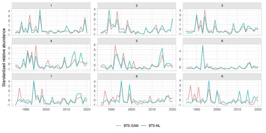
strong 2018 cohort is visible in 2020 in both the offshore (BTS) and the inshore (SNS) surveys. For
sole a benchmark has taken place in 2020 and since spring 2020 the NL 1985-2020, DE 1993-2020,ICES | WGBEAM 2021 | 5
BE 2004-2020 offshore beam trawl survey data south of 57°30’are taken into account, as a swept-
area based index series, next to the SNS series and the DYFS recruit series.
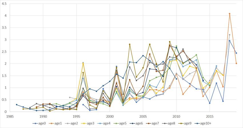
For plaice (offshore text Annex 7.1, figures Annex 7.1.2.1-7.1.2.6; inshore text Annex 7.2, figures
Annex 7.2.2) the strong 2018 yearclass is still present as 2-years old. From the Dutch offshore
survey in the western and central North Sea (Figure 7.1.2.3) it seems that older age groups have
disappeared from the survey area. It is in line with the field observation that less larger plaice
have been caught during the 2019 and 2020 survey. In 2018, 2019 and 2020 the decreased mean
length may have been influenced by extreme recruitment (2018 yearclass).
Western waters-subarea 7 and 8
Sole (text Annex 7.1.1, figures 7.1.5–7.1.7) as well as plaice (text Annex 7.1.1, figures 7.2.7–7.2.9)
from area 7 stocks develops differently between the areas.
7d
The year-class pattern in division 7d overlaps strongly with those in subarea 4 for both sole and
plaice. Cohorts can be generally well tracked between years in this survey.
7f
In 2020, all planned Division 7f stations were successfully completed despite a delay to the start
of the survey following a COVID-19 positive test (Section 2, Annex 5).
In division 7f the abundance of age 1 sole at first glance appears to have been rather stable across
the time-series with one very large cohort observed in 1999, and another strong cohort in2017.
Due to the large contrast the survey has been able to track both cohorts well through its existence.
For plaice the survey index is highly informative on long-term stock dynamic trends but esti-
mates of individual cohort abundance are not necessarily tracked that well in all but the smallest
and largest cohorts. Some age-based models may confuse these signals with rapid selectivity
changes in the fleet. Particularly age-1 abundance seems to be affected by this which may be
linked to variable rates of unintended fishing mortality in the area.
7a
In 2020 no survey took place in Division 7a, due to delay by a COVID-19 positive test at the start
of the survey (Section 2, Annex 5).
Sole in division 7a has in recent years been of concern to managers due to low SSB values. The
most recent survey trends indicate that following the strong decrease in sole abundance at age 1
until 2014 is starting to reverse with higher recruitment rates being observed since then.
In contrast to the sole stock the 7a plaice stock seems to be in a very healthy condition, although
the reduction in recent recruitment indicates that it is unlikely that the recent period of high
productivity may not be maintained. A change in productivity might be indicative of some
changes to the ecosystem relevant to plaice reproduction and that historic levels of catches ap-
plied to the current stock would require further analysis to ensure that they would remain sus-
tainable.
8
There is no evidence of the synchrony in recruitment pattern observed between division 8 (text
Annex 7.1.1, figure 7.1.1.8) and divisions 7a and 7f. Since 2018, the time-series of age group abun-
dances of sole are marked by 1-group recruitments below average. There is good cohort tracking
of abundance estimates from age 1 to 3. Full selectivity appears to be reached at age 2.
Northern Adriatic Sea6 | ICES SCIENTIFIC REPORTS 3:46 | ICES
Overall an increasing trend for all the ages in the second part on the time-series is visible (text
Annex 7.1.1, Figure 7.1.1.9). In particular the high recruitment observed in 2013 can be followed
in the succeeding years. Moreover the 2019 and 2020 seem to be good years for recruitment.
Icelandic Sea
The 2020 survey values for plaice mostly show similar values as in 2017 and 2018 (text Annex
7.1.2, Figure 7.1.2.10). The 2019 survey indicated that almost all the age groups (except for age 9)
were lower than the long-term arithmetic mean, most likely due to it being conducted earlier in
summer than in the other years. The internal consistency of the series is weak in the younger
ages but becomes relatively good starting from age group 4, in particular the high value observed
in 2016 can be followed in the succeeding years.ICES | WGBEAM 2021 | 7
3 Survey coordination and standardisation (ToR e, g,
h)
Offshore and inshore beam trawl survey planning 2021 and comparative
tows (ToR e)
The survey planning for the offshore and inshore beam trawl surveys 2021 is largely in line with
previous years. Annex 6 contains the detailed planning.
As in previous years, WGBEAM recommends that if time and weather allows, overlapping hauls
should be carried out by countries operating in the same area.
During the Dutch and German surveys in the North Sea, some overlapping hauls should be at-
tempted in the following rectangles, like in 2020: 40F4, 40F5, 40F6, 41F4, 41F5, 41F6, 42F4, 42F5,
42F6, 43F4, 43F5, 43F6. The responsible scientists will contact each other approx. one month be-
fore the start of the Dutch survey to make appointments on the execution of the comparative
tows. Comparative fishing has always been on the WGBEAM task list, but has become more
important since the index calculation takes into account all beam trawl survey data in the North
Sea with DeltaGAM. The model is more reliable when overlapping tows are available in the
dataseries.
The Belgian and Dutch surveys also include rectangles fished by both in the same time frame,
but the bottom of the Belgian positions is very rough. It is not possible to fish on these locations
with the gear used by The Netherlands.
Northern Adriatic Sea survey, conducted by Italy, could undergo spatial coverage changes as
Croatia established the EEZ in early 2021. This mean that the 7 hauls in Croatian national waters
could undergo changes. In 2021, hauls might not be performed within BTS-GSA17 or performed
by Croatia with an independent survey.
Manuals (ToR g, h)
In 2020, an outline was made for the Manual on inshore beam trawl surveys (table of contents in
Annex 10). The structure is based on the manual on offshore beam trawl surveys SISP 14 (ICES
2019). Intersessional actions have been defined (Annex 3.2). Throughout 2020 and at the
WGBEAM 2021 meeting, further progress has been made. The first version should be available
for internal review on 1st November 2021.
Based on the discussions on methodologies used in the inshore surveys, WGBEAM recommends
that WGCRAN provides the following information:
• WGCRAN’s preferred conservation method of shrimp to be measured (fresh, frozen, cooked,
ethanol, etc.) for the DYFS;
• WGCRAN’s view on the minimum number of measurements on shrimp per stratum (i.e.,
subarea) for a reliable assessment in the DYFS.
Based on the information, WGBEAM can then evaluate the current survey setup, including the
current amount of measurements, and see if improvements in the procedures are achievable.
The Manual on offshore beam trawl surveys (ICES 2019) has been updated where necessary. The
compy is stored on the WGBEAM sharepoint. The updated manual will be made available in
year 3 of the cycle (2022).8 | ICES SCIENTIFIC REPORTS 3:46 | ICES
4 Evaluation of combined survey data (ToR a, b, c)
Consistency analyses offshore and inshore beam trawl surveys
WGBEAM subgroups evaluated offshore and inshore data from DATRAS. The R scripts pro-
duced can be used to evaluate any beam trawl survey (BTS, DYFS, SNS) and any species in
DATRAS. The R scripts have been stored at https://github.com/ices-eg/wg_WGBEAM.
(i) Regional evaluation of offshore and inshore data from DATRAS
The latest information on DATRAS is extracted by the getDATAS function (icesDatras package).
Haul information (HH) and length information (HL) is combined into one dataset. Simple qual-
ity checks (e.g. tables to explore missing data, checks for NAs) are incorporated in the script.
In the script a species list is created from WoRMS (www.marinespecies.org), so valid Aphia
codes in DATRAS can be linked to the correct scientific names. Before filtering to a specific spe-
cies of interest, a list of the fished stations is created. In this way stations with zero observations
can be taken into account when calculating average values.
In order to calculate CPUEs (preferably in numbers/km² or numbers/1000m²) from the beam
trawl surveys total numbers per haul and the surface area that was fished (=swept area) for each
haul need to be made available. With the script a bar plot can be created to check for the combi-
nations of country, gear and year whether total numbers (TotalNo) are available. If the column
for total numbers is not filled in (NA or -9), total catch numbers can be calculated based on haul
numbers at-length (HLNoAtLngt) multiplied by the subsampling ratio (SubFactor).
a. Calculation of swept area
Swept area can be calculated in different ways. For beam trawl surveys the calculation of the
swept area (SA) is quite straightforward, since the width of the beam does not change and
the gear more or less follows the surface of the seafloor. However, swept area is sometimes
calculated in different ways. Two options are suggested by WGBEAM:
For conditions where GearExp=SB (single beam; catch of one net sorted):
1) Swept area in km² = beam width * distance / 106
2) Swept area in km² = beam width *(haul duration/60)*fishing speed*1852/106
3) Calculate distance based on shooting and hauling position (formula available at ICES
Data Centre), and apply calculated distance in formula 1)
For conditions where GearExp=DB (double beam; catches of two nets put together):
1) Swept area in km² = 2*beam width * distance / 106
2) Swept area in km² = 2*beam width *(haul duration/60)*fishing speed*1852/106
3) Calculate distance based on shooting and hauling position (formula available at ICES
Data Centre), and apply calculated distance in formula 1)
Where (Italics=reference to DATRAS product terminology):
• beam width: numerical value in Gear (in meters)
• distance: Distance (in meters)
• haul duration: HaulDur (in minutes)
• fishing speed: GroundSpeed (in knots)
• shooting position: ShootLat, ShootLong
• hauling position: HaulLat, HaulLongICES | WGBEAM 2021 | 9
WGBEAM advises to always use option 1 based on beam width and distance, except when
the distance is missing from DATRAS, then option 2 is the best alternative. Haul duration
should always be between 5 and 40 minutes, except for incidental cases for the Netherlands
(caused by sorting two nets at the same time; this will in 2021 be changed into GearExp=DB).
Fishing speed differs depending on the survey and vessel that was used. The fishing speed
for the all of the beam trawl surveys under coordination of WGBEAM can be found in the
WGBEAM manual (ICES, 2019). When fishing speed is missing in DATRAS, the standard
values reported in the manual can be taken as the average fishing speed, or calculation op-
tion 3 could be used (depending on the availability of information).
b. Example: the evaluation of brown shrimp (Crangon crangon) catches from the
inshore surveys (DYFS) in the North Sea.
As an example the script was run to evaluate all DYFS surveys in DATRAS for the years
2004-2020. The focus species was shrimp. The trends for Germany and the Netherlands are
similar, although the Dutch DYFS consistently seems to catch more shrimp. This may have
to do with the catchability of the gear or with the spatial distribution of the shrimp. A full
description of the example settings and the script output can be found in Annex 8.1.
(ii) Species consistency check across surveys
a. Spatial species identification consistency
In order to evaluate if species are recorded in a consistent way across surveys, the R script
developed under (i) was modified and extended. DATRAS data were extracted and tabu-
lated by overlapping survey areas to identify possible differences in species identification.
One first result of this exercise was that obviously there exist some inconsistencies between
the SpecVal numbers uploaded and the ValidAphiaID from WoRMS
(http://www.marinespecies.org/). This was communicated to ICES Data centre and will be
checked. In a second step, BTS Data from 2018 (North Sea) were tabulated and data from
areas where survey activities overlap were checked in detail by a subgroup. There were no
major inconsistencies spotted and it seems that the identification of species was consistent
between surveys (NL, DE, BE, GB; Annex 8.2: Table 8.2.1, Figure 8.2.1). There are some dif-
ferences in the general approach of recording species, i.e. which organisms beside fish and
macro-epibenthos are recorded (e.g. jellies) or the identification level for more difficult spe-
cies (e.g. Ammodytes). It is clear that it is not possible to identify all inconsistencies in species
recording across surveys with such simple tables. However, it was concluded by the group
that it will facilitate the evaluation of species recording consistency from year to year within
WGBEAM. Another function included into the script was a check for new species recorded.
This at least will give a hint if there is an error or there was really a new species encountered
with the survey. This functionality already exists in DATRAS internal data checks but it is
so far not listed in the warnings returned by the upload tool. It was discussed that this might
be implemented in the future. The script for species consistency check will be further devel-
oped and discussed within WGBEAM.
b. Temporal new species identification consistency
In order to evaluate temporal new species identification consistency across the survey, the R
script developed under (i) and (iia) was modified and extended. The script allowed to extract
DATRAS data time-series (user can define period and survey to analyse; e.g. 2000-2018 BTS
data) and to easily find the first year of appearance of all species in the series. After extraction
of the table, one can select a specific year to view the list of species appearing in that specific
survey year. To see if and which new species have been found in a specific survey compared
to the previous year, the user needs to select only those two years.10 | ICES SCIENTIFIC REPORTS 3:46 | ICES
The same analyses can be conducted in more details by country. A pie chart provides a sim-
ple overview of the percentage of new species by country in a specific year (Annex 8.2: Figure
8.2.2). Looking at the list by country allows WGBEAM to check if good consistency in new
species identification is present in all survey areas.
Moreover, the script allows the user to produce maps of new species occurrence for a specific
year to see in which area/areas the species was found. In the example (Annex 8.2: Figure
8.2.3), a new species Limecola balthica was found by three different country in 2018 survey. In
particular, the species was found by DE in the North Sea near Denmark, by BE near the
English Channel and by GB in Bristol Channel and in the Irish Sea. This spatial output can
help survey coordinators to have better information of possible species finding in future sur-
vey. The script can be found and downloaded on the specific WGBEAM Github page
(https://github.com/ices-eg/wg_WGBEAM/blob/master/New_Species_consistency.R).ICES | WGBEAM 2021 | 11
5 Other topics
DATRAS developments
The recent and upcoming DATRAS developments have been presented by the ICES DATRAS
team. Those included:
a. Unified format fields: the status of the new unified format fields is that some are used in BTS
and some are not, and this varies between countries, especially for HH and HL records. For
almost all beam trawl surveys the new fields in CA are used.
b. The use of headers for the HH, HL and CA data file will be compulsory from 2021 Q4: In
2020 headers for each record type were introduced. Headers will provide flexibility in the
submission of non-mandatory information, as submitters can leave out headers for which
they don’t provide information. In 2020 all submitters have been asked to submit their files
with header line. The screening program also checks the header text next to the data column
value checking. In 2020 and 2021 it is allowed to submit data with or without headers. From
Q4 2021 onwards all data submitted to DATRAS need have headers otherwise it will not
pass from screening program.
c. DevStage check in DATRAS: currently DATRAS does not allow submission of two values of
Devstage for the same species, sex and haul. A check will be added into the procedure to be
able to include this vocabulary in the submitted data (https://vocab.ices.dk/?ref=1397).
d. Swept area calculation for SNS, DYFS, BTS-VIII: DATRAS has implemented swept are cal-
culation for SNS, DYFS and BTS-VIII. Originally the BTS logic is used for the calculation
procedure. Although the BTS swept area product was examined and used by data users, the
DATRAS team asked to WGBEAM to examine the result for new products and verify with
theirs calculation methods (response in “WGBEAM Feedback to ICES DATRAS team”). The
DATRAS in the process of calculating swept area product for Adriatic survey and result will
be share with the group member for verification.
e. Distance cross-check: as distance is one of the major parameter for the swept area calculation
it is essential to implement an additional check on distance in the DATRAS checking pro-
gram. The current check warn when the difference between distance and calculated distance
is more than 300 meter. The new check should give more assurance to the end user on the
distance field. The DATRAS team proposes that new check will be implemented using use
the speed as reported in the submitted file and haul duration parameter to estimate distance
and raise a warning if the reported distance value is out of the range.
f. Survey codes: the current survey naming varies and is often not consistence between report,
stock annex and advice sheets, so a new survey coding is proposed (controlled vocabulary).
The survey code is a one-letter prefix (describing survey type) and a running number. In the
end there will be a direct link between sock annexes, advice sheets and survey groups.
WGBEAM response and discussion in “WGBEAM Feedback to ICES DATRAS team”.
g. A question was raised regarding that the survey group felt that it was to confined to have
ICES stock codes linked to surveys, since these are multispecies surveys and should reflect
that in the coding. Also, each country is targeting and catching different species, this they
also think should be reflected in the survey code. Therefore, an addition to the list was made,
where each country can fill in information regarding the fields currently in the survey code
to elaborate on area and species. They also found that having some connection to what sort
of data were collected from the surveys would be beneficial for the end product.
h. DATRAS dataflow chart: a flow chart has been developed for DATRAS data. WGBEAM re-
sponse and discussion in “WGBEAM Feedback to ICES DATRAS team”.12 | ICES SCIENTIFIC REPORTS 3:46 | ICES
i. GitHub Training: like in 2020, ICES Datacentre has offered to host a joint DATRAS GitHub
training in 2021 for survey groups. Contact DATRAS administration (DatrasAdministra-
tion@ices.dk).
WGBEAM Feedback to ICES DATRAS team
WGBEAM provided feedback by ICES DATRAS Team on the following topics:
• Completing the survey code list for the beam trawl surveys: the survey group wondered that
it was to confined to have ICES stock codes linked to surveys, since these are multispecies
surveys and should reflect that in the coding. Also, each country is targeting and catching
different species, this they also think should be reflected in the survey code. Therefore, an
addition to the list was made, where each country can fill in information regarding the fields
currently in the survey code to elaborate on area and species. They also found that having
some connection to what sort of data were collected from the surveys would be beneficial
for the end product.
• The proposed data flow description: the data flow has been evaluated by a subgroup. Main
points of attention were:
o The flow now implies that assessments are peer-reviewed by a group. The output
from assessment group is reviewed by the advice drafting group, but the assessment
itself not;
o It is unclear if the flow is only aiming at the fish stock assessment process, or also
considers a wider scope such as ecosystem assessments. In that case, also external
partners may have to be taken into consideration, like OSPAR and HELCOM;
o Although the flow describes the current transfer of data from survey group to as-
sessment group correctly, it is important to realise that a clear feedback loop on the
outcomes of the benchmark process to the survey groups.
• The proposed swept-area DATRAS product for BTS-VIII, SNS and DYFS:
o The BTS-VIII product has been reviewed, and the calculation seems to be in line with
the expectation;
o The DYFS and SNS products contain a number of aphiaID codes with two different
species names connected to it, sometimes even within the same survey, year and
haul, for example:
NL DYFS & SNS 2018-2020: 105814, 126425, 126927, 127147, 127149, 127160,
127262, 150630, 153131, 293624
Evaluation of the DYFS 2002-2020 revealed aphiaID codes not leading to a
valid aphiaID: 235, 801, 106964, 106925, 137084, 137734, 138439, 139908,
144296, 152367, 405451, 428647, 587704, 836033
WGBEAM recommends that ICES Data Centre reviews the mapping of the aphiaIDs
with species names, not only for the newly developed products, but also for the ex-
isting CPUE products. The species name in the product should always be the valid
species name as available in www.marinespecies.org, and a valid aphiaID should
always be available in the file.
o The comparison for NE DYFS and SNS 2018-2020 was carried out comparing the
proposed data product with the standard calculation done directly from the Dutch
database for measured specimens and resulted in:
No differences in numbers per haul;
One discrepancy on the swept area calculation, caused by rounding (368.93
vs 368.94 fish per km2);
No discrepancies on the calculation of numbers per hour.ICES | WGBEAM 2021 | 13
The data taken into account are however only the measured specimens, which re-
sults in only fish data and no CPUE per swept area is calculated for benthos species
other than Crangon crangon. WGBEAM recommends that ICES Data Centre also
takes into account benthos data without lengths in the new products, in line with
the BTS product CPUE_per_length_per_Hour_and_Swept_Area.
• All DYFS and SNS data products: although in the data reporting format the DYFS and
SNS area codes are allowed in HH (in StatRec) as well as in CA (AreaType-AreaCode
combination), the values return as ICES statistical rectangles in the products (Exchange
data nor Swept area). It is therefore impossible to analyse the DYFS and SNS data in the
way they have been collected. WGBEAM recommends that the values entered in StatRec
and AreaType be returned in all data products, so not to apply a calculation to ICES
statistical rectangle. If it is in the eyes of ICES Data Centre preferred to either change the
field name StatRec (HH) into a term that better covers the needs, or to add a field to HH
for area codes not being ICES statistical rectangles, WGBEAM recommends that WGDG
further decides on the way forward.
• With respect to the proposed additional values liver weight and liver parasites (CA),
WGBEAM does not see an issue for incorporation of the field liver weight in the unified
format once only headers are allowed. For parasites and other diseases a separate record
type seems to be a more appropriate choice, as it provides the opportunity to provide
multiple disease registrations for an individual fish.
Requests for new DATRAS developments
WGBEAM noted requirements for further developments of DATRAS and recommends that this
is discussed in WGDG:
• Record methodology of distance (calculated by speed and duration, by ship’s log, by calcu-
lation shoot-haul position, etc.)
• Record conservation status of species: fresh, frozen, cooked, .....
• Although WGBEAM suggests not to add so-called ‘seeded ages’ and upload individual fish
for which no age has been collected with Age=-9, it may be considered to add additional
coding in TS_AgeSource, e.g. ‘estimate’.
• It appeared that DATRAS does not allow for submission of HH records of valid tows without
HL and/or CA records. WGBEAM concluded that this should be allowed, as valid tows may
occur, but in single-species surveys (stdspecrec=1, bycspecrec=0) it may lead to wrong esti-
mates of average catches if 0-hauls are not taken into account.
Industry surveys
Presentations were given on the achievements of the UK Western Channel Sole and Plaice in-
dustry survey (http://data.cefas.co.uk/#/View/20717), and on the set up of the Netherlands in-
dustry survey on Turbot and Brill (Schram et al., 2021). For the latter survey, the data have been
submitted to DATRAS.
The group discussed if Industry beam trawl surveys should be coordinated by WGBEAM. In
principal, WGBEAM is the natural focal point for any beam trawl survey in the ICES areas of
which the data are used in the stock assessments. It is proposed that presentations on achieve-
ments of the industry surveys are incorporated in the session on last year’s achievements, and
incorporate industry surveys in the survey summary sheets. Although it is not possible to force
anyone to make data publicly available, WGBEAM strongly suggests that this is done, especially
when data will be or are used in stock assessment.14 | ICES SCIENTIFIC REPORTS 3:46 | ICES
Quality assurance
Presentations were given on the outcomes of the age reading workshops for dab and plaice. Age
readings of dab show considerably lower percentage agreement than plaice. For both species no
country-effect could be seen.
The setup of species identification tests and workshops in the Netherlands was presented, for
inspiration (de Boois, 2020). A similar setup is done in Belgium. Based on the experiences, it was
concluded that species identification tests and workshops are an effective way to open the dia-
logue on species recognition, and also clearly shows the expertise of the technicians.
The proposed terms of reference of a follow-up of the Workshop on unavoidable survey effort
reduction (WKUSER-2) have been provided to the group.
Presentations by data end-users
The following topics were presented:
• North Sea sole, implementation of benchmark 2019
• North Sea plaice, the possibility to combine indices -prelim results
• North Sea dab and flounder, current data use in stock assessment
• 7d sole benchmark results
• WKSKATE follow-up actions for beam trawl surveys
• Adriatic Sea sole benchmark
• Planned incorporation of beam trawl survey data in Icelandic Sea
WGBEAM evaluated the combined session, and found it useful as it linked up people and pro-
vided information to the survey group as well as to the stock coordinators. WGBEAM found it
easier to follow-up on questions raised during that session. The stock assessors also appreciated
the opportunity to be informed on the survey’s achievements. It was useful to have many short
presentations, together providing a good overview of the work achieved and the use of data.
Suggestion for improvement:
• Invite all potential stock coordinators for flatfish species: Irish Sea stocks, lemon sole in the
North Sea.ICES | WGBEAM 2021 | 15
6 References
Boois, I.J. de. 2020. Species identification workshop 2020: demersal fish and macro-zoobenthos. Wa-
geningen Marine Research internal report 20.003.
ICES. 2019. Manual for the Offshore Beam Trawl Surveys, Version 3.4, April 2019, Working Group on Beam
Trawl Surveys. 54pp. http://doi.org/10.17895/ices.pub.5353
Schram, E., N. Hintzen, J. Batsleer, T. Wilkes, K. Bleeker, W. van Broekhoven, D. Ras, E. de Boer, B.
Trapman, N. A. Steins. 2021. Industry survey turbot and brill in the North Sea: Set up and results of a
fisheries-independent survey using commercial fishing vessels 2018-2020. Report C037/21
https://doi.org/10.18174/54458816 | ICES SCIENTIFIC REPORTS 3:46 | ICES
Annex 1: List of participants
Name Institute Country (of in- Email
stitute)
Ulrika Beier Wageningen Marine Research Netherlands Ulrika.beier@wur.nl
Ingeborg de Boois Wageningen Marine Research Netherlands Ingeborg.deboois@wur.nl
Gary Burt Centre for Environment UK gary.burt@cefas.co.uk
Fisheries and Aquaculture
Science (Cefas)
Holger Haslob Thuenen-Institute of Sea Fisheries Germany Holger.haslob@thuenen.de
Cecilia Kvaavik ICES Denmark Cecilia.kvaavik@ices.dk
Jean-Baptiste Institut français de recherche pour l'exploita- France Jean.Baptiste.Lecomte@ifremer.fr
Lecomte tion de la mer (IFREMER)
Guðjón Már Sigurðs- Marine and Freshwater Research Institute Iceland gudjon@hafogvatn.is
son
Francesco Masnadi University of Bologna - National Research Italy francesco.masnadi2@unibo.it
Council (CNR)
francesco.masnadi@irbim.cnr.it
Kay Panten Thuenen-Institute of Sea Fisheries Germany kay.panten@thuenen.de
Heleen Raat (partly) Institute for Agricultural, Fisheries and Food Belgium Heleen.raat@ilvo.vlaanderen.be
Research (ILVO)
Giuseppe Scarcella Italian National Research Council | CNR · Insti- Italy giuseppe.scarcella@an.ismar.cnr.it
tute of Marine Science ISMAR
Vaishav Soni ICES Denmark vaishav@ices.dk
Magnús Thorlacius Marine and Freshwater Research Institute Iceland magnus@hafogvatn.is
Loes Vandecasteele Institute for Agricultural, Fisheries and Food Belgium Loes.vandecasteele@ilvo.vlaan-
Research (ILVO) deren.be
Stock coordinators in the joint session
Name Institute Country (of in- Email
stitute)
Jurgen Batsleer Wageningen Marine Research Netherlands Jurgen.batsleer@wur.nl
Chun Chen Wageningen Marine Research Netherlands Chun.chen@wur.nl
Iago Mosqueira Sanchez Wageningen Marine Research Netherlands iago.mosqueira@wur.nl
Lies Vansteenbrugge Institute for Agricultural, Fisheries and Belgium Lies.vansteenbrugge@ilvo.vlaan-
Food Research (ILVO) deren.beICES | WGBEAM 2021 | 17
Annex 2: Resolutions
WGBEAM – Working Group on Beam Trawl Surveys
2019/FT/EOSG10 A Working Group on Beam Trawl Surveys (WGBEAM), chaired
by Ingeborg de Boois*, the Netherlands, will work on ToRs and generate deliverables as listed in
the Table below.
M EETING DATES V ENUE R EPORTING DETAILS C OMMENTS ( CHANGE IN CHAIR ,
ETC .)
Year 1 24-27 March Reykjavik, The first interim report by 30 Incoming Chair: Ingeborg de
2020 Iceland April 2020 to SCICOM and Boois
ACOM
(meeting took place online)
Year 2 2021 Reykjavik,
The second interim report by 30 (meeting took place online)
Iceland
April 2021 to SCICOM and
ACOM
Year 3 2022 Reykjavik,
Final report by XX YYYY 20XX
Iceland
to SCICOM and ACOM
ToR descriptors 1
TOR B ACKGROUND S CIENCED URATIONE XPECTED D ELIVERABLES
D ESCRIPTION PLAN
CODES
a Evaluate the combined offshore and Evaluation by region will 3.1, 3.2 annually (a) Updated, consistent and
inshore beam trawl surveys data by ensure that patterns in the quality controlled beam
region data in a reproduceable mannerdata (e.g. time-series, cohort trawl survey data are
for the species used in fish stock strength) are consistent and available in DATRAS;
assessment, including elasmobranchs sampling artefacts including (b) R script to evaluate the
and brown shrimp. Compare internal year effects are identified, results by region
and external consistency of indicies even when inter survey
age based indices where provided. trends contradict.
Document inconsistencies or correct
errors or omissions where identified.
b Evaluate the cross regional offshore Evaluation of species that are 3.1, 3.2 annually (a) Updated, consistent and
beam trawl data in a reproduceable assessed in multiple regions quality controlled beam
manner for the overlapping species cross-regionally will provide trawl survey data are
used in fish stock assessment in insight in the commonalities available in DATRAS;
multiple regions (e.g. sole, and differences in stock (b) R script to evaluate the
elasmobranch species). Document dynamics in different regions. results cross-regionally
inconsistencies and correct errors or
omissions where relevant.
c Evaluate the combined survey results Evaluation of e.g. species 3.1, 3.2 annually (a) Updated, consistent and
of the offshore and inshore beam trawl composition and litter quality controlled (e.g.
surveys by region on consistency, registrations will ensure that species composition, litter
including litter data in a patterns in the data (e.g. time- coding, consistent species
reproduceable manner. series non-commercial identification in
species, litter, species overlapping survey
1 Avoid generic terms such as “Discuss” or “Consider”. Aim at drafting specific and clear ToR, the delivery
of which can be assessed18 | ICES SCIENTIFIC REPORTS 3:46 | ICES
TOR B ACKGROUND S CIENCED URATIONE XPECTED D ELIVERABLES
D ESCRIPTION PLAN
CODES
composition, length areas) beam trawl survey
frequencies) are based on data are available in
correct data and not due to DATRAS.
artefacts, even when the (b) R script to evaluate the
signals contradict. results by region
By doing this in a
reproduceable manner (R
script), the focus can be
shifted or extended over the
years without re-inventing
the wheel. Moreover,
traceability of analyses
increases.
d Coordinate and evaluate the data Unaggregated beam trawl 3.1 annually (1) Achievable deadlines for
delivery into the ICES database for survey data are stored in data delivery of the next
offshore and inshore beam trawl DATRAS up and until the survey
surveys of (at least) the last two years survey of the year previous to (2) Updated ICES database
and document gaps. the meeting year. Data from for inshore and offshore
the year(s) before that, should beam trawl surveys.
be checked for completeness
(final data submitted).
e Coordinate and plan inshore and Dates, sampling areas and 3.1 annually Finalized planning for the
offshore surveys including contact details of key persons inshore and offshore beam
overlapping tows are shared in order to trawl surveys, including areas
(a) identify opportunities for where overlappinig tows may
tows on the same occur.
location, to support the
deltaGAM methodology
for index calculation in
combining different
survey gears.
(b) coordinate effort in case
of unforeseen
circumstances
hampering one of the
surveys, primarily North
Sea
f Report on the performance and For interpretation of the 3.1 annually Survey summary sheet by
abnormalities in the inshore and results, information on the region.
offshore surveys in the past year performance of the sampling
has to be provided to end-
users
g Review and update the manual for Review and update the 3.1, Year 3 Updated BTS manual (SISP
offshore beam trawl surveys (SISP 14) survey manual. 3.2 14)
h Review and update the manual for Finalize the current draft 3.1, Year 2 Manual for inshore beam
inshore beam trawl surveys (DYFS, manual in line with SISP 14 3.2 trawl surveys
SNS) and hand in for review.
i Provide indices for plaice, sole and if Indices are needed for the 3.1, 3.2 annually Indices for plaice and sole if
necessary other species if not yet stock assessments. Especially needed
derived directly from DATRAS for the Q1SWECOS survey,
North Sea inshore surveys
and offshore surveys outside
the North Sea where indices
are not (always) yet derived
from DATRAS directlyICES | WGBEAM 2021 | 19
Summary of the Work Plan
Year 1 (1) Compilaton of survey summary sheets
(2) Provide tabular overview of survey planning, including geographical areas for
overlapping tows
(3) Data for all beam trawl surveys (inshore and offshore) including litter uploaded in
DATRAS for at least the past two years, as far as DATRAS allows the survey data to
be submitted. For datasets where index calculation is done directly from DATRAS, as
many years of the time-series should be uploaded as is feasible
(4) R scripts for and results from the data evaluation by region as well as across regions
(5) First draft of inshore beam trawl survey manual following the outlines of SISP 14
(6) If relevant, updated SISP 14 at sharepoint
Year 2 (1) Compilaton of survey summary sheets
(2) Provide tabular overview of survey planning, including geographical areas for
overlapping tows
(3) Data for all beam trawl surveys (inshore and offshore) including litter uploaded in
DATRAS for at least the past two years, as far as DATRAS allows the survey data to
be submitted. For datasets where index calculation is done directly from DATRAS, as
many years of the time-series should be uploaded as is feasible
(4) R scripts for and results from the data evaluation by region as well as across regions
(5) Final version of inshore beam trawl survey manual following the outlines of SISP 14
(6) If relevant, updated SISP 14 at sharepoint
Year 3 (1) Compilaton of survey summary sheets
(2) Provide tabular overview of survey planning, including geographical areas for
overlapping tows
(3) Data for all beam trawl surveys (inshore and offshore) including litter uploaded in
DATRAS for at least the past two years, as far as DATRAS allows the survey data to
be submitted. For datasets where index calculation is done directly from DATRAS, as
many years of the time-series should be uploaded as is feasible
(4) R scripts for and results from the data evaluation by region as well as across regions
(5) If relevant, updated SISP 14 for review and publication
Supporting information
Priority The scientific surveys coordinated by this Group provide major fishery-inde-
pendent tuning information for the assessment of several fish stocks in the a
number of regions. Consequently, these activities are considered to have a
very high priority.
Resource requirements The research programmes which provide the main input to this group are al-
ready underway, and resources are already committed. The additional re-
source required to undertake additional activities in the framework of this
group is negligible.
Participants The Group is normally attended by about 12 beam trawl survey experts
Secretariat facilities Report finalization, support ICES Data Centre with respect to DATRAS-re-
lated topics
Financial No financial implications.
Linkages to ACOM and The survey data feed into to the assessments of flatfish stocks, brown shrimp
groups under ACOM and elasmobranch species carried out by various stock assessment EGs.
Linked to ACOM through the quality of stock assessments and management
advice.
Linkages to other committees Outcomes of and data supplied by WGBEAM are relevant to WGML and in-
or groups tegrated ecosystem assessment groups.
Linkages to other The offshore beam trawl survey data are used in the large fish indicator
organizations (OSPAR).You can also read