Working Paper 179 Ferry transportation in Abidjan: Establishment, operation and sustainability of a paratransit system - ZEF
←
→
Page content transcription
If your browser does not render page correctly, please read the page content below
Working Paper 179
E������ G������ K����� ��� I��� E�������

Ferry transportation in Abidjan: Establishment, operation and
sustainability of a paratransit system

ISSN 1864-6638   Bonn, February 2019
ZEF Working Paper Series, ISSN 1864-6638
Center for Development Research, University of Bonn
Editors: Christian Borgemeister, Joachim von Braun, Manfred Denich, Till Stellmacher and Eva
Youkhana

Authors’ addresses

Dr. Estelle Gnankon Kabran
Institut de Géographie Tropical (IGT)
Université Felix Houphouët Boigny
Abidjan, Cocody
Côte d´Ivoire
E-mail: estellekabran@gmail.com

Dr. Irit Eguavoen
Center for Development Research (ZEF), University of Bonn,
Genscherallee 3
53113 Bonn, Germany
Tel. 0049 (0)228-73 1718: Fax 0228-731972
E-mail: eguavoen@uni-bonn.de
www.zef.de

Please quote as: Kabran, E.G. and I. Eguavoen, 2019. Ferry transportation in Abidjan.
Establishment, operation and sustainability of a paratransit system. ZEF Working Paper 179.
Bonn.

Free download: https://www.zef.de/publications/zef-publications/zef-working-papers/

Photograph on cover page: Eguavoen, 2018
Ferry transportation in Abidjan.

Establishment, operation and sustainability of a paratransit
                          system

                Estelle Gnankon Kabran and Irit Eguavoen

                                                               i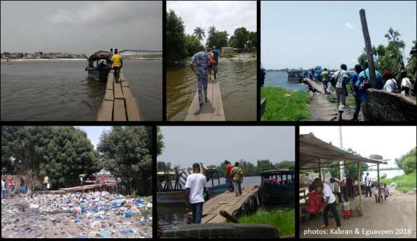
Abstract

Abidjan, the economic capital of Côte d´Ivoire, is built around the Ebrié lagoon on the Atlantic Ocean.
Boats and ferries have always been part of the urban transport system. Ferries (pinasses) are essential
to enable particularly the poor to maintain their mobility. The objective of this study is to analyse the
establishment, operation and sustainability of waterways and quays in Abidjan. The paper presents
data on 11 wooden, diesel-driven ferry lines that connect one inner city peninsula, on which the
informal and precarious settlement Adjahui is located, with other parts of the metropolis. From 2012
onwards, this paratransit ferry system has been established by private entrepreneurs who recognised
the growing demand for water transit as well as its high business potential. Data from geographic
information system (GIS) mapping, a survey among customers (n = 384), nine in-depth interviews and
counting of customers revealed that – despite operating about 54,500 rides a day – this ferry transport
is unpopular among the population. Most, however, have no transport alternative. Passengers usually
commute between their homes and workplaces on a daily basis but also keep connections to their
former quarters of residence. Though pinasses provide a demand-driven, effective and rather
sustainable transit system, further investments are needed to improve services and security, as well
as the quality of the quays and provide more environment-friendly machinery. Current profits of
private entrepreneurs would allow these investments, but findings indicate that insecurity with regard
to retention periods, as well as investments as a short-term strategy rather discourage further private
investments.

Keywords: informality, urban transport, Abidjan, paratransit, water transit, private sector, Africa

Resumé
Abidjan, la capitale économique de la Côte d’Ivoire, a été construite autour de la lagune Ebrier et
s’étend jusqu’à l’océan Atlantique. Les pinasse , depuis la periode coloniale et les bateaux des 1974
font partie du système de transport urbain. Les pinasses sont essentielles pour permettre aux citadins
pauvres de maintenir leur mobilité dans la métropole. L'objectif de cette étude sur le transport parvoie
d’eau est d'analyser la mise en place et le fonctionnement des voies navigables et des gares lagunaires.
Le document présente des données sur onze lignes de ferry en bois à moteur diesel reliant une
péninsule du centre-ville, sur laquelle se trouve des habitations informelles et précaires Adjahui, à
d'autres parties de la métropole. À partir de 2012, le système de transport adapté a été mis en place
par des entrepreneurs privés qui ont reconnu la demande croissante en matière de transit de l'eau
ainsi que son potentiel commercial élevé. Les données tirées de la cartographie GIS, d'une enquête
auprès des clients (n=384), de neuf entretiens approfondis et du comptage des clients ont révélé que
le transport par pinasses est impopulaire parmi la population, alors qu'il permet le deplacement
d’environ 54 500 usagers par jour ou il n´y pas d´autres alternatives de transport. Les passagers font
généralement des mouvements pendulaires quotidiennement entre leur domicile et leur lieu de
travail. Cependant ils conservent également des connexions avec leurs anciens quartiers de résidence.
Bien que les pinasses constituent un système de transport en commun axé sur la demande, efficace et
plutôt durable, des investissements supplémentaires permettraient d’améliorer les services,
d’améliorer la sécurité à bord et la qualité des quais. Les bénéfices actuels permettraient des
investissements dans des engins plus respectueux de l'environnement. Mais les résultats indiquent
que l’insécurité liée aux délais de rétention ainsi que des investissements à court terme découragent
plutôt les investissements privés.

Mot-clés : Informalité, transport urbain, Abidjan, transport lagunaire, paratransit, secteur privé,
Afrique

ii
1 Introduction

In Abidjan, dealing with all kinds of transport and related problems is part of the daily routine. With a
steep increase in population to 5 million inhabitants, mainly as a consequence of the civil war from
2000 to 2010, an increase of motorised transport and the geographic location on a lagoon, the existing
road infrastructure is utterly overloaded. Traffic congestion and air pollution are severe. The combined
costs for housing and transport in Abidjan are the highest in comparison to the other large cities in 20
African countries, thus categorising Abidjan as the most expensive African city in this regard (Fall and
Coulibaly, 2016: 53).

In terms of urban transport, the special geography of Abidjan, which is built around the Ebrié Lagoon
and stretches to the Atlantic coastline, is a blessing and a curse. On the one hand, the large water
bodies divide the southern parts of the city from each other, thus necessitating bridges. The four
bridges built across the lagoon turn into bottlenecks and create motorised traffic congestion each day.
Vehicles need to take long detours to reach and cross the bridges. In line with transport policies in
other countries of the Global South, the Ivorian government and donors in Côte d´Ivoire mainly focus
on the improvement of road infrastructure such as additional bridges, roads and fly-overs for
motorised vehicles (Uteng and Lucas, 2018), despite the fact that the share of privately owned cars in
the total transport fleet of Abidjan was comparatively low at about 18% a few years ago (Kumar and
Barrett, 2009 quoted in Pirie 2014:137). Private car ownership shows an increasing trend (Kassi 2007).
Public transportation consists of woroworos, gbaka (mini buses), taxis and buses. There is no bus rapid
transit (BRT). Motorbike taxis are uncommon. Non-motorised transport by bicycle or walking is
supported neither by politics nor infrastructure. An urban elevated train (Métro d´Abidjan), which
should connect the North of the city with the coast stretching over 37.5 km, has been discussed since
2011. Construction began in 2017, but the start is expected not earlier than 2022.

                                    Figure 1: Abidjan Metropolis

                                  Source: google maps 2019 (with edits)

                                                                                                       1
On the other hand, the large urban water body in Abidjan that connects many quarters along the
waterfront has a high potential for water transit (see Fig. 1). This requires the creation of waterways
and public ferry networks similar to those in Stockholm, Sydney (Tanko et al., 2018), Gothenburg,
Copenhagen, New York, Bangkok, Hamburg, London (Tanko and Burke, 2016) or Istanbul (Alpkokin,
2016). However, even with the high potential for water transport in African cities like Lagos, Monrovia
or Douala, water transit, especially when carried out with crafted wooden vessels, is very unpopular
and understood as an unsecure means of transport for people with low incomes. Thus, it seems to
suffer from a kind of stigma that prevents wealthier people from using it. Indeed, there are indications
from other cities in the Global South that ‘it is the poor who depend on ferry service more than the
privileged’ who can afford private or more expensive means of transportation (Joseph, 2012: 37, on
ferries in Kochi City Region, India).
Abidjan has a long experience with water buses and ferries. During the colonial era, the French, when
facing difficulties to penetrate the inland via land ways, used the lagoons and rivers for conquering the
hinterland and transporting goods towards the Atlantic Coast. In 1950, with the opening of the Vridi
Canal, direct access from the Atlantic into Ebrié Lagoon was created and port activities shifted towards
the lagoon. Barges and large boats were common for transporting goods across the lagoon. Also
common was the transport of passengers and smaller goods from the East to the West via crafted
wooden ferries (pinasses), which actually became easier with the opening of the inter-lagoon canals
(the Assagny and Assinie Canals). Newly constructed roads carried the increasing urban mobility. But
pinasses remained an essential means of transport, particularly between the growing settlements in
Yopougon and working places in the port, the industrial zones of Treichville and Marcory and the
offices in Plateau on the opposite side of the lagoon (Hauhouhaut 1973). In 1974, the public company
Société des Transports Abidjanais (SOTRA), which had solely focused on roads before, introduced the
first water buses (bateau bus or monbato).
Currently, there are three Ivorian transport companies (SOTRA, STL1 and Aqualine), which maintain a
total of 10 lagoonal water bus terminals (gares lagunaires). They operate six different waterways with
water buses. A large central water bus terminal is under construction at Plateau and applications for
additional concessions are currently under review at the Ivorian Transport Company (CITRANS). At the
end of the negotiation processes, concessions for a total of 30 terminals will be given out in Abidjan.
Sixteen of them will be located within the Abidjan Metropolitan Area.
Figure 2: Waterbus operated by STL
Apart from this water bus network, there exists a large network of crafted wooden ferries, which run
on diesel engines and outperform the water bus system with regard to the number of quays (gares de
pinasses) and number of ferry lines, as well as in passenger numbers. These paratransit networks were
established and are run by private entrepreneurs. They answer to the high demand for water
1
Société de Transport Lagunaire
2transport, usually by people with limited financial resources that otherwise would depend on costly
and time-consuming public road transport or walking or cycling. Taking a pinasse shortcuts their travel
and prevents costly detours over the few bridges.
The first comprehensive map of 37 wooden ferry quays in Abidjan was made by Kabran (2016). Albeit
being a typical feature of the city, they are not shown in the official city maps (CESIG 2014).2 These
pinasses quays provide mobility for about 100,000 of Abidjanais every day. The transport system of
the pinasses is established outside regulated administrative procedures for water transit. However, it
is quite flexible and may be quickly adapted to changes in mobility demands. Thus, it is an important
and dynamic transport system, which is important to be researched and understood.
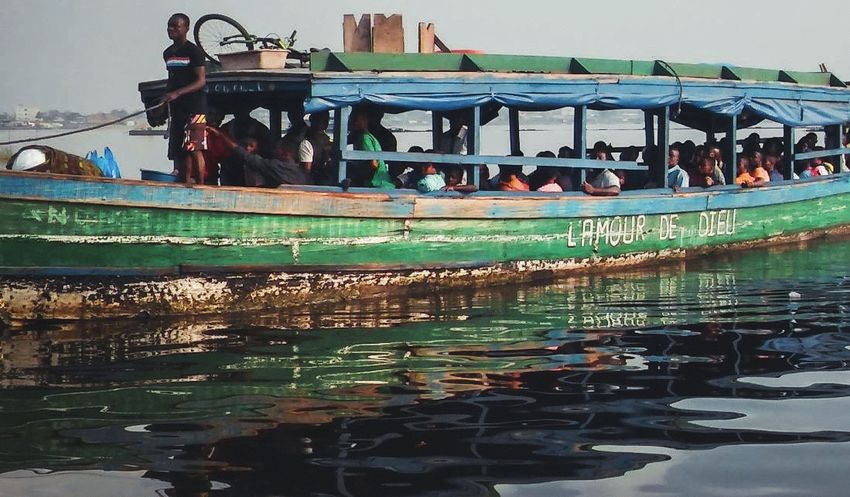
Figure 3: Crafted wooden ferries (pinasses) operated by private entrepreneurs
The objective of this study is to analyse place-making processes with regard to waterways to and from
the economically precarious and spontaneous settlement of Adjahui located in South-eastern Abidjan,
administratively part of Port Bouët Municipal District (Konan, 2016; Eguavoen et al., 2019).
Adjahui is a peninsula of about 3.67 km2 (Konan 2016:53). It has been urbanised since 2012. Before,
there was only a fishing village. The number of residents has since grown to at least 60,000 people in
mid-2018 (Eguavoen et al., 2019). The background of the establishment included forceful evictions and
a lack of affordable housing in other precarious quarters. Evictions in Abidjan (déguerpissements) had
been revived as an urban policy instrument right after the civil war (Bouquet and Kassi-Djodjo, 2014;
Eguavoen et al., 2019). Adjahui Peninsula can be reached by road from the Airport Road, but this way
is long and bumpy. There are no regular buses or taxis services to other quarters. Almost the entire
transport to and from the peninsula is via the pinasses.
After the introduction and a discussion of the concepts and methodology, the paper presents empirical
findings on the establishment and operation of wooden ferry lines around Adjahui. Afterwards, we
discuss these ferries as a paratransit system. The paper ends with an outlook on sustainable transport
options for Adjahui residents and the conclusions.
2
This map is produced by the Cabinet d´ Expertise en Systèmes Informations Géographiques, a government office.
It indicates the four water bus terminals operated by SOTRA but not the ferry lines that SOTRA operates (CESIG,
2014). In 2015, the Direction Générale des Affaires Maritimes et Portuaires (DGAMP), which is the government
body in charge of the water transport sector, did not have a comprehensive map of the wooden ferry network
including terminals and lines.
32 Concepts
The overall research project ‘Waterfront Metropolis Abidjan’ considers material infrastructure and the
production of spaces, as well as the daily practices of the residents of Adjahui together with their
resources and repertoires (Eguavoen, 2016). For an embedded empirical study on water transport, we
use additional concepts: paratransit transport systems and sustainable urban transport, briefly
introduced below.
The term ´paratransit´ is used to describe public transport systems that are established by a diversity
of private investors who operate the services outside regulatory frameworks of the state (Godard
2005). Typically, the services are based on transport with old motorised vehicles that are meant for a
comparatively small number of passengers. Minibuses are a typical and pervasive manifestation of
paratransit in Africa. There is generally not much government regulation around paratransit with
regard to schedules, prices, routes or safety. But these are not informal or illegal transport systems
because their operations and stations in public spaces are either tolerated or even formally permitted
by state authorities (Heinrichs et al., 2018). There might be routine check-ups to ensure that safety
regulations are adhered to and taxes or concessions have been duly paid by the operators. In contrast
to regular public transport, the role of the state is low compared to professional associations of private
transport operators where market access might be granted or withdrawn, and where prices of services
are regulated and conflicts may be negotiated. While Agbiboa comments on ‘how little comparative
study has been done to understand and explain the organization and politics of paratransit services’ in
African cities (2018: 4), his recent book edition on African paratransit remains also blind to water
transit.
Without getting too much into the debate about the technical details of sustainable urban transport,
it is important for our work to underline the three dimensions of sustainability. The first dimension,
which is economic sustainability, refers to the financial effectiveness of a transport system, such as
paratransit. Secondly, we briefly discuss the environmental impacts of the pinasse transport system,
and possible more sustainable alternatives. The third, the social dimension of sustainable transport,
refers to questions of accessibility, affordability and safety. In this case, it deals with questions of how
far a water paratransit system enables mobilities or enforces immobilities of poor urbanites (Uteng
and Lucas, 2018) and how mobility resources are distributed among the population in Adjahui. These
social questions have been discussed in detail by Eguavoen et al. (2019).
43 Methodology
Data on water transport were collected by Kabran and her research assistants in 2018 by documenting
field observations at gares de pinasses and during trips on the ferries, as well as by conducting semi-
structured interviews with staff and owners. These primary data were contextualised by the review of
documents, media articles and scientific work. Observations included an update of the spatial
documentation of the ferry quays connecting the municipal districts (communes) Koumassi and Port
Bouët to Adjahui Peninsula. Kabran documented the quality and equipment of the ferries with the help
of photographs. The geographic locations of the current gares de pinasses were recorded with a
Garmin GPS system. This is useful to generate a geo-referenced map, and more especially to illustrate
the spatial structuration along and across the lagoon with regard to its waterways using QGIS software
2.18.13.
Nine semi-structured interviews with individuals and groups working in ferry transport provided data
on activities, lines of connection, travel times, history of the quays, schedules, transport cost and the
number of passengers. Interviews also focused on operational costs as well as various ongoing and
envisioned projects.
Tab 1: Interview partners
Number of Number of
Respondents
interviews respondents
Ferry owners (propriètaires des embarcations) 2 2
Operational staff (pinassiers) 4 15
Head of the quay (chef de bord, chef de la gare) 3 3
Total number 9 20
The counting of passengers is central to the study. The purpose was to determine the number of
passengers transported per quay and per ferry line, as well as per hour in order to estimate the flux of
people between the various quays and their spatial–temporal variations. Although we could have
contented ourselves with counting the number of trips per pinasse, this approach would have posed
quite a challenge to the accuracy of the data. Since the estimations of passengers´ volumes are proxies,
baseline data should be as accurate as possible. Counting was implemented in small teams from
February to March 2018 using standardised counting cards. On these cards, the exact number of
passengers who had embarked and disembarked the ferries was registered. Based on the results, the
charge rate between 6 am and 8 pm was calculated.
From January to March 2018, we also observed customers at all quays and randomly interviewed 384
of them about the origin and final destination of their ongoing travel, as well as their perception of
water transport. The data derived from this survey were first entered into EPI Data software 3.1 and
later analysed with SPSS 20.0. Additional qualitative information was gathered from an ethnographic
census and observations that were conducted in Adjahui in the context of the larger research project
(for results of the census, see Eguavoen et al., 2019).
We faced some limitations with regard to data collection: Government officials were reluctant to share
data on the number of water bus operators who had applied for concessions, their mode of
recruitment and financial transactions. This had to do with the recent liberalisation of the water
transport sector, inter alia the ongoing applications for operating water buses. As long as the regular
5operators and waterways are not determined, there is not only the problem of business rivalry but
also high uncertainty among actors of the regular transport sector.
For the same reason, interview partners who operated aside the regular transport sector mistrusted
our study, as they feared that we would deliver data to government officials, which could entail an
increase in taxation or attract regular waterbus operators to apply for concessions on the waterways
where they were operating. This mistrust could partially be reduced via return visits and building social
relations with the interview partners. What data to publish and which numbers to reveal were
considered critically in order to not disturb their businesses in the future.
64 Waterways and quays
Waterways
The pinasses connecting Adjahui with other quarters in Koumassi and Port Bouët are the main mode
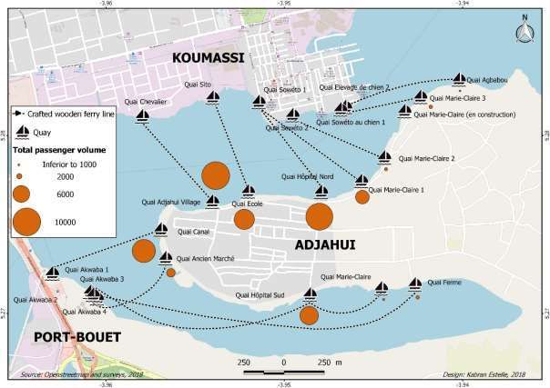
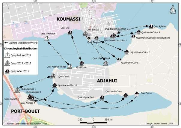
of transport in and out of Adjahui. As illustrated in Figure 4, the number of quays connecting Adjahui
has grown rapidly since 2013. During the time of the study, there were a total of 11 waterways
operated by wooden ferries and 22 quays: six at the Koumassi Waterfront, three at the Port Bouët
Waterfront and 12 in Adjahui. One quay in Adjahui was under construction. The majority of quays in
Adjahui were located at the northern waterfront and brought customers to Koumassi, where many
inhabitants work on construction sites, in the industrial zone or in artisanal workshops along the roads.
Figure 4: The evolution of quays around Adjahui Peninsula
Quays at the southern waterfront bring customers to locations near Akwaba Square. On the southern
route, the pinasses take longer routes, partly because of the need to navigate around sand mining
activities.
While the population in Adjahui was estimated at about 3,000 people in 2012, their number increased
drastically afterwards with the arrival of new settlers (Eguavoen et al., 2019). Until 2013, only one ferry
line ensured the transport towards Koumassi. This was the Chevalier (Engl. knight) –Adjahui line, a
short connection between Adjahui village and Koumassi Bia Sud. At that time, many residents in
Adjahui were working as fishermen or crab fishers and had small boats (pirogues) that allowed them
to cross the lagoon individually. The Chevalier line was created before 2013 for the primary school
teachers who taught in the Adjahui village school.
7Today six ferries under three different owners operate the Chevalier line. They are used for various
activities, for example by Adjahui housewives for shopping for food items at a market in Koumassi, or
poultry breeders to bring their livestock to Koumassi. Many employees working in Koumassi also make
use of this waterway. Finally, this waterway also offers the most direct access to the public hospital in
Koumassi.
With the steady increase in population in Adjahui, the demand for water transport also grew. Many
new settlers live around the southern waterfront of the peninsula in the newly established quarter of
Adjahui-Canal. A great many new settlers were evicted by the city government of Abidjan Metropolis
from quarters in Treichville, Marcory, Port Bouët and Koumassi. Many still work there, and use the
ferries to commute daily. Others had lived with their parents in these municipal districts before starting
a new household (Eguavoen et al., 2019).
Four new quays were established in Adjahui between 2013 and 2015, from where two new
connections started operation. The first line allowed lagoon crossing from Adjahui-Canal to Akwaba
Square (Port-Bouët). It covers a distance of 500 metres and is located where an arm of the lagoon turns
eastwards. Following the visual impression, this waterway was perceived as a canal, which is reflected
in the name of the quays, as well as in the name of the settlement. The quay in Adjahui was built
relatively close to the fishing village.
The second new line opened in 2015 at a waterway between the northern waterfront of Adjahui and
Koumassi Bia Sud where the large informal settlement of Soweto is located. This line is called the
Soweto line. On the map (Figure 4), we have indicated Soweto Quay. The gare de pinasse on the
Adjahui side, we termed Hôpital (Quay Hospital, based on the current geography of the settlement).
The location of this quay was determined by a path that connects the southern bank to the north. The
path existed before the influx of the new settlers when the land was still covered by thick bushland.
The path was the only and most convenient connection between the new settlement and the northern
bank. Through heavy pedestrian usage, the path was transformed into a road and became the most
important north–south connection in Adjahui until the present.
Since 2015, the population has further increased and the settlement spread over the entire peninsula
(Eguavoen et al., 2019). Following the pressing demand, another seven quays and nine new ferry lines
have been opened since 2015. All ferry owners expressed their interest in opening new ferry lines or
quays in the near future as the demand for transport across the lagoon is likely to further increase:
« I want to build new quays if the customary authorities accept. »3
« My project is to create new lines, because Adjahui continues to grow and the people are still
moving. So they [the ferries] have to make their move easier. »4
As the largest north–south extension of the peninsula is about 600 metres, residents have rather short
walks to either the northern or the southern quays. In general, people had to walk a distance of less
than one kilometre between their home and the gare de pinasse. In the survey, 336 passengers (88%)
resided in contiguous areas of the quays. However, there is a disparity with regard to the single quays.
The Quai École (Engl. school) had only 75% of passengers from very nearby areas or the fishing village
which is less densely populated and also displays some open public squares.
3
Ferry owner, Adjahui School – Sito line, 2018.
4
Ferry owner of Soweto line, 2018.
8Figure 5: Distances between the place of residence and the frequented quay
30 30 30 30 30 31
29 28
Frequency
25 25 26
24
3 2 2 2 2 7 8 7 4 2 1 6
Quay
< 1 km > 1km
Source: customers´ survey, 2018 (n = 384)
Quays
Quays are usually very simple at their time of establishment and get improved over time. An essential
part of every gare de pinasse is a runway to embark the ferries. Usually, these runways are made by
carpenters who use wooden planks, sometimes from recycled materials; only one runway is made
from concrete. Runways are built five to fifteen metres into the water. Some of them are quite narrow
with widths barely exceeding one metre. No runway is secured by handrails. Older terminals look
weathered and unstable. Other basic elements of a quay include a place for selling tickets and some
means to stabilise the swampy bank, which is usually done with either sand bags, plastic waste or old
tires.
9Figure 6: Gares de pinasses on Adjahui (Marie-Claire, Adjahui-Canal, Hôpital Sud)
Over time and depending on the owner, the location and the frequency of departures, quays may
undergo stepwise improvements in the form of a kiosk for ticket sales, a shaded waiting area or shops
that sell drinks and snacks.
[During my first explorative field stay in 2016], I have finally found the gare de pinasse
connecting Akwaba Square and Adjahui. Somebody had indicated the direction to me. It is
hidden behind an area covered by parking taxis and the second hand car shops all along the
road. I walk downhill to the lagoon on swampy and dirty ground. Around fifty people have
erected wooden shacks where they sell boiled eggs, other snacks and cheap items that the
traveller may wish to pursue before embarkment. As everything looks improvised, filthy and
poor, I refrain from taking photographs. There is a wooden hut where tickets are sold for 100
FCFA per trip.5
In July 2018 the visual image of the same quay is very different. On the one side, in 2017, the city
government of Abidjan demolished all the buildings and shops that were constructed between Ebrié
Lagoon and the Boulevard Valery Giscard Detaing leading over the bridge that connects Port Bouët
and Koumassi.6 After the demolition, there is a clearer view of the lagoon to the east and west of the
road. The waterfronts are covered with rubble and one can see the quay from the roadside, as well as
the waves of ferry passengers walking towards their final travel destinations. The wooden shacks have
disappeared. Only a handful of women, mostly petty traders, now work there. They bring all their
equipment – benches, umbrellas, products for sale – every morning and return with it in the evening.
The two ticket kiosks, which were just wooden shacks, are now made of metal. Some minibuses even
drive down to the quay to load passengers who have disembarked the pinasse. The quay still looks
very basic but more orderly.
5
Notes by Eguavoen, field diary, 2016.
6
This bridge has evolved into a dam due to land reclamation. This is why this bridge is often forgotten by media
and in public discourse, which claim that Abidjan has three large bridges.
10The quay leading to Soweto is the most elaborate and also the most frequented quay in Adjahui. It has
a ticket shop and a decorated wall separating the embarkment area from the waiting area, which is a
large shaded room with benches and TVs. Snacks and drinks can be bought on the market street that
leads to the quay.
Figure 7: Quay Hôpital Nord
115 Pinasses as paratransit system
All owners of the pinasses commuting between Adjahui and Koumassi/Port Bouët are men and retirees
who have invested in this transport system. They had the ferries built by artisans in Abidjan, negotiated
the ferry lines with the other owners and hired the operational staff. At the time of research, there
were eleven different waterways that were shared among eight ferry owners, who paid between
500,000 and 540,000 FCFA (ca. 760–820 euros) annually to the mayor´s office of Abidjan and the water
police in order to receive a permit for a ferry. Daily turnover may range between 150,000 and
1,000,000 FCFA (ca. 230–1,770 euros) depending on the popularity of the respective line and
passengers volume.7 Thus, despite the relatively high investment cost of about 19,680,000 FCFA (ca.
30,000 euros), investments may return within less than a year even if the ferry line is not well
frequented. The investments are hence very lucrative for the investors.
Thus, wooden ferry transport is a typical paratransit system with private entrepreneurs organising the
system. Running a pinasse requires some agreement, authorisation and taxation by the government
without being fully absorbed into official public transport regulations. While ferry owners had
participated in national meetings on water transport some years ago, they have withdrawn from this
forum because they thought that their economic interests were not safeguarded and that more
professional actors with concessions, such as STL and CITRANS, would be gaining ground and shove
individual owners of paratransit from this lucrative business.
But how did individual owners get into this ferry business in the first place? The account of one
entrepreneur illustrates how the idea of establishing a ferry line spontaneously evolved over time and
was driven by demand rather than fully projected from the beginning. Typically, ferry owners in
Adjahui had not worked in the transport sector before. Thus, they were unlikely to have all the
necessary information and experience before their personal engagement and financial investment.
« I am a retired accountant. However, I reinvested in real estate. I live in Bassam and my
driver lived at the seaside in Port Bouët. When they were evicted [in 2014], he ended up
in Adjahui close to the hospital [a first aid clinic]. In the mornings he had difficulties
getting out of there [the peninsula] to come to work. So, I had to build him a pinasse. It
cost me seven million FCFA [ca. 10,670 euros].
In the mornings, he crossed with the pinasse to reach either Koumassi or Port Bouët,
depending on his destination, and in the evening he went back to Adjahui with the pinasse.
Afterwards, the young people from the village came to see me and suggested to me to use the
pinasse to transport the population because there were long queues at the other quays,
Hôpital Nord and Adjahui Village, during rush hours. So I accepted and went to see the chefferie
of Adjahui to ask for permission.
They asked me for a drink for the spirit of the ancestors and 50,000 FCFA [ca. 76 euros], and
gave me their agreement and blessings. Then, I went to see the municipal authorities and
finally the Directorate General of Maritime and Port, DGAMP, since the lagoon banks are
areas under their jurisdiction.
It was at the end of this process that I built a shelter for my employees and users. I built a
second pinasse and started the activity. »8
7
If several waterways are operated, the earnings for a single owner are totalled, representing the higher part of
this range.
8
Ferry owner, translated interview transcription, 2018.
12This example also shows those involved in granting a use right to an aspiring ferry owner. These include
customary authorities, municipal and government offices, as well as rival private businesses. This
diversity originates from legal pluralism on the ownership and use of land and the lagoon in Abidjan
(Diarra, 2015; Coulibaly, 2017). In the customary system, the land is communal and managed by the
leaders of the autochthonous communities, the chefferies of the Ebrié. They may give out use and
usufruct rights to individual users and groups. However, according to Ivorian state law, there is no
legally defined customary land. All waterfronts are public land.9 This means waterfronts belong to the
state and are managed by the government and the municipalities on behalf of the public.
The typical approach by the ferry owners, therefore, is to make sure that they receive a permission
from all possible sides. On the one hand, this strategy to establish social contracts may reduce future
problems with any of these actors. On the other hand, none of these permits or agreements has any
legal validity. With regard to state actors and institutions, the permit may even look like a formal
printed concession. Exchange of money is termed officially as tax (even with receipts). Despite this,
the use and usufruct rights for the lagoon and the waterfronts can be withdrawn by any actor at any
time and for any reason. There is no legal way the continuation of the social contract could be enforced
by the ferry owners.
Waterways could be closed or operated by rival actors with more recent permits or agreements, or by
somebody who has more powerful support. Thus, it is advisable to be on good terms with all
stakeholders. Ferry owners have no guarantee as to how long they will be permitted to operate their
businesses. Thus, their investment is risky and based on a short-term/mid-term calculation, as well as
on their ‘social connections’ and repeated strengthening of these various social contracts.
Usually, ferry owners do not belong to the operational staff of a pinasse (pinassiers). Rather, they
oversee operations. The staff has no formal work contract, and employment conditions are orally
negotiated and agreed upon. Salaries range from 60,000 to 80,000 FCFA per month (ca. 90–120 euros),
while the Ivorian minimum wage is 60,000 FCFA a month. Thus, in line with findings about precarious
work conditions among informal transport workers in Africa (Agbiboa, 2018: 1), the incomes of the
operational staff are low, and oral work contracts do not include additional benefits.
The chef de bord (called CB) controls all the activities at the quays. He distributes ticket to the different
quays of one owner. There are four crewmen (pinassiers) per ferry: two pilots and two sailors. During
a shift, there is always one pilot who conducts the ferry and a sailor who helps. Out of the 15
interviewed pilots, 13 of them told us that their employment came about as a result of their social ties
with the ferry owner. The most important skill needed by these pilots is swimming, but only six of these
pilots can actually swim.
At the quays, tickets are sold by the collector before passengers embark the pinasses. Passengers are
controlled by staff if they hold valid tickets. There are also young people who provide security at the
quay, but their salary is not fixed and depends on the loaded goods. Thus, it is possible that their
income undercuts the minimum wage.
Every line has its own printed tickets that indicate their service periods (e.g. 05:00–22:30h, 05:00–
00:00h), contact phone numbers and professional membership of the Union des Pinassiers (see Figure
8). In order to prevent fraud with tickets, colours and designs of tickets are constantly changed. Serial
numbers, travel dates and stamps are added. Tickets are usually destroyed by the controllers on
embarkment.
9
All water bodies in the Côte d´Ivoire are public goods. A 25-metre wide waterfront is state property according
to maritime law.
13The transport fare is the same on all pinasses, irrespective of its destination: 100 FCFA per trip [0.15
euro]. Some lines take double the tariff after 22:00. The transport of pupils is free of charge.
Figure 8: Tickets
146 Connections and travel destinations
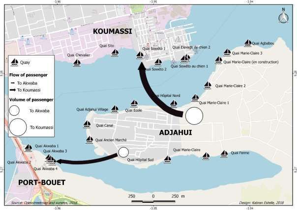
The analysis of mobility from the various stations reveals that most passengers use the waterways
connecting the peninsula to Koumassi Municipal District (Figure 9).
Figure 9: Volume of passengers per quay
The most frequented waterways connect the more central northern parts of the peninsula (Quay
Hôpital) to Quay Soweto, from where people can easily find means of transport to their workplaces.
More than 63% (34,500) of the 54,500 passengers transported daily on all waterways are commuting
along the Soweto line (Figure 10).The least frequented waterway is that connecting the quay of Élevage
des Chien and the northernmost quay in Marie-Claire. This area of Adjahui has been constructed
recently. Population densities are comparatively low. Daily, fewer than 1,000 passengers make use of
this waterway.
15Figure 10: Volume of passengers per municipal district (commune)
Overall, 97% of the surveyed passengers cross the lagoon twice a day, mainly when commuting to their
work. Many of them are secondary schoolchildren. Observations at ferry terminals in the morning rush
hour traffic supported this finding as the majority of the passengers were young men. The elderly,
women and children constitute the minority among the passengers also outside these rush hours.
Our survey showed that approximately 45% (176 out of 384 respondents) of the passengers leaving
Adjahui were headed towards Koumassi. Other notable destinations of the passengers were the
municipal districts of Marcory (20%) and Treichville (13%), which can be reached by the use of
additional means of urban transit, such as buses, minibuses or taxis. Only a few passengers travelled
to Port Bouët (total 9 out of 384). Generally, the distribution of travel destinations across the different
quays did not differ much.
16Figure 11: Travel destinations according to municipal districts (communes)
AGBABOU 13 4 2 6 5 1
MARIE-CLAIRE 3 15 5 7 3 2
MARIE-CLAIRE 2 16 4 8 3 1
MARIE-CLAIRE 1 14 3 4 5 3 3
Quay of travel start
HÔPITAL 15 1 4 6 2 4
ÉCOLE 16 4 5 3 4
ADJAHUI ANCIEN 12 1 5 8 3 4
CANAL 14 4 5 3 3
ANCIEN MARCHÉ 15 4 6 4 3
HÔPITAL AKWABA 16 5 4 3 3
MARIE-CLAIRE AKWABA 15 4 6 4 3
FERME 15 3 8 3 3
Frequency
Koumassi Port Bouët Marcory Treichville Plateau Adjame
Source: customers´ survey, 2018 (n = 384)
Adjahui residents maintain strong links with their former places of residence. When searching for new
homes, most people selected Adjahui due to its availability and much lower cost of housing in
comparison to Koumassi (Eguavoen et al., 2019). Most people, however, started searching for houses
in Adjahui because of its proximity to their former places of residence. About 82% of the respondents
told us that their former place of residence was close by.
Figure 12: Number of passengers who are in close contact with their former place of residence
27 27 27 28 27
26 26 26 25 25 25
Frequency
8 7
5 5 6 6 5 6 5 5 5
Quay/ gare de pinasse
contact to former place of residence no contact to former place of residence
Source: customers´ survey, 2018 (n = 384)
177 Crossing waterways as rite de passage
For most of the residents of Adjahui, stepping onto a pinasse and travelling over water was a new and
challenging undertaking. Despite their daily engagement in water travel, for many of them, the travel
seems more like a daily rite des passage than a routine activity. Despite the fact that Abidjanais of the
Southern municipal districts live near the lagoon and the Atlantic Ocean, most of them have never
learnt to swim. This explains their fear of water travels. During our study, we encountered residents in
other parts of Abidjan who had embarked on neither a pinasse nor a water bus. They considered water
transport an unthinkable solution to their transport challenges. Adjahui residents opined that they are
obliged to use the pinasses as there are no other alternatives.
Wooden, hand-crafted pinasses, which carry up to 100 passengers at a time, were neither trusted nor
perceived as safe mobility options. Walking on unstable runways and the stressful process of climbing
into and out of the ferry under time pressure pose challenges to many passengers, especially people
carrying loads, accompanied by small children, the elderly and the disabled. Security measures on the
ferries were grossly inadequate, as there were no life jackets and only very few life buoys on board. In
case of an accident, sinking or capsising of the pinasse, casualties would certainly be high. From this
perspective, the innate fear harboured by most of the passengers is justifiable. Fortunately, accidents
with wooden ferries are quite rare. For example, in 1974, a boat collided with a pinasse with no
recorded casualties. Also, in 2017, a pinasse heading towards Abobodoumé suffered a shipwreck, also
with no casualties.
Despite the relative safety of the ferries in comparison with road transport, water travel was perceived
as insecure and dangerous, especially by women who told us about their mixed feelings whenever
travelling on the pinasse. Time seems to stand still while sitting tight with strangers. Some passengers
are chatting, others are busy with their mobile phones. But most of them are silent and do not look at
the scenery outside the pinasse.
We are sitting in the pinasse with about 60 other passengers. A man around 40 years had refused
to sit on the timber like everybody else. He carefully watches a paper box at his feet and negotiates
with the pinassiers. Once the ferry has started the travel, he positions himself in the middle and in
front of the passengers, straightens and starts his sales performance. Today it is Chinese medicine
of bright colours in small plastic bottles that helps against any disease that the passengers might
suffer from. His speech is passionate but monotonous. He talks very loudly, but his voice is almost
swallowed by the rhythmically chugging diesel engine. Passengers look annoyed because the
salesman dominates the travel. No one can chat. But when we disembark, one or two people buy
a bottle. Over the time, we have witnessed sales performances for ginger bonbons and different
kinds of medicine, as well as several excruciating performances of self-appointed male and female
pastors. No escape possible.10
Once embarked, the passengers are trapped until reaching their destination. Crossing 500 metres of
the lagoon may take 20 or 30 minutes outside rush hours. While trips are always time consuming,
passengers also face delays in travel because of technical problems.
The engine of the ferry failed. The pinnasiers try to move the ferry away from the bank using
bamboo sticks but do not succeed. The pinasse gets stuck in the muddy waters and passengers are
stuck and trapped on their journey.11
10
Notes by Eguavoen, field diary, 2018.
11
Notes by Kabran, field diary, 2018.
18The ferry leaves from quay Soweto towards quay Hôpital. Just before arriving there, the pinasseur
informs us that we would go to quay Marie-Claire. Passengers are irritated and annoyed. They
wonder what has happened. When passing by the quay we see that the wooden runway has
collapsed. We go further east, pass a few quays before being able to debark. Passengers are not
happy as they need to walk a few hundred metres further and spend more time. Some carry heavy
luggage and small children. Some had asked while on the ferry why the pinnasiers could not
approach a closer quay. Others respond by saying that we would need to go a quay that is owned
by the same person as quay Hôpital. Three hours later when returning to Soweto the broken
runway is repaired and fully functional again.12
Many passengers stated that they were not satisfied (75%, 280 out of 384) with the ferry transport.
Mostly criticised were the wooden crafted boats and poorly lit quays, as well as long waiting times
before embarkment during rush hours. Men who work in the factories or the port told us that they
would come home by 22:00–23:00 and leave again for work around 04:00 in the morning. People
walked with torches on dark paths to the quays and had to spend many morning hours waiting in
darkness before being able to cross waterways on their way of work.13 They embark the ferries in the
dark.
There are risks related to the use of the wooden ferries in the dark. One accident was reported in
August 2018 when a young man from Koumassi Soweto fell into the water while embarking a pinasse
at night. He hit his head on the boat and his body quickly sank into the three-metre-deep lagoon.
Rescue efforts were hampered by the darkness.14 These are the kind of stories that make people fear
using the pinasses. And though incidents like this are very infrequent, they are memorised by
passengers and contribute to a feeling of insecurity.
12
Notes by Eguavoen, field diary, 2018.
13
During the time of study, many areas of Adjahui had no electricity supply since the national CIE (Companie
Ivorienne d´Electricité) had cut illegal connections in the metropolis in December 2017. As electricity supply on
the peninsula was almost entirely based on illegal connections, households lost their access to electricity and
were not reconnected as of July 2018.
14
koaci.com, 21.08.2018
198 Conclusion: How sustainable are current mobility practices
of the pinasses?
In the last few years, well-to-do retired investors responded to the urgent transport demands of
Adjahui residents and established a paratransit system in the lagoon. This is similar to motorcycle taxis
that were privately established by mainly young men in other African metropolises, such as Lagos,
Doula or Kampala as an ‘opportunistic market response’ in the face of high transport demands in
poorer urban areas (Pirie, 2014: 138).
As we have presented in the previous sections, the current water transit to and from Adjahui displays
a number of challenges for its users, mainly relatively poor people who commute to work or school.
Many of them are highly dissatisfied with the ferry transport system.
Notwithstanding its large population, there is not much motorised road traffic in Adjahui. Thus the
pinasses provide a demand-driven, safe, functional and efficient transport option. They are affordable
with low ticket prices but, of course, create additional costs for poor households that would not be
incurred if a bridge was available.
Wooden ferries are economically sustainable, too. Our data show that financial gains are high enough
to attract private entrepreneurs who invest in ferries. The system produces sufficient profit to maintain
the vessels and to pay salaries to employees who can sustain their families. Profits are actually even
large enough to reinvest the proceeds into the improvement of services, on-board security, quays and
boats. This all improves the efficiency and popularity of the transit system. But our research also
indicates that investments lack contractual security. As mentioned above, the use and usufruct rights
for the lagoon, the waterfronts and operating the waterways can be withdrawn from the ferry owners
at any time and for any reason. Most of these rights are based on social contracts but are not backed
up by legal rights or determinable concessions.
Current vessels and quays are sustainable in the sense that they were manually and locally produced
from locally available wood or recycled tarpaulin. They do not cause much environmental waste after
their functional timespan has elapsed because they are biologically degradable and can be recycled.
Waterways on Ebrié Lagoon are naturally available and do not require any energy or construction
material. Pinasses cause only very little disturbance on the ecosystem of the lagoon. Their diesel
engines, however, cause noise and emissions, as well as water pollution. More environment-friendly
machinery, such as solar engines, are technically possible but have not been established yet. And again,
investments into new technologies would require more contractual security.
Currently, Adjahui is a fully walkable settlement. Pedestrians can stroll around without being disturbed
by traffic and without squeezing themselves between parked cars as in other parts of Abidjan. Noise
and air pollution are low.
We do not intend to romanticise the difficult living and transport conditions in Adjahui. Of course,
there are also many infrastructural disadvantages. Transporting emergency patients to the nearest
hospital in Koumassi is, for example, difficult or impossible. Primary and secondary schools are out of
reach for many children. These are very serious problems. But there are different ways to solve them.
If no plans for sustainable transport are developed, it is only a question of time that motorised traffic
will evolve in Adjahui with all the problems that we see in the other quarters of Abidjan. There are
already some indicators for this less sustainable pathway:
In July 2018, we observed the first taxis coming from the airport direction to Adjahui at a cost
of 300 FCFA per travel. They were however very few.
20 According to a master plan for the eco-airport city of Abidjan, a bridge could connect Koumassi
with the airport. This car bridge would cross Adjahui, which would make it a busy thoroughfare
for residents from other quarters. The implementation of the masterplan is however on hold.
There are voices in Adjahui that call for a car bridge.
Sand mining and land reclamation in Soweto/Zoë Bruno are reducing the distance between
Koumassi and Adjahui waterfront. In July 2018, the waterway left between them amounted to
ca. 150 metres only. It seems possible that the lagoon will be closed at this end. In such a case,
no waterways would need to be crossed any longer.
As long as there is no car bridge to Adjahui, motorised road transport will be marginal and ferry
transport will be important. Studies from other waterfront cities (Joseph, 2012; Alpkokin et al., 2016;
Leung et al., 2017), however, indicate that city planners prefer building bridges over or tunnels under
water despite the fact that water transport is often a ‘better’ option in both financial and
environmental terms. Car bridges encourage individual and public motorised road traffic and come
with unwanted side effects, such as the destruction of green belts, skyrocketing land prices, accidents
and pollution (Alpkokin et al., 2016). Taking the example of Adjahui, how many minibuses or taxis
would it require to provide 54,500 trips per day? What infrastructural investments would be
necessary? What would be the environmental and health costs? A more sustainable and pro-poor
development option would be a pedestrian and cycling bridge, which could be used in addition to the
pinasses, which could continue offering more diverse connections of better quality.
Finally, paratransit of the pinasses co-evolved with the urbanisation of the peninsula. It enabled
evicted and poor families, as well as young adults, to live in a central location of Abidjan, near their
parental families and workplaces in Koumassi and Port Bouët. Their central residence is preventing
many costly, time-intense and motorised long-distance travels by woroworos and gbaka from
peripheral areas of the metropolis to the industrial zones and the port. This is why one may argue that
the pinasses around Adjahui have even contributed to more sustainable patterns of transport on the
city scale.
Seen from the social dimension of sustainability, the pinasse system has served poor populations as it
is an affordable way of water crossing. This cost, however, may accumulate when commuting. As a
result, the remoteness of the Adjahui settlement and cost of water transport enforces immobilities
especially on young females, elderly residents and children. These groups tend to remain in the
economically precarious settlement with little infrastructure most of the time in order to save
transport costs. Different than men, who commute with the pinasses to their workplaces in other parts
of the metropolis on a daily basis, these groups have less exposure to an urban lifestyle. They also face
limited education and employment opportunities because of their enforced immobilities (Eguavoen et
al., 2019).
219 Acknowledgement
The research was conducted in the project ‘Waterfront Metropolis Abidjan. Zwischen alltäglicher
Urbanität, spontaner Besiedlung, Stadtplanung und Immobilienentwicklung’ (2017–2019) funded by
the Deutsche Forschungsgemeinschaft (DFG, German Research Foundation) – EG 381/1-1.
We would like to thank participants of the 2018 ‘ZEF in the City’ Workshop, as well as Isimemen
Osemwegie and Till Stellmacher for reviewing earlier versions of this paper.
Authors
Since 2013 Estelle Gnankon Kabran (Dr.Phil. Geography) works on water transportation on the Ebrié
Lagoon in Abidjan. She is an assistant professor at the Institut de Géographie Tropical (IGT) of the
university Felix Houphouët Boigny. Since 2015 Estelle´s research is funded by the PASRES (Programme
d’Appuis Strategique à la Recherche Scientifique) at the Centre Suisse de Recherche Scientifique (CSRS)
in Côte d’Ivoire. Her main research interests are the mobility of the population, ecologic transport, and
the landscaping of urban areas. Estelle has been a team member of the ´Waterfront Metropolis
Abidjan´ project since 2017.
Irit Eguavoen (Dr Phil. Social Anthropology) works at the Center for Development Research (ZEF),
University of Bonn. Her research in Ethiopia and West Africa has covered different themes, including
the management of hand pumps, the socioeconomic impact of large dams, climate change adaptation
and governance and urban floods. Irit works as principal investigator in the DFG research project
‘Waterfront Metropolis Abidjan: Between everyday urbanity, spontaneous urbanisation, town
planning and real estate development’ since 2017.
2210 References
Agbiboa, D. E. 2018. Introduction. Transport, transgression and politics in African cities. In Agbiboa,
D.E. (Ed.). Transport, Transgression and Politics in African Cities: The Rhythm of Chaos.
London/New York: Routledge, pp. 1–16.
Alpkokin, P., J. A. Black, S. Iyinam, and A. S. Kesten. 2016. Historical analysis of economic, social and
environmental impacts of the Europe–Asia crossings in Istanbul. International Journal of
Sustainable Transportation 10(2):65–75.
Bouquet, C. and Kassi-Djodjo. 2014. ´Déguerpir´ pour reconquérir l´espace public à Abidjan. L´ Espace
Politique 22.
CESIG. 2014. Abidjan: Plan Guide. Echelle 1/25.00. 2ème édition.
Diarra, A. 2015. La lagune Ebrié d´ Abidjan à épreuve des pressions anthropopiques: Un domaine
lagunaire en Côte d´ Ivoire fortement agressé par les actions humaines. Bielefeld: Èditions
Universitaires Européennes.
Eguavoen, I. 2016. Waterfront Metropolis Abidjan. Zwischen alltäglicher Urbanität, spontaner
Besiedlung, Stadtplanung und Immobilienentwicklung. Research proposal submitted to DFG,
Bonn.
Eguavoen, I. et al. 2019. Dernier refuge ou presqu'île d'opportunités? Démographie et conditions de
vie à Adjahui, une habitation spontanée à Abidjan. ZEF Working Paper. Bonn.
Fall, M. and S. Coulibaly 2016. Diversified urbanization. The case of Côte d´Ivoire. Washington: World
Bank Group.
Godard 2005. Transport artisanal, esquisse de bilan pour la mobilité durable. INRETS, Dest, France,
http://www.codatu.org/wp-content/uploads/Transport-artisanal-esquisse-de-bilan-pour-la-
mobilit%C3%A9-durable-Xavier-GODARD.pdf (viewed 20 August 2013).
Hauhouot, A.D. 1973. Abidjan : des résidences en zones d’activité, étude des migrations quotidiennes
de travailleurs à Abidjan, Annales de l’Université d’Abidjan G(V): 147-266.
Heinrichs, D., D. Ehebrecht, and B. Lenz. 2018. Moving beyond informality? Theory and reality of
public transport in urban Africa. In Uteng, T.P. and Lucas, K. (Eds.). Urban Mobilities in the
Global South. London/New York: Routledge, pp. 134–154.
Joseph, Y. 2012. A study on inland water transportation in Kochi City Region. Centre for Public Policy
Research (CPPR) Working Paper Series. Ernakulam.
Kabran, E. G. 2016. Les entraves au développement du transport en lagune Ébrié à Abidjan. Doctoral
thesis. Université Félix Houphouët Boigny Abidjan.
Kabran, E. G., C. Y. Koffiè-Bikpo, and N. H. J. Kablan. 2016. L’utilisation du transport lagunaire
artisanal en lagune Ébrié malgré l’insécurité existante, In Short sea shipping. Myth or future
of regional transport. Procedings of the DEVPORT International Symposium , Serry, A., and
Leveque, L. (Eds.) Le transport maritime à courte distance. Mythe ou avenir du transport
régional. Le Havre: Edition EMS. pp. 2335–2347.
Kassi, I. 2007. Régulation des transports populaires et recomposition du territoire urbain d’Abidjan.
Doctoral thesis, University of Bordeaux 3 Michel de Montaigne.
Konan, P. K. 2016. Les transformations socio-spatiales d´Adjahui-Coube, une presqu´ile de la
commune de Port Bouet (Abidjan, Côte d´Ivoire). Ahoho. Revue de Geographie du LARDYMES
10(17): 53–67.
Leung, A., M. Tanko, M. Burke, and C. S. Shui. 2017. Bridges, tunnels, and ferries: connectivity,
transport, and the future of Hong Kong's outlying islands. Island Studies Journal 12:61–82.
Pirie, G. 2014. Transport pressures in urban Africa. Practices, policies, perspectives. In Parnell, S. and
Pieterse, E. (Eds.). Africa´s Urban Revolution. London/New York: Zed Books, pp. 133–147.
Tanko, M. and M. Burke. 2016. Transport innovations and their effect on cities: the emergence of
urban linear ferries worldwide. Conference paper. World Conference on Transport Research,
Shanghai.
23You can also read