WORLD METEOROLOGICAL ORGANIZATION COMMISSION FOR BASIC SYSTEMS - SEVERE WEATHER FORECASTING DEMONSTRATION PROJECT (SWFDP) GUIDEBOOK ON PLANNING ...
←
→
Page content transcription
If your browser does not render page correctly, please read the page content below
WORLD METEOROLOGICAL ORGANIZATION

         COMMISSION FOR BASIC SYSTEMS

SEVERE WEATHER FORECASTING DEMONSTRATION PROJECT (SWFDP)

      GUIDEBOOK ON PLANNING REGIONAL SUBPROJECTS

                 Revised 24 September 2008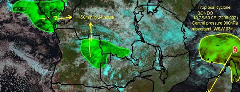
WWW/DPFS/SWFDP Guidebook, p. 2

 CBS SEVERE WEATHER FORECASTING DEMONSTRATION PROJECT (SWFDP)

               GUIDEBOOK ON PLANNING REGIONAL SUBPROJECTS

                                    TABLE OF CONTENTS

1 - Purpose of the Guidebook

2 - General Introduction

       2.1 - Objectives of the SWFDP
       2.2 - The Cascading Forecasting Process
       2.3 - Expected Benefits
       2.4 - Responsibilities of the Centres in the Framework of the Cascading Forecasting Process

3 - Preparation of Regional Subproject

       3.1 - Subproject Approval
       3.2 - Setting up of a Management Structure
       3.3 - Regional Subproject Implementation Plan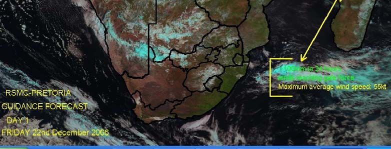
WWW/DPFS/SWFDP Guidebook, p. 3

1 - Purpose of the Guidebook

The purpose of this SWFDP Guidebook is to provide participating centres in the Project with the basic
information they need to guide in the planning and the organization of a SWFDP regional subproject. The
Guidebook includes an introductory section then explains how to prepare the subproject and the expected
milestones during its execution.

This Guidebook has been developed by the Secretariat under the guidance and review of the CBS Steering
Group for the SWFDP, also known as the Project Steering Group (PSG),

2 - General Introduction

2.1 - Objectives of the SWFDP

    2.1.1 - The scope of the Severe Weather Forecast Demonstration Project (SWFDP) is to test the
    usefulness of the products currently available from NWP centres, or products that could be made
    available from current NWP systems, with the goal to improve severe weather forecasting services in
    countries where sophisticated model outputs are not currently used. Such a demonstration project
    would use a cascading (forecasting) approach to provide greater lead-time for severe weather and
    would at the same time contribute to capacity building and improving links with disaster management or
    civil protection authorities.

    2.1.2 - According to the recommendations of the CBS-XIII (2005) the goals of the SWFDP are defined
    as follows:
       • to improve the ability of NMCs to forecast severe weather events;
       • to improve the lead time of alerting of these events;
       • to improve interaction of NMCs with DMCPA before and during events;
       • to identify gaps and areas for improvements;
       • to improve the skill of products from GDPFS centres through feedback from NMCs.

         (DMCPA – disaster management and civil protection authorities)

    2.1.3 – The CBS-Ext.(06) stressed the need to involve civil protection authorities to improve delivery of
    severe weather warning services. Regarding this aspect, collaboration with the Public Weather
    Services (PWS) and with the Disaster Risk Reduction, “DRR” programmes is encouraged.

2.2 - The Cascading Forecasting Process

    2.2.1 - In the framework of the general organization of the Global Data-Processing and Forecasting
    System (GDPFS), the SWFDP implies a co-ordinated functioning among three types of GDPFS
    centres. Conceptually, it should involve one global centre, one regional centre and a small number of
    NMHSs located within the area of responsibility of the regional centre. In practice, a project could
    involve few additional centres, if beneficial and practical to do so.

    2.2.2 - According to the conclusions of CBS-XIII, the proposed SWFDP is an excellent way to apply the
    cascading approach for forecasting severe weather in three levels, as follows:

     •   global NWP centres to provide available NWP products, including in the form of probabilities;
     •   regional centres to interpret information received from global NWP centres, run limited-area
         models to refine products, liaise with the participating NMCs;
     •   NMCs to issue alerts, advisories, severe weather warnings; to liaise and collaborate with Media,
         and disaster management and civil protection authorities; and to contribute to the evaluation of the
         project.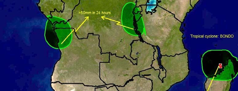
WWW/DPFS/SWFDP Guidebook, p. 4

    2.2.3 - Each centre will be required to adjust and tailor the list of products to the requirements of the
    particular regional subproject. A list of possible products to be exchanged between the centres is given
    as an example in Annex A of this Guidebook.

2.3 - Expected Benefits

    2.3.1 - The SWFDP will provide the opportunity to encourage forecasters to use and experiment with
    standard products and recommended procedures, which have already been introduced in GDPFS
    centres and which could be relevant to a number of NMHSs that have not yet used them.

    2.3.2 - The SWFDP aims to demonstrate the benefits of applying the cascading process for severe
    weather forecasting in the NMHSs, with the intention of not incurring research and development costs.
    It is viewed as way to explore how the concept could benefit several NMHSs in the same geographical
    region while facilitating a certain level of harmonization of forecasts and warnings to render them
    consistent across the region.

    2.3.3 - It is also expected that the SWFDP would help strengthen the links between the NMHS and the
    DMCPA and then to increase the efficiency and effectiveness of the public warning services in case of
    severe weather events.

    2.3.4 - In relation to the THORPEX (The Observing System Research and Predictability Experiment)
    research and development programme, it is hoped that implementation of SWFDP regional subprojects
    represents an opportunity for NMHSs and GDPFS centres to be better prepared to accommodate the
    implementation of the outcomes of this research and development programme (i.e. TIGGE/GIFS).

2.4 - Responsibilities of the Centres in the Framework of the Cascading Forecasting Process

Specific tasks are attributed to the three types of centres participating to the SWFDP in the cascading
process.

    2.4.1 - The Global Centre

     •   to provide the other centres with medium-range NWP guidance and EPS output including
         probabilistic products specially adapted to the concerned severe weather event;
     •   to suggest suitable existing satellite imagery and satellite based products that are helpful in
         assessing the current meteorological situation, and therefore also assess the quality of global
         NWP/EPS products;
     •   to evaluate the efficiency of products dedicated to medium-range severe weather forecasting
         through the feedback provided by the other centres.

    2.4.2 - The Regional Centre

     •   to redirect toward the NMHSs relevant products issued from the global centre (if necessary);
     •   to provide NMHSs with its own interpretation of the medium-range guidance, including EPS
         products;
     •   to provides the NMHSs with the short-range NWP guidance (including products adapted to severe
         weather events), as frequently as possible;
     •   to indicate existing satellite/radar imagery and satellite/radar based products that could be used
         for nowcasting purposes;
     •   to issue a severe weather daily bulletin (called the RSMC Daily Severe Weather Forecasting
         Guidance) summarizing interpretation of NWP products with respect to severe weather over the
         responsibility area of the NMHSs;
     •   to evaluate its own interpretation of EPS products as well as its NWP guidance;
WWW/DPFS/SWFDP Guidebook, p. 5

        •    to provide global centres with a feedback about the usefulness and efficiency of global products;
        •    to facilitate the flow of all forecasting guidance information to all participating Centres in the
             SWFDP through a dedicated password protected Web site and portal. Ideally this Web site would
             be maintained on a 24/7 basis and dedicated for the Regional Subproject.
        •    to coordinate real-time 24/7 communications among the participating centres in the region of the
             project (to maintain a list of 24/7 contact information; telephone, fax, e-mail)

    2.4.3 - The National Meteorological Centre of the NHMS

        •    to interpret the guidance provided by the global centre and the regional centre;
        •    to issue special bulletins and warnings as required by the end users (hydrological services,
             DMCPA services, media…) when severe weather is expected;
        •    to use available nowcasting tools (satellite imagery or satellite based products, radar products) to
             update warnings;
        •    to exchange information on warnings between participating NMHS, and between NMHS and
             RSMC centre;
        •    to provide regional and global centres with a feedback on the efficiency of the global and regional
             products;
        •    to develop a communication strategy and plan to ensure effective response when warnings are
             issued;
        •    to establish contacts with DMCPA services and other end users prior and during severe weather
             events;
        •    to obtain feedback from users after the event (opportunity of warning, lead time, degree of
             impacts);
        •    to prepare a compiled report on the severe weather events that contains all the data needed to
             perform the evaluation of both RSMC Daily Severe Weather Guidance relevant to the country,
             and actual warnings issued by the NMC;
        •    to evaluate the warnings;
        •    to develop training to facilitate improved communication with the end users.

3 - Preparation of Regional Subproject

3.1 - Subproject Approval

The establishment of a regional subproject requires a formal agreement from the participating centres. The
WMO Secretariat sends the invitation to participate:

    •       to the RA President, to seek his consent,
    •       to the Heads of the participating centres, to request their commitment.

3.2 - Setting up of a Management Structure

A regional subproject management team is to be set up with the aim of preparing the implementation of the
project and managing and controlling its execution.

    3.2.1 - Role of the Regional Subproject Management Team (RSMT)

    The responsibilities of the regional subproject management team are defined as follows:

        •    to prepare the Regional Subproject Implementation Plan (RSIP);
        •    to manage the implementation of the regional subproject;
        •    to control the execution during the field phase;
        •    to evaluate the system.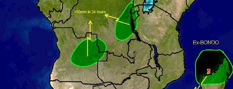
WWW/DPFS/SWFDP Guidebook, p. 6

    3.2.2 - Members of the Regional Subproject Management Team

    The Regional Subproject Management Team comprises the following members:

     •   a regional subproject Chairperson;
     •   a lead person in each of the participating centres;
     •   a Project Steering Group (PSG) contact person.

    3.2.3 - Designation of the Regional Subproject Management Team Members

    The designation of the members of the Regional Subproject Management Team is carried out through
    the following processes:

     •   The WMO Secretariat requests the RA President for designation of a subproject chairperson;
     •   The Project Steering Group (PSG) chairperson designates a contact person from PSG;
     •   The regional subproject chairperson requests each participating centres for designation of a lead
         person.

    3.2.4 - Responsibilities of the Members of the Regional Subproject Management Team

    The tasks of the members of the management team, during the preparation phase of the SWFDP are
    as follows:

    The chairperson or the Management Team:

      • to draft a detailed regional project development plan and to share between participating countries;
      • to co-ordinate training requirements that support the demonstration project and to provide
        information to WMO Secretariat;
      • to report on the project.

    The lead person for each participating centre:

      • to coordinate all aspects of project implementation and execution at their respective centres;
      • to evaluate possible data-processing developments (e.g. work required to adjust or tailor NWP
        products);
      • to arrange for forecasters in the centres to receive or have access to the agreed products;
      • to define the information to be exchanged with their DMCPA and other end users;
      • to define the information to be transmitted to the media;
      • to identify training requirements;
      • to prepare regular evaluation of the warnings during the field phase.

3.3 - Regional Subproject Implementation Plan (RSIP)

    3.3.1 - Required Regional Subproject Milestones

    The Regional Subproject Management Team is responsible for the elaboration of an implementation
    plan for the regional subproject.

    The SWFDP, in its application of a cascading forecasting process, implies close cooperation and
    coordination between the centres. The start of the field phase should be defined by the Management
    Team to encompass the period when selected severe weather events are normally expected to occur.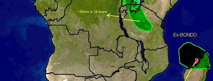
WWW/DPFS/SWFDP Guidebook, p. 7

In order to be able to make a significant evaluation of the Regional Subproject the minimum duration of
the filed phase should be one year. From a practical point of view, electronic correspondence using
reliable e-mail accounts is the principal ongoing method for project management and control.

The regional subproject implementation plan should include the following milestones:

 •   submit a project implementation plan to the Project Steering Group (PSG);
 •   convene a kick-off meeting of the Management Team to clearly and precisely define the work to
     be carried out in each participating centre;
 •   completion of preparatory training for participants.
 •   start of the field phase;
 •   conduct mid-term project review;
 •   end of the field phase;
 •   complete the final report for submission to PSG.

During the field phase it is indispensable to regularly report about the efficiency of the cascading
process and the pertinence of the warnings issued by the participating NMHSs. To this aim it is
proposed that each participating NMHS prepares a quarterly report to be sent to the RSMC and to the
chairperson of the Management Team (a proposed template of this quarterly report is given in the
Annex D of this Guidebook). It is also strongly recommended to convene a RSMT meeting at mid-term
to review the ongoing status of Regional Subproject implementation, to identify the current problems
and to decide on immediate adjustments and solutions.

3.3.2 - Technical Preparation

In the technical preparation of the SWFDP regional subproject, the Management Team needs to
finalize the list and the frequency of the products to be exchanged between the concerned GDPFS
centres and to finalize the details of the evaluation procedures. It is also essential to verify that existing
telecommunication and data-processing capability and capacity allow the transmission and display of
the SWFDP requested information. If it is necessary to implement new tasks, the additional work must
be carefully evaluated for consideration and decision by the Management Team.

     3.3.2.1 - Products to be Exchanged

     To assist participating centres in the demonstration project to define the products to be exchanged
     between the various participating centres, a sample list for consideration in the forecasting of
     severe weather is given in the Annex A of this Guidebook. An example of the content of the RSMC
     Severe Weather Daily Guidance issued from RSMC Pretoria during the SWFDP Regional
     Subproject in RA I (Southeaster Africa) is given int the Annex B of this Guidebook. The information
     to be transmitted by the NMHS toward the end-users when severe weather occurs remains under
     the responsibility and decision of the NMHS. Nevertheless, the implementation of a SWFDP
     Regional Subproject is a good opportunity to co-operate with DMCPA and other end-users to
     clearly define the content and the format of the warnings, the preferred lead-times and updates,
     the communication and the dissemination procedures.

     3.3.2.2 – Routine Evaluation Procedure

     Information for the purpose of evaluation will be required, and collected in a way that is relatively
     brief and straightforward in order to ensure that it is reliably completed on a regular basis. It is
     proposed that the information for the evaluation be collected by using an “event evaluation form” to
     ensure consistency and to allow rapid completion. This evaluation form has to be completed by
     the NMHS when a severe weather event has been observed and when a severe weather event
     has been forecast. The information that is contained in the evaluation form allows to calculate
     objective scores to assess the performances of both RSMC Severe Weather Daily Guidance and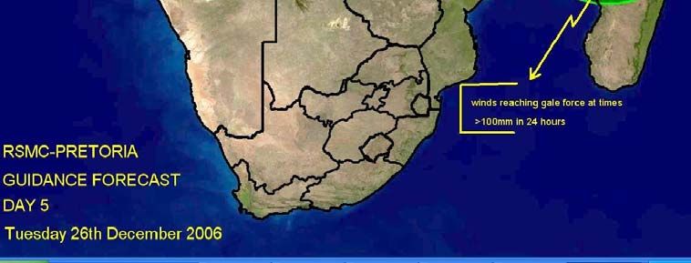
WWW/DPFS/SWFDP Guidebook, p. 8

        NMHS warning system. The way the evaluation is to be performed as well as a sample template of
        the evaluation form are given in Annex C to this Guidebook.

        3.3.2.3 - Telecommunications

        It is necessary to verify that the existing telecommunication means are capable to transmit the full
        amount of information in a timely manner as agreed between the centres participating to the
        demonstration project. This includes both the current GTS capabilities, broadband Internet
        access for displaying web pages or for file transmission using FTP. For several regions the
        possibilities to use satellite broadcast (Eumetcast, for example in Africa) should be also
        investigated. If the amount of data to be transmitted exceeds the capabilities of the existing
        telecommunication means it will be necessary to reduce the list of products to be exchanged.
        However, with regards to the duties of the NMHS, it is particularly important to ensure that the
        transmission of the weather warnings to the DMCPA services is carried out without delay.

        3.3.2.4 - Data-processing Capabilities

        The data-processing capabilities of each of the centres have to be able to produce and provide the
        forecasters with the products transmitted to it by the “upstream” centre. Depending on the kind of
        products, the exchange of new products may imply some additional workload in the regional
        centres and in the NMHSs. Storage capacity has also to be considered to allow the saving of the
        relevant products and information for project evaluation purposes.

        3.3.2.5 – Training

        Some training will probably be necessary to be sure that forecasters from regional centres and
        NMHSs are able to correctly interpret the various products exchanged during the field phase of the
        SWFDP and to prepare readable end user information especially towards DMCPAs, medias and
        other end-users. It is important to note that special training session devoted to a regional
        subproject could be planned in conjunction with existing training programmes, for example
        organized by WMO Secretariat or WMO Members.

    3.3.3 - Evaluation of the Regional Subproject Costs

The cost evaluation of the SWFDP regional subproject will be carried out on the following way:

    •   the Regional Subproject Management Team provides costing for all aspects of the subproject,
        which would mainly be incurred for holding meetings and conducting the training;
    •   the Project Steering Group (PSG) reviews the costing.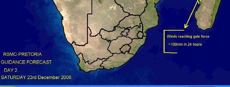
WWW/DPFS/SWFDP Guidebook, p. 9

                                               ANNEX A

        SAMPLE LIST OF PRODUCTS TO BE EXCHANGED IN A REGIONAL
                            SUBPROJECT
                   FOR FORECASTING SEVERE WEATHER

1 - Data and Products issued from the Global Centre to the other Centres.

Products which are not routinely transmitted through the GTS should be provided in graphical form (Web
pages) via Internet for rapid display and dissemination, and may also be made available by other
methods (e.g. FTP).

1.1 - Current Deterministic NWP Fields up to 5 days – at 6-h Intervals up to 2 days, 12-h intervals after 2
days).

The recommended products include:

    •   charts to depict the large-scale flow (e.g. 500 hPa , 700 hPa, 850 hPa geopotential height, 850
        hPa temperature, upper air winds, MSLP);
    •   surface weather elements (e.g. 6-hour accumulated precipitation, surface (10m) wind-speed).

In tropical regions other relevant products could also include:

    •   charts to depict the large-scale flow (e.g. surface streamlines, 850 hPa, 700 hPa, 500 hPa, 200
        hPa wind flow and relative humidity, surface streamlines);
    •   charts to assist with forecasts of tropical cyclone formation, movement and intensification (e.g.
        850 hPa, 200hPa relative vorticity and convergence, 850-400 hPa deep layer mean flow,
        850-200 hPa vertical wind shear, vertical motion);

     Frequency of products and minimum products set for daily distribution should be decided at the
     kick-off meeting.

1.2 - Probabilistic Forecast Products based on EPS

The recommended products include:

    •   probability of severe weather events such as precipitation and wind higher than given
        thresholds;
    •   “spaghetti” plots (e.g. 500 hPa geopotential height in extra-tropics, precipitation and wind higher
        than given thresholds);
    •   stamp maps (e.g. streamlines in the tropics, wind speed, accumulated precipitation);
    •   dispersion diagrams (plumes and EPSgrams) for weather elements at specific locations;
    •   representative members of a classification of weather pattern such as clustering or tubing
        (optional product depending on possibilities of Global Centre);
    •   severe weather risk index such as Extreme Forecast Index (where available).

If severe weather is associated with a Tropical Cyclone other relevant products could include:

    •   surface or 850hPa vortex track charts;
    •   tropical cyclone position fix and track forecast spread (strike probability);
    •   tropical cyclone formation probability.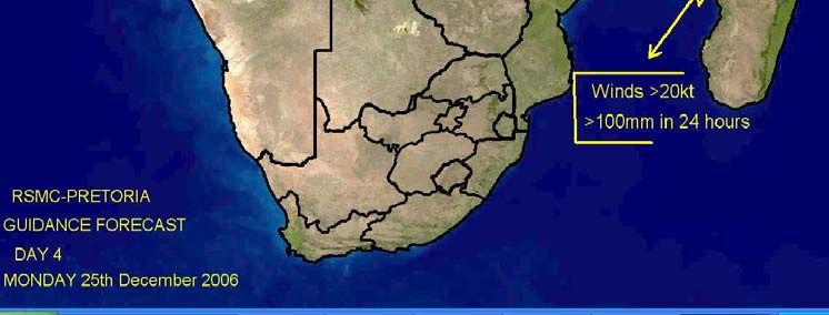
WWW/DPFS/SWFDP Guidebook, p. 10

2 - Data and Products issued from the Regional Centre to the NMHS

Products which are not routinely transmitted through the GTS should be provided in graphical form (Web
pages) via Internet for rapid display and dissemination, and may also be made available by other
methods (e.g. FTP).

2.1 To the NMHSs

    2.1.1 - Current deterministic Limited Area Model fields up to 2 days at 6-hour intervals

    Products could include, for example:

     •   charts to depict the large-scale flow (e.g. 500 hPa, 700 hPa, 850 hPa geopotential height, 850
         hPa temperature, tropopause height, upper air winds, MSLP);
     •   surface weather elements (e.g. 6-hour accumulated precipitation, surface (10m) wind-speed
         and gusts (if available), 2m temperature, 850 hPa specific humidity);
     •   maps of vertical motion, potential vorticity or height of specified PV surface;
     •   maps of convective indices such as CAPE, Lifting Index, helicity…,
     •   relevant satellite images (where NMHSs do not have satellite receiving capability);
     •   special products derived from satellite images (e.g. derived precipitation or images annotated
         with guidance notes).

   In tropical regions other relevant products could also include:

     •   charts to depict the large-scale flow (e.g. surface streamlines, 850 hPa, 700 hPa, 500 hPa,
         200 hPa wind flow and relative humidity, surface streamlines);
     •   charts to assist with forecasts of tropical cyclone formation, movement and intensification (e.g.
         850 hPa, 200hPa relative vorticity and convergence, 850-400 hPa deep layer mean flow,
         850-200 hPa vertical wind shear, vertical motion);

    Frequency of products and minimum products set for daily distribution should be decided at the
    kick-off meeting.

    2.1.2 – The RSMC Severe Weather Forecasting Daily Guidance containing the interpretation of
    products from the Global Centres and Regional Centre with a commentary, containing (as
    required):

     •   interpretation of EPS and deterministic products;
     •   severe weather predictions (risk or probability estimates).
     •   tropical cyclone formation probability (if necessary)

     A detailed content of the RSMC Severe Weather Forecasting Daily Guidance bulletin issued by
     RSMC Pretoria in the framework of the SWFDP Regional Subproject in RA I (Southeast Africa), is
     given in the Annex B of the Guidebook.

2.2 Toward the Global Centre

     • Copy of quarterly report

3 - Data and products issued from the NMHS(s)

3.1 Toward the users (hydrological services, DMPCA services and other users).

    Products should be agreed in the planning stage of the project according to the needs of the users,
WWW/DPFS/SWFDP Guidebook, p. 11
but might typically include:
• outlook bulletin for potential threats ahead;
• warning bulletin in case of severe weather, including information on probability;
• additional specific maps (if necessary);
• specific nowcasting products to update the warnings.
If severe weather is associated with a tropical cyclone:
• outlook bulletin for potential tropical cyclone formation, tropical cyclone alert or watch
containing possible tropical cyclone movement or intensification scenarios;
• tropical cyclone warnings;
• additional specific maps (if necessary, e.g. forecast track maps, strike probability).
3.2 Toward the Regional Centre
• acknowledgement of the RSMC Severe Weather Forecasting Daily Guidance;
• near-real-time information on severe events (including false alarms and non-forecast events)
via a Severe Weather Event Evaluation Form (sample template provided in Annex C of the
Guidebook).
• the quarterly report (see Annex D of the Guidebook).
It is very important to prepare carefully the quarterly report and to fill the associated quarterly
evaluation table to allow the RSMC to gather the information and to evaluate the pertinence of the
RSMC Severe Weather Forecasting Daily Guidance.WWW/DPFS/SWFDP Guidebook, p. 12
ANNEX B
RSMC SEVERE WEATHER FORECASTING DAILY GUIDANCE
TO BE ISSUED BY THE RSMC TOWARD THE NMHSs
FOR SHORT-RANGE SEVERE WEATHER FORECASTING UP TO 48 H
AND MEDIUM-RANGE SEVERE WEATHER OUTLOOK FROM 72 H TO 120 H
The RSMC Severe Weather Forecasting Daily Guidance comprises the following
parts:
• Part A: Text; depiction of the expected evolution of the weather for the
concerned range and comments about the more representative products that
are used with reference to figures included in the part B, to charts clearly
identified (model, parameter, level, forecast range) or to graphics (EPS charts
or meteograms).
• Part B: Figures; charts or graphics coming essentially from deterministic
models (global or LAM) for short range forecasts and from Ensemble
Prediction Systems (EPS) for medium range outlooks.
• Part C: The assessment of the degree of confidence of the forecast by the
forecaster.
• Part D: Tables summarizing the risk of severe weather as assessed by the
RSMC. (for short range forecasts) and the probabilities of the relevant
parameter higher than a given threshold.
• Part E: Geographical maps (one map/forecast day including the boundaries of
the countries with contours identifying the areas which are likely to be hit by the
severe weather event (for short range forecasts) or probabilities areas for its
occurrence.
The following pages of this Annex give an example of the RSMC Severe Weather
Forecasting Daily Guidance issued from RSMC Pretoria in the framework of the SWFDP
Regional Subproject in RA I (Southeast Africa) focused on heavy precipitation and
strong wind forecasting.WWW/DPFS/SWFDP Guidebook, p. 13
RSMC-PRETORIA
SWFDP GUIDANCE PRODUCTS
SHORT-RANGE (DAY 1 AND DAY 2)
Issue Date: Friday 22nd December 2006
Valid for: 22nd, 23rd December 2006
1. SYNOPSIS OF EXPECTED WEATHER PATTERNS
Day 1: 22nd December 2006
RSMC / TROPICAL CYCLONE CENTRE / LA REUNION
Tropical Cyclone warning (South-West Indian Ocean)
Position 2006/12/22 at 0600 UTC : within 20 NM radius of point 10.2S / 50.0E.Cntral
pressure: 980 HPA
Max average win d speed (10 MN) : 55 KT
The system is rapidly weakening in a strongly southeasterly sheared environment.
It has slow down and is expected to curve.
Day 2: 23rd December 2006
TS BONDO near 11S 47E by midday tomorrow.
2. SATELLITE IMAGES AND SYNOPTIC DATA.
Tropical cyclone visible north of Madagascar.
2. DISCUSSION OF GUIDANCE PRODUCTS FROM GLOBAL AND REGIONAL
CENTRES
Regional Models (UM SA 12, UM African LAM)
Forecaster: Evert Scholtz.WWW/DPFS/SWFDP Guidebook, p. 14 GRAPHICAL ADDITIONS F ig 1. Quicksat surface winds DAY 1 Fig 2. Satellite image and 150-300 Hpa divergence DAY 1
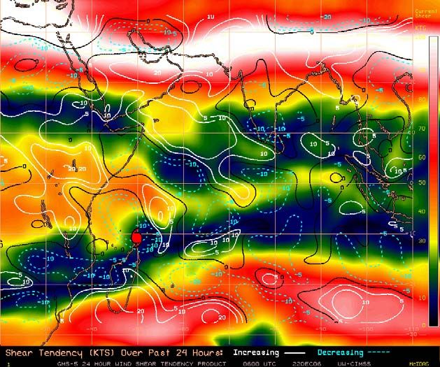
WWW/DPFS/SWFDP Guidebook, p. 15

Fig 3. Shear tendency over past 24 h on DAY 1
WWW/DPFS/SWFDP Guidebook, p. 16

                         RSMC-PRETORIA
                    SWFDP GUIDANCE PRODUCTS
                          RISK TABLES
                        SHORT-RANGE (DAY 1 AND DAY 2)

Issue Date: 22nd December 2006
In order to provide more information about the geographical location of the severe
event the following convention is adopted when filling in the cells: X for the whole
country, N for the northern part, S for the southern part, W for the western part and E
for the eastern part.

DAY 1: Friday 22nd ecember 2006
                            HEAVY PRECIPITATION                  STRONG WINDS
RISK                  No risk   Low    Medium     High     No    Low    Medium    High
                                risk    risk      risk    risk   risk    risk     risk
Botswana               X                                   X
Madagascar                                         N                               NE
Mozambique              X                                 X
Tanzania                X                                 X
Zimbabwe                X                                 X

DAY 2: Saturday 23rd December 2006
                            HEAVY PRECIPITATION                  STRONG WINDS
RISK                  No risk   Low    Medium     High     No    Low    Medium    High
                                risk    risk      risk    risk   risk    risk     risk
Botswana               X                                   X
Madagascar                                         N                                N
Mozambique              X                                 X
Tanzania                X                                 X
Zimbabwe                X                                 X
WWW/DPFS/SWFDP Guidebook, p. 17
SEVERE WEATHER RISK MAP
FOR SHORT RANGE (DAY 1 AND DAY 2)WWW/DPFS/SWFDP Guidebook, p. 18
RSMC-PRETORIA
SWFDP GUIDANCE PRODUCTS
MEDIUM-RANGE (DAY 3, DAY 4 AND DAY 5)
Issue Date: 22nd December 2006
Valid for: 24th , 25th & 26th December 2006
2. SYNOPSIS OF EXPECTED WEATHER PATTERNS
DAY 3 24th December 2006
According to ECMWF, GFS & NOAA NWS the tropical low will be situated on the
north-west coast of Madagascar on day 3. with central pressure close to 1000hPa.
Degree of confidence (moderate to high)
DAY 4 25th December 2006
Tropical low (ex-BONDO) still on the north-west coast of Madagascar.
Degree of confidence (moderate to low – mainly uncertainty relating to speed /
movement / positioning of tropical system)
DAY 5 26th December 2006
Tropical low (ex-BONDO) moving into to the central part of the Mozambique channel
and intensifies with central pressure below 1000hPa. ( by day 6 ECMWF moves it
towards Mozambique coast and making landfall near Xai-Xai on the south coast of
Mozambique on day 7, 28th December.
Degree of confidence (low – mainly uncertainty relating to speed / movement /
positioning of tropical system – with a 5 day lead-time there is extreme uncertainty in
this regard)
3. DISCUSSION OF GUIDANCE PRODUCTS FROM GLOBAL AND REGIONAL
CENTRES
(Comments about the products that are used with reference to figures or charts
included under bullet 3)
Forecaster: Evert Scholtz.WWW/DPFS/SWFDP Guidebook, p. 19 GRAPHICAL ADDITIONS Fig 1. 1000 Hpa Relative humidity and streamlines DAY 3. FIG 2. 1000 Hpa Relative humidity and streamlines DAY 4.
WWW/DPFS/SWFDP Guidebook, p. 20

Fig3. 1000 Hpa Relative humidity and streamlines DAY 5.
WWW/DPFS/SWFDP Guidebook, p. 21

                         RSMC-PRETORIA
                    SWFDP GUIDANCE PRODUCTS
                       PROBABILITY TABLES
                   MEDIUM-RANGE (DAY 3, DAY 4 AND DAY 5)

Issue Date: 22nd January 2007

In order to provide more information about the geographical location of the severe
event the following convention is adopted when filling in the cells: X for the whole
country, N for the northern part, S for the southern part, W for the western part and E
for the eastern part.

DAY 3: 24th January 2007
                             HEAVY PRECIPITATION                     STRONG WINDS
                         (exceeding threshold 50 mm/6 hrs)      (exceeding threshold 20 kts)
Probability             80%     80%
Botswana               X                                      X
Madagascar                                                    X
                                E coast
Mozambique             X                                      X
Tanzania               X                                      X
Zimbabwe               X                                      X

DAY 4: 25th January 2007
                             HEAVY PRECIPITATION                     STRONG WINDS
                         (exceeding threshold 50 mm/6 hrs)      (exceeding threshold 20 kts)
Probability             80%     80%
Botswana               X                                      X
Madagascar                                E coast             X
Mozambique                      Cent                          X
                                coast
Tanzania               X                                      X
Zimbabwe               X                                      X

DAY 5: 26th January 2007
                             HEAVY PRECIPITATION                     STRONG WINDS
                         (exceeding threshold 50 mm/6 hrs)      (exceeding threshold 20 kts)
Probability             80%     80%
Botswana               X                                      X
Madagascar                                E coast             X
Mozambique             X                                      X
Tanzania               X                                      X
Zimbabwe               X                                      X
WWW/DPFS/SWFDP Guidebook, p. 22 SEVERE WEATHER PROBABILITY MAP FOR MEDIUM RANGE (DAY 3, DAY 4 AND DAY 5)
WWW/DPFS/SWFDP Guidebook, p. 23
WWW/DPFS/SWFDP Guidebook, p. 24

                                               ANNEX C

         EXAMPLE OF A SEVERE WEATHER EVENT EVALUATION FORM

The proposed evaluation form should allow to evaluate the performance of the RSMC Severe Weather
Forecasting Guidance and as well as the efficiency of the NMHS warning system.

It must be completed by the NMHS in both of the following cases:
    • a severe weather event has been observed; and
    • a severe weather event has been forecast.

The evaluation form should document the characteristics of the severe weather event (whether
observed or forecast) and allow to evaluate the efficiency of the forecasts given by the RSMC Severe
Weather Forecasting Daily Guidance as well as the performance of the warnings issued by the NMHS.
Therefore it should include the three following sections.

Section A – Identification of the severe weather event:
   • NMHS concerned;
   • number of the event;
   • type of event;
   • region affected.

Section B – Information about the observed weather event:
   • start and end times of the severe weather event;
   • maximum observed value of the characteristic parameter;
   • assessment about the efficiency of the warning given the DMCPA;
   • information from the end-users (number of interventions, casualties, damages, usefulness of
       the warning ).

Section C – Information about the forecast and warning issued from the NMHS:
   • lead-time of the warning;
   • start and end time of the severe weather event according to the forecaster’s assessment;
   • level of risk as indicated in the RSMC Severe Weather Forecasting Daily Guidance;
   • probabilities of medium-range in the RSMC Severe Weather ForecastingDaily Guidance;
   • usefulness of the various products (RSMC Guidance, various models);
   • comments including information on usefulness and applicability of used tools.

How to use this evaluation form to evaluate the performance of warnings ?

The common way to evaluate the performance of a warning system is based on the 2 x 2 contingency
table matrix including the number of justified warnings (“hits”) “a”, the number of missed severe events
“b” and the number of false alarms “c”. The POD index (Probability of Detection) is defined as the ratio of
the number of hits by the total number of severe events, i.e., a/(a+b) ; the FAR (False Alarm Ratio) is
defined as the ratio of the number of false alarms by the number warnings issued, i.e., c/(a+c).The
information contained in the proposed evaluation form enables to computes the performance indicators
of the warning issued by the NMHS as long as the assessment of the DMCPA (in section C) is correctly
taken into consideration.

A template of an evaluation form is provided in the following pages. The evaluation form is to be filled by
the NMHSs (preferably by a forecaster or manager of the forecasting unit) participating to the SWFDP
regional subproject. This template can be modified with respect to the products selected for preparing
the severe weather forecasts and warnings.

It is important that the design of the evaluation form be adapted to allow the data and information to be
easily gathered and transformed into a tabular form. Avoid unnecessary and repetitive typing, and as
much as possible to encourage and allow reliable creation and maintenance of the dataset that is
needed to analyze and evaluate the performance indicators.
WWW/DPFS/SWFDP Guidebook, p. 25
WWW/DPFS/SWFDP Guidebook, p. 26

                               SEVERE WEATHER EVALUATION FORM
                                           (Page 1)

INSTRUCTIONS:            :
1. This form must be filled in whenever:             (1) Severe weather is observed (Sections A and B)
                                                     (2) A warning has been issued to DM/CPA (Sections A and C)

2. Email the completed document to RSMC Pretoria, WMO and other agreed recipients
   To standardize please put the title “SWFDP Evaluation Form” in the title list of the email

A. IDENTIFICATION OF THE SEVERE EVENT

                 NMHS:                                                Alphabetic

      Region affected:                                                Alphabetic

        Event Number:                                                 Numeric

Type of event:                                                        Numeric      (put the right number in the cell)

1: Heavy Precipitation   (indicate the most significant phenomenon,
2: Strong wind           either heavy precipitation or strong wind)

Severe convection                                                     Numeric      (put 1 if extreme phenomena are
                                                                                   the consequence of severe
                                                                                   convection or 0 otherwise)

B. SEVERE WEATHER OBSERVED (to be completed even if no severe weather has been forecast)

                                                                      JJ     MM     DD            HH     MM
                               Start of the event:                                          at                  UTC
                               End of the event:                                            at                  UTC

 Max. observed value:                                                 Unit
                               Numeric               Alphabetic
(According to the event: accumulated precipitation, gusts, other significant parameter)

Information from the end-users
short text explaining the consequences and possibly some figures
(number of interventions, casualties, damages, usefulness of the warning )
WWW/DPFS/SWFDP Guidebook, p. 27
SEVERE WEATHER EVALUATION FORM
(Page 2)
C. SEVERE WEATHER FORECAST (to be completed even if severe weather did not occur)
JJ MM DD HH MM
Time of the warning toward DMCPA at UTC
Start of the event; forecaster assessment at UTC
End of the event; forecaster assessment at UTC
Usefulness of the warning (feedback from the DMCPA)
check in the chosen cell Lack of warning
False alarm
warning
Late warning
Useful warning
Level of risk as appreciated by RSMC (put 1 in the chosen cell)
No Low Med. High
Level of risk 1 day before:
Level of risk 2 days before:
Probabilities of medium range outlooks as appreciated by RSMC
Probability 3 days before: %
Probability 4 days before: %
Probability 5 days before: %
Mark for usefulness of products (put 1 in the chosen cell)
Guidance
RSMC
KEY NWP EPS
A = Very useful (basis of the warning) ECMWF
B = Useful (aided warning confidence) NCEP
C = Neutral (not useful) Met Office
D = Negative (misleading) RSMC LAM
X = Not used
Comments including information on usefulness and applicability of used toolsWWW/DPFS/SWFDP Guidebook, p. 28
WWW/DPFS/SWFDP Guidebook, p. 29

                                         ANNEX D

            EXAMPLE OF THE INFORMATION TO BE INCLUDED IN THE
               QUATERLY REPORT OF THE SEVERE WEATHER
                         REGIONAL SUBPROJECT

                                  NMC : - - - - - - - -
                            PERIOD: (Start date to end date)

1.      HIGHLIGHTS OVER THE PERIOD

2.      OVERVIEW OF PRODUCTS

        a. Usefulness of RSMC-Devere Weather Daily Guidance
        b. Usefulness of SWFDP NWP/EPS Products received from each global centre and
           RSMC Limited Area Model (if available)

3.      PROJECT EVALUATION AGAINST SWFDP GOALS

SWFDP GOAL                                     PROGRESS AGAINST GOALS

To improve the ability of NMCs to forecast
severe weather events

To improve the lead time of alerting these
events

To improve the interaction of NMCs with
Disaster Management and Civil Protection
authorities before, during and after severe
weather events

To identify gaps and areas for improvements

To improve the skill of products from Global
Centres through feedback from NMCs

4.      EVALUATION OF WEATHER WARNINGS

        A) Feedback from the public
        B) Feedback from the DMCPA to include comments of the timeliness and usefulness of
           the warnings
        C) Feedback from the media
        D) Warning verification by the NMCs

5.      SUMMARY (general comments, challenges, etc)

6.      CASE STUDY (PowerPoint presentation to include guidance products (RSMC and NWP),
        satellite imagery, warnings issued, impact evidence etc)
WWW/DPFS/SWFDP Guidebook, p. 30
ANNEX E - Quarterly Evaluation Table (to be fulfilled based on the Severe Weather Event Evaluation Form)
An row has to be filled in this table whenever a severe weather event is observed or a warning is issued toward DMCPA.
SWFDP
Starting Evaluation Region Highest Which NWP/EPS forecast Local Impact of Impact of the
date Form Type of event affected observed RSMC Guidance product(s) used by NMC warnings the event warning
of the Event value issued?
event Number
Indicate if extreme Indicate the specify Amount Usefulness Indicate the Usefulness Yes Damages, According to
phenomena are region of the units, predicted from 1 to 4 model(s) from 1 to 4 or Casualties the DMCPA
dd/mm/yy the consequence country hit by according (same unit used No assessment
of severe the severe to the as in the 1- Misleading 1- Misleading
convection weather phenomenon preceding 2 - Not useful 2 - Not useful
column) 3 - Useful 3 - Useful
4 - Very 4 - Very
useful usefulYou can also read