January 2015 Goldfields Esperance Development Commission Esperance Cruise Ship Infrastructure Review - www.coastsandports.com.au - Shire of Esperance
←
→
Page content transcription
If your browser does not render page correctly, please read the page content below
R601 Rev 0

January 2015

Goldfields Esperance Development
Commission

Esperance
Cruise Ship Infrastructure Review

www.coastsandports.com.au

m p rogers & associates pl          Esperance Cruise Ship Infrastructure Review
                                           K1205, Report R601 Rev 0, Page (i)
m p rogers & associates pl
creating better coasts and ports

Suite 1, 128 Main Street, Osborne Park, WA 6017
p: +618 9254 6600
e: admin@coastsandports.com.au
w: www.coastsandports.com.au

K1205, Report R601 Rev 0
Record of Document Revisions
  Rev            Purpose of Document           Prepared     Reviewed        Approved         Date

   A        Draft for MRA and GEDC review      D Olsson      B Smith        D Olsson       24/12/14

   0        Incorporating GEDC Comments        D Olsson     M Rogers        D Olsson        27/1/15

Form 035 18/06/2013

Limitations of this Document
This document has been prepared for use by the Client in accordance with the agreement
between the Client and M P Rogers & Associates Pty Ltd. This agreement includes constraints on
the scope, budget and time available for the services. The consulting services and this document
have been completed with the degree of skill, care and diligence normally exercised by members
of the engineering profession performing services of a similar nature. No other warranty,
expressed or implied, is made as to the accuracy of the data and professional advice included.
This document has not been prepared for use by parties other than the Client and its consulting
advisers. It may not contain sufficient information for the purposes of other parties or for other
uses.

M P Rogers & Associates takes no responsibility for the completeness or form of any subsequent
copies of this document. Copying this document without the permission of the Client or
M P Rogers & Associates Pty Ltd is not permitted.

m p rogers & associates pl                                Goldfields Esperance Development Commission
                                                            Esperance Cruise Ship Infrastructure Review
                                                                       K1205, Report R601 Rev 0, Page i
Table of Contents
1.    Introduction                                                                          5
1.1    Stakeholders                                                                         6
2.    Background                                                                            7
2.1    Location                                                                             7
2.2    Existing Infrastructure                                                              8
2.3    Tidal Range                                                                        13
2.4    Typical Wind and Wave Conditions                                                   13
2.5    Volendam Visit 11/11/14                                                            15
2.6    Existing Cruise Ship Facilities                                                    17
3.    Comparison with Other Ports                                                         23
3.1    Albany                                                                             24
3.2    Augusta                                                                            26
3.3    Geraldton                                                                          27
3.4    Estimated Number of Cruise Ships Visits                                            27
4.    Summary of Esperance Existing Situation                                             29
5.    Potential Infrastructure Locations                                                  35
5.1    Bandy Creek                                                                        35
5.2    James Street                                                                       35
5.3    Taylor Street                                                                      40
5.4    Southern Ports Authority                                                           43
5.5    Tanker Jetty                                                                       47
5.6    Cruise Ship Berthing at James Street                                               52
6.    Recommendations                                                                     55
7.    References                                                                          57
8.    Appendices                                                                          58
Appendix A      Concept Option Sketches                                                   59

m p rogers & associates pl                       Goldfields Esperance Development Commission
                                                   Esperance Cruise Ship Infrastructure Review
                                                             K1205, Report R601 Rev 0, Page ii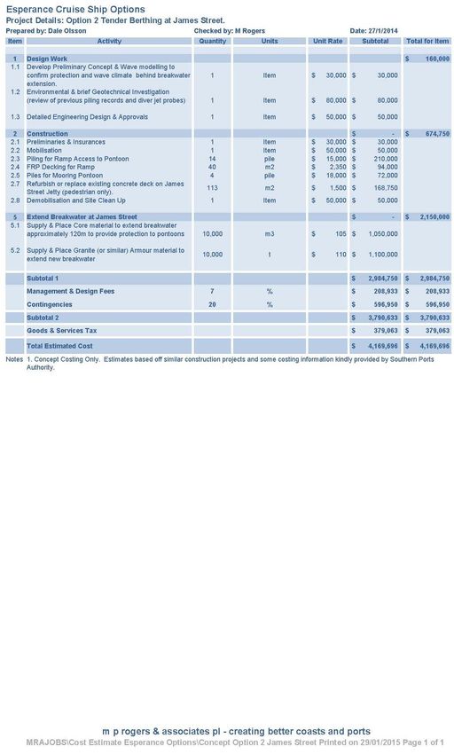
Table of Figures
Figure 1.1   Cruise Ship Anchored off Esperance Port.                                          5
Figure 1.1   Welcoming Passengers Ashore.                                                      5
Figure 2.1   Esperance Location                                                                7
Figure 2.2   Esperance Esplanade and Port                                                      8
Figure 2.3   Esperance Yacht Club Pens                                                         9
Figure 2.4   Esperance Yacht Club Wharf and Crane                                              9
Figure 2.5   Taylor Street Jetty                                                             10
Figure 2.6   Cruise Ship Tender and Pontoon in Place at Yacht Club Wharf                     10
Figure 2.7   James Street Swimming Jetty                                                     11
Figure 2.8   Esperance Historical Tanker Jetty                                               12
Figure 2.9   Bandy Creek Commercial Boat Harbour Pens                                        12
Figure 2.10 Bandy Creek Commercial Boat Harbour Entrance                                     13
Figure 2.11 Esperance Ports Wave Recording Location Beacon 2                                 14
Figure 2.12 Esperance Ports Wave Recording Location                                          15
Figure 2.13 Total Significant Wave Height and Total Peak Period at Beacon 2 on
            11/11/14                                                         16
Figure 2.14 Esperance Ports Berth 1 & 2                                                      18
Figure 2.15 Esperance Port Layout                                                            18
Figure 2.16 Cruise Ship Anchored in Esperance Bay                                            19
Figure 2.17 Approximate Cruise Ship Anchoring Location                                       20
Figure 2.18 Tender Vessel, Pontoon, Gangway and Mooring Arrangement.                         20
Figure 3.1   Cruise Ship Berthing at Albany Port                                             25
Figure 4.1   Esperance Port Existing Pontoons and Gangway                                    31
Figure 4.2   Tender Vessel and Pontoons in Place                                             32
Figure 4.3   Cruise Ship Passengers Current Walk into Town Centre                            33
Figure 5.1   James Street Groyne and Swimming Jetty                                          36
Figure 5.2   James Street Floating Tender Pontoon Concept                                    37
Figure 5.3   Example Fixed Lower Level Vessel Landing                                        38
Figure 5.4   Concept Option 1 - Taylor Street Pontoon and Proposed Pedestrian
             Link                                                            40
m p rogers & associates pl                         Goldfields Esperance Development Commission
                                                     Esperance Cruise Ship Infrastructure Review
                                                               K1205, Report R601 Rev 0, Page iii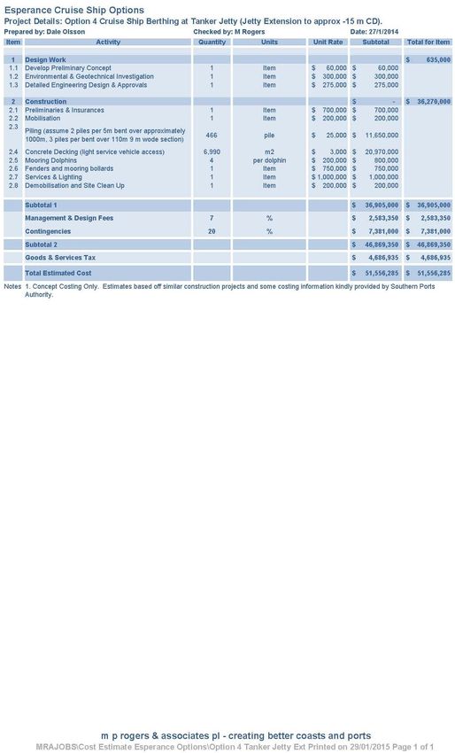
Figure 5.5   Concept Option 3 - Southern Ports Authority Concept for Multi User
             Berth and Relocation of the Yacht Club                            44
Figure 5.6   Concept Option 4 - Tanker Jetty Extension Option                            48
Figure 5.7   Concept Option 5 - Tanker Jetty Dredging Option                             48
Figure 5.8   Concept Option 6 – Cruise Ship Berthing Facility at James Street 52

Table of Tables
Table 2.1    Advantages and Disadvantages of Berthing Options                            22
Table 3.1    Tourism WA Rating of Cruise Ship Ports (TWA 2012)                           24
Table 3.2    Estimated Number of Cruise Ship Visits to WA Ports                          28
Table 4.1    Infrastructure Summary                                                      34

m p rogers & associates pl                      Goldfields Esperance Development Commission
                                                  Esperance Cruise Ship Infrastructure Review
                                                            K1205, Report R601 Rev 0, Page iv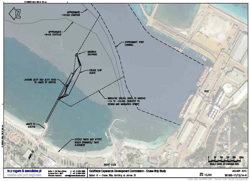
1. Introduction
Cruise Ship tours are increasingly becoming a bigger sector of the Australian Tourism market.
There is the potential for the Cruise Ship tourism industry to add to the tourism markets of
Western Australia’s regional towns. The Cruise Ships provide a short term impact from their
immediate visit and there is also a longer term benefit in showcasing the region to a greater
number of travellers who may decide to re-visit the region at a later date.

The Goldfields Esperance Development Commission (GEDC) in partnership with Tourism
Esperance, Southern Ports Authority (Esperance Port), Shire of Esperance, Esperance Chamber
of Commerce and Industry and Tourism WA wished to investigate the potential options for
enhancing the Cruise Ship tourism sector within the Town.

Figure 1.1     Cruise Ship Anchored off Esperance Port.

Figure 1.1     Welcoming Passengers Ashore.

Passenger’s opinions of the region derived from their brief visit on the Cruise Ship may impact the
viability of future Cruise Ship visits to the town as well as the long term tourism potential.
Providing the necessary infrastructure to make the transfer of passengers from the Ship to the
Shore and vice versa safe and efficient adds to the passenger’s enjoyment of the brief stopover.
Providing an economical and safe transfer of passengers in all weather conditions as well as
providing a strong tourism product aids in being a favourable Port of call with Cruise Ship
companies.

GEDC commissioned specialist coastal and port engineers M P Rogers and Associates Pty Ltd
(MRA) to undertake a review of the current infrastructure available within Esperance for the

m p rogers & associates pl                                 Goldfields Esperance Development Commission
                                                             Esperance Cruise Ship Infrastructure Review
                                                                       K1205, Report R601 Rev 0, Page 5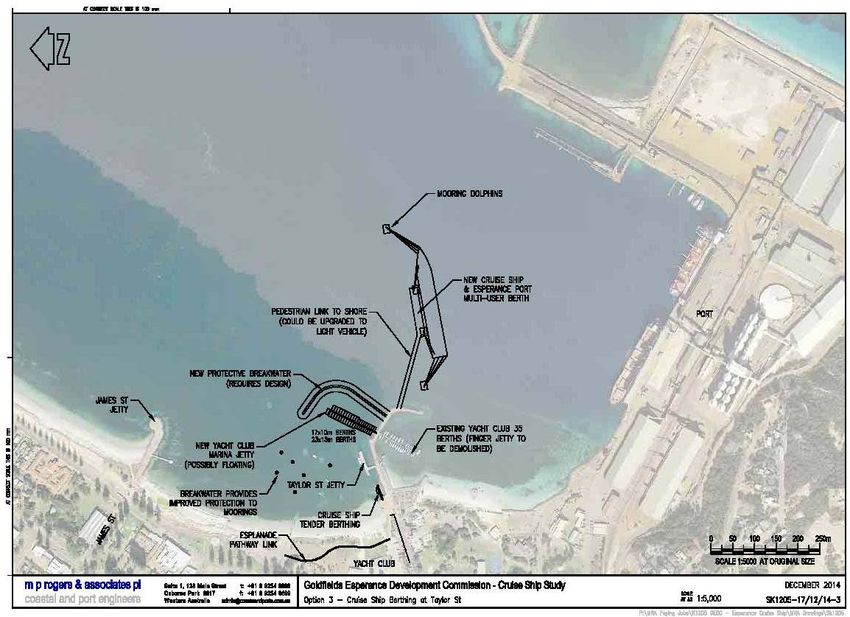
berthing of Cruise Ships and also to provide some concepts that may optimise Cruise Ship visits
to the region.
1.1 Stakeholders
Senior Engineer Dale Olsson from MRA undertook a site inspection of the existing facilities within
the region on the 27 to 28 November 2014. Consultation with the following stakeholders was
conducted in conjunction with GEDC:
Southern Ports Authority (Esperance Ports Sea and Land).
Shire of Esperance.
Tourism Esperance.
Esperance Cruise Ship Committee.
Esperance Bay Yacht Club (Yacht Club).
Esperance Chamber of Commerce and Industry.
m p rogers & associates pl Goldfields Esperance Development Commission
Esperance Cruise Ship Infrastructure Review
K1205, Report R601 Rev 0, Page 6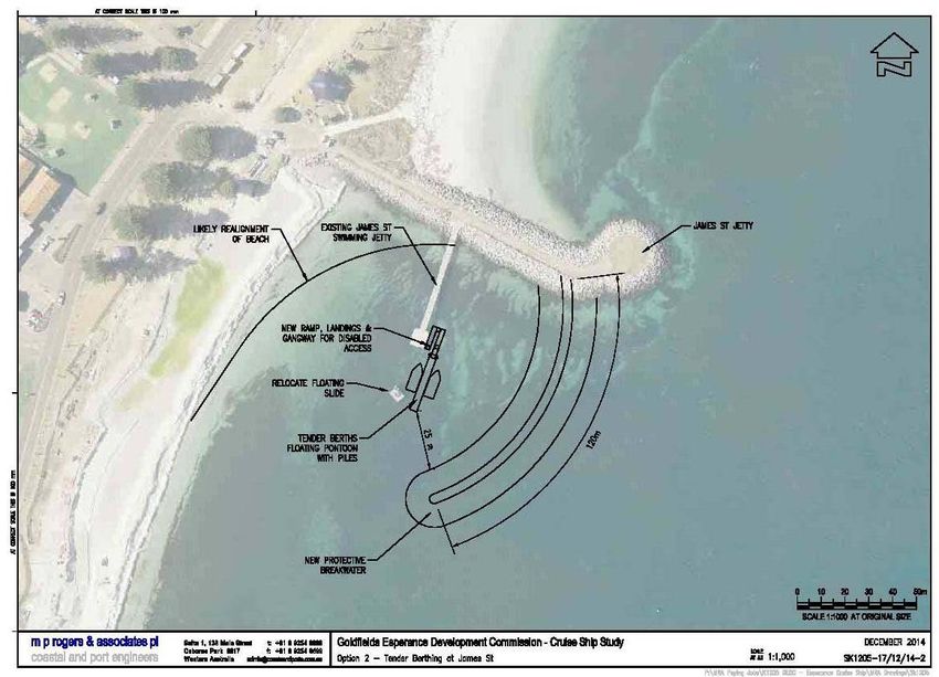
2. Background
2.1 Location
Esperance is located on the south coast of Western Australia, approximately 700 km south east of
Perth. It is located approximately 1,500 km west of Adelaide and the next closest major Port is
Albany which sits a further 400 kilometres west. Figure 2.1 shows the general setting of
Esperance Bay.

       PERTH

                        ESPERANCE

               ALBANY
               Y

                                                                       ADELAIDE
                                                                       1,500 km

                          ALBANY
                          400 km

Figure 2.1       Esperance Location

m p rogers & associates pl                               Goldfields Esperance Development Commission
                                                           Esperance Cruise Ship Infrastructure Review
                                                                     K1205, Report R601 Rev 0, Page 7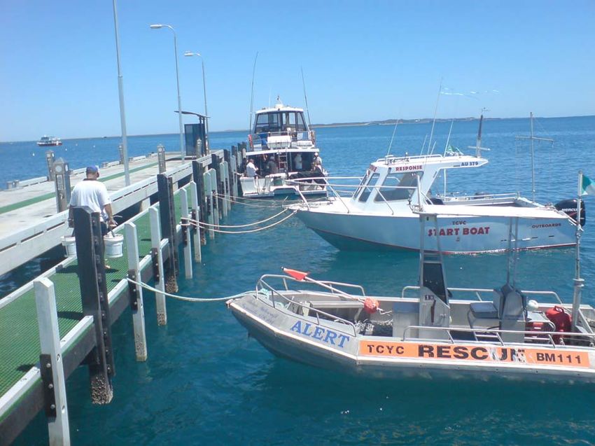
N
                                      Esperance Bay

                Tanker Jetty

                                                                            Esperance Port
                               Esperance Esplanade

                                            James Street   Yacht Club and
                                             Jetty          Taylor Street
                                                           Jetty

Figure 2.2     Esperance Esplanade and Port

2.2 Existing Infrastructure
The Port forms the southern end of Esperance Bay as seen in Figure 2.2. It is in close proximity
to the Town and there are several jetty structures along the front of the Town Esplanade.

2.2.1 Esperance Bay Yacht Club
The Yacht club sits between the Port and the main section of the Esplanade. The Yacht club has
a small breakwater to form a marina with fixed jetty pens for approximately 35 recreational
vessels as seen in Figure 2.3. The marina structure is in a degraded condition and the yacht club
is looking at replacement options in the coming years. The Yacht club also has a small land back
wharf area to allow for the small vessels to be lifted into and out of the water (Figure 2.4). This
wharf and crane area is also where the Cruise Ship temporary pontoons are located.

m p rogers & associates pl                                  Goldfields Esperance Development Commission
                                                              Esperance Cruise Ship Infrastructure Review
                                                                        K1205, Report R601 Rev 0, Page 8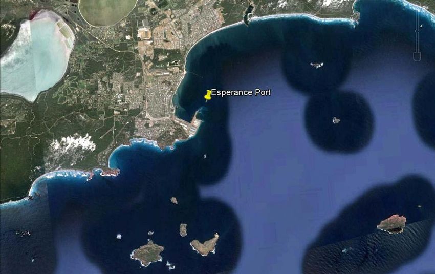
Figure 2.3     Esperance Yacht Club Pens

Figure 2.4     Esperance Yacht Club Wharf and Crane

2.2.2 Taylor Street Jetty
A small commercial jetty exists on the northern side of the Yacht club breakwater. This jetty is
known as Taylor Street Jetty and can be seen in Figure 2.5. Two commercial vessels currently
permanently berth against this jetty and use it for pick up and drop off for charters. Currently
Cruise Ship Tenders pull into a pontoon put in place by the Southern Ports Authority at the Yacht
Club wharf and crane adjacent to the Taylor Street Jetty. Figure 2.6 shows the pontoons in place
with a Tender vessel berthed against the pontoon.

m p rogers & associates pl                                Goldfields Esperance Development Commission
                                                            Esperance Cruise Ship Infrastructure Review
                                                                      K1205, Report R601 Rev 0, Page 9
Figure 2.5 Taylor Street Jetty
Figure 2.6 Cruise Ship Tender and Pontoon in Place at Yacht Club Wharf
Further north of the Yacht Club wharf and Taylor Street Jetty is the recreational boat ramp and
finger jetty. This finger jetty structure is quite narrow and due to this is not particularly suitable for
the unloading of elderly passengers associated with cruise ships.
m p rogers & associates pl Goldfields Esperance Development Commission
Esperance Cruise Ship Infrastructure Review
K1205, Report R601 Rev 0, Page 102.2.3 James Street Groyne
The next structure northwards is the James Street Groyne and Swimming Jetty as seen in
Figure 2.7. This groyne acts to hold sand on the northern side of the structure and a swimming
jetty and offshore swimming pontoon is located on the southern side of the structure. This jetty is
not designed to accommodate vessels; however with some modifications it would be possible to
berth vessels in this location.
Figure 2.7 James Street Swimming Jetty
2.2.4 Tanker Jetty
The most notable feature along the Town Esplanade is the historical Tanker Jetty as seen in
Figure 2.8. The Tanker Jetty is approximately 500 m long and is constructed from timber piles
with a concrete deck. The Tanker Jetty is in a degraded condition and is close to the end of its
service life.
As with similar grand structures, the Tanker Jetty holds a pride of place with the local community
and is a popular place for recreation, including walking and fishing from the structure. A dive trail
has also been established off the end of the structure which provides additional recreational
opportunities as well as preserving some of the heritage of the Tanker Jetty.
m p rogers & associates pl Goldfields Esperance Development Commission
Esperance Cruise Ship Infrastructure Review
K1205, Report R601 Rev 0, Page 11Figure 2.8 Esperance Historical Tanker Jetty
2.2.5 Bandy Creek Boat Harbour
Approximately 6 kilometres out of town is the commercial marina at Bandy Creek. This is
primarily where the commercial fishing vessels are berthed. The fixed pens and breakwater
entrance of Bandy Creek can be seen in Figure 2.9 and 2.10 respectively.
Figure 2.9 Bandy Creek Commercial Boat Harbour Pens
m p rogers & associates pl Goldfields Esperance Development Commission
Esperance Cruise Ship Infrastructure Review
K1205, Report R601 Rev 0, Page 12Figure 2.10 Bandy Creek Commercial Boat Harbour Entrance
2.3 Tidal Range
The maximum tidal range at Esperance can be up to 1.4 m and the tides are largely diurnal.
Typically the daily tidal range is about 0.5 m to 1 m.
2.4 Typical Wind and Wave Conditions
Esperance is located on the southern Western Australian coastline in the Southern Ocean. The
region is renowned for large open ocean swells and strong winds.
The setting of the town facing directly east and the location of the Port’s breakwaters provides
some protection to the town beaches. This shelters the Town beaches from the direct impact of
westerly seas and swells. However, large southerly swells are able to refract in nearshore waters
and then diffract around the Port’s breakwaters. These diffracted swells generally impact the Port
and the Town beaches.
Strong westerly breezes associated with the passing of low pressure systems generally blow
offshore, however the Town’s beaches are directly open to any wind and sea action generated by
breezes with any easterly component.
The local sea breeze typically comes from a SSW to SE direction and can be regularly of the
order of 15 to 20+ knots. This can generate significant local seas.
Typical morning land breezes blow from a NE direction. A summer pattern is for a N to NE land
breeze, followed by an afternoon sea breeze from the S to SE direction.
Winter winds are generally quite light except for when low pressure systems pass the coastline.
Winds during the passage of low pressure systems are generally from the N through to the W and
can regularly exceed 30 knots. A summary of the wind data recorded at Esperance Port was
kindly supplied by the Southern Ports Authority.
Wave conditions within the Southern Ocean are typically characterised by long periods and large
significant wave heights. Strong winds also generate locally generated large seas.
Esperance town site is provided a degree of protection due to its orientation and protection from
the Port’s breakwaters and the offshore islands. Southern Ports measure wave conditions off the
Port at their navigation Beacon Number 2, the general location of which is shown in Figure 2.11.
m p rogers & associates pl Goldfields Esperance Development Commission
Esperance Cruise Ship Infrastructure Review
K1205, Report R601 Rev 0, Page 13Figure 2.11 Esperance Ports Wave Recording Location Beacon 2
A summary of the wave data since March 2014 was kindly supplied by the Southern Ports
Authority and Grant Ryan of Tremafron Pty Ltd. Wave conditions over the recording period from
March to December 2014 at Beacon 2 are summarised as follows:
Minimum Total Significant Wave Height 0.13 m.
Maximum Total Significant Wave Height 1.37 m.
Average Total Significant Wave Height approximately 0.5 m.
Total Peak Period Range 2 – 21 seconds.
Total Mean Period 2 – 10 seconds.
A plot of the Total Significant Wave Height and Direction data recorded at Beacon 2 is provided in
Figure 2.12. This shows that the majority of the energy at the site is received from the SE swells
and sea breeze.
m p rogers & associates pl Goldfields Esperance Development Commission
Esperance Cruise Ship Infrastructure Review
K1205, Report R601 Rev 0, Page 14TOTAL SIGNIFICANT WAVE HEIGHT
Hs (m)
Figure 2.12 Esperance Ports Wave Recording Location
2.5 Volendam Visit 11/11/14
On the 11 November 2014, the cruise ship Volendam stopped into Esperance to anchor offshore.
On the day conditions were deemed too dangerous in which to transfer passengers via Tender
into shore. Subsequently the Volendam pulled anchor and sailed past the Port.
The wave conditions on the day of the Volendam could be used as an initial criterion in which to
assess what conditions are unsuitable for cruise ships to Tender passengers into shore.
Conditions on the day are detailed in the following sections.
2.5.1 Waves
Total Significant Wave Height was approximately 0.3 m throughout the morning until
approximately 3 pm when the wind strength increased and wave heights subsequently rose to a
peak of 0.55 m by 6 pm, before rapidly falling again back to 0.3 m by midnight.
Peak wave periods were approximately 12 seconds (consistent with swell waves). The increase
in wind strength during the afternoon increased the shorter period sea component and reduced
peak wave periods to around 4 seconds. A plot of Total Significant Wave Heights and Peak
Periods on the day is provided in Figure 2.13.
m p rogers & associates pl Goldfields Esperance Development Commission
Esperance Cruise Ship Infrastructure Review
K1205, Report R601 Rev 0, Page 15Figure 2.13 Total Significant Wave Height and Total Peak Period at Beacon 2 on
11/11/14
2.5.2 Winds
Winds recorded by the Bureau of Meteorology Esperance site day were a mild SW 19 km/hr (~ 10
knots) at 9 am with winds increasing to S 24 km/hr (~13 Knots) at 3 pm. Maximum winds
recorded on the day was 41 km/hr (22 knots) at 3.15 pm.
It is noted that these were recorded at the Bureau of Meteorology Weather station and winds
offshore could have been significantly stronger.
2.5.3 Cruise Ship Tender Criteria
Conditions during the morning (from 5 am to 12 pm) had a Total Significant Wave Height of
approximately 0.3 m with Total Peak Periods on average 12.6 seconds.
Using these two values as a limit, the wave record provided by Southern Ports was briefly
analysed for the number of days that would be unsuitable for cruise ships to transfer passengers
by Tender.
Wave records from the Port were only available from March to December this year (approximately
270 days of data). Based on these wave conditions experienced during the Volendam, the criteria
for Tendering passengers would have been exceeded on approximately 155 days out of the 270
days. This suggests that conditions would be unsuitable for the Tendering of passengers
approximately 57% of the time.
m p rogers & associates pl Goldfields Esperance Development Commission
Esperance Cruise Ship Infrastructure Review
K1205, Report R601 Rev 0, Page 16Acceptable criteria may vary from ship to ship. Factors such as Tender vessel sizes and predicted
weather conditions for the next 24 hours would be expected to affect the decision whether to
disembark passengers. It is noted that weather conditions worsened in the afternoon on the day
of the Volendam, which may have also impacted the Captain’s decision that it was unsafe to
unload passengers.
Anecdotal discussions with staff from Southern Ports indicated that travelling within one of the
Volendam’s Tenders on the day was a significantly rough ride to shore from the vessel and would
have been difficult with elderly passengers.
Given the relatively moderate ocean conditions and rough Tender ride on the reasonably short
voyage from the anchored Volendam to shore, in conjunction with the number of days that this
baseline criteria is exceeded, it is recommended that strong consideration be given to a proper
berth at the Port for cruise ships.
2.6 Existing Cruise Ship Facilities
Cruise companies have informed Tourism WA that Esperance is a preferred stopover location over
other south coastal Ports when they are travelling westwards from Adelaide. This provides
Esperance with a significant advantage over the Port of Albany and Augusta Boat Harbour.
Cruise ships voyages are defined by costs and fuel is a major factor in determining voyage costs.
Esperance has an advantage over Albany as it is within a suitable economical fuel range for
cruise vessels when ships are travelling from Adelaide at a travelling speed of approximately
20 knots. Esperance is an approximate 48 hour sail from Adelaide, allowing the ship to arrive and
anchor overnight and passengers to disembark in the morning.
Berthing fees also add significantly to the Cruise Ship’s costs. If the costs to the Cruise Ship are
marginal to a voyage, a vessel may wish to anchor and Tender passengers ashore rather than
paying for tug, berthing and pilotage fees.
Currently vessels at Esperance can berth by either of the following methods:
Anchor and Tender passengers ashore.
Utilise a Berth at the Port, typically Berth 1 (Larger ships greater than 300 m in length or
ships with overhanging decks may not be able to utilise a berth at the Port).
A photograph of Berth 1 and Berth 2 viewed from Taylor Street Jetty can be found in Figure 2.14.
An aerial photograph showing the layout of Esperance Port can be found in Figure 2.15 and a
photograph of a cruise ship anchored offshore from Esperance Port can be seen in Figure 2.16.
m p rogers & associates pl Goldfields Esperance Development Commission
Esperance Cruise Ship Infrastructure Review
K1205, Report R601 Rev 0, Page 17BERTH 2 BERTH 1
Figure 2.14 Esperance Ports Berth 1 & 2
YACHT CLUB &
TAYLOR STREET
JETTY
BERTH 1 BERTH 2
Figure 2.15 Esperance Port Layout
m p rogers & associates pl Goldfields Esperance Development Commission
Esperance Cruise Ship Infrastructure Review
K1205, Report R601 Rev 0, Page 18Figure 2.16 Cruise Ship Anchored in Esperance Bay
Currently Cruise Ships are charged full commercial rates to berth at the Port. While Cruise Ships
provide a boost to the local economy, the Port still incurs costs in providing pilotage, tug services
and occupation of the berth.
None of the berths at the Port at specifically designed for Cruise Ships. Cruise Ships can berth at
any of the Ports three berths, however the land backed wharves of Berth 1 and 2 are more suited.
Typically the Port has utilised Berth 1 for Cruise ships as passengers can be more easily escorted
onto buses. Berth 1 has a size limit of approximately 300 m, therefore larger vessels may not be
able to utilise the Berth.
The Port has some restrictions with Cruise Ships with overhanging decks or life rafts due to the
container and bulk material load out facilities.
When Cruise Ships anchor offshore, they anchor in approximately 10 to 15 m of water depth. The
approximate location is shown in Figure 2.17. Cruise Ships then Tender passengers ashore using
their Tenders (motorised life boats), an example of which can be seen in Figure 2.18 with the
pontoon and gangway arrangement at Taylor Street.
Southern Ports have purchased an approximate 25 m long steel pontoon to enable the berthing of
Tender vessels alongside the Yacht club breakwater at Taylor Street. Currently, the pontoon is
lifted into place each Cruise Ship visit and moored by lines to concrete anchor blocks. This
situation is satisfactory for a temporary solution, however there is a risk that one of the mooring
lines may break free with excessive vessel impact or movement of the pontoon.
m p rogers & associates pl Goldfields Esperance Development Commission
Esperance Cruise Ship Infrastructure Review
K1205, Report R601 Rev 0, Page 19APPROX CRUISE SHIP
ANCHORING LOCATION
Figure 2.17 Approximate Cruise Ship Anchoring Location
TEMPORARY MOORING
ARRANGEMENT
Figure 2.18 Tender Vessel, Pontoon, Gangway and Mooring Arrangement.
m p rogers & associates pl Goldfields Esperance Development Commission
Esperance Cruise Ship Infrastructure Review
K1205, Report R601 Rev 0, Page 20Discussions with officers from the Southern Ports Authority indicates that the Port proposes to
provide permanent piles in this location for the Tender pontoon to save craning the pontoon into
place each cruise ship visit. This would significantly improve the current Tender berthing location.
The Port currently charge a nominal fee for the usage of the pontoons to cover the costs of the
crane required to install and remove the pontoons and two staff to assist with the berthing of the
Tender vessels.
The Port has indicated that in order to avoid Cruise Ships trying to anchor in poor weather to
avoid berthing fees, they may explore opportunities to reduce berthing costs (if a berth is free at
the time). This provides a short term solution for the town to minimise the risk of Cruise Ships
sailing past due to poor weather.
A summary of the advantages and disadvantages of either option are provided in Table 2.1.
m p rogers & associates pl Goldfields Esperance Development Commission
Esperance Cruise Ship Infrastructure Review
K1205, Report R601 Rev 0, Page 21Table 2.1 Advantages and Disadvantages of Berthing Options
Mooring Option Advantages Disadvantages
Berth at Port
Reduced risk of poor weather causing Costs of berthing.
ship to sail past, ship more likely to berth
regardless of weather.
Relatively safe environment to transfer Passengers required to disembark in
passengers. Industrial Port Setting.
May have more people disembark vessel. Passengers required to be transferred by
bus to City.
Waiting times for passengers to be
transferred via bus.
Risk that berth is occupied by another
vessel when cruise ship arrives.
Anchor offshore and Tender
Passengers Ashore
Minimal cost to Cruise Ships. Higher Risk that wind and wave
conditions are too dangerous to transfer
passengers.
Not reliant on a berth being available at Longer transfer time of passengers. May
the Port (in its current configuration). reduce the availability of tours able to be
provided.
Passengers are able to walk directly into Regular vessel ‘sail pasts’ may reduce
Town and back to Tender Vessels. communities active involvement in
assisting cruise ships and negative
sentiment with commercial businesses.
Southern Ports already has suitable Southern Ports Pontoon location is
pontoons for Tender berthing. Provided temporary only, and is required to be
as an “in kind” donation to the lifted in and out with a crane each visit.
community. Currently this cost is largely borne by the
Southern Ports Authority. Pontoons tied
off to mooring blocks and trucks on shore
to stabilise.
Pontoon arrangement is reasonably safe Current temporary pontoon mooring
way to transfer passengers. arrangement is not ideal.
Suitable areas for tour bus pick ups and South to North Easterly winds may pose
turn arounds. an issue for Tender berthing against the
pontoon and wave actions.
Suitable grassed areas to establish Risk that passengers disembark in calm
market stalls and welcoming stalls. weather and then weather comes up in
afternoon and too rough to reboard the
cruise ship offshore.
m p rogers & associates pl Goldfields Esperance Development Commission
Esperance Cruise Ship Infrastructure Review
K1205, Report R601 Rev 0, Page 223. Comparison with Other Ports
Tourism WA produced a document titled;
“Western Australian Cruise Shipping Strategic Plan 2012 -2020”.
Within this document, Tourism WA undertook an assessment of the current cruise ship Ports
around Western Australia and rated each High(H), Medium (M), or Low(L) based on a number of
key business areas. These factors are:
Destination Awareness and Marketing.
Port Infrastructure and Policy.
Industry Capacity and Ownership.
Landside Destination and Development.
The combination of these ratings then ranked each Port against a classification system which
summarised the capabilities of the Port and associated Tourism Sector. Ports where divided into
3 classifications as below:
Tier 1 Port.
Tier 2 Port.
Tier 3 Port.
A Tier 1 port is classified as a turn around port, in that they score highly in the four business areas
and have sufficient infrastructure to be able to reprovision large Cruise Ships with all required
supplies and fuel between cruises. The destination is typically an international air gateway.
A Tier 2 port scores on average a medium across the four criteria. They generally have a high
degree of port infrastructure to support visitation but lack the tourism infrastructure, industry
capacity or destination awareness among the cruise industry. Alternatively the destination has a
high level of destination awareness and industry capacity but lack the port infrastructure to rate
highly across all four criteria.
Tier 3 ports score on average a low rating across the four business areas. These Ports may
provide a medium level of port infrastructure but destination marketing and awareness is low and
industry capacity and tourism destination infrastructure is low.
Fremantle and Broome are likely to be the only Tier 1 ports in the coming 5 plus years in Western
Australia.
All of Western Australia’s Cruise Ship Ports and their associated rankings (as detailed by Tourism
WA 2012) are provided in Table 3.1.
m p rogers & associates pl Goldfields Esperance Development Commission
Esperance Cruise Ship Infrastructure Review
K1205, Report R601 Rev 0, Page 23Table 3.1 Tourism WA Rating of Cruise Ship Ports (TWA 2012)
Port Destination Port Industry Landside Tier Ranking
Awareness and Infrastructure Capacity and Destination
Marketing and Policy Ownership Development
Fremantle H H H H 1
Broome H M M M 2
Bunbury M M H M 2
Albany M M M M 2
Esperance M L M L 2
Geraldton M L M L 2
Exmouth M L L L 3
Port Hedland L M L L 3
Augusta L L L M 3
Note: 1. Table replicated from Tourism WA Cruise Ship Strategy 2012 - 2020
Esperance’s main competitors for the Cruise Ship market on the south coast are Albany and
Augusta. As seen in Table 3.1 Esperance ranks lower than Albany in terms of Port Infrastructure
and Landside Destination Development.
Busselton has recently (as of November 2014) been accepting Cruise Ships and has multiple
visits planned for 2015. Busselton has some significant issues with respect to the anchoring of
the ship and Tendering of passengers inshore, however it has a well established tourism market
and a strong brand awareness with the Margaret River wine region. It is likely that Busselton will
largely become the gateway to the Margaret River region and become a preferred gateway for
cruise ships to this south west region over Bunbury and Augusta.
3.1 Albany
Albany Port enables the berthing of Cruise Ships using the land backed wharves Berth 1 or Berth
2. These berths are also the closest to Town and have no height or overhanging restrictions as no
loaders or cranes are present at these berths. Longer Cruise Ship vessels will have some turning
basin restrictions.
m p rogers & associates pl Goldfields Esperance Development Commission
Esperance Cruise Ship Infrastructure Review
K1205, Report R601 Rev 0, Page 24Figure 3.1 Cruise Ship Berthing at Albany Port
Albany Port provides reduced berthing costs to Cruise Ships and covers the cost of a port to town
shuttle bus. The provision of the free shuttle also assists in managing the security issues of
having passengers within a Port environment.
Albany Port and the City of Albany have also recently installed a new footpath from the Port to link
into paths around the new Waterfront development, Albany Entertainment Centre and onto the
Town centre for passengers wishing to walk. Berths 1 and 2 allow this due to the close proximity
to the Port gates, where passengers can be carolled onto the pathway quite easily. This walk into
town is approximately 1.5 km.
The Town provides a pipe band on arrival, markets and live music for the arrival of larger Cruise
Ships.
Albany is able to market itself recently to Cruise Ships on the basis of ANZAC centenary
celebrations. Predominantly it is an alternate stopover to Esperance for vessels travelling
westwards from the Eastern States and South Australia.
Increasing numbers of ships being home based out of Fremantle (such as the Astor) provides the
opportunity for shorter round trip cruises from Fremantle to Albany and Esperance. These cruises
are approximately 5 days long.
Esperance is seen as being behind Albany in terms of port infrastructure and also landside
destination development. A key review of the Esperance Port which provided information to the
Western Australian Cruise Shipping Strategic Plan 2012-2020 indicated the following regarding
Esperance:
While the Port was keen to assist and secure more Cruise Ship visits, the current berths
restricted some vessels with projecting balconies or decks.
Additional dolphins would be required to accommodate some of the larger Cruise Ships.
Tourism products that meet the expectations of all Cruise Ship passengers of all
demographics need to be addressed.
There was a lack of ground transportation within the town.
m p rogers & associates pl Goldfields Esperance Development Commission
Esperance Cruise Ship Infrastructure Review
K1205, Report R601 Rev 0, Page 25However Cruise Ships companies have indicated that Esperance has an advantage over Albany in
terms of it being a more suited location in their voyage planning.
Discussions with stakeholders suggests that the visitor experience is significantly improved since
Tourism WA’s review in 2012, however there is still significant potential for further improvement.
Development of suitable port infrastructure and landside destination development would elevate
Esperance to a similar level to Albany, although it is likely to remain long term as a Tier 2 port.
Should Esperance prefer to continue to Tender passengers ashore, it will likely fall behind Albany
in terms of the level of port infrastructure and there will always be a significant risk that the
weather is too poor to transfer passengers.
Regardless if infrastructure is provided to make the shore to Tender transfer safer, the ship to
Tender transfer is always going to be the greatest risk as the Cruise Ship itself is anchored in
more exposed waters. In order to remove this risk, Esperance would need to provide a similar
permanent Cruise Ship berth to that of Albany in close proximity to the town centre.
Esperance has recently seen the situation where a Port berth was made available to a cruise ship,
however the ship chose to Tender passengers ashore to avoid having to pay berthing charges.
The weather on arrival of the ship was poor and the decision was made by the cruise ship
company to sail past Esperance.
This highlights another risk in dealing with Cruise Ships. If costs on a Cruise Ship voyage are
marginal, Cruise Ship companies may choose not to take up a Port berth due to the significant
costs it adds to the voyage costs. The risk is that costly infrastructure is put in for Cruise Ships
and then Cruise Ships do not take up the berth.
In order to avoid this situation, it is recommended that any item of infrastructure put in for Cruise
Ships should have another main use and is able to accommodate Cruise Ships for the short
periods of the year when they arrive. Business cases for infrastructure worth millions of dollars is
unlikely to be feasible for the 3 or 4 cruise vessels Esperance currently sees.
It is recommended that any potential new berth that is required at the Port is able to accept Cruise
Ships in conjunction with another primary use.
Similarly to Albany Port, berthing fees for Cruise Ships may have to be adjusted to ensure that the
Port covers its costs of the infrastructure, pilotage and tug services, but are not significant enough
that it deters Cruise Ship companies from using the facility.
3.2 Augusta
The other south coast port for Cruise Ships is Augusta. Augusta has recently built a recreational
marina and installed a large floating pontoon suitable for the berthing of Cruise Ship Tenders. As
with Esperance, Cruise Ships are required to anchor offshore and then Tender passengers
ashore.
While Augusta has several advantages in short Tender distances, the anchoring location is quite
exposed. Augusta Marina is also a long way out of town and passengers have no option other
than to be shuttled into Town approximately 4 kilometres away. The majority of tours at Augusta
would be into the Margaret River wine region.
m p rogers & associates pl Goldfields Esperance Development Commission
Esperance Cruise Ship Infrastructure Review
K1205, Report R601 Rev 0, Page 26It is thought that Esperance has significant benefits over that of Augusta in terms of options for
passengers to walk directly into town, tourism industry capacity and destination awareness.
Esperance having the Port as a potential berthing option would provide an additional advantage
over Augusta.
3.3 Geraldton
Geraldton is another Tier 2 Port which services Cruise Ships on passing voyages as they travel
northwards to Broome and also potentially for round trip 5 days tours out of Fremantle.
Geraldton is a larger port than Esperance and while it is able to accept Cruise Ship vessels, there
are conflicts with tourists being inside the working port.
Cruise ships calling into Geraldton now prefer to anchor offshore and transfer passengers via
Tender into the marina, where a floating pontoon has been installed to accept cruise ship Tenders.
This also provides passengers with a better experience rather than disembarking in an industrial
setting.
Passengers arriving into Geraldton had little knowledge of what there was to undertake within the
town and there are also transportation issues. Geraldton aimed to improve the lack of
understanding by providing a full time cruise ship coordinator within the town to assist in
organising tours.
Esperance provides similar services to that of Geraldton, although it would be expected that
Esperance provides greater tourism opportunities over that of Geraldton. It is thought Esperance
would only be competing with Geraldton on the short tours out of Fremantle.
3.4 Estimated Number of Cruise Ships Visits
Information regarding the number of planned Cruise Ship visits for previous years and out to 2016
was sourced from Tourism WA and is summarised in Table 3.2.
Ports that Tender passengers to shore are prone to visits being cancelled as the vessel is offshore
due to poor weather conditions. Esperance experienced a sail past of the Volendam in November
2014 and Exmouth is also prone to the sail past of vessels due to poor weather conditions from
strong winds and locally generated seas.
The time taken to disembark passengers, sufficient time onshore and then the tendering process
of passengers back onto the vessel is significant. Due to the tight timeframes of the voyage plan
to ensure they maintain schedule to the next port, the Cruise Ships don’t have the ability to wait
offshore for several hours or days until the weather conditions improve.
m p rogers & associates pl Goldfields Esperance Development Commission
Esperance Cruise Ship Infrastructure Review
K1205, Report R601 Rev 0, Page 27Table 3.2 Estimated Number of Cruise Ship Visits to WA Ports
Port 2009/10 2010/11 2011/12 2012/13 2013/14 2015 2016
(planned) (planned)
Fremantle 39 29 39 17 33 51 17
Broome 19 15 25 11 13 14 4
Bunbury 9 9 7 0 3 0 0
Albany 11 9 8 7 7 9 1
Esperance 2 3 4 4 4 8 3
Geraldton 20 19 19 11 5 17 4
Exmouth 5 5 7 2 1 3 4
Port Hedland 0 0 0 4 4 5 1
Augusta
Busselton 1 6 3
Note: 1. Cruise Ship information numbers provided by Tourism WA.
2. Supplementary numbers provided from Cruising Down Under summary reports.
3. Augusta has only recently opened in the year 2014
4. Busselton’s first cruise ship arrived offshore November 2014.
Albany has approximately 7 to 11 vessels visit the town each year.
Esperance currently averages 2 to 3, with 2014 expected to have approximately 4 vessels and 8
vessels currently planned for 2015. The increased demand for berthing at Esperance in 2015
indicates that it is likely able to match Albany in terms of average numbers of visits per year with
increasing numbers of Cruise Ships sailing in Western Australian waters.
m p rogers & associates pl Goldfields Esperance Development Commission
Esperance Cruise Ship Infrastructure Review
K1205, Report R601 Rev 0, Page 284. Summary of Esperance Existing Situation
A summary of Esperance’s existing Cruise Ship facilities and procedures and possible
opportunities or risks are detailed below.
4.1.1 Strengths
Aesthetically a spectacular bay for Cruise Ships to anchor in.
Cruise Ships are able to easily anchor close to shore and transfer passengers via Tender
vessels.
Port has already purchased and uses suitable steel pontoons for the landing of Tender
vessels.
Tender Pontoon location at Taylor Street (in front of Yacht Club) is relatively protected.
Port provides alternative berthing opportunity if required.
Established Cruise Ship Committee to coordinate stakeholders and necessary preparation
and planning for cruise ship arrivals.
Multiple eco tourism opportunities. Explore islands, Pink Lake, local beaches and National
Parks (Cape Le Grand), dive tours on Tanker Jetty.
Current Taylor Street location has room for bus tours to pick up and drop off passengers.
Passengers able to relatively easily walk throughout town. Local Historical Museum Village
is within walking distance. Other tourism opportunities (eg replica Stone Henge requires
transport).
4.1.2 Weakness
Esperance Port is not specifically setup to accept cruise ships.
Should a Cruise Ship berth at the Port, passengers are required to be transported from Port
to Town which reduces time available for tours and in town.
Lack of transport infrastructure (lack of buses in town).
Poor pedestrian links to town from pontoon Tender landing location at the Yacht Club.
Minimal toilets, shade and landscaping around the Taylor Street location.
Recent foreshore landscaping works do not link into Tender pontoon location at Taylor
Street.
Landscaping works focussed up at Tanker Jetty Headland and James Street, which acts to
draw people away from the Town Centre at Andrew Street.
4.1.3 Opportunities
Geographic advantage in terms of location over other south coast ports for ships travelling
from the East coast. Cruise Ship companies have identified Esperance as a preferred stop
over location.
m p rogers & associates pl Goldfields Esperance Development Commission
Esperance Cruise Ship Infrastructure Review
K1205, Report R601 Rev 0, Page 29 Increasing Cruise Ship market and demand within Australia.
Increasing number of Cruise Ships being home based out of Fremantle. Opportunities for
short round trip south coast cruises such as Fremantle - Esperance – Albany – Fremantle.
Opportunity to increase average numbers of visits from approximately 3 to approximately 8.
Port has room to expand to accommodate a multi user berth that could accommodate
Cruise Ships. The provision of a berth reduces the risks that ships sail past due to poor
weather.
Location of Yacht club breakwater is such that a facility in this location is outside of the
Ports security zone. Reduced security and safety requirements for dealing with passengers
from the Cruise Ship.
Opportunity for a large multi user jetty structure to provide an additional berth for the Port
and also provide for cruise ships for the benefit of the Town. If this facility is able to be
utilised by the public when not in use it could also act as a replacement for the degradation
of the existing Tanker Jetty structure.
Yacht club marina and breakwater requires upgrade or replacement. Opportunity to
relocate and to involve the marina into the Esplanade foreshore to form a southern extent
for the Esplanade foreshore with the Tearooms and Yacht club.
Port may review berthing fee structure for Cruise Ships.
4.1.4 Threats
The major threat is that Cruise Ship companies decide to minimise numbers of voyages
within Australian waters, or there is an economic down turn which reduces passenger
numbers significantly.
Relying on Cruise Ships to Tender passengers ashore. There is a risk of ships sailing past
due to poor weather and sea states and therefore not being able to Tender passengers
ashore. A brief analysis of a limited wave record provided by Southern Ports Authority
indicates that conditions may be unsuitable for Tendering approximately 57% of the time.
Multiple sail pasts of Cruise Ships may cause negative sentiment with the community
volunteers and local businesses.
Risk that weather is fine in the morning and then turns worse in the afternoon and
passengers are unable to get back onto the Cruise Ship via tenders.
Albany becomes a preferred port over Esperance as berthing at the Port is guaranteed.
This means that Cruise Ships visiting Albany do not have to tender passengers ashore and
passengers are Poor weather impacting visitor’s perception of the area.
Demand for Port capacity is increased and the option to berth Cruise Ships within the Port
is reduced. Cruise Ships would then have to rely on tendering passengers.
Port Berthing fees are kept at levels too high for Cruise Ships to justify berthing.
m p rogers & associates pl Goldfields Esperance Development Commission
Esperance Cruise Ship Infrastructure Review
K1205, Report R601 Rev 0, Page 304.1.5 Summary
In general, Esperance appears to have good potential to increase the amount of Cruise Ship
tourism within the town. This is particularly as it sits in a location that suits many of the Cruise
operators when travelling from the eastern coastline.
While berthing at the port is an option, it is not preferred by the Cruise Ship companies due to
high berthing fees, the lower ambience for passengers disembarking within an industrial setting
and also there are security and safety issues within the Port which require passengers to be
transferred into Town via a shuttle bus. Currently there is a lack of transport infrastructure within
the Town to be able to accommodate the shuttle bus and the additional tours.
Esperance has an advantage in that deep and reasonably protected waters are relatively close to
shore. This makes Tendering passengers ashore a viable option for Cruise Ship companies. The
risk is that weather and sea state conditions have to be quiet mild in order to transfer passengers,
transport them to shore in the tenders and then disembark them onto the shore. Should the
conditions note be suitable, the tight timeframes of the Cruise Ships are such that the vessels are
required to ‘sail past’.
Esperance Ports has already purchased a large steel pontoon structure which is installed to allow
for the easy transfer of passengers to shore at the small yacht club wharf at Taylor Street (Figures
4.1 and 4.2). This location is reasonably well protected by the larger Taylor Street commercial
charter jetty and the yacht club marina breakwater. The Tendering of passengers ashore is
sufficiently cheaper for the Cruise Ships as they don’t incur berthing or tug costs.
Figure 4.1 Esperance Port Existing Pontoons and Gangway
m p rogers & associates pl Goldfields Esperance Development Commission
Esperance Cruise Ship Infrastructure Review
K1205, Report R601 Rev 0, Page 31Figure 4.2 Tender Vessel and Pontoons in Place
Currently the walk from the Tender Pontoon to the Town centre is around the back of the Yacht
club as seen in Figure 4.3. This area is generally ‘plain’ and it is unclear as to where the Town
centre is, which gives passengers a perception of a long distance.
This area was not included in the recent landscaping upgrades to the Esperance Esplanade.
A small ablution block and some small shade shelters are situated in close proximity to the Tender
pontoon location. There is good access for Tour buses to pick up and drop off passengers.
m p rogers & associates pl Goldfields Esperance Development Commission
Esperance Cruise Ship Infrastructure Review
K1205, Report R601 Rev 0, Page 32Figure 4.3 Cruise Ship Passengers Current Walk into Town Centre
A summary of the infrastructure items and their various strengths, weaknesses, opportunities and
threats are provided in Table 4.1.
m p rogers & associates pl Goldfields Esperance Development Commission
Esperance Cruise Ship Infrastructure Review
K1205, Report R601 Rev 0, Page 33Table 4.1 Infrastructure Summary
Strength Weakness Opportunity Threat
Location Aesthetically a Esperance Port Geographic advantage for Cruise ship
spectacular bay for is not ships travelling from the companies reduce
cruise ships to anchor specifically East coast. Cruise ship numbers of voyages
in Esperance Bay. setup to accept companies have identified within Australian
cruise ships. Esperance as a preferred waters.
stop over location.
Methodology Cruise vessels able to Should a cruise Port has room to expand to Relying on ships to
easily anchor close to ship berth at the accommodate a multi user tender passengers
shore and Tender Port, berth that could ashore. There is a
passengers. passengers are accommodate cruise ships. risk of ships sailing
required to be The provision of a berth past due to poor
transported from reduces the risks that ships weather and sea
Port to Town sail past due to poor states and therefore
which reduces weather. not being able to
time available Tender passengers
for tours and in ashore.
town.
Tender Pontoon Permanent Piles to reduce Multiple sail pasts of
location at Taylor pontoon movements (make ships due to poor
Street (in front of safer for passengers) and weather may cause
Yacht Club) is also reduce costs incurred negative sentiment
relatively protected. by Port for each ship visit. with the community
volunteers and local
businesses.
Existing Port provides Lack of transport Location of Yacht club Albany becomes a
Infrastructure alternative berthing infrastructure breakwater is such that a preferred port over
opportunity if required. (lack of buses in facility in this location is Esperance due to
town). outside of the Ports security better levels of
zone. Reduced security infrastructure and less
and safety requirements for weather risks.
dealing with passengers
from the cruise ship.
Port has already Yacht club marina and .
purchased and uses breakwater requires
suitable steel upgrade or replacement.
pontoons for the
landing of Tender
vessels.
Economics & Tendering option is Port berthing Port may review berthing Port Fees are kept too
Costs cheap for cruise fees for a cruise fee structure for Cruise high for cruise ships to
companies. ship are full Ships. justify berthing.
commercial
rates.
. Opportunity to increase
average numbers of visits
from an average of 3/yr to
8/yr similar to Albany.
m p rogers & associates pl Goldfields Esperance Development Commission
Esperance Cruise Ship Infrastructure Review
K1205, Report R601 Rev 0, Page 345. Potential Infrastructure Locations
Esperance has a number of facilities that could assist in improving the experience for Cruise Ship
passengers and making the transfer of passengers as safe and efficient as possible. Options for
infrastructure upgrades are explored below.
Sketches of the concepts can be found in Appendix A.
5.1 Bandy Creek
Whilst Bandy creek is a commercial marina and would provide safe environment in which to
transfer passengers to and from Tender vessels, it is a significant distance out of town.
Passengers would have to be transported into and out of town.
The area is also more of a commercial setting and therefore would not provide a great initial
ambience for Cruise Ship visitors.
It is not believed that Bandy Creek would be a suitable location for the development of additional
infrastructure to benefit Cruise Ships.
5.2 James Street
The groyne at James Street would be the closest entry point for Cruise Ship visitors into town. A
facility in this location would be an approximate 300 m walk to the roundabout on the foreshore at
Andrew Street.
Existing infrastructure at James Street includes the existing rubble mound groyne, a swimming
jetty and a swimming pontoon on the southern side of the groyne.
The groyne and swimming jetty at James Street is in a slightly more exposed location than the
current commercial jetty at Taylor Street. The jetty structure at James Street is not designed to
handle vessel loads, therefore any additional structures designed to utilise the existing jetty
should be structurally isolated, such that no additional loads or deflections due to vessel impacts
are imparted onto the existing James Street jetty structure. It would be possible to make use of
the existing jetty structure as a walkway.
In order to berth Tender vessels at James street, one of the following new items of infrastructure
would be required:
A fixed jetty structure with a lower landing suitable for the berthing of Tender vessels.
A floating pontoon structure.
m p rogers & associates pl Goldfields Esperance Development Commission
Esperance Cruise Ship Infrastructure Review
K1205, Report R601 Rev 0, Page 35Figure 5.1 James Street Groyne and Swimming Jetty
A floating pontoon structure requires a modest wave climate so that the floating pontoon is not
subjected to large movements which cause damaged to the pontoon structure and the piles.
Therefore, if a floating pontoon type structure is utilised at James Street, an extension to the
existing groyne would be required to provide adequate protection to the pontoon. A concept
something similar to that seen in Figure 5.2 (Appendix A Concept Option 2) would likely be
suitable at James Street.
m p rogers & associates pl Goldfields Esperance Development Commission
Esperance Cruise Ship Infrastructure Review
K1205, Report R601 Rev 0, Page 36Figure 5.2 James Street Floating Tender Pontoon Concept
Current pontoons utilised by the Port at Taylor Street appear to be suitable for installation at
James Street. The design wave height capacity of the existing pontoons would need to be
confirmed in order to design the appropriate length breakwater extension.
It should be noted that the proposed breakwater extension shown in Figure 5.2 is likely to result in
some realignment of the beach. This would need careful investigation during the breakwater
design.
The alternative option is to install an additional fixed jetty section with a lower level landing which
is suitable for swimming and doubles as a Tender vessel berthing point. An example of this
concept is provided in Figure 5.3.
Advantages of a fixed jetty solution are that the wave climate is not required to be reduced by an
extension to the breakwater to maintain structural integrity. However the disadvantage is that at
some times the wave conditions may be too dangerous to berth a vessel against the fixed
structure and at some tides there may possible be a step between the vessel and the jetty
platform.
m p rogers & associates pl Goldfields Esperance Development Commission
Esperance Cruise Ship Infrastructure Review
K1205, Report R601 Rev 0, Page 37Figure 5.3 Example Fixed Lower Level Vessel Landing
The issue with a tidal difference is not expected to be a large issue as staff from the cruise vessel
would be available to assist passengers onto the jetty from the Tender vessel, or alternatively
there could be landings at different heights to accommodate various tide and vessel sizes. In
conditions where the waves are too dangerous to berth a vessel at Taylor Street, it is unlikely that
the cruise ship would be able to transfer passengers offshore from the Ship to the Tender anyway.
It is recommended that any new structure for Cruise Ships provide universal access down to the
lower level landing or pontoon. Grades for universal access are typically 1 vertical to 14
horizontal, therefore a significant ramp structure is likely to be required.
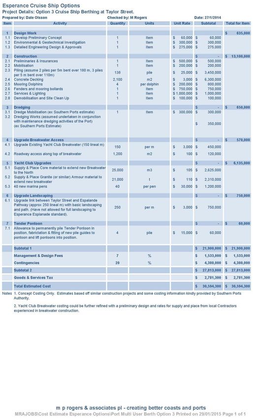
5.2.1 Estimated Costs
A concept cost estimate has been prepared on an option of utilising the existing Southern Ports
Pontoons at James Street for the berthing of Tender vessels only.
The option would require a breakwater extension to provide a reduced wave climate for the
pontoon, a fixed jetty section that ramps down to the water level, a gangway onto the floating
pontoons and piling for the pontoons.
Several elements would require further investigation and preliminary and detail design, including
the breakwater extension, investigate the impacts of the breakwater extension on the adjacent
beaches and the structural elements of the jetty and the pontoon piles.
m p rogers & associates pl Goldfields Esperance Development Commission
Esperance Cruise Ship Infrastructure Review
K1205, Report R601 Rev 0, Page 38m p rogers & associates pl Goldfields Esperance Development Commission
Esperance Cruise Ship Infrastructure Review
K1205, Report R601 Rev 0, Page 395.3 Taylor Street
The Taylor street location is the current Tendering location for Cruise Ships. It is less exposed
than the groyne at James Street and is adjacent to the existing commercial Taylor Street jetty.
Esperance Ports currently proposes to install some permanent piles for the pontoon and maintain
the pontoon in place for the majority of the year. This will significantly reduce the movements of
the pontoon making it safer during vessel berthing and when disembarking passengers. Siltation
of this berth may occur from time to time, which may have to be managed by some minor
excavation or dredging works.
The Taylor Street location provides good tour bus access which is significant for Cruise Ship
passengers.
There is an opportunity to improve the Cruise Ship passengers experience by providing a
pedestrian link across the front of the yacht club into the Town Centre. The distance to the
roundabout at Andrew Street is approximately 500 m using this route across the front of the Yacht
Club.
A link across the front of the Yacht Club would provide opportunity for markets / stalls and tourism
information along the grassed area. Figure 5.4 (Appendix A Concept Option 1) provides an
indicative pedestrian link across the Yacht club grounds.
Figure 5.4 Concept Option 1 - Taylor Street Pontoon and Proposed Pedestrian
Link
m p rogers & associates pl Goldfields Esperance Development Commission
Esperance Cruise Ship Infrastructure Review
K1205, Report R601 Rev 0, Page 40You can also read


