www.kit.edu - RESEARCH REPORT 2015 2016 - cedim (kit)
←
→
Page content transcription
If your browser does not render page correctly, please read the page content below
RESEARCH REPORT 2015 - 2016

KIT – The Research University in the Helmholtz Association                 www.kit.edu
Content                                                                              3

Content

   Imprint...................................................................................................................................... 5

   Preface...................................................................................................................................... 6

   Vorwort..................................................................................................................................... 8

I. FDA Activities............................................................................................................10

   FDA Reports............................................................................................................................ 10

       CEDIM Investigations on the 2015 Nepal Earthquake........................................................................... 10

       Severe Thunderstorm Episode May/June 2016 Germany...................................................................... 13

       Hurricane Matthew, September 2016.................................................................................................. 15

   Short Reports.......................................................................................................................... 17

       Earthquake Amatrice 2016.................................................................................................................. 17

       Excessive Rain in Southern Germany, 19. - 21. November 2015........................................................... 18

       Lefkada Earthquake Greece 2015........................................................................................................ 20

       Illapel Earthquake Chile 2015.............................................................................................................. 21

II. Research....................................................................................................................22

   CEDIM Projects........................................................................................................................ 22

       Crowdsourcing - Using Social Media for Rapid Damage Assessment.................................................... 22

       Improving Communication with the Public during Disaster Situations.................................................. 23

       Towards the Development of a Global Tsunami Risk Model.................................................................. 25

       The Web Service “Wettergefahren-Frühwarnung”/ Weather Hazards - Early Warning.......................... 27

       ATMO Forensic Prediction and Analysis - Winter Storms in Germany.................................................... 29

   New CEDIM Projects................................................................................................................ 31

       Resilience of Cities in the Course of Time............................................................................................. 31

       Critical Social Interactions in Case of Emergency - Vulnerabilitiy of the Chilean Street
       Network to Social Interaction in Case of Emergency of Natural Disasters.............................................. 32

       Effects of Extreme Events on EMI-Systems........................................................................................... 33

       Energy Risks toward 2025................................................................................................................... 34

       Earthquake Aftershock Modeling........................................................................................................ 36

       Loss Estimation and Analysis................................................................................................................ 37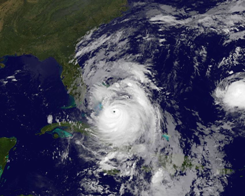
4                                                                            Content

    III. Cooperations and Outreach...................................................................................39

       Research Institutions................................................................................................................ 39

           University of Adelaide.......................................................................................................................... 39

           Institute for Environmental Studies, VU University Amsterdam............................................................. 39

           Deltares............................................................................................................................................... 39

       Insurance Industry................................................................................................................... 39

           Willis Research Network (WRN)........................................................................................................... 39

           Sparkassenversicherung SV.................................................................................................................. 40

       International Programs............................................................................................................ 41

           IRDR International Center of Excellence............................................................................................... 41

           WMO’s High Impact Weather Project HIWeather................................................................................. 41

           CEDIM and the World Bank & GFDRR (Global Facility for Disaster Reduction
           and Recovery)..................................................................................................................................... 41

           GADRI................................................................................................................................................. 42

       Spin-Off Company Risklayer................................................................................................................ 42

       Outreach................................................................................................................................. 42

           European Geosciences Union (EGU)..................................................................................................... 42

           Earth System Knowledge Platform ESKP.............................................................................................. 43

           Media Presence (Television, Radio, Print).................................................................................... 43

           FDA and Short Reports........................................................................................................................ 44

           CEDIM at the “The Change Agenda” Symposium in Oxford, England.................................................. 44

       Networking Initiative at KIT...................................................................................................... 44

           Strategic Workshops on „Risks, Catastrophes and Security”................................................................. 44

    IV. Publications 2015 and 2016....................................................................................46

           Articles in Journals and Books 2015..................................................................................................... 46

           Articles in Journals and Books 2016..................................................................................................... 47

           Conference Abstracts 2015................................................................................................................. 48

           Conference Abstracts 2016................................................................................................................. 49

           CEDIM Reports 2015........................................................................................................................... 50

           CEDIM Reports 2016........................................................................................................................... 50
Content                                                  5

Imprint
CEDIM Research Report 2015 - 2016

Editors:        Prof. Dr. Michael Kunz
                Dr. André Dittrich

tech. Assistant: Johannes Hilpert

DOI:            10.5445/IR/1000069933         State: 		        June 2017

CEDIM                                         Cover picture:   Devastated street in Braunsbach,
                                              		               Germany after flood events end of
Center for Disaster Management and            		               May and beginning of June 2016.
Risk Reduction Technology 			                 		               Image by Dr. Andreas Kron
Hermann-von-Helmholtz-Platz 1                 		               Captured 7 June 2016
76344 Eggenstein-Leopoldshafen, Germany
info@cedim.de                                 Printed by:      Systemedia GmbH, Wurmberg
6                                                              Preface

    Preface

    The Center for Disaster Management and Risk                     and flow velocity to draw conclusions about the
    Reduction Technology (CEDIM) is an interdiscipli-               temporal sequence of the event by combining
    nary research institution in the field of disaster              direct observations, statements of individuals
    management. After 10 years of successful coop-                  affected, and video analyses. After Hurricane
    eration with the Deutsches GeoForschungsZen-                    Matthew on 16 September 2016, which caused
    trum Potsdam (GFZ), the Karlsruhe Institute of                  more than 1000 fatalities in Haiti alone, its me-
    Technology (KIT) became solely responsible for                  teorological background and socioeconomic ef-
    CEDIM in January 2016. At present, 16 KIT insti-                fects were analysed.
    tutes participate in CEDIM. This report provides
    an overview of the research work and activities                 In addition to these broad forensic analyses, CE-
    of CEDIM during 2015 and 2016.                                  DIM researchers have examined further extreme
                                                                    events and disasters primarily disciplinarily, which
    For several years, CEDIM’s research has focused                 are also described briefly in Chapter I. This in-
    on Forensic Disaster Analyses (FDA)1 in near-real-              cludes the earthquake in Amatrice (Italy) in Au-
    time. The objectives of this new research are to                gust 2016, with an estimated damage of 2.6
    assess a disaster directly after its occurrence, an-            billion USD, the heavy rain episode of Novem-
    alyse its effects, track its temporal development,              ber 2016 in Germany, the weaker earthquake
    and identify the factors most relevant to its impli-            on Lefkada (Greece) in November 2015 and in
    cations. In the course of a CEDIM FDA-Task Force                the same month, the heavy Mw=8.3 earthquake
    Activity, reports with different foci are written               in Illapel (Chile), where the new Tsunami-model
    contemporaneously, i.e., a few days to weeks                    TsuKIT was applied for the first time. In addition
    after the disaster occurs. In some cases, specific              to these CEDIM short reports, 131 reports about
    field studies on site complement these analyses.                forthcoming extreme or unusual weather events
                                                                    worldwide were published on the web portal,
    Various CEDIM FDA activities have been per-                     “Wettergefahren-Frühwarnung.”
    formed in the last two years, and are described
    in detail in Chapter I. A team of researchers ana-              Different CEDIM projects constitute the scien-
    lysed the effects on various regions of the severe              tific basis of the FDA activities, where methods
    earthquake in Nepal on 25 August 2015, as well                  have been developed or improved during the
    as the intensity and frequency of the aftershocks.              last years to help analyse disasters in near-real-
    During three field studies (June and November                   time, and which are applied in the case of an
    2015; April 2016), different surveys were con-                  FDA activity (Chapter II). Within the scope of a
    ducted on site to shed light on the situation in                project on crowdsourcing, natural disasters are
    the emergency shelters, establish criteria for an               detected, located, and classified in real-time via
    evacuation, and evaluate existing information                   a self-developed software and taxonomy using
    gaps for the public. On this basis, a conceptual                social media posts. Based on past FDA activities,
    model was constructed to assess the vulnerability               a further CEDIM project investigated factors that
    of critical infrastructures and the emergency shel-             hamper effective communication during disas-
    ters, and for emergency planning purposes. With                 ters and lead to significant information gaps,
    respect to the thunderstorm episode in Germany                  and identified the primary reasons for these
    during May/June 2016, which lasted almost two                   situations. Two further projects are designed to
    weeks and caused heavy flooding in many local-                  estimate the risk of winter storms and tsunamis
    ities (e.g., Braunsbach and Simbach), CEDIM’s                   using probabilistic methods. While in the case of
    research focused on analyses of the probability                 winter storms, a simplified approach is used that
    of comparable events in the long-term. Through                  estimates damage by means of the intensity and
    surveys in several municipalities affected, CEDIM               spatial expansion of an event, combined with
    researchers estimated runoff, flood wave height,                data about residential buildings, the estimation
                                                                    of the risk of a tsunami is based on the com-
                                                                    putation of wave propagation using up-to-date
    1
      The term “Forensic Investigation of Disasters” (FORIN) has
    already been coined in 2010 in connection with natural dis-
                                                                    parallel processing hardware.
    asters by the international research programme IRDR/ICSU
    (Integrated Research on Disaster Risk / International Council   Forensic Disaster Analyses also are a focus of
    for Science). IRDR, with its forensic approach, follows up on   the current funding phase 2016-2018. There-
    the question of how natural hazards turn into disasters – or
    not.
                                                                    fore, the research approach has been developed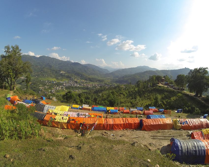
Preface                                                     7

further by integrating social science studies and     tional and international research landscape and
sharpening the profile to include society’s areas     is visible widely to various user groups, such as
of demand of energy, mobility, and information.       the insurance industry, relief organizations, and
The objectives of the new CEDIM projects, which       governmental institutions. With its new focus,
began at the end of 2016 and also are introduced      CEDIM contributes to all three of society’s areas
briefly in Chapter II, are to scrutinize changes in   of demand—energy, mobility, and information—
risk and resilience attributable to social change,    identified by the KIT umbrella strategy 2025, and
especially concerning energy, mobility, and sup-      is thereby in an excellent position to continue to
ply systems, and critical infrastructures in urban    pool risk research at KIT. For this reason, CEDIM,
areas. Work on the effects of natural hazards and     together with the KIT-Center Climate and Envi-
social interactions on the street network of Chile,   ronment, has begun a process to improve the in-
post-disaster rapid loss estimation, and the mod-     tegration and networking of the various research
elling of aftershocks complement these projects.      activities at KIT in the fields of Risks, Catastro-
                                                      phes, and Security, and to develop a common
Several new collaborations were established in        strategy.
the last two years with international research
centers, such as the University of Adelaide, the      Michael Kunz
VU university of Amsterdam, and Deltares, an          Stefan Hinz
independent institute that focuses on water re-       Franz Nestmann
search. Close connections continue with the
insurance industry, especially with the Willis Re-
search Network (WRN), where CEDIM is involved
in a Flagship Project to develop a hail risk model
for Europe and Australia. Further, CEDIM has de-
veloped risk models for both types of hazards,
hail and flood, for the Sparkassenversicherung
SV. CEDIM also has joined various national and
international programs: the IRDR International
Center of Excellence on Critical Infrastructures
and Strategic Planning established in 2015, the
new 10-years-program High Impact Weather of
the World Meteorological Organization (WMO),
and different programs of the World Bank and
the Global Facility for Disaster Reduction and
Recovery (GFDRR). Since 2016, CEDIM has been
a member of the newly founded network, the
Global Alliance of Disaster Research Institute
(GADRI).

Outreach is another important pillar of CEDIM.
This is being promoted actively, for example,
in its own session at the European Geoscience
Union (EGU), by several articles on the website
Earth System Knowledge Platform (ESKP: www.
eskp.de), as well as by numerous contributions in
high-ranking media (e.g., New York Times, Die
Zeit, FAZ, ARD, ZDF, ARTE, Deutschlandradio, and
others). James Daniell, a CEDIM researcher, con-
tributed an article, “Natural Disasters since 1900:
Over 8 Million Deaths and 7 Trillion US Dollars
damage,” that garnered the highest number of
quotations for the KIT in 2016. A summary of
these activities is provided in Chapter III.

With its near-real-time analyses of major dis-
asters, a research program that addresses new
topics repeatedly, and its active public relations,
CEDIM is now established successfully in the na-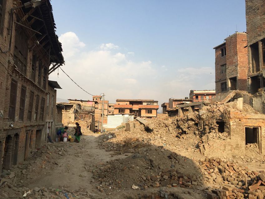
8                                                            Vorwort

    Vorwort

    Das Center for Disaster Management and Risk                   zung der Resilienz kritischer Infrastrukturen, für
    Reduction Technology (CEDIM) ist eine interdiszi-             die Notfallvorsorge und die Vulnerabilität inner-
    plinäre Forschungseinrichtung im Bereich des Ka-              halb der Notunterkünfte. Bezüglich der fast zwei
    tastrophenmanagements. Nach über 10 Jahren                    Wochen andauernden Gewitterepisode im Mai/
    erfolgreicher Kooperation mit dem Deutschen                   Juni 2016 in Deutschland mit schweren Über-
    GeoForschungsZentrum Potsdam (GFZ) ist CE-                    schwemmungen vieler Ortschaften (beispielswei-
    DIM im Januar 2016 in die alleinige Verantwor-                se Braunsbach und Simbach) konzentrierten sich
    tung des Karlsruher Instituts für Technologie (KIT)           die Forschungsarbeiten von CEDIM vor allem auf
    übergegangen. Derzeit sind daran 16 Institute                 Analysen der Wahrscheinlichkeit vergleichbarer
    des KIT beteiligt. Der vorliegende Bericht gibt ei-           Ereignisse in einem langzeitlichen Kontext. Bei Er-
    nen Überblick über die Forschungsarbeiten und                 hebungen vor Ort in mehreren betroffenen Kom-
    Aktivitäten von CEDIM in den Jahren 2015 und                  munen konnten Wissenschaftler des CEDIM aus
    2016.                                                         der Kombination von direkten Beobachtungen,
                                                                  Aussagen von Betroffenen und Videoanalysen
    Seit einigen Jahren liegt der Schwerpunkt der                 Abfluss, Scheitelhöhe und Strömungsgeschwin-
    Forschungsarbeiten von CEDIM auf forensischen                 digkeit schätzen und Rückschlüsse auf die Er-
    Katastrophenanalysen in Nahe-Echtzeit (Foren-                 eignisgenese ziehen. Nach Hurrikan Matthew
    sic Disaster Analysis, FDA)1. Die Ziele dieses For-           im September 2016 mit über 1000 Todesopfern
    schungsansatzes sind es, unmittelbar nach dem                 allein in Haiti wurden in einer weiteren FDA Akti-
    Eintreten einer Katastrophe diese zu bewerten,                vität sowohl die meteorologischen Hintergründe
    die Folgen abzuschätzen, die zeitliche Entwick-               als auch die sozioökonomischen Auswirkungen
    lung nachzuverfolgen und die wichtigsten Fak-                 dieser Katastrophe analysiert.
    toren zu identifizieren, die für die Auswirkungen
    maßgeblich sind. Im Rahmen einer CEDIM FDA-                   Neben den breit angelegten forensischen Ana-
    Task Force Aktivität werden zeitnah, also wenige              lysen untersuchten CEDIM Wissenschaftler
    Stunden bis Tage/Wochen nach dem Eintreten                    weitere Extremereignisse und Katastrophen
    einer Katastrophe, Berichte mit unterschied-                  vor allem disziplinär, die ebenfalls in Kapitel I
    lichen Schwerpunkten verfasst. In einigen Fällen              kurz dargestellt sind. Hierzu zählen das Erdbe-
    werden diese Analysen ergänzt durch spezifische               ben von Amatrice (Italien) im August 2016 mit
    Feldeinsätze vor Ort.                                         einem geschätzten Schaden von 2,6 Mrd. $, die
                                                                  Starkniederschlagsepisode im November 2016 in
    Auch in den vergangenen beiden Jahren kam es                  Deutschland, das schwächere Erdbeben auf Lef-
    zu mehreren CEDIM FDA Aktivitäten, die aus-                   kada (Griechenland) im November 2015 sowie
    führlich in Kapitel I beschrieben sind. So analy-             das schwere Mw=8,3 Erdbeben in Illapel (Chile)
    sierte ein Team von Wissenschaftlern nach dem                 im gleichen Monat, bei dem erstmalig auch das
    schweren Erdbeben in Nepal am 25. April 2015                  eigene Tsunami-Modell TsuKIT zum Einsatz kam.
    detailliert die damit verbundenen Auswirkungen                Neben diesen CEDIM Kurzberichten wurden wei-
    in verschiedenen Regionen und die Intensität und              tere 131 Berichte zu bevorstehenden extremen
    Häufigkeit von Nachbeben. Bei insgesamt drei                  oder ungewöhnlichen Wetterereignissen welt-
    Feldeinsätzen (Juni und November 2015; April                  weit verfasst und über das Webportal „Wetter-
    2016) wurden verschiedene Befragungen vor Ort                 gefahren-Frühwarnung“ veröffentlicht.
    durchgeführt, um die Situation in den Notunter-
    künften näher zu beleuchten, Entscheidungskri-                Die wissenschaftliche Basis der FDA-Aktivitäten
    terien für eine Evakuierung nachzubilden und                  bilden verschiedene CEDIM-Projekte, deren Ziel
    bestehende Informationsdefizite der Bevölke-                  es ist, Methoden zu entwickeln oder zu verbes-
    rung zu eruieren. Darauf aufbauend wurde ein                  sern, mit denen Katastrophen im Rahmen einer
    konzeptionelles Modell erstellt für die Abschät-              FDA Aktivität zeitnah analysiert werden können
                                                                  (Kapitel II). Im Rahmen eines Projekts zu Crowd-
                                                                  sourcing werden Naturkatastrophen in Echtzeit
    1
      Der Begriff “Forensic Investigation of Disasters” (FORIN)
    im Zusammenhang mit Naturkatastrophen wurde im Jahr
                                                                  mit Hilfe einer eigens entwickelten Software und
    2010 durch das internationale Forschungsprogramm IRDR/        Taxonomie aus Beiträgen sozialer Medien detek-
    ICSU (Integrated Research on Disaster Risk / International    tiert, verortet und klassifiziert. In einem weiteren
    Council for Science) geprägt. IRDR untersucht mit Hilfe des   CEDIM-Projekt wird aus vergangenen FDA Aktivi-
    forensischen Ansatzes, wie aus Extremereignissen Katastro-
    phen werden oder nicht.
                                                                  täten untersucht, welche Faktoren eine effektive
Vorwort                                                         9

Kommunikation während einer Katastrophensi-           Impact Weather der World Meteorological Orga-
tuation erschweren und welche maßgeblichen            nization (WMO) und an verschiedenen Program-
Informationslücken aus welchen Gründen vor-           men der World Bank und der Global Facility for
herrschen. Zwei weitere Projekte haben zum Ziel,      Disaster Reduction and Recovery (GFDRR). Seit
das Risiko durch Winterstürme und Tsunamis mit        2016 ist CEDIM außerdem Mitglied des neu ge-
probabilistischen Methoden zu schätzen. Wäh-          gründeten Netzwerks Global Alliance of Disaster
rend im Fall von Winterstürmen ein vereinfach-        Research Institute (GADRI).
ter Ansatz zum Tragen kommt, mit dem aus der
Intensität und räumlichen Ausdehnung eines            Weiterhin ist die Außendarstellung eine wichtige
Sturms zusammen mit Daten über Wohngebäu-             Säule von CEDIM. Dies wird aktiv befördert etwa
de auf den Schaden geschlossen wird, erfolgt bei      durch eine eigene Session bei der European Geo-
der Risikoschätzung von Tsunamis eine genaue          science Union (EGU), durch vielfältige Artikel bei
Berechnung der Wellenausbreitung mit Hilfe            der Internetpräsenz Earth System Knowledge
neuester Hardware zur Parallelprozessierung.          Platform (ESKP; www.eskp.de) sowie durch zahl-
                                                      reiche Beiträge in hochrangigen Medien (z.B.
Forensische Katastrophenanalysen stehen auch          New York Times, Die Zeit, FAZ, ARD, ZDF, ARTE,
im Mittelpunkt der aktuellen Förderphase 2016-        Deutschlandradio u.a.). Auch die Presseinforma-
2018. Dabei wurde der Forschungsansatz wei-           tion, die im vergangenen Jahr die meisten Zitie-
terentwickelt - durch verstärkte Integration          rungen für das KIT insgesamt einbrachte, war
gesellschaftlicher und sozialwissenschaftlicher       von einem Wissenschaftler von CEDIM („Bilanz
Fragestellungen und durch eine Profilschärfung        von Naturkatastrophen seit 1900: acht Millionen
auf die gesellschaftlichen Bedarfsfelder Energie,     Tote, sieben Billionen Dollar Schaden“ von James
Mobilität und Information. Die erst Ende 2016         Daniell). All diese Aktivitäten sind in Kapitel III zu-
begonnenen neuen CEDIM Projekte, die eben-            sammengefasst.
falls in Kapitel II kurz vorgestellt werden, haben
zum Ziel, die mit dem gesellschaftlichen Wan-         Mit seinen zeitnahen Analysen zu Katastrophen,
del verbundenen Änderungen des Risikos und            einem Forschungsprogramm, das immer wieder
der Resilienz näher zu untersuchen, insbeson-         neue Themenfelder federführend erschließt, und
dere hinsichtlich von Energie-, Mobilitäts- und       der aktiven Öffentlichkeitsarbeit hat sich CEDIM
Versorgungssystemen bzw. urbanen kritischen           erfolgreich in der nationalen und internationalen
Infrastrukturen. Ergänzt werden diese Projekte        Forschungslandschaft etabliert und ist weithin
durch Arbeiten über die Auswirkungen von Na-          sichtbar bei verschiedenen Nutzergruppen wie
turgefahren und sozialen Interaktionen auf die        Versicherungen, Hilfsorganisationen oder staatli-
Funktionalität des Straßennetzwerkes von Chile,       chen Einrichtungen. Durch die neue Ausrichtung
durch schnelle Schadenschätzung nach Natur-           trägt CEDIM außerdem zu allen drei gesellschaft-
katastrophen und durch die Modellierung von           lich relevanten Bedarfsfeldern der KIT Dachstra-
Nachbeben.                                            tegie 2025, Energie, Mobilität und Information,
                                                      bei und ist damit bestens aufgestellt, die Risiko-
In den vergangenen beiden Jahren wurden meh-          forschung am KIT weiter zu bündeln. Gemein-
rere neue Kooperationen mit verschiedenen in-         sam mit dem KIT-Zentrum Klima und Umwelt hat
ternationalen Forschungseinrichtungen etabliert,      CEDIM daher auch im vergangenen Jahr einen
etwa mit der Universität Adelaide, der VU Univer-     Prozess angestoßen, die am KIT bestehenden
sität Amsterdam oder Deltares, einem unabhän-         und breit gestreuten Forschungsaktivitäten zu
gigen Institut mit Schwerpunkt in der Wasserfor-      den Themenfeldern Risiken, Katastrophen und
schung. Enge Verbindungen bestehen nach wie           Sicherheit besser zu vernetzen und eine gemein-
vor mit der Versicherungsindustrie, insbesondere      same Strategie zu entwickeln.
mit dem Willis Research Network (WRN), bei dem
CEDIM in einem sog. „Flagship Project“ an der         Michael Kunz
Entwicklung eines Hagelrisikomodells für Euro-        Stefan Hinz
pa und Australien beteiligt ist. Weiterhin erstellt   Franz Nestmann
CEDIM für die Sparkassenversicherung SV eigene
Risikomodelle für die beiden Gefährdungsarten
Hagel und Hochwasser. Außerdem ist CEDIM
verschiedenen nationalen und internationalen
Programmen beigetreten: dem in 2015 einge-
richteten IRDR International Center of Excellence
zu kritischen Infrastrukturen und strategischer
Planung, dem neuen 10-Jahres Programm High
10                                               FDA Reports

     I. FDA Activities
     FDA Reports

     CEDIM Investigations on the 2015 Nepal Earthquake
     Trevor Girard, Bijan Khazai,
     Geophysical Institute (GPI)

     Sebnem Duzgun
     Middle East Technical University, Department of Mining Engineering, Ankara

     Introduction                                        combined research on communication issues and
                                                         road blockages due to landslides
     Following the devastating 7.8 magnitude Gorkha
     Earthquake on 25 April 2015 and its aftershocks,    Aims / Objective
     approximately 2.3 million people were displaced.
     A team of CEDIM researchers responded to the        Through multiple field investigations, the CE-
     April 2015 Nepal Earthquakes by producing           DIM team pursued a better understanding of
     valuable reports within days and weeks of the       the post-disaster situation in Nepal and aimed to
     disaster and executing two separate field inves-    develop and test conceptual models on the as-
     tigations within months. Four consecutive FDA       sessment of critical infrastructure vulnerabilities
     reports were issued on April 27th, May 5th, May     following earthquake triggered landslides, emer-
     12th and July 15th.                                 gent issues and vulnerability factors in temporary
                                                         shelters, and the communication behaviour of
     A CEDIM research team carried out field inves-      the earthquake affected communities and local
     tigations in Nepal to examine shelter protec-       government, respectively.
     tion options and information needs following
     the devastating Nepal Earthquake. In an initial
     field survey from June 6 – 20th 2015, CEDIM
     researchers carried out a household level survey
     of displaced populations to analyse the shelter
     response situation and decision factors influenc-
     ing displaced households in seeking shelter and
     temporary housing. The team conducted 284
     household surveys in 177 locations spanning 27
     Municipalities/VDCs and 7 districts. In a second
     three-week mission starting on November 11th
     2015, a survey of 420 individuals investigated
     the information seeking and communication
     behaviour of earthquake affected communities.
     In a third mission from April 20-30th 2016, one
     year after the devastation, a team of CEDIM re-     Fig. 1: People from Ree and Lapa VDC Dhading
     searchers, including Dr. Bijan Khazai, Mr. Trevor   whose villages were destroyed by landslides are
     Girard and Prof. Dr. H. Sebnem Duzgun con-          sheltering on the hills near the district capital
     ducted another 45 interviews with government        Dhading Besi (Photo: J. Anhorn).
     officials, police, and news media broadcasters to
     examine the key issues in the recovery process,     Project status
     including breakdowns in the disaster information
     communication chain. In September 2016, the         Shelter field investigations
     CEDIM team supported by Utsav Upreti and Shy-
     am Thapa from AAROH, an experienced Nepali          Individuals in urban and rural areas of Nepal
     NGO, launched a new round of surveys which          sought different shelter options from spontane-
                                                         ous tent camps close to their homes, to scattered
FDA Reports                                                     11

unofficial shelter areas to designated official       contact local government offices than anyone
shelter sites (Figure 1). The Gorkha earthquake       else. Hence, the local government plays a critical
created an unprecedented need for emergency           role in addressing the issues of all households.
shelter as well as temporary and transitional         It is important however, that the government
housing. The purpose of the study was to better       reaches out to those vulnerable groups men-
understand the factors that increase vulnerabil-      tioned above to ensure their particular needs are
ity to being displaced from a disaster event. The     met, as well as those isolated in rural areas who
research team investigated the emergent issues        may have limited capacity to communicate their
with respect to decision processes of displaced       needs.
households seeking shelter and temporary hous-
ing. The household shelter survey (HSS) conduct-      Disaster communication field investigations
ed about 6 weeks after the earthquake across 7
of the most affected districts has revealed several   A key focus of the interviews, particularly in the
factors that aggravate population displacement.       2016 field investigations, were on disaster re-
These include insufficient protection from heat       sponse information and communication related
and inclement weather (flooding from heavy            questions. In total, 401 individuals and 20 local
rains); emotional difficulties; issues with privacy   officials participated in the quantitative survey
including access to safe sanitation; and social       and 25 key informants in the qualitative inter-
difficulties including experiencing discrimination    views. The results provided evidence of patterns
and crime.                                            in the information seeking and communication
                                                      behaviour of the different types of respondents.
                                                      While confirming the importance of social media
                                                      to those with internet access, the survey revealed
                                                      that individuals from rural areas and women in
                                                      general have disproportionately lower access to
                                                      the internet than those from urban areas and
                                                      men, respectively. The findings provide evidence
                                                      to support the use of local government officials
                                                      and radio stations to communicate with individu-
                                                      als who lack internet access.

                                                      It was also observed that some forms of ICT,
                                                      such as television, were more vulnerable to im-
                                                      pacts than others like smartphones and mobile
Fig. 2: Destroyed homes after the earthquake in       phones. The information sources which proved
Bhaktapur, Nepal. (Foto: S. Duzgun/KIT).              to be most useful after the earthquake were
                                                      radio, friends/family, and government officials
To understand the factors that aggravate disas-       (Figure 3). Challenges to obtaining information
ter displacement, it is necessary to consider the     in the first week after the earthquake were as-
process of displacement holistically. The physi-      sociated with a lack of access to communication
cal impact of a hazard often will lead directly to    channels, issues with disaster message content
population displacement. However, factors such        and not knowing what information was avail-
as proximity of shelter site to damaged homes,        able or where to find it. In contrast, the big-
fear of aftershocks and landslides and the up-        gest challenge to collecting information about
coming monsoon influenced people’s decision to        impacts and relief efforts for key informants-
seek different shelter options. In addition, socio-   was blocked roads. Since officials rely on face-
economic vulnerability can exacerbate the sever-      to-face communication in Nepal, blocked roads
ity of disaster displacement in different ways. We    prevented those in the disaster communication
found that among the displaced population, the        system from travelling to meet one another.
elderly, female-headed households, people with
disabilities, and some ethnic groups were more        An official flow of disaster response information
adversely affected through increased vulnerabil-      was also observed in Nepal for the dissemination
ity to violence, discrimination, inadequate shelter   of information about aid. The official flow used
or other hazards. In particular, displaced house-     two-way channels of communication over one-
holds in settlements whose homes and liveli-          way channels, which is critical to seeking feedback
hoods were wiped out by landslides are at risk        from communities. Overall, individuals trusted
of long-term displacement. We found that when         government officials more than other agencies,
households have issues, they are more likely to       and expected officials to warn them of future risks.
12 FDA Reports
Finally, the surveys and interviews identified lo- power and maintenance equipment were major
cal and district officials, police, radio stations obstacles to road clearance. Some remote vil-
and emergent groups to be key actors in disaster lages were inaccessible for up to 10 months fol-
communication. lowing the earthquake, but for the urban areas
that were interviewed the road blockages were
cleared within the first month following the
earthquake. However, during this time prices of
commodities doubled due to the double impact
of road disruptions by the earthquake, and the
fuel blockade. It was also found that the relief ef-
forts and recovery activities were considerably af-
fected by road blockages due to landslides. One
of the major roads connecting Nepal to China
has still not come back to its original service due
to intense and large landslides triggered by the
earthquake.
Fig. 3: Best information sources before and after
the 2015 Gorkha Earthquake. Outlook
Critical Infrastructure Vulnerability The CEDIM team presented the results of their
research at the International Conference on
CEDIM researchers also investigated the role of Earthquake Engineering and Post Disaster Recon-
accessibility and disruptions in transportation in struction Planning in Bhaktapur, Nepal. The team
the recovery process. Adverse conditions created plans to continue its research collaborations with
by India’s September blockade of transportation local Nepali organizations such as the National
networks across the India-Nepal border, created Society for Earthquake Technology (NSET) and
a second wave of disruptions for delivery of fuel, Kathmandu Living Labs (KLL). By transferring the
food and goods following the widespread road knowledge gained by the in-depth research to
disruptions caused by the earthquake and sub- these local organizations who are already work-
sequent landslides. CEDIM researchers found ing with government authorities, the research
the average response time to clear roads due to can help influence local disaster risk reduction
medium-size and large landslides was 1-2 and initiatives.
5-7 days, respectively, but lack of skilled human
Die Untersuchung des Erdbebens in Gorkha tel genutzt wurden. Interviews mit Regierungs-
(Nepal) 2015 durch CEDIM beamten, Polizisten und Nachrichtendiensten
wurden im April 2016 durchgeführt, um die
Durch das verheerende Erdbeben der Stärke 7,8 Bewältigung der Katastrophe einschließlich der
in Gorkha, Nepal am 25. April 2015 und den Schwierigkeiten in der Katastrophenkommuni-
zahlreichen Nachbeben in den Folgewochen kation zu beleuchten. Die Interviews halfen un-
wurden etwa 2,3 Millionen Menschen aus ihren ter anderem den CEDIM Wissenschaftlern, die
Häusern vertrieben. Bei verschiedenen Feldein- verschiedenen Katastropheninformationen und
sätzen hat ein Forscherteam des CEDIM in Nepal Kommunikationssysteme, die in Nepal nach dem
die Vor- und Nachteile innerhalb der unterschied- Erdbeben etabliert wurden, mosaikartig zusam-
lichen Notunterkünfte sowie den Informations- menzusetzen. Außerdem hat das interdisziplinä-
bedarf der Menschen in Notsituationen unter- re CEDIM Wissenschaftlerteam untersucht, wel-
sucht. Bereits im Juni 2015 wurde eine Umfrage che Rolle beim Wiederaufbau die Zugänglichkeit
vor Ort durchgeführt, um Information über die bzw. Zerstörung der Transportwege gespielt hat.
Situation in den Notunter-künften zu erhalten So haben nicht nur die Zerstörungen durch die
und um mehr über Entscheidungskriterien bei Erdbeben und Hangrutschungen zu erheblichen
der Auswahl der Notunterkünfte bzw. kurzzei- Schwierigkeiten bei der Versorgung der Bevöl-
tigen Unterkünften zu erfahren. In einer weite- kerung geführt, sondern auch die indische Blo-
ren Umfrage im November 2015 ging es insbe- ckade der indisch-nepalesischen Grenze brachte
sondere darum, zu erfahren, wie die Menschen die Lieferung von Treibstoff, Lebensmitteln und
nach Informationen über die Katastrophenlage weiterer Güter erheblich ins Stocken.
gesucht haben und welche Kommunikationsmit-FDA Reports 13
Severe Thunderstorm Episode May/June 2016 Germany
Michael Kunz, David Piper, Bernhard Mühr, Florian Ehmele, Susanna Mohr
Institute of Meteorology and Climate Research (IMK)
James Daniell
Geophysical Institute (GPI)
Andreas Kron
Institute for Water and River Basin Management (IWG)
During an FDA activity, CEDIM researchers fo-
cused on the meteorological aspects of the event,
especially on the analysis of the persistency of
specific weather patterns, and estimated inunda-
tion and runoff in Braunsbach from two surveys.
Atmospheric conditions
Prior to the thunderstorm episode, moist and
warm subtropical air masses were advected to-
wards Germany, where insolation additionally led
to instability. The remarkable length of the storm
episode can be attributed to a strong high-pres-
sure ridge flanked by two low-pressure troughs
persisting over several days. Moreover, the wind
speed was unusually low allowing for thunder-
storms to become almost stationary, yielding lo-
cally extreme rain accumulations.
Fig. 1: Weather phenomena associated with
severe convective storms between 26 May and Hydrological and hydraulic aspects
9 June 2016 collected from various sources of
information (European Severe Weather Da- During two field trips of CEDIM researchers, over
tabase, newspaper articles, weather services; 700 recordings were made of water heights with
Piper et al., 2016). 450 points used in the end to derive the inun-
dation at each building in Braunsbach affected
Introduction by flooding. In the catchment of the Schlossbach
like in several other creeks struck by the thun-
During a two-week period in May and June derstorms, driftwood and floating debris was
2016, large parts of Germany were repeatedly washed into the v-shaped valley and caused a
affected by severe thunderstorms (Fig. 1). jam in a culvert upstream of Braunsbach. The
Extreme rain exceeding 100 mm within 1-2 following runoff was dammed up and released
hours led to dramatic rise of water levels of spontaneously comparable to a dike breach. Ve-
various creeks. On 29 May, a flash flood with a locities of 10-15 ms-1 were estimated upstream
wave height of up to 3.5 m damaged around 80 between Orlach and Braunsbach from a combi-
buildings in Braunsbach (Baden-Württemberg; nation of video, local estimates from vegetation
Fig. 2). Only three days later, an extreme flood and from local people.
struck the town of Simbach (Bavaria). The Ahr
valley (Rhineland-Palatinate) experienced heavy In Braunsbach, the Orlacher and Schlossbach
rain events even on multiple days leading to the creeks provided the most severe flooding of the
worst flood ever reported. According to extreme town, with velocities of 7-10 ms-1. The observed
value analyses for 24-hour and 7-day rain totals, flood wave in the Schlossbach reached heights
return periods exceeded 200 years or even more of 3.5 m scouring a new pathway in the built-up
in several regions. Around 7,000+ structures area of Braunsbach as well as overtopping the
were affected in some way, leading to total dam- street causing high velocity flooding down the
age in the order of € 1.2 bn, mostly due to a few very steep slope, affecting many buildings on
major business losses (GDV, 2016; www.gdv.de). the ground flood and flooding cellars. While the14 FDA Reports
Orlacher Bach is designed upstream to accom-
modate flows of 15-20 m³s-1, more than 80 m³s-1
were estimated. Additional runoff of 20 m³s-1 at
Schlossbach contributed to the flash flood. Both
estimates are consistent with a flat area check.
Assuming a height of 110 mm on average across
the 6.4 km² catchment, the total water volume
affecting Braunsbach is estimated to 700,000
m³. The mass of debris from upstream land-
slides, hydraulic effects, road washouts and sedi-
ment transport contributed greatly to the impact
downstream in Braunsbach.
Persistence of weather and atmospheric
patters
To put the 2016 thunderstorm episode in the
historical context, the probability of different
atmospheric patterns were statistically assessed
(Piper et al., 2016) with respect to a 55-year ref- Fig. 2: Structural damage in Braunsbach after
erence period. It was found that clusters of 10 the 29 May 2016 flash flood (Image credit:
consecutive days exhibiting extreme precipitation James. E. Daniell).
anywhere in Germany have occurred only three
times before (exceedance of the 99.9% percen- 55-year reference period. Furthermore, the ap-
tile; REGNIE data provided by German Weather plication of a new weather pattern method that
Service DWD). Similar results were obtained re- allows us to determine the potential for thunder-
garding compound events with low atmospheric storms to occur yielded a cluster of 11 consecu-
stability and weak mid-troposphere flow. A 13- tive convective days. Evaluating the entire refer-
day cluster for that combination, as observed ence period statistically results in a probability of
in 2016, has been found only twice during the less than 1% for such a cluster as observed in
2016.
Die schwere Gewitterepisode im Mai/Juni schwindigkeit schätzen. Ein geschätzter Ab-
2016 in Deutschland flusswert von fast 100 m³s-1 in Braunsbach
erklärt die schweren Auswirkungen mit 80
Während einer fast 15-tägigen Episode vom zum Teil erheblich beschädigten Gebäuden.
26. Mai bis 9. Juni 2016 kam es in Deutsch- Die Wahrscheinlichkeit für das Auftreten ei-
land zu einer außergewöhnlich großen Zahl von ner Gewitterepisode vergleichbar zu der in
schweren Gewittern, die mit schweren Nie- 2016 ist sehr gering. Cluster mit 10 aufein-
derschlägen, teilweise auch mit Hagel und ander folgenden Tagen, an denen in einer be-
Tornados, verbunden waren. Die schwersten liebigen Region in Deutschland Extremnieder-
Hochwasser und Sturzfluten ereigneten sich in schlägen fielen, wurden in einem 55-jährigen
Braunsbach (29. Mai) und in Simbach/Inn (1. Juni). Kontrollzeitraum nur dreimal registriert. Ähn-
Bei Erhebungen vor Ort in und um Braunsbach liches gilt für die Kombination von geringer
ließen sich aus der Kombination von direkten atmosphärischer Stabilität und geringer Wind-
Beobachtungen, Aussagen von Betroffenen geschwindigkeit bzw. gewitterförderlichen
und Videoanalysen, der Abfluss, die Schei- Großwetterlagen.
telhöhe des Abflusses und die Strömungsge-FDA Reports 15
Hurricane Matthew, September 2016
Bernhard Mühr, Jan Wandel, Michael Kunz
Institute of Meteorology and Climate Research (IMK)
Introduction
On 23 September 2016, hurricane Matthew
arose from a tropical wave west of West Africa.
Travelling westward, the area of deep convection
organized into a tropical storm on 28 Septem-
ber 2016 and was named “Matthew”. While in-
tensifying into a category 1 hurricane, Matthew
continued its westerly track and moved over the
easterly Caribbean. The hurricane showed a rap- Fig. 1: Devastation in Haiti after Matthew has
id intensification and deepened from a category made landfall. Image source: Engineers Without
2 into a category 5 hurricane (highest category Borders.
on the Saffir-Simpson hurricane wind scale) with-
in just 15 hours. 1-minute sustained wind speeds ricane Matthew struck South Carolina, USA,
increased from 85 kt (157 kph) to 140 kt (259 near McCleanville on 8 October 2016, 15 UTC.
kph). The hurricane kept category-5-intensity for Measurements with satellite and satellite based
a few hours only and then became upper cat- precipitation radar showed values of more than
egory 4. Matthew changed its track following a 200 mm all along Matthew’s path through the
northerly direction, and on 4 October 2016 the Caribbean to the Bahamas. When Matthew was
storm’s centre crossed Haiti’s coastline. After rag- in its rapid intensification stage, precipitation
ing through the Bahamas Matthew followed the amounts exceeding 625 mm have been derived.
coastline of Florida into a north westerly direc- Over land and along the south coast of Haiti and
tion. Being a category 3 hurricane, its centre was the Dominican Republic the widespread rainfall
very close to the coast but stayed offshore, shift- amounts were 400-500 mm. Hourly rain rates
ing along Georgia’s Atlantic coast before making were as high as 229 mm in the inner rain bands.
landfall in South Carolina for a short while as a
category 1 storm on 8 October 2016. The next Matthew also brought extremely large volumes
day, Matthew followed a track into an easterly of rain to the Southeast of the USA and set nu-
direction away from the US-coast and lost hur- merous new records. Torrential rain fell from
ricane status. Florida all the way up to Virginia and even across
parts of eastern Canada. These regions not only
With Matthew being a hurricane of the highest saw coastal floods, but many of the rivers had
category, affecting many countries and causing new all-time high water levels causing severe
billions of US$ of damage and many casualties, flooding.
CEDIM started an FDA activity to investigate the
hazard in terms of both meteorological and so- Loss analysis
cioeconomic aspects in near real-time.
Matthew claimed many fatalities reported from
Track of Matthew, wind and precipitation the United States (46), the Dominican Republic
(4), Colombia (1) and St. Vincent and the Gren-
Matthew set many new records for intensity, adines (1). But most of all, Hurricane Matthew
longevity and landfall. During its lifetime, Mat- has left behind widespread destruction across
thew had multiple (4) landfalls, in Haiti, Cuba, Haiti and the death toll rose to more than 1000.
the Bahamas and in South Carolina (USA).
The first and most fatal landfall was near Les An- For the US, Matthew is the most expensive Atlantic
glais in Haiti as a category 4 storm on 4 October hurricane since Sandy in 2012, causing an overall
2016 around 11 UTC with maximum sustained loss of more than $ 15 bn. In total, 26 Million peo-
winds of 125 kt (232 kph).The next two landfalls ple were affected by the hurricane in the US. For
took place in Cuba (near Juaco, 5 October 2016, the Bahamas Matthew likely was responsible for
00 UTC as category 4) and on the Bahamas the largest insured losses from a hurricane ever.
(close to Freeport, 07 October 2016, 00 UTC, as In Haiti, these losses were in the order of $ 2 bn.
category 4). Finally, the centre of category-1-hur-16 FDA Reports
Further reading
http://www.wettergefahren-fruehwarnung.de/ http://www.cedim.de/download/FDA_mat-
Ereignis/20161004_e.html thew_2016_report1_update2.pdf
Fig. 2: Satellite image, 06 October 2016, 08:37 UTC. (Image credit: NASA GSFC
GOES Project).
Hurrikan "Matthew", September 2016 ne in Haiti. Sturm und sintflutartige Regenfälle
führten zu großen Überschwemmungen. In den
Mit Hurrikan “Matthew” zog Ende September betroffenen Staaten kam es zu umfangreichen
/ Anfang Oktober 2016 ein tropischer Wirbel- Evakuierungsmaßnahmen. Hurrikan Matthew
sturm über den Atlantik und durch die Karibik, war eines der teuersten Naturereignisse für die
der sich in vielerlei Hinsicht als ungewöhnlich USA mit Schäden von mehr als 15 Mrd. $. Auch
erwies. Er hinterließ nicht nur ein Schneise der auf den Bahamas sorgte Matthew für größere
Verwüstung, sondern stellte in Bezug auf Inten- versicherte Schäden als je ein Hurrikan zuvor.
sität, Langlebigkeit und der Übertritte auf Land Angesichts der Intensität des Wirbelsturms, sei-
zahlreiche neue Rekorde auf. Matthew erreich- ner Zugbahn, und seines enormen Schadenspo-
te die höchste Wirbelsturm-Intensität, soweit tentials startete CEDIM eine FDA - Aktivität. In
südlich gelang das keinem Hurrikan zuvor (100 Nahe-Echtzeit wurden dabei sowohl die meteo-
km nördlich von Kolumbien). Matthew trat ins- rologischen Hintergründe als auch die sozioöko-
gesamt 4 Mal auf Land über (Haiti, Kuba, Baha- nomischen Auswirkungen analysiert.
mas, USA). Entlang seiner Zugbahn forderte der
Hurrikan viele Todesopfer, mehr als 1000 allei-Short Reports 17
Short Reports
Earthquake Amatrice 2016
James Daniell, Andreas Schäfer
Geophysical Institute (GPI)
Bernhard Mühr
Institute of Meteorology and Climate Research (IMK)
Antonios Pomonis
World Bank, Social, Urban, Rural & Resilience (GSURR)
A reduced FDA activity was undertaken post-
earthquake for the 2016 Amatrice earthquake.
Significant damage was seen in the epicentral
area caused by one of the largest earthquakes of
the last 50 years in Italy.
The earthquake caused about 295 fatalities and
an estimated loss of about $ 2.58 bn, however
with the recent aftershocks, the loss bill has been
put at much higher with damage now in Nor-
cia and other more densely populated regions
in October 2016 and January 2017 earthquake
sequences. In the August quakes, most affect-
ed were the towns of Amatrice and Accumoli.
In contrast to the L’Aquila earthquake in 2009,
the 2016 event was not preceded by a signifi-
cant swarm activity, which lasted in 2009 for Fig.1: Buildings per town vs. intensity bounds as
several months and caused wide-spread discus- collected from census data for this earthquake
sions about earthquake predictability, awareness in August showing the small town nature.
and public warning. The earthquake sequence
of 2009 not only shares common characteristics Being August, the population of the mountain
with the 2016 events but also those in 1997, top towns would have been higher than at the
the Umbria Marche earthquake sequence, just census, with unknown numbers of people stay-
35 km north of Amatrice. This was significantly ing in hotels, hostels, with family and other lo-
similar to the 2016 but caused only 11 fatalities. cations throughout the region. The region is a
bit poorer than most in Italy with around likely $
Two key historical events occurred around this lo- 2.5-3 bn stock exposed in the intensities over VII.
cation, including the 1639 earthquakes in Octo- It is important to note that this is a replacement
ber where great damage occurred and buildings cost as many older masonry buildings may have
and livestock were greatly affected and over 500 become dilapidated over the years. Many build-
deaths and 800,000 crowns of building damage ings in the mountains stay vacant during other
were seen. Similarly in January 1703, much dam- times. It can be seen that the population is likely
age in Amatrice and Accumoli was seen with underestimated by 3+ times perhaps using build-
2000+ deaths and over 1.4 m crowns in dam- ing ratios from the V-VI region. The GDP in the
ages. region over intensity VI is ca. $ 3.3 bn. The Capi-
tal stock over VI is in the order of $ 18 bn.
Intensities reached VIII-IX on the MMI scale –
very well built structures received slight damage, The affected area was sparsely populated and
whereas older buildings suffered great damage. mountainous, and is around 40 km to the North
The damage seen corresponds to VIII and per- of the city of L’Aquila that was devastated in the
haps very isolated VIII-IX locations on the MMI April 2009 earthquake of similar magnitude.
scale. From north to south, within a distance of about18 Short Reports
15 km, the worst affected were the villages of The October and January earthquake events in-
Pescara del Tronto (part of the Arquata del Tronto cluding an avalanche caused damage and deaths
commune) – population 135, Accumoli – popu- that are still being evaluated.
lation 670 and Amatrice – population 2650 (incl.
the surrounding villages). All three villages were
situated on steep mountain ridges where slope
instabilities and ground motion amplification
can cause excess damage as has been seen in
past events in Italy (e.g. 1976 Friuli and 1980
Irpinia). Inspection of damage photos suggests
that Pescara del Tronto and Amatrice were dev-
astated, losing a large proportion of their mostly
residential building stock. In Amatrice there is a
distinct new part of the village, with large pub-
lic buildings and other facilities that is appar-
ently less affected. The overwhelming majority
of the buildings that collapsed were 2 to 4 story
unreinforced stone masonry constructions with
wooden floors. Some severe damage to rein-
forced concrete or hybrid construction buildings
has also been seen, but it is limited in number,
e.g. the Hotel Roma in Amatrice. Most of the
masonry buildings are very old (built prior to
1920) and in need of substantial strengthening. Fig.2: GDP per capita per province as a percent-
This is a common problem in most of Italy’s old age of national, showing the disparity in income
rural settlements. In the affected villages most of across the region. Amatrice in Rieti is a poorer
these buildings collapsed either partly or entirely region than many in Italy.
and very few will be salvaged.
Das Amatrice Erdbeben 2016 erreichten VIII – IX auf der Modified Mercalli Sca-
le (MMI), bei welchen sogar sehr stabil gebaute
Das Erdbeben in Amatrice, Italien, am 24. Au- Gebäude leichtere Schäden davontragen. Ältere
gust 2016 um 1:36 UTC mit einer Magnitu- Gebäude erlitten hingegen sehr starke Schäden.
de von 6,0 verursachte ca. 295 Todesfälle und Am stärksten wurden die Ortschaften Amat-
einen geschätzten ökonomischen Schaden rice und Accumoli getroffen. Dieses gebirgige
von 2,58 Mrd. $. In Anbetracht der folgenden Gebiet ist nur dünn besiedelt und liegt knapp
Sequenzen an Nachbeben bis in den Janu- 40 km nördlich der Stadt L‘Aquila, die im April
ar 2017 hinein, liegt der tatsächliche Schaden 2009 von einem Erdbeben ähnlicher Magnitude
aber noch höher. Das Beben trat in einer Tie- zerstört wurde.
fe von etwa 4,2 km auf und die Intensitäten
Excessive Rain in Southern Germany, 19th to 21st of
November 2015
Bernhard Mühr, Florian Becker, Michael Kunz
Institute of Meteorology and Climate Research (IMK)
Introduction 48-hour precipitation all-time records at some
locations, no major flooding emerged. This fact
An extreme rain event occurred in November is even more surprising since the rain event was
2015 and mainly affected the southern parts of widespread and ranked in second place for any
Germany (Baden-Württemberg and Bavaria). De- day since 1951 in respect of the entire area of the
spite rain amounts that exceeded previous 24- or Baden-Württemberg and for a 48 hours period.You can also read