Yellagonga Integrated Catchment Management Plan 2014-2019
←
→
Page content transcription
If your browser does not render page correctly, please read the page content below
Yellagonga Integrated Catchment
       Management Plan
          2014-2019

                                  1
Please formally acknowledge the City of Joondalup and the City of Wanneroo if you use any
of the content contained within the Yellagonga Integrated Catchment Management Plan
2014-2019.

Suggested citation:

City of Joondalup and City of Wanneroo, 2014, Yellagonga Integrated Catchment
Management Plan 2014-2019, Perth, WA.

                                                                                       2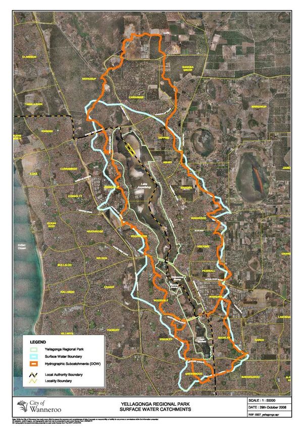
CONTENTS

CONTENTS                                                                                                                          3
ABBREVIATIONS                                                                                                                     4
EXECUTIVE SUMMARY                                                                                                                 5
1.0           INTRODUCTION                                                                                                        7
      1.1     YELLAGONGA REGIONAL PARK ................................................................... 7
      1.3     BACKGROUND .............................................................................................. 11
      1.4     YELLAGONGA INTEGRATED CATCHMENT MANAGEMENT PLAN 2014-
              2019 ............................................................................................................... 13
      1.5     STRATEGIC CONTEXT ................................................................................. 14
2.0           YELLAGONGA CATCHMENT AREA                                                                                          15
      2.1     INTRODUCTION ............................................................................................ 15
      2.3     HYDROLOGY ................................................................................................ 15
      2.4     WATER QUALITY .......................................................................................... 19
      2.5     BIODIVERSITY .............................................................................................. 24
      2.6     THREATENING PROCESSES ....................................................................... 26
3.0           IMPLEMENTATION PLAN                                                                                                33
      3.1     KEY FOCUS AREAS ...................................................................................... 33
      3.2     YICM PLAN 2014-2019 PROJECTS .............................................................. 34
      3.3     REPORTING AND REVIEW ........................................................................... 35
4.0           PROJECT DETAILS                                                                                                    36
      4.1     JOINT PROJECTS ......................................................................................... 36
      4.2     INDIVIDUAL PROJECTS ............................................................................... 47
      Appendix 1 – Key Achievements of YICM Plan 2014-2019 ...................................... 61
      Appendix 2- Strategic Context .................................................................................. 65
5.0           REFERENCES                                                                                                         70

                                                                                                                                   3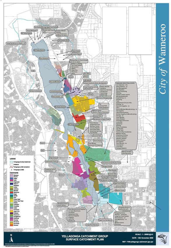
ABBREVIATIONS

ANZECC   Australian and New Zealand Environment Conservation Council

ASS      Acid Sulphate Soils

CCW      Conservation Category Wetlands

CoJ      City of Joondalup

CoW      City of Wanneroo

DEC      Department of Environment and Conservation

DER      Department of Environment Regulation

DoW      Department of Water

DPaW     Department of Parks and Wildlife

DPS2     District Planning Scheme No. 2

ECU      Edith Cowan University

EWR      Ecological Water Requirements

EWSP     East Wanneroo Structure Plan

LBS      Local Biodiversity Strategy

LEP      Local Environment Plan

LPP      Local Planning Policy

MRS      Metropolitan Region Scheme

NCCARF   National Climate Change Adaptation Research Facility

WAPC     Western Australian Planning Commission

WCP      Water Conservation Plan

YICM     Yellagonga Integrated Catchment Management

YRPM     Yellagonga Regional Park Management

                                                                       4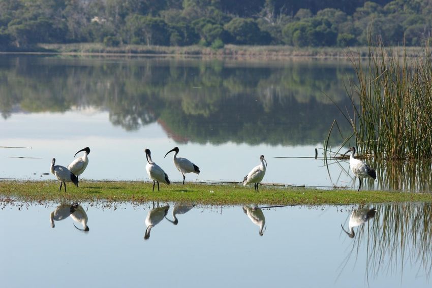
EXECUTIVE SUMMARY

Yellagonga Regional Park is one of eight regional parks within the Perth Metropolitan area
and lies on the Swan Coastal Plain located approximately 20km north of Perth. Yellagonga
Regional Park consists of a wetland chain including, from north to south, Lake Joondalup,
Beenyup Swamp, Walluburnup Swamp and Lake Goollelal.1

The Yellagonga Regional Park (the Park) is jointly managed by the Department of Parks and
Wildlife, and the Cities of Joondalup and Wanneroo (the boundary of which passes through
these wetlands). Land tenure is also vested in the Conservation Commission of Western
Australia and the Western Australian Planning Commission.

The Park’s co-managers, the Cities of Joondalup and Wanneroo and the Department of
Parks and Wildlife (DPaW) recognise that land use practices in the surrounding catchment,
from both past and present activities, can have detrimental effects on the wetlands of the
Yellagonga Regional Park and that it is the shared responsibility of the Park co-managers to
address the threats impacting the health of the Yellagonga Catchment Area. Impacts include
water quality and quantity entering the wetlands and threats to the ecological integrity and
biodiversity of the Park.

In order to maintain and enhance the amenity, recreational, educational, scientific, and
conservation values of Yellagonga Regional Park, for present and future generations, the
Yellagonga Integrated Catchment Management Plan 2009-2014 (YICM Plan) was developed
to provide a comprehensive and integrated approach to managing the Park. The Plan was
developed following extensive consultation with and guidance from a Community Reference
Group and Technical Working Group.

Part 1 of the YICM Plan document detailed the research and information collected during the
development of the Plan and provided an assessment of both the Park and Catchment Area.
Part 2 of the Plan was developed as an Implementation Plan with projects to be delivered
within the Catchment to mitigate the key threatening processes and issues identified
affecting Yellagonga Regional Park.

Following implementation of the Plan a detailed review of the Yellagonga Integrated
Catchment Management Plan 2009-2014 was undertaken in April 2014 whereby progress
made in delivering projects within the Plan was assessed. Following this review the Cities of
Joondalup and Wanneroo commenced development of the Yellagonga Integrated
Catchment Management Plan 2014–2019.

This Yellagonga Integrated Catchment Management Plan (YICM Plan) 2014–2019 provides
a holistic and strategic direction for the two Cities to continue to implement a wide range of
initiatives aimed to conserve the ecological values of the Yellagonga Regional Park.

Extensive historical and technical information regarding the Yellagonga Catchment Area is
contained within the YICM Plan 2009-2014 Part 1 Technical Report. This new YICM Plan

1
    CALM et al (2003)

                                                                                            5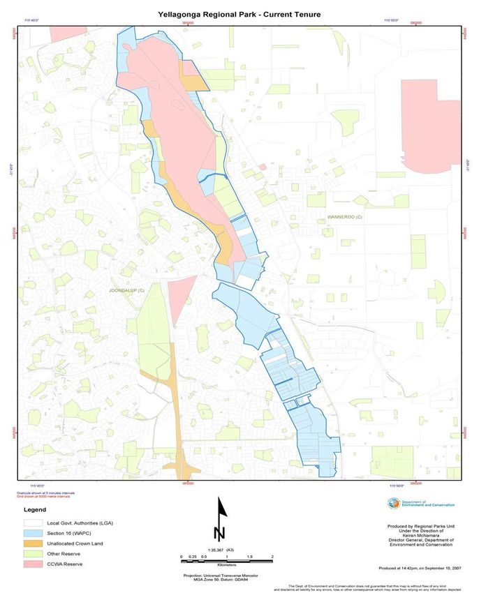
2014-2019 builds on the previous YICM Plan 2009-2014 with a focus on the implementation
process with new and ongoing projects being identified that will be implemented over the life
of the Plan.
A range of threats to the long-term viability of Yellagonga Regional Park remain, including
the drying climate trend, poor water quality, invasive flora and fauna species, wildfires,
disease spread, urban encroachment, remaining traditional stormwater drainage, habitat
degradation and fragmentation.
Significant progress has been achieved over the past five years to address the key threats to
the Park. Key achievements include:
Regular water quality monitoring and collation of water quality data.
The delivery of wide ranging community education and ecotourism initiatives.
Coordinated pest animal control and conservation maintenance schedules.
Further policy and plan development to direct management actions within the
Yellagonga Catchment such as the City of Joondalup’s City Water Plan and the City
of Wanneroo’s Local Planning Policy 4.4: Urban Water Management.
However in order to provide ongoing, conservation gains across the Yellagonga Catchment
Area further long term management strategies are required as well as commitment and
collaboration from the two Cities and the Department of Parks and Wildlife. The Yellagonga
Integrated Catchment Management Plan 2009-2014 provides the Park’s co-managers with
detailed direction required to manage the Catchment Area in a sustainable manner to ensure
the long term protection of the Park for future generations.
The YICM Plan 2014-2019 will be implemented by the Cities of Joondalup and Wanneroo
with significant input and liaison with the DPaW.
6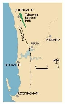
1.0           INTRODUCTION

1.1       YELLAGONGA REGIONAL PARK
Yellagonga Regional Park (henceforth referred to as “the Park”) is one of eight Regional
Parks within the Perth Metropolitan area and lies on the Swan Coastal Plain located
approximately 20km north of Perth.

There are a diversity of interests associated with the Yellagonga Catchment and Regional
Park – from residential landowners to those with commercial enterprises and those who use
this area for personal recreation, aesthetic enjoyment, historical and cultural heritage – both
Aboriginal and European, and those who appreciate the Park for its intrinsic environmental
values.

In order to maintain and enhance amenity, recreational, scientific, educational and
conservation values of the Park for present and future generations, an integrated catchment
approach has been undertaken to provide a comprehensive and integrated approach to
managing the Park.

1.1.2     Yellagonga Catchment Area
All water bodies, whether a wetland, lake or river, receive water from the surrounding area.
This area from which water flows into the water body is known as the catchment. Effective
management of a water body requires management of the surrounding catchment.
Integrated catchment management is about balancing use of the land, water and biological
resources within a catchment, in a sustainable manner, by encouraging co-operation and co-
ordination at all levels of government, in collaboration with the whole community on
management of these resources.2

By taking an integrated catchment management approach, the Cities of Joondalup and
Wanneroo and the DPaW recognise that activities outside of the Park and its wetland area
will impact on the ecological integrity and biodiversity of the Park, particularly through the
movement of groundwater, surface water and stormwater. Any land use within the catchment
will impact to some extent on the quality and quantity of water entering the Park’s wetlands,
as well as impacting on floristic and faunal communities within the Park. The catchment has
a diverse range of land uses comprised of residential developments, market gardens, aged
care, grassland, orchards, poultry farms, horse agistment, pine tree lots, plant nurseries and
various commercial developments (car yards, service stations, shopping centres etc), all of
which can impact on the Park.

The Park consists of a wetland chain including, from north to south, Lake Joondalup,
Beenyup Swamp, Walluburnup Swamp and Lake Goollelal.3

2
    Bunny and Mouritz (1995)
3
    CALM et al (2003)

                                                                                             7
4
Figure 1 Location of the Yellagonga Regional Park
The health of the Park and its wetlands is of high importance to both the local and wider
communities as well as the stakeholders and organisations responsible for the management
of the Park. The Park is identified as having significant regional value, particularly for:
Providing habitat for flora and fauna including iconic local species such as the Long-
necked Turtle, Carnaby’s Black-Cockatoo and Graceful Sun-moth;
Improving ecological function such as air quality, carbon capture, and soil health;
Decreasing erosion, salinity, water pollution and noise pollution; and
Providing opportunity for recreational and cultural experiences.
In order to maintain and enhance amenity, recreational, scientific, educational and
conservation values of the Park for present and future generations, an integrated catchment
approach has been undertaken to provide a comprehensive and integrated approach to
managing the Park.
4
CALM et al (2003)
81.1.3 Tenure and Management Arrangements
The Yellagonga Regional Park is composed of land that is owned or managed by a number
of different bodies including the Department of Parks and Wildlife (DPaW), City of
Joondalup, City of Wanneroo, Conservation Commission of Western Australia and the
Western Australian Planning Commission. There is also a small portion of land that remains
privately owned with individual landholders responsible for the management of their own
property.5
The DPaW is responsible for managing areas of the Park vested in the Conservation
Commission of Western Australia and for the overall coordination of the Park’s management
in accordance with the Yellagonga Regional Park Management (YRPM) Plan 2003-2013.
The Cities of Joondalup and Wanneroo manage areas of the Park that are vested in them in
accordance with the Management Zones outlined within the YRPM Plan 2003-2013.
While the land tenure for the Park is varied (see Figure 2), the integrated management of the
Park is shared by the DPaW and the Cities of Joondalup and Wanneroo. The co-
management of the Park is guided by the YRPM Plan 2003-2013. Additionally a
Memorandum of Understanding between the City of Joondalup and City of Wanneroo was
developed under the YICM Plan 2009-2014 which outlines the key responsibilities for the
two Cities in regard to the implementation of integrated catchment management activities.
In addition, there are a number of community groups, including conservation groups who
have input into the management of the Park.
5
CALM et al (2003)
9Figure 2 Land Tenure in Yellagonga Regional Park
101.3 BACKGROUND
This current Yellagonga Integrated Catchment Management (YICM) Plan 2014-2019 has
been developed within the context of the previous YICM Plan 2009-2014 and the Yellagonga
Regional Park Management (YRPM) Plan 2003-2013. The sections below provide
background information on these previous plans and how they relate to the current YICM
Plan 2014-2019.
1.3.1 Yellagonga Regional Park Management Plan 2003-2013
The YRPM Plan 2003-2013 was developed by the then Department of Conservation and
Land Management (now DPaW) and the Cities of Joondalup and Wanneroo, “to provide
broad direction for the protection and enhancement of the conservation, recreation and
landscape values of Yellagonga Regional Park”. One of the ‘High Priority’ strategies
proposed in the Management Plan was the preparation of an integrated catchment
management plan which was to be consistent with the overall direction of the YRPM Plan
2003-2013.6
The YICM Plan 2014-2019 addresses the activities being undertaken within the catchment
that affect the Park, while management of the Park itself is guided by the YRPM Plan 2003-
2013.
The YRPM Plan 2003-2013 is still considered current in its content and management
strategies and therefore is still being utilised to guide the management of the Yellagonga
Regional Park.
1.3.1 Yellagonga Integrated Catchment Management Plan 2009-2014
The development of the YICM Plan 2009-2014 and associated catchment management
projects was initiated through a Partnership Agreement between the Cities of Joondalup and
Wanneroo, who jointly funded the project, and involved considerable input from the
community and key stakeholders. This included two community workshops and the
establishment and involvement of a Community Reference Group and a Technical Working
Group. Key stakeholders included Friends of Yellagonga, Edith Cowan University, the then
Department of Environment and Conservation (now DPaW) and the Department of Water
(DoW).
Key outcomes from the community consultation process that informed the development of
the YICM Plan 2009-2014 were the identification of key threats (see Figure 3) and the
development of a community vision (see Figure 4). Further details of the community
consultation process and outcomes can be found in the YICM Plan 2009-2014.
6
CALM et al (2003), pp.1-2
11KEY THREATS TO YELLAGONGA REGIONAL PARK IDENTIFIED IN THE YICM PLAN 2009-2014
1. Contaminants
2. Inappropriate infrastructure
3. Urbanisation (development and planning)
4. Climate change and hydrology
5. Weeds
6. Impacts of introduced animals and pests
7. Lack of community education and awareness
8. Incidences of vandalism and rubbish dumping
9. Habitat destruction and fragmentation
10. Lack of understanding of fauna populations
11. Disease
Figure 3 Key threats identified in the YICM Plan 2009-2014
VISION STATEMENT
That activities in the catchment will support and give rise to:
“the conservation and rehabilitation of an endemically bio-diverse, quality, and sustainably
managed Regional Park with the necessary infrastructure for the enjoyment and education of
the whole community.”
Figure 4 Vision Statement developed for the YICM Plan 2009-2014 by the Community Reference Group
The YICM Plan 2009-14 comprised two parts. Part 1 provided a technical report on the
research and information collected during the two-year planning process and provided an
assessment of the health of the Park and the Catchment Area. Part 2 provided an
Implementation Plan and included 18 projects to be implemented within the Catchment over
the life of the Plan to mitigate the key threatening processes and issues identified within the
Yellagonga Regional Park.
With the implementation of the YICM Plan 2009-2014 scheduled for completion at the end of
the 2013-2014 financial year, a review of the Plan and its implementation has been
undertaken. This review has measured progress towards the completion of projects,
identified key achievements and has guided the development of the YICM Plan 2014-2019.
Substantial progress has been made in implementing projects within the YICM Plan 2009-
2014. Full details of the progress of projects are provided in Appendix 1.
121.4 YELLAGONGA INTEGRATED CATCHMENT MANAGEMENT PLAN 2014-
2019
Following the implementation and review of the YICM Plan 2009-2014 a new Plan to guide
management of the Yellagonga Catchment has been developed. The YICM Plan 2014-2019
builds on the progress made during implementation of the previous Plan and provides further
management recommendations to ensure the long term protection of the Yellagonga
Regional Park with a focus on addressing the current and future impacts of climate change.
1.4.1 Aim and Objectives of the Plan
The aim of the YICM Plan 2014-2019 is to provide a holistic and long-term strategic
plan to improve catchment health and protect the diverse values of the Park.
The objectives of the YICM Plan 2014-2019 are:
Objective 1: To build upon the achievements, experiences and outcomes of the YICM Plan
2014-2019 and continue to implement an integrated and effective approach to
catchment management.
Objective 2: To work in partnership with key stakeholders to improve catchment
management and protect and enhance the ecological values of the
Yellagonga Regional Park.
Objective 3: Ensure positive environmental, social and economic outcomes for the
Yellagonga Regional Park and its wetlands.
Objective 4: Consider the long term protection of the Yellagonga Regional Park with a
focus on addressing the current and future impacts of climate change.
1.4.2 Scope of the Plan
The YICM Plan 2009-2014 aims to build upon the outcomes of the previous Plan to provide
a guide for continuing to implement an integrated catchment management approach for the
Yellagonga Catchment Area. As such the YICM Plan 2014-2019 will:
Continue to use the outcomes of the original community consultation process and
technical review of scientific literature to inform its implementation;
Provide a brief overview of the Yellagonga Catchment and its environmental
condition;
Outline key achievements from the implementation of the YICM Plan 2009-2014;
Identify new and ongoing projects that continue the integrated catchment
management approach; and
Provide opportunity for stakeholder and community input into the delivery of projects
within the YICM Plan 2014-2019.
Responsibility for implementation of the YICM Plan 2014-2019 lies primarily with the Cities of
Wanneroo and Joondalup. The DPaW is a key partner in the delivery of a number of projects
within the Plan that relate to the health of ecosystems within Yellagonga Regional Park. The
implementation of the Plan will be more effective if strong partnerships with other
government bodies including DPaW, educational institutions and the local community are
13maintained.
In 2013 the Yellagonga Catchment Working Group, comprised of representatives from the
Cities of Joondalup and Wanneroo and DPaW, was established to assist communications
and commitment in working collaboratively on the YICM Plan. The Yellagonga Catchment
Working Group focuses on key projects requiring collaboration from the three managing
agencies.
1.4.3 Structure of the Plan
The YICM Plan 2014-2019 is comprised of four sections.
Section 1 Introduction - provides an introduction to the Plan including aim and objectives,
background to the Plan’s development, scope and strategic context to the Plan.
Section 2 Yellagonga Catchment Area - provides an overview of the Yellagonga Catchment
and its hydrology, water quality, biodiversity and threatening processes. However it does not
replace the extensive literature review contained within the YICM Plan 2009-2014.
Section 3 Implementation Plan – outlines five Key Focus Areas of the Plan, identifies issues
and objectives and details a project-based implementation framework with specific
catchment management projects to be implemented over the life of the Plan to achieve the
stated objectives. These include joint projects, delivered in partnership by the Cities of
Joondalup and Wanneroo, and individual projects that are implemented by either the City of
Joondalup or the City of Wanneroo.
Section 4 Project Details – details each of the projects identified in Section 3 including
project description, scope and approach.
1.5 STRATEGIC CONTEXT
The management of the Yellagonga wetlands catchment and the implementation of the
YICM Plan 2014-2019 needs to consider the strategic context in which it operates including
international legislation, Federal policy and legislation, State policy and legislation, regional
policy and local law and policy. Details of the relevant local, State and Federal plans and
strategies are provided in Appendix 2.
142.0 YELLAGONGA CATCHMENT AREA
2.1 INTRODUCTION
The Park catchment lies on the Swan Coastal Plain and is located approximately 20 km
north of central Perth. The surface water catchment area impacting on the Park is
estimated to cover an area of approximately 4000 hectares.7 The catchment is linked to the
Park by surface flows via drainage infrastructure and groundwater flows. The catchment
encompasses land on either side of the Park located in the Cities of Joondalup and
Wanneroo and includes medium to high-density residential, commercial and light industrial
development interspersed with green areas. Lakes Joondalup and Goollelal, and the
swamps Beenyup and Walluburnup, are the receiving aquatic environments for water from
this catchment via surface and groundwater flows.
Climate of the Swan Coastal Plain is described as being Mediterranean characterised by
long hot dry summers and a shorter period of wet winter months. The annual mean
maximum temperature is 24.4°C and the annual mean minimum temperature is 12.1°C. The
hottest months are January (average of 31.7°C) and February (average of 31.9°C). The
mean annual rainfall is 772.8mm with the wettest months being June (160.1mm) and July
(156.8mm).8
Soils and geology of the Perth metropolitan north-west corridor have been described by
McArthur and Bartle (1975-76). They describe the Park and catchment as lying over
quarternary deposits known as the Spearwood Dune System, which presents as a low hilly
and undulating landscape. The wetlands and surrounding catchment lies predominantly over
Spearwood sand with some areas of Karrakatta limestone and Karrakatta sand. The
Spearwood sands consist of some limestone outcrops with shallow brown soils and the
Karrakatta limestone is characterised by bare limestone or shallow siliceous or calcareous
sand over limestone. The Karrakatta sand is yellow and limestone usually lies beneath this
layer.9
A brief outline of the features of the Yellagonga Catchment and Regional Park are detailed
below. Full details of the key components of the Yellagonga Catchment can be found in the
YICM Plan 2009-2014 Part 1 Technical Report.
2.3 HYDROLOGY
2.3.1 Groundwater flow and levels
Groundwater flows from northeast to southwest across the Swan Coastal Plain towards the
Indian Ocean.10 Inputs into the groundwater from land uses many kilometres to the east
could eventually see impacts on the Park’s wetlands. While a groundwater catchment
boundary has not been developed, strategies can still be developed to address potential
land use impacts on groundwater - particularly given the high groundwater recharge rates
7
Ove Arup and Partners (1994)
8
Bureau of Meteorology (2014)
9
McArthur and Bartle (1975-76)
10
Department of Environment (2004)
15found on the Gnangara Mound. The highest recharge rates occur over the Gnangara
Mound, and range from 15-20 percent, reaching as high as 40 percent of rainfall as total net
recharge,11 which highlights the rapidity that any contaminants from landuse over the
Gnangara Mound may leach to groundwater.
Steep groundwater gradients occur to the east and west of the lake system and are
steepest on the west side of the wetland system, becoming shallow heading west
towards the ocean.12 Given the relatively slow rate of groundwater flow, residence time of
groundwater has implications for pollutant concentrations held within the lake systems.
2.3.2 Surface Water
Wetlands on the Swan Coastal Plain are generally surface expressions of an unconfined
aquifer with water levels reflecting the rising and falling groundwater levels.13 In the past,
Lakes Joondalup and Goollelal have fluctuated and followed natural cycles of drying and
filling, displaying patterns of long-term seasonal fluctuations according to climatic
conditions.14 However in more recent times, Hamann (1992) suggests the wetlands are not
exact surface expressions of the Gnangara groundwater system due to seasonal
fluctuations in wetland depth that does not match seasonal changes in the groundwater
table. The research has suggested that since urbanisation post 1975, an increasing
volume of surface water has entered the wetlands via impervious and cleared surfaces,
resulting in deeper lake systems. The drying climate trend however, indicates that there will
be reduced surface water expression from groundwater and rainfall. Figure 5 provides an
indicative surface water catchment boundary and the three Department of Water
hydrographic subcatchments for Yellagonga Regional Park.
11
Department of Water (2008a)
12
Congdon (1979)
13
Allen (1976)
14
Hamann (1992)
16Figure 5 Indicative Surface Water Catchment Boundary
17Surface flow through the Park’s wetlands moves from south to north, but, as this habitat is
now separated by roads dividing it into three sections; culverts and tunnels have been
constructed to enable the surface water flow to mimic the natural hydrological regime.
Water drains from Lake Goollelal into Walluburnup Swamp via a culvert under Hocking
Road and Whitfords Avenue and flows north into Beenyup Swamp. Ocean Reef Road
bisects Lake Joondalup into north and south sections. Flow between the two sections
only occurs during the winter months via a culvert. There is no surface outflow from this
wetland chain but outflow occurs via groundwater in an east to west direction.15
2.3.3 Drainage
In a natural system, rainfall would infiltrate directly to groundwater with limited overland flow
to wetlands. However, urbanisation has resulted in constructed roads and other impervious
surfaces, with traditional piped drainage networks and altered topography causing a
significant alteration to the natural hydrological regime. For the Park’s wetlands,
urbanisation has resulted in increased surface water run-off through drainage networks,
bringing with it polluted water.16
In the current climate of diminished rainfall, increased evaporation and a reduction in
recharge to groundwater, impervious surface contributions can be viewed as vital arterial
flows for many wetlands, however the wetland ecology would require uncontaminated water
entering the lakes.
2.3.4 Stormwater Drains
Stormwater drains are known to contribute significant nutrient loads into wetlands. There
are 36 drainage outfalls into the Park, including piped outfalls, swales, sumps, and
constructed wetlands. The City of Wanneroo ( CoW) manages 22 drains, and the Cit y of
Joondalup ( CoJ) manages 14. Main Roads Western Australia also manages drains and
sumps along Wanneroo Road. Several of these drains feed directly into City of Wanneroo
drains, which eventually lead to the Park’s wetlands.
The City of Joondalup upgraded all outfalls within the City’s boundaries that discharged
directly into the Yellagonga Wetlands prior to the previous YICM Plan 2009-2014. This
involved redirecting outfalls away from the wetlands with filtering systems. Although the
remaining stormwater catchment points are sumps that do not discharge directly into the
Park’s wetlands, the City has identified the upgrade of these sumps in the Stormwater
Drainage Program – Sump Beautification Program to consider for best environmental
outcome.
Wangara Sump has been identified as the highest priority for upgrade amongst all
stormwater infrastructure on the eastern side of Yellagonga Regional Park. The upgrade of
the Wangara Sump is being split into 2 stages, with stage 1 having been constructed and
stage 2 currently in the design phase as of the time of writing this reviewed Plan.
The City of Wanneroo commenced the retrofitting of stormwater infrastructure in 2009,
beginning with the Wangara Industrial Area. Further upgrades to the stormwater
15
Ove Arup and Partners (1994)
16
Kobryn (2001)
18infrastructure are scheduled to commence over the next few years within the surface water
catchment of the Yellagonga wetlands.
2.4 WATER QUALITY
2.4.1 Pollutants
Contaminants such as heavy metals, surfactants, hydrocarbons, nutrients, suspended
solids, litter and pesticides are common substances in urban wetlands.17,18,19 Pollutants and
contaminants enter the Park’s wetlands via stormwater run-off, groundwater flow and, to
a lesser extent, rainfall.
Key water quality issues arising from pollutants that can impact on the Park’s wetlands
include:
• Nutrient enrichment resulting in eutrophication, algal blooms and midge
outbreaks.
• Pollutants from toxicants (heavy metals, petroleum products, pesticides and
herbicides, industrial and household chemicals) can cause compromised immune
systems for wetland fauna, mutations, hormone disruption, reproductive
interference, poisoning, injury, and death.
• Pollutants bound to sediments can be re-released in water leading to the
mobility of these contaminants throughout food chains with unknown effects of
bio-accumulation on wetland fauna. For example heavy metals are mobilised
under acidic conditions.
• Sedimentation and suspended solids reduce light penetration leading to
restricted plant growth and smothering of flora and fauna.
• Litter is unsightly and can reduce light reaching some plants, with unknown
effects of dyes and chemicals from printed materials, and possible choking /
ingestion hazards for some wetland fauna such as freshwater turtles and avian
fauna.
The legacy issues of past land uses are considered to have an ongoing adverse impact on
the Park’s wetlands; these include market and commercial gardens, poultry industries and
septic tanks. See Figures 6 and 7.
17
Davis et al (1993)
18
Bunny and Mouritz (1995)
19
Whitely (2004)
19Figure 6 Past Land Uses to the East of Yellagonga Regional Park in 1979
20Figure 7 Past Land Uses to the East of Yellagonga Regional Park in 1990
21The Wangara Industrial Area is a current land use that may potentially have an adverse
impact on the water quality of the Park’s wetlands. Untreated stormwater has been draining
into a compensating basin on the boundary of Walluburnup Swamp. The stormwater
drainage infrastructure in this industrial area is in the process of being retrofitted in order to
filter and redirect stormwater away from the Yellagonga Wetlands. Other present land uses
include market gardens, septic tanks, diverse commercial uses, residential areas and the
high use major and minor roads, which surround the Park. Some drainage subcatchments
accommodate significantly more potentially polluting land uses than others as indicated in
Figure 8. Pollutants potentially arising from these land uses can also enter the Yellagonga
wetlands via groundwater movement.
22Figure 8 Drainage Sub-catchments in the Yellagonga Catchment Mapped 2008
232.4.2 Monitoring
Further research and monitoring programs of surface and groundwater quality have been
undertaken in the Park and in the surrounding catchment by the Edith Cowan University
Centre for Ecosystem Management for the YICM Plan 2009-2014 Water Quality Monitoring
Program and the Midge Steering Group Partnership research projects.
The monitoring and research have continued to indicate high concentrations of nutrients and
heavy metals in the surface and groundwater of the Yellagonga Wetlands that have
exceeded the Australian and New Zealand Environment Conservation Council (ANZECC)
guideline values (risk to environment). Groundwater has been identified as a major source
of nutrients and some metals into the Yellagonga Wetlands, particularly through Beenyup
Swamp.
The source of metals around a drain site north of Whitfords Avenue has been identified as
being from acid sulphate soils and also from Lake Goollelal where low water levels have
resulted in some acidification of the Lake’s sediments.
On the ground initiatives have commenced following recommendations from the Edith
Cowan University Centre for Ecosystem Management including a site specific acid sulphate
soils investigation. Other recommendations to improve water quality that are under
consideration include:
A vegetated bund in the southern section of Lake Joondalup.
Artificial water maintenance of Lake Goollelal.
The Yellagonga Water Quality Monitoring Program is proposed to continue in the YICM Plan
2014-2019 to provide consistent and comprehensive water quality data, analyses and
recommendations upon which sound management decisions can be made.
2.5 BIODIVERSITY
2.5.1 Flora
The vegetation communities within the Park have been identified as nine wetland communities
(consisting of sedgelands, woodlands, open and closed forests) and five dryland
communities (consisting of open and closed forest as well as woodlands). Much of the
remnant vegetation has been altered with only a small area identified as in pristine
condition in the northern-most section of the Park found in the Melaleuca rhaphiophylla /
Eucalyptus rudis closed forest community. Weeds remain a key threat in the Park.20
Three types of emergent vegetation exist within the park – Baumea articulata,
Schoenoplectus validus and the introduced giant reed Typha orientalis which is a key threat
to native rush communities – particularly in Lake Joondalup and Walluburnup Swamp.21
Fringing vegetation around the wetlands is fragmented, with some decline in Eucalyptus
rudis and Melaleuca rhaphiophylla observed at Lake Goollelal as well as Lake
20
Regeneration Technology (2002)
21
CALM et al (2003)
24Joondalup22. Weed invasion is also evident in the understorey, such as the highly invasive
introduced grasses Kikuyu (Pennisetum clandestinum), Buffalo (Stenotaphrum secundatum)
and Couch (Cynodon dactylon).23
A high proportion of the dryland vegetation that once surrounded the Park has been cleared
in order to support past and existing land uses such as agriculture and residential
development. Tuart-Jarrah-Marri (Eucalytus gomphocephala - Eucalyptus marginata -
Corymbia calophylla) open forest exists as a patchy distribution in the west with some
open forest to the north east of Lake Joondalup, with scattered Tuarts to the east of
Walluburnup and Beenyup Swamps and northeast of Lake Goollelal. Banksia, Jarrah and
Marri exists in an open forest along much of the southeastern shore of Lake Joondalup
with large areas cleared for recreational landscape along the eastern shores of Walluburnup
and Beenyup Swamps and Lake Goollelal.24
2.5.2 Fauna
A formal register of fauna in the Park does not currently exist, however, it is known that
within the surface water catchment boundary, at least seven sites with threatened fauna
have been identified and many others further east of the boundary have been listed by the
DPaW. Two sites have been identified with threatened fauna within the Park.
Three snake species have been sighted in the Park - Tiger snake (Notechis scutatus), Carpet
python (Morelia spilota) and Dugite (Pseudonaja affinis).25 Five lizard species have also
been identified in the Park (Bamford and Bamford, 1990); the Australian Scincid lizard
(Ctenotus fallens), Striped skink (Ctenotus leseurii), Yellow- bellied skink (Hemiergis peroni)
and Lerista praepedita, as well as the Bobtail lizard (Tiliqua rugosa).
The Oblong turtle (Chelodina oblonga) exists within the lake systems. In temperate
wetlands, freshwater turtles are top end predators and their overall health and
presence is important in wetland ecology. Six frog species previously occurred in the
Yellagonga Park,26 including the Sandplain froglet (Crinia insignifera), Glauert’s froglet
(Crinia glauertii), Moaning frog (Helioporous eyrei), Western banjo frog (Limnodynastes
dorsalis), Slender tree frog (Litoria adelaidensis) and the Western bell frog (Litoria moorei).23
Mammals that have been sighted in the Park include the Western Grey Kangaroo (Macropus
fuliginosus), the Western Brush Wallaby (Macropus Irma), Southern Brown Bandicoot or
Quenda (Isoodon obesulus fusciventer), Brush-tailed Possum (Trichosurus vulpecula),
Echidna (Tachyglossus aculeatus) and Rakali or native Water-rat (Hydromys chrysogaster).
Foxes, rabbits and feral cats are pest mammals present in the Park and are discussed in
2.6.9 Introduced Animals.23
Four fish species have previously been observed in the Yellagonga lake systems – two
native and two exotic species. These include the native Swan River Goby
(Pseudoglobius olorum)27 and the Pygmy Perch (Edelia vittata).28 The exotic fish being
22
Department of Water (2008b)
23
CALM et al (2003)
24
Regeneration Technology (2002)
25
Australian Government (2014)
26
Bamford and Bamford (1990)
27
Bamford and Bamford (1990)
25Gambusia affinis27 and the European Carp (Cyprinus carpio).29
The Park is important as a summer refuge and breeding habitat for many resident
and trans-equatorial migratory water bird species.29,30 O v e r 1 2 0 a v i a n s p e c i e s h a v e
b e e n r e c o r d e d i n t h e P a r k . 2 9 Bekle (1997) identified at least 37 water bird
species during 1991-1993 (from the families: Anatidae, Podicipedidae, Anhingidae,
Phalacrocoracidae, Pelecanidae, Ardeidae, Plataleidae, Rallidae, Scolopacidae,
Recurvirostridae and Charadriidae). Combined results of surveys suggest there may be a
decline in water bird species utilising the Park’s wetlands. In addition to the water bird
species found in the Park, there were 47 species of terrestrial birds identified in the park by
Bamford and Bamford (1990).
Kinnear and Garnett (1997a) identified 121 macro-invertebrate taxa excluding the
segmented worms (Annelida). The dominant groups were the ten-legged animals (from the
order Decapoda such as shrimps and the small crustaceans) and true flies (from the order
Diptera such as midges). Considerable variability was found in distributions of macro-
invertebrates throughout the wetlands, both spatially and temporally, but the greatest
diversity and abundances of macro-invertebrates were typically found at South Lake
Joondalup and Beenyup Swamp.
2.6 THREATENING PROCESSES
2.6.1 Climate Change
Current Climate Change
The climate of south-west Western Australia has been undergoing significant change in
recent decades. These changes include increased temperatures, increase in sea levels,
decrease in rainfall, more intense storm events and increased storm surge.
The long term trend in WA’s average temperature has been steadily increasing since the
1950’s. Overall, temperature has risen approximately 0.8°C in this time (Climate
Commission, 2011). Temperatures appear to be experiencing greater extremes in recent
years. The mean number of days over 35°C between 1944–2014, was 27.5, however
between 1981–2010 it was 28.5 and in 2012 there were 41.31
The south-west of WA has had a 15% reduction in rainfall since the mid-1970s. This is a
result of fewer winter low pressure systems, more prevalent high pressure systems and,
since 2000, a decrease in the rainfall associated with each system.32
These changes have already impacted on the Yellagonga catchment and as a result
management responses will have to adapt accordingly.
Future Climate Change
Climate change is expected to continue into the future (see Table 1). While the extent of
change is dependent on both the amount of greenhouse gases that continue to be emitted
28
WAWA (1995)
29
CALM et al (2003)
30
Bekle (2007)
31
Bureau of Meteorology (2014)
32
IOCI (2010)
26and how the environment responds to changing temperatures it can generally be expected
that:
In 2070 the Yellagonga catchment will have hotter, drier and windier summers with the
number of days over 35°C nearly doubling. Winters will be drier, warmer and less windy as a
result of fewer low pressure systems.33
YELLAGONGA CATCHMENT CLIMATE IN 207034
2.7°C TEMPERATURE
EXTREME HEAT DAYS from 28 to 54
19% RAINFALL
7% POTENTIAL EVAPORATION
WIND SPEED 8% IN SUMMER 14% IN WINTER
2.0% RELATIVE HUMIDITY
1.4% SOLAR RADATION
35
Table 1 Climate Change Scenario for the Yellagonga Catchment in 2070
Climate Change Impacts
Predicting the exact scale and nature of climate change at a local level and the resulting
impacts is challenging and will depend on the response of local climate systems and the
level of future greenhouse gas emissions. The Yellagonga wetlands are situated within the
south-west corner of Western Australia, a global biodiversity hotspot and an area particularly
vulnerable to climate change.
Expected climate change impacts for Yellagonga wetlands are summarized in Table 2
adapted from the 2011 Report Card on Climate Change and Western Australian Aquatic
Ecosystems developed through the National Climate Change Adaptation Research Facility.36
33
City of Joondalup (2014)
34
Climate Change projections for Perth in 2070 compared to 1990 under a high emissions scenario
(A1FI). The projections have been generated using data from 23 climate models and global warming
estimates from the IPCC Fourth Assessment Report 2007.
35
CSIRO (2007)
36
NCCARF (2011)
27Anticipated Physical and Chemical
Key Stressors Potential Ecological Consequences
Changes
Reduced rainfall Reduced water entering aquatic Overall reduction in biodiversity.
ecosystems via rain, surface runoff or
Reduced runoff groundwater inflow. Progressive change from aquatic to
terrestrial species and habitats.
Declining Less internal water movement.
groundwater Local shifts in species composition.
Increased average and maximum Sensitive species may be lost due to
Increased water temperatures. changes in water availability,
temperature temperature, and water quality.
Increased evapotranspiration due to Increase in temperature tolerant
Changes to higher temperatures. species, existing pests and exotic
seasonality warm-water species.
Changes in rates of chemical
processes and equilibria. Potential extinctions of endemic
species unable to cope with the rate of
Reduction in extent, depth and volume change, especially those with poor
of wetlands and waterways. dispersal mechanisms or in habitats
affected by human activity.
Permanent systems becoming more
seasonal and seasonal systems Plant productivity will be affected by
becoming episodic or disappearing. changes in temperature, water quality
and higher CO2 concentrations.
Altered water regime (e.g. delayed
onset of winter filling, premature drying, Potential increase in algal blooms,
extended dry spells, and unseasonal anoxia and fish kills. Potential increase
rainfall due to cyclonic activity). in midges and mosquitoes.
Changes to water quality due to Potential disruption of reproductive
changing quantity and quality of cycles of biota. Changes to seasonal
inflows. migration triggers. Depletion of seed
and egg banks.
Acidification through oxidation of acid
sulphate soils (due to reducing water Altered nutrient and carbon cycles.
levels) and associated release of
metals.
Increased fire risk (frequency and
intensity).
Table 2 Expected Climate Change Impacts and Potential Ecological Consequences for Yellagonga
Wetland (Adapted from NCCARF, 2011)
282.6.2 Declining Water Levels
Variability is seen in wetland water levels along the Swan Coastal Plain as part of natural
cycles of seasonal and annual water fluctuations. However, a drying climate and over
abstraction of groundwater from the Gnangara Mound has resulted in declining groundwater
levels. Landuse to the east of the Park includes intensive horticultural industries and, in
addition, many private bores exist to the east of the Park.
Declining water levels have been shown to alter vegetation compositions (diversity and
structure) as well as their biomass. Both native and exotic vegetation that are well adapted
to water level variability have been found to predominate, although there appears to be a
greater propensity for invasions of monospecific exotic vegetation under declining water
levels.37 Declining water levels can reduce the vegetated and lake habitat for the array of
wildlife that depends on it.
2.6.3 Water Contaminants
Contaminants impacting on the water quality of the Yellagonga Wetlands are a key
threatening process and addressed in 2.3 Hydrology and 2.4 Water Quality.
2.6.4 Weeds
Weeds are undesirable plants and may include exotic plants or native Australian plants
from the Eastern States38 and may also be known as environmental or declared weeds.
Given the highly altered landscape of the Yellagonga catchment, invasion of weeds from
the catchment into the Park is an ongoing problem. In addition, given the extent of weed
growth in the Park, propagation of weeds from within the Park also pose a threat to the
ecological integrity of the Park. Weeds produce structural and compositional changes to the
vegetation, degrade fauna habitat, and threaten persistence of fauna within the Park.
Weeds also invade disturbed habitat, dominating post-fire succession and, in turn, promote
susceptibility to fire re-occurrence.
2.6.5 Acid Sulphate Soils
Acid sulphate soils (ASS) are found naturally in the environment and are common around
coastal areas, although they do occur inland. Coastal ASS are the result of historic sea level
rises, in particular sea level rises during the Holocene (within the last 10,000 years),
where sulphate in the seawater mixed with land sediments containing iron-oxides and
organic matter forming extensive areas of iron sulfides. When these iron-sulfide rich soils
and sediments come into contact with air (for example, through dewatering, excavation,
lowered water table etc), the iron sulfides react with water and oxygen to form iron
compounds and sulfuric acid.39
37
Hudon (2004)
38
Keighery (2002)
39
DEC (n.d)
29In Western Australia, ASS typically occurs in water-logged conditions with soil types that
include peat, pale grey Bassendean / Spearwood sands, or coffee rock and also in dark
organic rich soils / muds. Soils of the Park and catchment are described as Potential Acid
Sulphate Soils, with soils around the Park predicted to be Class 1 ‘High Risk ASS’ occurring
within 3m of the soil surface.
Disturbance of ASS results in acidification of surface waters, groundwater aquifers and the
soil. Acidification enhances the mobility of metals,40 in particular, aluminium and arsenic,
which are highly toxic to wetland flora and fauna with potential impacts on human health.
Acidic conditions in surface and groundwater can cause damage to infrastructure such as
retaining walls, boardwalks, private dwellings as well as death of aquatic organisms in
acidified wetlands.
A site specific ASS investigation is being undertaken for the Cities of Joondalup and
Wanneroo, however more extensive ASS investigations are proposed in this YICM Plan
2014-2019 to make progress on groundtruthing of acid sulphate soils and develop
management strategies as required.
2.6.6 Dieback and Other Plant Pathogens
Dieback is a disease caused by the introduced soil-borne water mould Phytophthora
cinnamomi and destroys many Australian native plant species in forests, woodlands and
heathlands. Phytophthora is listed as a key threatening process to Australian biodiversity
under the Environment Protection and Biodiversity Conservation Act (1999).41 The pathogen
is spread mostly by human activity and by water movement, and at present, there is no
means to eradicate the pathogen. Control of Phytophthora is affected by limiting its spread,
utilising various methods that prevent the transfer of soil particles, for example washing /
scraping hiking boots, camping gear, vehicle tyres and using dedicated wash-bay facilities.
A number of plant species have been identified in the Park as being susceptible to
Phytophthora dieback including Jarrah (Eucalyptus marginata), Banksia sp. and Grass trees
(Xanthorrhoea sp.).
Pathogen management within the Park is to be monitored through the Local Biodiversity
Project proposed in this YICM Plan 2014-2019 which includes the City of Joondalup
Pathogen Management Plan.
2.6.7 Wildfires
Excessive wildfires commonly caused by arson can devastate the Park’s vegetation
particularly when the frequency of fires reduces adequate time for natural regeneration.
Fauna have nowhere to escape the effects of fire, with loss of life and habitat, increasing
their vulnerability to predation and decline. Past practices from Aboriginal burning may not
have produced marked changes to ecosystem composition around wetlands,42 however
today, weed invasion post-fire is an ongoing issue for the Park. Fire also affects soil, which
in turn may impact on water quality in wetlands.
40
Van der Welle et al (2007)
41
Vear and Dell (2004)
42
Bickford and Gell (2005)
30Fire management within the Park is to be monitored through the Local Biodiversity Project
proposed in this YICM Plan 2014-2019 which includes the City of Joondalup Fire
Management Plan. The City of Wanneroo currently manages bushfire through the City's
Fire Protection Officers who assess fuel loads in the City's reserves and write prescriptions
and undertake prescribed burns accordingly.
2.6.8 Habitat Destruction and Fragmentation
On the Swan Coastal Plain, much of the natural landscape has been cleared for urban
development with natural habitat, including wetlands, now existing as small islands in a sea
of urbanisation. The Park is separated by Ocean Reef Road and Whitfords Avenue and
exists as three areas of natural habitat. While the terrestrial buffer for the most part is
greater than 100m, much of this is highly altered with large areas dedicated to grassed
parkland. The provision of adequate terrestrial buffers of natural vegetation is vital for overall
health and functioning of wetland ecology.
The three separate areas of the Park are surrounded by roads and residential development
which has resulted in limited or no opportunities for terrestrial animals to disperse between
habitats, restricting contributions into the gene pool or ‘rescue’ for declining populations.43
Wide-ranging animals are those that are typically vulnerable as fragmentation often results in
smaller habitats that cannot provide for all their needs, and these animals are the ones
killed as they attempt to cross roads seeking alternative habitat.43
2.6.9 Introduced Animals
Occasional sightings of foxes are made in the vicinity of and within the Park along with
rabbits and wild cats. The European red fox (Vulpes vulpes) is a non-selective feeder and
survives well in a fragmented environment, and particularly well in t h e urban
environment.44 Cats also pose a significant threat to the fauna within the Yellagonga
Regional Park, whether they are classified as domestic, stray or wild/feral.
While the fox is a declared animal and must be controlled by the land-owner or a local
government under the Agriculture and Related Resources Protection Act 1976, they
need to be removed simultaneously with cats and rabbits. Although foxes and cats are
non-selective feeders, both prefer rabbits. Foxes appear to exert some predatory /
competitive control over wild cats and, if only foxes are removed, wild cats will slip into this
ecological niche.45 Further to their introduced status, the interconnectivity between all three
species drives the need for simultaneous control. A fox control program facilitated by DPaW
has been implemented in coordination with the two Cities and the Yellagonga Regional Park
Community Advisory Committee.
Unleashed dogs also negatively impact native fauna populations as they have the potential
to chase, disturb and harm wildlife within the Park.
Other introduced animals in the Park include the European honey bee (Apis mellifera), the
Silver Gull (Larus novaehollandiae), Pigeons (Family – Columbidae) and Geese (Family –
Anatidae). It is also likely that the Argentine Ant (Linepithema humile) is still present. The
43
Noss and Csuti (1997)
44
Saunders et al (1995)
45
Risbey (2000)
31European honey bee presence within the Park is predicted to have a detrimental impact on
native flora and fauna.46
The Regional Parks Pest and Problem Animal Control Plan (DEC, 2006) provides
recommendations for control methods for major pest and problem animals.
2.6.10 Vandalism and Rubbish Dumping
While the majority of people who recreate within the Park appreciate the environmental
and cultural values of the area, the issues of graffiti, dumping of rubbish and other forms of
vandalism occur throughout the Park. The DPaW and the two Cities manage graffiti and
rubbish removal on an ongoing basis.
Community initiatives such as interpretive signage, information brochures and tours have
been designed to raise community awareness of the conservation significance and value of
the Park and encourage the responsible use of the area.
46
CALM et al (2003)
323.0 IMPLEMENTATION PLAN
3.1 KEY FOCUS AREAS
Five Key Focus Areas have been developed to address the key issues in the Yellagonga
Catchment. The Key Focus Areas and key issues were developed based on the key threats
identified in the YICM Plan 2014-2019 and consideration of the achievements, improved
knowledge and outcomes as a result of implementing the YICM Plan 2009-2014. In addition,
objectives have been developed for each of the Key Focus Areas and are provided below.
KEY FOCUS KEY ISSUES OBJECTIVES
AREA
Water Quality Water contaminants Improve the water quality of the
Yellagonga Wetlands
Inappropriate stormwater
infrastructure Reduce opportunities for pollutants in
water to enter the Yellagonga Wetlands
Urban Planning Soil contamination Ensure that integrated catchment
and management is considered in the land use
Acid sulphate soils
Development planning decisions of both Cities
Inappropriate stormwater
Protect the Yellagonga Wetlands from the
infrastructure
impact of soil contamination
Reduce opportunities for pollutants to
enter the Yellagonga Wetlands
Water Quantity Climate change To ensure the availability of water for
environmental uses within the Yellagonga
Reduced water levels
Wetlands
Increasing water consumption
To encourage water conservation within
neighboring land uses and the community
Biodiversity Climate change To conserve and enhance the biodiversity
of the Yellagonga Regional Park to ensure
Risk of pathogens spreading
healthy habitats for wildlife
Invasive flora and fauna species
Reduce incidences of wildfires within
Increased incidence and intensity of Yellagonga Regional Park
wildfires
Reduce the incidence of weeds and pest
Habitat fragmentation and animal species in Yellagonga Regional
degradation Park
Lack of scientific data on flora and Avoid the spread of pathogens and
fauna species disease within Yellagonga Regional Park
Community and Level of community awareness of Improve the community’s awareness and
Partnerships the conservation needs of understanding of the Yellagonga
Yellagonga Regional Park Catchment
Incidences of rubbish dumping and Reduce negative uses of Yellagonga
vandalism Regional Park
Table 3 Key Focus Areas of the Plan and their Key Issues and Objectives
333.2 YICM PLAN 2014-2019 PROJECTS
In order to achieve the aim and objectives of the YICM Plan 2014-2019, projects have been
identified for each of the five Key Focus Areas. These projects will be implemented over the
life of the Plan and will be subject to annual monitoring and review. Some of the projects are
joint projects between the two Cities and others are individual projects. Each project has a
recommended priority based on the below schedule:
High priority – project commencement in 2014-2015.
Medium priority – project commencement in 2015-2016.
A summary list of the projects along with their relevant Key Focus Areas and priority for
implementation is provided in Table 4 to Table 6.
3.2.1 Joint Projects
PROJECT TITLE KEY FOCUS AREA PRIORITY
Water Quality Monitoring Water Quality High
Vegetated Bund Construction Water Quality High
Water Conservation Project Water Quantity High
Midge Steering Group Partnership Research Water Quality/ High
Biodiversity
Acid Sulphate Soils Management Water Quality/ High
Urban
Development
Local Biodiversity Project Biodiversity High
Strategic Partnerships Community and Medium
Partnerships
Table 4 Joint projects to be Undertaken in Partnership between the Cities of Joondalup and Wanneroo
34You can also read