3D Modeling of the Cadastre and the Spatial Representation of Property - ResearchGate
←
→
Page content transcription
If your browser does not render page correctly, please read the page content below
Chapter 33
3D Modeling of the Cadastre
and the Spatial Representation
of Property

Lin Li, Renzhong Guo, Shen Ying, Haizhong Zhu, Jindi Wu,
and Chencheng Liu

Abstract An emerging technology, three-dimensional (3D) cadastres as extensions
to the current parcel-based or two-dimensional (2D) cadastre, has been developed to
meet the management of 3D urban land use and 3D properties. This chapter provides
a brief review of the key issues of 3D cadastre and the spatial representation of owner-
ship. In order to understand the importance of legislation for developing modeling
technology for 3D property, the legislative context of ownership is addressed in
specific reference to China. In light of spatial rights of land-use space, a 3D spatial
model of property is presented in terms of polyhedra with four-layer structures. Being
compatible with the existing 2D cadastre, this 3D spatial data structure is suitable as
a hybrid cadastral system for 2D and 3D property and provides an available means to
spatially represent 3D property with integrity. By analyzing the heterogeneity of the
land space used for property, the ownership of condominiums with internal structure
is addressed and spatial representation of ownership is presented by instantiation in
a case study in China.

33.1 Introduction

A cadastre is generally regarded as a comprehensive land recording of the metes
and bounds of a country’s real property. According to the International Federation of
Surveyors (FIG), a cadastre is normally a parcel-based and up-to-date land informa-
tion system containing an official record of interests in land (i.e., rights, restrictions,
and responsibilities or RRRs). In this record, the ownership, extent, and value of
real property in a given area are explicitly and clearly registered and used for fiscal
purposes (e.g., taxation), legal purposes, and to assist in the management of land and

L. Li · S. Ying · H. Zhu (B) · J. Wu · C. Liu
School of Resource and Environmental Sciences, Wuhan University, Wuhan, China
e-mail: hhzhu@whu.edu.cn
R. Guo
Research Institute for Smart City, Shenzhen University, Shenzhen, China

© The Author(s) 2021                                                                   589
W. Shi et al. (eds.), Urban Informatics, The Urban Book Series,
https://doi.org/10.1007/978-981-15-8983-6_33

590 L. Li et al.
land use (e.g., for planning and other administrative purposes). Registration of RRRs
is the administrative core of cadastres and properties.
As ownership is defined as the lawful record of a property or a piece of land
assigned to the people who own the property, the spatial extent and geographical
location of the property are the critical elements for substantiating the ownership.
Traditionally, a piece of land defined as a land parcel (or simply, a parcel) is a plane
area with a clear boundary on the surface of the Earth. From the boundary on the
ground, a spatial “cone” can be formed geometrically from the Earth’s center to
the sky, and ownership implicates the lawful record of all things within the spatial
“cone.” In this sense, the rights to land within the “cone” (space on, below, and above
the ground) are hypothetically homogeneous and can be easily demarcated by the
plane’s extent. As such, a two-dimensional (2D) or parcel-based cadastre has so far
dominated the administration of cadastres and has been adopted by various legal
systems.
With the evolution of society and the economy, especially in urban areas, rapid
urbanization presents a challenge to densely populated cities with limited urban land
resources, and changes to land-use patterns in the form of urban sprawl have been
increasing in recent years (Foley et al. 2005; Turner et al. 2007; Guo et al. 2013;
Zulkifli et al. 2015; Li et al. 2016). Space on, below, and above the ground cannot be
used merely for a single purpose. A piece of land must be shared by various parties
for different contexts, and rights to it cannot be secured by its plane extent. The
rights bounded to the space below or above ground are no longer fully consistent
with that on the ground. Thus, the use of a land parcel in terms of cadastre inevitably
evolves into the more general use of land space, which leads to a shift of focus
from the surface of land parcels to the space above and below them in land use and
development.
The emerging, spatially heterogeneous rights to land parcels break the spatial
homogeneity of land rights within the cone, as long as required by the 2D parcel-
based cadastre. The traditional concept of the 2D cadastre is augmented by dividing
the utilization of land space vertically, in order to accommodate increased population
density and intensive socioeconomic activities in urban areas. Three-dimensional
(3D) cadastres have been developed to meet the management of 3D land-use space
and 3D property (Guo et al. 2013; Stoter et al. 2013; Jazayeri et al. 2014; Karabin
2014). This emerging technology helps meet the increasing social demand for the
precise management of immovable property (land and housing).
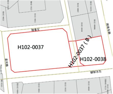
Here, a typical example quoted from the study by Guo et al. (2013) may present
an intuitive understanding of the deficiency of a parcel-based cadastre. They cite a
parcel with a complex building on it in Shenzhen, one of the fastest-growing and most
economically advanced cities in China. This complex is made up of several plaza
buildings containing many shops. Two main buildings are separated by a municipal
road and connected by an arched structure. The buildings are registered on a parcel-
based cadastral map (Fig. 33.1). The land space used for the over-ground arch is drawn
on this map and labeled with H102-0037(B), which overlaps with the commercial
shops and the underground parking lot. Two adjacent parcels, H102-0037 and H102-
0038, contain the two main buildings, respectively. However, H102-0037(B) refers to
the parcel above the surface, while H102-0037 and H102-0038 refer to parcels on the
surface. The land space of the arch, a public pedestrian corridor (a kind of easement),
belongs to the municipality, while the underground shops above the parking lot are
33 3D Modeling of the Cadastre and the Spatial Representation …                      591

Fig. 33.1 Cadastral map
(Guo et al. 2013)

Fig. 33.2 The vertical
profile of construction
(modified from Guo et al.
2013)

owned by different individuals. The vertical configuration is illustrated in Fig. 33.2.
However, it is found that this 2D cadastral map fails to record the spatial configuration
of land space and may even confuse readers. The implications of a multi-purpose
use of land in H102-0037(B) could not be geometrically clarified on the 2D cadastral
map without adding a third dimension.

33.2 Spatial Rights to Real Property

33.2.1 Legal Context of a 3D Cadastre

When real property or a cadastre is registered on a 2D cadastral map, spatial rights
to real property, or the spatial extents assigned by ownership, can only be directly
presented in terms of 2D geometry, even though the rights are legally attributed in
592                                                                           L. Li et al.

3D. As the above example shows, a 2D cadastre cannot represent the 3D features of
property. As the spatial rights are prescribed, interpreted, and implemented within
legal systems, it is important to understand the legal context in order to model the
spatial extent of the rights.
    Ownership of land, or property in a wider sense, is set by legal systems and social
conventions. The key issue in land administration is the management of various
property or spatial rights on, in, and attached to the piece of land. These rights are
embodied in the concept of property, which may have different meanings in different
countries (Kalantari et al. 2008; Stubkjær 2004) that are largely dependent on legal
systems (Paulsson and Paasch 2011). Some countries—such as the Netherlands,
Germany, the UK, France, and Belgium—define ownership as the rights to the ground
and of all space above and below it, including groundwater and fixtures (van der
Molen 2003). Other countries understand ownership in a way that does not include
mines and groundwater. Some jurisdictions may not allow separate rights to a parcel
from construction on it, such as in the Netherlands and China. Other nations, such as
Denmark, accept, through leasing, different ownerships for land and for buildings;
in fact, the formation of a property “on top of another property” can be implemented
under a special procedure (Sorensen 2011).
    As most systems of land administrations in the world are set on the basis of 2D
cadastres, the development of a 3D cadastre requires the amendment of property laws
and regulations when land use extends spatially to a vertical from a horizontal plane.
This is a big issue especially for those developed countries with comprehensive legal
and administrative systems. It usually takes a quite long and arduous effort to finish
an amendment. However, the laws in developing countries or regions are likely to
be amended more easily than those of developed countries due to their imperfect
legislation and administration.
    China is a rapidly developing country and is currently perfecting her legislation
and administration, which gives her room to adapt, update, or refine some items in her
property laws where spatial rights of property have not been defined in great detail. It
was in 2007 when the Real Right Law of the People’s Republic of China was issued
and took effect (October 1, 2007). The right to land is founded also on the principles
of the parcel-based cadastre; however, Article 136 in this law states that “the right to
use construction land may be created separately on the surface of or above or under
the land. The newly established right may not injure the usufructuary right that has
already been established.” Article 138 further states that land space occupied by
buildings, fixtures, and affiliated facilities shall be contained in a contract with the
transfer of rights.
    The separation of property rights for construction above and underground from
those on the surface implies that uses of above and underground spaces may be
different from those of the surface and that the parcel space may be multi-level,
across boundaries, or without 2D geometric limitation. It indicates that the rights to
land are always associated with some construction and no ownership will be created
without construction (or buildings). This law provides a good legal basis for local
governments to create their own rules and regulations for land use and makes it easier
to develop a 3D cadastral system than in more developed countries or regions.
33 3D Modeling of the Cadastre and the Spatial Representation …                     593

33.2.2 Geometry of 3D Property with Homogeneous Land
       Space

A property has both bona fide and legal aspects (Aien et al. 2013; Jazayeri et al.
2014; Ying et al. 2014), and it is considered a compound object that combines the
physical object with the legal treatment of the object. The physical object (such as
a usable unit of land space or an apartment) takes certain geometry and is the base
of the ownership and other rights. The legal aspect of property is attached to the
physical object and refers to or involves more space in various senses; for example,
solar rights to an apartment involve a space beyond the space occupied just by the
apartment and without a clearly defined boundary (Li et al. 2019). Thus, the spatial
representation of the physical objects is the major task of modeling 3D property that
is explicitly defined by spatial extent in the physical 3D space, that is, modeling
ownership by spatial means.
    As a building is always attached on a piece of land, a 3D property (containing
both land and building or construction) consists spatially of two 3D geometries: a 3D
model of the construction and a 3D container that is a derived spatial extent of land
space used by the construction. Since a 3D model of construction is included in the
container, the spatial relation of a property with others can be captured by the spatial
relation among the containers. The architectural configuration of the construction
may have some influence on rights to land space, such as the geometry of easement
on neighboring spaces, and will be shaped by the access points of the architecture.
However, this kind of influence is hardly depicted in an explicit geometry. Therefore,
in terms of the cadastre, spatial modeling of a property in the form of land space is
aimed at presenting an explicit 3D geometry of the containers, which simplifies the
geometry of a property into a polyhedron. It comprises a prism or a combination of
prisms that have vertical faces and flat tops or bottoms (Fig. 33.3).

Fig. 33.3 Geometry of 3D
property in a cadastre
594                                                                           L. Li et al.

    This simplicity results from the fact that land space for above or underground
construction is plotted depending on a planar parcel. The faces of a polyhedron and
the edges of the faces should satisfy the generalized Jordan curve theorem that refers
to the orientability of these geometric elements. The interior of the container is hypo-
thetically connected, which means that any container is simple, and no compound
or multiple containers are allowed. If a container can be divided into two or more
independent containers, each of the latter is treated as a simple one.

33.3 Integral Spatial Modeling of 3D Property

Spatial modeling of 3D objects long has been studied and is being addressed in the
domain of geographical information systems (GIS) and related fields. Many 3D data
models have been presented and are used to capture the spatial features of 3D objects
in terms of geometry. 3D objects may be featured by simplexes (point, line, triangle,
and tetrahedron; Carlson 1987), configured by a 3D formal data structure (FDS)
(Molenaar 1990), represented by tetrahedronized irregular networks (Penninga et al.
2006), by polyhedra (Arens et al. 2005; Stoter 2004; Wenninger 1974; Zlatanova
2000), by polyhedral regular polytopes (Thompson 2007), or by a constructive solid
geometry (CSG) and B-rep approach in computer graphics. Those data models have
been commonly used for different fields and applications with certain semantic foci.
    In spatially modeling of land administration and registration of property, an
emphasis is placed on keeping these data consistent when developing a real 3D
cadastre and extending its spatial dimension from 2D, since the semantics embedded
in the data models are used to regulate and coordinate relationships among people
and property under a given society, economy, and legal system. Therefore, the data
model of 3D property should be compatible with the existing data model in 2D
parcel-based cadastral systems so that the semantics recorded in the latter will not
change.
    The 2D data models with three-layer structure including topological features—
faces, edges, and nodes (vertices)—are commonly adopted in 2D cadastre. A simple
example is shown in Fig. 33.4 with Table 33.1, where an edge is terminated by its
two nodes and a face is represented by its surrounding boundary as a series of edges.
For example, in that figure f14 is composed of four edges {e25, e26, e27, and e28}.

Fig. 33.4 2D data model for parcel-based property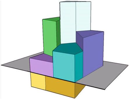
33 3D Modeling of the Cadastre and the Spatial Representation …                          595

Table 33.1 Table of the 2D data model shown in Fig. 33.4
Edge           From_Node            To_Node           Left_Face          Right_Face
…
e25            v15                  v16               f14                 f0
e26            v16                  v17               f14                 f0
e27            v17                  v18               f14                 f0
e28            v15                  v18               f13                f14
…

   Adding a 3D topological feature—a volume—to the 2D data model forms a 3D
data model with four-layer structure for the 3D cadastral system. Consequently, a
volume that is able to depict a container or polyhedron is represented by a set of faces
that enclose a 3D space. Such a 3D data model may be operationally structured with
a 3D piecewise linear complex (PLC), a commonly used geometric data structure
in computer graphics (Cohen-Steiner et al. 2004; Miller et al. 1996; Si and Gartner
2005).
   For example, two volumes (3D properties) in Fig. 33.5a are integrated with 2D
parcels into a 3D spatial configuration of 3D space that accommodates both 2D
properties and 3D properties shown in Fig. 33.5b. Volume Vol2 is represented by an

    (a)

©                                                ©

                  (b)

Fig. 33.5 A 3D data model of property compatible with a parcel-based 2D data model (modified
from Guo and Ying 2010). a Two volumes (containers) with 3D geometry. b Compatible data model
for 2D and 3D cadastre
596                                                                           L. Li et al.

enclosed face set {f7, f8, f9, f10, f11, f12}, and face f8 is demarcated by a set of
edges {e15, e16, e17, e18}. Volume Vol4 is regarded as a special kind of 3D object,
being degraded from 3D geometry into face f14 of the 2D geometry. This simple
example shows that the 3D data model matches well with the commonly used 2D
data model.

33.4 Heterogeneity of Land Space Used for Property

If an ownership includes a certain land space where all constructions lie within the
space, a container mentioned above in the form of a polyhedron can be spatially
modeled due to its homogeneous space with respect to ownership. However, in a
densely populated urban area, many high-rise buildings are created to provide more
housing and to accommodate more people. A unique owner of an apartment in a
building is not an exclusive owner of a parcel of land that is undividable. Although
an apartment uniquely occupies a chunk of land space and its ownership could be
also spatially modeled by its polyhedral container geometry, different legal treatments
associated with the ownership emerging from sharing integrity of land space break
the homogeneity of the land space used by the apartment. In this case, the internal
structure of the ownership should be clearly presented by its spatial representation.
This poses a critical requirement for more precise management of property that
includes not only land space and the vertical spatial extent of the property, but also
the horizontal extent of the property and the ownership structure, which corresponds
to the spatial components of the property.
    In general, a property being viewed as a compound object combines the physical
object with the legal treatment of the object in data models. However, a physical
object (building or apartment) may be constructed with several parts with different
functions or intentions, which lead to different legal treatments included in the owner-
ship. An internal heterogeneity is then emerging in the ownership and reflects the
disparity of the lawful recording of the different parts of an object and requires
differentiating ownership in a property management system. A condominium unit is
a typical property of this kind.
    With a common or shared ground parcel, a building consisting of condominiums
is divided into private and common parts. This co-ownership has been discussed by
many studies (Çağdaş 2013; Pouliot et al. 2011, 2013; Rajabifard et al. 2013; Li
et al. 2016). For this kind of ownership two types of ownership are found, exclusive
ownership and shared ownership. Exclusive ownership means that an owner can
dispose of his or her parts according to the corresponding laws. Shared (or common)
ownership means that the common parts and the ground parcel cannot be disposed
at someone’s own will and must be disposed in common. It is also found that an
ownership of a condominium is not the same as ownership of a piece of parcel
or a chunk of land space. Its different spatial parts with certain rights should be
represented in detail so that the internal structure of the ownership is expressed in a
spatially explicit manner targeted toward more precise management of property.
33 3D Modeling of the Cadastre and the Spatial Representation …                       597

   Physical structural components associated with a condominium unit may have
different rights to each part with internal homogeneity and those different rights
come together to constitute the ownership of the condominium. For example, in
China, an ownership of a condominium unit may include two physical objects: the
exclusively owned apartment itself and some space (such as elevators and corridors)
that is shared with others. The ownership includes at least two different internal
rights to the parts. Even for exclusively owned objects (or spaces), the room space
is physically recorded into the legal spatial extent, and a balcony (space) may be
half-recorded into the legal spatial extent. Such subdivisions of ownership with legal
space are critical in taxation, loans, and insurance.
   As parts of land space corresponding to certain physical objects, each of these
parts in general can be suitably modeled by an enclosed polyhedron in the four-layer
structure. However, it becomes critical to clarify the semantics of those parts with
ownership and spatial relations among them in spatial modeling of the ownership.
As mentioned above, the meaning of ownership varies with different legal systems
and social conventions; it would be much more helpful to discuss the spatial repre-
sentation of the condominium ownership with a given legislative and institutional
context. The following section uses China as an example.

33.5 A Case Study of Spatial Modeling of Ownership
     Structure in China

33.5.1 Ownership of Condominiums in China

According to the Land Administration Law in mainland China, urban land is admin-
istered differently from rural land. Any urban land is uniquely owned by the State
and ownership cannot be altered. Ownership of the buildings or other construc-
tions on urban land can be attributed to individuals or any legal parties. A property
embodies the ownership of a house, a building, or buildings and the usufruct of land.
In this legislative context as well as social conventions in China, condominiums are
the predominant form of housing property in urban areas. Ownership is legislatively
ensured by the Real Right Law of the People’s Republic of China (People’s Republic
of China 2007), which offers provisions for the owners’ co-ownership of building
areas. Its Article 70 states that “as regards such exclusive parts within the buildings as
the residential houses or the houses used for business purposes, an owner shall enjoy
the ownership thereof, while as regards the common parts other than the exclusive
parts, the owner shall have common ownership and the common management right
thereof.”
    Ownership of a condominium unit refers to two types of objects, that is, exclu-
sive objects and common or shared objects. In Specifications for Estate Surveying
(People’s Republic of China 2000), exclusive objects are further divided into
two types of objects: the major body and annexes such as balconies, basements,
598                                                                                  L. Li et al.

Table 33.2 Internal structure of ownership of a condominium unit
Physical parts   Physical objects     Sub-objects   Counted physical     Remarks
                                                    space
Exclusive        Major body                         Completely           Rooms
                 Annexes              De facto      Totally              Balconies in the
                                                                         major structure
                                      Ratio         Partially            Balconies outside of
                                                                         the major structure
                                      Fiat          Non (height <        Bay windows
                                                    2.1 m)
                                                    Partially (others)
Shared           Apportionable        De facto      Totally              Commonly owned
                                                                         indoor stairs
                                      Ratio         Partially            Commonly owned
                                                                         corridors
                                      Fiat          Non                  Commonly owned
                                                                         roof gardens
                 Non-apportionable                  Non                  Basements

and garages; common objects are further divided into apportionable and non-
apportionable objects. Construction area is used to measure ownership in terms of
magnitude. Apportionable means that the metric geometry of the objects is calcu-
lated in some approach to contribute the construction area of the corresponding
condominium units, and non-apportionable means that the objects make no contri-
bution to the construction area. That is, the legal construction area of a condominium
unit consists of the construction area from its exclusive parts and from its shares of
apportionable objects.
   Since the spatial extent of physical objects from both types is the metric base
for deriving the construction area and measures ownership in different ways, owner-
ship of a condominium unit is structured by different parts in light of the physical
configuration of the unit and buildings including the unit. The internal structure of
ownership is tabulated in Table 33.2.

33.5.2 Implementation Tool for Spatial Modeling
       of Ownership

It is very clear from Table 33.2 that the structure of ownership can be presented by a
3D model of the physical building of a condominium unit. Although a condominium
unit may be of complex physical structure, each part corresponds to a physical compo-
nent of the building which can be modeled with the geometry of a 3D container as
discussed above. It is known that CityGML models or building information models
(BIMs) provide rich semantic and 3D information for the internal structure of a
33 3D Modeling of the Cadastre and the Spatial Representation … 599
building (Li et al. 2019). A great effort has been made to adopt CityGML or BIMs
in the field of land administration and property management (Amirebrahimi 2012;
Çağdaş 2013; El-Mekawy et al. 2014; Góźdź et al. 2014). CityGML has shown its
merits in exploring the internal heterogeneity of the ownership of condominiums and
clarifying the spatial differences within the ownership.
The ISO19152 LADM is designed for offering a conceptual model that allows
land administration objects and relationships to be described. Land administration is
described as the process of determining, recording, and disseminating information on
the relationship between people and land (or rather space). The LADM includes basic
packages that are related to (1) parties; (2) basic administrative units and RRRs; and
(3) spatial units (parcels, legal spaces of buildings, and utilities). The package, Spatial
Unit, is composed of the surveying and spatial representation sub-packages, and has
several different spatial profiles that describe geometrical and topological aspects.
This package provides an available linkage to 3D models of building structures.
Although LADM and CityGML have different foci on spatial features, there is
no obvious geometrical barrier between them because both LADM and CityGML
are compatible with ISO19107. LADM provides a formal language to describe land
administration in terms of its parties, administrative and spatial units, and sources
and representations, while CityGML is a data encoding method that was created to
exchange data. The representation of legal spaces from LADM can be mapped to and
encoded as a CityGML ADE (application domain extension mechanism) (OGC 2012;
Çağdaş 2013). That is, CityGML with LADM offers an effective way to develop a
feasible 3D cadastral system which is able to model either homogeneous spatial
rights of 3D property with integrity, or heterogeneous spatial rights with internal
structure of ownership.
33.5.3 An Example of Spatial Representation of the Internal
Structure of Ownership
A case study of a condominium in China (Li et al. 2016) is borrowed here as an
example of the spatial modeling of the internal structure of ownership by CityGML
with LADM. Modeling the ownership structure of a condominium unit is shown in
Fig. 33.6. LADM packages (red color) are introduced and two separate hierarchies, a
legal hierarchy (yellow color) and a physical hierarchy (light blue color), are modeled
with CityGML independently, and an n:n relationship between these is established
in the model. As a building unit might have a different legal spatial extent from its
physical counterparts, an attribute “the numerical ratio” is designated as the ratio of
the legal spatial extent to its physical spatial extent, such as 0.5, 1, or 0 for different
types of building parts. Therefore, the legal spatial extent and relevant semantic
information are attached to and combined with a corresponding physical object by
extending the attributes and semantics in CityGML, which is implemented through
the usage of the ADE mechanism. The legal object is described by its physical600 L. Li et al. Fig. 33.6 UML diagram for modeling the ownership structure of a condominium unit (Li et al. 2016) counterpart via semantic relations between them, which is also implemented by the use of the ADE mechanism. A residential condominium with 28 stories is taken as an example of modeling. The internal structures of each story are similar to each other, so only the second story is viewed here. Three exclusive objects and seven shared objects are on this story. Each exclusive object is composed of one major body and some annexes, including de facto annexes, ratio annexes, and fiat annexes (Fig. 33.7). Apportionable de facto objects are also included, such as shared objects within a building (such as staircases) and shared objects in this story (such as corridors), apportionable ratio objects (such as a lanai), and apportionable fiat objects (such as a commonly used flowerbed). Figure 33.8 shows the 3D representation of the interior structure of this second story. The semantic relations of the condominium units with their exclusive compo- nents and their physical counterparts in the second story, including the major bodies and annexes, are presented, for instance, in Fig. 33.9, which shows the semantic relations of Condominium Unit 1. This example shows that although the ownership of a condominium unit is inher- ently complex, the internal structure can be subdivided into several sections in terms of homogeneity of rights, and the ownership structures can be modeled precisely by extending CityGML with the LADM. The spatial model here is mainly based on legal concepts specified by legislation in China. However, the modeling approach
33 3D Modeling of the Cadastre and the Spatial Representation …                                    601

Fig. 33.7 Layout plan of the second story of the residential condominium building (Li et al. 2016).
Red solid line: the major body; blue solid line: exclusive de facto object; green solid line: exclusive
ratio object; blue dotted line: exclusive fiat object; yellow solid line: apportionable de facto object
that is shared in the building; magenta solid line: apportionable de facto object that is shared in
the story; cyan solid line: apportionable ratio object; magenta dotted line: apportionable fiat object;
and number in brackets after the names of the annexes: the number of the major body to which the
annexes are attached

may provide an available paradigm to model the ownership structure of a condo-
minium unit, which could be adapted to other jurisdictions, especially in countries
where similar legal concepts exist.

33.6 Summary

A transition in the administration of land or immovable property from land parcel
(2D) to land space (3D) is a trend in urban areas, especially in populated cities,
owing to both an increasing intensity of socioeconomic activities and a need to
update to 3D technology. Although some rights to property may be completely or
602                                                                                      L. Li et al.

Fig. 33.8 3D representation of the interior structure of the second story (Li et al. 2016)

Fig. 33.9 Semantic relations between Condominium Unit 1 and its exclusive components (Li et al.
2016)
33 3D Modeling of the Cadastre and the Spatial Representation …                               603

partially unclear with respect to space, the nature of the rights characterized by spatial
features is crucial in managing and clarifying them. The use of the vertical space
above and below ground, rather than horizontally defined surface parcels, is the key
concept pushing property rights from a 2D to a 3D framework. Ownership, as the
most important right to property, can be documented not only in text and in parcel-
based 2D maps but also registered in terms of spatial extent, because it is determined
and identified in the physical world. Spatial modeling of ownership can succeed in
representing the spatial extent that is defined by the property’s physical space.
   For land management, a polyhedral container can be used for clarifying spatial
rights to the use of land space. A PLC-based compatible 3D data model is an effective
means to represent both 2D and 3D property, which is especially useful in the ongoing
development of 3D cadastral systems, since 2D cadastres are the prevailing paradigm
for the management of property. For housing property, the ownership may have a
complex structure, so an individual polyhedral container may fail to capture the
spatial extent of the ownership because of the heterogeneous rights to parts of property
caused by sharing space. Therefore, explicitly demarcating the spatial extent of each
part, clarifying the structure of ownership, and linking them with the legal spatial
extent are the critical tasks for the precise management of properties.
   It should be also noted that spatial modeling of property depends largely on its
legal and institutional system. Here, cases in China are taken as an example, and the
above-presented modeling details and data model are specific to the Chinese context.
Nevertheless, it provides an available exemplar for applications in other legal systems,
and its modeling paradigm may be very helpful for developing property management
systems for various kinds of 3D property.

Acknowledgements This study is funded by the National Natural Science Foundation of China
(No. 41871298)

References

Aien A, Kalantari M, Rajabifard A, Williamson I, Wallace J (2013) Towards integration of 3D legal
  and physical objects in cadastral data models. Land Use Policy 35:140–154
Amirebrahimi S (2012) BIM for facilitation of land administration systems in Australia. In: Rajab-
  ifard A, Williamson I, Kalantari M (eds) A national infrastructure for managing land informa-
  tion. Center for Spatial Data Infrastructures and Land Information, University of Melbourne,
  Melbourne, p 95
Arens C, Stoter J, van Oosterom P (2005) Modelling 3D spatial objects in a geo-DBMS using a 3D
  primitive. Comput Geosci 31(2):165–177
Çağdaş V (2013) An application domain extension to CityGML for immovable property taxation:
  a Turkish case study. Int J Appl Earth Obs Geoinf 21:545–555
Carlson E (1987) Three-dimensional conceptual modeling of subsurface structures. In: Proceedings
  of Auto-Carto 8. ACSM/ASPRS, Falls Church, Virginia, pp 336–345
Cohen-Steiner D, De Verdiere C, Yvinec M (2004) Conforming Delaunay triangulations in 3D.
  Comput Geom 28(2–3):217–233
604                                                                                    L. Li et al.

El-Mekawy M, Paasch J, Paulsson J (2014) Integration of 3D cadastre, 3D property formation and
  BIM in Sweden. In: 4th international workshop on 3D Cadastres, Dubai, 9–11 Nov. International
  Federation of Surveyors (FIG)
Foley JA, DeFries R, Asner GP, Barford C, Bonan G, Carpenter SR (2005) Global consequences
  of land use. Science 309(5734):570–574
Góźdź K, Pachelski W, Van Oosterom P, Coors V (2014) The possibilities of using CityGML for
  3D representation of buildings in the cadastre. In: Proceedings 4th international workshop on 3D
  cadastres, Dubai, 9–11 Nov 2014. International Federation of Surveyors (FIG)
Guo R, Ying S (2010) 3D cadastre analysis and data delivery. J China Land Sci 24(12):45–51 (in
  Chinese)
Guo R, Li L, Ying S, Luo P, He B, Jiang R (2013) Developing a 3D cadastre for the administration
  of urban land use: A case study of Shenzhen, China. Comput Environ Urban Syst 40:46–55
Jazayeri I, Rajabifard A, Kalantari M (2014) A geometric and semantic evaluation of 3D data
  sourcing methods for land and property information. Land Use Policy 36:219–230
Kalantari M, Rajabifard A, Wallace J, Williamson I (2008) Spatially referenced legal property
  objects. Land Use Policy 25(2):173–181
Karabin M (2014) A concept of a model approach to the 3D cadastre in Poland: technical and legal
  aspects. In: Proceedings 4th international workshop on 3D Cadastres, Dubai, 9–11 Nov 2014.
  International Federa-tion of Surveyors (FIG)
Li L, Wu J, Zhu H, Duan X, Luo F (2016) 3D modeling of the ownership structure of condominium
  units. Comput Environ Urban Syst 59:50–63
Li L, Lei Y, Tang L, Yan F, Luo F, Zhu H (2019) A 3D spatial data model of the solar rights
  associated with individual residential properties. Comput Environ Urban Syst 74:88–99
Miller GL, Talmor D, Teng SH, Walkington N, Wang H (1996) Control volume meshes using sphere
  packing: generation, refinement and coarsening. In: Proceedings of 5th international meshing
  roundtable, Pittsburgh, PA, pp 47–61
Molenaar M (1990) A formal data structure for 3D vector maps. In: Proceedings of EGIS’90,
  Amsterdam, pp 770–781
Open Geospatial Consortium (2012) Geography markup language (CityGML) encoding standard.
  OGC
Paulsson J, Paasch JM (2011) 3D property research—a survey of the occurrence of legal topics in
  publications. In: The 2nd international workshop on 3D Cadastres, Delft
Penninga F, Oosterom P, Kazar BM (2006) A tetrahedronized irregular network based DBMS
  approach for 3D topographic data modeling. In: Reidl A, Kainz W, Elmes GA (eds) Progress in
  spatial data handling. Springer, New York, pp 581–598
People’s Republic of China (2000) Specifications for estate surveying. GB/17986–2000.
  TMOCATSBOSA Mapping
People’s Republic of China (2007) The Real Right Law of People’s Republic of China
Pouliot J, Vasseur M, Boubehrezh A (2011) Spatial representation of condomini-um/co-ownership:
  comparison of Quebec and French cadastral system based on LADM specifications. In: Proceed-
  ings of the 2nd international workshop on 3D ca-dasters, organized by FIGURE EuroSDR and
  TU Delft, Delft: The Netherlands
Pouliot J, Vasseur M, Boubehrezh A (2013) How the ISO 19152 land administration domain model
  performs in the comparison of cadastral systems: a case study of condominium/co-ownership in
  Quebec (Canada) and Alsace Moselle (France). Comput Environ Urban Syst 40:68–78
Rajabifard A, Williamson I, Marwick B, Kalantari M, Ho S, Shojaei D (2013) 3D-Cadastre, a
  multifaceted challenge. In: Proceedings of the XXV FIG International Congress 2014, Kuala
  Lumpur. International Federation of Surveyors (FIG)
Si H, Gartner K (2005) Meshing piecewise linear complexes by constrained Delaunay tetrahedral-
  izations. In: Proceedings of the 14th international meshing roundtable. Springer, New York, pp
  147–163
Sorensen EM (2011) 3 Dimensional property rights in Denmark, 3D property design is working—
  visualization not. In: 2nd international workshop on 3D Cadastres, Delft, pp 521–530
33 3D Modeling of the Cadastre and the Spatial Representation …                               605

Stoter JE (2004) 3D cadastre. Ph.D. thesis, Delft University of Technology
Stoter JE, Ploeger H, van Oosterom P (2013) 3D cadastre in the Netherlands: developments and
  international applicability. Comput Environ Urban Syst 40:56–67
Stubkjær E (2004) Cadastral modeling: grasping the objectives. In: Proceedings of Joint FIG
  Commission 7 and COST Action G9 Workshop on Standardization in the Cadastral Domain,
  Bamberg, Germany
Thompson RJ (2007) Towards a rigorous logic for spatial data representation. Ph.D.’s Thesis, Delft
  University of Technology, The Netherlands
Turner BL, Lambin EF, Reenberg A (2007) The emergence of land change science for global
  environmental change and sustainability. Proc Natl Acad Sci 104(52):20666–20671
van der Molen P (2003) Institutional aspects of 3D cadastres. Comput Environ Urban Syst
  27(4):383–394
Wenninger MJ (1974) Polyhedron models. Cambridge University Press, Cambridge
Ying S, Guo R, Li L, Van Oosterom P, Stoter J (2014) Construction of 3D volumetric objects for a
  3D cadastral system. Trans GIS 19(5):758–779
Zlatanova S (2000) 3D GIS for urban development. Ph.D. thesis, Graz University of Technology
Zulkifli NA, Rahman AA, Van Oosterom P (2015). An overview of 3D topology for LADM-based
  objects. In: ISPRS Joint International Geoinformation Conference, Kuala Lumpur, Malaysia

                                Lin Li is a Professor and Luojia Outstanding scholar of Wuhan
                                University, with a Ph.D. degree in Photogrammetry and Remote
                                Sensing. He has been working at the School of Resource and
                                Environmental Sciences, Wuhan University, and is currently
                                interested in spatial modeling for 3D cadastre, indoor modeling
                                from point cloud data, and the integration of semantic location.

                                Renzhong Guo is a Professor and Director of the Institute for
                                Smart Cities at Shenzhen University. He is a member of the
                                Chinese Academy of Engineering, and vice president of both the
                                Chinese Society of Urban Studies and the China Land Science
                                Society, and currently interested in the smart city.
606 L. Li et al.
Dr. Shen Ying is a Professor at the School of Resource and
Environmental Sciences, Wuhan University, and a member of
the “China National Special Support Program for High-Level
Personnel.” His interests include 3DGIS, cartography, and spatial
analysis.
Haihong Zhu is a Professor in the School of Resource and Envi-
ronmental Science, Wuhan University. She received her Ph.D.
degree from Wuhan University. Her current research interests
focus on 3D modeling and visualization, geographical ontology,
map design, and navigation digital mapping.
Jindi Wu received a master’s degree in Cartography and
Geographical Information Systems from Wuhan University in
2016, focusing on 3D modeling of the ownership structure of
condominium units, and is currently working at Tencent Tongtu
Data Technology Company Limited, engaged in digital map
production management.33 3D Modeling of the Cadastre and the Spatial Representation … 607
Chengcheng Liu is a Ph.D. candidate in the School of Resource
and Environmental Sciences, Wuhan University, majoring in
Cartography and Geographic Information Engineering, and is
currently interested in spatial modeling for 3D cadastre and
Cartography.
Open Access This chapter is licensed under the terms of the Creative Commons Attribution 4.0
International License (http://creativecommons.org/licenses/by/4.0/), which permits use, sharing,
adaptation, distribution and reproduction in any medium or format, as long as you give appropriate
credit to the original author(s) and the source, provide a link to the Creative Commons license and
indicate if changes were made.
The images or other third party material in this chapter are included in the chapter’s Creative
Commons license, unless indicated otherwise in a credit line to the material. If material is not
included in the chapter’s Creative Commons license and your intended use is not permitted by
statutory regulation or exceeds the permitted use, you will need to obtain permission directly from
the copyright holder.You can also read