Automatic Geodata Processing Methods for Real-World City Visualizations in Cities: Skylines - MDPI
←
→
Page content transcription
If your browser does not render page correctly, please read the page content below
International Journal of
           Geo-Information

Article
Automatic Geodata Processing Methods for
Real-World City Visualizations in Cities: Skylines
Jan Pinos * , Vit Vozenilek and Ondrej Pavlis
 Department of Geoinformatics, Faculty of Science, Palacký University Olomouc, 17. listopadu 50,
 77146 Olomouc, Czech Republic; vit.vozenilek@upol.cz (V.V.); on.pavlis@seznam.cz (O.P.)
 * Correspondence: jan.pinos01@upol.cz; Tel.: +420-608-158-858

 Received: 5 November 2019; Accepted: 30 December 2019; Published: 1 January 2020

 Abstract: The city-building game Cities: Skylines simulates urban-related processes in a visually
 appealing 3D environment and thus offers interesting possibilities for visualizations of real-world
 places. Such visualizations could be used for presentation, participation, or education projects.
 However, the creation process of the game model from geographical data is inaccurate, complicated,
 and time consuming, thus preventing the wider use of this game for non-entertainment purposes.
 This paper presents the automatic methods scripted in the Cities: Skylines application programming
 interface (API) and bundled into a game modification (commonly referred to as a game mod)
 named GeoSkylines, to create a geographically accurate visualization of real-world places in Cities:
 Skylines. Based on various geographical data, the presented methods create road and rail networks,
 tree coverage, water basins, planning zones, buildings, and services. Using these methods, playable
 models of the cities of Svit (Slovakia) and Olomouc (Czech Republic) were created in the game.
 The game mod GeoSkylines also provides methods for exporting game objects such as roads, buildings,
 and zones into a Geographic Information System (GIS) data format that can be processed further.
 This feature enables the game Cities: Skylines to be utilized as a data collection tool that could be
 used in redevelopment design projects.

 Keywords: geodata; visualization; game mods; city-building games; Cities: Skylines

1. Introduction
      Games, and video games in particular, are immensely popular, as documented in a recent survey
by the Pew Research Center. According to this study, 90 percent of surveyed teenagers play video
games of some kind either on a cell phone, computer, or a console [1]. Though games are mainly for
entertainment, they have also been a subject of research in numerous studies across various academic
fields, especially in education due to their ability to pass on information with ease [2,3]. In the field of
urban planning, video games are often used for civic engagement [4–6]. City-building games represent
a specific example of game use in the field of urban planning. Aside from inspiring new generations
of city planners [7,8], these games have been used primarily in education, but have also recently
begun to be utilized for visualizations of real-world places in participation projects [9–12]. However,
the lack of professional tools and methods for processing geographical data often prevents the efficient
use of video games for non-entertainment purposes. This problem also applies to Cities: Skylines.
The possibilities of uploading geographical data into the game, or extracting the game objects into
geographical data, are quite limited. Authors of previous case studies, where Cities: Skylines was
used for visualizations of a real-world place, have reported that the creation process of the game
model from geographical data is complicated and lengthy. Nevertheless, Cities: Skylines offers an
extensive application programing interface (API) that allows for the game to be modified from its looks
to its behavior. Using the API, a game modification (often referred to as a game mod) for processing

ISPRS Int. J. Geo-Inf. 2020, 9, 17; doi:10.3390/ijgi9010017                         www.mdpi.com/journal/ijgi
ISPRS Int. J. Geo-Inf. 2020, 9, 17                                                                  2 of 18

geographical data can be scripted. Such a tool can then help remove the stumbling block that has
prevented the game Cities: Skylines from being more widely adopted for non-entertainment purposes.

1.1. Potential and Limitations of City-Building Games
      In general, as argued above, commercial video games are highly seductive to almost anyone.
Nevertheless, using them “seriously” (for purposes that are not primarily for entertainment) has its
constraints. Rufat and Minassian [13] compared selected city-building games (SimCity 4 and CityLife)
with urban modeling tools used in research and concluded that simulations in the city-building games
were based on similar models to the ones used in research, but the main difference was in the ability
to change the simulation parameters after observation and learning. Whereas scholarly modeling
tools offer this feature, games do not. This is largely due to the protection of intellectual property.
In other words, simulation logic in games is a “black box”, where the rules can be deduced only
through exploration. This problem was also highlighted by Devisch [14], who studied the possible
use of SimCity in planning processes. SimCity has also been studied from the point of view of urban
hydrology, but understanding the underlying algorithms is challenging, since it can only be done by
running trial simulations due to the “black box behavior” of the game [15].
      City-building games have also been criticized for their simplification of urban processes.
For example, the lack of a mixed zone usage, a concept seen as beneficial among urbanists [16],
was spotted in early versions of SimCity [17] and later in SimCity 4 and Cities: Skylines [18].
City-building games are played from the position of an all-powerful mayor, though in reality, the
planning process involves many stakeholders [18,19]. The critique of these simplifications, however,
can be seen as unfair. Urban planning processes are very complex and as such, cannot be conclusively
modeled, even with scholarly tools [20]. Many simplifications have been caused by our inability to
comprehend and describe the full complexity of urban systems. Nevertheless, some simplifications
have been incorporated into games simply to enhance the playability of the game, thus making it more
appealing to the consumer [21].
      Many of the obstacles and restrictions of a commercial game such as the ones presented above can be
overcome or at least mitigated by incorporating changes to the game’s behavior. The process of changing
the video game using custom scripting is known in the gaming community as “modding” [22]. Modding
is available in most modern video games as it is a feature desired by the gaming community [23].
However, the level of extensiveness and support varies from game to game. Whereas in some cases the
modding possibilities are quite limited, in other cases, the game’s behavior or looks can be changed
significantly. The latter is true for Cities: Skylines, where players can write custom scripts known
as “mods” to adjust the game, its looks, or behavior. Mods can range from cosmetic (e.g., adding a
new type of tree to the game) to complex changes of the game’s behavior (e.g., traffic management).
The possibility of modifying the game is highly appreciated by the gaming community: 175,970 Cities:
Skylines mods were created by the beginning of 2019 [24].
      The utilization of the agent-based model simulating citizens and vehicles in city-building games
might also offer interesting possibilities. Interaction between agents creates an artificial society where
real-life phenomena emerge [25]. Employing the agent-based model, the player of Cities: Skylines can
build a city that is close to the chaotic, unpredictable, and self-organizing system that defines modern
cities [26]. A model of a real-world city created in Cities: Skylines could then be used for learning
about the urban processes taking place in the modeled city: zone demand, land value evaluation, levels
of noise or waste pollution, access to services, overall happiness of the citizens, traffic management,
and many others. Additionally, by using the game’s features, new parts of the modeled city (e.g.,
a suburb) can be built or an existing part rebuilt (e.g., changing a problematic intersection into a
roundabout) and the effects of such changes can quickly be explored and evaluated.
ISPRSInt.
ISPRS Int. J.J. Geo-Inf.
Geo-Inf. 2020,
2020,9,
9,17
x FOR PEER REVIEW 33 of
of 18
18
1.2. City-Building Game Genre Overview
1.2. City-Building Game Genre Overview
The best-known city-building game is undoubtedly SimCity, from the development studio
TheMoss
Maxis. best-known
[7] walkscity-building
us through game
the ishistory
undoubtedly
of the SimCity, from game
city-building the development
genre fromstudio Maxis.
the original
Moss
SimCity[7] released
walks usinthrough
1989, overthe various
history titles
of theincity-building
this genre togame genre
the latest from in
release thethe
original
SimCity SimCity
series:
released
SimCityin2013.
1989,Aside
over various
from beingtitlescommercially
in this genre tosuccessful,
the latest release
SimCity in the
hasSimCity
also been series: SimCityin
recognized 2013.
the
Aside fromfield,
academic beingmost commercially
notably assuccessful, SimCitylearning
an experimental has alsotool beeninrecognized in the academic
spatial planning field,
classes [27–30].
most notably
However, as an experimental
SimCity 2013—the most learning
recenttool
titlein
inspatial planning
the SimCity classes [27–30]. However,
series—encountered SimCity
several problems
2013—the most which
after its release, recent led
titletointhe
the SimCity
game’s poor series—encountered
reception among players several[7].problems
In 2015, theafter its release,
Finnish game
which led to the
development game’s
studio poor reception
Colossal among players
Order released their take [7]. on
In 2015, the Finnishgame,
a city-building game named
development
Cities:
studio Colossal
Skylines. This Order
game released
was welltheir take onasa city-building
received game, named
it delivered desired Cities:
features such Skylines.
as a 3DThis game
graphics
was well received
environment, an as it delivered
extensive APIdesired features
for creating suchmodifications,
game as a 3D graphics environment,
a mass an extensive
transit system, API
and well-
for creating game
functioning modifications,
agent-based simulationsa mass transit system,
controlling andvehicles,
citizens, well-functioning
and otheragent-based
game objectssimulations
[7]. Today,
controlling citizens,
Cities: Skylines vehicles,the
is arguably and other
best game objects
city-building game [7].onToday, Cities:We
the market. Skylines is arguably
can conclude this the
from best
(1)
city-building
its commercial game on thewhere
success, market. We can
Cities: conclude
Skylines this from
has sold (1) its commercial
six million success, where
copies [24] compared Cities:
to SimCity
Skylines
2013’s two hasmillion
sold sixcopies
million copies
[31]; and[24]
(2) compared
the size oftothe SimCity
gaming 2013’s two million
community copieson[31];
gathered and (2)
forums on
the size of thewhere
Reddit.com gaming thecommunity
forum dedicatedgathered toon forums
Cities: on Reddit.com
Skyline where the
r/CitiesSkylines has forum
more dedicated
than 200,000 to
Cities: Skyline
subscribers [32]r/CitiesSkylines
whereas the forum has more than 200,000
dedicated subscribers
to SimCity’s latest [32] whereas the
reincarnation, forum dedicated
r/SimCity is followed to
SimCity’s latest reincarnation, r/SimCity
by a much lower number of 25,000 subscribers [33]. is followed by a much lower number of 25,000 subscribers [33].
1.3.
1.3. Cities:
Cities: Skylines
Skylines Overview
Overview
Cities:
Cities: Skylines
Skylines can
can be
be described
described asas aasingle-player
single-playeropen-ended
open-endedcity-building
city-buildingsimulation.
simulation. InIn the
the
game,
game,players
playersengage in urban
engage planning
in urban by establishing
planning the roadthe
by establishing network, controlling
road network, zoning, providing
controlling zoning,
public services
providing and
public public and
services transportation, and taxation.
public transportation, andPlayers maintain
taxation. Playersvarious
maintain elements
variousofelements
the city
such as its budget, education, employment, pollution levels, etc. All of the simulated
of the city such as its budget, education, employment, pollution levels, etc. All of the simulated phenomena can
be monitoredcan
phenomena in be
29 monitored
“info views” that
in 29 provide
“info visually
views” attractive
that provide outputs
visually [34]. Figure
attractive 1 presents
outputs an
[34]. Figure
example of an info view displaying the noise pollution levels in the modeled city.
1 presents an example of an info view displaying the noise pollution levels in the modeled city.
Figure1.1. Example
Figure Example of
of aa Cities:
Cities: Skylines
Skylines info
info view
view displaying
displaying the
the simulated
simulated noise
noise pollution
pollution[34].
[34].
As above-mentioned, Cities: Skylines can be adjusted significantly thanks to the rich modding
environment. This game offers an extensive API written in the programming language C# as well as
ISPRS Int. J. Geo-Inf. 2020, 9, 17                                                                                4 of 18

     As above-mentioned, Cities: Skylines can be adjusted significantly thanks to the rich modding
environment. This game offers an extensive API written in the programming language C# as well as
online support in the form of modding documentation and user forums. Numerous mods created by
the gaming community have been introduced to the game that modify simulations related to urban
planning: mods that incorporate more realistic traffic patterns (e.g., traffic jams in the morning and
afternoons when people go to and from work/school); mods that allow for the preservation of historical
buildings, the lack of which was criticized by Bereitschaft [18]; and even mods that allow vertically
combining commercial and residential zones. Table 1 lists selected Cities: Skylines game mods that
work with geographical data or modify the simulated urban processes.

                                     Table 1. Selected Cities: Skylines “urban” mods.

                 Mod Name                                                Mod Description
                                              Modifies the traffic simulation logic. Enhances vehicle agents AI (e.g.,
                                              enforcing parking). Adds new possibilities of interaction such as the
   Traffic Manager: President edition
                                              timing of traffic lights, changing the right of way or reserving lane for
                                              specific type of vehicle.
                                              Enables the realistic changing of day and night and modifies the
                  Real Time
                                              behavior of the agents accordingly.
         Realistic population and             Modifies attributes of game objects, e.g., the number of residents living
               consumption                    in buildings, which are exaggerated in the original version.
                                              Allows setting required road utilization by creating roads that are
    Any Road Outside Connections
                                              outside of the game area.
                                              Allows user configuration of game object’s attributes. This can be used
              Ploppable RICO                  to achieve mixed use buildings or change the effect of the building on
                                              its surroundings.
                                              These mods (in some cases very simple ones) mitigate unrealistic
    No abandonment; No fires; and
                                              behavior of the original version (e.g., frequent fires due to exaggerated
              similar
                                              demand for fire services).
                                              Allows the uploading of any PNG image as a transparent layer. This
               Image Overlay
                                              can be used to visualize any geographical data.
                                              Creates road network based on road geographical data from Open
               Cimtographer
                                              Street Map (OSM).
                                              External tool for obtaining heightmaps that can be uploaded in the
                                              game’s map editor. Heightmaps are generated from globally available
                Terrain.party
                                              Digital Elevation Models (DEM): SRTM3 v4.1, SRTM30 Plus and
                                              ASTER 30 m.

     Due to the capability of Cities: Skylines to simulate thousands of citizens and cars, Eisele et al. [35]
used this game to model decentralized smart systems. To apply the desired behavior of traffic lights for
the simulated scenarios, a mod was created using the game’s API [35]. These examples demonstrate
the strength of the Cities: Skylines’ modding, which is arguably unmatched in the city-building genre.

1.4. Cities: Skylines in Visualization Case Studies
     Cities: Skylines is built on the gaming engine Unity, thanks to which it offers a visually appealing
graphics environment in a spacious 3D world that can be roamed almost freely. Though the game
is primarily oriented toward building imaginary cities, many players have been inclined to use this
game to create a model of their hometowns or other well-known real-world places [36]. However,
visualizations in Cities: Skylines can also be interesting for the general public.
     The city of Hämeenlinna, Finland held a contest to design an area near the city center using
the game Cities: Skylines. First, the city planners created a map for the game containing the road
network and water resources, which served as a template for the contestants, who then turned this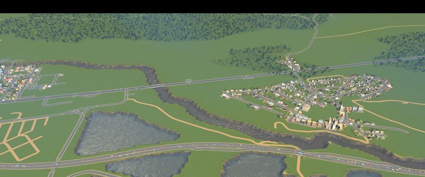
ISPRS Int. J. Geo-Inf. 2020, 9, 17 5 of 18
ISPRS Int. J. Geo-Inf. 2020, 9, x FOR PEER REVIEW 5 of 18
map into
model theaintended
playabledevelopment
model of the of given city area
the Royal [9]. The
Seaport city and
district of Stockholm
offered this inmodel
Sweden to used Cities:
the general
public, who could then explore the modeled area and contribute new ideas to the developmenttoplan
Skylines to model the intended development of the Royal Seaport district and offered this model the
general
[10]. public,visualization
Another who could thenusing explore
Cities:the modeled
Skylines wasarea and contribute
conducted new ideas toUniversity
at the Norwegian the development
of Life
plan [10].inAnother
Sciences visualization
Oslo. First, a model of using
OsloCities: Skylinesinwas
was created the conducted
game by an atexperienced
the Norwegian University
player and then of
Life Sciences in Oslo. First, a model of Oslo was created in the game by an
this model was examined by students from the point of view of urban planning and modeling [11].experienced player and then
this model
A model wasofexamined
the German by students from the point was
city of Braunschweig of view of urban
created planning
in Cities: and modeling
Skylines to simulate [11].
the
A model
production of the factories
of urban German [12].city ofIn Braunschweig was created
this research, Juraschek in [12]
et al. Cities:
choseSkylines
Cities: to simulate
Skylines forthe
its
production capabilities,
simulating of urban factories [12].
visually richInoutputs
this research, Juraschek
of simulated et al. [12] such
phenomena choseasCities:
noise Skylines
pollution, forand
its
simulating
the extended capabilities, visually
possibilities rich outputs
of amending theofgame
simulated
with phenomena
the use of such as noise
“mods”. pollution,
However, and the
regarding
extendedthe
building possibilities of amending
model, Juraschek et al.the game
[12] with
states the“As
that: useforof “mods”. However, regarding
now no automated building the
script for transferring
model,
the Juraschek
topological et al.
data [12]
into states
the game that: “As for now
is available thatno automated
produces script
high for transferring
quality results. Thisthe cantopological
make the
data intoof
creation thethegame
modelis available
very time that produces in
consuming high
thequality results.Therefore,
beginning.” This can make the to
in order creation
remove of the
model very time consuming in the beginning.” Therefore, in order to remove
obstacles in the model creation process, this research presents methods that allow for automated, the obstacles in the
model creation
simple, process,
repeatable, this research presents
and geographically accuratemethods
modeling that
of allow
most offorthe
automated,
inhabitedsimple,
locations repeatable,
on Earth
and
in geographically
Cities: Skylines. accurate modeling of most of the inhabited locations on Earth in Cities: Skylines.
2. Materials
2. Materials and
and Methods
Methods
An important
An important task
task for
for using
using Cities:
Cities: Skylines
Skylines “seriously”
“seriously” isis to
to find
find aa way
way to
to efficiently
efficiently process
process
geodata for the purposes of the game. The current tools have many limitations and
geodata for the purposes of the game. The current tools have many limitations and using them for using them for
model creation
model creation is
is time
time consuming
consuming andand complicated.
complicated. Therefore,
Therefore, the
the main
main focus
focus of
of this
this research
research was
was to
to
provide a tool that will help bridge the gap between the game and the GIS domain. This
provide a tool that will help bridge the gap between the game and the GIS domain. This tool should tool should
offer automated,
offer automated,simple
simpleto to
use,use,
repeatable, and and
repeatable, geographically accurate
geographically methods
accurate of importing
methods geodata
of importing
into the game
geodata as game
into the well asasexporting the gamethe
well as exporting objects
gameout as GIS
objects data.
out as GIS data.
The presented game mod GeoSkylines was designed to include the
The presented game mod GeoSkylines was designed to include the following
following aspects:
aspects:
•• Enable the use of any dataset of geodata (not tied directly to
to OSM).
OSM).
•• Enable formatting of the source geodata.
•• Provide a minimalistic graphics
graphics user
user interface
interface (GUI)
(GUI) so
so the
the mod
mod is less prone to breaking after
frequent game updates.
•• Give maximum focus
Give maximum focus to
to the
the accuracy
accuracy of
of the
the import
import and
and export
export methods.
methods.
In
In order
order to
to fulfil
fulfil the
the first
first two
two aspects,
aspects, the
the process
process of
of preparing
preparing the
thegeodata
geodatawas wasdone
doneseparately,
separately,
before
before running the import methods of the GeoSkylines game mod. For storing the geodata, we
running the import methods of the GeoSkylines game mod. For storing the geodata, we chose
chose
to
to use
use aa simple
simple Comma
Comma Separated
Separated Value
Value (CSV)
(CSV) format
format with
with geometry
geometry data
data recorded
recorded inin Well-Known
Well-Known
Text (WKT) format.
Text (WKT) format. Regarding
Regarding thethe third
third aspect,
aspect, the
the GeoSkylines
GeoSkylines modmod does
does not
not include
include aa GUI;
GUI;instead,
instead,
methods are activated via specified hot key combinations.
methods are activated via specified hot key combinations.
The
The overall
overall process
process of creating aa playable
of creating playable model
model in
in Cities:
Cities: Skylines
Skylines consists
consists of
of three
three stages,
stages, as
as
shown in Figure
shown in Figure 2. 2.
Figure 2. Stages of creating a model of a real-world place in Cities: Skylines using GeoSkylines methods.
Figure 2. Stages of creating a model of a real-world place in Cities: Skylines using GeoSkylines
methods.
First, using standard GIS tools, geodata are downloaded, transformed, and converted into a
suitable CSV file. Prepared CSV files are stored in the game’s default directory. This directory is also
First, using standard GIS tools, geodata are downloaded, transformed, and converted into a
the storage location for CSV files that are created as an export of the game objects, the raster image
suitable CSV file. Prepared CSV files are stored in the game’s default directory. This directory is also
of tree coverage that is used by the tree import method, CSV files used for matching the types of
the storage location for CSV files that are created as an export of the game objects, the raster image of
geographical objects to the types of game objects (e.g., road types), and a configuration file that is used
tree coverage that is used by the tree import method, CSV files used for matching the types of
geographical objects to the types of game objects (e.g., road types), and a configuration file that is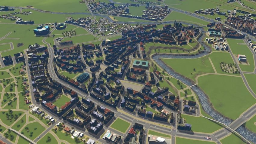
ISPRS Int. J. Geo-Inf. 2020, 9, 17                                                                                                  6 of 18

to define the latitude and longitude coordinates of the selected mid-point and other settings that help
adjust the import and export processes.
     In the second stage, a base model is created within the game’s map editor by running import
methods of the GeoSkylines game mod. All methods are described in Table 2. A full description of the
presented methods is available on development platform GitHub [37].

                                     Table 2. List of methods of the GeoSkylines game mod.

          Method Name                          Method Description                     Hot Key                     Requires
                                      Uploads roads_rwo.csv, matches road
                                                                                                               roads_rwo.csv,
                                               types according to
          ImportRoads()                                                               Ctrl + R             rwo_cs_road_match.csv,
                                      rwo_cs_road_match.csv and creates a
                                                                                                             import_export.conf
                                                 road network.
                                     Uploads rails_rwo.csv, matches rail types                                 rails_rwo.csv,
           ImportRails()             according to rwo_cs_rail_match.csv and           Ctrl + L             rwo_cs_rail_match.csv,
                                              creates a rail network.                                       import_export.conf
                                      Uploads water_rwo.csv and lowers the
        ImportWaterBody()             terrain for each polygon using the Ray          Ctrl + W        water_rwo.csv, import_export.conf
                                                 casting algorithm.
                                     Uploads waterway_rwo.csv and lowers                                     waterway_rwo.csv,
        ImportWaterWay()                                                              Ctrl + Q
                                      terrain for each waterway segment.                                     import_export.conf
                                         Uploads trees.png and for every                              trees.png (1081 × 1081 resolution),
        ImportTreesRaster()                                                           Ctrl + T
                                          non-white pixel creates a tree.                                    import_export.conf
                                     Uploads trees_rwo.csv and creates a tree
        ImportTreesVector()                                                           Ctrl + V        trees_rwo.csv, import_export.conf
                                                 for each record.
                                         Uploads zones_rwo.csv, matches                                        zones_rwo.csv,
          ImportZones()              locations of each zone with the locations        Ctrl + Z             rwo_cs_zone_match.csv,
                                     of game’s zone blocks and sets the zone.                                import_export.conf
                                       Uploads amenity_rwo.csv, matches
                                                                                                              amenity_rwo.csv,
                                           service types according to
         ImportServices()                                                             Ctrl + S            rwo_cs_service_match.csv,
                                      rwo_cs_service_match.csv and creates
                                                                                                             import_export.conf
                                                    services.
                                     Exports all road segments created in the
        ExportSegments()                                                              Ctrl + G               import_export.conf
                                              game into a CSV file.
                                     Export all buildings created in the game
        ExportBuildings()                                                             Ctrl + H               import_export.conf
                                                  into a CSV file.
                                     Exports all zones created in the game into
          ExportZones()                                                               Ctrl + J               import_export.conf
                                                     a CSV file.
                                     Exports all trees created in the game into
           ExportTrees()                                                              Ctrl + K               import_export.conf
                                                     a CSV file.
                                       Displays screen, game and WGS 84           Ctrl + left mouse
     DisplayLLOnMouseClick()                                                                                 import_export.conf
                                       coordinates of the place of the click.           click
                                     Outputs all road, building and tree types
        OutputPrefabInfo()                                                            Ctrl + P                     nothing
                                      that are currently loaded in the game.

       To achieve the best result for the created base model, the methods should be called in this order:

1.      Import terrain using the inbuilt heightmaps loader;
2.      Create game road network based on geographical road segment data;
3.      Optional step: create game rail network based on geographical rail segment data;
4.      Lower terrain to form water basins based on geographical water resources data;
5.      Create game tree coverage based on geographical tree coverage data (rasterized); and
6.      Create game services based on geographical data of services (e.g., OSM amenity data).

     The last stage of creating a playable model in Cities: Skylines involves manual post-processing
of the base model and turning it into a playable model that can run game simulations. The manual
post-processing includes fixing issues of the generated base model (e.g., caused by inaccurate geodata),
but also adding necessities such as connecting the city model to a highway (in order for new inhabitants
to move in) or adding water resources (creating water basins is automated but placing a water resource
must be done manually). The amount of time spent on manual post-processing of the base model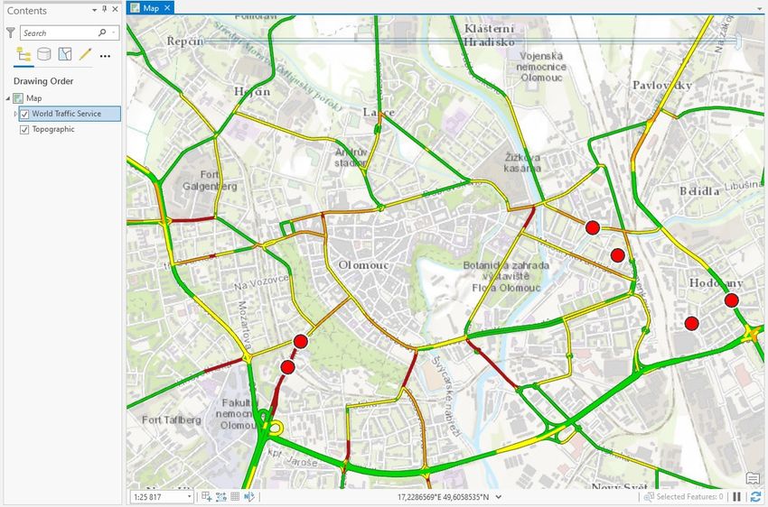
ISPRS Int. J. Geo-Inf. 2020, 9, 17                                                                 7 of 18

depends on the required level of detail. Doing the bare minimum so the model is playable can take
tens of minutes, but in cases where incorporating the greatest details (e.g., adding unique buildings)
to maximize the attractivity of the model is desired, the manual post-processing can take hours to
complete. Regardless of the case, the manual post-processing and fine tuning of the model should be
conducted by an experienced Cities: Skylines player.

2.1. Converting Geographical Coordinates into Game Coordinates
     The cornerstone of all import and export methods is the conversion of geographical coordinates
into game coordinates (and vice versa). Cities: Skylines uses cells with dimensions of 8 × 8 m; 240 ×
240 of these cells make one tile (1920 × 1920 m); 9 × 9 tiles make the maximum game area. This in
metric is 17.28 × 17.28 km, for a total area of 298.5984 squared km. However, the playable area in the
base version consists of just 5 × 5 tiles (9.6 × 9.6 km) and the maximum area can only be unlocked with
the installation of the game mod named “81 tiles”.
     The game utilizes a projected coordinate system using meters as units. This coordinate system has
three axes: x, y, and z, where the y axis, contrary to the geographical standards, stores height values
(behavior inherited from the gaming engine Unity). Axis z then serves as the ‘northing’, according to
the GIS conventions. The point of origin is in the center of the game area, thus the axes x and z range
from −8640 to 8640.
     We can consider the game’s coordinate system as a variation of the Universal Transverse Mercator
(UTM) projected coordinate system. For the actual coordinate conversion, we can then simply use
existing methods for converting WGS 84 coordinates to UTM coordinates. The overall conversion
process for import will then follow these steps:

•     Choose a 17.28 km × 17.28 km area of the modeled location;
•     Calculate the mid-point of this area;
•     Convert WGS 84 coordinates of the mid-point to UTM coordinates;
•     Convert WGS 84 coordinates of all geographical objects (roads, buildings, etc.) to UTM coordinates;
•     Game coordinates of any object created in the game then equal to UTM coordinates of this object
      minus the UTM coordinates of the mid-point;

                                               X = EO − EM                                            (1)

                                               Z = NO − NM                                            (2)

      where X and Z represent the game axes in 2D space; E represents easting; N represents northing;
      O represents the geographical object; and M represents the mid-point.

      Likewise, the conversion process for export will follow these steps:

•     Convert WGS 84 coordinates of the mid-point to UTM coordinates;
•     Calculate the UTM coordinates of the game objects:

                                                EO = X + EM                                           (3)

                                               NO = Z + NM                                            (4)

•     Convert the UTM coordinates of game objects to WGS 84 coordinates (the required UTM zone is
      obtained from the UTM coordinates of the mid-point).

2.2. Exporting Game Objects as Geographic Information System (GIS) Data
      The GeoSkylines game mod also offers methods to export game objects, specifically trees, roads,
railways, buildings, and zones. This feature could be used for data collection in participation projects
like the ones above-mentioned where players were asked to design a new suburb. Using the export
ISPRS Int. J. Geo-Inf. 2020, 9, 17 8 of 18
ISPRS Int. J. Geo-Inf. 2020, 9, x FOR PEER REVIEW 8 of 18
methods
methodsin in GeoSkylines,
GeoSkylines, the
the best
best designs
designs could
could be
be exported into GIS
exported into GIS data
data that
that could
could then
then be
be further
further
processed. As an example, Figure 3 shows the exported roads and buildings in QGIS.
processed. As an example, Figure 3 shows the exported roads and buildings in QGIS. Purple lines Purple lines
represent
representgame
gameroads
roadsand
andgrey
greypolygons
polygonsrepresent
representgame
game buildings. Exported
buildings. Exported data were
data displayed
were displayedon
top of a base map layer in the location of the city of Svit (Slovakia), which confirmed the accuracy
on top of a base map layer in the location of the city of Svit (Slovakia), which confirmed the accuracy of
the used algorithms for converting coordinates. Additionally, as visible in Figure 3, the
of the used algorithms for converting coordinates. Additionally, as visible in Figure 3, the BezierBezier curve
algorithm was employed
curve algorithm to efficiently
was employed export export
to efficiently curvedcurved
roads created withinwithin
roads created the game.
the game.
Figure3.
Figure 3. Game roads (purple) and game buildings (grey) exported
exported as
as comma
comma separated
separatedvalues
values(CSV)
(CSV)
filesand
files anddisplayed
displayed
in in QGIS.
QGIS. Characteristics
Characteristics of selected
of the the selected
game game building
building are displayed
are displayed in the
in the attribute
attribute
viewer. Theviewer. The base
base map layermap
waslayer
addedwas
foradded for geospatial
geospatial context. context.
3.3. Results
Results
We
We tested thepresented
tested the presented methods
methods by building
by building modelsmodels
of theof thebelow
cities cities inbelow in the
the game game
Cities: Cities:
Skylines:
Skylines:
• Svit, Slovakia; and
•• Svit, Slovakia;
Olomouc, andRepublic.
Czech
• Olomouc, Czech Republic.
3.1. City of Svit
3.1. City of Svit
The city of Svit (Slovakia), with a current population of 7790 inhabitants, was established in 1934 and
thusTheis relatively young.
city of Svit This citywith
(Slovakia), wasabuilt as a population
current “company town”,
of 7790according to urban
inhabitants, planning practices
was established in 1934
of that
and thus time. We recognized
is relatively young.that these
This citymodern urban
was built as aplanning
“company practices
town”,were similarto
according tourban
the simulations
planning
of the game;
practices therefore,
of that we recognized
time. We decided to select this town
that these for study.
modern urbanDue to its reasonable
planning size, this
practices were towntowas
similar the
also primarily
simulations ofused for testing
the game; the import
therefore, we and exporttomethods.
decided Coordinates
select this town for of the bounding
study. Due to itsbox represent
reasonable
an area
size, thisoftown
17.28was
× 17.28
alsokm for the selected
primarily used forlocation
testing and are shown
the import andinexport
Table 3.
methods. Coordinates of the
bounding box represent an area of 17.28 × 17.28 km for the selected location and are shown in Table 3.
Table 3. Bounding box for the Svit area.
Point Longitude Latitude
Top right 20.311757266359 49.1351685440791
Bottom left 20.060024494391 48.9909768926872
Mid-point 20.1857094521613 49.063148018262
ISPRS Int. J. Geo-Inf. 2020, 9, 17 9 of 18
Table 3. Bounding box for the Svit area.
Point Longitude Latitude
Top right 20.311757266359 49.1351685440791
Bottom left 20.060024494391 48.9909768926872
Mid-point 20.1857094521613 49.063148018262
To create a base model of Svit in Cities: Skylines, the following methods were completed:
• ISPRS Int. J. Geo-Inf.
Uploading the 2020, 9, x FOR
terrain PEER
using REVIEW
the game’s inbuilt option. A heightmap for the area was9 obtained
of 18
from Terrain.party. Instead of using a map box only restricted to a 17 km × 17 km box, we called
To create a base model of Svit in Cities: Skylines, the following methods were completed:
the Terrain.party’s API directly with exact coordinates:
• Uploading the terrain using the game’s inbuilt option. A heightmap for the area was obtained
◦ from Terrain.party. Instead of using a map box only restricted to a 17 km × 17 km box, we called
http://terrain.party/api/export?name=Svit&box=20.311757266359,49.1351685440791,20.
the060024494391,48.9909768926872
Terrain.party’s API directly with exact coordinates:
• o http://terrain.party/api/export?name=Svit&box=20.311757266359,49.1351685440791,20.0600
ImportRoads() to generate the road network in the game. OSM data with the tag “highway” were
24494391,48.9909768926872
used to prepare the roads_rwo.csv file.
• • ImportRoads() toto
ImportWaterWays() generate thewater
generate road network
basins forin waterways
the game. OSM data
in the with OSM
game. the tag “highway”
data with the tag
were used
“waterway” to prepare
were used tothe roads_rwo.csv
prepare file.
the waterway_rwo.csv file.
• ImportWaterWays() to generate water basins for waterways in the game. OSM data with the tag
• ImportWaterBody() to generate water basins for resources of standing water in the game. OSM
“waterway” were used to prepare the waterway_rwo.csv file.
data
•
with the tag “natural=water” were used to prepare the water_rwo.csv file.
ImportWaterBody() to generate water basins for resources of standing water in the game. OSM
• ImportTreesRaster()
data with the tag to generate treewere
“natural=water” coverage inprepare
used to the game. The input raster
the water_rwo.csv file.image was prepared
•
from the CORINE land cover layer. This layer was clipped according
ImportTreesRaster() to generate tree coverage in the game. The input raster image to the was
defined area and
prepared
filtered
fromto the
include
CORINE onlyland
forested
coverareas
layer.(codes 311,was
This layer 312,clipped
313). Forested
accordingareas
to thecovered
definedaarea
large part of
and
filtered modeled
the overall to include area,
only forested
resultingareas (codes 311, the
in breaching 312,limit
313). Forested areas covered
of trees created a largeTherefore,
(250,000). part
of the overall
the variable modeled area, resulting in was
ImportTreesRasterMultiply breaching
set tothe
−2,limit of treesthat
meaning created (250,000).
every secondTherefore,
creation of a
the variable ImportTreesRasterMultiply was set to −2,
tree will be skipped (i.e., dividing the total number of trees by 2). meaning that every second creation of a
tree will be skipped (i.e., dividing the total number of trees by 2).
• ImportServices() to generate services in the game. OSM data with the tag “amenity” were used to
• ImportServices() to generate services in the game. OSM data with the tag “amenity” were used
prepare the amenity_rwo.csv
to prepare file. file.
the amenity_rwo.csv
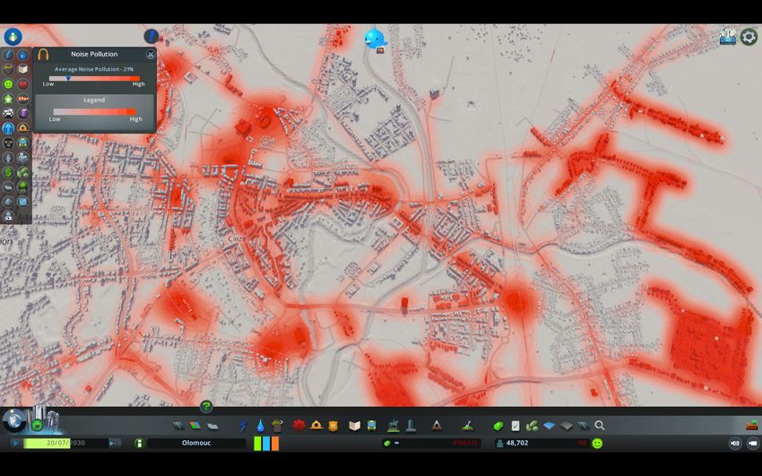
Figure 4 displays
Figure thethe
4 displays creation ofofSvit’s
creation Svit’sbase
base model inthe
model in thegame’s
game’s map
map editor
editor by calling
by calling the above
the above
GeoSkylines methods.
GeoSkylines methods.
FigureFigure 4. Creation
4. Creation of the
of the base
base modelofofSvit
model Svitfrom
from geographical
geographicaldata using
data thethe
using GeoSkylines methods.
GeoSkylines methods.
(A) An empty map after opening the map editor, (B) the map after uploading the terrain,the
(A) An empty map after opening the map editor, (B) the map after uploading the terrain, (C) (C)map
the map
after after generating
generating the the
roadroad network,and
network, and(D)
(D)the
the map
map after
aftergenerating
generating basins with
basins water
with sources
water and and
sources
tree coverage.
tree coverage.
As part of the manual post-processing of the base model, the following methods were
completed:
• Fixing issues of the created base model (e.g., due to incorrect geographical data);
• Adding water resources to created water basins;
ISPRS Int. J. Geo-Inf. 2020, 9, 17 10 of 18
As part of the manual post-processing of the base model, the following methods were completed:
• Fixing issues of the created base model (e.g., due to incorrect geographical data);
• Adding water resources to created water basins;
• Adding outside highway connections to the created road network in order for the inhabitants to
move
ISPRS into
ISPRS Int.
Int. J.
the city;
J. Geo-Inf.
Geo-Inf. 2020,
and
2020, 9,
9, xx FOR
FOR PEER
PEER REVIEW
REVIEW 10
10 of
of 18
18
• Adding zoning by using the game mod Image Overlay, which allows the display of pictures as a
•• Adding
Adding layer
transparent zoning
zoninginby by
the using
using the
the game
game. game
A mapmod
mod Image
Image
image wasOverlay,
Overlay,
createdwhich
fromallows
which Svit’sthe
allows the display
display
zoning of
of pictures
layer.pictures as
as
aa transparent
transparent layer
layer in
in the
the game.
game. A
A map
map image
image was
was created
created from
from Svit’s
Svit’s zoning
zoning layer.
layer.
Figure 5 displays thethe
Figure
resulting playable model of
of Svitafter
after manual post-processingthe of the base
Figure 55 displays
displays the resulting
resulting playable
playable model
model of Svit
Svit after manual
manual post-processing
post-processing of
of the base
base
model. Figure 6 displays a closeup of the playable model.
model. Figure 6 displays a closeup of the playable model.
model. Figure 6 displays a closeup of the playable model.
Figure
Figure
Figure 5.
5. Overview
Overviewofof
5. Overview the
ofthe resulting
resulting playable
the resulting playable
playable model of
of Svit
model
model after
of Svit
Svit manual
after after
manual post-processing
manual of
of the
the base
post-processing
post-processing of the
base
model.
model.
base model.
Figure 6. A closeup of the resulting playable model of Svit in Cities: Skylines.
Figure
Figure 6. A6. closeup
A closeup
ofofthe
theresulting
resulting playable
playable model
modelofofSvit
Svitin in
Cities: Skylines.
Cities: Skylines.ISPRS Int. J. Geo-Inf. 2020, 9, 17 11 of 18
3.2. City of Olomouc
The
ISPRScity
Int. J.of Olomouc
Geo-Inf. 2020, 9, (Czech Republic)
x FOR PEER REVIEW is the sixth biggest city in the country, with a population
11 of 18 of
100,378 inhabitants. This city is very old, especially the center, which contains many churches and
other3.2. City ofbuildings.
historic Olomouc However, the city of Olomouc has gone through significant changes in the
last few decades
The city [38]. This city
of Olomouc wasRepublic)
(Czech selected for this
is the study
sixth for city
biggest its history and size.
in the country, Coordinates
with a populationof the
bounding box representing an area of 17.28 × 17.28 km for the selected location are
of 100,378 inhabitants. This city is very old, especially the center, which contains many churches shown inand
Table 4.
other historic buildings. However, the city of Olomouc has gone through significant changes in the
Table
last few decades [38]. This city Bounding
4. selected
was forbox
thisfor the Olomouc
study area.and size. Coordinates of the
for its history
bounding box representing an area of 17.28 × 17.28 km for the selected location are shown in Table 4.
Point Longitude Latitude
TopTable
right 4. Bounding
17.4136369459021 49.6855858352729
box for the Olomouc area.
Bottom left 17.1674205694059 49.535040086535
Point Longitude Latitude
Mid-point 17.2903398559444 49.6103605031655
Top right 17.4136369459021 49.6855858352729
Bottom left 17.1674205694059 49.535040086535
To create a base model Mid-point
of Olomouc17.2903398559444
in Cities: Skylines, the following methods were completed:
49.6103605031655
• Uploading terrain using the game’s inbuilt option. A heightmap for the area was prepared in GIS
To create a base model of Olomouc in Cities: Skylines, the following methods were completed:
software from the Czech Republic’s national DEM DMR5G.
• • Uploading to
ImportRoads() terrain usingthe
generate theroad
game’s inbuiltin
network option. A heightmap
the game. OSM data for with
the area
the was prepared in were
tag “highway”
GIS software from the Czech Republic’s national DEM DMR5G.
used to prepare the roads_rwo.csv file.
• ImportRoads() to generate the road network in the game. OSM data with the tag “highway”
• ImportWaterWays() to generate
were used to prepare water basins
the roads_rwo.csv file. for waterways in the game. OSM data with the tag
“waterway”
• were used to prepare the waterway_rwo.csv
ImportWaterWays() to generate water basins for waterways file.
in the game. OSM data with the tag
• ImportWaterBody()
“waterway” wereto generate
used water
to prepare thebasins for resources
waterway_rwo.csv of standing water in the game. OSM
file.
•
data ImportWaterBody() to generate water
with the tag “natural=water” werebasins
used to forprepare
resourcestheof water_rwo.csv
standing water infile.the game. OSM
• data with the tag “natural=water” were used to prepare the water_rwo.csv
ImportTreesRaster() to generate tree coverage in the game. An input raster image was preparedfile.
•
from ImportTreesRaster() to generate
the Urban Atlas Street tree coverage
Tree layer. This layer in the
wasgame. An input
clipped raster image
according to the was prepared
defined area.
from the Urban Atlas Street Tree layer. This layer was clipped according to the defined area.
• ImportServices() to generate services in the game. OSM data with the tag “amenity” were used to
• ImportServices() to generate services in the game. OSM data with the tag “amenity” were used
prepare the amenity_rwo.csv
to prepare the amenity_rwo.csvfile. file.
Figure 7 displays
Figure thethe
7 displays base model
base modelofofOlomouc
Olomouc generated
generated ininthe
thegame’s
game’s map
map editor
editor by calling
by calling the the
aboveabove
GeoSkylines methods.
GeoSkylines methods.
Figure
Figure 7. Base
7. Base model
model of OlomoucininCities:
of Olomouc Cities: Skylines
Skylines generated
generatedbyby
calling GeoSkylines
calling methods.
GeoSkylines methods.ISPRS Int. J. Geo-Inf. 2020, 9, 17 12 of 18
ISPRS Int. J. Geo-Inf. 2020, 9, x FOR PEER REVIEW 12 of 18
As part of the manual post-processing of the base model, the following methods were completed:
As part of the manual post-processing of the base model, the following methods were
• completed:
Fixing issues of the created base model (e.g., due to incorrect geographical data);
• • Adding
Fixingwater
issuesresources to the
of the created created
base modelwater
(e.g., basins;
due to incorrect geographical data);
• • Adding water resources to the created water
Adding outside highway connections to the created basins; road network in order for the inhabitants to
• move
Adding
into outside
the city;highway connections to the created road network in order for the inhabitants to
• move into
Adding zoning theby
city;
using the game mod Image Overlay. A map image was created from Olomouc
• zoning
Addinglayer; andby using the game mod Image Overlay. A map image was created from Olomouc
zoning
zoning layer; and
• Adding unique buildings such as churches and skyscrapers.
• Adding unique buildings such as churches and skyscrapers.
Figures
Figures8 and
8 and9 9show
showthe
theresulting
resultingplayable
playable model
model ofof the
the city
citycenter
centerofofOlomouc
Olomoucafter
after manual
manual
post-processing of the base model.
post-processing of the base model.
Figure
Figure 8.8.AAplayable
playablemodel
modelof
of Olomouc
Olomouc in Cities:
Cities: Skylines
Skylines(historic
(historiccenter).
center).
Figure9.9.AAplayable
Figure playablemodel
model of
of Olomouc
Olomouc in
in Cities:
Cities:Skylines
Skylines(river
(riverview).
view).ISPRS Int. J. Geo-Inf. 2020, 9, 17 13 of 18
ISPRS Int. J. Geo-Inf. 2020, 9, x FOR PEER REVIEW 13 of 18
ISPRS Int. J. Geo-Inf. 2020, 9, x FOR PEER REVIEW 13 of 18
Aside from the physical visualizations, we also explored several game simulations in the created
Aside from
Aside from the
the physical
physical visualizations,
visualizations, we
we also
also explored
explored several
several game
game simulations
simulations in
in the
the created
created
model of
model of
Olomouc. Figure
of Olomouc. Figure
10 displays
Figure 10
the
10 displays
simulated
displays the
noise
the simulated
pollution
simulated noise
in the
noise pollution
pollution in
Olomouc
in the
model.
the Olomouc
According
Olomouc model.
model.
model
to the game’sOlomouc.
According algorithms,
to the game’s noise pollution
algorithms, is pollution
noise affected by
is traffic, industry,
affected by commercial
traffic, industry, zones, andzones,
commercial specific
According to the game’s algorithms, noise pollution is affected by traffic, industry, commercial zones,
types of buildings
and specific
specific typessuch
types of as power
of buildings plants.
buildings such
such as
as power
power plants.
plants.
and
Figure
Figure 10.Simulated
10.10.
Figure Simulatednoise
Simulated noisepollution
noise pollution in
pollution in the Cities: Skylines’
Cities: Skylines’
the Cities: model
Skylines’model ofofOlomouc.
modelof Olomouc.
Olomouc.
Inhabitantsofof
Inhabitants
Inhabitants ofthe
themodel
the model of
model of Olomouc
Olomouc utilize
Olomoucutilize
utilizethe road
the
the system
road
road to travel
system
system to travel to work,
to travel
to work, school,
to work, shops,shops,
school,
school, shops, etc.
etc.
The
etc.The game
Thegame individually
gameindividually
individually tracks the
tracks passage
the passageof every
of everycitizen’s
citizen’svehicle
vehicleas well
as wellas service
as and
service
tracks the passage of every citizen’s vehicle as well as service and freight andfreight
freight
vehicles.InIn
vehicles.
vehicles. Inthe
thetraffic
the trafficinfo
traffic infoview,
info view, the
view, the player
the player can
player can observe
can observe the
observe the traffic
thetraffic flow
trafficflow ofofeach
flowof each road
eachroad and
roadand
andidentify
identify
identify
problematic
problematic parts
parts ofof the
the road
road system.
system. Figure
Figure 1111displays
displays the traffic
the info
traffic view
info for
view the
for
problematic parts of the road system. Figure 11 displays the traffic info view for the created model created
the model
created of
model
of
Olomouc.
of Olomouc.
Olomouc.
Figure 11.
Figure 11. Traffic
Traffic info
info view
view of
of the
the Cities: Skylines’
Skylines’ model of
of Olomouc.
Figure 11. Traffic info view of the Cities: Skylines’model
model ofOlomouc.
Olomouc.ISPRSInt.
ISPRS Int. J.J. Geo-Inf.
Geo-Inf. 2020,
2020, 9,
9, 17
x FOR PEER REVIEW 1414ofof18
18
Although the average traffic flow is at an acceptable rate, there are several problematic parts
Although the average
where the traffic traffic
congestion is flow
high.is at an acceptable
Examples rate,congestion
of high there are several
areas problematic
are Masarykovaparts where
třída,
the traffic congestion is high. Examples of high congestion areas are Masarykova
Komenského, and Chválkovická Streets, or the intersection at Náměstí Hrdinů. For comparison,třída, Komenského,
and Chválkovická
Figure 12 displaysStreets, or the intersection
Environmental at Náměstí
Systems Research Hrdinů. (ESRI)
Institute’s For comparison, Figure
World Traffic 12 displays
Service layer
Environmental Systems Research Institute’s (ESRI) World Traffic Service layer (source
(source data provided by HERE Maps) where we can observe the authentic traffic situation in data provided by
HERE Maps) where we can observe the authentic traffic situation in Olomouc. This layer
Olomouc. This layer identifies the same problematic parts of the Olomouc road network as the ones identifies the
same problematic
identified parts ofsimulations.
by the game’s the Olomouc road network as the ones identified by the game’s simulations.
Figure12.
Figure 12. Environmental
Environmental Systems Research Institute’s
Institute’s (ESRI)
(ESRI) World
World Traffic Service layer
layer displaying
displaying
thetraffic
the trafficsituation
situationin
inOlomouc.
Olomouc.
The
The GeoSkylines
GeoSkylines game
game mod’s
mod’s code,
code, detailed documentation for running
running thethe import
import and
and export
export
methods,
methods,examples
examplesofofconfiguration andand
configuration input CSVCSV
input files files
as well
as as all of
well as the
all resulting base andbase
of the resulting playable
and
models are available on development platform GitHub [37].
playable models are available on development platform GitHub [37].
4.4. Discussion
Discussion
Cities:
Cities: Skylines
Skylinesisiscurrently
currently thethe
most advanced
most advanced city-building
city-buildinggame on the
game onmarket. This game
the market. offers
This game
features such as a visually appealing 3D graphics environment, a mass transit
offers features such as a visually appealing 3D graphics environment, a mass transit system, andsystem, and agent-based
simulations
agent-basedthat present city
simulations related
that processes
present somewhat
city related realistically.
processes somewhatDue to these possibilities,
realistically. Due to Cities:
these
Skylines has begun to be used for non-entertainment purposes. In all of the case
possibilities, Cities: Skylines has begun to be used for non-entertainment purposes. In all of the casestudies identified,
astudies
model identified,
of a real-world placeofwas
a model created from
a real-world geographical
place was created data.
fromThe resulting model
geographical data. was
The then used
resulting
either
modelfor
was participation,
then used eithereducation, or urban modeling
for participation, education,projects
or urban[9–12].
modelingHowever, the
projects model
[9–12]. creation
However,
process has been described as complicated and lengthy [12]. The lack of tools
the model creation process has been described as complicated and lengthy [12]. The lack of tools processing geodata for
the purposesgeodata
processing of Cities:
forSkylines is preventing
the purposes of Cities:aSkylines
wider use of the gamea in
is preventing non-entertainment
wider use of the gameways.
in non-
Therefore,ways.
entertainment utilizing the game’s modding API, we developed simple to use import methods to
createTherefore,
a base model in Cities:
utilizing Skylines
the game’s accurate,
modding fast,
API, weautomated,
developedand repeatable
simple by using
to use import prepared
methods to
geodata. During
create a base modelthe in
development
Cities: Skylinesof the presented
accurate, fast,methods,
automated, maximum focus was
and repeatable given prepared
by using to enable
the creation
geodata. of as the
During many game objects
development as possible
of the presentedwith the highest
methods, achievable
maximum focusaccuracy.
was givenThe presented
to enable the
methods created road and rail networks, water basins, a tree coverage, zones, and
creation of as many game objects as possible with the highest achievable accuracy. The presented services. An accurate
conversion of the geographical
methods created road and railcoordinates
networks, waterof the basins,
source data
a treetocoverage,
the game zones,
coordinates of the game
and services. AnISPRS Int. J. Geo-Inf. 2020, 9, 17 15 of 18
objects was achieved by implementing a standard conversion algorithm between the coordinate
systems WGS 84 and UTM and then by simple recalculation of the UTM coordinates into the game
coordinates (and vice versa). The conversion accuracy is confirmed in Figure 3, where the game objects,
exported from the model of Svit and displayed in GIS software, properly aligned with the added
base layer.
However, to create a playable model, manual post-processing of the base model is required.
This process might include:
• Fixing issues of the base model (e.g., due to incorrect source geographical data or the code’s
inability to efficiently generate complex parts of the model such as tunnels).
• Adding necessities such as connecting the city to a highway for new inhabitants to move in or
adding water resources.
• Zoning in the case where GeoSkylines’s method ImportZones() cannot be used (e.g., vector layer
of zoning for the selected location is not available).
• Adding unique buildings such as churches and skyscrapers.
• Adjusting the game simulations by implementing selected game mods.
The amount of time spent on manual post-processing of the base model depends on the size of
the model and required level of detail. Adding the necessities so that the model is playable can take
tens of minutes. However, for a large model where a great level of detail is required, the manual
post-processing can take hours to complete. To mitigate the amount of time spent on the manual
post-processing, it is recommended that this activity is completed by an experienced Cities: Skylines
player. The fact that manual post-processing is still required for the creation of the playable model in
Cities: Skylines is a limitation. Nevertheless, by employing the presented methods, the complexity
and the time spent on the creation of such a model decreases significantly.
Using the presented methods, we built playable models of the cities of Svit (Slovakia) and Olomouc
(Czech Republic). The creation of the playable model of Svit took approximately 40 min because the
modeled city is relatively small, and the planned level of detail of the model was set to low. The creation
of the playable model of Olomouc took approximately 8 h because the city is much larger than Svit,
and the planned level of detail of the model was set higher than in the case of Svit.
When creating roads—either by script or manually—the game automatically creates zone blocks
along them. These zone blocks can then be assigned with one of the available zones in the game:
residential low, residential high, commercial low, commercial high, office and industrial. After setting
the zones, the game starts to automatically construct the buildings. This automated creation of
buildings speeds up the overall model creation, on the other hand, the look of the resulting model is
more generalized. The game offers many features to increase the visual accuracy of the model. Among
others, unique buildings such as churches or skyscrapers can be added to the model. Unique buildings
can be created in the game’s asset editor or imported from 3D modeling software. Selected game
mods allow the player to construct each individual building. Although all these options are very
time consuming, we recommend utilizing them if the purpose of the model in Cities: Skylines is the
visualization of a city or part of it.
If, however, the purpose of the model is to run simulations, then a high level of detail of visual
accuracy is not necessary as the looks of the buildings and other game objects do not affect the
simulations. In some cases, the visual accuracy can even be contradictory to the game simulations.
For example, the university complex in Olomouc consists of several buildings, but the university in
the game is represented by a single building. Hence, adding another university building to the game
to comply with the visual accuracy would affect the simulation logic. Uploaded terrain also has a
minimal effect on the game simulations and serves rather as an aesthetic feature. The created model of
Olomouc consisted of parts where the visual accuracy was relatively high as well as parts where the
visual accuracy was reduced in favor of the game simulations.You can also read