Bushfire Management Strategy - for Council Owned and Controlled Land Clarence City Council
←
→
Page content transcription
If your browser does not render page correctly, please read the page content below
Clarence City Council

Bushfire Management Strategy
for Council Owned and Controlled Land

                                        Revised
                                  January 2017
                           Clarence City Council
Contents
                                                                                                                                                Page

1.   Clarence City Council Bushfire Management Policy .................... 2

2.   Introduction ............................................................................................ 3

3.   Recommendations ................................................................................. 5

4.   Structure of the Bushfire Management Strategy ............................ 7

5.   Review of the Previous Strategy ...................................................... 10

6.   Bushfire Management Strategy (BMS) ........................................... 18
      6.1     Adaptive Management Approach .....................................................................................18
      6.2     Preparedness .........................................................................................................................19
      6.3     Mitigation ..............................................................................................................................20
      6.4     Response ................................................................................................................................21
      6.5     Recovery ................................................................................................................................22
      6.6     Municipal Fire History ........................................................................................................23
                6.6.1        Bushfire History ...................................................................................................23
                6.6.2        Planned Burn History 1984&2015 .......................................................................24

7.   Statutory Responsibilities ................................................................. 26
      7.1     National Standards and Guidelines...................................................................................32

8.   Implementation of the Strategy........................................................ 33
      8.1     Administration .....................................................................................................................33
                8.1.1        Responsibility for Implementing the Bushfire Management Strategy .........33
                8.1.2        Training .................................................................................................................34
                8.1.3        Coordination and Consultation .........................................................................34
                8.1.4        Resources ..............................................................................................................34
      8.2     Use of Fire in the Sustainable Management of Bushland ...............................................35
      8.3     Bushfire Hazard Reduction ................................................................................................38
                8.3.1        Defendable Spaces ...............................................................................................38
                8.3.2        Hazard Reduction on Private Property ............................................................40
                8.3.3        Vineyards and Smoke Taint ...............................................................................40
8.4        Bushfire Risk Assessment ...................................................................................................40
           8.5        Likely Effect of Climate Change on Bushfire Risk ...........................................................46
           8.6        Community Involvement ....................................................................................................46
           8.7        Community Education and Awareness ............................................................................47
                         8.7.1        Rubbish Dumping in Reserves...........................................................................48
           8.8        Liaison with the Tasmania Fire Service (TFS) ..................................................................48
           8.9        Threatened or Rare Species .................................................................................................49
           8.10       Cultural Heritage .................................................................................................................49
           8.11       Monitoring and Evaluation.................................................................................................49
                         8.11.1 Performance Indicators .......................................................................................50
           8.12       Maintaining Records ............................................................................................................51
                         8.12.1 Bushfire Management Activities........................................................................51
                         8.12.2 Fire Management Geographic Information System (GIS) Context ...............51
           8.13       Review of the Bushfire Management Strategy .................................................................51
                         8.13.1 Revision of the Bushfire Management Plans (BMPs)......................................52

Bibliography
Glossary

Appendix A - Best Management Practice Guidelines
Appendix B - Reserve Bushfire Management Plans (BMPs)
Appendix C – 5 Year On-Ground Works Schedule
Appendix D – Summary of Comments

                                                                       FIGURES
Figure 1 – City of Clarence boundary ...........................................................................................................1

Figure 2 – Fire and Bushland Management objectives ...............................................................................3

Figure 3 – Municipal areas classified as bushfire&prone under the Clarence Interim Planning Scheme
      2015 ............................................................................................................................................................4

Figure 4 – Council’s adaptive approach .....................................................................................................19
TABLES Table 1 – Annual operational deliverables by Council’s Fire and Bushland Management Team......10 Table 2 – Municipal bushfire history (1967&2013) .....................................................................................23 Table 3 – Municipal planned burns conducted (1984&2015) ....................................................................24 Table 4 – Municipal hectares burnt through planned burning (1984&2015) ..........................................25 Table 5 – CCC scheduled planned burns with area (2016&2021) .............................................................25 Table 6 & Tasmanian FDR system ................................................................................................................38 Table 7 –BMP revision procedures ..............................................................................................................52
Clarence City Council Bushfire Management Strategy for Council Owned and Controlled Land Revision 3, January 2017
1. Clarence City Council Bushfire Management
Policy
Clarence City Council Bushfire Management Policy
(Adopted 2004)
In order to fulfil its responsibilities as a landowner, and in recognition of its community
role in land management Clarence City Council will:
Implement current recommended practices for bushfire risk management on all land
under its control.
Encourage all owners of private and public bushland areas within Clarence to
implement current recommended practices for bushfire risk management.
Meet all its statutory obligations for bushfire management.
Educate the Clarence community regarding the risks from bushfires in collaboration
with the Tasmania Fire Service (TFS).
Consult with community and other stakeholders when planning bushfire
management activities on Council managed land.
Use planned burning as a management tool in areas to reduce bushfire risk, and
maintain and enhance biodiversity.
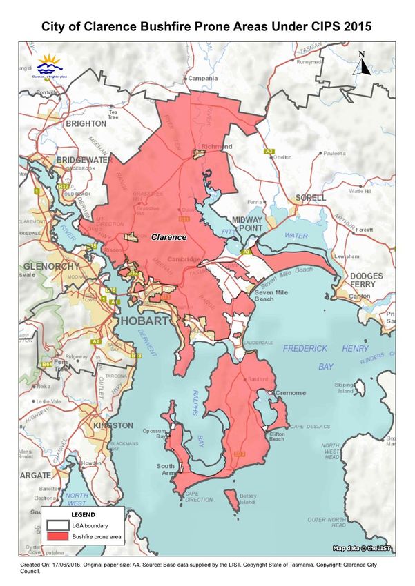
Clarence City Council 2Clarence City Council Bushfire Management Strategy for Council Owned and Controlled Land Revision 3, January 2017 2. Introduction This Bushfire Management Strategy (BMS) has been prepared by Clarence City Council’s Fire and Bushland Vegetation Management Team. It is the third revision and expansion of Clarence City Council’s existing BMS which commenced in 1997. This review builds on previous methodologies and principles as still valid, and is heavily influenced by a multi(agency approach, targeting areas for maximum risk reduction, utilising Geographic Information Systems (GIS) and increasing Council’s Fire and Bushland Management Team’s operational outputs. Council’s BMS has been developed to assist in delivering a holistic management approach to mitigating impacts from a low probability but high impact event to the municipality ( bushfire. Not being able to predict such high impact events creates the need for resilience thinking. The aim of this revision is to ensure that Council’s bushfire management practices are based on current recommended practices for protecting life and assets from bushfires, and to maintain and enhance biodiversity within land managed by Council. Council’s BMS addresses bushfire management challenges that have arisen from the expansion of residential developments within bushland areas, community concerns at the potential threat of bushfire, on ground works and associated operational restrains, wider awareness of the ecological role of fire, and the statutory responsibilities of Local Governments in bushfire hazard management. As of December 2015, approximately 78% of the Clarence municipality has been classified as bushfire(prone (see figure 3) under the Clarence Interim Planning Scheme 2015. Any future developments within mapped areas may require a Bushfire Risk Assessment and a Bushfire Hazard Management Plan. Figure 2 – Fire and Bushland Management objectives Clarence City Council 3
Clarence City Council Bushfire Management Strategy for Council Owned and Controlled Land   Revision 3, January 2017

Figure 3 – Municipal areas classified as bushfire prone under the Clarence Interim Planning
Scheme 2015

Clarence City Council                                                                                            4
Clarence City Council Bushfire Management Strategy for Council Owned and Controlled Land   Revision 3, January 2017

3. Recommendations
The review makes 10 recommendations as follows:

Recommendation 1
The permanent creation of a Technical Fire and Bushland Management Team position to provide
specialised operational and technical advice to internal and external stakeholders.

Recommendation 2
     •     Advancement of Fire and Bushland Management Team’s certified Tree Fallers from
           intermediate to advanced qualification.
     •     Develop advanced land management, and fire and ecology qualifications within Fire and
           Bushland Management Team.

Recommendation 3
     •     Replacement of 2wd Fire and Bushland Management Team’s vehicle to 2 door 4wd Toyota
           Land Cruiser ute or similar.
     •     Future Fire and Bushland Management Team’s vehicles to be replaced with 4wd Toyota
           Land Cruiser utes or similar.
     •     Permanent allocation of mud(terrain tyres on all Fire and Bushland Management Team’s
           vehicles.
     •     Further investigation into procurement of dedicated 4wd Fire and Bushland Management
           Team water cart for planned burning with minimum 3000l water capacity.

Recommendation 4

Specialist plant and machinery operators are included in the Plant and Equipment section of the
Multi Use Registrar to suit operational and legislative requirements.

Recommendation 5
Annual meetings held between Council’s Fire and Bushland Management Team, Landcare and
Coastcare groups to discuss relevant annual planned works.

Recommendation 6
During future developments of Bushfire Management Plans (BMPs) and Reserve Activity Plans
(RAPs), Council’s Fire and Bushland Management Team, Natural Resource Management and
consultants are to be involved at consultation stage to alleviate conflicting recommendations.

Recommendation 7
Council’s Fire and Bushland Management Team develop and implement a community awareness
and education program structured on the 2016(2021 BMS.

Clarence City Council                                                                                            5
Clarence City Council Bushfire Management Strategy for Council Owned and Controlled Land Revision 3, January 2017
Recommendation 8
• Council’s Fire and Bushland Management Vegetation Monitoring Program (VMP) be
further incorporated into Council’s Fire Management GIS context.
• Expansion of the VMP to include threatened species.
• Future Development of VMP to be in consultation with the Threatened Species Section of
Department of Primary Industries, Parks, Water and Environment (DPIPWE), and in
accordance with any conditions attached to a permit to take threatened species.
Note: For successful implementation of recommendation 8, recommendation 1 is to be
implemented prior.
Recommendation 9
Implement recommendation 1 to allow for accurate internal and external annual dataset sharing,
and database management for Council’s Fire and Bushland Management Team operations.
Recommendation 10
• Council with guidance from TFS to investigate a formalised additional vehicle escape
route for residents living at Mt Rumney.
• Future subdivisions within and adjacent to Mt Rumney to consider allowing a vehicle
escape route for residents living at Mt Rumney.
• Future BMS reviews undertaken internally by Council’s Fire and Bushland Management
Team.
Clarence City Council 6Clarence City Council Bushfire Management Strategy for Council Owned and Controlled Land Revision 3, January 2017 4. Structure of the Bushfire Management Strategy This third revision maintains the previous structure; an introductory strategy document, a set of best management practices guidelines (Appendix A), BMP’s for individual reserves including a summary of community concerns and comments (Appendix B), a five year on(ground works schedule to assist with planning and budgeting (Appendix C), and a summary of comments document (Appendix D). The BMS identifies all of Clarence City Council’s statutory bushfire management responsibilities, sets overall objectives and confirms a policy framework, and outlines the practices, procedures and actions required to meet them. It also includes general information on bushfire management, details of the bushfire risk assessment process used in the reserve BMPs, including assumptions, methods and data sources, and a glossary of key terms. The ‘adaptive management’ approach recommended in this strategy will help overcome the lack of information on the long(term responses of the vegetation to fire. During 2012 Council’s Fire and Bushland Management Team established and annually re(assess a VMP specific to the treatments recommended under the BMS. This program will assist to provide long term data sets to support treatments or modify post evaluation (see section 6.1 and 8.11). Appended to this strategy are the following: A) Best Management Practice Guide lines These provide guidelines and procedures for the following bushfire management activities: • fire trail construction • fire trail inspection and maintenance • trail closure and rehabilitation (for trails no longer required for bushfire management) • foot track construction, inspection and maintenance (where used for bushfire management) • creating a defendable space from bushfires • maintaining defendable spaces • planned burning • weed control before and after burning • coordinating bushfire management activities with other management activities • recording fires • recording bushfire management activities • post fire recovery. Clarence City Council 7
Clarence City Council Bushfire Management Strategy for Council Owned and Controlled Land   Revision 3, January 2017

B) Reserve Bushf ire Management Plans (BMPs)
This appendix contains revised BMPs for the following Clarence City Council reserves:

•    Bedlam Walls Reserve
•    Canopus(Centauri Bushland Reserve

•    Glebe Hill Reserve (incorporating additional 3.4 hectares formerly 50 Minno Street, Howrah)
•    Rokeby Hills Reserve (formerly Kuynah Bushland Reserve, incorporating Toorittya Bushland
     Reserve, and an additional 32 hectares of Public Open Space throughout Rokeby Hills)

•    Lauderdale Wetlands Reserve
•    Mortimer Bay Coastal Reserve

•    Natone Hill Bush Park
•    Pilchers Hill Reserve
•    Roches Beach Coastal Reserve and Nowra Bushland Reserve
•    Rosny Foreshore Reserve

•    Rosny Hill Reserve
•    Roscommon Reserve

•    Seven Mile Beach Coastal Reserve

•    Waverley Flora Park

New plans for the following reserve:

•     Wiena Reserve

The four following reserves have had BMPs removed as they are either not bushfire(prone,
managed vegetation, or the land is no longer managed by Council:

•     Bellerive/Howrah Foreshore
•     45 and 45A Goodwins Road
•     Gordons Hill Reserve
•     Lauderdale Dunes

These plans recommend treatments for the use of fire as a management tool in each reserve for the
next five years to:

•    target area for maximum risk reduction

•    reduce bushfire hazard to protect assets from bushfires

•    maintain the long(term viability of the ecosystems in each reserve

•    assist in the removal of weeds and the regeneration of degraded bushland.

Clarence City Council                                                                                            8
Clarence City Council Bushfire Management Strategy for Council Owned and Controlled Land Revision 3, January 2017 The long(term effects of fire on the habitats of native flora and fauna in Australia are still imperfectly understood. However, available information on the fire ecology of plant communities, and indigenous flora and fauna species within Clarence City Council reserves has been incorporated into the BMPs. Where the required information has not been available, recommendations in the plans are based on a precautionary approach. It must be noted that it will not be possible to prevent bushfires impacting land managed by Clarence City Council. On days of low(moderate Fire Danger Rating (FDR) suppression of small fires is possible, however on days of very high or above FDR fires will be unpredictable, uncontrollable and fast(moving, with potential to burn substantial areas of the reserves causing damage to assets, environmental values, and even loss of life. These fires may also impact adjoining land, further threatening life and assets. FDR ratings above severe occur in Tasmania around three times a year. Ratings above extreme have occurred only half a dozen times in Tasmania during the last 90 years. However, with the impact of climate change, the potential for such days is increasing (TFS, 2016). The Australian Standard for Construction of buildings in bushfire(prone areas (AS:3959 – 2009) uses a FDR of 50 to determine the Bushfire Attack Level (BAL) for buildings that need to comply with the standard. An FDR of 50 is the boundary between Very High and Severe Fire Danger Rating. The BMPs aim to mitigate impacts from bushfire by reducing and managing fuel loads and associated risks influencing ignitions and spread of fire within Council reserves, and in turn reduce the risk of loss of life, property or assets in and around the reserves. Properties and assets adjacent to reserves will need to be maintained by owners as defendable spaces (section 8.3.1) as outlined in the TFS document Bushfire Survival Plan 2015&16 or its most current successor. C) 5 Ye ar On&Ground Works Schedule This appendix lists the on(ground works recommended in each reserve BMP during 2016(2021, along with the scheduling of the works and the approximate length or area covered. It is designed to assist implementation and budgeting of on(ground bushfire management activities. D) Summary of Comments This appendix summarises submissions on the draft revised Bushfire Management Strategy and reserve BMPs by the community and other stakeholders. Clarence City Council 9
Clarence City Council Bushfire Management Strategy for Council Owned and Controlled Land                    Revision 3, January 2017

5. Review of the Previous Strategy
As part of this revision a review of the implementation of the previous strategy was undertaken;
particularly the reserve BMPs.
The reviewed 2016(2021 BMPs have been derived from an operational approach, planning for
future developments and sub(divisions, not just a “tick box” exercise. This approach has the key
objective of creating a holistic end process.

The detailed results of the review are included in the revised BMPs, and are summarised below.

Establishment of full time Fire and Bushland Vegetation Management Team:
During 2012 Council established a permanent full time Fire and Bushland Vegetation Management
Team. The team consists of a Co(ordinator, Works Officer and three Fire and Bushland Workers.
This has allowed Council to meet requirements under the Fire Service Act 1979 whilst: allowing
continuity of treatments and programs, retainment of specialised municipal knowledge and
experience previously lost through seasonal crew positions. For example annual maintenance
programs of defendable spaces.

  Table 1 – Annual operational deliverables by Council’s Fire and Bushland Management Team

Bushland managed                                                                       Approximately 1400 hectares

Defendable spaces maintained                                                           Approximately 60 hectares

Area broadscale burnt though planned burning                                           Approximately 20 hectares

Area thinned and heap burnt                                                            Approximately 15 hectares

Fire trail network managed                                                             Approximately 300 kilometres

Crew:
Crew operational experience is at a high standard. The fulltime status has allowed continuity of
annual work programs. Crew has sound knowledge of bushland reserves and annual maintenance
programs. The current structure of Council’s Fire and Bushland Management Team could be
strengthened by the permanent creation of a Technical Fire and Bushland Management position,
reporting to the Fire and Bushland Vegetation Management Coordinator. The operational outputs
would be maintained by a Fire and Bushland Vegetation Management Works Officer with two Fire
and Bushland Vegetation Management Workers (this is the current temporary Fire and Bushland
Management Team structure at time of review) i.e. The number of positions in the establishment
would remain the same.

Recommendation 1
The permanent creation of a Technical Fire and Bushland Management Team position to provide
specialised operational and technical advice to internal and external stakeholders.

Clarence City Council                                                                                                           10
Clarence City Council Bushfire Management Strategy for Council Owned and Controlled Land   Revision 3, January 2017

Training:
Crew skills are at a good standard to meet operational requirements at time of review. Succession
planning is in place and will continue thorough out duration of revised strategy. Advancement of
certified Tree Fallers from intermediate to advanced qualifications is recommended, in addition
developing advanced land management, and fire and ecology qualifications within work group.
Challenges are ongoing in resourcing specialised fire management training.

Recommendation 2
     •     Advancement of Fire and Bushland Management Team’s certified Tree Fallers from
           intermediate to advanced qualification.
     •     Develop advanced land management, and fire and ecology qualifications within Council’s
           Fire and Bushland Management Team.

Fire and Bushland Management Vehicles:
1)       At time of review Fire and Bushland Management Team are allocated three vehicles:
         • 2 door 4wd firefighting vehicle (Co(ordinator)
         • 2 door 2wd vehicle (Works Officer)
         • 4 door 4wd firefighting vehicle (Fire Crew)

      Until 2015 Fire and Bushland Management Team was allocated only two vehicles (co(
      ordinator and crew vehicle), this created gross vehicle mass (GVM) weight restrictions for the
      crew vehicle. On a daily basis the crew vehicle would have four members, associated personal
      protective equipment, equipment and a permanent 500kg fire fighting tanker. The one crew
      vehicle allocation also reduced operational outputs through not being able to be split and
      complete multiple tasks at a given time.
      The third vehicle (Works Officer) was allocated in 2015 and now enables Fire and Bushland
      Management to maximise operational outputs. The weight restriction also has been alleviated
      through splitting the crew and equipment between the Crew and Works Officer vehicles.

2)    Majority of operational work is in bushland reserves which post rain and during winter
      become slippery. Recommend permanent allocation of mud terrain tyres to all Fire and
      Bushland Management Team vehicles.
      Recommend 2wd vehicle be replaced with 4wd vehicle.

3)    Low range gear ratio on current 4wd vehicles is not appropriate for operational use, being too
      high geared. When working in steep bushland areas with a 500kg fire fighting unit a lower
      gear ratio (similar to that in Toyota Land Cruisers) is more suited for controlling vehicles
      traction down fire trails.
      Recommend future Fire and Bushland Management Team vehicle replacements are 4wd
      Toyota Land Cruiser utes or similar as low range gear ratios more suitable for operational
      requirements.

Clarence City Council                                                                                          11
Clarence City Council Bushfire Management Strategy for Council Owned and Controlled Land Revision 3, January 2017
The resource sharing of Council’s Civil Construction water cart truck for planned burning
poses operational restraints. Currently Fire and Bushland Management Team provide very
limited notice for requirement of water cart to Civil Construction.
This is due to associated planned burning weather restraints. This creates flow on disruptions
to Civil Constructions planned work programs.
Recommend when possible, Fire and Bushland Management Team notify Civil Construction
of intent to burn dependant on weather.
Recommend further investigation into procurement of dedicated 4wd Fire and Bushland
Management Team water cart for planned burning with minimum 3000l water capacity.
Recommendation 3
• Replacement of 2wd Fire and Bushland Management Team’s vehicle to 2 door 4wd Toyota
Land Cruiser ute or similar.
• Future Fire and Bushland Management Team’s vehicles to be replaced with 4wd Toyota
Land Cruiser utes or similar.
• Permanent allocation of mud(terrain tyres on all Fire and Bushland Management Team’s
vehicles.
• Further investigation into procurement of dedicated 4wd Fire and Bushland Management
Team water cart for planned burning with minimum 3000l water capacity.
Contracted Plant and Machinery
With the constant expansion of bushfire(prone areas managed by Council’s Fire and Bushland
Management Team (see table 1), operational restraints arose with maintaining defendable spaces
during fire permit periods, and meeting legislative requirements. A posi track Bobcat with front
deck slasher and excavator with drum mulcher is now contracted annually during the fire permit
period as required to complete the annual slashing program on time.
Council’s operational Fire and Bushland Management Team also runs an annual brushcutting
program for defendable spaces.
Recommendation 4
Specialist plant and machinery operators are included in the Plant and Equipment section of the
Multi Use Registrar to suit operational and legislative requirements.
Defendable Spaces:
At time of review Fire and Bushland Management Team annually manage approximately 60
hectares of defendable spaces to current TFS guidelines. Ongoing annual maintenance is required
and occurring. Operational restraints towards maintenance and establishment of defendable
spaces are evident, works programs are based on a relative risk ranking.
Clarence City Council 12Clarence City Council Bushfire Management Strategy for Council Owned and Controlled Land Revision 3, January 2017 The BMS review has identified areas requiring re(establishment of defendable spaces; these have been outlined in Appendix C. Revegetation planting occurred in some defendable spaces by Landcare Groups and adjacent land owners. This, in most circumstances, makes the defendable spaces non(compliant with guidelines and maintenance more costly. Annual meetings and information sessions with stakeholders in targeted areas should alleviate reoccurrences. Recommendation 5 Annual meetings held between Council’s Fire and Bushland Management Team, Landcare and Coastcare groups to discuss relevant annual planned works. Fire Trails: All fire trails included in BMPs have had regular inspections with maintenance implemented as specified on an operational needs basis. Signposting of all fire trails was recommended during the previous BMS, this has since been re(evaluated and only those fire trails identified as strategic under the Hobart Fire Protection Plan (noted in BMPs) will be signposted. This will allow for less confusion when navigating larger bushland reserves, as strategic fire trails are the main access routes. During 2015 and 2016 an extensive upgrade and establishment program was implemented. At time of review the fire trail network within the strategy is of high standard. The amended Glebe Hill Reserve and Rokeby Hills Reserve polygons (since 2016 Council acquirement of additional land) will need upgrade/maintenance to meet most current operational requirements to manage defendable spaces, manage weed populations and allow access for the TFS. Council’s Fire and Bushland Management Team is seeking written approval as specified in respective Conservation Covenants at time of strategy review. Prior to the establishment of Council’s Fire Management GIS context (developed during 2013), very limited data was available to identify formalised fire trail networks on Council land. The most current fire trail data has been included during the review and will be shared, in addition with reviewed BMPs, with all Council staff to clearly delineate fire trail networks within BMPs. Bushfires: Since the last strategy revision in 2011 there has been no large destructive bushfires to impact any reserves covered by BMPs. During March 2013, approximately 500 hectares of dry sclerophyll forest burnt throughout the Meehan Ranges originating from Downhams Road, Risdon Vale. The fire did not directly impact Pilchers Hill Reserve; however reestablishment and establishment of containment lines did occur in sections of Vegetation Management Unit (VMU) 7. Natone Hill Bush Park, Waverley Flora Park, Nowra Bushland Reserve, Seven Mile Beach Coastal Reserve all experienced bushfires less than 1 hectare during the last review. There have been no reports of damage to assets in, or adjoining reserves included in the BMS due to bushfires. Clarence City Council 13
Clarence City Council Bushfire Management Strategy for Council Owned and Controlled Land   Revision 3, January 2017

Planned Burning:
53 planned broadscale burns were conducted during the previous BMS by Council’s Fire and
Bushland Management Team covering approximately 136 hectares (see Table 3 and 4). No planned
burns escaped, nor were any assets damaged by the planned burns. In addition approximately 40
hectares annually of bushland underwent planned burning utilising the heap burning regime
(thinning vegetation and burning in bonfires). All historical planned burns and bushfire records
have been updated on Council’s Fire Management GIS context during the review process. In
addition, Council’s Fire and Bushland Management Team have developed a new Operational Burn
Plan form (document stating how each planned burn will be undertaken, including special values,
lighting techniques etc.) during the BMS review.

Management of Council managed land:
Management of Council managed land needs to be better coordinated and communicated to all
stakeholders to avoid conflicting management approaches including:

    •      Community groups (official and unofficial) planting trees and shrubs in areas that are
           identified as defendable spaces and fire trails in BMPs.

    •      Council Operations Groups (Fire and Bushland Management Team, and Parks and
           Community Facilities Team) arriving at locations identified in annual works programs to
           conduct maintenance to find work has been outsourced to contractors.

    •      Design of management plans such as RAPs and BMPs needs to have holistic management
           approach.          For example RAPs previously have recommend landscaping of reserve
           entrances which contradicts fire trail standards specified within respective BMPs.

    •      The community awareness and education program recommended in the previous two
           strategies has not been implemented. This has strongly influenced the unsuccessful
           implementation of recommendations within BMPs, ongoing associated remedial expenses,
           and frustrations between stakeholders.

           The community awareness and education program needs to be based on a holistic
           management approach, with all stakeholders internal and external to Council working as a
           collaborative as opposed to “we do our bit, and you do your bit”. This will pose challenges
           as most stakeholders will have different opinions and beliefs on most suitable practices.

           To remedy previous implementation failures, ownership of this task should be given. It is
           recommended Council’s Fire and Bushland Vegetation Management Works Officer be
           assigned to co(ordinate this community awareness and education program.

           This program also emphasises the operational need to create a permanent Technical Fire
           and Bushland Management position, so required actions such as this within the BMS can
           be successfully implemented and managed.

Clarence City Council                                                                                          14
Clarence City Council Bushfire Management Strategy for Council Owned and Controlled Land Revision 3, January 2017 Recommendation 6 During future developments of BMPs and RAPs, Council’s Fire and Bushland Management Team, Natural Resource Management, and consultants are to be involved at consultation stage to alleviate conflicting recommendations. Recommendation 7 Fire and Bushland Management Team develop and implement a community awareness and education program structured on the 2016(2021 BMS. Weed management: Pre and post planned burn weed management has been implemented throughout the municipality in VMUs that have undergone planned burning. Ongoing monitoring and maintenance will be required respectively throughout the duration of the revised BMS, and continued for VMUs scheduled for planned burning throughout the revised BMS. Additionally areas not treated by fire with large weed communities have been targeted. Most areas targeted have experienced significant reduction in coverage; however some areas require further treatment and have been identified in respective BMPs. Many weed control efforts have been coordinated across Council with contractors, work for the dole programs and Landcare groups providing significant support to ongoing maintenance. Vegetation Monitoring: During 2012 Council’s Fire and Bushland Management Team established a VMP. The objective of this program is to gain datasets on treatments applied by Council’s Fire and Bushland Management Team towards vegetation and soil health within bushland managed by Council. These datasets assist in long term monitoring of effectiveness of prescribed treatments, and also satisfying requirements as outlined in permits to take threatened plants for vegetation management from DPIPWE. The program includes: pre and post burn photo point monitoring, flora surveys, basic soil health and overall vegetation condition. As at June 2016 the program incorporates 22 monitoring sites, with an additional 10 recommended for establishment pre 2021. The future expansion on the monitoring program should include threatened species and be developed in consultation with the Threatened Species Section of the DPIPWE. It should also be in accordance with any conditions attached to a permit to take threatened species. The permanent creation of a Technical Fire and Bushland Management position will allow for the implementation of a more formalised and effective program. NRM South will be undertaking a case study of Council’s Fire and Bushland Management VMP during 2016. Clarence City Council 15
Clarence City Council Bushfire Management Strategy for Council Owned and Controlled Land   Revision 3, January 2017

Recommendation 8
     •     Fire and Bushland Management Vegetation Monitoring Program (VMP) be furthered
           incorporated into Council’s Fire Management GIS context.
     •     Expansion of the VMP to include threatened species.
     •      Future Development to be in consultation with the Threatened Species Section of
           Department of Primary Industries, Parks, Water and Environment (DPIPWE), and in
           accordance with any conditions attached to a permit to take threatened species.
     Note: For successful implementation of recommendation 8, recommendation 1 is to be
     implemented prior.

Geographic Information System (GIS):
During 2013 Council’s Fire and Bushland Management Team in conjunction with Council’s GIS
Systems Asset Officer established an extensive Fire Management GIS Context. This context is
updated multiple times annually and designed as a central repository for Council’s Fire and
Bushland Asset Management. Datasets from this context are shared annually with the TFS Fuel
Reduction Unit, Natural Values Atlas, and The Land Information System Tasmania (the LIST).

The annual process of gathering, compiling, storing and sharing data specific to annual operational
works programs within Council’s Fire and Bushland Management Team is time consuming, and
requires analysing and documenting all aspects from planning to implementation. This includes
obtaining and storing DPIPWE permits, Conservation Covenant authorities, pre and post burn
monitoring, ignition dates, location and dimensions of defendable spaces, and polygons of VMUs
burnt.

Microsoft Excel and Project are used to store these datasets within Council’s Fire and Bushland
Management Team. The continuity of gathering accurate annual datasets is a priority, external
stakeholders such as TFS, DPIPWE, fire and ecological consultants, and Bushfire Hazard
Practitioners require the most current data to develop operational advice and prepare reports.
Council’s Fire and Bushland Management Team also use this data to audit the effectiveness of
treatments at each BMS review.

The requirement of database management, and sharing of datasets, emphasises the need to create a
permanent Technical Fire and Bushland Management position.

Recommendation 9
Implement recommendation 1 to allow for accurate internal and external annual dataset sharing,
and database management for Council’s Fire and Bushland Management Team operations.

Clarence City Council                                                                                          16
Clarence City Council Bushfire Management Strategy for Council Owned and Controlled Land Revision 3, January 2017
Planning for future:
• The revised Rokeby Hills Reserve BMP incorporates 32 hectares of Public Open Space
(POS) acquired by Council in 2016. This revision has been based on an adaptive
management approach considering future subdivisions on adjacent privately owned land;
some fire trail alignment has been designed to double as defendable spaces reducing
management costs and ecological impact.
• Areas throughout the municipality such as Mt Rumney have limited escape routes for
residents in event of bushfire. Future subdivisions should take this into consideration, or
an existing route should be investigated and formalised by Council and TFS.
• Recommend all future BMS reviews be undertaken internally by Council’s Fire and
Bushland Management Team.
Recommendation 10
• Council with guidance from TFS to investigate a formalised additional vehicle escape
route for residents living at Mt Rumney.
• Future subdivisions within and adjacent to Mt Rumney to consider allowing a vehicle
escape route for residents living at Mt Rumney.
• Future BMS reviews undertaken internally by Council’s Fire and Bushland Management
Team.
Clarence City Council 17Clarence City Council Bushfire Management Strategy for Council Owned and Controlled Land Revision 3, January 2017
6. Bushfire Management Strategy (BMS)
The BMS has been reviewed using an adaptive management approach based on 4 key objectives:
Preparedness, Mitigation, Response and Recovery.
6.1 Adaptive Management Approach
• To help overcome the lack of information on the long(term responses of indigenous vegetation
to fire, and ensure BMPs are improved each time they are revised, Council’s BMPs will adopt
the principles of adaptive management (figure 4). This will include a monitoring and
evaluation component which will provide the information required to progressively refine the
BMPs to ensure they are achieving their desired outcomes (see section 8.11).
• Council’s Fire and Bushland Management Team will annually gather datasets sufficient to
monitor the effectiveness of prescribed regimes and treatments within BMPs. These datasets
will be moderated by Council’s Fire and Bushland Vegetation Management Works Officer
within Council’s Fire Management GIS context (see section 8.12.2). This will include details of
all bushfires and planned burns, assets at risk, fire trail networks, defendable spaces, and VMP
sites.
• Council will consult with a broad spectrum of stakeholders during the preparation and
revision of BMPs.
• Council will review its BMS and associated BMPs and management procedures (MP) every
five years (see section 8.13.1) to ensure they contain the latest information on; conservation
significant flora and fauna, most current suitable prescribed burning regimes, required
defendable spaces, fuel types and characteristics, VMU regimes and TFS guidelines.
Clarence City Council 18Clarence City Council Bushfire Management Strategy for Council Owned and Controlled Land Revision 3, January 2017
Figure 4 – Council’s adaptive approach
Note: This cycle is repeated until the management actions being applied are producing the desired results.
6.2 Preparedness
• BMPs will be developed for areas of bushfire(prone vegetation managed by Council that
require a formalised management plan to prepare and reduce the threat of bushfire to assets
at risk, or utilise fire for ecosystem management through a formalised planned burning
regime. BMPs will identify the most effective options to reduce risks such as establishment
and maintenance of defendable spaces, fire trail alignment, and planned burning. BMPs will
be reviewed at a maximum five year interval, and must be integrated into all future or revised
RAPs.
It should be noted that BMPs are not operations plans and do not deal directly with
“Response” to bushfires. Operational procedures are dealt with in various documents
prepared by the TFS and other emergency services.
• Council will seek partnerships with key stakeholders to plan and implement multi(tenure
BMPs, particularly in areas with regionally significant vegetation communities.
• A five year planned burning program is developed at time of each BMS review. This will
incorporate annual burning programs based on the requirements of VMUs within BMPs, and
Council managed land not covered by a BMP, requiring planned burning for risk reduction or
ecosystem management.
Clarence City Council 19Clarence City Council Bushfire Management Strategy for Council Owned and Controlled Land Revision 3, January 2017
• The use of planned burning on Clarence City Council managed land will be carried out in
accordance with the bushfire management objectives outlined in each BMP. Where no BMP
exists, Council’s Fire and Bushland Vegetation Management Co(ordinator shall be responsible
for implementing the most suitable treatments to meet the sites bushfire management
objectives.
• Council will advise the municipality biannually (prior to autumn and spring) through printed
newspaper and social media of each year’s planned burning programs. Directly adjoining
residents to areas that will be impacted by planned burns will be additionally notified in
writing at a minimum one day prior to conducting the burn, by means of letter box dropping a
written notification.
• Fire hazard abatement notices for private property will be issued during the fire permit period.
• Council’s Fire and Bushland Management Team will be consulted prior to all bushland
regeneration and replanting projects within an area managed by a BMP. This will alleviate an
increase in the bushfire risk to public and private assets, or compromise the effectiveness of
defendable spaces, fuel breaks, fire trails and other measures maintained for the control of
bushfires.
• Council will ensure that where possible new subdivisions adjoining Council managed land in
bushfire(prone areas incorporate defendable spaces to TFS guidelines, and AS:3959(2009
within the lots.
• Council’s Fire and Bushland Management Team should be notified during the planning stages
of new subdivisions directly adjacent to Council managed land managed by a BMP. This will
allow for the most suitable and economical treatments of bushfire risks on Council managed
land. Such future subdivisions may have been factored into BMP designs.
6.3 Mitigation
Council will implement risk mitigation strategies on Council managed land to reduce the
likelihood of adverse impacts from fire through:
• Areas of bushfire(prone vegetation under Council’s control not covered under a BMP that have
potential to impact assets (such as road reserves, defendable spaces and easements) will be
maintained in a reduced fuel state during the fire permit period. Council acknowledge some
areas where such maintenance would adversely affect conservation significant flora will be
managed in a reduced fuel state post seed setting period when possible.
• Establishment and maintenance of fuel breaks and defendable spaces as per current industry
guidelines. Where possible fire trail alignment will traverse defendable spaces to reduce
ecological impact and maintenance costs.
Clarence City Council 20Clarence City Council Bushfire Management Strategy for Council Owned and Controlled Land Revision 3, January 2017
• Establishment and annual maintenance of fire trails will be undertaken to Tasmanian Parks
and Wildlife Fire Management Infrastructure Categories and Standards Asset Services January 2009
(V3) as specified in MP1. Fire trails will be strategically designed and located to be utilised for
bushfire mitigation treatments.
• Conduct broadscale planned fuel reduction burning as scheduled in Council’s 5 year planned
burn program. If during the annual fire permit period, planned burning will be carried out
according to any conditions on a “Permit to Burn” issued by the TFS. Where broadscale
planned fuel reduction burning is not an acceptable treatment, mechanical treatment or heap
burning should be utilised as a risk reduction treatment (may not be scheduled in 5 year
planned burn program).
• The local TFS brigades will be encouraged to become familiar with bushland reserves managed
by Council in their areas, particularly the locations of entry points, fire trails, water points,
assets at risk, defendable spaces and fuel breaks (see section 8.8).
• Council recognises the importance of regular communication internally between work groups
in addition between fire management agencies, landowners and the community at large in
raising public awareness of bushfire risks and management issues and treatments. This will
include:
o Consultation with the TFS Fuel Reduction Unit during establishment of 5 year
planned burning program
o Council representation at Hobart Fire Management Area Committee meetings
o Consultation with landowners and residents adjoining bushland reserves and
interested community groups during development and review of BMPs
o Distribution of information on bushfire safety in collaboration with the TFS
o Notifying the public, particularly adjoining residents, of planned burns carried out by
Council
o Ensuring the Clarence community is aware of Council’s BMS, specifically individual
BMPs, and defendable space objectives and treatments.
6.4 Response
• The TFS will be immediately informed by Council’s Fire and Bushland Management Team, of
any bushfires in Council reserves detected by Council employees or reported to Council. As
an interim measure until the arrival of the fire service, Council’s Fire and Bushland
Management will carry out any measures to contain the fire which are within their capabilities
(skills, experience, and available resources) and can be carried out safely.
Clarence City Council 21Clarence City Council Bushfire Management Strategy for Council Owned and Controlled Land Revision 3, January 2017
• Suppression efforts will, where possible, endeavour to minimise the spread of any fire
occurring on Council land, and to contain fires within the boundaries of the VMU in which it
occurs.
• Council will supply the TFS with any information it has that would assist fire suppression
operations in its reserves, and minimise the risk of adverse impacts to assets.
• Council will supply the TFS with any suitable resources it has available that can assist with the
suppression of bushfires in Council reserves.
• Local TFS brigades and other emergency services will be supplied with keys to gates in all
Council reserves.
6.5 Recovery
• All Council bushland areas impacted by fire (planned burns or bushfires) will be closed to the
public until they are inspected and declared safe by Council’s Fire and Bushland Management
Team.
• Temporary fire control lines will be either upgraded to meet current standards as specified in
MP1 of Council’s Best Management Practice Guidelines, or rehabilitated where they are likely
to be an erosion hazard as specified in MP3 of Council’s Best Management Practice Guidelines.
• Planned burns will be coordinated with pre and post burn weed management.
• Post(fire weed control will be carried out on areas affected by bushfire.
• Council managed land impacted by bushfire or treated with planned burning containing VMP
plot, will have the plot assessed no earlier than two weeks post fire, and no longer that six
weeks post fire.
Clarence City Council 22Clarence City Council Bushfire Management Strategy for Council Owned and Controlled Land Revision 3, January 2017
6.6 Municipal Fire History
6.6.1 Bushfire History
Developing an understanding of bushfire history throughout the Clarence municipality is an
important element in designing the most suitable treatments for vegetation and defendable
spaces to mitigate impacts to human settlements whilst maintaining biodiversity. Much of the
vegetation throughout Clarence is dry sclerophyll and has a low fire sensitivity which
indicates that it is highly fire adapted and a single fire will generally not adversely affect
biodiversity. Though repeated fires at intervals of less than ten years may cause long(term
changes in floristics and vegetation structure (Pyrke & Marsden(Smedley 2005). The moderate
to high flammability rating of the native bushland throughout the municipality indicates that
the vegetation will burn readily when fuels are dry but may be too moist to burn for long
periods during winter. Table 2 shows significant fires that have previously impacted the
municipality. Individual BMPs discuss localised less significant fires.
Table 2 – Municipal bushfire history (1967 2013)
Year: Location: Approximate Area Impact to human
(hectares): settlements:
1967 Greater Hobart 264, 270 62 Deaths
1993 Coal Valley/Richmond 2400 0
2006 Meehan Range 800 0
2013 Risdon Vale/Meehan 500 0
Ranges/Richmond/Cambridge
Clarence City Council 23Clarence City Council Bushfire Management Strategy for Council Owned and Controlled Land Revision 3, January 2017 6.6.2 Planne d Burn History 1984&2015 Planned burning commenced within Clarence from the mid 1960’s. It was characterised by a less formalised program targeted at reducing fuel loads through burning ridgelines and areas with high fuel loads in a “tenure blind” approach (L Cripps 2016, pers. comm., February). Documented planned burning within Clarence started in the mid 1980’s. Effective planned burning programs provide a mosaic of VMUs at multi stages of recovery from fire, and can provide a short term (less than 5 year post planned burn) reduction in bushfire intensity and threat to treated areas. The planned burning adopted within this BMS builds on the previous strategies’ ecological burning structure, with an emphasis on targeting areas for maximum risk reduction through an increase in fuel reduction burning. Table 3 – Municipal planned burns conducted (1984 2015) *Planned burn data in this report is based on the best evidence available to the reviewer at time of revision. Clarence City Council 24
Clarence City Council Bushfire Management Strategy for Council Owned and Controlled Land                      Revision 3, January 2017

Table 4 – Municipal hectares burnt through planned burning (1984 2015)

  *Planned burn data in this report is based on the best evidence available to the reviewer at time of revision.

Table 5 – CCC scheduled planned burns with area (2016 2021)

Clarence City Council                                                                                                             25
Clarence City Council Bushfire Management Strategy for Council Owned and Controlled Land                     Revision 3, January 2017

7. Statutory Responsibilities
Clarence City Council and landowners surrounding Council managed land have a general legal
responsibility to take all reasonable steps to minimise the risk of fires that originate on their
property causing personal injury, damage to adjoining property, or damage to items of natural or
heritage value protected by government legislation. Council also has specific responsibilities under
various Acts of Parliament for bushfire management, bushfire hazard abatement, and the
conservation and management of native flora and fauna. The most important of these are listed
below.

Fi re Se r v i ce Ac t , 1 9 7 9

The main responsibilities of Clarence City Council and surrounding landowners/occupiers under
the Fire Service Act, 1979, are:

•    to take all reasonable precautions to prevent any fire lit on their property from spreading onto
     neighbouring land (Section 63)

•    to take diligent steps to extinguish or control any unauthorised fire on their property during a
     fire     permit        period,        and       to     report       that      fire    to   the   TFS,   or   the      Police
     (Section 64).

As well as the obligations that apply to all landowners/occupiers, Clarence City Council has a
number of specific powers and obligations under this Act. These are:

•    to nominate a representative to sit on the local Special Fire Area Committee (Section 55)

•    to “cause the formation in its municipal area of such fire breaks as it considers necessary or
     desirable to arrest the spread, or to facilitate the suppression of, fires” (Section 56)

•    to contribute towards the operating costs of fire brigades (Sections 79 to 95).

It should also be noted that Section 49 of the Act authorises officers of the TSF to enter and inspect
land for any fire hazard. Where a fire hazard is detected, the Act further empowers the State Fire
Commission or an authorised officer to:
         “by notice in writing given to the council of the municipal area in which that land is
         situated, require that local council to deal with the fire danger, within such reasonable
         period of not less than 30 days as is specified in the notice, as if that fire danger were a
         nuisance under the Local Government Act, 1993.”

Section 66 of the Fire Service Act requires persons lighting fires within a fire permit period that
have “the effect of clearing land of vegetation or for a like purpose” to do so “in accordance with
the conditions of a permit granted by a fire permit officer”. A person lighting and controlling a fire
in accordance with the conditions of a permit is exempt from the Environmental Management and
Pollution Control Act, 1994, and “is not liable for any loss, injury or damage caused by that fire
unless it is proven that the person acted maliciously or recklessly”.

Clarence City Council                                                                                                            26
You can also read