Can groundwater be successfully implemented as a bulk water resource within rural Limpopo Province? Analysis based on GRIP datasets
←
→
Page content transcription
If your browser does not render page correctly, please read the page content below
Can groundwater be successfully implemented as a
bulk water resource within rural Limpopo Province?
Analysis based on GRIP datasets
Willem du Toit1*, Martin Holland2, Reinhardt Weidemann3 and Fanie Botha4
1
Department of Water Affairs, PO Box 118, Polokwane, 0700, South Africa
2
Deltah, PO Box 6662, Woodhill, 0076, South Africa
3
VSA Leboa Consulting (Pty) Ltd, PO Box 222, Polokwane, 0700, South Africa
4
Private Consultant, PO Box 11640, Hatfield, 0028, South Africa
Abstract
Groundwater is a strategic water resource in rural Limpopo Province and it accounts for almost 70% of rural domestic water
supply. The resource is available throughout the Province in varying quantities and qualities depending on the hydrogeo-
logical properties of the underlying aquifer. These properties are mostly secondary in nature and are constrained by the
processes of weathering, faulting, fracturing and the influence of intrusive rocks. These properties define typical fractured
aquifers in which the selection of drilling sites requires a thorough scientific approach to locate a successful productive
borehole. While most water service authorities in the Province have been randomly developing new boreholes with limited
success rates, the analysis of datasets in the newly established groundwater data repository, the Limpopo Groundwater
Resource Information Project (GRIP) demonstrates that large quantities of groundwater can be obtained and used for bulk
supply if the drilling sites are scientifically selected. The GRIP dataset contains 24 922 entries of which 4 000 were tested.
The pumping test results indicate that an estimated 576 000 m3/d (210 Mm3/a) can be sustainably abstracted from boreholes
in approximately 2 500 villages that are dispersed throughout the Province. However, more than 50% of these boreholes are
unequipped of which 3 000 can provide a combined yield of 109 Mm 3/a based on a 24 h abstraction rate. These results show
that groundwater can be developed as a potential viable bulk-water supply source. This paper attempts to demonstrate, using
the existing GRIP dataset, that groundwater is an underutilised resource that can be viably and cost-effectively developed as
an alternative bulk water source or conjunctively with surface water.
Keywords: groundwater, GRIP, bulk water supply, information variability, borehole productivity, conjunctive
use, well-field development cost, well-field yield
Introduction Groundwater as a water resource has a competitive advantage,
especially within the short- to medium-term solution sphere; this
Historically, groundwater has always been seen as a stand- so-called advantage can broadly be divided into 3 major aspects:
alone or site-specific resource and never as regional bulk-water • Conjunctive resource: It can be used as an additional water
supply. Only as recently as 1998, with the promulgation of the resource together with surface water to meet water demands.
National Water Act (Act No. 36 of 1998; RSA, 1998), ground- • Rapid development: High-yielding aquifers are quite
water became part of an integrated water resource; before that common in South Africa and as a result they can be devel-
boreholes were mostly owned and managed by landowners. oped at or close to the user within a short space of time.
This article aims to indicate how groundwater can be rapidly • Phased development: When developing a surface water
and cost-effectively developed as a bulk-water resource, meet- resource, future demands need to be considered; as a result
ing short- to medium-term water requirements, becoming part massive capital expenditure is required, for infrastructure
of a truly integrated water resource. In the National Water which will only be used within the next 20 years to 30
Resource Strategy (NWRS), groundwater was not introduced as years, whereas groundwater resources can be developed as
an exciting nor strategic resource, but rather pushed as a suitable the need arises.
resource for hand-pump installations, emergency water supply
or rural use in small communities (DWAF, 2004). However, Nevertheless, groundwater still struggles to find a path from
in the publication ‘Strategic Planning for Water Resources in being a scientific entity to becoming a useable water resource.
South Africa Situation Analysis’ (DWA, 2009) the Department As a result, the endeavour to have groundwater take its right-
of Water Affairs (DWA) concurred that groundwater can play a ful place as a conjunctive water resource continues to fail. This
significant role in larger cities/towns, for example Cape Town. disbelief and lack of confidence in the resource, despite the sci-
Therefore, at a policy level, groundwater has come a long way entific evidence available within South Africa, has been created
and it seems that South Africa’s groundwater has a bright future. as a result of 3 specific reasons, as discussed below.
The most common question is, why not jump in and start
to develop groundwater resources? If a village experiences a
water shortage, boreholes are drilled, tested and equipped. This
This paper was originally presented at the International Conference on
Groundwater: Our Source of Security in an Uncertain Future, Pretoria,
practice results in scattered, single-source, poorly-maintained
19-21 September 2011. water resources. This is clearly illustrated when boreholes are
* To whom all correspondence should be addressed. selected for pump testing using exactly the same approach,
+27 82 808-6386; e-mail: dutoitw2@dwa.gov.za regardless of context, e.g. in the GRIP study areas there are
http://dx.doi.org/10.4314/wsa.v38i3.4
Available on website http://www.wrc.org.za
ISSN 0378-4738 (Print) = Water SA Vol. 38 No. 3 International Conference on Groundwater Special Edition 2012
ISSN 1816-7950 (On-line) = Water SA Vol. 38 No. 3 International Conference on Groundwater Special Edition 2012 391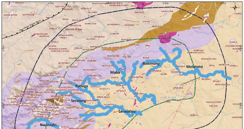
hardly places where a non-tested borehole cannot be found                  able yields, number of boreholes additional boreholes to
within a kilometre. However, GRIP results (GRIP Limpopo                    obtain yield, borehole depths, cost to drill, water quality, etc.
Online) suggest that as much as 75% of rural Limpopo can be            •   Well-field development cost, typically capturing borehole
supplied with potable water during a drought period by simply              development cost, including the borehole, pump, pump
repairing vandalised or dysfunctional boreholes (Botha, 2005).             house, rising main, command reservoir cost, etc.
    Why the lack of confidence in the available groundwater
figures? Certainly, one answer is that groundwater was the             General hydrogeology
‘new kid on the block’ and in the beginning there was large
variability in different groundwater figures and that created          Movement of the rock mass created highly fractured zones and
discomfort in groundwater development. According to the                may create favourable aquifer conditions. The ASTER images
NWRS (DWAF, 2004), the total available yield from ground-              show a long lateral lineament (ASTER Lineament – AL) in the
water resources in South Africa is estimated at about a 1 000          central to southern portion of the study area. During a field
Mm3/a. Based on Vegter’s (2001) estimation of current use              visit massive fracturing was observed and corresponded well
of groundwater due to the development of the modern drill-             with interpreted ASTER images. The most favourable places,
ing rig, the use should be around 3 600 Mm3/a, correspond-             however, were not in close proximity to towns and difficult to
ing well with the figure determined by Baron et al. (1996). If         link to any GRIP data.
Baron et al. and Vegter are correct in their assumptions, then              The contact between the granite and the gneiss is described
use exceeds the NWRS figure threefold. The different figures           as gradual and thus not much jointing within the contact zone
between use and yield create uncertainty. Confusing the issue          is expected. It was still investigated as a possible site for the
further was a groundwater exploitation potential assessment            development of aquifers. The granite is an intrusive rock and
study done by Haupt (2001) for the DWAF Directorate of Water           younger than the gneiss and at depth the gneiss rock mass is
Resource Planning, in which it was concluded that the exploit-         expected to have much higher hydrostatic pressure. Therefore
able groundwater available in South Africa could be as high as         at the current erosion surface the difference in stress might lead
19 000 Mm3/a.                                                          to slightly more fracturing (joints) in the gneiss compared to
    The Waterberg Aquifer at Lephalale is an excellent exam-           the granite. Higher weathering of the joints and more joints at
ple. If S (storativity) is estimated at 0.00022, then 0.7 Mm3 is       the contact may lead to more favourable aquifer conditions. It is
considered the minimum accessible volume of water if stor-             further speculated that boreholes should be placed just off the
age is utilised. However, if S is 0.005 then there is 400 Mm3          granite on the gneiss to drill through the gneiss into the granite.
in storage and 1.6 Mm3 per metre drawdown. This calculation            In areas north and north-west of Polokwane, Du Toit (2003) did
changes results completely and creates uncertainty within the          a study on the groundwater availability on the contact between
planning community (Botha et al., 2009).                               granites intrusions and Hout River Gneiss. He had great suc-
                                                                       cess and showed it to be good exploration sites. Du Toit’s study
Method and analysis                                                    was done in a geological setting where the granite intruded
                                                                       into the bedrock, whereas at the Nwamitwa Dam study area the
The Groundwater Resource Information Project (GRIP) was                granite mostly formed as a result of melting of the Goudplaats
developed with the aim of assisting in the gathering of ground-        Gneiss to form granite (CGS, 1987). The result thereof may
water data and to use it to improve assessment and management          be that the contact between that granite and gneiss may not
of groundwater resources within rural South Africa (Botha              be prominent. However, south of Giyani it was noted that the
et al., 2009). The project was initiated in Limpopo Province           contact is visible as biotite-rich pegmatitic material dipping
in 2002/2003 and is a continuous process of capturing and              slightly to the south (CGS, 1987). This pegmatite can create
verifying data. Similar GRIP projects are now underway in              favourable aquifer conditions. During a field visit and at some
KwaZulu-Natal, Eastern Cape, Free State and Mpumalanga                 places near Budzu the contacts showed fractured rock with
Provinces. The basic GRIP data show that a wealth of infor-            closely spaced jointing and were therefore identified as areas
mation is available if data are captured correctly; the database       with favourable aquifer conditions.
includes 15 500 boreholes and more than 6 000 constant dis-                 Both for linear structures and contacts between the gneiss
charge tests. Using the GRIP data, scientists for the first time       and granite most prominent jointing can be seen within major
had enough information to present groundwater at pre-feasibil-         drainage channels where rocks are exposed. The Badimong
ity level as a true bulk-water resource.                               and the Molototsi Rivers form topographical lows and were
                                                                       visited during a site visit. A combination of high-density joints
Requirements                                                           and prominent fractures exposed in the riverbeds and directly
                                                                       under well-sorted highly permeable sand creates favourable
The case study is situated within the service area of the              recharge conditions. Many joint sets visited are open and can
Nwamitwa Dam situated in Limpopo Province, some 150 km                 easily be targeted.
northeast of Polokwane. Although the dam was designed for                   Most towns, however, are located on topographical highs.
a firm yield of some 40 Mm3/a, more recent calculations sug-           As a result, most sites that are favourable for recharge are
gested a firm yield of approximately 14 Mm3/a. The water-              quite far away from villages. Furthermore, thick overburden
resource team, led by BKS, requested assistance from the               at villages makes it much more difficult to pinpoint joints and
GRIP team to develop a prefeasibility type report on the avail-        fracturing, even when using conventional geophysical methods.
ability of water. The final planning deliverables will therefore       Gneiss and/or granite weather to form low-permeable soils.
include the following:                                                 Also commonly found in these areas are ferricrete layers which
• A discussion with regards to sustainability of well fields           form impermeable subsurface layers within the top and mid-
     compared with surface water schemes                               dle areas of topographical heights, further reducing recharge
• A map showing proposed well fields within study area                 from the vadose zone into the aquifers. Poor land management
• Each well field should have a detail table capturing sustain-        and poor soil conditions around the villages result in limited

                                                                                                        http://dx.doi.org/10.4314/wsa.v38i3.4
                                                                                                  Available on website http://www.wrc.org.za
                              ISSN 0378-4738 (Print) = Water SA Vol. 38 No. 3 International Conference on Groundwater Special Edition 2012
392                         ISSN 1816-7950 (On-line) = Water SA Vol. 38 No. 3 International Conference on Groundwater Special Edition 2012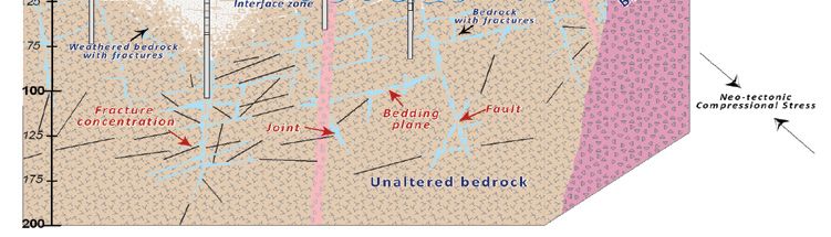
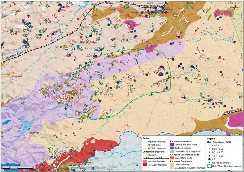
Figure 1
                                              Regional geology of the Nwamitwa case study

vegetation, and therefore there is no rainfall and runoff energy                                   Table 1
reduction by vegetative soil cover. It was observed that a zone               Determined hydrogeological parameter based on the
of wasteland was forming around each village.                                          geological setting of boreholes
                                                                           District      No. of BHs Unequipped No. of BHs      Equipped
                                                                                                      BH (rec.                  BH (rec.
Results and discussions                                                                             yield) (m3/d)                yield)
                                                                                                                                 (m3/d)
Despite the comprehensive and well-organised Groundwater                   Capricorn         978       104 029        902       90 738
Resource Information Project (GRIP) dataset, it remains unde-
rutilised amongst local and district municipalities throughout             Greater
                                                                                             652        55 958        752       46 566
the Limpopo Province. Boreholes drilled and tested within the              Sekhukhune
GRIP framework are often over-looked during water supply                   Mopani            589       40 947         995        65 525
projects and new boreholes are drilled without consideration               Vhembe            619        51 275        902       54 085
to the knowledge obtained from existing data. Tab;e 1 sum-                 Waterberg         556       52 846         374        26 433
marises all unequipped and equipped boreholes with recom-                  Total            3 394      305 055       3 925      283 348
mended yield (ℓ/s for 24 h). It must be noted that in most cases
the recommended yield is given for a single well and does not          •      The nature and depth of the regolith
take into account the cumulative effect of recommended yields          •      The development of fracture and fault zones
on the sustainability of the groundwater resource.                     •      The presence of higher porosity material (or adjacent
    In addition, only 33% of equipped boreholes produce water                 alluvium)
that is within acceptable drinking-water quality ranges (Class
I) which when combined give a total recommended abstraction            However, studies regarding the optimal location for high-
rate of 25 Mm3/a. A further 42 Mm3/a, with marginal to poor            yielding boreholes are rare and the siting of new boreholes is
quality drinking water (Class II and III), can be utilised with        often a wildcard drilling exercise with limited geophysical
prior treatment.                                                       support. The GRIP dataset, containing borehole productivity
                                                                       indicator data such as transmissivity, recommended borehole
Factors controlling borehole productivity                              yields, drawdown observed during pumping tests together with
                                                                       ASTER lineament interpretation, provides an opportunity
Independent or interrelated factors, such as geomorphology             to establish the most attractive drilling targets prior to water
(topography), lithology, brittle (neo-) tectonics, and surface         development projects.
water hydrology, all play a significant role in the occurrence of          The regional geology and the distribution of the GRIP bore-
groundwater in crystalline rocks, because together they control:       holes for the Nwamitwa Dam case study are provided in Fig. 1.

http://dx.doi.org/10.4314/wsa.v38i3.4
Available on website http://www.wrc.org.za
ISSN 0378-4738 (Print) = Water SA Vol. 38 No. 3 International Conference on Groundwater Special Edition 2012
ISSN 1816-7950 (On-line) = Water SA Vol. 38 No. 3 International Conference on Groundwater Special Edition 2012                        393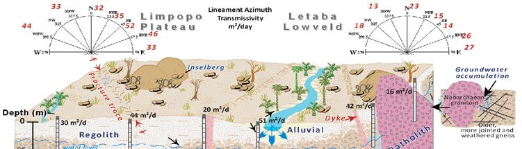
Figure 2
                                                                                                                      Conceptualisation
                                                                                                                       of transmissivity
                                                                                                                       values obtained
                                                                                                                         from various
                                                                                                                      borehole settings
                                                                                                                         (Holland and
                                                                                                                       Witthüser, 2011)

The geological information for each borehole was obtained              in the Limpopo basement lithologies is illustrated in Fig. 2.
from the published 1:250 000 geological maps. The identifica-          Based on the results it seems that higher borehole productivi-
tion of ‘alluvium’ boreholes was based on the published maps           ties are in fact associated with lineaments and dykes perpen-
as well as 100 m buffer zones along major river courses. There         dicular to the current stress regime, more specifically ENE to E
is a distinct variability in the transmissivities between the          and WNW to W. Due to the complex geological history of the
lithologies and geological setting of the focus area. The high-        area, it is difficult to link these open discontinuities to a distinct
est transmissivities were ‑ as expected ‑ observed in the pri-         recent or past tectonic event. The hydrogeological importance
mary alluvial aquifers, while the contact zones of the younger         of several factors on groundwater occurrence presented can
granite batholiths provide the highest transmissivities of the         be used as a working reference for groundwater development
basement rocks itself. The younger, large elongated leucogran-         programmes, in order to narrow down exploration targets to the
ites together with the main batholith bodies have the lowest           most influential factors.
transmissivities.
     The region has a high dyke and lineament frequency with           Hydrogeological targets
a strong NE trend (N45°E to N50°E), coinciding with the
regional Kudus River- and Tzaneen Lineaments (sub-parallel             The team used the geological and the GRIP information to
to the HRSZ). Higher transmissivities are associated with              identify areas that might have led to the development of high
lineaments striking ENE to E (N60°E to N90°E), representing            yielding aquifers. These areas include linear structures, gran-
an orientation oblique to the present-day NW-SE maximum                ite and gneiss contacts combined with enhanced aquifer condi-
horizontal stress. Based on the geological logs, boreholes which       tions within drainage areas. As a result several drainage chan-
encountered diabase or dolerite (dykes) have generally lower           nels where identified as potential areas to be reviewed (Fig. 3)
transmissivities and yields than boreholes devoid of diabase/
dolerite. Notably higher borehole productivities are observed          Detailed site assessment
within the 50 m to 150 m range compared to boreholes further
than 150 m. It can be generally accepted that lineaments have          A site-specific investigation was done for a site in the most
a positive influence on borehole productivity and should be            southern part of the service supply zone. This area is furthest
considered for future drilling programmes.                             from the proposed Nwamitwa Dam and from time to time is
     To determine the influence of drainage channels on the            likely to experience water shortages. Using the ASTER data
borehole productivity, a spatial assessment of proximity was           geological lineaments within close proximity to the Molototsi
conducted. Remarkably, 55% of all boreholes in the dataset are         River was sited. The potential lineaments were verified in
drilled within 150 m to streams or rivers as mapped on the             the field, followed by ground geophysics to pinpoint possible
1:50 000 topographic maps of South Africa. Nineteen percent            groundwater exploration sites. Some fractures were so profound
of these are along the major drainage channels with remarkably         that they were pinpointed using only geological interpretation.
enhanced transmissivities and yields. Drainage channels often              In total 22 boreholes were drilled with an average yield of
follow zones of structural weaknesses (e.g. lineaments) in the         3.3 ℓ/s/s with 9 boreholes having blow yields of 4 ℓ/s or more
near surface; therefore rocks in the vicinity of rivers can be         and only 2 dry boreholes. The average depth of the boreholes
more intensely fractured, jointed and/or weathered.                    was 120 m bgl (metres below ground level) and the average last
                                                                       water strike was at 80 m bgl, with the deepest water strike a
Conceptualisation                                                      deep 175 m bgl. Sustainable yields ranged between 0.3 ℓ/s and
                                                                       4.5 ℓ/s and the water quality was classified as Class 2, Class
The Limpopo basement lithologies can be characterised by a             3 and Class 4 (Table 2). Most of the borehole water samples
generally thin regolith where groundwater aquifers are primar-         showed total hardness (TH) and total dissolved solids (TDS)
ily structurally controlled. The current conceptual understand-        as being too high (Class 2) and it seems that cadmium (Cd) and
ing of the most significant features controlling borehole yields       arsenic (As) can also be somewhat elevated.

                                                                                                        http://dx.doi.org/10.4314/wsa.v38i3.4
                                                                                                  Available on website http://www.wrc.org.za
                              ISSN 0378-4738 (Print) = Water SA Vol. 38 No. 3 International Conference on Groundwater Special Edition 2012
394                         ISSN 1816-7950 (On-line) = Water SA Vol. 38 No. 3 International Conference on Groundwater Special Edition 2012
Figure 3
High yielding areas identified as possible well-fields
Table 2
Sustainable recommended yields and water quality summary
Borehole Constant Sustainable yield Water Quality Monitoring
No. test yield Rate Pump Volume Chemi Elements Bacteriological boreholes
(ℓ/s) (ℓ/s) cycle (m3/d) cal
H14-0786 Class 2 TH Class 2 – Total & faecal coliforms
H14-0786,
H14-0787 12.33 4.5 24 388.8 Class 2 As, Cd, TH
H14-0789
H14-0786,
H14-0789 12.55 4.5 24 388.8 Class 2 TH
H14-0787
H14-0790 2.20 0.8 24 69.12 Class 2 TH, As
H14-0960
H14-0968
H14-0981
H14-0986 None Class 2 Ec, TDS, TH, Na, Cl Class 2 – Total & faecal coliforms
H14-0999
H14-1000
H14-1001 None 0.3 12 12.96 Class 3 TH Class 3 – Total coliforms
H14-1002 5.28 1.7 24 146.9 Class 2 TH, As, Mn
H14-1347
H14-1698 0.9 0.2 24 17.28 Class 2 TH, EC, Na, F, Cl, As
H14-1699 3.01 1.0 24 86.4 Class 2 TH, EC, TDS, As, Na, Cl
H14-1700 None 0.1 3 54 Class 3 TH, EC, TDS, As, Na, F, Cl Class 4 – Total coliforms
H14-1701
H14-1702 10.1 1.8 24 155.5 Class 3 TH, EC, TDS, Cl
H14-1698,
H14-1703 16.19 4.5 24 388.8 Class 2 TH, As, EC, TDS, Na, Cl Class 3 – Total coliforms
H14-1699
http://dx.doi.org/10.4314/wsa.v38i3.4
Available on website http://www.wrc.org.za
ISSN 0378-4738 (Print) = Water SA Vol. 38 No. 3 International Conference on Groundwater Special Edition 2012
ISSN 1816-7950 (On-line) = Water SA Vol. 38 No. 3 International Conference on Groundwater Special Edition 2012 395Yield curve Yield curve
Well‐fields versus surface scheme Conjunctive scheme
25.00 40.00
20.00
30.00
Mm3/a
15.00
Mm3/a
10.00 20.00
5.00 Well fields Yield 10.00
0.00 Well fields Yield
2013 2014 2015 2016 2017 2018 2019 2020 2021 2022 2023 2024 0.00
2013 2014 2015 2016 2017 2018 2019 2020 2021 2022 2023 2024
Figure 4
Example of well-field yield compared with possible Figure 5
surface-scheme yield Combined yield curve for groundwater and surface water
Proposed Nwamitwa well-field development immediately generate revenues. Considering the world markets
and the unwillingness of banks to lend money for develop-
In total, 7 potential well-fields were identified (Fig. 3). The ment, it was decided to select a high interest rate of 20% and
well-fields are associated with fracturing; therefore recharge for the purpose of this study the price of water (income) was set
occurs both from rainfall recharge and river recharge, com- at R2/m3. The model shows that a capital investment of about
monly referred to as a losing river. Construction of a massive R380 million may be sufficient to develop well-fields which
in-channel storage dam is not required; water is simply stored will start to be self-sufficient in about 2018 and 2019.
underground rather than above ground. There is also less influ-
ence on natural flood events and more water available down- Development and operational strategy
stream for users.
A major advantage of groundwater is that it can be devel- Like all bulk resources it can either be developed by govern-
oped within close proximity to the user as can be seen in Fig. ment (DWA) or a semi-government organisation, for example
3. Another advantage is the rapid development of groundwater the Trans-Caledon Tunnel Authority (TCTA). A water board
resources. Given a period of 18 months for designs and EIAs or municipality can also develop and operate the groundwater
and 1 year for construction the first well-field could produce resources. They simply need to license the water use; it is a
potable water in early 2013. A number of drilling rigs can be social/political decision not discussed in this report.
deployed within the proposed well-field development zone and Installation of a modern telemetry data-management
within a 2-month period most boreholes can be drilled and system is recommended as it will ensure easy operation and
tested. The pipeline, balancing dams and command reservoir management, and to manage the well-field according to well-
have the longest lead items, but can also be completed within a field availability and water-demand requirements. These
1-year period. systems are used in the mining sector to ensure availability
Based on the exploration data, 3 production borehole yield of water supply and some municipalities in the Western Cape
types were selected (1.5 ℓ/s, 3 ℓ/s and 4.5 ℓ/s) and lengths of the also use these systems to manage their water supply. The great
proposed well-fields were estimated. To ensure that localised advantage is that water levels, volume, electricity consumption,
dewatering does not occur, it was decided to keep boreholes etc., are all recorded and an alarm is triggered if it runs outside
500 m apart. Individual boreholes were selected to achieve a set parameters.
borehole density of higher than 500 m between boreholes and
boreholes with yields of 4.5 ℓ/s were limited to a distance of Conclusions and recommendations
1 300 m. Estimated borehole yields from each borehole were
added up to estimate well-field yields. Proposed well-field Within the South African context, groundwater has not been
yields varied between 2.6 Mm3/a and 4.2 Mm3/a. used at this scale to develop a rural bulk-water scheme and the
In addition, well-fields can be constructed in a consecutive real costs and benefits were never tested in a scheme. The GRIP
manner or as the need arises; for this study it is shown as con- dataset makes it possible for the user to apply it and gives deci-
secutive development. Compared to surface water resources, sion-makers a glimpse of what may be it South Africa take a bold
capital expenditure almost immediately results in available step forward and develop groundwater as a bulk-water resource.
water supply (Fig. 4). Further to this, conventional storage The GRIP dataset was used to accurately describe the hydrogeo-
schemes capture water from 1 catchment only whereas well- logical conditions within the sturdy area and to show that it is
fields can access more catchments and cumulatively harvest possible to find high-yielding boreholes within the area.
more water. A site-specific investigation demonstrated that it is possible
The overarching aim is to illustrate the value of conjunctive to locate new high-yielding boreholes and chemical and bacte-
use and therefore short- to medium-term solutions provided by riological data show all boreholes to be Class 2, 3 or 4 and raw
groundwater need to be combined with surface-water solutions water is not suitable for domestic supply. As a result of these
to provide the optimum solution, where groundwater resources findings and pending additional long-term borehole tests and
can be developed first, followed by a surface-water resource subsequent chemical analyses of high-yielding boreholes, the
(Fig. 5). costs to treat the water to potable standards may still have to be
added to the development costs.
Well-field development cost Preliminary results, however, show that well-fields can
be rapidly developed at R2/m3 and requires capital input of
Based on phased implementation, the model was created to roughly R380 million over a period of 7 years to 8 years. In
better estimate groundwater development cost. Using mini- addition, well-fields should be managed like any other bulk-
mum capital cost, groundwater can be developed and can water resource and a telemetry data-management system
http://dx.doi.org/10.4314/wsa.v38i3.4
Available on website http://www.wrc.org.za
ISSN 0378-4738 (Print) = Water SA Vol. 38 No. 3 International Conference on Groundwater Special Edition 2012
396 ISSN 1816-7950 (On-line) = Water SA Vol. 38 No. 3 International Conference on Groundwater Special Edition 2012should be used to improve operation thereof. Typically a water DWA (DEPARTMENT OF WATER AFFAIRS, SOUTH AFRICA)
board or municipality should take responsibility for a well-field (2009) Strategic Planning for Water Resources in South Africa,
and manage it in a sustainable manner. Situation Analysis. Department of Water Affairs, Pretoria, South
Africa.
DU TOIT WH (2003) The Influence of Granite Intrusions on the Host
References Rocks in Terms of Occurrence of Groundwater in the Pietersburg
Area. M. Tech. Thesis. Faculty of Natural Sciences, Technikon
BARON J, SEWARD P and SEYMOUR A (1996) The Groundwater Pretoria, South Africa.
Harvest Potential Map of the Republic of South Africa. DWAF GRIP LIMPOPO (2002) Limpopo Groundwater Resource Information
Report No. Gh3917. Department of Water Affairs and Forestry, Project (GRIP) - An initiative of the Department of Water Affairs
Pretoria, South Africa. (DWA) to collate groundwater information and establish a ground-
BOTHA FS (2005) A Proposed Method to Implement a Groundwater water information system for the Limpopo Province. Online v.2.0.
Resource Information Project (GRIP) in Rural Communities, South URL: http://griplimpopo.co.za/login.php (Accessed 25 November
Africa. Ph.D. Thesis. University of the Free State, Bloemfontein, 2010).
South Africa. HAUPT CJ (2001) Ground Water Resources of South Africa. WSM
BOTHA FS, VELTMAN S, WEIDEMANN R and FOURIE F (2009) Report for Directorate of Water Resource Planning. DWAF
Aquifer boundaries versus economic development, Lephalale, Report No. 97128, April edition. Department of Water Affairs and
South Africa. Proc. Groundwater 2009 Conference. 16-18 Forestry, Pretoria, South Africa.
November 2009, Cape Town, South Africa. HOLLAND M and WITTHÜSER KT (2011) Evaluation of geologic
COUNCIL FOR GEOSCIENCE (CGS) (1987) Explanation Sheet 2330 and geomorphologic influences on borehole productivity in
(1:250 000). Council for Geoscience, Pretoria, South Africa. crystalline bedrock aquifers of Limpopo Province, South Africa.
DWAF (DEPARTMENT OF WATER AFFAIRS AND FORESTRY, Hydrogeol. J. 19 1065-1083. DOI: 10.1007/s10040-011-0730-5.
SOUTH AFRICA) (2004) National Water Resource Strategy RSA (REPUBLIC OF SOUTH AFRICA) (1998) National Water Act.
(1st edn.). Department of Water Affairs and Forestry, Pretoria, Act No. 36 of 1998. Republic of South Africa. Government Gazette
South Africa. No. 19182.
DWAF (DEPARTMENT OF WATER AFFAIRS AND FORESTRY, VEGTER JR (2001) Groundwater Development in South Africa and
SOUTH AFRICA) (2007) Artificial Recharge Strategy. Version 1.3 an Introduction to the Hydrogeology of the Groundwater Regions.
– June 2007. Department of Water Affairs and Forestry, Pretoria, WRC Report No. TT 134/00. Water Research Commission,
South Africa. Pretoria, South Africa.
http://dx.doi.org/10.4314/wsa.v38i3.4
Available on website http://www.wrc.org.za
ISSN 0378-4738 (Print) = Water SA Vol. 38 No. 3 International Conference on Groundwater Special Edition 2012
ISSN 1816-7950 (On-line) = Water SA Vol. 38 No. 3 International Conference on Groundwater Special Edition 2012 397http://dx.doi.org/10.4314/wsa.v38i3.4
Available on website http://www.wrc.org.za
ISSN 0378-4738 (Print) = Water SA Vol. 38 No. 3 International Conference on Groundwater Special Edition 2012
398 ISSN 1816-7950 (On-line) = Water SA Vol. 38 No. 3 International Conference on Groundwater Special Edition 2012You can also read


