COVEY CREEK WMPA 2022-2026 - MASTER WILDLIFE MANAGEMENT PLAN WILLIAMSON COUNTY - Covey Creek Preserve
←
→
Page content transcription
If your browser does not render page correctly, please read the page content below
2022-2026
MASTER WILDLIFE MANAGEMENT PLAN

      COVEY CREEK WMPA
         ANDICE 230, LLC

      WILLIAMSON COUNTY

        PREPARED BY WILDLIFE BIOLOGIST
             JAMES HALL, CWB
COVEY CREEK WILDLIFE MANAGEMENT PROPERTY ASSOCIATION
                                   ANDICE 230, LLC
                      WILDLIFE MANAGEMENT PLAN FOR 2022-2026
                     SITE VISIT CONDUCTED ON NOVEMBER 18, 2021
                                      SUMMARY

PROPERTY DESCRIPTION:
   Covey Creek is a ± 229.710 acre Wildlife Management Property Association (WMPA) located in
   northwest Williamson County off of County Road 251, approximately 13 miles northwest of
   Georgetown, TX. See attachment for specific Williamson CAD account numbers.

CURRENT AND PLANNED USE:
   The 229.710 acre property is currently under wildlife management for active recreational use and
   passive aesthetic enjoyment; to be valued under 1-d-1w wildlife management use appraisal. A WMPA
   has been formed to allow a multi-lot wildlife management subdivision. As lots are sold, individual
   wildlife plans will be prepared for each owner ensuring compliance and proper guidance by Plateau
   Land & Wildlife Management. See attached Declaration of Restrictions, Covenants, and Easements.

TARGET INDIGENOUS SPECIES:
   Songbirds
   Mourning Dove
   Wild Turkey
   Northern Bobwhite
   Small Mammals

POTENTIAL M ANAGEMENT PRACTICES FACILITATED BY WMPA:

   SUPPLEMENTAL WATER
              1. Well/Troughs/Windmill Overflow/Other Wildlife Watering Devices 2022-2026
   SUPPLEMENTAL FOOD
              1. Feeders and Mineral Supplementation 2022-2026
   SUPPLEMENTAL SHELTER
              1. Nest Boxes, Bat Boxes 2022-2026
   M AKING CENSUS COUNTS TO DETERMINE POPULATION
              1. Songbird Transects and Counts 2022-2026

SUGGESTED M ANAGEMENT PRACTICES FOR INDIVIDUAL LANDOWNERS:

   HABITAT CONTROL
              1. Brush Management 2022-2026
   EROSION CONTROL
              2. Pond Construction and Major Repair 2022-2031
   PREDATOR CONTROL
                 Predator Management 2022-2026
              1. Imported Red Fire Ant Control 2022-2026
   SUPPLEMENTAL SHELTER
              1. Brush Piles and Slash Retention 2022-2026
              2. Hay Meadow, Pasture and Cropland Mgmt. for Wildlife 2022-2026
   M AKING CENSUS COUNTS TO DETERMINE POPULATION
              1. Census and Monitoring of Non-game Wildlife 2022-2026

                                                 3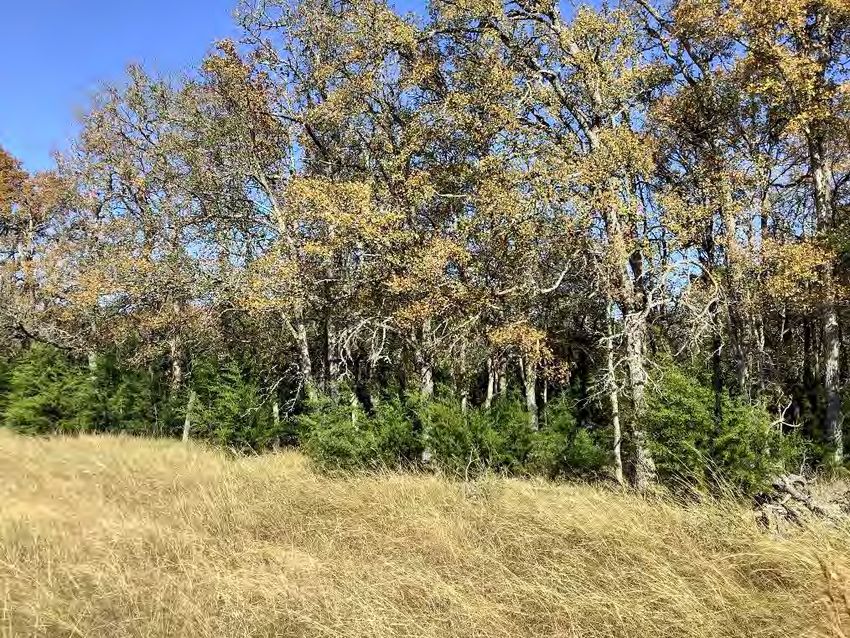
COVEY CREEK WILDLIFE MANAGEMENT PROPERTY ASSOCIATION
                                  ANDICE 230, LLC
                     WILDLIFE MANAGEMENT PLAN FOR 2022-2026
                    SITE VISIT CONDUCTED ON NOVEMBER 18, 2021

PROPERTY DESCRIPTION

    Size                                +/- 229.710 acres
    Location                            Northwest Williamson County
    Nearest Town/Major                  13 miles northwest of Georgetown, TX off of County Road
    Intersection                        251
    Shape                               Irregular
    Boundary Features                   Surrounded by private lands with CR 251 forming the
                                        western boundary
    Significant Water Features          South Berry Creek meanders through the property, with a
                                        small spring-fed pool, and small ponds
    Terrain                             Rolling topography throughout with a general decline towards
                                        the central creek and gradually to the east
    Elevation                           Maximum - 970 ft. MSL
                                        Minimum - 920 ft. MSL
    Fencing                             Perimeter and internal low-fencing
    Wildlife Use Appraisal Region       Eastern Edwards Plateau
    Ecological Region                   Cross Timbers and Prairies
    River Sub-Basin                     San Gabriel
    Major River Basin                   Brazos River
    Coastal Bay                         Gulf of Mexico
    Average Rainfall for Area           32-34 inches/yr.

CURRENT HABITAT DESCRIPTION
   Covey Creek consists of two major habitat types:

   1. Open Juniper-Oak Woodland- 123.03 acres
   2. Grassland – 106.68 acres

 OPEN JUNIPER-OAK WOODLAND
   WHERE IT OCCURS:
   Primarily in the northwestern section, in the south-central area, and scattered throughout the
   eastern area.

   CANOPY LAYER:
   The canopy ranges from 50-90%, consisting mostly of Ashe juniper, with large pockets of live oak
   and cedar elm. The occasional hackberry, Texas oak, and post oak can be found.

   SHRUB LAYER:
   The understory contains a variety brush species typical of the area, with young junipers being
   prevalent. Prickly pear, persimmon, elbowbush, yucca, bumelia, and greenbriar are also noted
   throughout.

                                                  4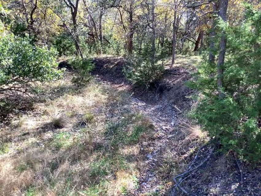
HERBACEOUS LAYER:
   In shady areas, cedar sedge, wildrye, and frostweed are common along with other shade-tolerant
   plants. Open pockets and sunny margins contain a mix of native and non-native bunchgrasses with
   a variety of interspersed weedy forbs and wildflowers.

   M ANAGEMENT PRIORITIES:
   While woody plants provide forage and cover for wildlife, young junipers have the tendency to
   invade and become overabundant particularly beneath hardwood canopies. Fire ants are non-
   native predators that reduce native insect populations and prey on nesting songbirds, small
   mammals, and other wildlife. Controlling fire ants should be conducted annually via individual
   mound treatments. Installing nest boxes for cavity-nesting songbirds would encourage their
   presence and propagation on site. Providing sources of supplemental water would benefit all
   wildlife, and free-choice feeders should also be considered to supplement natural food sources,
   especially for quail, turkey, songbirds, and dove.

   PLANTS OBSERVED:
                 TREES                 SHRUBS/VINES/SUCCULENTS                GRASSES/FORBS
      Live oak                        Persimmon                       Virginia wildrye
      Cedar elm                       Agarita                         Cedar sedge
      Ashe juniper                    Ashe juniper                    Frostweed
      Texas oak                       Mesquite                        Scribner’s rosettegrass
      Post oak                        Elbowbush                       Little bluestem
      Hackberry                       Gum bumelia                     King Ranch bluestem
                                      Prickly pear cactus             Yellow indiangrass
                                      Twist-leaf yucca                Purple threeawn
                                      Greenbriar                      Texas wintergrass
                                                                      Broomweed
                                                                      One-seed croton

Cedar elm and live oak are prominent on site, forming a healthy, elevated canopy in woodland areas.

                                                 5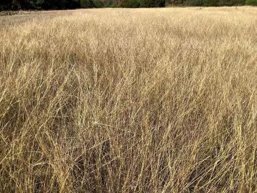
Small drainage corridor that meanders through the woods in the NW, feeding into South Berry Creek.

        Another drainage corridor lined by elms, with a dense understory of young junipers.

                                                6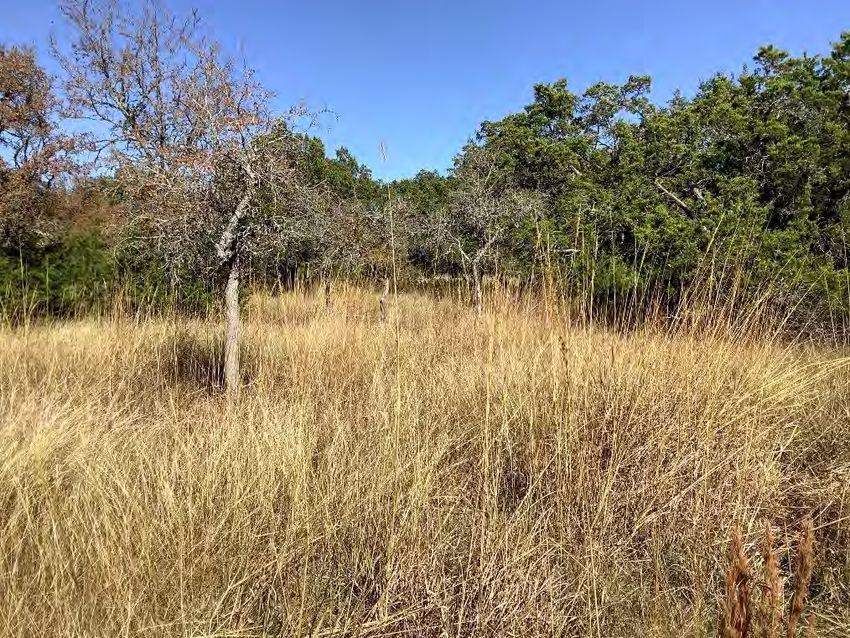
Sunny meadow dominated by native indiangrass and little bluestem.

View of the creek, which has recently been cleared of overabundant junipers.

                                     7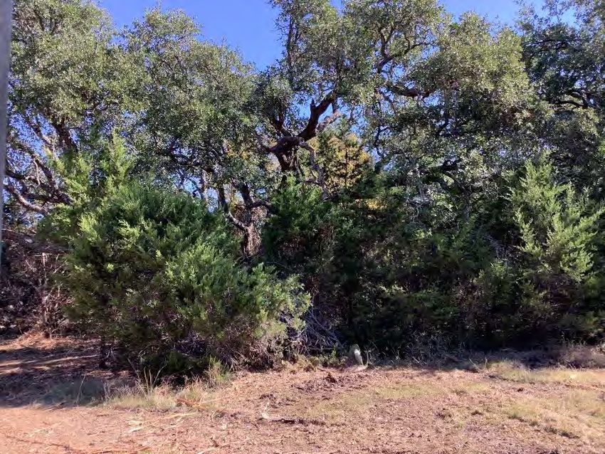
GRASSLAND
 WHERE IT OCCURS:
 Throughout the property in scattered areas. The largest open grassland occurs in the far
 southwestern corner extending to the center.

 CANOPY LAYER:
 Canopy in these areas varies with the occasional large oak or elm.

 SHRUB LAYER:
 Juniper once again is common throughout in mostly its young to mid-aged stage. Prickly pear
 cactus, yucca, elm, greenbriar and other shrubs can be found sporadically.

 HERBACEOUS LAYER:
 In most of the open fields, non-native King Ranch bluestem dominates the ground cover. Higher
 quality little bluestem, indiangrass, sideoats grama, and other native grasses can be found as well
 in a lower abundance.

 M ANAGEMENT PRIORITIES:
 Cool-season strip mowing may help encourage grass and cover diversity. Selective juniper
 management should be considered in some areas, along with nest box placement, fire ant control,
 and sources of supplemental food and water.

 PLANTS OBSERVED:
               TREES                  SHRUBS/VINES/SUCCULENTS                 GRASSES/FORBS
    Ashe juniper                     Ashe juniper                     King Ranch bluestem
    Live oak                         Gum bumelia                      Little bluestem
    Cedar elm                        Lime prickly ash                 Silver bluestem
                                     Prickly pear cactus              Tall grama
                                     Twist-leaf yucca                 Sideoats grama
                                     Persimmon                        Purple threeawn
                                     Agarita                          Windmillgrass
                                                                      Slim tridens
                                                                      Yellow indiangrass
                                                                      Brownseed paspalum
                                                                      Broomweed
                                                                      Silver-leaf nightshade
                                                                      Purple eryngo
                                                                      Texas thistle
                                                                      Wild millet
                                                                      One-seed croton
                                                                      Gayfeather
                                                                      Bastard cabbage
                                                                      Maximillian sunflower
                                                                      Gayfeather
                                                                      Western ragweed

                                               8
Open field with scattered juniper cover, and containing mostly King Ranch bluestem.

               Another field enveloped by young woodland habitat.

                                        9
Mixed grassland / savannah habitat.

Up-close view of dense King Ranch bluestem, the non-native variety that is typically viewed as too dense
                                  for many native wildlife species.

                                                  10
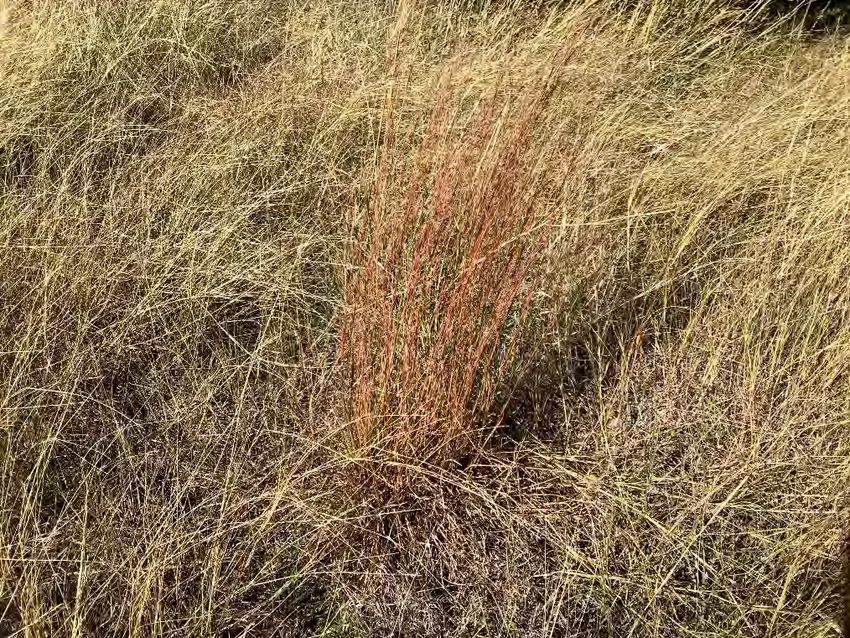
Single stand of high-quality native bunchgrass, known as little bluestem.

   M ANAGEMENT PRIORITIES:
   In open grassland habitat, construction of brush piles will prove to be very beneficial for small
   critters, including small mammals, songbirds (especially during winter months), and quail. Cool-
   season strip mowing focusing on pure stands of King Ranch bluestem will encourage more diversity
   in the composition and structure of open habitat. Fire ants are more common in open grassy areas,
   rather than woodlands.

ADDITIONAL NOTES / OBSERVATIONS
   At least three wildlife management activities in unique categories need to be performed each year
   to qualify. To adequately maintain your wildlife valuation, it is important to document all of your
   management activities throughout the year. This includes taking photographs during the completion
   of your activities, retaining receipts and logsheets, and being able to indicate the location of these
   items on a map of your property. The Williamson Central Appraisal District may request an Annual
   Report at the end of each year, and site inspections are also possible, so being complete and
   organized with your documentation will ensure good standing with the county.

   Based on observed browsing of woody plants, including greenbriar and elm, a lack of hardwood
   recruitment (specifically Texas red oak), deer numbers are likely moderate to high, as typical in the
   area. While deer are not a target species of this wildlife management plan and hunting is not a
   formal component of this plan, discouraging deer numbers is encouraged as it will increase the
   abundance and diversity of seed-producing forbs (an important food source for a variety of seed
   eaters), encourage recruitment of important shrubs and trees (important cover and food sources for
   a variety of birds and mammals), and increase amounts of available forage for all wildlife. The use
   of year-round corn feeders on properties where no hunting will occur is discouraged, especially if
   feral hogs are present.

                                                 11
SOIL TYPES (FROM NRCS SOIL DESCRIPTIONS)
There are seven main soil types located on the Andice 230, LLC property in Williamson County.
Map unit: CfB - Crawford clay, 1 to 3 percent slopes
The Crawford component makes up 100 percent of the map unit. Slopes are 1 to 3 percent. This
component is on plains on plateaus. This component is in the Deep Redland ecological site. Nearly
level to gently sloping upland of reddish brown, moderately deep, non-calcareous clays, clay loams,
or loams. Climax plants are predominantly yellow indiangrass, little bluestem, big bluestem,
sideoats grama, feathery bluestems, Texas wintergrass, tall dropseeds, oaks, and many good
forbs.
Map unit: DnB - Denton silty clay, 1 to 3 percent slopes
The Denton component makes up 100 percent of the map unit. Slopes are 1 to 3 percent. This
component is on ridges on hills. This component is in the Clay Loam ecological site. Nearly level to
rolling uplands of clayey soils. Climax plants are predominantly little bluestem with yellow
indiangrass, big bluestem, switchgrass, vine-mesquite, sideoats grama, elm, live oak, hackberry,
and many forbs such as Maximilian sunflower, Engelmann’s daisy, bush sunflower, and half shrub
sundrop.
Map unit: DoC - Doss silty clay, 1 to 5 percent slopes
The Doss component makes up 100 percent of the map unit. Slopes are 1 to 5 percent. This
component is on plains on plateaus. This component is in the Shallow ecological site. Shallow,
clayey soils. Climax vegetation is big and little bluestems, yellow indiangrass, sideoats and tall
gramas, cane bluestem, plains lovegrass, Maximilian sunflower, bush sunflower, Engelmann’s
daisy, orange zexmenia, daleas, gayfeather, sundrops, penstemon, heath aster, prairie clover,
prairie bluets, and bundleflower, with scattered live oak.
Map unit: EaD - Eckrant cobbly clay, 1 to 8 percent slopes
The Eckrant component makes up 100 percent of the map unit. Slopes are 1 to 8 percent. This
component is on ridges on plateaus. This component is in the Low Stony Hill ecological site. Very
shallow, stony, clay soils. Climax vegetation is live oak, shin oak, sumac, kidneywood, with little
bluestem, yellow indiangrass, sideoats grama, fall witchgrass, wildrye, sprangletop, orange
zexmenia, sagewort, dalea, woollywhite, bush sunflower, snoutbean, sundrop, and Engelmann’s
daisy.
Map unit: FaB - Fairlie clay, 1 to 2 percent slopes
The Fairlie component makes up 100 percent of the map unit. Slopes are 1 to 2 percent. This
component is on ridges on plains. This component is in the Blackland ecological site. Deep, fertile,
clay soils. Climax vegetation is little bluestem, big bluestem, yellow indiangrass, and switchgrass,
with Maximilian sunflower, Engelmann’s daisy, button snakeroot, bundleflowers, prairie clover,
prairie parsley, Indian plantain, and gayfeather. Live oak may dot the landscape.
Map unit: GsB - Georgetown stony clay loam, 1 to 3 percent slopes
The Georgetown component makes up 100 percent of the map unit. Slopes are 1 to 3 percent. This
component is on plains on plateaus. This component is in the Redland ecological site. Stony,
shallow, reddish, non-calcareous loams. Climax vegetation includes little and big bluestems, yellow
indiangrass, sideoats grama, tall dropseed, Texas wintergrass, vine-mesquite, wildrye, Texas
cupgrass, buffalograss, curly mesquite, Engelmann’s daisy, bush sunflower, asters, sagewort; live,
post, and shin oaks, sumacs, elm, bumelia, greenbriar, and elbowbush.
Map unit: Tn - Tinn clay, frequently flooded
The Tinn component makes up 95 percent of the map unit. Slopes are 0 to 1 percent. This
component is on circular gilgai on flood plains on plains. This component is in the Clayey
Bottomland ecological site. Deep, clay, bottomland soils supporting a savannah of oak, elm,
12hackberry, and ash, with understory of grape, greenbriar, honeysuckle, and hawthorn. Virginia
wildrye, switchgrass, eastern gamagrass, and beaked panicum occur with blood ragweed,
ironweed, white crownbeard, and spiny aster are also present.
PAST HISTORY OF LAND USE AND WILDLIFE
The Andice 230, LLC property has historically been used for wildlife management and is valued
under 1-d-1w open space valuation. The abundance of wildlife currently on the property provides
both passive and aesthetic enjoyment for the landowners’ family and friends.
LANDOWNER GOALS
The landowners intend to manage this land to the benefit of native wildlife and sustaining habitat
including restoration to healthy community associations of Cross Timbers and Prairies woody and
grassland species.
The Covey Creek WMPA intends to assist and guide future landowners within the subdivision with
the help of Plateau Land and Wildlife Management, to restore and manage this land for increased
biodiversity for the passive and aesthetic enjoyment afforded by the property. This healthy habitat
will be managed primarily for the benefit of songbirds, small mammals, Mourning Dove and ground-
nesting birds such as Wild Turkey and Northern Bobwhite. While the target species of this plan are
restricted to the above species, activities performed will benefit a wide variety of wildlife in addition
to improving overall land health and ecological function. Because different portions of the property
are suitable for different types of wildlife, actively managing for multiple species concurrently is
consistent with wildlife management principles and will maximize overall benefit to wildlife.
MASTER WILDLIFE MANAGEMENT PLAN
Preparation and implementation of this Master Plan wildlife management plan involves enumerating
the target species, planned practices, and monitoring methods. This plan was prepared by James
Hall, CWB, wildlife biologist, of Plateau Land and Wildlife Management, Inc. The site visit to gather
information used for this plan was conducted on November 18, 2021.
PLANNED WILDLIFE MANAGEMENT PRACTICES
HABITAT CONTROL
1. Brush Management. (2022-2026) Brush management is an effective tool for controlling
encroachment of regrowth Ashe juniper (or “cedar”) and fostering the production of desirable trees,
shrubs, grasses, and forbs, which promotes forage, nesting, and/or protective cover for native
wildlife species.
Best practices for controlling excess brush and mitigating risk of reinvasion include:
Assessing soil types, slope angle and direction to minimize soil loss and erosion
Targeting juniper in its early growth stage with hand loppers and/or chainsaws
Removing juniper shorter than 8 feet and with a main trunk diameter that measures 6 inches
or less at breast height
Limiting the removal of large mature juniper with shredding bark, which is important nesting
material for declining songbirds
Not all cedar needs to be removed, but they can be taken selectively in a mosaic and well-
planned fashion, ensuring some evergreen cover still exists on site
13Dense lower limbs can also be pruned, being careful not too overly modify or
“park-up” the habitat
Some standalone cedar can be retained or selectively thinned, retaining at least some wildlife cover, and
privacy for lot owners along property lines.
Understory junipers established beneath hardwoods can be prioritized for removal.
14Example photo from another property, exhibiting what high-intensity pruning can look
like along a healthy creek corridor.
Future Individual Lot Owners – For landowners who choose to conduct this activity, brush
management must affect a minimum of 10% of the designated brush management area on their
property or 10 acres (whichever is smaller) annually. For example, if the designated area is 10
acres, then a minimum of 1 acre of brush management must be conducted in order to qualify.
Brush management conducted solely for house or road construction does not qualify. Brush
management should not conflict with any of the restrictions provided by the WMPA. Photo
records, including before and after pictures, as well as maps of designated and treated
areas should be maintained and available on request.
EROSION CONTROL
1. Pond Construction and Major Repair. (2022-2031) Landowners may choose to construct a
permanent water pond to control and prevent erosion, which will also promote habitat diversity and
other wildlife benefits. Where possible, the landowner will create shallow water areas as primary
production wetlands, which will aid in the production of wetland plants and provide valuable habitat
for aquatic invertebrates. The Pond Construction Area is designated on the attached map. Upon
completion, this activity will qualify for 10 years of credit, as long as annual monitoring and
maintenance are performed. The landowner will maintain annual documentation to include photos,
invoices, a map of the pond location, and other associated records that can be made available to
the county upon request.
Future Individual Lot Owners – For landowners who choose to conduct this activity, damming up
Warren Creek is not allowed without specific permission by the WMPA, and may require additional
permits. Small ponds can be constructed along draws and drainages that feed into the creek.
Photo records, including before and after pictures, and location of the pond should be
maintained and available on request.
15PREDATOR CONTROL
1. Predator Management. (2022-2026) Individual landowners will trap and/or hunting feral hogs. Feral
hogs pose a great threat to native wildlife and land health in Williamson County. Omnivorous hogs
kill small mammals and ground nesting birds, consume large amounts of vegetation, and contribute
to the spread of invasive, non-native vegetation. Hogs also compete with native species for food
and water resources, and their rooting and wallowing activities can cause significant erosion and
degradation of riparian areas.
The landowners’ primary means of hog control will be hunting, but live trapping in baited areas can
be considered. This is most effective during the late winter-early spring months, when forage is less
abundant and hogs are more likely to be tempted by bait. Pre-baiting will allow hogs to become
accustomed to entering traps, thereby increasing the efficacy.
Corral traps are effective for trapping large numbers of hogs. Box traps and snares may be more
feasible in some areas or for smaller numbers of hogs. Hogs sighted incidentally on the property
will be shot. Ideally, hunting and trapping pressure will occur in spring and early summer when
hogs are the greatest threat to the reproductive activities of other wildlife.
Additional information on controlling feral hog populations is available at http://feralhogs.tamu.edu/.
The landowners will maintain annual documentation, to include records of feral hogs trapped and/or
killed, records of trap-days run per year, photos, and map of trap location(s) that can be made
available to the county upon request.
Raccoons and skunks may also be controlled as needed to reduce predation on target species.
These native, opportunistic predators are a natural part of the ecosystem. In some cases, however,
they can greatly overpopulate if dependable water and food sources (e.g., feeders) are accessible
to them, and they can pose a significant threat to native wildlife populations, such as quail, turkey,
and other ground-nesting birds. Hunting / opportunistic shooting and trapping may both be
considered. Baited live-traps should be placed near known concentrations of the varmints as often
as possible, primarily in spring and early summer months. Trapped animals should be dispatched
instead of relocating to another property; however, relocating may occur if the landowner has
obtained prior authorization from TPWD and the landowner of the property on which the animal is
being released.
The landowners will record and evaluate incidental sightings of skunks and raccoons annually to
determine when to scale back control measures. The landowners will maintain annual
documentation, to include predator harvest/trapping logs, photos, map of trap location(s) (if
applicable), and other associated monitoring records that can be made available to the county upon
request
2. Imported Red Fire Ant (IRFA) Control. (2022-2026) The landowners will develop and execute a
predator management plan to reduce the presence of Imported Red Fire Ants (IRFA), which are
known to occur and have caused problems on the property. Imported fire ants negatively affect
wildlife populations through consumption of food sources that would otherwise be available for
native wildlife, as well as by the direct predation of bird nestlings and other species.
The landowner will annually monitor (fall or spring) and treat infested areas with non-toxic products,
such as growth inhibiting, metabolic modifying, or hormone interrupting baits, as much as possible.
Extinguish Plus is recommended as an effective fire ant control bait for use on areas that will not be
grazed by beef cattle or other livestock. Extinguish or similarly approved product may be used for
areas grazed by livestock raised for human consumption. The bait should be applied at the rate of 2
to 5 tbsp. per mound or according to label directions. A combination of spring and fall mound
applications produce the greatest effect.
Future Individual Lot Owners – 10 acres of annual fire ant monitoring and treatment is sufficient on
each property. Native ants, such as leaf-cutter ants, harvester ants, etc., should NOT be
treated and, where needed, protected from treatment as they provide competition for imported red
fire ants and serve a valuable purpose within the native range. Landowner will monitor and treat a
minimum of 10 acres annually. Annual documentation will be maintained, to include photos, map of
16treated area(s), product invoices, and other associated monitoring records that can be made
available to the county upon request.
Typical fire ant mound.
Up-close view of native harvester ants at the entrance to their mound, typically flat and consisting of a
circle of bare ground.
SUPPLEMENTAL WATER
1. Well/Trough/Windmill Overflow/Other Wildlife Watering Devices. (2022-2026) WMPA Activity.
Water is an essential component to a healthy habitat. The landowner will provide at least 1 source
of supplemental water for the propagation of wildlife through either a trough, guzzler, pan, and/or
17other watering device. The watering device will be fed from a rainwater collection system or through
well water and will be supplemented during dry periods to promote year-round availability.
Texas Parks and Wildlife guidelines highlight the importance of protecting small animals from
drowning while using the watering device. Drowning can easily be averted by constructing a simple
ramp of rocks, wire, lumber, or other material on the internal and external sides of each watering
device, allowing safe access and escape for all wildlife species. Ideal placement of supplemental
water includes areas that are lacking a pond, creek, river, or other natural water source, and in
which water is typically lacking, such as dry upland areas.
The landowner will retain applicable annual documentation, such as activity location, dates, photos,
receipts, and other records of work performed, that can be made available to the county upon
request.
Example stock photo of Plateau’s rainwater collection system that can provide a year-round source of
water for wildlife.
Future Individual Lot Owners – Access to the creek will be available for all lots, and thus water is
not a critical limiting factor on the Covey Creek WMPA. However, providing a small wildlife water
source, such as a Plateau Water Table (pictured above) is well-suited to benefit target species and
improve waters distribution across the ranch as a whole. This is a simple and easily maintained
activity.
PROVIDING SUPPLEMENTAL SUPPLIES OF FOOD
1. Feeders and Mineral Supplementation. (2022-2026) WMPA Activity. Reliable food resources are
essential for wildlife. While a healthy and diverse habitat provides natural sources of food,
supplying supplemental sources can encourage wildlife survival and propagation, particularly during
breeding seasons and periods of harsh weather. The current Andice 230 acreage will require at
least one large feeder to maintain compliance prior to subdivision / sale of lots. Future landowners
may also maintain 1 large feeder or 3-4 small hanging feeders for songbirds, dove, turkey, and
quail, in accordance with Texas Parks and Wildlife guidelines, which require that feeders be free
18choice. The landowner will fill each feeder with a mixture of scratch grains, wild birdseed, and/or
sunflower seeds. Best practices for feeders include:
Place feeders outside the vicinity of residential acreage
Use feeders that are designed to deter access by non-target species, such as raccoons, deer,
and feral hogs
Clean and fill feeders regularly
Provide a minimum of 25% sunflower seeds to promote a heathy protein and fat content,
especially during the winter months when fat reserves are vital
Avoid providing only corn, which lacks nutritional value needed by songbirds and does not
qualify as a supplemental food source.
Avoid spin-cast, timed feeders as they do not satisfy TPWD requirements for this wildlife
management activity
The landowner will maintain annual documentation to include feed receipts, dates of filling and
maintenance, photos, and map of feeder location(s) that can be made available to the county upon
request.
Example stock photo of Plateau’s large platform feeder designed for songbirds, Wild Turkey, quail, and
dove, while excluding non-target species like deer, hogs, and raccoons.
19Example stock photo of Plateau’s large ground feeder. This feeder is also suitable for small acreage lots,
but is less effective at excluding non-target/nuisance wildlife.
Example stock photo of Plateau’s hanging bird feeder.
Future Individual Lot Owners – This is a simple activity that easily applies to any resident
landowner, but may be applied by the WMPA. Songbird feeders (placed outside any residential
areas) will qualify for each property on which they occur. A variety of feeders are suitable during
different seasons. 1 large or 3-4 small hanging is sufficient for supplemental food on each lot /
property.
20PROVIDING SHELTERS
1. Nest Boxes, Bat Boxes. (2022-2026) WMPA Activity. Providing supplemental shelter for cavity-
nesting wildlife promotes nesting success when natural cavities are scarce. For the current property
as a whole (238 acres), at least 40 nests boxes are needed to qualify.
Eastern Bluebird nest boxes to be installed in open grassland areas at least 3-4 feet off the
ground and 100 yards apart
Carolina Chickadee boxes to be placed in densely wooded or brushy areas
Titmouse boxes to be placed on woodland edges, oak parklands, or anywhere grassy areas
and trees meet
Wren boxes to be placed in wooded and/or shrubby habitats
Best practices for nest box placement include:
Boxes placed in open or semi-open habitats: position box opening to face northeast to
minimize heat
Monitor annually for predators, occupancy, and successful breeding
Clean boxes in late winter (January-February) before the breeding season begins and again in
early fall (September-October) after nesting season is over
Inspect annually for repair, upkeep, and replacement
The landowner will retain applicable annual documentation, such as a map of nest box locations,
photos of each nest box, and records of nest box installation and/or monitoring, that can be made
available to the appraisal district upon request.
Future Individual Lot Owners – This is also a simple activity that may be applied by the WMPA for
each landowner. For each future property, at least 6 nest boxes will qualify.
Another Example stock photo of one of Plateau’s nest boxes, designed for wren.
21Example stock photo of one of Plateau’s nest boxes, encouraging breeding for bluebirds / flycatchers, or
chickadees.
2. Brush Piles and Slash Retention. (2022-2026) Individual landowners may construct and/or maintain
3 brush piles per lot annually to provide cover for small mammals, songbirds, and reptiles in areas
where shelter is scarce. In addition to providing wildlife habitat, brush piles placed around saplings
or at the base of desirable shrubs and/or trees, such as shin oak, Spanish oak, and cedar elm,
protect them from deer browsing, promoting regeneration and growth.
Best practices for brush pile construction include:
Place brush piles in areas that lack sufficient cover-providing shrubs
Shape brush piles into mounds or teepees 6-8 feet high and 10-15 feet in diameter
Form the base of the brush pile with the largest material, such as trunks or logs, and apply
layers of smaller limbs and branches as filler
Create an open cavity at the base of each pile to promote animal access
Reshape and maintain existing brush piles annually, as an alternative to new construction
The landowner will retain applicable annual documentation, such as a map of brush pile locations
and photos of each brush pile that can be made available to the appraisal district upon request.
Future Individual Lot Owners – Brush piles are an effective and beneficial use for cut material. If
brush piles are undesirable by individual landowners, then cut material can be mulched or hauled
away. Burning brush piles is also legally allowed as long as it does not conflict with the WMPA
deed restrictions, is conducted safely and responsibly, and follows all County burning requirements.
22While simply throwing/stacking cut brush in a pile is sufficient, this is a better example photo of a well-
made brush pile.
3. Hay Meadow, Pasture and Cropland Management for Wildlife. (2022-2026) Selective disturbance
of grasslands exposes seeds and insects, which creates foraging opportunities for ground-feeding
birds. The landowner will strip-mow approximately 1/4-1/3 of the designated areas each year this
activity is performed. Best practices for strip mowing include:
Leave two-thirds to three-quarters of a given area uncut and in tall vegetation to provide cover
for ground-nesting birds
Conduct mowing after the peak nesting and rearing season for ground-nesting birds and
mammals (after July 15)
Maintain a buffer around all trees and clumps of shrubs including brush piles and overgrown
sections of fence
Mow against the slope of the land to avoid creating runoff channels that can develop during
rain events
Create irregularly-mowed shapes instead of straight lines
Avoid mowing drainages to protect plants that slow run-off water during rain events
Retain a minimum stubble-height of 8 inches for recovery when mowing native warm-season
grasses of medium or tall height (little bluestem, switchgrass, sideoats grama, Indiangrass)
Avoid mowing native stands of grass when they are near seed production (August-October for
most warm-season grasses)
Avoid mowing the same areas each year in order to generate multiple stages of plant growth,
which creates structure and promotes plant diversity
The landowner will retain annual documentation, such as a map and photos of mowed areas that
can be made available to the appraisal district upon request.
23Future Individual Lot Owners – Strip mowing as described above applies mostly to properties with
large open fields or pastures, and may not be suitable for lots that are heavily wooded. This can be
assessed individually with each landowner during future Plateau consultations. This activity
requirements shredding/mowing at least 1/4 to 1/3 of a designated zone each year. Maintaining a
well-manicured, frequently mowed property is not the intended use of this activity, and is general
frowned upon by Williamson CAD wildlife appraisers.
MAKING CENSUS COUNTS TO DETERMINE POPULATION
1. Census and Monitoring of Non-game Wildlife. (2022-2026) Individual landowners may conduct
seasonal or periodic counts of non-game wildlife species to assess, monitor, and promote wildlife
diversity. The landowner will utilize game cameras to record their observations in a wildlife log
along with basic weather conditions, locations, and date/time of sightings, and species observed.
Game cameras will also be used to detect additional observations at feeder and water sources
where wildlife congregate. The landowner will retain annual documentation, to include their wildlife
log data and checklist of species that can be made available to the county upon request.
2. Songbird Transects and Counts. (2022-2026) WMPA Activity. An annual breeding, migratory bird
survey will be conducted through the WMPA, utilizing accepted protocol, to monitor trends in the
health and sustainability of breeding songbird populations. The landowner will retain annual
documentation provided by Plateau, to include a report of survey data and a map of survey
locations that can be made available to the county upon request.
24PLATEAU (512) 894-3479 Wildlife Management Planning Matrix Property: Andice 230, LLC
County(ies): Williamson
Target species: Songbirds, Small Mammals, Dove, Wild Turkey, Northern Bobwhite Date: 11/18/21
Acres: 229.710
Treatment Level of
TREATMENTS Duration Intensity Timing 2022 2023 2024 2025 2026
1. Habitat Control:
a: Grazing Management 1 yr. anytime
b: Prescribed Burning 1 yr. 15% Oct-Feb
c: Range Enhancement (Re-seeding) 1 yr. 10% or 10 Ac. Sep-Nov, Mar-May
d: Brush Management 1 yr. 10% or 10 Ac. Oct-Feb X X X X X
e: Riparian Management and Enhancement 10 yr. 1 Project anytime
f: Wetland Enhancement 10 yr. 1 Project anytime
g: Habitat Protection for Species of Concern 10 yr. 1 Project anytime
h: Prescribed Control of Species 1 yr. 10% or 10 Ac. anytime
i: Wildlife Restoration 1 yr. anytime
2. Erosion Control:
a: Pond Construction and Major Repair 10 yr. 1 Project Jun - Sep X 2031
b: Gully Shaping 10 yr. 1 Project Nov - Feb
c: Streamside, Pond and Wetland Revegetation 10 yr. 1 Project Feb-Apr,Sep-Nov
d: Native Plant Establishment on Erodible Areas 1 yr. 10 Seedling/Ac. Feb-Apr,Sep-Nov
e: Dike / Levee Construction / Management 10 yr. 1 Project Jun - Sep
f: Establish Water Diversion 10 yr. 1 Project anytime
3. Predator Control:
a: Predator Management 1 yr. anytime X X X X X
b: Imported Red Fire Ant Control 1 yr. 10% or 10 Ac. Mar-May&Sep-Nov X X X X X
c: Control of Cowbirds 1 yr. 30 Mar - Jun
d: Grackle / Starling / House Sparrow Control 1 yr. 30 Mar - Jun
4. Supplemental Water:
a: Marsh / Wetland Restoration or Development 10 yr. 1 Project anytime
b: Well/Troughs/Windmill Overflow/Other Wildlife Waterers 10 yr. 1 Project anytime WMPA 2031
c: Spring Development and / or Enhancement 10 yr. anytime
5. Supplemental Food:
a: Grazing Management 1 yr. anytime
b: Prescribed Burning 1 yr. 15% Oct-Feb
c: Range Enhancement (Re-seeding) 1 yr. 10% or 10 Ac. Sep-Nov, Mar-May
d: Food Plots 1 yr. 1% Aug-Nov, Feb-Apr
e: Feeders and Mineral Supplementation 1 yr. 1/320 ac. anytime WMPA WMPA WMPA WMPA WMPA
f: Managing Tame Pasture, Old Fields, Croplands 1 yr. 3% Oct-Feb
g: Transition Management of Tame Grass Monocultures 1 yr. 25% Sep-Nov, Mar-May
6. Providing Shelter:
a: Nest Boxes, Bat Boxes 1 yr. Sep- Feb WMPA WMPA WMPA WMPA WMPA
b: Brush Piles and Slash Retention 1 yr. 1% anytime X X X X X
c: Fence Line Management 1 yr. 100yds / 1/4 mile Sep - Feb
d: Hay Meadow, Pasture and Cropland Mgmt. for Wildlife 1 yr. 25% Aug - Feb X X X X X
e: Half-Cutting Trees or Shrubs 1 yr. 1 per 100 yds Mar - Jun
f: Woody Plant / Shrub Establishment 1 yr. Sep - Feb
g: Natural Cavity / Snag Development 1 yr. 5/ac on 5% Sep - Feb
7. Census:
a:Spotlight Counts 1 yr. 3/yr; 15 miles Aug - Nov
b. Aerial Counts 1 yr. Aug - Nov
c:Incidental Observations & Stands Counts 1 yr. 100 Observ. Aug - Nov
d:Daylight Deer Herd, Wildlife Composition, Photo Stations 1 yr. 3/yr; 15 miles anytime
e:Harvest Data Collection and Record Keeping 1 yr. Oct - Mar
f:Browse Utilization Surveys 1 yr. Aug - Feb
g:Endangered, Threatened or Protected Species 1 yr. depends on species
h:Census and Monitoring of Game & Nongame Wildlife 1 yr. year around X X X X X
i:Time / Area Counts 1 yr. anytime
j:Roost Counts 1 yr. Sep - Nov
k:Songbird Transects and Counts 1 yr. Mar - Jun;Nov - Feb WMPA WMPA WMPA WMPA WMPA
l:Quail Call and Covey Counts 1 yr. Sep - Nov
m:Point Counts 1 yr. anytime
n:Drift Fences and Pitfall Traps 1 yr. anytime
o:Small Mammal Traps 1 yr. anytime
p:Bat Departures 1 yr. May - Sep
Copyright 2018 PLATEAU Land Wildlife Management, Inc.Andice 230, LLC
+/- 2 0 Acres - Williamson County
!
(
!
(
!
( !
( !
( !
(
!
(
!
( !
(
!
( !
(
!
( !
( !
(
!
( !
(
!
( #
*
!
( !
(
!
(
po !
( !
( !
(
!
(
!
( !
(
!
(
!
(
! !
( !
( (
!
(
!
( !
(
!
( !
(
!
(
!
( !
(
!
(
!
(
Property Boundary
Potential Nest Box
#
*
po
Potential Feeder
Potential Water Source
0
Feet
125 250 500
¹Andice 230, LLC
+/- 0 Acres - Williamson County
DoC DnB
CfB
DnB
EaD
DoC
FaB
GeB
DoC
GsB DnB
Tn
FaB
DoC DnB
CfB
EaD
DnB
DnB
DoC FaB DoC
FaB
Property Boundary
Williamson Soils
0
Feet
125 250 500
¹Andice 230, LLC
+/- 2 0 Acres - Williamson County
Property Boundary 0
Feet
125 250 500
¹Andice 230, LLC
+/- 2 0 Acres - Williamson County
Property Boundary 0
Feet
125 250 500
¹You can also read