Discussion Paper Byles Creek Planning Study - Client: Hornsby Shire Council Date: 06 May 2021
←
→
Page content transcription
If your browser does not render page correctly, please read the page content below
Discussion Paper
Byles Creek Planning Study

Client: Hornsby Shire Council
Date: 06 May 2021
Acknowledgement of Country

Hornsby Shire Council recognises the Traditional Owners of the lands of Hornsby Shire, the Darug and Guringai
peoples, and pays respect to their Ancestors and Elders past and present and their Heritage. We acknowledge
and uphold their intrinsic connections and continuing relationships to Country.

Contact:
Linda Rodriguez
linda.rodriguez@elton.com.au
Elton Consulting

SYDNEY
02 9387 2600
Level 6, 332 - 342 Oxford Street
Bondi Junction NSW 2022

www.elton.com.au
consulting@elton.com.au
Sydney | Brisbane | Canberra | Darwin | Melbourne | Perth
ABN 56 003 853 101

Prepared by                    Linda Rodriguez – Senior Project Manager

Reviewed by                    Hannah Bubb – Senior Consultant

Date                           6 May 2021

Version                        Final
Contents
GLOSSARY                                                                       4

COMMON PLANNING ACRONYMS, TERMS AND DEFINITIONS                                6

1            PURPOSE OF THIS DISCUSSION PAPER                                  7

2            ABOUT THE BYLES CREEK PLANNING STUDY                              8
             Overview                                                          8
             Delivering on project objectives                                  9
             The Study Area                                                    9
             Background                                                       10

3            VALUING THE BYLES CREEK CORRIDOR                                 13
             Corridors and connectivity                                       13
             Biodiversity values in Hornsby Shire                             13
             Importance of biodiversity on private land                       14

4            EXISTING LANDSCAPE                                               15
             Unique characteristics                                           15
             Topography                                                       15
             Watercourses and water quality                                   16
             Soil                                                             18
             Ecology - Flora and fauna                                        19
             Bushfire                                                         23
             Heritage                                                         25
             Infrastructure                                                   26

5            STRATEGIC POLICY FRAMEWORK                                       29
             Regional policy context                                          29
             Local Policy Context                                             29

6            THE PLANNING FRAMEWORK                                           32
             State planning framework                                         32
             Local planning framework                                         33

7            BEST PRACTICE CASE STUDIES                                       39

8            THE CURRENT SITUATION                                            42
             What are the opportunities to improve the current situation?     42

9            HOW CAN BETTER PLANNING HELP PROTECT AND ENHANCE BYLES
             CREEK?                                                           44
             Preliminary options for consideration for the Hornsby LEP 2013   44
9.1.1        Environmental zoning                                             44
9.1.2        Mapping overlays                                                 47
9.1.3        Increase in the minimum subdivision lot size                     47

Discussion Paper                                                                   2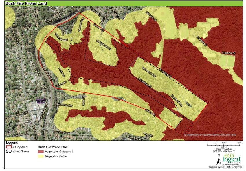
9.1.4        Floor Space Ratio                                                            48
             Preliminary options for consideration for the Hornsby DCP 2013               48
9.2.1        Biodiversity controls                                                        48
9.2.2        Tree preservation                                                            48
9.2.3        Buffer Zones                                                                 48
9.2.4        Site Coverage                                                                49
9.2.5        Other opportunities for change                                               49
             Economic considerations                                                      50

10           NEXT STEPS FOR THE BYLES CREEK PLANNING STUDY                                53

FIGURES
Figure 1     Map of the Byles Creek Study Area                                            10
Figure 2     Byles Creek Riparian Corridor                                                13
Figure 3     Dense vegetation within the Byles Creek Study Area                           14
Figure 4     Slope map                                                                    16
Figure 5     Strahler Stream Order map                                                    17
Figure 6     Watercourses Map                                                             18
Figure 7     Soil Landscape Map                                                           19
Figure 8     Vegetation communities map                                                   20
Figure 9     Ecological constraints within the Study Area                                 23
Figure 10    Bushfire prone land map                                                      24
Figure 11    Existing Bushfire Constraints mapping                                        25
Figure 12    Heritage Map, Hornsby LEP 2013                                               26
Figure 13    Infrastructure map                                                           27
Figure 14    Sydney Water and drainage infrastructure                                     28
Figure 15    Hornsby Shire Council’s relevant policy framework                            30
Figure 16    NSW Planning Framework                                                       32
Figure 17    Land use zoning map, Hornsby LEP 2013                                        34
Figure 18    Terrestrial Biodiversity mapping overlay                                     36
Figure 19    Vegetation Mapping Planning Proposal mapping overlay                         36
Figure 20    View of the Byles Creek corridor from Sutherland Road                        43

TABLES
Table 1      Habitat features and associated groups recorded in the Study Area            21
Table 2      Relevant LEP Clauses                                                         35
Table 3      Residential and environmental land use comparison summary                    45
Table 4      Current Buffer zones in the DCP                                              49
Table 5      Current Maximum Site Coverage controls in the DCP                            49
Table 6      Other opportunities for change                                               49
Table 7      High level analysis of economic considerations for the preliminary options   50

Discussion Paper                                                                               3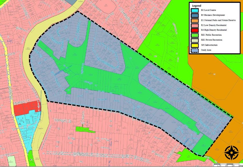
Glossary
 Term                    Definition

 Biodiversity            The variability among living organisms from all sources including terrestrial, marine and
                         other aquatic ecosystems, and the ecological complexes of which they are part; this
                         includes diversity within and between species and ecosystems.

 Corridor                A linear strip of vegetation that provides a continuous (or near continuous) pathway
                         between two habitats.

 Connectivity            The physical or functional capability of organisms to move between patches of habitat.
                         These connections are often fragmented in urban environments; however, provide
                         important ecological features and elements for species to migrate from one habitat to
                         another to find food and shelter.

 Ecological resilience   Ecological resilience is the capacity of an ecosystem to respond to a disturbance by
                         resisting damage and recovering quickly. Resilience is dependent on components
                         functioning.

 Ecology /               Ecology is the study of plants and animals, and their interaction with the environment.
 ecosystems              Urban ecology is the study of the relationship between living organisms and their
                         environment in an urbanised context. Living organisms and the ecosystems they form
                         are commonly termed ‘biodiversity’, a truncation of the words ‘biological’ and ‘diversity’.

                         Ecosystems comprise of natural components, such as plants, animals, water, soil, air
                         and their interactions. Cities are urban ecosystems which include both nature and
                         humans, in a predominately human-built environment. Functioning ecosystems are the
                         foundation of human wellbeing and most economic activity.

 Green Infrastructure    There are various descriptions for green infrastructure. The term is often used to
                         describe the layers and infrastructures in urban environments that directly provide
                         multiple ecosystem services or support the provision of those services. Examples of
                         green infrastructure in Hornsby Shire include; all vegetation, parks, street trees,
                         gardens, reserves, greenways, living green roofs and walls, stormwater and rainwater
                         harvesting, permeable surfaces, waterways and wetlands.

 Habitat                 The physical environment where an organism or population naturally occurs. It includes
                         all of the conditions an organism needs to survive; for example, for an animal, that
                         means everything it needs to find and gather food, select a mate, and successfully
                         reproduce.

                         Urban habitat can be highly modified and are extremely diverse. They can vary from
                         parks, to vacant lots, to degraded channels, to yards, golf courses, bridges, landfills.

 Hollow bearing tree     A hollow-bearing tree is a dominant or co-dominant living tree, where the trunk or limbs
                         contain hollows, holes or cavities. Such hollows may not always be visible from the
                         ground but may be apparent from the presence of deformities such as protuberances of
                         broken limbs, or where it is apparent the head of the tree has broken off.

                         Hollows provide habitat for a range of species and are usually found in mature trees.
                         The cavity opening size and depth varies, from small openings (2-6cm in diameter) to
                         large (18-30cm in diameter).

Discussion Paper                                                                                                       4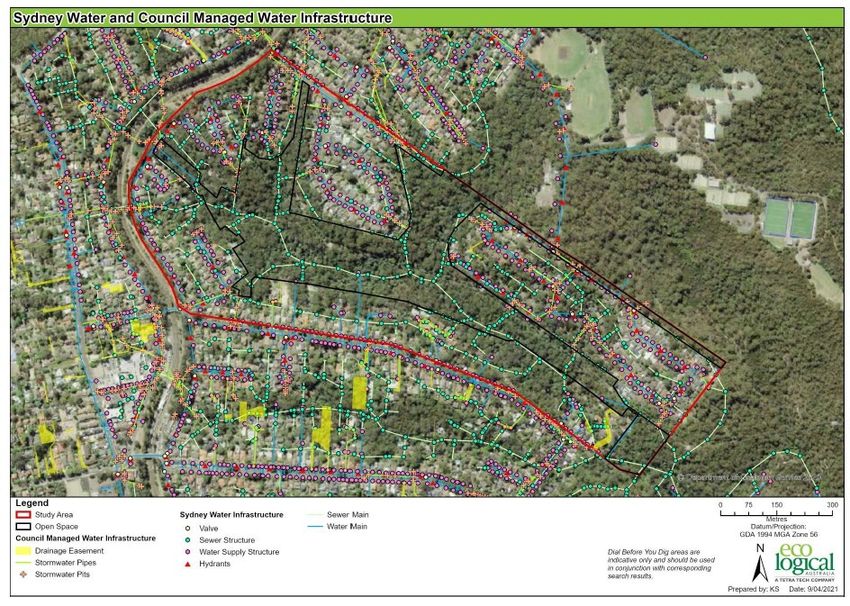
Term                 Definition

 Link or linkage      Refers to an arrangement of habitat (not necessarily linear or continuous) that
                      enhances the movement of animals or the continuity of ecological processes through
                      the landscape.

 Locally indigenous   Plants that occur naturally in the local area and are adapted to local rainfall and soil
                      conditions. These will cover a range of forms from substantial trees to shrubs,
                      groundcover and climbers. They provide an important habitat and food source for local
                      wildlife.

 Planning framework   Hornsby Shire Council’s key planning polices which manage land use and development,
                      including the Hornsby Local Environmental Plan 2013 and the Hornsby Development
                      Control Plan 2013.

 Stepping stone       One or more separate patches of habitat in the space between key habitat, that provide
 habitat              resources and refuge that assist animals to move through the landscape.

Discussion Paper                                                                                                 5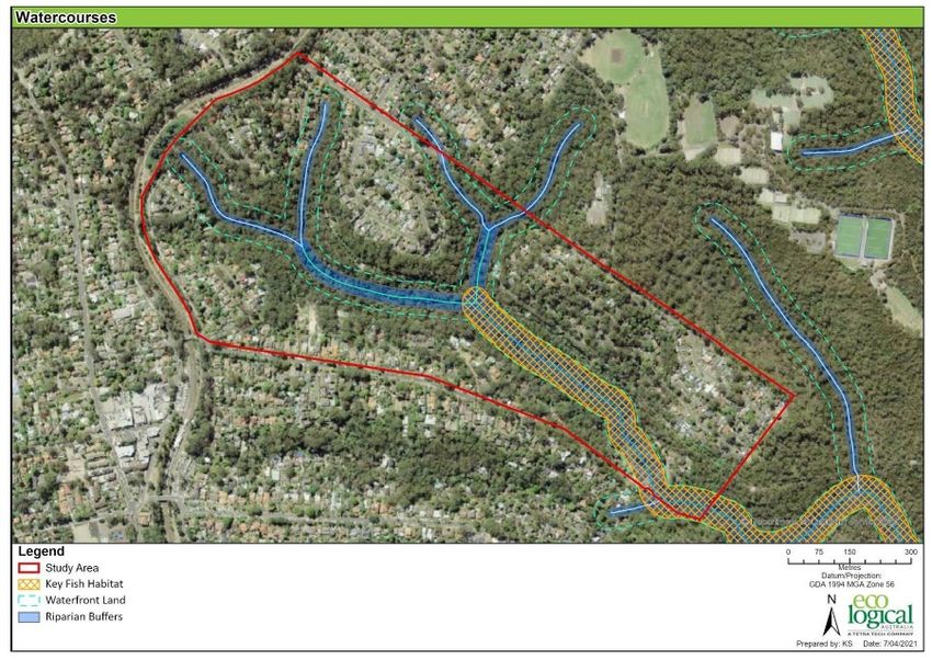
Common planning acronyms, terms
and definitions
 Term              Definition

 EP&A Act          Environmental Planning and Assessment Act 1979
                   Is the principal legislation in New South Wales (NSW) governing how the relevant
                   planning authority should take into consideration the impacts to the environment
                   (both natural and built) and the community of proposed development or land-use
                   change.
                   Where other statutes are referenced in this document, they are spelled out in full.

 DA                Development Assessment

 DCP               Development Control Plan
                   A Development Control Plan (DCP) provides detailed planning and design guidelines
                   to support the planning controls in the Local Environmental Plan (LEP). It identifies
                   additional controls and standards for addressing development issues at a local level.

 District Plan     North District Plan
                   The North District Plan is a 20-year plan to manage growth in the context of
                   economic, social and environmental matters to achieve the 40-year vision for
                   Greater Sydney.

 EEC               Endangered Ecological Communities
                   An ecological community listed as facing a very high risk of extinction and is
                   protected in NSW under the Biodiversity Conservation Act 2016.

 LEP               Local Environmental Plan
                   A statutory planning document that guides planning decisions for local government
                   areas. They do this through zoning and development controls, which provide a
                   framework for the way land can be used.

 LGA               Local Government Area

 LSPS              Local Strategic Planning Statement
                   The 20-year vision for land use in the local area, the special character and values
                   that are to be preserved and how change is managed in the future.

 Region Plan       A Metropolis of Three Cities – the Greater Sydney Region Plan
                   A metropolitan wide plan that sets a 40-year vision and establishes a 20-year plan to
                   manage growth and change for Greater Sydney in the context of social, economic
                   and environmental matters.

 SEPP              State Environmental Planning Policy
                   Planning instruments that deal with matters of State or Regional significance. The
                   effect of a SEPP is that it can override local statutory controls (LEP) and can prohibit
                   or allow certain types of development within a zone. It can also provide additional
                   provisions to an LEP.

Discussion Paper                                                                                              6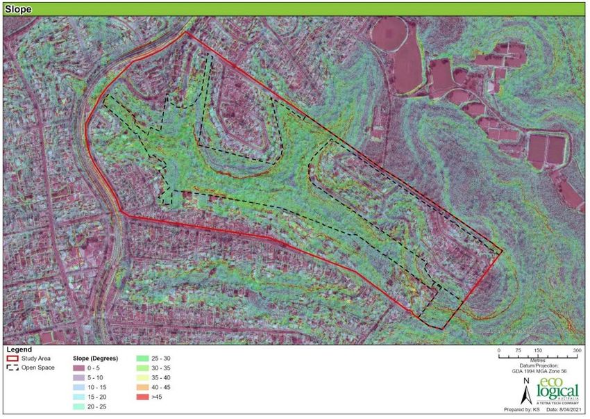
1            Purpose of this Discussion Paper
The Byles Creek Planning Study seeks to improve the Hornsby local planning framework to enhance and protect
ecology, biodiversity and ecosystems within Byles Creek corridor. The purpose of this Discussion Paper is to
encourage conversation and seek comment from the community and stakeholders about these opportunities.
Due to the high environmental quality, aesthetic and heritage value to the local community and the Shire in
general, Hornsby Shire has commissioned a number of studies and reviews for the Byles Creek Corridor (refer to
Section 2.4 of this Discussion Paper). These studies and reviews have focused on larger areas than the area of
which the current Planning Study relates.
To inform refined, considered and effective inputs into Council’s existing local planning framework, including the
Hornsby Local Environmental Plan 2013 and Hornsby Development Control Plan 2013, we must now focus on
private land which lies adjacent to the Byles Creek corridor where the impacts of future development would be
the most significant. We must also elevate our thinking and consider the biodiversity and ecological values of
Byles Creek in order to understand the interactions and dependencies within the ecosystem. Using a holistic
approach, we can better understand the impacts of planning decisions and the associated trade-offs.
Healthy ecosystems and biodiversity are vital for the liveability and amenity of Hornsby Shire. We are currently
contending with the most complex challenges in the history of the Shire’s development. The way in which we can
increase capacity to cope with a rapidly increasing population, increased development and plan for future climate
change through resilience will fundamentally affect the native flora and fauna that lives within the Byles Creek
ecosystem and the Hornsby Shire more broadly.

Providing your feedback
This Discussion Paper aims to highlight key issues and ideas that need deeper consideration and feedback from
the community and stakeholders. At the end of relevant chapters, you will find a series of questions, which we
hope will stimulate thought and discussion. We invite you to join the conversation and share your thoughts and
ideas online as part of the engagement.
Your input is critical to understanding why the Byles Creek area is such a significant and unique place and what
changes you may hope to see to effectively protect the unique environmental characteristics of the corridor.
This Discussion Paper has been prepared for community and stakeholder comment and input.
Council has not concluded any view on the opportunities for change identified in this document and
will resolve a final strategy when it has considered community feedback on both this Discussion
Paper and after exhibition of the final draft Byles Creek Planning Study.
Find out more and join the conversation at: https://www.hornsby.nsw.gov.au/council/noticeboard/your-
say/current-exhibitions/community-consultation-register-your-interest-byles-creek-planning-study

Discussion Paper                                                                                                     7
2            About the Byles Creek Planning
             Study
             Overview
Hornsby Shire Council’s (Hornsby Shire’s) natural environment is one of the hallmarks of the area. Hornsby Shire
is known as the “Bushland Shire”, not only for the Local Government Area’s abundant bushland but for the
biodiversity in flora and fauna, waterways and rural areas. Hornsby Shire’s natural environment plays a vital role,
not only for the Hornsby community but also for the region and Greater Sydney.
Extensive community engagement has been undertaken as part of the development of Community Strategic Plan
and Environmental Sustainability Strategy. Feedback shows the Hornsby Shire community wants to ensure that
local environments are protected and enhanced, and that Hornsby Shire is resilient and able to respond to climate
change events and stresses.
Hornsby Shire has committed to progress a review of the planning controls for residential properties adjoining
open space zoned land within the Byles Creek corridor. This review is the subject of the Byles Creek Planning
Study (the Planning Study). Council has engaged an experienced multidisciplinary team, led by Elton Consulting,
with input from Eco Logical Australia and AEC, to undertake the Planning Study.
The Planning Study will have regard to protection and maintenance of the environmental and social values of the
area. It will investigate implementation measures to protect the biodiversity values and ecosystem functionality of
the corridor.
Through the Planning Study, Council is seeking to understand how effective current planning controls are in
protecting the interface between the public open space zoned area and the residential zoned land surrounding it
from fragmentation, increased runoff and loss of habitat (such as trees and vegetation). The outcomes of the
Planning Study will be used to inform any recommendations for changes to planning controls, including the
Hornsby Local Environmental Plan 2013 (LEP) and the Hornsby Development Control Plan 2013 (DCP).
The Planning Study includes engagement with landowners, interest groups and the broader community to obtain
input on the key environmental, economic, social and aesthetic attributes of the Byles Creek corridor. The
engagement process also seeks to identify opportunities and constraints with existing and potential planning
controls as well as other mechanisms for enhanced protection and management of the corridor.
The Planning Study accounts for the significant landscape within the Byles Creek corridor, while at the same time,
reviewing how residential properties surrounding the area can minimise impacts on the natural environment.
The method that underpins the Planning Study is comprised of five interlinked parts, summarised as follows:
    1. Existing Situation – Background review of policies, studies and analysis of best practise case studies to
       develop an evidence base
    2. Land use survey – Environmental constraints and opportunities mapping and analysis of various
       attributes pertaining the site study area
    3. Community engagement – Engagement with landowners, community and interest groups, as well as
       the broader community
    4. Analysis of information – Analysis of planning controls from other comparable councils with respect to
       development on sites with an interface with environmentally sensitive / significant land
    5. Recommendations – Preparation of the Byles Creek Planning Study, which consolidates all project work
       undertaken and provides recommendations and priorities for Council’s planning framework and
       supporting building techniques/designs to minimise environmental impacts on private land and the
       adjoining corridor.

Discussion Paper                                                                                                  8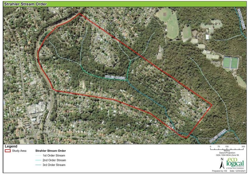
Some of the potential benefits that enhanced environmental outcomes can provide to the Byles Creek and the
broader Hornsby Shire community include:
»    Environmental benefits – Air pollution reduction, carbon storage, urban cooling, nutrient cycling, water
     filtration and moderation.
»    Human benefits – Improved health, wellbeing and mental state, cultural and spiritual value, relaxation,
     shade, comfort, play and learning.
»    Ecological benefits – Improved health of ecosystems, seed dispersal, pollination, insect control, improved
     species balance and diversity.
»    Economic benefits – Energy savings, increased land value, increased productivity and creativity, reduced
     financial burden on health and emergency services.

             Delivering on project objectives
There are a number of clear objectives for the Byles Creek Planning Study. These are to:
    a) Assess the suitability of the current planning controls in protecting the environmental qualities of the Byles
       Creek corridor area;
    b) Develop a strategy that will minimise the impact of residential development and reflect the environmental,
       social and aesthetic qualities of the adjoining the Byles Creek corridor; and
    c) Identify, through a comparison with development controls of other Council areas, recommendations for
       improvements to Hornsby’s planning controls to protect the environmental, social and aesthetic qualities.

             The Study Area
The Study Area comprises private properties zoned R2 Low Density Residential surrounding the Byles Creek
corridor public open space zoned land (Figure 1). Development generally comprises single or two storey
detached dwellings. The majority of land along the existing Byles Creek corridor is zoned RE1 Public Recreation
and comprises intact dense native vegetation.
Coastal Enriched Sandstone Moist Forest is the most represented vegetation community within the corridor. This
community is associated with Blackbutt Gully Forest and is a locally significant community within the Hornsby
Local Government Area.
The Byles Creek corridor has been identified as environmentally significant due to the unique environmental,
social and aesthetic values of the area. The corridor provides connectivity between the vegetation along Byles
Creek and Lane Cove National Park. The connectivity of this corridor ensures the ability for native fauna to
disperse between nearby reserves and the national park as well as providing habitat.
The corridor provides critical natural habitat to endangered and threatened local flora and fauna, such as the
Powerful Owl, Gang Gang Cockatoo and Deane's tea-tree (Leptospermum deanei) and Blackbutt Smooth-barked
Apple Tall Open Forest community. The corridor provides high biodiversity values as recognised by its inclusion
within Council’s Terrestrial Biodiversity Map (Hornsby Local Environmental Plan 2013).
The Study Area contains bushfire prone land and falls within the Beecroft-Cheltenham Heritage Conservation
Area, as well as containing heritage listed properties.
Potential impacts to the Byles Creek corridor within the Study Area include further loss of habitat (including trees,
understorey and ground cover vegetation), fragmentation and edge effects as result of development and clearing
for bushfire Asset Protection Zones (APZ), pollution into the catchment from increased runoff, weed and feral
animal invasion (such as foxes and feral cats).

Discussion Paper                                                                                                    9
Figure 1 Map of the Byles Creek Study Area
Source: Hornsby Shire Council
Discussion point:
Q: What are the most important characteristics of the public open space lands in Byles Creek
corridor to you?
Q: What are the most important characteristics of the residential lands in Byles Creek corridor to
you?
Background
The Byles Creek corridor provides high environmental, scenic, social and heritage value to the local community
and Hornsby Shire in general. Because of this value, the corridor has been subject to a number of studies and
reviews, including the Byles Creek corridor Environmental Study (and subsequent site specific DCP) and the Byles
Creek Land Acquisition Strategy Review (DFP, July 2020). This background is summarised in further detail below.
Byles Creek corridor Environmental Study, 1995
In October 1995, the Byles Creek corridor Environmental Study investigated approximately 350 hectares of
publicly and privately-owned land in Beecroft and identified that the Open Space zoning for the Byles Creek
corridor area should be retained due to the high environmental quality, aesthetic and heritage value to the local
community and Hornsby Shire.
Discussion Paper 10The Study recommended the following:
» All existing zones as (currently) contained in Hornsby Shire Local Environmental Plan (LEP) 1994 be retained,
i.e. land zoned Open Space A remain Open Space A and not be zoned Environmental Protection B.
» No additional land be rezoned to Open Space A.
» A draft LEP be prepared to amend Hornsby LEP 1994 to designate areas identified as having Vegetation
Conservation Significance as “Bushland Protection” (and therefore being subject to the provisions of clause
19 of Hornsby Shire LEP 1994).
» A Plan of Management be prepared in relation to all land zoned Open Space within the catchment.
» Establish a program for acquisition of privately-owned land which is zoned Open Space A.
» Prepare detailed development guidelines for the catchment. In this regard, the Study led to the preparation
of the Byles Creek Development Control Plan (DCP) which came into force in May 1998.
At its General Meeting on 1 November 1995, Council resolved to adopt the recommendations of the Byles Creek
Environmental Study. As such, for the purposes of this Planning Study, the findings of the Byles Creek
Environmental Study are noted while acknowledging there are some limitations in its application 25 years after
preparation and endorsement.
Byles Creek Development Control Plan, 1998
As a result of the Byles Creek corridor Environmental Study, the Byles Creek Development Control Plan (DCP) was
prepared in May 1998 with site specific development controls including:
» a minimum setback requirement of 10m from land zoned open space,
» drainage controls requiring on-site detention,
» soil management controls,
» environmental protection, including retention of natural features such as rocky outcrops and significant trees
» landscape plan requiring 100% locally indigenous species
» designing buildings to provide protection of any significant trees and minimising earthworks on steep slopes,
including pier foundations.
» requirement for Flora and Fauna assessment reports on land zoned, or adjoining land zoned, open space
» biodiversity friendly fencing along bushland Protection areas
» bushfire protection measures, including Asset Protection Zones
» retention of natural watercourses
» parameters for determining sensitive land.
The above provisions have generally been incorporated into the current Hornsby DCP 2013 and applied more
broadly across the LGA.
Open Space Review, 2006
In 2006, an Open Space Review evaluated all lands in Hornsby Shire in private ownership which were zoned Open
Space A (under the now repealed Hornsby Shire LEP 1994) to ensure that they met community needs, preserved
environmental qualities of the Shire and a financial strategy was in place for the acquisition of privately-owned
lands. With respect to land within Byles Creek corridor, the Review recommended the retention of the open space
zoning for Byles Creek due to the high environmental, social, aesthetic and heritage values expressed by the
community and acknowledged acquisition of privately-owned lots may be required.
Discussion Paper 11Hornsby Development Control Plan, 2013
In October 2013, the Hornsby Development Control Plan 2013 came into effect and applied to all land within the
Hornsby Local Government Area, including land to which the Byles Creek DCP previously applied. This resulted in
the removal of the site-specific provisions for Byles Creek, with natural environment controls applying more
generally across the LGA.
Byles Creek Land Acquisition Strategy Review, 2020
In August 2020, the Byles Creek Land Acquisition Strategy Review assessed the environmental and social values
of Byles Creek corridor in order to review the strategic approach towards land acquisition within the catchment of
Byles Creek. Based on the ecological values of the corridor, the Strategy Review concluded that the current extent
of the RE1 zoning was appropriate, and no additional land is required to be acquired by Council other than lots
already identified, to protect the biodiversity values and ecosystem functionality of the corridor. Further, the
current zoning is sufficient in terms of satisfying the objectives and terrestrial biodiversity provisions of the
Hornsby Local Environmental Plan 2013.
However, following Council’s considerations of the findings of the Strategy Review and significant community
comment, Council resolved to progress this review of the suitability of the planning controls for residential
properties adjoining open space zoned land within the Byles Creek corridor with regard to protection and
maintenance of the environmental values.
Vegetation Mapping Planning Proposal
Hornsby Shire is currently progressing a planning proposal that seeks to update and expand the Terrestrial
Biodiversity Map within the Hornsby Local Environmental Plan 2013 and replace the term “Terrestrial Biodiversity”
with “Environmentally Sensitive Land” in Clause 6.4. The objective of the Planning Proposal is to implement
Council’s policy intent to enhance the protection and management of vegetation by ensuring the appropriate level
of consideration and assessment is undertaken for development proposals.
The Planning Proposal is currently being assessed by the NSW Department of Planning, Industry and
Environment.
Discussion point:
Q: Are you aware of Council’s current planning controls and strategies to protect the Byles Creek
area?
If YES - Are these controls and strategies adequate?
If NO - Why?
Discussion Paper 123 Valuing the Byles Creek corridor
Corridors and connectivity
There is a growing body of research recognising the importance of connecting biodiversity in urban environments.
Connectivity has proven to enhance and protect biodiversity in increasingly fragmented and disturbed
environments, facilitating movement of native flora and fauna within the landscape.
Research shows connectivity enhances the protected areas
by maintaining and enriching species diversity. It also
Figure 2 Byles Creek Riparian Corridor
increases resilience to threatening processes such as
climate change by allowing movement to alternate areas as
climatic conditions impact traditional ranges. Despite the
level of habitat fragmentation and disturbance, connectivity
has also been seen to benefit biodiversity in urban
environments.
The International Union for Conservation of Nature (IUCN)
has recognised the value in supporting connectivity to small
protected reserves (i.e. those less than 10ha) within highly
urbanised environments. Connectivity allows native animals,
including birds and insects to travel safely between patches
of priority habitat as they forage for food, shelter and find
mates, connecting remnant vegetation that would
otherwise be entirely separated by human activities and
development such as roads, housing and industrial zones.
These connections are also important to native plants as
they allow for seeds and pollen to be dispersed.
Scattered trees, such as those found on residential land,
are also important in enabling movements of many arboreal
species between habitats as these species often will not
travel along the ground and therefore require suitably
spaced trees to enable their movements.
Source: Elton Consulting, 2021
Biodiversity values in Hornsby Shire
Hornsby Shire possesses significant biodiversity, particularly when compared to other Greater Sydney Metropolitan
Local Government Areas. This can be attributed to the diversity of habitats within the LGA, as well as the high
percentage of vegetation cover (bushland) within large and protected areas, reserves on lands managed by other
agencies (i.e. Transport for NSW) and private properties. This biodiversity is a significant and defining feature of
the ‘Bushland Shire’ and one that requires safeguarding for future generations
Diverse native fauna and flora live and move through urban environments, including endangered and threatened
species. Byles Creek is home to many native fauna species, including the Powerful Owl, Gang Gang Cockatoos and
the Little Bent-Winged Bat. The Byles Creek Corridor also accommodates the Critically Endangered Ecological
Community Blue Gum High Forest, regionally significant Coachwood Rainforest, locally significant Blackbutt Gully
Forest within the corridor.
Discussion Paper 13In addition to the requirements for species to
move safely and freely between their preferred Figure 3 Dense vegetation within the Byles Creek
habitats, many native (and threatened) species Study Area
require specific habitat resources for
sheltering, including nesting and roosting
habitats. Specifically, the Byles Creek corridor
supports numerous hollow-dependant fauna
such as Owls, Glossy Black Cockatoos,
Microbats, Possums, all of which utilise tree
hollows for shelter sites. As such, for large,
mature hollow-bearing trees within the
landscape of their home ranges is extremely
important and may not always be able to be
met by the availability of such resources
within public lands alone.
Reversing the trend of declining biodiversity
globally and locally, requires protecting and
enhancing biodiversity in urban areas. We
also recognise and value the benefits that
biodiversity brings to local environments and
communities, such as critical ecosystem
services and improving community health Source: Eco Logical Australia, 2021
and well-being. Some of the ecosystem
services provided by natural systems include carbon sequestration, air and water filtration, and urban cooling.
Wellbeing and community health benefits gained from biodiversity, include spiritual enrichment, cognitive
development, recreation and visual amenity.
As we begin to recover from the COVID-19 pandemic, there is a growing market and emerging price premium for
urban properties where environmental qualities and biodiversity is well conserved and the related landscape
values and amenity it can generate. This is particularly relevant as working from home is becoming the norm and
we are spending more time than ever at our place of residence.
Importance of biodiversity on private land
Private lands form an essential part of Hornsby Shire’s overall biodiversity values and there is a significant role of
public and private realms in the urban environment in maintaining biodiversity.
Council’s role in protecting and enhancing biodiversity on private land has limitations. Council is only involved if
development approval (DA) is required. As part of such DAs, Council has responsibilities to protect threatened
species and improve overall biodiversity. There are a range of tools to guide Council in DA assessments and
provide certainty for land owners and developers when preparing applications. These include zoning for
environmental protection and overlays depicting biodiversity or environmentally sensitive land in the local
environmental plan to planning controls (guidelines) in the DCP.
The improved effectiveness of ongoing biodiversity management and planning are necessary to ensure that
development can occur in a sustainable way. Effective management and planning can enable appropriate
development to proceed while preserving a finite and highly valuable environmental resource.
Discussion Paper 144 Existing Landscape
The following chapter describes land use and environmental constraints identified by Eco Logical Australia as part
of Part 2 – Land Use Surveys of the study.
Unique characteristics
The Byles Creek corridor provides substantial biodiversity values provided through areas of retained native
vegetation, including large areas in public reserve systems (i.e. Lane Cove National Park, Berowra Valley National
Park and land zoned RE1 – Public Recreation comprising the Byles Creek catchment and core corridor), as well as
substantial areas of native vegetation on private land.
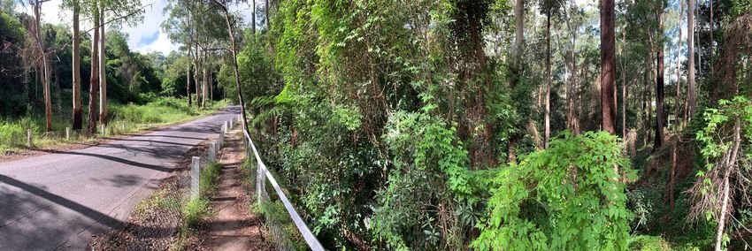
Residents and visitors to the area are able to see and hear rare and threatened native species (such as the Gang
Gang Cockatoo and Powerful Owl), as well as enjoy substantial amenity because of the unique area of
undeveloped or partially developed urban forest landscape.
The significant biodiversity values within the Byles Creek Study Area are:
» Critically Endangered Ecological Community Blue Gum High Forest
» Regionally significant Coachwood Rainforest
» Locally significant Blackbutt Gully Forest
» Connectivity to Lane Cove National Park (LCNP)
» Habitat for threatened fauna including Powerful Owl, Gang-Gang Cockatoo, Red-crowned Toadlet, Little
Bent-winged Bat and microbats
» Gang-gang Cockatoo endangered population
» Habitat for threatened flora including Brittle Midge Orchid (Genoplesium bauera), Deane's Tea-tree
(Leptospermum deanei), Tetratheca glandulosa and Darwinia biflora,
Topography
The topography of the Byles Creek Study Area ranges from flat in mainly residential areas to very steep along
ridge lines (Figure 4). The public open space zoned land is clearly defined by the topography. The slope
gradients in the public open space area are greater compared to residential properties. Steep slopes exceeding 45
degrees around the ridge lines are evident along contours of greatest elevation sloping down towards
streamlines. The topography of the Byles Creek Study open space zoned land is not suitable for urban
development due to steep slopes and associated risks.
Some increased risks associated with slope may also apply to residential zoned land surrounding the open space,
including greater bushfire, erosional, landslip and flood risk. Furthermore, the steepness of the catchment means
that any stormwater runoff from new properties could lead to additional erosion of the banks of the watercourse
or contribute additional sediment or pollutants to the catchment.
Discussion Paper 15Figure 4 Slope map
Source: Eco Logical Australia, 2021
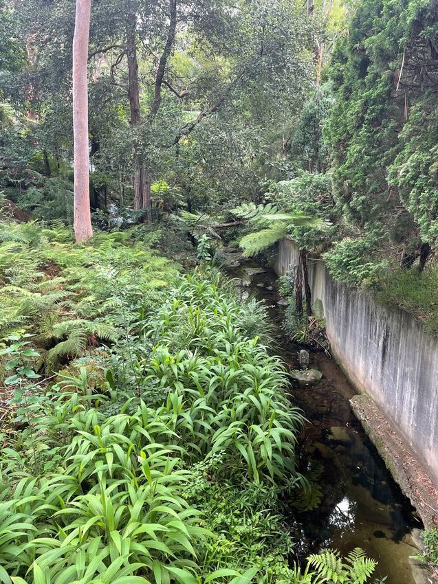
Watercourses and water quality
Within the Byles Creek Study Area there are seven watercourses that are all tributaries of Byles Creek. Four first
order, two second order and one third order creeks are accommodated within the study area boundary (Figure
5). These watercourses and their riparian zones vary in condition, likely as a result of their position in the
catchment.
Discussion Paper 16Figure 5 Strahler Stream Order map Source: Eco Logical Australia, 2021 Overall, Byles Creek and its tributaries are currently in good condition, however the edge effect of urban development alongside lower reaches of Byles Creek is evident. Where properties are in close proximity to the water, the creek is fringed by predominantly exotic species. The riparian vegetation adjacent to the Byles Creek tributary below the eastern end of Azalea Grove is in good condition, although the vegetation along the road edges and property boundaries is in poor condition and dominated by exotic shrubs and vines. These observations highlight the importance of maintaining a vegetated buffer between residential development and watercourses within Byles Creek catchment. Runoff from new properties could lead to additional erosion and consideration of the quality and quantity of stormwater runoff from new developments is important. Discussion Paper 17
Figure 6 Watercourses Map

Source: Eco Logical Australia, 2021

             Soil
Findings of the soil landscape analysis undertaken for the Byles Creek Study Area identify that the erosion
hazards for non-concentrated flows range from moderate to very high and for concentrated flows from high to
extreme. This has constraints on future development in regard to stormwater disposal off site, discharged
towards Byles Creek and its tributaries, which has the potential to easily erode the slopes leading down to the
watercourses at the bottom of the gullies. Erosion of the slopes above the watercourses can lead to
sedimentation and degradation of water quality within downstream environments including Lane Cove National
Park.
The four soil landscapes identified within in the study consist of distinct landscape, geological and soil
characteristics and include Hawkesbury (Colluvial), Lucas Heights (Residual), Glenorie (Erosional) and West
Pennant Hills (Colluvial) (Figure 7).

Discussion Paper                                                                                                  18
Figure 7 Soil Landscape Map
Source: Eco Logical Australia, 2021
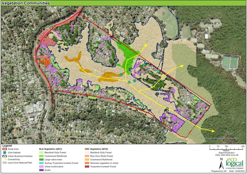
Ecology - Flora and fauna
Flora
A survey of flora and vegetation communities found three vegetation communities are present within the Byles
Creek Study Area. These include:
» Blue Gum Shale Forest:
At the north western end of the study area small areas of Blue Gum Shale Forest were present. The
dominant canopy was Eucalyptus saligna (Blue Gum), with occasional Angophora costata (Sydney Red
Gum) and Eucalyptus paniculata (Grey Ironbark). Understorey included small trees Allocasuarina torulosa
(Forest Oak), with ground layer of Adiantum aethiopicum, Lomandra longifolia and Plectranthus
parviflorus. Some examples of this community were present as remnant trees with little native
understorey.
» Blackbutt Gully Forest:
The majority of the study area was vegetated by Blackbutt Gully Forest with the dominant canopy species
included Eucalyptus pilularis (Blackbutt), Angophora costata (Smooth-barked Apple), Syncarpia
glomulifera (Turpentine) and Corymbia gummifera (Red Bloodwood). Understorey included shrubs of
Banksia spinulosa, Xanthorrhoea arborea, and Persoonia linearis.
» Coachwood Rainforest:
Two areas within the creek line were vegetated by Coachwood Rainforest with dominant canopy of
Ceratopetalum apetalum. Understorey included small trees of Tristaniopsis laurina, Callicoma serratifolia,
Discussion Paper 19sedges including Gahnia clarkei, ferns such as Blechnum ambiguum, Sticherus flabellatus, and vines
including Cissus hypoglauca. Morinda jasminoides and Smilax glyciphylla. Weeds included Ligustrum
sinense and Ageratina riparia.
Remnant tree canopy species were found to be present within front and back yards of private properties and
contain both remnant urban trees and plantings.
The interface between the urban and bushland areas and vegetation communities has been mapped as shown in
Figure 8. The interface is defined by mapping vegetation communities within the bushland area, and mapping
remnant trees within the urban area. Whilst most of the bushland is within the public open space, some bushland
occurs within privately owned land.
Figure 8 Vegetation communities map
Source: Eco Logical Australia, 2021
The vegetation within the Byles Creek corridor also contains suitable habitat for 30 threatened flora species
(identified by BioNet Wildlife Atlas records) within a 5 km radius of the study area. There are several records of
threatened flora species within or in close proximity to the study area including:
» Darwinia biflora;
» Genoplesium bauera (Brittle midge orchid);
» Leptospermum deanei (Deane's tea-tree); and
» Tetratheca glandulosa.
Discussion Paper 20Fauna
There are several rare or threatened bird species including the Glossy Black and the Gang Gang Cockatoos that
utilise habitat and feed on trees which occur across the private and public lands within the Byles Creek Study
Area. Other rare or endangered birds that occur in the area are Powerful Owls which need wide habitats and tall,
hollow trees.
The following fauna species and habitats assessment undertaken by Eco Logical Australia summarises vegetation
types found within the study area which provides suitable habitat for a number of common peri-urban species
and threatened fauna species.
Table 1 Habitat features and associated groups recorded in the Study Area
Habitat Features Guild Presence in the Study Area
Remnant vegetation Birds, microchiropteran bats (microbats), Present and extensive within Byles
megachiropteran bats (fruit bats), Creek corridor. Remnant canopy also
arboreal mammals, reptiles present within private properties.
Winter flowering species Winter migratory birds, arboreal Limited.
mammals and megachiropteran bats (fruit
bats)
Hollow-bearing trees Birds and arboreal mammals (gliders and Present, and ranging in size from small
(HBT) microbats) hollows able to support smaller species
such as microbats to larger hollow
dependant species such as owls.
Stags Birds, particularly birds of prey, reptiles, Present and likely to provide habitat
amphibians, micro bats for larger hollow dependant species
such as owls.
Leaf litter Reptiles, amphibians, invertebrates Abundant. Deep leaf litter is present
across a large portion of the study
area within Byles Creek corridor.
Limited leaf litter within urban areas.
Coarse woody debris Terrestrial mammals, reptiles, Present, logs present within Byles
invertebrates Creek corridor.
Watercourses Amphibians, reptiles, water birds and Present – ephemeral streams, 1st 2nd
microbats and 3rd order Strahler streams present
within study area and is suitable
habitat for threatened amphibian
species.
Rocks/ rocky outcrops Reptiles, invertebrates, terrestrial Abundant – rocky sandstone
mammals outcropping and large rocks abundant
within Byles Creek corridor.
Vegetative corridor Birds, reptiles, arboreal and small Present and extensive within Byles
mammals Creek corridor. Remnant canopy also
present in front and back of private
property. Canopy vegetation contains
good connectivity through planted
native and exotic canopy species
within private property.
Mistletoe Birds and arboreal mammals Absent
Discussion Paper 21Habitat Features Guild Presence in the Study Area
Native/ Exotic grassland Migratory wetland birds (Egrets), predator Limited
bird species (Little Eagle) and microbats
Source: Eco Logical Australia, 2021
The Byles Creek corridor contains suitable habitat for 30 threatened flora species within a 5 km radius of the
study area. There are several records of threatened fauna species within or near the study area including:
» Gang-gang Cockatoo (Callocephalon fimbriatum):
In 2001 the population was listed as endangered by the NSW Scientific Committee which found that the
numbers of the Gang-gang Cockatoo population in the Hornsby and Ku-ring-gai Local Government Areas
have been reduced to such a critical level, and its habitat has been so drastically reduced, that it is in
immediate danger of extinction. The small population was the last known breeding population in the
Sydney Metropolitan area, estimated at that time to be between 18 - 40 pairs. The species and
population is dependent on the retention of potential nest trees which are forest and woodland eucalypts
containing hollows.
» Micro bats:
The vegetation within the study area is likely to be used as foraging habitat for threatened for microbat
species; threatened microbat species may also forage along the streams identified within the study area.
Threatened microbat species listed under the BC Act and/or EPBC Act which are likely to forage within he
study area and have been recorded from the BioNet Wildlife Atlas search include; Falsistrellus
tasmaniensis (Eastern False Pipistrelle), Micronomus norfolkensis (Eastern Coastal Free-tailed Bat),
Miniopterus australis (Little Bent-winged Bat), Myotis macropus (Southern Myotis), Scoteanax rueppellii
(Greater Broad-nosed Bat), Miniopterus orianae oceanensis (Large Bent-winged Bat), Chalinolobus dwyeri
(Large-eared Pied Bat) and Saccolaimus flaviventris (Yellow-bellied Sheathtail-bat).
» Powerful Owl (Ninox strenua):
BioNet Wildlife Atlas records over 1000 sightings of Ninox strenua within a 5 km radius of Byles Creek
since the 1980s. The species can breed and forage in very small patches of vegetation but require nest
trees in living or dead trees with hollows greater than 20 cm diameter. The Sydney Powerful Owl Project
(POP) have noted that due to the scarcity of urban tree hollows from development, competition with
other nesting hollow bird species and high mortality rates of young fledglings, Powerful Owl populations
will continue to reduce without appropriate management.
» Koala (Phascolarctos cinereus):
There are 6 BioNet Wildlife Atlas records for Koala recorded within a 5 km radius of the study area.
Further, there is foraging habitat (including feed tree species) for Koala within the study area, both in the
vegetated corridor and on private properties. Koala is listed as a Vulnerable species under the BC Act and
EPBC Act. Hornsby local government area is included within the State Environmental Planning Policy
(Koala Habitat Protection) 2021.
» Amphibians
The study area contains ephemeral streams (1st 2nd and 3rd order Strahler streams), with deep leaf litter
and rocks present along the banks of the streams within the study area. And The streams are suitable
habitat for amphibians; including threatened amphibian species listed under the BC Act and/or EPBC Act;
Pseudophryne australis (Red-crowned Toadlet) and Heleioporus australiacus (Giant Burrowing Frog).
There are 22 and 2 BioNet Wildlife Atlas records within a 5km radius of the study area for the Red-
crowned Toadlet and Giant Burrowing Frog, respectively.
» Dural Land Snail (Pommerhelix duralensis):
Discussion Paper 22The Dural Land Snail has been recorded within a 5 km radius of the study area. Dural Land Snail favours
sheltering under rocks or inside curled-up bark. It does not burrow nor climb. The species has also been
observed resting in exposed areas, such as on exposed rock or leaf litter, however it will also shelter
beneath leaves, rocks and light woody debris (Ridgeway et al., 2014). Dural Land Snail is listed as
Endangered under the BC Act and EPBC Act. However, habitat on private lands for this species is less
likely to be utilised in comparison to the better-quality habitat within the intact vegetation on public open
space lands.
Ecological constraints
The above findings on significant biodiversity values (flora and fauna) in the study area, or within close vicinity to
the study area, are mapped as ecological constraints on the following map (Figure 9). Areas mapped as high
ecological value include all the identified significant biodiversity values. Areas mapped medium include remnant
urban trees and low includes urban developed land and exotic gardens as well as weedy vegetation.
Figure 9 Ecological constraints within the Study Area
Source: Eco Logical Australia, 2021
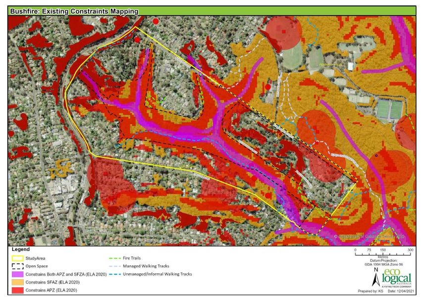
Bushfire
The Byles Creek Study Area is constrained by the presence of bush fire prone vegetation and the resulting
requirements of Planning for Bushfire Protection (RFS, 2019), as triggered by the Environmental Planning and
Assessment Act 1979 for development on bushfire prone land.
Discussion Paper 23The core Byles Creek corridor area (RE1 zone) is predominantly mapped as Vegetation Category 1, as shown in
Figure 10. This is the highest bushfire prone land category and corresponds to the highest bushfire risk, with
Category 1 bushfire prone land considered to have the highest likelihood of fully developed fires forming and is
subject to a 100m buffer. Much of the residential area surrounding the RE1 zones falls within the bushfire prone
vegetation buffer.
Figure 10 Bushfire prone land map
Source: Eco Logical Australia, 2021
The capacity of private land to meet bushfire protection measures is influenced by various constraints including:
» Provision of APZs and the ability of future development to meet setback requirements due to slope and
vegetation constraints.
» Access and the ability of future development meeting the requirements of Planning for Bushfire Protection,
particularly the provision of perimeter roads.
» Water supply and the ability of future development to meet the requirement of Planning for Bushfire
Protection.
To provide context to bushfire protection measures, some examples of different development types and their
ability to conform with bushfire protection requirements (within the Study Area) has been undertaken and is
summarised as follows:
» in fill development: capacity to meet PBP requirements.
» dual occupancy*: capacity to meet PBP requirements are limited due to access and APZ constraints.
» subdivision: capacity to meet PBP requirements are limited due to access and APZ constraints.
Discussion Paper 24» childcare/schools/nursing homes and other SFPP development: capacity to meet PBP requirements unlikely
due to SFPP APZ and access requirements.
*Please note that ‘dual occupancy’ is not a permitted use on land zoned R2 – Low Density Residential or RE1
– Public Recreation
Figure 11 Existing Bushfire Constraints mapping
Source: Eco Logical Australia, 2021
Heritage
The Study Area falls within the Beecroft-Cheltenham Heritage Conservation Area, as well as supporting heritage
listed properties under Schedule 5 of the Hornsby LEP (Figure 12).
Several items are listed as Environmental Heritage within the study area and shown on the Heritage Map (Figure
12) and include Street trees and bushland along Malton Road (I114) and Bushland Reserve adjacent to
Sutherland Road and Park Avenue – Byles Creek Valley (I140).
Discussion Paper 25Figure 12 Heritage Map, Hornsby LEP 2013
Source: Hornsby LEP 2013
Infrastructure
An analysis of infrastructure in the Byles Creek study area was undertaken using a compilation of sources
including Dial before you Dig, cadastre data, and shapefiles of Council and Government data (Figure 13 and
14).
The NBN telecommunications and gas (Jemena) networks are confined to the residential areas within the study
area extending mostly along the southern and western edges. The Optus search results showed one point within
residential property located in the north west. The telecommunications and gas infrastructure are wholly outside
the designated open space area.
TPG infrastructure, the electricity transmission line and easement extend through the study area from the north
west residential, transecting bushland along and within the northern Open Space boundary in the central region
of the study area until reaching the study area boundary in the south west. TPG infrastructure follows the
electricity transmission thus limiting impacts within the Open Space area.
The Sydney Water and council managed water infrastructure is an extensive network throughout the entire study
area, however, is less concentrated in the Open Space area. Sewer infrastructure is the predominate water
infrastructure type in the Open Space area with some water mains extending from the southern Open Space
boundary. Contamination from sewer overflow and leakages is associated risk, overflows can occur from
stormwater inflows and during dry periods from chokes, leaks from damaged pipes and damage from tree roots.
Discussion Paper 26Access to TPG, electricity transmission lines/easement and water infrastructure within the Open Space area is required for maintenance and repair and will need to be maintained. Figure 13 Infrastructure map Source: Eco Logical Australia, 2021 Discussion Paper 27
Figure 14          Sydney Water and drainage infrastructure

Source: Eco Logical Australia

          Discussion points:

          Q: Is reducing development opportunities on residential lands an appropriate way to protect and
          enhance the environmental for the Byles Creek area? Why?

Discussion Paper                                                                                            28
5 Strategic Policy Framework
State and local policies and strategies provide strong and clear support for protection of environmental values in
Hornsby Shire. These include the following documents and their key strategic statements:
» The Greater Sydney Region Plan – biodiversity is protected, urban bushland and remnant vegetation is
enhanced.
» North District Plan – Protect and enhance an interlinked network of open spaces to keep Hornsby Shire
cool, encourage healthy living, enhance biodiversity and ecological resilience.
» Community Strategic Plan – collaboratively implementing infrastructure, sustainability, liveability,
productivity and affordability initiatives to ensure our Bushland Shire thrives now and into the future.
» Local Strategic Planning Statement – improve the Shire’s waterways, biodiversity corridors, green
spaces and tree canopy to support the environment and a healthy community
» Sustainable Hornsby 2040 – ensure biodiversity is well-managed, resilient and adaptable to land use
changes and that we will have a healthy, thriving, diverse and valued urban forest
» Biodiversity Conservation Strategy – Protect and conserve ecological values, connect urban habitat and
restore disturbed ecosystems to enhance ecological value and function
Regional policy context
A Metropolis of Three Cities – The Greater Sydney Region Plan & North District Plan
A Metropolis of Three Cities – the Greater Sydney Region Plan (Region Plan) sets a 40-year vision for Greater
Sydney. The Region Plan presents a strong case for biodiversity connectivity – incorporating a key direction of ‘a
city in its landscape’. It identifies a vision for Greater Sydney that protects and manages natural systems,
incorporates natural landscape features into the urban environment and cools the urban environment. The Plan
informs District and local plans as well as the assessment of planning proposals.
Building on the Region Plan, the North District Plan (District Plan), sets out priorities and actions for the District,
which includes the Hornsby Shire LGA. The District Plan builds on ‘a city in its landscape’ theme, refining it for the
local context, identifying key initiatives to deliver the objective: Biodiversity is protected, urban bushland and
remnant vegetation is enhanced.
Incorporated within both the Region and District Plan, the Greater Sydney Green Grid is a mapped network of
high-quality green space that connects town centres, public transport hubs, and major residential areas. The
objectives of the green grid are to protect and enhance an interlinked network of open spaces to keep Hornsby
Shire cool, encourage healthy living, enhance biodiversity and ecological resilience.
Strategically, the Region and District Plans have informed the Hornsby Shire’s Local Strategic Planning Statement,
local environmental plan, local strategies (below), and the assessment of planning proposals (rezoning
applications).
Local Policy Context
Hornsby Shire has pledged to protect and enhance the LGA’s bushland environment through its Community
Strategic Plan and a raft of supporting documents (Figure 15). This includes Council’s commitment to protecting
and enhancing the Hornsby Shire’s natural environment.
Discussion Paper 29Figure 15 Hornsby Shire Council’s relevant policy framework
Community Strategic Plan
The Hornsby Shire Community Strategic Plan (CSP) identifies the main priorities and aspirations for the future of
Hornsby Shire, acting as Council's long-term plan to deliver the best possible services. It also sets the strategic
direction for where the people of Hornsby Shire want to be in 2028.
Through the CSP vision, Council is committed to
collaboratively implementing infrastructure, sustainability, liveability, productivity and affordability initiatives to
ensure our Bushland Shire thrives now and into the future.”
As part of the significant consultation program undertaken to develop the CSP, the community indicated that
they:
» Love living in the Hornsby Shire because of the natural environment particularly the bushland, national
parks, trees and green spaces. However, there are concerns amongst the community regarding
infrastructure, roads and development and particularly the changes to the landscape brought about by new
developments.
» Would like less development in general and a balance of better planning for developments with protection of
the environment, bush and green spaces.
The CSP includes sustainability outcomes which will help protect and enhance local natural surroundings.
Indicators of success include:
» Number of threatened plan and animal species;
» The natural environment is well catered for and protected; and,
» Waterways are protected.
Local Strategic Planning Statement
Council has developed the Local Strategic Planning Statement (LSPS) which identifies the long-term vision for the
Shire through reviewing and developing local strategies and plans that shape the way Hornsby Shire will change
over time. It identifies Hornsby Shire’s special characteristics and the values that are to be preserved and how
change will be managed into the future.
The LSPS addresses the themes of liveability, sustainability, productivity and collaboration and reflect the key
priorities identified by the community.
LSPS has planning priorities for sustainability that reiterate the need to improve the Shire’s waterways,
biodiversity corridors, green spaces and tree canopy to support the environment and a healthy community.
Discussion Paper 30You can also read