DRAFT 2040 WALTON COUNTY MOBILITY PLAN & MOBILITY FEE - March 2021 Prepared for: Prepared by
←
→
Page content transcription
If your browser does not render page correctly, please read the page content below

DRAFT 2040 WALTON COUNTY
MOBILITY PLAN & MOBILITY FEE
         March 2021

          Prepared for:

          Prepared by:
DRAFT 2021 Mobility Plan & Mobility Fee

                                                       TABLE OF CONTENTS
         Overview                                                                                            3
         Introduction                                                                                        4
         Legislative Background                                                                              3
         Legal                                                                                               9
         Comprehensive Plan                                                                                 14
         Mobility Plan                                                                                      17
         Mobility Fee                                                                                       27
         Vehicle Miles of Travel (VMT)                                                                      28
         Person Miles of Travel (PMT)                                                                       29
         Daily Road Capacity                                                                                30
         Multimodal Capacity                                                                                31
         Multimodal Projects                                                                                34
         New Growth Evaluation                                                                              35
         Funding                                                                                            36
         Person Miles of Capacity (PMC) Rate                                                                37
         Mobility Fee Assessment Areas                                                                      38
         Person Miles of Travel (PMT) per Land Use                                                          39
         Mobility Fee Schedule                                                                              40
         Mobility Fee Benefit District                                                                      41
         Definitions                                                                                        41
         Conclusion                                                                                         41

         Tables
         Table 1.                    Growth in Vehicle Miles of Travel (VMT)                                28
         Table 2.                    Increase in Person Miles of Travel (PMT)                               29
         Table 3.                    Daily Road Capacities                                                  30
         Table 4.                    Bicycling and Walking Person Capacity                                  32
         Table 5.                    Multimodal Daily Person Capacities                                     33
         Table 6.                    Summary of Multimodal Projects                                         34
         Table 7.                    New Growth Evaluation                                                  35
         Table 8.                    New Growth Adjustment                                                  37
         Table 9.                    Person Miles of Capacity (PMC) Rate                                    37

© 2021 NUE Urban Concepts, LLC. All rights reserved.                                                       Page 1
DRAFT 2021 Mobility Plan & Mobility Fee

         Figures
         Figure 1.                   Moving People Providing Choices                                       17
         Figure 2.                   Types of Projects in the Mobility Plan                                17
         Figure 3.                   Multimodal Elements                                                   19
         Figure 4.                   Speed of Travel                                                       20
         Figure 5.                   Street Quality of Service (QOS) Standards                             21
         Figure 6.                   Scenic 98 Multimodal Cross-Section                                    23
         Figure 7.                   30A Multimodal Cross-Section                                          25
         Figure 8.                   Mobility Plan and Mobility Fee                                        27

         Maps
         Map A.                      Miramar Beach Sandestin Walking & Bicycling Plan
         Map B.                      Miramar Beach Sandestin Transit Circulator Plan
         Map C.                      Miramar Beach Sandestin Multimodal Lanes Plan
         Map D.                      Miramar Beach Sandestin Roads Plan
         Map E.                      South Walton Walking & Bicycling Plan
         Map F.                      South Walton Transit Circulator Plan
         Map G.                      South Walton Micromobility & Microtransit Plan
         Map H.                      South Walton Roads Plan
         Map I.                      Central & North Walton Mobility Plan
         Map J.                      Central & North Walton Needs Plan
         Map K.                      Mobility Fee Assessment Areas
         Map L.                      Mobility Fee Benefit Districts

         Appendices
         Appendix A.                 Miramar Beach Sandestin Walking & Bicycling Plan
         Appendix B.                 Miramar Beach Sandestin Transit Circulator Plan
         Appendix C.                 Miramar Beach Sandestin Multimodal Lanes Plan
         Appendix D.                 Miramar Beach Sandestin Roads Plan
         Appendix E.                 South Walton Walking & Bicycling Plan
         Appendix F.                 South Walton Transit Circulator Plan
         Appendix G.                 South Walton Micromobility & Microtransit Plan
         Appendix H.                 South Walton Roads Plan
         Appendix I.                 Central & North Walton Mobility Plan
         Appendix J.                 Central & North Walton Needs Plan - Reserved
         Appendix K.                 2017 National Household Travel Survey Data
         Appendix L.                 FDOT Generalized Daily Service Volumes
         Appendix M.                 Mobility Fee Schedule

© 2021 NUE Urban Concepts, LLC. All rights reserved.                                                       Page 2
DRAFT 2021 Mobility Plan & Mobility Fee

                                                       OVERVIEW
In 1985, the Florida Legislature passed the Growth Management Act that required all local
governments in Florida adopt Comprehensive Plans to guide future development and mandated
that adequate public facilities be provided “concurrent” with the impacts of new development.
Transportation concurrency became the measure used by local governments to ensure that
adequate public facilities, in the form of road capacity, was available to meet the transportation
demands from new development. By 1993, the Florida Legislature recognized an unintended
consequence of transportation concurrency is that it essentially stopped development in urban
areas where road capacity was constrained pushed development to suburban and rural areas
where road capacity was either available or was cheaper to construct.

In 2007, the Legislature introduced the concept of mobility plans and mobility fees as a
replacement of transportation concurrency, proportionate share and road impact fees. In 2009,
the Legislature created Dense Urban Land Areas (DULAs) that allowed local governments to
adopt Transportation Concurrency Exception Areas (TCEAs). In 2011, the Legislature eliminated
state mandated transportation concurrency and made it optional for any local government. In
2013, the Legislature encouraged local governments to adopt mobility plans and fees as an
alternative to transportation concurrency, proportionate share and road impact fees. In 2019,
the Legislature required that mobility fees, based on an adopted plan of mobility improvements,
explicitly follow the requirements for impact fees per Florida Statute 163.31801.

The Walton County 2040 Mobility Plan is a vision, over the next 20 years, for how the County’s
transportation system will transition from one focused primarily on moving cars, towards a
multimodal system focused on safely providing mobility and accessibility for people of all ages
and abilities consistent with Florida Statute 163.3180 (5)(f). Achieving that vision will not happen
overnight; it will be an iterative process that involves coordinating land use, transportation,
parking, and funding. The Mobility Plan will serve as a guide to proactively plan for and prioritize
multimodal projects to meet the growth, travel, and mobility needs of the community. The
Mobility Plan also seeks to facilitate development of park-once environments along 30A and
Scenic 98 to encourage visitors to the County’s beach communities to park their car when they
arrive and use other forms of transportation to explore their destinations. The Mobility Fee is a
one-time fee paid by new development and redevelopment to mitigate the impact to the
County’s transportation system and fund the multimodal projects adopted as part of the Mobility
Plan. Mobility Fees were enacted by the Florida Legislature to provide developers an alternative
to transportation concurrency, proportionate share, and road impact fees.

© 2021 NUE Urban Concepts, LLC. All rights reserved.                                           Page 3
DRAFT 2021 Mobility Plan & Mobility Fee

                                                       INTRODUCTION
The Florida Constitution grants local governments broad home rule authority to establish
assessments and fees. Special assessments, impact fees, mobility fees, franchise fees, and user fees
or service charges are examples of these home rule revenue sources. Payment of mobility fees are
one of the primary means through which local governments can require new development, along
with redevelopment or expansion of existing land uses which generates additional transportation
demand, to mitigate its impact to a local governments transportation system. While road impact
fees and mobility fees are both intended to be means in which a development can mitigate its
transportation impact, the following are major differences between the two:

Road Impact Fees

•     Principally pay for the cost associated with adding new road capacity to move people driving
      vehicles (i.e., cars, trucks, SUVs, motorcycles).

•     Partially or fully fund road capacity improvements, including new roads, the widening of existing
      roads, and the addition or extension of turn lanes at intersections.

•     Are based on increases in vehicle miles of capacity from road improvements and the projected
      vehicle miles of travel from development.

•     Maybe based on either an adopted LOS standard (aka standards or consumption-based fee) or
      on future road improvements (aka plan or improvements-based fee).

Mobility Fees

•     Pay for the cost associated with adding new multimodal capacity to move people walking,
      bicycling, scooting, riding transit, driving vehicles or using shared mobility technology.

•     Partially or fully fund multimodal projects, including sidewalks, paths, trails, bike lanes,
      streetscape and landscape, complete and low speed streets, microtransit circulators,
      micromobility (i.e., electric bikes, electric scooters) devices, programs and services, microtransit
      (i.e., golf carts, neighborhood electric vehicles, autonomous transit shuttles, trolleys) services
      and vehicles, new roads, the widening of existing roads, and the addition or extension of turn
      lanes at intersections.

•     Are based on increases in person miles of capacity from multimodal projects and the projected
      person miles of travel from development.

•     Must be based on future multimodal projects adopted as part of a mobility plan and
      incorporated or referenced in the local governments Comprehensive Plan.

© 2021 NUE Urban Concepts, LLC. All rights reserved.                                                Page 4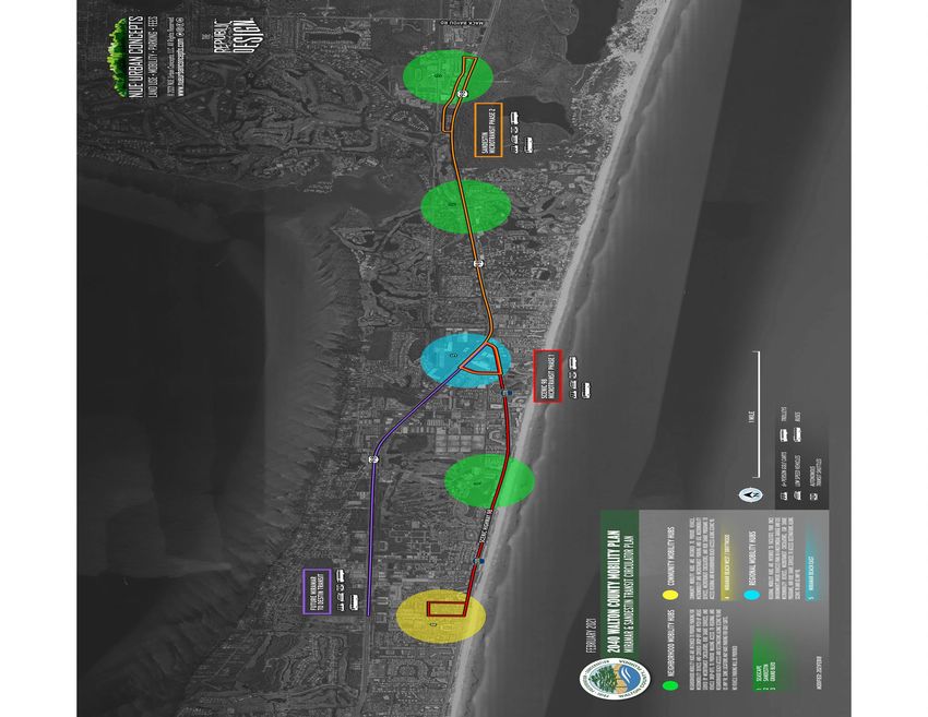
DRAFT 2021 Mobility Plan & Mobility Fee

                                             LEGISLATIVE BACKGROUND
The State of Florida passed the Growth Management Act of 1985 that required all local governments
in Florida to adopt Comprehensive Plans to guide future development. The Act mandated that
adequate public facilities must be provided “concurrent” with the impacts of new development.
State mandated “concurrency” was adopted to ensure the health, safety and general welfare of the
public by ensuring that adequate public facilities would be in place to accommodate the demand
for public facilities created by new development.

Transportation concurrency became the measure used by the Florida Department of Community
Affairs (DCA), Florida Department of Transportation (FDOT), Regional Planning Councils (RPCs),
and local governments to ensure that adequate public facilities, in the form of road capacity, was
available to meet the transportation demands from new development. To meet the travel
demand impacts of new development and be deemed “concurrent”, transportation concurrency
was primarily addressed by constructing new roads and widening existing roads.

Traditional transportation concurrency allowed governmental entities to deny development where
road capacity was not available to meet the travel demands from new development. Transportation
concurrency also allowed governmental entities to require that developments be timed or phased
concurrent with the addition of new road capacity. In addition, transportation concurrency also
allowed governmental entities to require new development to improve (widen) roads that were
already overcapacity (aka “deficient” or “backlogged’).

In urban areas throughout Florida, traditional transportation concurrency had the unintended
consequence of limiting and stopping growth in urban areas. This occurred because roads were
often over capacity based on traffic already on the roads or the combination of that traffic and trips
from approved developments. Further, the ability to add road capacity in urban areas was more
limited as right-of-way was often constrained by existing development and utilities, physical
barriers, and environmental protections. Stopping development in urban areas encouraged
suburban sprawl by forcing new development to suburban and rural areas where road capacity was
either readily available or cheaper to construct. In the late 90’s, as the unintended impact of
transportation concurrency became more apparent, the Legislature adopted Statutes to provide
urban areas with alternatives to address the impact of new development through Transportation
Concurrency Exception Areas (TCEA) and Transportation Concurrency Management Areas (TCMA).

© 2021 NUE Urban Concepts, LLC. All rights reserved.                                            Page 5
DRAFT 2021 Mobility Plan & Mobility Fee

The intent of TCEAs and TCMAs was to allow local governments alternative solutions to provide
mobility within urban areas by means other than providing road capacity and to allow infill and
redevelopment in urban areas. In the mid 2000’s, Florida experienced phenomenal growth that
strained the ability of local governments to provide the necessary infrastructure to accommodate
that growth. Many communities across the State started to deny new developments, substantially
raise impact fees and require significant transportation capacity improvements. In 2005, the
Legislature enacted several laws that weakened the ability of local governments to implement
transportation concurrency by allowing new development to make proportionate share payments
to mitigate its travel demand. The Legislature also introduced Multi-Modal Transportation Districts
(MMTD) for areas that did not meet requirements to qualify for TCEAs or TCMAs.

In 2007, the Florida Legislature introduced the concept of mobility plans and mobility fees to allow
development to equitably mitigate its impact and placed additional restrictions on the ability of local
governments to charge new development for over capacity roadways. The Legislature directed the
Florida Department of Community Affairs (DCA) and the Florida Department of Transportation
(FDOT) to evaluate mobility plans and mobility fees and report the finding to the Legislature in 2009.

In 2009, the Legislature designated Dense Urban Land Areas (DULA), which are communities with a
population greater than 1,000 persons per square mile, as TCEA’s. The Legislature accepted the
findings of the DCA and FDOT analysis for mobility plans and mobility fees but did not take any
formal action as the State was in the great recession. The Legislature also placed further restrictions
on local government’s ability to implement transportation concurrency, by adding direction on how
to calculate proportionate share and how overcapacity road are addressed.

In 2011, the Florida Legislature through House Bill (HB) 7207 adopted the “Community Planning Act”
which implemented the most substantial changes to Florida’s growth management laws since the
1985 “Local Government Comprehensive Planning and Land Development Regulation Act,” which
had guided comprehensive planning in Florida for decades. The 2011 legislative session eliminated
State mandated concurrency, made concurrency optional for local governments, and eliminated the
Florida Department of Community Affairs (DCA) and replaced it with the Florida Department of
Economic Opportunity (DEO). The Act essentially removed the DEO, Florida Department of
Transportation (FDOT), and Regional Planning Councils (RPC) from the transportation concurrency
review process. Although local governments are still required to adopt and implement a
comprehensive plan, the requirements changed significantly and shifted more discretion to local
governments to plan for mobility within their community and enacted further restrictions on the
implementation of transportation concurrency, proportionate share and backlogged roads.

© 2021 NUE Urban Concepts, LLC. All rights reserved.                                             Page 6

DRAFT 2021 Mobility Plan & Mobility Fee

The Florida Legislature did not include any provisions in HB 7207 exempting any local governments
existing transportation concurrency system from meeting these new requirements when it elected
to abolish statewide transportation concurrency and make transportation concurrency optional for
local governments. Florida Statute 163.3180(1) provides local governments with flexibility to
establish concurrency requirements:

“Sanitary sewer, solid waste, drainage, and potable water are the only public facilities and services subject to
the concurrency requirement on a statewide basis. Additional public facilities and services may not be made
subject to concurrency on a statewide basis without approval by the Legislature; however, any local
government may extend the concurrency requirement so that it applies to additional public facilities within its
jurisdiction”.

The 2013 Legislative Session brought about more changes in how local governments could
implement transportation concurrency and further recognized the ability of local governments to
adopt alternative mobility funding system. House Bill 319, passed by the Florida Legislature in 2013,
amended the Community Planning Act and established mobility plans and associated mobility fees
as an alternative to transportation concurrency by which local governments can allow development,
consistent with an adopted Comprehensive Plan, to equitably mitigate its travel demand impact.
The Legislature also clarified in the Community Planning Act that any backlogged facility is the
responsibility of local governments; new development shall not be charged for backlog and that new
developments can assume any backlogged facility will be addressed by local governments when
calculating its proportionate share mitigation. The Community Planning Act did not elect to
“grandfather” in any local governments existing transportation concurrency system and did not
place restrictions of any local government from adopting an alternative.

In 2019, the Florida Legislature, through House Bill 7103, amended the following guidance for local
governments, provided for in the Community Planning Act, to adopt an alternative to transportation
concurrency through Florida Statute 163.3180(5)(i): (strikethrough and underline show 2013 to 2019 change)

“If a local government elects to repeal transportation concurrency, it is encouraged to adopt an alternative
mobility funding system that uses one or more of the tools and techniques identified in paragraph (f). Any
alternative mobility funding system adopted may not be used to deny, time, or phase an application for site
plan approval, plat approval, final subdivision approval, building permits, or the functional equivalent of such
approvals provided that the developer agrees to pay for the development’s identified transportation impacts
via the funding mechanism implemented by the local government. The revenue from the funding mechanism
used in the alternative system must be used to implement the needs of the local government’s plan which
serves as the basis for the fee imposed. A mobility fee-based funding system must comply with s. 163.31801
governing the dual rational nexus test applicable to impact fees. An alternative system that is not mobility fee-
based shall not be applied in a manner that imposes upon new development any responsibility for funding an
existing transportation deficiency as defined in paragraph (h).”

© 2021 NUE Urban Concepts, LLC. All rights reserved.                                                       Page 7
DRAFT 2021 Mobility Plan & Mobility Fee

The Community Planning Act provides the following guidance for local governments that elect to
repeal transportation concurrency and adopt an alternative mobility funding system using one or
more of the tools and techniques identified in Florida Statutes 163.3180(5)(f) such as:

“ 1.        Adoption of long-term strategies to facilitate development patterns that support multimodal
            solutions, including urban design, appropriate land use mixes, intensity and density.

2.          Adoption of an area wide level of service not dependent on any single road segment function.

3.          Exempting or discounting impacts of locally desired development, such as development in urban
            areas, redevelopment, job creation, and mixed use on the transportation system.

4.          Assigning secondary priority to vehicle mobility and primary priority to ensuring a safe, comfortable,
            and attractive pedestrian environment with convenient interconnection to transit.

5.          Establishing multimodal level of service standards that rely primarily on non-vehicular modes of
            transportation where existing or planned community design will provide adequate a level of mobility.

6.          Reducing impact fees or local access fees to promote development within urban areas, multimodal
            districts, and a balance of mixed-use development in certain areas or districts, or for affordable or
            workforce housing.”

                                    The Remainder of This Page Intentionally Left Blank

© 2021 NUE Urban Concepts, LLC. All rights reserved.                                                        Page 8
DRAFT 2021 Mobility Plan & Mobility Fee

                                                       LEGAL
In 2006, the Legislature adopted the “Impact Fee Act” to provide general criteria that local
governments who adopted an impact fee are required to meet. Unlike many States throughout
the U.S. that have adopted enabling legislation, the Florida Legislature deferred largely to the
significant case law that has been developed in both Florida and throughout the U.S. to provide
guidance to local governments. By the time the “Impact Fee Act” was adopted, many local
governments had already developed impact fees through their broad home rule powers.

In 2009, the Legislature made several changes to the “Impact Fee Act”, the most significant of
which was placing the burden of proof on local governments, through a preponderance of the
evidence, that the imposition of the fee meets legal precedent and the requirements of Florida
Statute 163.31801. Prior to the 2009 amendment, Courts generally deferred to local
governments as to the validity of an imposed impact fee and placed the burden of proof, that an
imposed impact fee was invalid or unconstitutional, on the plaintiff. There has yet to be a legal
challenge to impact fees in Florida since the 2009 legislation, due in large part to the great
recession and the fact that many local governments either reduced impact fees or placed a
moratorium on impact fees between 2009 and 2015.

In 2019, the Legislature, through HB 207 and HB 7103, made several changes to the “Impact Fee
Act”, the most significant of which was the requirement that fees not be collected before building
permit. The changes also expanded on the requirements of the dual rational nexus test, the
collection and expenditure of fees, credits for improvements and administrative cost.

In 2020, the Legislature, through SB 1066, made several additional changes to the Impact Fee Act
to clarify that new or updated impact fees cannot be assessed on a permit if the permit was
approved prior to the new or updated fee. The bill also made credits assignable and transferable
to third parties. The “Impact Fee Act” in Florida Statute 163.31801 reads:
(strikethrough and underline show 2018 to 2020 change)

“(1)        This section may be cited as the “Florida Impact Fee Act.”

(2)         The Legislature finds that impact fees are an important source of revenue for a local government
            to use in funding the infrastructure necessitated by new growth. The Legislature further finds that
            impact fees are an outgrowth of the home rule power of a local government to provide certain
            services within its jurisdiction. Due to the growth of impact fee collections and local governments’
            reliance on impact fees, it is the intent of the Legislature to ensure that, when a county or
            municipality adopts an impact fee by ordinance or a special district adopts an impact fee by
            resolution, the governing authority complies with this section.

© 2021 NUE Urban Concepts, LLC. All rights reserved.                                                      Page 9
DRAFT 2021 Mobility Plan & Mobility Fee
(3) At a minimum, an impact fee adopted by ordinance of a county or municipality or by resolution of
a special district must satisfy all of the following conditions:
(a) The calculation of the impact fee must be based on the most recent and localized data.
(b) The local government must provide for accounting and reporting of impact fee collections
and expenditures. If a local governmental entity imposes an impact fee to address its
infrastructure needs, the entity must account for the revenues and expenditures of such
impact fee in a separate accounting fund.
(c) Administrative charges for the collection of impact fees must be limited to actual costs.
(d) The local government must provide notice not less than 90 days before the effective date
of an ordinance or resolution imposing a new or increased impact fee. A county or
municipality is not required to wait 90 days to decrease, suspend, or eliminate an impact
fee. Unless the result is to reduce the total mitigation costs or impact fees imposed on an
applicant, new or increased impact fees may not apply to current or pending permit
applications submitted before the effective date of an ordinance or resolution imposing a
new or increased impact fee.
(e) Collection of the impact fee may not be required to occur earlier than the date of issuance
of the building permit for the property that is subject to the fee.
(f) The impact fee must be proportional and reasonably connected to, or have a rational
nexus with, the need for additional capital facilities and the increased impact generated
by the new residential or commercial construction.
(g) The impact fee must be proportional and reasonably connected to, or have a rational
nexus with, the expenditures of the funds collected and the benefits accruing to the new
residential or nonresidential construction.
(h) The local government must specifically earmark funds collected under the impact fee for
use in acquiring, constructing, or improving capital facilities to benefit new users.
(i) Revenues generated by the impact fee may not be used, in whole or in part, to pay existing
debt or for previously approved projects unless the expenditure is reasonably connected
to, or has a rational nexus with, the increased impact generated by the new residential or
nonresidential construction.
(4) Notwithstanding any charter provision, comprehensive plan policy, ordinance, or resolution, the
local government must credit against the collection of the impact fee any contribution, whether
identified in a proportionate share agreement or other form of exaction, related to public
education facilities, including land dedication, site planning and design, or construction. Any
contribution must be applied to reduce any education-based impact fees on a dollar-for-dollar
basis at fair market value.
© 2021 NUE Urban Concepts, LLC. All rights reserved. Page 10DRAFT 2021 Mobility Plan & Mobility Fee
(5) If a local government increases its impact fee rates, the holder of any impact fee credits, whether
such credits are granted under s. 163.3180, s. 380.06, or otherwise, which were in existence before
the increase, is entitled to the full benefit of the intensity or density prepaid by the credit balance
as of the date it was first established. This subsection shall operate prospectively and not
retrospectively.
(6) Audits of financial statements of local governmental entities and district school boards which are
performed by a certified public accountant pursuant to s. 218.39 and submitted to the Auditor
General must include an affidavit signed by the chief financial officer of the local governmental
entity or district school board stating that the local governmental entity or district school board
has complied with this section.
(7) In any action challenging an impact fee or the government’s failure to provide required dollar-for-
dollar credits for the payment of impact fees as provided in s. 163.3180(6)(h)2.b., the government
has the burden of proving by a preponderance of the evidence that the imposition or amount of
the fee or credit meets the requirements of state legal precedent and this section. The court may
not use a deferential standard for the benefit of the government.
(8) Impact fee credits are assignable and transferable at any time after establishment from one
development or parcel to any other that is within the same impact fee zone or impact fee district
or that is within an adjoining impact fee zone or impact fee district within the same local
government jurisdiction and receives benefits from the improvement or contribution that
generated the credits.
(9)(8) A county, municipality, or special district may provide an exception or waiver for an impact fee for
the development or construction of housing that is affordable, as defined in s. 420.9071. If a
county, municipality, or special district provides such an exception or waiver, it is not required to
use any revenues to offset the impact.
(10)(9) This section does not apply to water and sewer connection fees.
The purpose of preparing a technical report is to demonstrate that the mobility fee is
proportional and reasonably connected to, or has a rational nexus with, both the need for new
facilities and the benefits provided to those who pay the fee, otherwise known as the “dual
rational nexus test” and “rough proportionality test”, as required by Florida Statute
163.31801(3)(f)(g). The “dual rational nexus test” requires a local government demonstrate that
there is a reasonable connection, or rational nexus, between:
The “Need” for additional (new) capital facilities (improvements) to accommodate the increase in demand
from new development (growth), and
The “Benefit” that the new development receives from the payment and expenditure of fees to construct
the new capital improvements.
© 2021 NUE Urban Concepts, LLC. All rights reserved. Page 11DRAFT 2021 Mobility Plan & Mobility Fee In addition to the “dual rational nexus test”, the U.S. Supreme Court in Dolan v. Tigard also established a “rough proportionality test” to address the relationship between the amount of a fee imposed on a new development and the impact of the new development. The “rough proportionality test” requires that there be a reasonable relationship between the impact fee and the impact of new development based upon the applicable unit of measure for residential and non-residential uses and that the variables used to calculate a fee are reasonably assignable and attributable to the impact of each new development. The first time the Courts recognized the authority of a municipality to impose “impact fees” in Florida occurred in 1975 in the case of City of Dunedin v. Contractors and Builders Association of Pinellas County, 312 So.2d 763 (2 D.C.A. Fla., 1975), where the court held: “that the so-called impact fee did not constitute taxes but was a charge using the utility services under Ch. 180, F. S.” The Court set forth the following criteria to validate the establishment of an impact fee: "…where the growth patterns are such that an existing water or sewer system will have to be expanded in the near future, a municipality may properly charge for the privilege of connecting to the system a fee which is in excess of the physical cost of connection, if this fee does not exceed a proportionate part of the amount reasonably necessary to finance the expansion and is earmarked for that purpose." 312 So.2d 763, 766, (1975). The case was appealed to the Florida Supreme Court and a decision rendered in the case of Contractors and Builders Association of Pinellas County v. City of Dunedin 329 So.2d 314 (Fla. 1976), in which the Second District Court's decision was reversed. The Court held that "impact fees" did not constitute a tax; that they were user charges analogous to fees collected by privately owned utilities for services rendered. However, the Court reversed the decision, based on the finding that the City did not create a separate fund where impact fees collected would be deposited and earmarked for the specific purpose for which they were collected, finding: "The failure to include necessary restrictions on the use of the fund is bound to result in confusion, at best. City personnel may come and go before the fund is exhausted, yet there is nothing in writing to guide their use of these moneys, although certain uses, even within the water and sewer systems, would undercut the legal basis for the fund's existence. There is no justification for such casual handling of public moneys, and we therefore hold that the ordinance is defective for failure to spell out necessary restrictions on the use of fees it authorizes to be collected. Nothing we decide, however prevents Dunedin from adopting another sewer connection charge ordinance, incorporating appropriate restrictions on use of the revenues it produces. Dunedin is at liberty, moreover, to adopt an ordinance restricting the use of moneys already collected. We pretermit any discussion of refunds for that reason.” 329 So.2d 314 321, 322 (Fla. 1976) © 2021 NUE Urban Concepts, LLC. All rights reserved. Page 12
DRAFT 2021 Mobility Plan & Mobility Fee

The case tied impact fees directly to growth and recognized the authority of a local government
to impose fees to provide capacity to accommodate new growth and basing the fee on a
proportionate share of the cost of the needed capacity. The ruling also established the need for
local government to create a separate account to deposit impact fee collections to help ensure
those funds are expended on infrastructure capacity.

The Utah Supreme Court had ruled on several cases related to the imposition of impact fees by
local governments before hearing Banberry v. South Jordan. In the case, the Court held that: “the
fair contribution of the fee-paying party should not exceed the expense thereof met by others.
To comply with this standard a municipal fee related to service like water and sewer must not
require newly developed properties to bear more than their equitable share of the capital costs
in relation to the benefits conferred”(Banberry Development Corporation v. South Jordan City,
631 P. 2d 899 (Utah 1981). To provide further guidance for the imposition of impact fees, the
court articulated seven factors which must be considered (Banberry Development Corporation
v. South Jordan City, 631 P. 2d 904 (Utah 1981):

“(1) the cost of existing capital facilities;

(2)      the manner of financing existing capital facilities (such as user charges, special assessments, bonded
         indebtedness, general taxes or federal grants);

(3)      the relative extent to which the newly developed properties and the other properties in the
         municipality have already contributed to the cost of existing capital facilities (by such means as user
         charges, special assessments, or payment from the proceeds of general taxes);

(4)      the relative extent to which the newly developed properties in the municipality will contribute to the
         cost of existing capital facilities in the future;

(5)      the extent to which the newly developed properties are entitled to a credit because the municipality
         is requiring their developers or owners (by contractual arrangement or otherwise) to provide
         common facilities (inside or outside the proposed development) that have been provided by the
         municipality and financed through general taxation or other means (apart from user fees) in other
         parts of the municipality;

(6)      extraordinary costs, if any, in servicing the newly developed properties; and

(7)      the time-price differential inherent in fair comparisons of amounts paid at different times.”

© 2021 NUE Urban Concepts, LLC. All rights reserved.                                                     Page 13
DRAFT 2021 Mobility Plan & Mobility Fee The Court rulings in Florida, Utah and elsewhere in the U.S. during the 1970’s and early 1980’s led to the first use of what ultimately became known as the “dual rational nexus test” in Hollywood, Inc. v. Broward County; which involved a Broward County ordinance that required a developer to dedicated land or pay a fee for the County park system. The Fourth District Court of Appeal found to establish a reasonable requirement for dedication of land or payment of an impact fee that: “… the local government must demonstrate a reasonable connection, or rational nexus between the need for additional capital facilities and the growth of the population generated by the subdivision. In addition, the government must show a reasonable connection, or rational nexus, between the expenditures of the funds collected and the benefits accruing to the subdivision. In order to satisfy this latter requirement, the ordinance must specifically earmark the funds collected for the use in acquiring capital facilities to benefit new residents.” (Hollywood, Inc. v. Broward County, 431 So. 2d 606 (Fla. 4th DCA), rev. denied, 440 So. 2d 352 (Fla. 1983). In 1987, the first of two major cases were heard before the Supreme Court that have come to define what is now commonly referred to as the “dual rational nexus test”. The first case was Nollan v. California Coastal Commission which involved the Commission requiring the Nollan family to dedicated a public access easement to the beach in exchange for permitting the replacement of a bungalow with a larger home which the Commission held would block the public’s view of the beach. Justice Scalia delivered the decision of the Court: “The lack of nexus between the condition and the original purpose of the building restriction converts that purpose to something other than what it was...Unless the permit condition serves the same governmental purpose as the development ban, the building restriction is not a valid regulation of land use but an out-and-out plan of extortion (Nollan v. California Coastal Commission, 483 U. S. 825 (1987)". The Court found that there must be an essential nexus between an exaction and the government's legitimate interest being advanced by that exaction (Nollan v. California Coastal Commission, 483 U. S. 836, 837 (1987). The second case, Dolan v. Tigard, heard by the Supreme Court in 1994 solidified the elements of the “dual rational nexus test”. The Petitioner Dolan, owner and operator of a Plumbing & Electrical Supply store in the City of Tigard, Oregon, applied for a permit to expand the store and pave the parking lot of her store. The City Planning Commission granted conditional approval, dependent on the property owner dedicating land to a public greenway along an adjacent creek, and developing a pedestrian and bicycle pathway to relieve traffic congestion. The decision was affirmed by the Oregon State Land Use Board of Appeal and the Oregon Supreme Court. The U.S. Supreme Court over turned the ruling of the Oregon Supreme Court and held: © 2021 NUE Urban Concepts, LLC. All rights reserved. Page 14
DRAFT 2021 Mobility Plan & Mobility Fee

“Under the well-settled doctrine of "unconstitutional conditions," the government may not require a
person to give up a constitutional right in exchange for a discretionary benefit conferred by the
government where the property sought has little or no relationship to the benefit. In evaluating Dolan's
claim, it must be determined whether an "essential nexus" exists between a legitimate state interest and
the permit condition. Nollan v. California Coastal Commission, 483 U. S. 825, 837. If one does, then it must
be decided whether the degree of the exactions demanded by the permit conditions bears the required
relationship to the projected impact of the proposed development.” Dolan v. City of Tigard, 512 U.S. 383,
386 (1994)

The U.S. Supreme Court in addition to upholding the “essential nexus” requirement from Nollan
also introduced the “rough proportionality” test and held that:

“In deciding the second question-whether the city's findings are constitutionally sufficient to justify the
conditions imposed on Dolan's permit-the necessary connection required by the Fifth Amendment is "rough
proportionality." No precise mathematical calculation is required, but the city must make some sort of
individualized determination that the required dedication is related both in nature and extent to the
proposed development's impact. This is essentially the "reasonable relationship" test adopted by the
majority of the state courts. Dolan v. City of Tigard, 512 U.S. 388, 391 (1994)”

The U.S. Supreme Court recently affirmed, through Koontz vs. St. Johns River Water Management
District, that the “dual rational nexus” test equally applies to monetary exactions in the same
manner as a governmental regulation requiring the dedication of land. Justice Alito described:

“Our decisions in Nollan v. California Coastal Commission, 483 U. S. 825 (1987), and Dolan v. City of Tigard,
512 U. S. 374 (1994), provide important protection against the misuse of the power of land-use regulation.
In those cases, we held that a unit of government may not condition the approval of a land-use permit on
the owner’s relinquishment of a portion of his property unless there is a “nexus” and “rough
proportionality” between the government’s demand and the effects of the proposed land use. In this case,
the St. Johns River Water Management District (District) believes that it circumvented Nollan and Dolan
because of the way in which it structured its handling of a permit application submitted by Coy Koontz, Sr.,
whose estate is represented in this Court by Coy Koontz, Jr. The District did not approve his application on
the condition that he surrender an interest in his land. Instead, the District, after suggesting that he could
obtain approval by signing over such an interest, denied his application because he refused to yield.”
Koontz v. St. Johns River Water Management District 1333 S. Ct. 2586 (2013).

“That carving out a different rule for monetary exactions would make no sense. Monetary exactions—
particularly, fees imposed “in lieu” of real property dedications—are “commonplace” and are “functionally
equivalent to other types of land use exactions.” To subject monetary exactions to lesser, or no, protection
would make it “very easy for land-use permitting officials to evade the limitations of Nollan and Dolan.”
Furthermore, such a rule would effectively render Nollan and Dolan dead letters “because the government
need only provide a permit applicant with one alternative that satisfies the nexus and rough
proportionality standard, a permitting authority wishing to exact an easement could simply give the owner
a choice of either surrendering an easement or making a payment equal to the easement’s value.” Koontz
v. St. Johns River Water Management District 1333 S. Ct. 2599 (2013).

© 2021 NUE Urban Concepts, LLC. All rights reserved.                                                   Page 15
DRAFT 2021 Mobility Plan & Mobility Fee

                                                   COMPREHENSIVE PLAN
The following are goals, objectives, and policies in the Transportation Elements integrating land
use, transportation, and implementation to the County’s mobility plan and fee:

TRANSPORTATION ELEMENT

“GOAL T-1: PROVIDE A SAFE, COST EFFECTIVE TRANSPORTATION SYSTEM WITH ADEQUATE
TRANSPORTATION FACILITIES AND SERVICES IN PLACE TO MITIGATE IMPACTS FROM
DEVELOPMENT.”

Objective T-1.5: “The County shall develop a corridor specific transportation mitigation fee to
promote multi-modal improvements on all local roadway/corridors identified within this element
as being constrained.”

Policy T-1.5.1: “The following roadways/segments shall be designated by Walton County as
constrained facilities:

CR 30A                   US 98 on the West End to US 98 on the East End
CR 2378                  Okaloosa County Line to US 98 on the East End”

Objective T-1.6: “Walton County shall develop transportation corridors on state and local roads
in order that the public health, safety, and welfare may be protected, preserved, and improved
by planning for future growth, coordinating land use and transportation planning, and complying
with the concurrency requirements of Chapter 163.3180 F.S.”

GOAL T-2: “PROVIDE A MULTI-MODAL TRANSPORTATION SYSTEM THAT SERVES TO INCREASE
MOBILITY, PROMOTE ALTERNATIVE TRANSPORTATION, AND IMPROVE THE QUALITY OF LIFE FOR
THE CITIZENS OF WALTON COUNTY.”

Policy T-2.1.4: “Walton County shall develop a priority list by December 2011 for the installation
of bicycle lanes and multi-use paths on County roads. Based on the Master Plan
recommendations Walton County shall implement sidewalk and multi-use path construction
projects where necessary to close existing gaps along arterial, collector, and local roads.”

Policy T-2.1.5: “Encourage non-motorized transportation facilities to link residential areas with
recreational and commercial areas in a safe manner, in part by requiring the construction of
sidewalks, bike lanes, multi-use paths, installation of signage, develop inter-connectivity, and/or
striping of roadways to accommodate non-motorized transportation facilities.”

Objective T-2.2: “Walton County shall promote a multi-modal transportation network within the
County to better balance auto, truck, bicycle, pedestrian and basic transit systems to reduce total
auto dependence, save energy, reduce greenhouse gas emissions, and reduce excess travel.”
© 2021 NUE Urban Concepts, LLC. All rights reserved.                                               Page 16
DRAFT 2021 Mobility Plan & Mobility Fee
MOBILITY PLAN
The Walton County 2040 Mobility Plan is a vision, over the next 20 years, for how the County’s
transportation system will transition from one focused primarily on moving cars, towards a
multimodal system focused on safely providing mobility and accessibility for people of all ages and
abilities consistent with Florida Statute 163.3180 (5)(f). Achieving that vision will not happen
overnight; it will be an iterative process that involves coordinating land use, transportation, parking,
and funding. The Mobility Plan will serve as a guide to proactively plan for and prioritize multimodal
projects to meet the growth, travel, and mobility needs of the community. The Mobility Plan also
seeks to facilitate development of park-once environments along 30A and Scenic 98 to encourage
visitors to the County’s to park-once use other forms of transportation to explore (Figure 1).
Figure 1. Moving People, Providing Choices
The types of multimodal projects included in the Mobility Plan are intended to implement the Vision
of the Mobility Plan (Figure 2). The multimodal projects identified in the Mobility Plan were
established based on the multimodal elements necessary to transition from a transportation system
focused on moving cars, towards a safe, comfortable, and convenient multimodal system focused
on moving people (Figure 3).
© 2021 NUE Urban Concepts, LLC. All rights reserved. Page 17DRAFT 2021 Mobility Plan & Mobility Fee Figure 2. Types of Projects in the Mobility Plan © 2021 NUE Urban Concepts, LLC. All rights reserved. Page 18
DRAFT 2021 Mobility Plan & Mobility Fee

Figure 3. Multimodal Elements

© 2021 NUE Urban Concepts, LLC. All rights reserved.                                   Page 19
DRAFT 2021 Mobility Plan & Mobility Fee

In order to facilitate the transition from a transportation system focused on moving cars towards a
multimodal system focused on the movement of people, it’s important to understand that the
speed of travel varies greatly whether a person is walking, bicycling, scooting, riding transit or driving
a car. The speed of multimodal travel generally falls within five tiers, each of which requires
appropriate multimodal projects to accommodate the desired speed of travel (Figure 4). Future
updates of the Mobility Plan may involve additional multimodal projects to accommodate desired
modes of travel other than single occupant cars. Specifically, as micromobility (e.g., electric bikes
and electric scooters), microtransit (e.g., golf carts, neighborhood electric vehicles, and autonomous
transit shuttles), and shared mobility (e.g., transit, ride-hail, and car-share) devices, services, and
programs expand and new technology options become available, there will be a need to reimagine
and repurpose road and street rights-of-way and travel lanes to accommodate the different speeds
of travel for these multimodal modes of personal mobility.

Figure 4. Speed of Travel

The County seeks to enhance safety, convenience, and connectivity for all users of the
transportation system and the multimodal projects lay the foundation for the County to consider
development of a program to move towards implementing Vision Zero. There are two primary
components in moving towards the ultimate goal of zero fatalities on the transportation system
(Vision Zero): multimodal projects and speed. The first component is achieved through the Mobility
Plan. The second component is lowering the speeds at which cars travel. Studies have shown there
is a direct correlation between the speed of car travel and the severity of crashes. As speeds
increase, so does the probability that a crash involving people walking, bicycling or driving will result
in one or more fatalities. Lowering speed limits is a quick and inexpensive way towards Vision Zero.

© 2021 NUE Urban Concepts, LLC. All rights reserved.                                               Page 20
DRAFT 2021 Mobility Plan & Mobility Fee

Slower speed streets create an environment that is safer and more comfortable to walk, bicycle,
scoot, or use a new form of mobility technology; while also making all users of the transportation
system more visible to people driving cars: achieving three of the established multimodal elements
(Figure 3). The intent of the Mobility Plan and Mobility Fee is to provide a distinct alternative to
transportation concurrency. One way to make a clean break from transportation concurrency is to
replace roadway LOS standards with street quality of service (QOS) standards based on the posted
speed limit. Street QOS standards are intended to enhance mobility for all modes of travel and move
towards Vision Zero, by prioritizing slower speeds for cars. Street QOS standards are the inverse of
roadway LOS standards in that as speed limits go down, street QOS goes up. Whereas, as speed
limits go down the LOS of roadways also goes down. The Mobility Plan recommends initially
establishing street QOS standards along 30A and Scenic 98 (Figure 5). The County can consider
utilization of street QOS standards elsewhere during future updates of the Mobility Plan.

Figure 5. Street Quality of Service (QOS) Standards

Street QOS standards that promote slower speeds provide planners and engineers with greater
flexibility to implement innovative street designs, such as low speed and complete streets, narrower
travel lanes, and locating buildings and trees closer to travel lanes. The street QOS standards are
intended to be flexible with regards to generally applicable locations based on type of street. The
street QOS table also includes speed limits for the use of micromobility devices. Slower speeds are
proposed along 30A and Scenic 98 to accommodate the integration of multimodal lanes, multimodal
ways, low speed streets, and shared streets.

© 2021 NUE Urban Concepts, LLC. All rights reserved.                                         Page 21
DRAFT 2021 Mobility Plan & Mobility Fee

The Mobility Plan is comprised of ten (10) separate plans covering all of Walton County, including
the Cities of DeFuniak Springs and Freeport and the Town of Paxton. There are multiple plans for
South Walton detailing multimodal projects along 30A, Scenic 98, US 98, US 331 and other major
County roads in the area. The Mobility Plan for Central and North Walton consist of new roads,
widening of existing roads, complete streets, upgrading and realigning roads, and new trails.

A Needs Plan has also been developed that details future multimodal projects for consideration by
the County and its municipalities for possible inclusion in the Central and North Walton Mobility
Plan. Each Plan, with the exception of the Needs Plan, has a corresponding table that further
describes the multimodal projects included in each of the Plans, as well as the estimated cost and
increase on person miles of capacity. It should be noted, there are multimodal projects that are
included in the Plans for South Walton that have are opposed by some residents. A Needs Plan could
also be developed for South Walton that reassigns some of those multimodal projects from the
Plans to the Needs Plan for future consideration. The following are a brief summary of each Plan
that make up the overall 2040 Walton County Mobility Plan:

Miramar Beach & Sandestin
•     Walking & Bicycling Plan (Map A): Consisting of existing sidewalks, new shared-use sidewalks,
      paths, trails, multimodal sidewalks, and buffered bike lanes (Appendix A); and

•     Transit Circulator Plan (Map B): Consisting of phased microtransit circulator routes connecting
      mobility hubs and laying the foundation for future transit connecting Miramar Beach and Destin
      along US Hwy 98 (Appendix B); and

•     Multimodal Lanes Plan (Map C): Consisting of phased multimodal lanes along Scenic 98 and US
      Hwy 98 to accommodate micromobility and microtransit vehicles connecting mobility hubs
      along both corridors (Appendix C); and

•     Roads Plan (Map D): Consisting of new roads, upgraded and reconfigured roads, the conversion
      of travel lanes on Scenic 98 to low speed shared lanes, enhanced safety for people walking and
      bicycling along US 98 and the conversion of Poinciana Blvd to a multiway blvd (Appendix D).

Multimodal projects for the Scenic 98 corridor include widening the existing 8’ path to a minimum
of a 12’ trail. In addition, to keep micromobility devices (e.g., electric bicycles and electric scooters)
off travel lanes, multimodal lanes (6’ in width) are proposed for both sides of Scenic 98. The addition
of multimodal lanes will require both a reduction in travel lane width and a reduction in the current
buffer between the existing travel lanes and the existing path (Figure 6). The speed limits are
proposed to be reduced (Figure 5) to allow for the conversion of Scenic 98 to a low-speed street
that is safer for people walking and bicycling to cross Scenic 98.
© 2021 NUE Urban Concepts, LLC. All rights reserved.                                               Page 22
DRAFT 2021 Mobility Plan & Mobility Fee Figure 6. Scenic 98 Multimodal Cross-Section (Miramar Beach) © 2021 NUE Urban Concepts, LLC. All rights reserved. Page 23
DRAFT 2021 Mobility Plan & Mobility Fee

The low-speed street designation on Scenic 98 will also allow for microtransit vehicles (e.g.,
autonomous transit shuttles (ATS), golf carts, neighborhood electric vehicles (NEV), and trolleys) to
utilize Scenic 98 and provide realistic expectations that people who wish to drive on Scenic 98 should
be expected to drive slower and stop more frequently. Faster trips and trips that are more regional
in nature would be encouraged to use US 98. The following is a summary of the South Walton Plans:

South Walton
•     Walking & Bicycling Plan (Map E): Consisting of existing sidewalks and paths, new shared-
      use sidewalks, paths, trails, forest paths, and buffered bike lanes (Appendix E); and

•     Transit Circulator Plan (Map F): Consisting of phased microtransit circulator routes and
      transit routes connecting mobility hubs and eventually laying the foundation for enhanced
      transit access to Freeport and DeFuniak Springs via US 331 and new transit service along US
      Hwy 98 connecting mobility hubs from Inlet Beach to Miramar Beach (Appendix F); and

•     Micromobility & Microtransit Plan (Map G): Consisting of phased multimodal lanes,
      multimodal ways and shared streets to accommodate micromobility and microtransit
      vehicles connecting mobility hubs in South Walton (Appendix G); and

•     Roads Plan (Map H): Consisting of new two lane and four lane roads and the widening of US
      98 to six lanes from Bay County to Mac Bayou. The SR 81 extension and West Bay Parkway
      are likely to be funded by tolls or significant state and federal funds. The SR 81 extension is
      an alternative to widening US 331 to six lanes from north of the Bay to US 98 (Appendix H).

The proposed cross-section for a portion of Seaside along 30A was the result of multiple days of
meetings held with the Seaside Institute, the 30A Alliance, Walton County Staff, the NUE Urban
Concepts Team and the Congress for New Urbanism. The existing ROW for 30A if 70 feet wide from
CR 395 in Seagrove Beach to Watercolor, including through Seaside. Within this section of 30A,
existing on-street parking is proposed to be removed, the 7’ to 8’ path on the northside (non-beach
side) would be widened to 12’ to 14’, the bi-directional 16’ wide multimodal ways would be provided
on the southside of 30A (beach-side) and the existing travel lanes on 30A would remain in place
(Figure 7). The community voiced strong support for maintaining a landscape buffer on 30A
between travel lanes and the proposed trail to the north and multimodal ways to the south; along
with a buffer between the trail and adjacent development, and between the multimodal way and
adjacent development. The multimodal ways are proposed to run on the southside of 30A between
the Grayton Beach (CR 283) and Seagrove Beach (CR 395). There will be a need to cross Western
Lake with two new bridge structures to accommodate the multimodal ways. There will need to also
be some relocation of existing street trees on the southside of 30A through Watercolor to
accommodate the bi-directional multimodal ways.

© 2021 NUE Urban Concepts, LLC. All rights reserved.                                           Page 24
DRAFT 2021 Mobility Plan & Mobility Fee Figure 7. 30A Multimodal Cross-Section (Seaside) © 2021 NUE Urban Concepts, LLC. All rights reserved. Page 25
DRAFT 2021 Mobility Plan & Mobility Fee

Central & North Walton:

•     Mobility Plan (Map I): Consisting of new roads, widening of existing roads, complete streets,
      upgrading and realigning roads, and new trails (Appendix I); and

•     Needs Plan (Map J): Consisting of complete streets, new roads, upgraded roads, access
      management, activity center roads and future regional rail that could eventually be added to
      the Central and North Walton Mobility Plan (Appendix J).

                                    The Remainder of This Page Intentionally Left Blank
© 2021 NUE Urban Concepts, LLC. All rights reserved.                                                    Page 26
You can also read