East (Gippsland) Region Emergency Response Plan - Storm Complementary Plan
←
→
Page content transcription
If your browser does not render page correctly, please read the page content below
East (Gippsland)
Region

Emergency Response
Plan – Storm
Complementary Plan
Published by Victoria State Emergency Service
 Melbourne April 2022

 This publication is intended to be consistent with the State Emergency Management Plan (SEMP),
 published by Emergency Management Victoria in 2020.

 Authorised by the Victoria State Emergency
 Service 168 Sturt Street, Southbank, Victoria 3006

 An electronic version of the plan can be obtained at: www.ses.vic.gov.au/about-us/state-and-regional-
 emergency-plans

 Foreword
 This plan was developed as an emergency response plan prior to introduction the of the State
 Emergency Management Plan (SEMP) in 2020 under Emergency Management Legislation
 Amendment Act 2018 (EMLA Act 2018) and therefore constitutes a Complementary Plan to the
 Regional Emergency Management Plan (REMP). In time, this plan will be reviewed and transition to
 being a form Sub-Plan under the Regional Emergency Management Plan (REMP) in accordance with
 the EMLA Act 2018 and with regard to the Emergency Management Planning Legislative Guidelines by
 2023.

 The Victoria State Emergency Service (VICSES) East Region led the preparation of this Emergency
 Response Plan - Flood Complementary Plan (this plan) in consultation with other agencies
 represented on the REMPC.
 This plan replaces the East (Gippsland) Region Flood Emergency Response Plan 2016 and is
 published to support any immediate operational response.
 The plan includes provision of current and accurate information relating to:
     ▪   Any VICSES changes in organisation, agency roles and responsibilities.
     ▪   Evolution of the sector in relation to multi-agency and cross border arrangements.
     ▪   Alignment with arrangements contained in the State Flood Sub-plan.

Version Control
East (Gippsland) Region
Emergency Response Plan – Storm Complementary Plan
Version 1.9 April 2022
Nature of amendment - editing

East (Gippsland) Storm Complementary Plan                            Version 1.9 – April 2022   2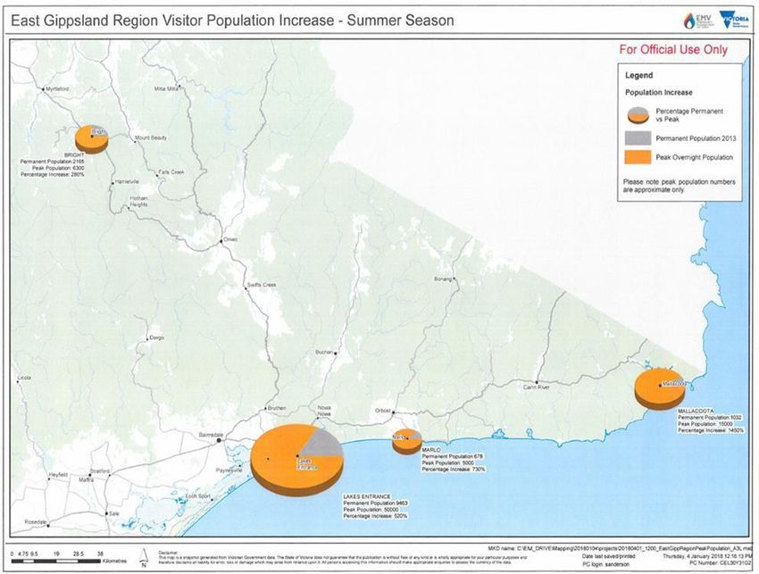
East (Gippsland) Region Emergency Response Plan – Storm
Complementary Plan Certification
The East (Gippsland) Region Emergency Response Plan – Storm Complementary Plan deals with
response to storm incidents within East (Gippsland) area of responsibility.

The following plan is intended to provide the framework for East (Gippsland) Region to effectively and
efficiently respond to future emergencies caused by storm, and will remain current until rescinded by
authority of the Victoria State Emergency Service Chief Officer Operations.

                                                                     Date: 22 April 2022
Tim Wiebusch
Chief Officer Operations

This plan is produced by Victoria State Emergency Service and has been adapted from the State
Emergency Response Plan – Storm Sub-plan. All information contained in this plan was current at time
of publication.

The Victoria State Emergency Service would like to acknowledge the significant contribution of key
stakeholders to ensure the content contained within this plan is of a high quality to support response
activities.

For further details about this plan, please contact East (Gippsland) Region:

Regional Manager – East (Gippsland) Region
Victoria State Emergency Service
130 Macleod Street, Bairnsdale Victoria 3875
Email: east@ses.vic.gov.au
Website: www.ses.vic.gov.au

East (Gippsland) Storm Complementary Plan                             Version 1.9 – April 2022   3
State Emergency Management Priorities
The State Emergency Management Priorities are:

    ▪   Protection and preservation of life is paramount. This includes:
           ▪ Safety of emergency response personnel
           ▪ Safety of community members including vulnerable community members and
               visitors/tourists
    ▪   Issuing of community information and community warnings detailing incident information that is
        timely, relevant and tailored to assist community members make informed decisions about their
        safety
    ▪   Protection of critical infrastructure and community assets that support community resilience
    ▪   Protection of residential property as a place of primary residence
    ▪   Protection of assets supporting individual livelihoods and economic production that supports
        individual and community financial sustainability
    ▪   Protection of environmental and conservation assets that considers the cultural, biodiversity, and
        social values of the environment.

East (Gippsland) Storm Complementary Plan                              Version 1.9 – April 2022   4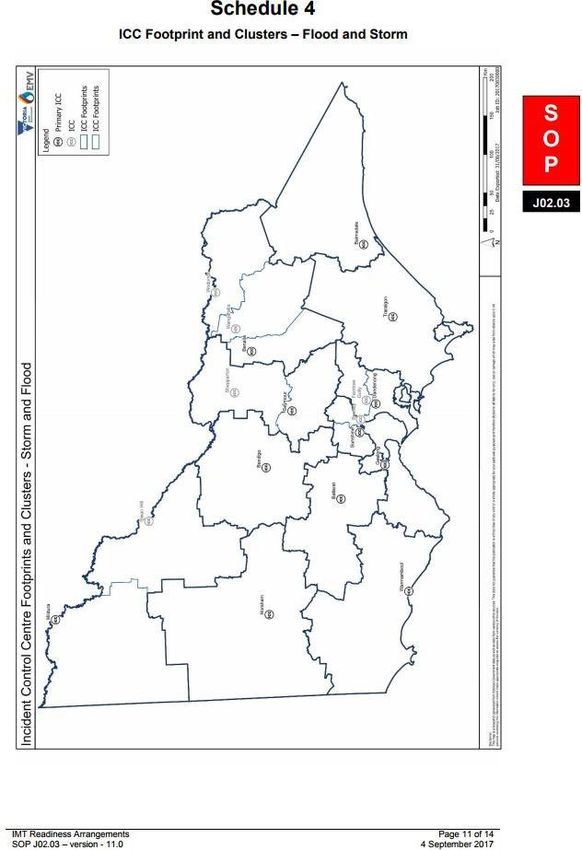
Table of Contents
1.   Introduction                                                                                                                                                  7

      1.1       Purpose .......................................................................................................................................... 7

      1.2       Objective ......................................................................................................................................... 7

      1.3       Scope.............................................................................................................................................. 7

      1.4       Authorising Environment ................................................................................................................. 7

      1.5       Activation of the Plan ...................................................................................................................... 8

      1.6       Audience ......................................................................................................................................... 8

      1.7       Linkages ......................................................................................................................................... 8

      1.8       Exercising and Evaluation ............................................................................................................... 8

      1.9       Review ............................................................................................................................................ 8

2.   The Storm Risk within the East (Gippsland) Region .................................................................................... 9

      2.1       Region Description .......................................................................................................................... 9

      2.2       The Storm Hazard ........................................................................................................................ 11

      2.2.1 Severe Weather and Severe Thunderstorm.................................................................................. 12

      2.3       Regional Resources...................................................................................................................... 12

3.   Consequences .......................................................................................................................................... 13

      3.1       Possible Storm Consequences ..................................................................................................... 13

      3.2       Storm History ................................................................................................................................ 13

4.   Community Resilience............................................................................................................................... 14

      4.1       Shared and Individual Responsibility for Action ............................................................................ 14

      4.2       Forecasting and Warning Services ............................................................................................... 15

      4.2.1 Forecasting Services .................................................................................................................... 15

      4.3       Municipal Storm Emergency Planning .......................................................................................... 16

      4.4       Community Engagement............................................................................................................... 16

      4.5       Household and Business Plans .................................................................................................... 16

      4.6       Community Safety Advice ............................................................................................................. 16

5.   Managing a Storm Event ........................................................................................................................... 17

      5.1       Roles and Responsibilities ............................................................................................................ 17

     East (Gippsland) Storm Complementary Plan                                                           Version 1.9 – April 2022           5
5.2 Concept of Operations .................................................................................................................. 17
5.3 Escalation and Notification ............................................................................................................ 17
5.4 Strategic Response Plan .............................................................................................................. 17
5.5 Cross Border Arrangements ......................................................................................................... 18
5.6 Regional Control Centre ............................................................................................................... 18
5.7 Incident Control Centres ............................................................................................................... 18
5.8 Divisional Command Points/ Field Operations Vehicle (FOV) ...................................................... 19
5.9 Regional Resource Requirements ................................................................................................ 19
Attachment 1 – Region Storm Scenarios .............................................................................................................. 21
Attachment 2 – East (Gippsland) Resource List.................................................................................................... 24
Attachment 3 – East (Gippsland) – Unit Map ........................................................................................................ 27
Attachment 4 – East (Gippsland) ICC Footprint – Flood & Storm ......................................................................... 28
Attachment 5 – East (Gippsland) VICSES unit list ................................................................................................ 29
Attachment 6 - Agency Contact Details ................................................................................................................. 30
East (Gippsland) Storm Complementary Plan Version 1.9 – April 2022 61. Introduction
1.1 Purpose
The purpose of this plan is to provide strategic guidance for the effective emergency management of storm
impacts in the East (Gippsland) Region.
1.2 Objective
The objective of the East (Gippsland) Region Emergency Response Plan – Storm Complementary
Plan is to outline the arrangements to ensure an integrated and coordinated approach to the management
of storm events across East (Gippsland) Region, in order to reduce the impact and consequences of these
events on the community, infrastructure and services.
1.3 Scope
This East (Gippsland) Region Emergency Response Plan – Storm Complementary Plan includes:
▪ Description of potential risks and consequences of storms to the social, built, economic and natural
environments within the East (Gippsland) Region.
▪ Region specific emergency management arrangements for the management of storms.
▪ Links to sources of information where the reader can obtain further detail.
1.4 Authorising Environment
The Emergency Management Act (1986 and 2013) and the Emergency Management Legislation
Amendment Act 2018 (EMLA Act 2018) is the empowering legislation for the management of emergencies
in Victoria.
The State Emergency Management Plan (SEMP) contains policy and planning documents for
emergency management in Victoria and provides details about the roles different organisations play in the
emergency management arrangements.
The SEMP also identifies Victoria’s organisational arrangements for managing the response to
emergencies as outlined in the Roles and Responsibilities Section.
The East (Gippsland) Region Emergency Response Plan (yet to be developed) will detail specific
arrangements for the management of emergencies within the East (Gippsland) Region. This plan has
been developed as a subordinate plan of the East (Gippsland) Region Emergency Response Plan and
the State Emergency Management Plan – Storm Sub-plan. This plan has been shared with the
Regional Emergency Management Committee for comment and approved by the VICSES Chief Officer
Operations.
Other relevant legislation includes:
▪ Victoria State Emergency Service Act 2005
▪ Essential Services Act 1958
▪ Planning and Environment Act 1989
▪ Local Government Act 1989
▪ Alpine Resorts (Management) Act 1997
East (Gippsland) Storm Complementary Plan Version 1.9 – April 2022 71.5 Activation of the Plan
The arrangements in this plan apply on a continuing basis and do not require activation.
1.6 Audience
The audience for this plan comprises the Victorian Government and agencies within the emergency
management sector, including business and community groups with a significant role in the management
of the emergency.
Although the wider community is not the primary audience, community members may find the contents of
this plan informative.
1.7 Linkages
This plan is a complementary plan of the State Emergency Response Plan – Storm Sub-plan and the
East (Gippsland) Region Emergency Response Plan (yet to be developed). It reflects legislation, the
arrangements in the State Emergency Response Plan, the strategic direction for emergency
management in Victoria and the accepted State practice for managing emergencies.
It is likely that storm events will include severe flooding, flash flooding and storm surge for areas prone to
coastal flooding. For arrangements for the management of flooding, refer to the State Emergency
Response Plan – Flood Sub-plan and East (Gippsland) Region Flood Complementary Plan at
www.ses.vic.gov.au.
While uncommon, Thunderstorm Asthma may also be associated with storm events as a result of high
pollen counts and higher than normal levels of humidity. Thunderstorm Asthma arrangements are
currently under development by the Department of Health and Human Services (DHHS) and the
Environmental Protection Agency (EPA).
Arrangements in this plan have not been repeated from afore mentioned plans, unless necessary to
ensure context and readability. All available Victoria State Emergency Service Plans can be accessed at
www.ses.vic.gov.au.
Arrangements for the management of secondary consequences are contained in the following:
▪ For health response – State Health Emergency Response Plan (SHERP)
▪ For rescue – the Victorian Urban Search and Rescue Response Arrangement (USAR)
▪ Flood response – State Emergency Response Plan – Flood Sub-plan, and East
(Gippsland) Region Emergency Response Plan – Flood Complementary Plan.
1.8 Exercising and Evaluation
This plan will be exercised within one year from the date of approval and once every three years thereafter
as part of a phased cycle. A Region Storm Scenario has been created to support this function available in
Attachment 1 – Region Storm Scenario. The exercise will be evaluated and, where improvements to the
emergency management arrangements in this plan are required, the plan will be amended and a revised
version issued. Exercises will be conducted in accordance with the State Exercising Framework.
Any operational activity in East (Gippsland) Region requiring the management of a storm event will be
regarded as exercising of the plan. The event is to be evaluated and reviewed, as outlined above.
1.9 Review
This plan was current at the time of publication and remains in effect until modified, superseded or
withdrawn.
East (Gippsland) Storm Complementary Plan Version 1.9 – April 2022 8This plan will be reviewed and updated every three years. Consideration will be given to an earlier revision
if the plan has been applied in a major emergency or exercise, or following a substantial change to the
relevant legislation or arrangements.
2. The Storm Risk within the East (Gippsland) Region
2.1 Region Description
Gippsland is a rural region of Victoria located in the south-eastern part of the state. It covers an area of
41,5561 square kilometres and lies to the east of Melbourne. Gippsland is comprised of seven
municipalities being Baw Baw, Bass Coast, South Gippsland, Wellington, East Gippsland, Latrobe, and
Southern Alpine Resort Management Board (Mt Baw Baw).
Gippsland has a variable climate, typified by periods of wet and dry conditions. Weather can be influenced
by the north/south movement of strong westerly winds and their associated cold fronts. A shift northwards
results in more storms over southern Australia.
Climate change predictions indicate drier and hotter conditions in southern Victoria. There is also a
prediction of an increase in the frequency and intensity of storm events.
The Gippsland coastline is vulnerable to coastal inundation during significantly high tides, particularly
when in conjunction with storm surges. The severity of impacts varies depending on factors including
geomorphology, estuary characteristics and population and infrastructure inundated. In addition, the
impact of individual meteorological events on flooding can vary due to precedent conditions and the
direction and severity of weather conditions
Gippsland has an estimated population of 271,2692, with the principal population centres being
Traralgon, Moe, Wonthaggi, Warragul, Morwell, Sale, Bairnsdale, Drouin, Leongatha, and Phillip Island.
There are many more remote areas in Gippsland containing smaller, more isolated communities that are
far away from regional centres.
Gippsland is best known for its primary production such as mining, power generation and farming as well
as its tourist destinations that include – International events such as the motorcycle grand prix held at
Phillip Island, Wilsons Promontory, the Gippsland Lakes, Walhalla, the Baw Baw Plateau and the
Strzelecki Ranges to name a few.
Tourism is an important industry for Gippsland. The region received over 5.4 million domestic (overnight
and daytrip) and international overnight visitors combined, who spent an estimated $872 million in the year
ending December 2017.
Major storms typically occur in Gippsland from October through to March, which is during the regions peak
tourist season. There would been major economic impacts and additional complications with vastly
exceeded local populations. Emergency Management Victoria (EMV) estimates for peak visitor and
permanent resident population totals and maps are listed below.
1
Australian Bureau of Statistics (ABS), Census 2016 http://www.abs.gov.au/census.
2
Australian Bureau of Statistics (ABS), Census 2016 http://www.abs.gov.au/census.
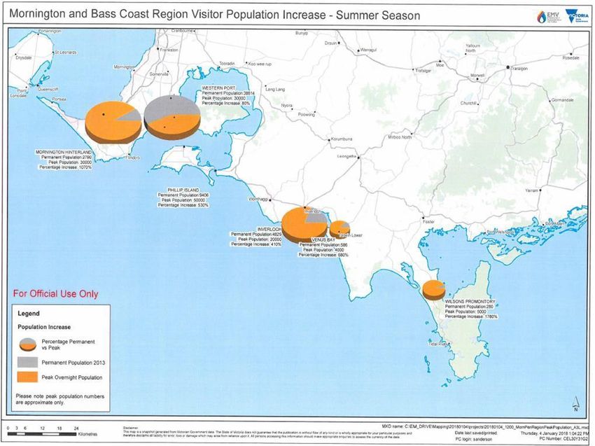
East (Gippsland) Storm Complementary Plan Version 1.9 – April 2022 9Bass Coast • Inverloch permanent population 4,829 – peak 20,000 - 410% increase • Phillip Island permanent population 9,406 – Peak 50,000 - 530% increase • Venus Bay permanent population 586 – peak 4,000 - 680% increase South Gippsland • Wilson’s Promontory - permanent population 280 – peak 5,000 – 1,780% increase East (Gippsland) Storm Complementary Plan Version 1.9 – April 2022 10
East Gippsland

      •   Lakes Entrance - permanent population 9,463 – peak 50,000 - 520% increase

      •   Marlo - permanent population 678 – peak 5,000 - 730% increase

      •   Mallacoota - permanent population 1,032 – peak 15,000 - 1,450% increase

2.2       The Storm Hazard
Storms in the context of this plan include wind storms, dust storms, Tornadoes, snow storms, blizzards,
hail storms and severe thunderstorms including hail storms and heavy rain leading to flash flooding.

Severe weather events affecting land-based communities are generally divided into two broad categories:
      ▪   Thunderstorm events
      ▪   Other severe weather events not directly associated with severe thunderstorms, tropical cyclones
          or bushfires.

Warnings are issued by the Bureau of Meteorology for weather events that may produce severe
phenomena.

 East (Gippsland) Storm Complementary Plan                           Version 1.9 – April 2022   11
2.2.1 Severe Weather and Severe Thunderstorm
The Bureau of Meteorology (BoM) issues two types of warnings.
A Severe Weather warning is issued for potentially hazardous or dangerous weather that is not solely
related to severe thunderstorms, tropical cyclones or bushfires.
These types of severe weather hazards include damaging or destructive winds, heavy rain, abnormally
high tides, damaging waves and blizzards in Alpine areas.
A Severe Thunderstorm is defined by the Bureau of Meteorology as one that produces any of the following:
▪ Hailstones with a diameter of 2cm or more
▪ Wind gusts of 90km/h or greater
▪ Flash flooding
▪ Tornadoes.
A severe thunderstorm may be exceeded by a very dangerous thunderstorm, defined as one that
produces hailstones with a diameter of 5cm or more and/or wind gusts of 125km/h or greater.
The types of hazardous phenomena associated to severe weather include land gales and squalls, heavy
rain leading to flash flooding and blizzards.
A table detailing the criteria for issuing severe thunderstorm warnings and severe weather warnings is
contained in the State Emergency Response Plan – Storm Sub-plan.
2.3 Regional Resources
VICSES Resource processes are set out in the ‘VICSES Operations Management Manual’.
Regional Resources remain under the command of the Regional Agency Commander until they arrive at
the incident.
Key regional resources that are used for storm response include:
• Attachment 2 - VICSES Regional Resource List
• Attachment 3 - VICSES Unit Map
• Attachment 5 - VICSES East (Gippsland) unit list
Additional specialised multi-agency resources may be accessed during operations through the
Australasian Inter-Service Incident Management System (AIIMS) structure. These resources are
requested via the State Resource Request System.
VICSES General Response Boundaries Map and are accessible via Emergency Management – Common
Operating Picture (EM-COP) for registered users.
East (Gippsland) Storm Complementary Plan Version 1.9 – April 2022 123. Consequences
3.1 Possible Storm Consequences
The East (Gippsland) Region has many communities prone to storm events, and the consequences of
these include:
▪ Loss of life or serious injury
▪ Damage to or loss of:
o Key infrastructure:
▪ Princes Hwy is a major transport route to the region and also NSW. Storms can
block roads delaying distribution of basic foods and perishable items.
▪ The rail network connects Melbourne to East Gippsland
▪ Public buildings in major regional centres can be affected with the loss of power
impacting individuals and communities that rely on access to support services.
o Essential services:
▪ Power generated in the region is distributed to metropolitan Melbourne and
interstate. The loss of transmission infrastructure would reduce the output of these
facilities with the potential to impact tens of thousands of residents through
blackouts.
▪ Water, sewerage, gas, telecommunications
o Private property:
▪ The impacts of private property as a result of a Strom event can be loss of parts or
total destruction habitable areas of the houses, forcing relocation in the short or
long term.
o Industry / business:
▪ The loss of transportation access can impact the ability of businesses to be able to
continue to trade resulting in economic impacts, potential short or long term loss of
employment.
o Agriculture – crop and livestock
▪ Storms have been shown to devastate any crops that have been sown, with the
flow of loss of feed for livestock. Whilst the storm may be short term i.e. less than a
few days the economic impacts to farmers may not be evident for months.
▪ Damage to the environment.
▪ Damaging winds, heavy rains can lead to erosion in sensitive environmental areas.
Information on building critical infrastructure resilience can be found in the State Emergency Response
Plan – Storm Sub-plan. This is supported by the Victorian Critical Infrastructure Resilience Strategy
available at www.emv.vic.gov.au/our-work/critical-infrastructure-resilience.
3.2 Storm History
The table below provides summary of five historical storms within the East (Gippsland) Region in the past
twenty (20) years.
A comprehensive list of storm events during 1900 to 2016 is available on the Bureau of Meteorology
Archives - via http://www.bom.gov.au/australia/stormarchive/
East (Gippsland) Storm Complementary Plan Version 1.9 – April 2022 13Date Locality Impacted Consequences
Reports of considerable damage to houses and outbuildings as a result
heavy rainfalls leading to flash flooding.
Water levels rose quickly in the local Creek which broke its banks. Water
Feb - 2012 Buchan Caves flowed through the Buchan Caves carpark and Cave system damaging
infrastructure, private and public property, roads and bridge abutments.
There were reports of a large number of trees that sustained noticeable
damage in the area.
Verandah blown off with extensive tree damage resulting in multiple road
closures. Power outages for a number of hours.
Winds gusts of 101-102 km/h were recorded in the area.
Jan – 2009 Orbost
The path of the damaging winds followed a straight line with a small tornado
reported at Orbost.
Severe thunderstorms produced flash flood in areas or Melbourne and
Leongatha.
Toongabbie
Dec - 2007 Leongatha Loch A tornado twisted trees in the Loch which needed to be removed from
major roads and properties
Severe thunderstorms with high winds of up to 100 km/h uprooted and
damaged many trees in the area.
Houses were damaged with tiled roofs sustaining damaged and buildings
Jan - 2006 Boolara
damaged by rains and some have water inundation from flash flooding.
Farm fences and outbuildings were also damaged by winds and debris.
More than 21 local roads were blocked by fallen trees.
A cold front passed through southern Victoria producing squalls, severe
wind gusts were also recorded at Wilson's Prom 107 Km/h, Sale 100 km/h
and Bairnsdale 104 km/h
Sept - 2000 Warragul
Hail smaller than a 5 cent piece was also reported.
Wind damage to buildings and trees occurred around Warragul.
4. Community Resilience
4.1 Shared and Individual Responsibility for Action
The National Strategy for Disaster Resilience and VICSES Community Resilience Strategy together
provide high level guidance on disaster management for our people, providing examples on how we can
work together to build safer and more resilient communities.
Together this can be done by building capacity, increasing collaboration and fostering connections.
Foremost is the principle of society taking responsibility for preparing for disasters. The role of the
community in disasters is based on individuals taking their share of the responsibility for preventing,
preparing for, responding to and recovering from disasters. Examples in the context of storms include:
▪ Individuals being aware of their storm risk, and following advice from emergency services when
responding to warnings
East (Gippsland) Storm Complementary Plan Version 1.9 – April 2022 14▪ Local governments and communities including storm risk within their Community Emergency Risk
Assessment (CERA) activities, including consideration within emergency management planning
and land use planning
▪ Industry and businesses planning for the risk of disruption, and ensuring arrangements are in place
to maintain critical services, and assist communities where possible
▪ Government agencies undertaking:
▪ Risk assessments to gain an appreciation of storm risk
▪ Engaging with the community regarding storm risk
▪ Working with communities to plan the management of storm risk
▪ Providing emergency information and storm warnings
▪ Ensuring an effective, well-coordinated response during storms
▪ Helping communities to recover and learn following a storm and to build their resilience to
future events.
We therefore recognise the importance of working in partnership with communities. When communities
play a role in their own safety, resilience is enhanced. The benefits of building community resilience and
investing in disaster preparedness (disaster risk reduction – DRR) initiatives include:
▪ Safer communities
▪ Less demands on emergency services for assistance
▪ Less damage to property and infrastructure
▪ Speedier recovery
▪ Reduction in overall (impact and recovery) costs to the national economy
▪ Increase capacity and capability across the board
The East (Gippsland) Region has developed and delivers a range of programs to achieve the goals
outlined in the VICSES Community Resilience Strategy and delivers programs to at-risk communities to
provide information on what to do before, during and after storms. More information can be found in
section 4.4 Community Engagement and at www.ses.vic.gov.au/plan-and-stay-safe.
4.2 Forecasting and Warning Services
4.2.1 Forecasting Services
The Bureau of Meteorology has a requirement under the Meteorology Act 1955 to warn the community and
provide the following services to the Victoria State Emergency Service. These services are outlined in
detail in the State Emergency Response Plan – Storm Sub-plan:
▪ Severe Weather Intelligence Briefing – five-day outlook
▪ Severe Thunderstorm Forecast Chart – thunderstorm forecast issued at 11:30am each day
indicating the chance of thunderstorms (outside storm season). A Day 2 forecast will usually be
issued at midday during “thunderstorm season” (October to April)
▪ Severe Weather Warnings – Issued when severe weather is expected to affect land-based
communities within 6-24 hours and one or more of the following applies:
▪ it is not directly the result of severe thunderstorms
▪ it is not covered by tropical cyclone or fire weather warnings
▪ Severe Weather is already occurring and a warning is not already current
East (Gippsland) Storm Complementary Plan Version 1.9 – April 2022 15▪ Severe Thunderstorm Warning – Issued whenever there is sufficient meteorological evidence to
suggest that severe thunderstorm development is likely, or when a severe thunderstorm has
already developed and a warning is not already current.
4.3 Municipal Storm Emergency Planning
Where storms are identified through the emergency risk management process as a high priority to a
community, the Victoria State Emergency Service will provide advice and support to the Municipal
Emergency Management Planning Committee (MEMPC) to ensure the Municipal Emergency
Management Plan (MEMP) contains at a minimum, arrangements for the response to a storm event based
on all-hazards and all-agency response.
4.4 Community Engagement
Community engagement programs to build community resilience for storm are conducted in accordance
with the VICSES Community Resilience Strategy, as outlined in section 4.1 Shared and Individual
Responsibility for Action.
The East (Gippsland) Region community engagement Storm Safe strategy involves, but is not limited to:
▪ Community Education Awareness sessions are provided to general VICSES volunteers.
▪ Participation in community led emergency planning and multi-agency activities including municipal
storm education responsibilities.
▪ Community Education Facilitator (CEF) courses are conducted to equip specialist volunteers with
the required tools, skills and knowledge to build storm awareness in their local communities.
▪ Endorsed CEF’s from across the region come together to form a Community Education Advisory
Group (CEAG) where they support and share ideas on activities used to engage with their
community.
▪ Regular unit activities and events to reinforce the storm and severe weather event risk messaging.
▪ Building resilience and capacity within communities, for example, effective preparation of
properties, response during and after storm events.
4.5 Household and Business Plans
The VICSES advises that every household and business should have written emergency plans.
Information on the development of household and business plans can be found at
www.ses.vic.gov.au/plan-and-stay-safe.
4.6 Community Safety Advice
Victoria State Emergency Service provides advice to communities in the form of key safety messages for
storm including advice for safe evacuation. A full list of community safety advice messages can be viewed
online via EM-COP, located in the IMT Toolbox and VICSES public website.
East (Gippsland) Storm Complementary Plan Version 1.9 – April 2022 165. Managing a Storm Event
5.1 Roles and Responsibilities
Roles and responsibilities of agencies involved in responding to storms are detailed in the State
Emergency Response Plan – Storm Sub-plan.
5.2 Concept of Operations
The concepts of operations for responding to storm are detailed in the State Emergency Response Plan
– Storm Sub-plan.
5.3 Escalation and Notification
The Bureau of Meteorology publishes Severe Weather and Severe Thunderstorm Warnings, as detailed in
section 4.2 Storm Forecast and Warning Service, on their public website www.bom.gov.au and provides
them to pre-identified agencies, organisations and media outlets, including pager and email warning
messages to Victoria State Emergency Service at the State and Regional Level.
Upon receipt of a Severe Weather or Severe Thunderstorm Warning, Regional Duty Officers (RDOs) will
acknowledge the pager message.
The escalation and notification process for storm response is operationalised within the Victoria State
Emergency Service Standard Operating Procedure (SOP) 008 – Severe Weather Notification and
Activation Process.
Once the levels are met the Regional Duty Officers will notify the Regional Agency Commander (RAC) to
notify the Regional Controller and/or Regional Emergency Management Team members for storm
response, and any relevant Units.
5.4 Strategic Response Plan
The actions listed below are the responsibility of Victoria State Emergency Service at the Regional and
State tiers. Responsibility for these actions may transition to the Regional Controller to support
multi-agency response when significant impacts caused by a storm event occur. Associated storm
readiness levels and ICC footprints can be located within JSOP 2.03 Incident Management Team (IMT)
Readiness Arrangements or the VICSES Storm Readiness and Activation Trigger Considerations (v3.0),
also available via Attachment 4 – IMT Readiness Levels – Storm or on EM-Cop.
On receipt of advice from the Bureau of Meteorology of the potential for storm activity, the RAC will
undertake strategic level planning in anticipation of an event, in alignment with Victoria State Emergency
Service severe weather triggers. Key considerations will include:
▪ Establishing the control structure for managing the event
▪ Supporting consistent emergency warnings and provision of information to the community
▪ Preparations for possible evacuations including implementation of evacuation and emergency
relief plans and identification of evacuation points
▪ Confirming agencies at all tiers are activated and appropriate arrangements are in place
▪ Identifying the likely consequences of the storm event and any interdependencies that may affect
planning
▪ Confirming agencies have adequate resources in place to fulfil their responsibilities and are
planning for sustainment and surge capacity, including identification of need for inter-state
assistance
East (Gippsland) Storm Complementary Plan Version 1.9 – April 2022 17▪ Identifying mass gatherings and large public events that may be at risk, and arrangements to
ensure the safety of individuals attending
▪ Confirming agencies with call-taking responsibilities have resources in place and backup
arrangements to cope with the expected call load
▪ Positioning of Emergency Management Liaison Officers (EMLOs) from key support agencies to
Regional Control Centres (RCCs), where appropriate
▪ Arranging for regular meetings of the Regional Emergency Management Teams (REMTs) and
Incident Emergency Management Teams (IEMTs)
▪ Providing situation reports to the State Control Team (SCT).
5.5 Cross Border Arrangements
For the East (Gippsland) Region, cross border arrangements exist with NSW SES, supported by a
Memorandum of Understanding (MoU) that outlines how VICSES will request assistance from the NSW
SES.
5.6 Regional Control Centre
The Regional Response Plan outlines pre-determined facilities that are suitable for the establishment of a
Regional Control Centre (RCC) for the management of emergency events, including for storm flood
response, in East (Gippsland) Region. The RCC for East (Gippsland) is located at:
Gippsland Region
Level 1, 181 Franklin Street, Traralgon, 3844
Phone: 03 5177 3240
Fax: 03 5177 3284
E: rccgip.all@rcc.vic.gov.au
5.7 Incident Control Centres
The Regional Response Plan outlines pre-determined Incident Control Centre (ICC) locations in the East
(Gippsland) Region for emergency response, including storm and flood response.
Additional ICC’s are available within the region and will be activated when agreed upon by the Regional
Controller and VICSES Regional Agency Controller (RAC) dependant on the location and scale of the
storm event.
The activation of the ICCs will be in line with the readiness arrangements outlined in JSOP 2.03 or the
VICSES Storm Readiness and Activation Trigger Considerations (v11.0); refer to Attachment 8 – IMT
Readiness Levels – Storm.
Name Agency Location
Bairnsdale DELWP 574 Main Street, Bairnsdale
Traralgon DELWP Level 2, 181 Franklin Street, Traralgon
A map of agreed ICC footprints is available online via EM-COP – refer to schedule 4 – JSOP2.03
East (Gippsland) Storm Complementary Plan Version 1.9 – April 2022 185.8 Divisional Command Points/ Field Operations Vehicle (FOV)
VICSES facilities equipped as Divisional Command Points (DCPs) are listed in table below. (Subject to
review)
Location Address Agency
Bairnsdale Unit 189 Macleod Street, Bairnsdale VICSES
Sale Unit 35-37 Union Street, Sale VICSES
Moe Unit 265 Monash Road, Newborough VICSES
Yarram Unit 50 Railway Avenue, Yarram VICSES
Further facilities suitable for storms are available from other agencies.
CFA Facilities are referred to as Local Command Facilities (LCFs) they are equipped to VICSES DCP
standard. Refer to Attachment 4 – Municipal Flood Emergency Plans and Local Flood Guides for individual
MFEPs likely to be used.
Where fixed Command and Control Facilities are not available or appropriate to operational conditions, a
mobile facility may be deployed to enable an Incident Controller or Commander to manage the incident.
5.9 Regional Resource Requirements
Resources listed below are those that would be required at the peak of an event, and would represent the
resources of all agencies with responsibilities under the State Emergency Response Plan – Flood
Sub-plan.
Agency Resources
Swift Water Rescue Team – Available via Rescue Coordination
Centre (RCC)
Traffic Management
Victoria Police Evacuation Management
Chain Saw Operators – Trim and Cross Cut
Sand Bag Crews
Ground Observers – (Initial impact Assessment)
IMT Roles
CFA Ladder Platform – Specialist Access
Chain Saw Operators / Tree fallers
Sand Bag Crews
Fire Rescue Victoria Impact Assessment
(FRV)
Department of IMT Roles
Environment, Land,
Water and Planning Recovery
(DELWP)
Plant
Chain Saw Operators / Arborists
Local Government
Traffic Management
East (Gippsland) Storm Complementary Plan Version 1.9 – April 2022 19Department of Health Relief and Recovery
(DoH)
Department of Assistance with labour for Sandbagging crews
Justice (DoJ)
VICSES & CFA East Gippsland - Technical rescue teams
Chain Saw Operators / Arborists
VicRoads
Traffic Management
East (Gippsland) Storm Complementary Plan Version 1.9 – April 2022 20Attachment 1 – Region Storm Scenarios Region storm scenarios have been developed to support periodic training requirements (outlined in section 1.8) and to provide opportunity to document anecdotal and/or known storm impacts based on historic events. The below scenarios are based on Storm scenarios of varying intensity. Scenario 1 – Gippsland Storm Event – March 2011 Weather System During March 2011, the Gippsland area was experiencing warmer than normal overnight low temperatures. Gippsland Catchments had recorded higher than normal rainfall totals 150% of average monthly totals in West Gippsland and 270% East Gippsland. On Tuesday March 22nd the BoM issued a Flood Watch for West and South Gippsland (Latrobe, Thomson, Macalister and Avon Catchments and South Gippsland Basin) In the 24 hours to 9 AM Tuesday rainfall totals of up to 36mm have been recorded in the West and South Gippsland catchments. Due to the slow moving nature of the low pressure system combined with high moisture levels in the atmosphere, isolated rainfall totals of in excess of 50mm in a 6 hour period are possible in the coming days across this region. Forecast Bureau of Meteorology (BoM) forecast a broad area of low pressure that will persist near Victoria with a low pressure system developing to the south of the State tonight. The low is expected to be slow moving during Wednesday before moving south eastwards across Tasmania and deepening on Thursday. Stream rises have been observed in the upper catchments; however this has not developed into flooding. If widespread rainfall in excess of 50mm is recorded across the West and South Gippsland catchments, significant stream rises and areas of flooding may develop over the coming days. A low pressure system and associated trough over north-western Victoria will drift slowly south-eastwards today. The low will then drift westwards to be south of Mt Gambier by late Tuesday. The low is expected to be slow moving during Wednesday before moving south-eastwards and deepening on Thursday. A strong wind warning for Victorian waters between Cape Otway and 60nm east of Gabo Island. Event Vic SES received a number of calls of flooding to buildings and roads around the Tidal River Campsite located at Wilson’s Promontory National Park in South Gippsland. These included calls to rescue people trapped by rising floodwaters which were allocated to the local SES unit located in Foster. In the previous 24 hours Wilson’s Promontory reported 370mm of rain at Tidal River. Consequences Isolation Approximately 400 visitors, staff and local VICSES Crews in the area were unable to leave due to the loss of the single access and egress road with the loss of the bridge at Darby River. Visitors were later airlifted with the use of helicopters that were in Gippsland for Fire support over the summer period. They were taken to a local airfield at Yanakie and then transported in buses via unaffected roads to the Foster Football ground where a staging area had been established. Infrastructure ▪ Generators were damaged and the loss of power impacted the sewerage treatment plant. East (Gippsland) Storm Complementary Plan Version 1.9 – April 2022 21
▪   Roads undercut by erosion made vehicle movements hazardous requiring heavy machinery.
    ▪   Damaging winds uprooted trees on the road in and out of the Tidal River campsite. Landslides on
        sections of the road leading to Telegraph Saddle which is the starting point for many of the day and
        overnight walks in the area also prevented vehicles from accessing the area.
    ▪   Walking tracks were damaged.

Personal property losses include:
   ▪ Significant water damage to caravans, tents, cars.
    ▪   Personal belongings.

Recovery
There was an economic impact with the closure to the park for months so that repairs to the bridge could
be completed. This enabled vehicles and personal belongings to be recovered.

Tidal river campsite cabins were severely damaged and have since been rebuilt.

The cost to the government to rebuild the infrastructure was $9 million dollars. This does not include
individual insurance claims.

East (Gippsland) Storm Complementary Plan                            Version 1.9 – April 2022   22
Scenario 2 – Gippsland Storm June 2012
In early June 2012, an extensive band of rain and damaging winds developed across the Gippsland area.
Gippsland water catchments had received above average rainfall with saturated catchments which
impacted the soils ability to absorb more water.
Forecast
The BoM advised VICSES that a storm cell was expected to develop on Monday 4th of June with the
potential for damaging gusts to around 100km/hr along the coast and rainfall totals of up to 100mm are also
likely over Gippsland and on the ranges for a 48 hour period. Flood Watches were issued for East
Gippsland and West & South Gippsland during the afternoon.
On Monday morning VICSES was advised that wind speeds had increased and rainfall totals increased
from 100mm up to 150mm amounts had increased and that 80-120mm was possible through central and
eastern Gippsland with peak totals about the ranges of around 150mm.
Event
Strong winds developed along the coast and at elevated locations in the Gippsland with a 144km/hr gust
recorded at Mt Buller and 120km/hr at Gabo Island.
Damaging winds and saturated soil levels resulted in trees being brought down, buildings damaged and
flash flooding across the region with major impacts in Traralgon South area surrounding Traralgon Creek.
Gippsland received significant rainfall totals of between 150 -200mm in parts of central parts of Gippsland.
Numerous stations recorded up to twice the average monthly rainfall in just two days.
Consequences
Hundreds of trees fell as a result of the strong winds causing damage to properties. Roads were blocked
over 50 kilometres isolating transport vehicles.
VICSES received 722 Request for Assistance (RFA’s) across Gippsland in the 48 hour period. Morwell
and Moe recorded the majority of building damage due to water entering buildings.
Isolation
There were also 33 rescue events involving persons trapped or stranded by floodwaters after trying to
drive through flood waters.
Infrastructure
▪ Bridges, roads and recreational areas were damaged in the Latrobe, Wellington and East
Gippsland Shires.
▪ Powerlines and communications services in East Gippsland.
Personal
▪ 1,500 farmers impacted with crop losses
▪ Homes were damaged with water inundation
▪ Small businesses suffered economic losses particularly in the tourist areas.
East (Gippsland) Storm Complementary Plan Version 1.9 – April 2022 23Attachment 2 – East (Gippsland) Resource List
The table below outlines the resources available for response held by East Region VICSES units.
Unit Primary Support 4WDs Boats Trailers Lighting
Name Vehicle/s Vehicle/s Towers
Bairnsdale Primary Storm/ 4WD x 2 Rescue Boat – 5.0 Storm N/A
Rescue rescue Gemini RIB Trailer
(heavy) support
Rescue Boat – 4.7
Jabiru
Bruthen Ranger Storm/ 4WD x 1 N/A Storm Light
4WD rescue Trailer Tower
support
Bendoc Primary Storm/ 4WD N/A N/A N/A
Rescue rescue
(Medium) support
Buchan Primary Storm/ 4WD N/A Storm N/A
Rescue (6- rescue Trailer –
wheel drive support (Due Mid
medium) 2018
Cann Primary Storm/ 4WD x2 Rescue Boat – 3.8 N/A Light
River Rescue Rescue Quicksilver IRB Tower
(Medium) Support (Inflatable Rigid Hull)
Erica 4WD Storm/ 4WD N/A Storm Light
Rescue Trailer Tower
Support
Foster Primary Storm/ 4WD x2 Rescue Boat – 5.0 Storm Light
Rescue Rescue Zodiac RHIB Trailer Tower
(Medium) Support (Rigid Hull Inflatable
Boat)
Inverloch 4WD Twin Medium 4WD Off Shore Rescue N/A N/A
cab ute truck to tow Boat
boat 8.0 Stabicraft
&
Rescue Boat – 5.0
Zodiac RHIB
(Rigid Hull Inflatable
Boat)
Leongatha Primary Storm/ 4WD x 2 N/A N/A Light
Rescue Rescue Tower
(Heavy) Support
Loch Sport Ranger Storm/ 4WD x 1 Rescue Boat – 5.0 Storm N/A
4WD Rescue Gemini RIB Trailer
Support
East (Gippsland) Storm Complementary Plan Version 1.9 – April 2022 24Unit Primary Support 4WD’s Boats Trailers Storm
Name Vehicle(s) Vehicle(s) Trailers
Maffra Primary Storm/ 4WD x 2 N/A Storm N/A
Rescue Rescue Trailer
(6-wheel Support
drive
Medium)
Mallacoota Primary Storm/ 4WD Rescue Boat – 4.7 N/A N/A
Rescue Rescue Jabiru
(Medium) Support Rescue Boat – 4.0
Zodiac IRB
IRB (Inflatable Rigid
Hull)
Moe Primary Storm/ 4WD x 2 Rescue Boat – 4.2 Storm N/A
Rescue Rescue Gemini RIB Trailer
(Medium) Support
Morwell Primary Storm/ 4WD Rescue Boat – 5.2 N/A Light
Rescue Rescue Jabiru Tower
(Heavy) Support &
Rescue Boat – 5.0
Gemini RIB
Traralgon Primary Storm/ 4WD N/A Storm N/A
(Morwell Rescue Rescue Trailer
satellite) (Heavy) Support
Orbost Primary Storm/ 4WD Rescue Boat – 4.7 Storm N/A
Rescue Rescue Jabiru Trailer
(Heavy) Support
Phillip Primary Storm/ 4WD N/A Storm N/A
Island Rescue Rescue Trailer
(Heavy) support
Rosedale Primary Storm/ 4WD N/A Storm Light
Rescue Rescue Trailer Tower
(Heavy) Support
Sale Primary Storm/ 4WD x 2 Rescue Boat – 5.0 Storm N/A
Rescue Rescue Zodiac RHIB Trailer
(Heavy) Support (Rigid Hull Inflatable
Boat)
San Remo Primary Storm/ 4WD N/A N/A N/A
Rescue Rescue
(Heavy) Support
In addition to the unit resources listed above the following VICSES regional strategic resources and
composite teams are available.
▪ 1 x Field Operation Vehicle (Mobile Command Facility)
▪ Land Based Swift Water Rescue Crews – trained personnel exist within the Region and are subject
to availability.
▪ 1 x Logistics Truck (With staging area or base camp equipment)
East (Gippsland) Storm Complementary Plan Version 1.9 – April 2022 25Additional expert multi-agency resources may be accessed during operations through the Australasian Inter-Service Incident Management System (AIIMS) structure. This support is initiated/ accessed in the first instance by the VICSES RDO via the Regional Agency Commander (RAC) to the Gippsland Regional Emergency Management Team (REMT) East (Gippsland) Storm Complementary Plan Version 1.9 – April 2022 26
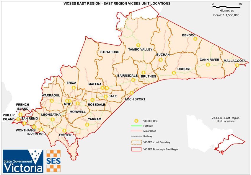
Attachment 3 – East (Gippsland) – Unit Map
VICSES Units within East (Gippsland) Region include:

▪   Bairnsdale                          ▪   Leongatha          ▪   San Remo
▪   Bendoc                              ▪   Loch Sport         ▪   Stratford
▪   Bruthen                             ▪   Maffra             ▪   Tambo Valley
▪   Buchan                              ▪   Mallacoota         ▪   Warragul
▪   East RECC Unit                      ▪   Moe                ▪   Wonthaggi
▪   East RHQ Support RSU                ▪   Morwell            ▪   Yarram
▪   Erica                               ▪   Orbost
▪   Foster                              ▪   Phillip Island
▪   Inverloch                           ▪   Sale

A map of VICSES Units within the East (Gippsland) Region is provided below. Further details are available
for registered users of EM COP.

East (Gippsland) Storm Complementary Plan                          Version 1.9 – April 2022   27
Attachment 4 – East (Gippsland) ICC Footprint – Flood & Storm
Further details on Storm readiness levels is available on EMCOP
https://files-em.em.vic.gov.au/public/JSOP/SOP-J02.03.pdf

East (Gippsland) Storm Complementary Plan                         Version 1.9 – April 2022   28
Attachment 5 – East (Gippsland) VICSES unit list
EAS - Contact number 1800 609 511ion Duty Officer – Capcode 30148

    Unit Name                         Address                                         Paging
                                                                                      Number
  Bairnsdale             189 McLeod Street, Bairnsdale Vic. 3875                       30095
  Bendoc                 Corner of James & Nichol Streets, Bendoc Vic. 3888            30099
  Bruthen                51 Main Street, Bruthen Vic. 3885                             30101
  Buchan                 32 Main Street. Buchan Vic. 3885                              30103
  Cann River             29 Monaro Hwy, Cann River Vic. 3890                           30105
  Erica                  1A Lehman Court, Rawson Vic. 3825                             30109
  ERHSU                  130 McLeod Street, Bairnsdale Vic. 3875                       30097
  Foster                 14 Pioneer Street, Foster Vic. 3960                           30111
  Inverloch              23 Bear Street, Inverloch Vic. 3996                           30113
  Leongatha              12 Watson Road, Leongatha Vic. 3953                           30115
  Loch Sport             105 National Parks Drive, Loch Sport 3851                     30117
  Maffra                 90 Landy Street, Maffra Vic. 3860                             30119
  Mallacoota             Lees Road, Mallacoota Vic. 3892                               30121
  Moe                    265 Monash Road, Moe Vic. 3825                                30123
  Morwell                75 Airfield Road, Traralgon West Vic. 3844                    30125
  Orbost                 5 Wolseley Street, Orbost Vic. 3888                           30127
  Phillip Island         125/127 Settlement Road, Cowes Vic. 3922                      30129
  Rosedale               47 Cansick Street, Rosedale Vic. 3847                         30131
  Sale                   37 Union Street, Sale Vic. 3850                               30133
  San Remo               14 Davis Point Road, San Remo Vic. 3925                       30135
  Stratford              53 Mac Farlane Street, Stratford Vic. 3862                    30137
  Tambo Valley           6870 Great Alpine Road, Swifts Creek Vic. 3896                30139
  Warragul               160 Queen Street, Warragul Vic. 3820                          30141
  Wonthaggi              319 White Street, South Dudley Vic. 3995                      30143
  Yarram                 50 Railway Ave, Yarram Vic. 3971                              30145

East (Gippsland) Storm Complementary Plan                       Version 1.9 – April 2022   29
Attachment 6 - Agency Contact Details
Emergency Management Contacts
Refer to EM-COP - Gippsland Contact Directory
VICSES Contacts
Refer to East (Gippsland) Unit Profiles
Other useful contacts
Business Details Phone Fax
Emergency Hotline (Radio Master Control)
ABC 1300 737 102
Ambulance Medical emergency 000
AUSLAN To book an interpreter service 1300 1300 287 526
AUSLAN or book online
https://auslanservices.com/
Country Fire Authority Fire 000
(CFA)
Agriculture Victoria Emergency Animal Disease Watch Hotline 1800 675 888
Agriculture Victoria Exotic plant pest hotline 1800 084 881
Department of Education Emergency Duty Officer 1300 333 232 1300 DEECD 2
& Training (DET)
Department of Customer Service Centre 13 61 86
Environment, Land,
Water and Planning
(DELWP)
Energy Safe Victoria Electrical Emergencies 1800 000 922
Energy Safe Victoria Gas Emergencies 132 771
Environment Protection Pollution Hotline 1300 372 842
Authority (EPA)
Emergency Services emergency call-taking and dispatch 03 8656 1200
Telecommunications
Authority (ESTA)
Fire Rescue Victoria Fire 000
(FRV)
Victorian Poisons Poisons information helpline 13 11 26
Information Centre (000 in an
(VPIC) emergency)
Victoria Police Emergency 000
131444
Public Transport 03 9027 4011
Crisis and Emergency Response 03 9027 4241 (facsimile)
Victoria (PTV)
Lifesaving General Enquiries and Life Saving General:
Victoria (LSV) Operations 03 9676 6900
Operations
03 9676 6930
(000 in an
emergency)
Transport Safety
Incident Reporting - passenger transport Rail Melbourne:
Victoria
East (Gippsland) Storm Complementary Plan Version 1.9 – April 2022 30and boating
1800 318 244
Bus:
1800 301 151
Maritime:
1800 135 729
Victorian Bushfire VicEmergency Hotline 1800 226 226
Information Line (VBIL)
VicFish Fisheries Offences 13 FISH 13 3474
VLine / VicRail 24/7 Duty Officer 188 800 007
VicRoads Emergencies and Road Closures 131 170
VICSES Requests for Flood or Storm 132 500
assistance
VICSES Life Threatening 000
VICSES Media Media enquiries and support 1300 783 933
VICSES Emergency Information Line 1300 842 737
Worksafe Incident Notification 13 23 60
VicEmergency VicEmergency Hotline 1800 226 226
East (Gippsland) Storm Complementary Plan Version 1.9 – April 2022 31You can also read