East Hagbourne NEIGHBOURHOOD DEVELOPMENT PLAN - Plan made - April 2019 - South Oxfordshire District Council
←
→
Page content transcription
If your browser does not render page correctly, please read the page content below
East Hagbourne
NEIGHBOURHOOD DEVELOPMENT PLAN -
          2018 to 2033

      Plan made – April 2019
                                                                  1
                                                                  Page

          East Hagbourne NP Made Version 07/2020   Page 1 of 76
Contents
1.     Introduction ............................................................................................................................................. 4
2.     The East Hagbourne Neighbourhood Plan ................................................................................... 4
     2.1      How the EH Neighbourhood Plan fits into the Planning System ................................. 5
     2.2      Designation....................................................................................................................................... 5
     2.3      Community engagement ............................................................................................................. 6
     2.4      Preparation of the Draft Plan .................................................................................................... 7
     2.5      Submission and Examination .................................................................................................... 8
3.     The Parish of East Hagbourne........................................................................................................... 9
     3.1      A brief history .................................................................................................................................. 9
     3.2      Location and context .................................................................................................................... 9
     3.3      Development context................................................................................................................. 11
     3.4      Land for future housing-allocation ...................................................................................... 12
     3.5      Village Character ......................................................................................................................... 15
     3.6      Our Challenges ............................................................................................................................. 15
4.     The Neighbourhood Plan – Vision, Objectives and Policies ............................................... 17
     4.1      The vision for East Hagbourne .............................................................................................. 17
     4.2      Objectives ....................................................................................................................................... 17
     4.3      Policies ............................................................................................................................................ 18
       4.3.1          Sustainable Development ............................................................................................... 18
       4.3.2          Design and Character ........................................................................................................ 22
       4.3.3          Housing .................................................................................................................................. 39
       4.3.4          Infrastructure and Community Facilities.................................................................. 45
       4.3.5          Transport and Access ....................................................................................................... 48
       4.3.6          Green space and environment ...................................................................................... 52
5.     COMMUNITY NEEDS.......................................................................................................................... 66
6.     Implementation and monitoring .................................................................................................. 74
     6.1      Implementation ........................................................................................................................... 74
     6.2      Monitoring ..................................................................................................................................... 74
7.     Appendices ............................................................................................................................................ 76
       Appendix 1: The Parish of East Hagbourne ........................................................................... 76
       Appendix 2: East Hagbourne Village Character Assessment and Landscape Study
       (2018 update) ...................................................................................................................................... 76
                                                                                                                                                                         2

       Appendix 3: Evaluation of Local Green Spaces proposed for designation ................ 76
                                                                                                                                                                         Page

       Appendix 4: SWOT analysis ......................................................................................................... 76

                                                       East Hagbourne NP Made Version 07/2020                                                 Page 2 of 76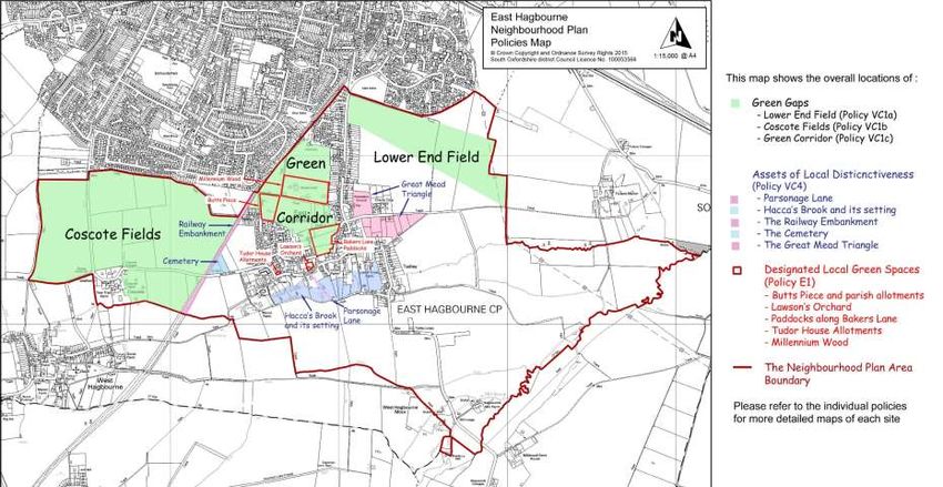
Appendix 5: Neighbourhood Plan Community Survey (NPCS), 2016 ......................... 76
    Appendix 6: East Hagbourne Conservation Area - a Character Study (SODC, 2000)
                76
    Appendix 7. East Hagbourne Parish Plan Consolidated Report 2011-2015.............. 76
    Appendix 8. Methodology and Conclusions for Site Allocation ...................................... 76
    Appendix 8a Site Assessment and Evaluation - Detailed Results................................... 76
    Appendix 9 Housing Needs Assessment .................................................................................. 76
    Appendix 10 East Hagbourne Green Buffer Assessment July 2018 .............................. 76

List of Figures

 Figure 1.           The boundary of East Hagbourne Parish, as revised in May 2015.
 Figure 2.           Didcot Garden Town Masterplan Boundary (shown by brown line) and
                     proposed green areas.
 Figure 3.           Policies Map, showing those policies affecting specific areas within the
                     Neighbourhood Plan area.
 Figure 4.           Local Gaps within East Hagbourne Parish.
 Figure 5.           Key Views.
 Figure 6.           Landcover parcels in East Hagbourne parish.
 Figure 7.           Areas identified as assets of local distinctiveness.
 Figure 8            Plan of East Hagbourne Conservation Area from the SODC Character
                     Assessment of 2000 (Appendix 7).
 Figure 9.           Site allocated for housing development.
 Figure 10.          Public Footpaths in East Hagbourne Parish.
 Figure 11.          Location of Designated Local Green Spaces.
 Figure 12           Location of Butts Piece - designated as Local Green Space.
 Figure 13           Location of Lawson's Orchard - designated as Local Green Space.
 Figure 14           Location of paddocks in Bakers Lane - designated as Local Green Space.
 Figure 15           Location of Tudor House Allotments - designated as Local Green Space.
 Figure 16           Location of Millennium Wood - designated as Local Green Space.
 Figure 17           Environment Agency Flood Map for East Hagbourne.
                                                                                                                                3
                                                                                                                                Page

                                         East Hagbourne NP Made Version 07/2020                            Page 3 of 76
1. Introduction
The Localism Act 2011 introduced Neighbourhood Planning into the hierarchy of spatial
planning in England giving communities the right to shape their future development at a
local level.

South Oxfordshire District Council approved East Hagbourne’s application to carry out a
Neighbourhood Plan in January 2016. The East Hagbourne Neighbourhood Plan (EHNP)
has been produced by a steering committee including parish councillors and community
volunteers, with expert support from South Oxfordshire District Council, Community First
Oxfordshire and AECOM. Financial support was provided by SODC and Locality.

The EHNP sets out a plan for the sustainable future for the village, taking into account the
views and needs of the residents. The Plan period extends for 16 years.

The EHNP sets out objectives and policies that will be used in shaping the future
development of the parish. These have been established through extensive public
consultation and are underpinned by both statistical information and local knowledge
and studies. The aims and objectives of the EHNP relate principally to planning matters
but also have relevance to other issues important to the community.

The Plan policies are compatible with South Oxfordshire District Council’s Development
Plan and meet the community’s aim of ensuring that East Hagbourne continues to thrive,
whilst retaining its unique and distinctive character and providing an outstanding quality
of life for current and future generations of residents.

The Plan was submitted for referendum on 14 March 2019 and the Plan was supported
by 93.5% of those voting on a 41.3% turnout. It was adopted by South Oxfordshire District
Council at a full Council meeting on 11 April 2019 and so becomes part of South
Oxfordshire District Council’s Development Plan. This means that the Neighbourhood
Plan has full weight in deciding where any development should take place and the type
and character of the development.

Chapter 2 outlines the history of the Plan preparation. Chapter 3 describes the parish of
East Hagbourne and sets the context within which this plan will operate. The East
Hagbourne Neighbourhood Plan vision, objectives and policies, together with justification
and summary evidence, are in Chapter 4 and Chapter 5 outlines Community Needs as a
basis for consideration of future planning applications

Further evidence in support of the Neighbourhood Plan is provided in the Appendices and
in the supporting evidence documents.

   •   Basic Conditions Statement
   •   Consultation Statement
   •   Strategic Environmental Assessment

   2. The East Hagbourne Neighbourhood Plan
                                                                                               4
                                                                                               Page

                               East Hagbourne NP Made Version 07/2020          Page 4 of 76
2.1 How the EH Neighbourhood Plan fits into the Planning
System
Although the Government’s intention is for local people to decide what goes on in their
towns, the Localism Act sets out some important laws. One of these is that all
Neighbourhood Plans must be in line with the National Planning Policy Framework
(NPPF) and local policy.

The EHNP must be in general conformity with the strategic policies contained in the
development plan for the area. Currently, the development plan in South Oxfordshire
consists of:

   •   South Oxfordshire Core Strategy (2012)
   •   Saved policies of the Local Plan 2011 (2006)

South Oxfordshire District Council is preparing a new Local Plan referred to in this
document as the Emerging Local Plan.

Neighbourhood Plans must be in line with European regulations on strategic
environmental assessment and habitat regulations.

2.2 Designation
The area covered by this Neighbourhood Plan is the whole area of East Hagbourne parish
as it exists following the boundary changes of May 2015. In accordance with regulations,
SODC publicised the Neighbourhood Plan application from East Hagbourne Parish Council
and advertised a 6-week consultation period ending 3rd December 2015. The Head of
Planning at South Oxfordshire District Council designated the area shown in Map 1 below
as the East Hagbourne Neighbourhood Area on 31st March 2016.

                                                                                           5
                                                                                           Page

                              East Hagbourne NP Made Version 07/2020       Page 5 of 76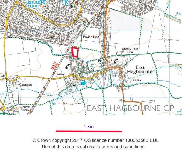
Figure 1. The boundary of East Hagbourne Parish, as revised in May 2015.
Marked up from © Crown copyright 2017 OS licence number 100053566 EUL. Use of this data is subject to terms and conditions.

2.3 Community engagement
An advisory group of the Parish Council – the East Hagbourne Neighbourhood Plan
Steering Group - took the EHNP work forward, supported by expert advice from SODC,
Community First Oxfordshire and AECOM.

The Steering Group followed a community consultation process, the aims of which were:

•        To involve as much of the community as possible throughout all consultation
         stages of Plan development so that the Plan was informed by the views of local
         people and other stakeholders from the start of the Neighbourhood Planning
         process
•        To ensure that consultation events took place at critical points in the process
         where decisions needed to be taken
•        To engage with as wide a range of people as possible, using a variety of approaches
         and communication and consultation techniques
•        To ensure that results of consultation were fed back to local people and available
         to read via the EHNP website as soon as possible after the consultation events.

The Steering Group encouraged community involvement through open meetings,
workshops, the website, use of an Email List, Leaflet drops, Posters, Letters to landowners,
statutory consultees and stakeholders, Local media and word of mouth.
                                                                                                                              6
                                                                                                                              Page

Progress of the EHNP was discussed at each Parish Council meeting.

                                           East Hagbourne NP Made Version 07/2020                            Page 6 of 76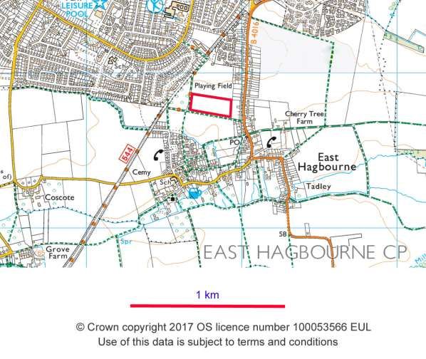
An initial scoping consultation and a comprehensive community consultation survey the
Neighbourhood Plan Community Survey, (NPCS) was distributed to all households, which
assessed housing need and other key issues for the village.

The Steering Group commissioned a comprehensive Village Character Assessment and
Landscape Study which was prepared by professional experts with extensive local input
from the community. This was made publicly available and presented at a workshop
designed to elicit feedback from the community.

In August 2017, a decision was made to carry out a Site Assessment and Evaluation with
a view to making an allocation for housing. A Community Group was established to create
wider community involvement more closely directed toward the topic of development
site allocation. A list of potential sites for allocation was identified and letters were sent
to landowners. The Community Group and Steering Group (20 people) took on the task of
evaluating the sites and preparing a recommendation of a single site for housing
development.

At each stage in the Plan process, elements such as the Plan objectives and draft policies
have been refined in response to feedback from residents and landowners.

The community consultation process is documented in the Consultation Statement.

2.4 Preparation of the Draft Plan
The Steering Group drafted policies to meet the EHNP objectives. In this task, the Steering
Group had input from Community First Oxfordshire, the District Council and an
independent planning advisor.

Community feedback on policies allowed further refinement. The justification, evidence
and local support underpinning each of the EHNP policies will be clearly set out in this
document.

The Village Character Assessment and Landscape Study made recommendations for
green spaces that should be protected. From this list, the Steering Group prepared a
shorter list of those meriting Local Green Space protection and letters were sent to land
owners inviting their comments.

In August 2017, it was decided that a full review of potential building land would be
performed to consider an allocation of land for housing development. Expert help was
provided by AECOM, with financial support from Locality. The principles of this
evaluation are outlined in section 3.4 and the conclusions in section 4.3.3. The
methodology is explained in more detail in Appendix 8.
                                                                                                 7
                                                                                                 Page

                                East Hagbourne NP Made Version 07/2020          Page 7 of 76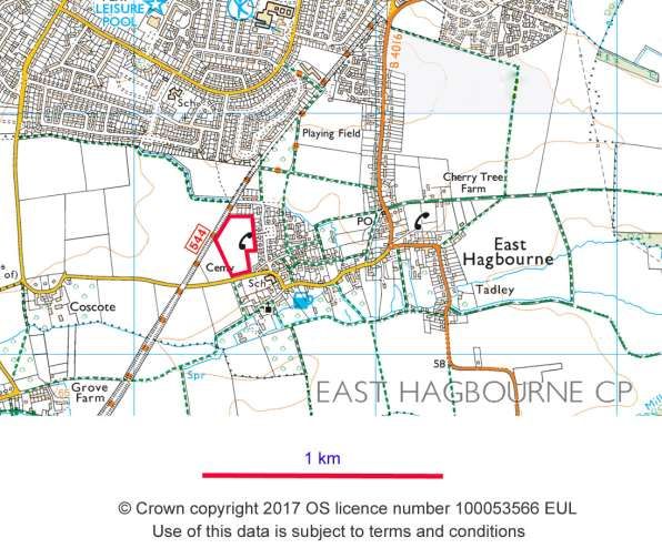
2.5 Submission, Examination and Adoption
This document is the Made version of the EHNP.

The pre-submission draft was published for a six-week consultation period running from
1st March 2018 to 14th April 2018. Comments received during this consultation, together
with representations from land owners in previous correspondence were analysed and
changes made to the report where appropriate. These changes have been reviewed by the
District Council. A record of those consulted, the comments received and the actions taken
is contained in the Consultation Statement. At the same time, a number of editorial
changes to the report were made to present the information more clearly and avoid
duplication.

The Plan was formally submitted to SODC on 17th September 2018. Following review and
approval, South Oxfordshire District Council publicised the Plan for six weeks, beginning
16th November 2018 and submitted it to an independent examiner together with other
Plan documents – the Basic Conditions Statement, Consultation Statement and Strategic
Environmental Assessment. The examiner has made recommendations to ensure that the
Plan meets the basic conditions and has recommended that with these changes it should
go forward to a referendum. The recommendations made by the examiner were
considered by the District Council in consultation with East Hagbourne Parish Council and
the Plan amended to incorporate the examiner’s comments.

The District Council then determined that the Plan should progress to a local referendum
where voters in the parish of East Hagbourne were asked whether they wanted South
Oxfordshire District Council to use the Plan to help it determine planning applications in
the area. The referendum took place on 14 March 2019 and the Plan was supported by
93.5% of those voting on a 41.3% turnout. It was adopted by South Oxfordshire District
Council at a full Council meeting on 11 April 2019 and has become a 'made' Plan. Together
with the Development Plan, the Neighbourhood Plan will be used for deciding planning
applications in East Hagbourne within the Plan period from when it was 'made' to 2033.
This Plan will apply to any and all development in the Neighbourhood Plan area.

                                                                                             8
                                                                                             Page

                              East Hagbourne NP Made Version 07/2020         Page 8 of 76
3. The Parish of East Hagbourne
3.1 A brief history
East Hagbourne has a long and distinguished heritage. There is evidence of occupation of
the area during the Iron Age and the village was one of the larger centres in this area in
Saxon times. East Hagbourne is listed in the Domesday Survey (1086) and this is recorded
in a plaque on the wall of the previous Post Office in Main Road. Throughout its history
East Hagbourne has been involved in agriculture, and the Domesday record listed 14
farms and two mills in the area.

In the 19th/20th century the village was known for orchards, water cress beds and hops.
There is one remaining hop kiln at Manor farm and hops can still be found growing in
hedgerows. East Hagbourne was known for paper making and it is said that blotting paper
was invented here. The railway line between Didcot and Newbury, built in the late 19th
century, came through East Hagbourne and is used today as a cycle and walking trail. Most
development up to the 19th century was in the area around Main Road and Fieldside with
some down Bakers Lane. In the middle of the 20th century there was significant ribbon
development along New Road and Blewbury Road and substantial areas of social housing
were established close to the historic village in the Harwood Road/Wilcher Close area.
The area around the centre of the village was designated as a Conservation Area in 1970
and its boundary extended in 1993.

The boundary of the Parish has been progressively modified as Didcot has grown, the last
change being in 2015 when an area of Millbrook amounting to 300 houses, formerly in
East Hagbourne, was transferred to Didcot Parish. The distinction between town and
village has thus been reinforced.

3.2 Location and context
East Hagbourne lies to the south of Didcot and is surrounded on three sides by open
farmland. The Parish itself extends to the small hamlet of Coscote to the west, and to
Hagbourne Mill on the road to Blewbury. To the north, the village continues along New
Road towards Didcot, and the newer area of Bishop's Orchard lies within the Parish
providing a diversity of accommodation and environment. East Hagbourne has a
population of 1158 (Census 2011, using the 2015 database reflecting the new boundary
post-2015).

Despite the proximity to Didcot, East Hagbourne has retained its strong rural character
largely because of its setting in open countryside where the village centre is surrounded
by open fields and farm land. The sight of farm vehicles frequently coming through the
village is a constant reminder of the agricultural activity which has created the character
of the surrounding areas. Several tracks and footpaths lead from Main Road and cross the
surrounding fields, bringing fields and the village closely together. The very extensive
network and mixed variety of footpaths add greatly to the village character.
                                                                                              9
                                                                                              Page

                               East Hagbourne NP Made Version 07/2020         Page 9 of 76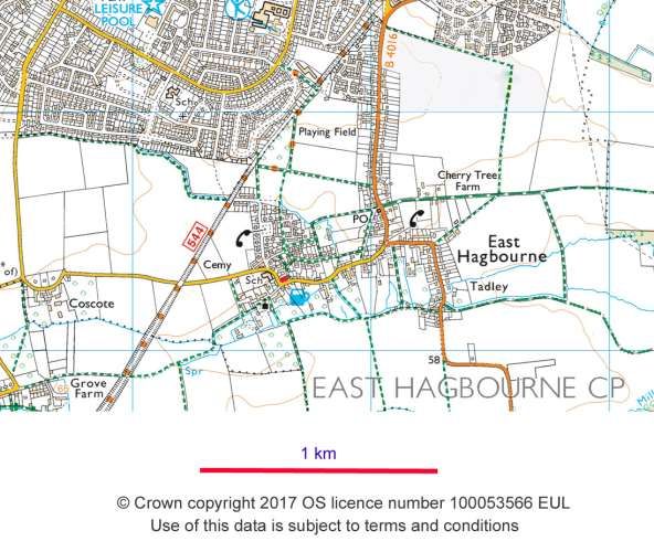
The views out of East Hagbourne to fields and hills around are a very important feature
and a strong element of the village character. The views from New Road and Blewbury
Road areas towards the Chiltern Hills AONB and the extensive open views south of the
village to the Wessex Downs AONB are particularly outstanding.

The Sustrans route along the former railway embankment offers immediate elevated
panoramic views towards the village and outwards towards the surrounding open
countryside. This is of particular significance in relation to the views to the church/manor
farm complex and across the Southern and Coscote fields. It is a key resource benefitting
the village, Didcot and other surrounding areas.

Another aspect of East Hagbourne that lends itself to enhancing the village character is
the very varied range of buildings most of high quality and many with interesting
historical connections from the Civil War and before. East Hagbourne survived a great fire
in 1659 and several buildings predate this fire including of course the church. There are
45 listed buildings and two scheduled monuments in the parish and the village pub, the
Fleur de Lys, is a listed pub.

Our local town of Didcot is less than 2 miles away and is convenient for services and
transport links to Oxford, Reading and further afield. An hourly bus service operates from
East Hagbourne, and also provides links to neighbouring villages. The growth of Didcot
has brought much improved facilities, but also constantly increasing traffic which is a
cause of concern to residents.

The numerous footpaths giving access both within the village and to the wider
countryside make this a good place to explore on foot, and the easy access from south
Didcot means that many people from the town are also able to enjoy the green
environment. The open fields give fine views to the downs and close to the village itself
there are paddocks, allotments and areas dedicated to nature.

The historic core of the village comprising Main Road, part of Blewbury Road and Tadley
has been designated as a Conservation Area. The SODC study East Hagbourne
Conservation Area – a character study 2000 (Appendix 6) notes that despite its proximity
to Didcot, East Hagbourne has retained a strong rural character with a distinct identity.
Although there has been some infill development on Main Road, the majority of buildings
are historic and this forms much of the village’s charm. Since many different building
materials have been employed in the village, a wide variety of textures and colours in the
buildings also add to the interest of the place. As shown in the East Hagbourne Village
Landscape & Character Assessment (Appendix 2) this variety in the built environment can
also be found in the wider village area as well as the outlying settlements at Coscote and
Hagbourne Mill. Significant landscape features identified include a number of examples of
medieval field pattern, ridge and furrow farming, a stock funnel, ancient farms and barns,
orchards, and medieval archaeology. Recent excavations in connection with development
in the area indicate that there is a potentially rich archaeological heritage still to be
discovered.
                                                                                               10
                                                                                               Page

                              East Hagbourne NP Made Version 07/2020         Page 10 of 76
3.3 Development context
This plan has been prepared to be in conformity with national policy and guidance and
with the NPPF/NPPG (March 2012) and the South Oxfordshire Development Plan. This
includes saved policies from 2011 (Saved Policies); Core Strategy 2012 (core strategy)
and the emerging South Oxfordshire Local Plan - Final publication Version, October 2017
(Emerging Local Plan).
The current SODC Local Plan 2011 has allocated land to the west and north of Didcot for
major building projects. The Emerging Local Plan reiterates these allocations and
presents a strategy to spread housing more evenly around the District.
Our Neighbourhood Plan supports planned development for East Hagbourne and the
surrounding areas as it is being developed through the context of the SODC Core Strategy
(2012) and SODC Emerging Local Plan together with the Didcot Garden Town Delivery
Plan which set the development context for the area including our village.
The objectives of the emerging Local Plan provide strong support for neighbourhood
planning and seeks to empower local communities to direct development in their areas
by supporting the “way of life” of rural communities. Overall, the objectives of the
emerging Local plan seek to deliver high quality development, respecting the scale and
character of villages such as East Hagbourne.
The core strategy sets out an overall strategy for the development of South Oxfordshire.
Didcot features prominently in the Core Strategy and emerging policies, and though East
Hagbourne is designated as a “Smaller Village”, its proximity adjacent to Didcot is a
significant factor in the policies in this plan.
Didcot has become a focus for major new development, providing an enhanced role in
providing homes, jobs and services. East Hagbourne’s parish boundary is adjacent to
Didcot and will therefore be affected by development there. This close proximity and
inter-relationship underpins the policies in this plan which seek to protect the special
character whilst allowing East Hagbourne to play its part in the wider strategic settlement
hierarchy of South Oxfordshire.
The SODC Emerging Local Plan sets as a vision that "South Oxfordshire will remain a
beautiful and prosperous place to live”. It will be an attractive place for people to work
and spend their leisure time. In support of this Objective 1.2 supports rural communities
and “their way of life’, recognising that this is what attracts people to the district. At the
same time, Objective 1.1 supports the settlement hierarchy and the growth and
development of Didcot Garden Town. The unique and different roles of town and village
in contributing to our District are thus recognised.
The Didcot Garden Town Delivery Plan (October 2017, p257) recognises the importance
of the landscape setting and proposes green buffers to the surrounding ‘necklace of
villages’ around Didcot, citing the recent dismissal of the planning appeal on land between
Didcot and East Hagbourne as reinforcing the role that open space plays in preventing the
11
coalescence of Didcot and its surrounding villages.
Page
East Hagbourne NP Made Version 07/2020 Page 11 of 76Part of the parish including New Road, Lower End Field and Coscote Field is included in
the proposed Didcot Garden Town boundary and the whole of our parish is included in
the "area of influence" for the Garden Town. Our village will therefore play a key part in
the successful implementation of the Garden Town policies including providing a key
buffer zone to the south of Didcot.
Our Neighbourhood Plan is aligned with these objectives and seeks to recognise and
enhance the role that our village plays in the wider district context. In particular,
Objectives VC1 and VC2 seek to preserve the independent and rural character of our
village, while responding to the housing needs of residents and the expectations of SODC’s
Local Plan.
3.4 Land for future housing-allocation
The Emerging Local Plan does not make specific housing allocations for smaller villages,
but identifies through Policy H8 that a minimum of 500 new homes will be delivered in
the 54 ‘smaller villages’ as a group. This will be achieved through Neighbourhood
Development Plans which allocate sites for at least a 5% increase in dwelling numbers
above those recorded in the 2011 census. In ‘smaller villages’ where there is no
Neighbourhood Development Plan a 5-10% increase in dwelling numbers, above those
recorded in the 2011 census, will be achieved through the development of suitable sites
and through infill development.
The supporting text adds that smaller villages, as defined in the settlement hierarchy are
likely to deliver 5%-10% growth, based on the number of dwellings at the 2011 census,
minus completions since 2011 and outstanding commitments. The provision of 500
homes should be viewed as a minimum level of growth and will be met through small sites
and infill development and will not be allocated by the local planning authority. The
relationship between the smaller villages and the larger villages and the district’s towns
will be important in the pattern and level of development to be delivered. Smaller villages
will look to the larger villages and towns for a higher level of services and facilities and it
is this relationship which will help to shape future development.
The Parish Council is supportive of this target which would allow the community to grow
and develop in a natural way, without harming the character of the community. For our
village of 500 dwellings, 10% growth would represent 50 houses over the plan period.
Since the baseline starting date of May 2011, 5 infill dwellings have already been delivered
or currently being built within the Parish and a further 6 have planning permission. The
provision of such growth is in line with the expression of housing need identified in the
Parish Survey (NPCS), Appendix 5, where residents expressed a desire for small infill
developments and were not in favour of larger developments. However, outline planning
permission has now been granted (at the end of January 2018) for 74 dwellings on land
adjoining Hagbourne Village Hall on Main Road and identified as Site 5 in our site
assessment process and the Reserved Matters is currently being considered by South
Oxfordshire District Council.
12
This Plan implements the objectives of the Emerging Local Plan by:
Page
East Hagbourne NP Made Version 07/2020 Page 12 of 76• Identifying and protecting what is special about our settlement, but also supporting
an appropriate scale of development,
• Allocating land for housing which together with already approved development will
provide growth well over the minimum expectations of the Emerging Local Plan.
The location of East Hagbourne Parish immediately to the south of Didcot makes it
particularly vulnerable to applications on unallocated sites seeking to provide housing for
the wider district. In addition to the scheme for up to 74 houses on land adjacent to
Hagbourne Village Hall an application for 78 houses was submitted and subsequently
refused for a site at the eastern end of the village. Together these developments would
have increased the number of dwellings in the village community by 30%, far exceeding
the expectations of the Local Plan. Four further major unplanned applications were also
put forward and refused which would have totalled several hundred houses within the
Parish boundary. The location and scale of these proposed developments do not respect
the important local distinctiveness of the village and its character and setting. Several are
distant from the village community itself and if approved would form part of Didcot rather
than East Hagbourne, but would impair the open and rural nature of the parish that is
appreciated by village and town alike.
A planning application by Grainger which was dismissed at Appeal and judicial review
stage in 2017 would have closed an important Green Gap between Didcot and East
Hagbourne. The application was dismissed on the grounds that
− the gap afforded by the site is particularly important in providing a clear sense of
separation between Didcot and East Hagbourne
− The site forms part of a network of fields on the edge of East Hagbourne, and as such
contributes to the rural setting and character of the village.
− Its rural appearance also provides a green and open setting for Didcot.
− The development would adversely affect the setting of the AONB.
These considerations may also be relevant to other sites for which development proposals
are being considered. We believe that a positive Neighbourhood Plan can help achieve a
balanced approach that meets housing needs while preserving important local features.
East Hagbourne village itself has particular constraints that make finding obvious
candidate sites for allocation challenging. The built-up areas of the Parish have been
infilled gradually over the last few decades leaving few obvious opportunities to add more
units. Existing in-fill is coming mainly from sub-division of existing plots, which risks the
loss of gardens and the more rural atmosphere of the village. Expanding the village
outwards is also constrained: going North by the need to preserve the gap between East
Hagbourne and Didcot which is important to the independent existence of the village.
Land to the South and East the village closely abuts or provides key views to and from the
Chiltern and North Wessex AONBs. To the West expansion is limited by the embankment
of the former Didcot to Newbury railway line. The extensive network of footpaths
provides access to the countryside for all of the area's residents and is recognised in the
Didcot Garden Town Plan where most of the land around the village is proposed as a
Green Buffer for Didcot.
The future housing numbers needed within East Hagbourne under the Local Plan and as
13
identified in the NPCS could be met by natural growth. In preparing this Neighbourhood
Page
Plan, however, it became clear that because of the pressure for housing development in
East Hagbourne NP Made Version 07/2020 Page 13 of 76South Oxfordshire and in view of the shortfall at that time in relation to a 5 year housing
land supply, the needs of the community would be better served by a more proactive
approach. An evaluation of potential building sites across the Parish was therefore
undertaken, with a view to making an allocation for housing. To identify the particular
unit size and type of housing needed to best support development of our community we
commissioned a Housing Needs Assessment (Appendix 9).
In approaching the question of site assessment for potential allocation, we took the view
that all land in the NP area should be included in an initial pre-screening exercise. The
land within East Hagbourne Parish was divided into 10 landscape areas and then further
subdivided to give a total of 53 land parcels for evaluation. This comprehensive coverage
means that all SODC's SHELAA sites are included as are those offered under a call for sites
carried out as part of the NP process.
The Locality Toolkit sets out a number of national criteria for site assessment and these
have all been incorporated into our assessment. However, the NPPF also makes provision
for local criteria to be used, provided that these are objective. In discussion with SODC 1,
we adopted the following local criteria:
− Is the site closely related to, and well integrated with the village?
− Is the site easily accessible to EH services and facilities by both roads & footpaths?
− Does the site flood or could it create flooding /environmental issues?
− Will development impact the Conservation Area or the setting of the AONB?
As a result of the pre-screening exercise, six sites were identified for more detailed
assessment as potential allocation sites. These were subjected to a more detailed site
assessment, consultation with land owners and finally an evaluation which showed that
two of the six sites were potentially suitable for allocation.
These are:
− Site 2. East Tadley Field A (Orchestra) [planning application has since been refused].
− Site 5. Western Village Plotlands (Greenlight) [outline planning permission has
recently been granted].
The Site Evaluation was submitted to AECOM who had earlier produced an SEA Scoping
report and have now carried out a full SEA evaluation. AECOM compared two allocation
strategy options, i.e. Site 5 only; and Site 5 plus Site 2 and highlighted pros and cons
associated with each option. The broad conclusion was that allocation of both sites would
lead to a range of concerns over-and-above allocation of Site 5 only, most notably in
respect of landscape and loss of best and most versatile agricultural land. While not
specifically covered in the SEA, they also noted that the access and traffic issues, while
presenting challenges for both sites, could be more easily managed for Site 5.
A comparison of these sites and our proposals for allocation are outlined in Section 4.3.3.
The methodology is explained more fully in the supporting documents.
14
Page
1 Meeting of 23rd August 2017
East Hagbourne NP Made Version 07/2020 Page 14 of 763.5 Village Character
It is clear from village meetings and the NPCS that residents of East Hagbourne have a
very strong feeling of local identity and value the fact that East Hagbourne is an ancient
and well defined small village in South Oxfordshire. A very important aspect of the village
is its rural nature and setting and the very good access to the open countryside through a
well-maintained network of footpaths both within the village envelope and connecting
the village to open farmland and neighbouring villages. The open spaces that surround
the built environment are particularly valued.
A detailed East Hagbourne Village Landscape & Character Assessment (Appendix 2) was
commissioned as part of the preparation of this plan. The Character Assessment provides
a detailed assessment of the built environment and its setting, covering the whole of the
parish as it has developed to the present day, in accordance with the aims of The National
Planning Policy Framework (NPPF):
• To place good design, local character and conservation of the historic and natural
environment at the heart of sustainable development and good planning.
• To conserve heritage assets and their settings in a manner appropriate to their
significance and putting them to viable uses consistent with their conservation.
• For any development to make a positive contribution to local character and
distinctiveness, drawing on ‘the contribution made by the historic environment to the
character of place' (paragraph 126, 29).
The NPPF defines the historic environment as resulting from ‘the interaction between
people and places through time’. This simple definition places people and their
perceptions at the centre of understanding what makes places distinctive and what
benefits they offer, how they have changed into their present form and how they can
change in the future.
3.6 Our Challenges
We have given full consideration to the strengths, weaknesses, opportunities and threats
faced by East Hagbourne in the SWOT analysis forming part of the evidence base in
Appendix 4 of this plan, but highlight here a few of the main challenges faced by our village
as set out below.
Community Facilities
For its size, the village is well provided for in terms of community facilities. It has a well-
established successful primary school, pre-school, a village hall, public car park, church,
small community run shop with post office, a single pub and a sports field with children’s
play area and a new Pavilion building. Except for the school which is OCC funded, these
facilities are however, considered to be economically vulnerable and/or dependent upon
community volunteers. In our Neighbourhood Plan Community Survey carried out in the
summer of 2016, residents expressed a desire for additional facilities and activities for
teenagers, village based medical facilities and a daytime social facility such as a café.
The village may need land for future expansion of community facilities such as Hagbourne
15
Village Hall, the village car park or possibly Hagbourne School. The village archive is
Page
currently housed in the village hall, but specific premises may be needed in the future. The
East Hagbourne NP Made Version 07/2020 Page 15 of 76highly compact and constrained nature of our village settlement means that suitable sites
for such development are difficult to identify.
High Speed Broadband is available in the village, but is currently unable to reach the area
most remote from the fibre optic box. Initiatives by residents of Manor Farm Lane,
together with BT, have recently been successful in improving broadband speeds in that
area of the village.
Traffic, Transport and Parking
As Didcot expands, the road network particularly Main Road and the B4016 (Blewbury
Road/New Road) are experiencing increasing levels of through traffic and the speed and
weight of some of the vehicles is considered to be particularly problematic on what are
typically narrow rural roads. Traffic issues were extensively studied in the East
Hagbourne Parish Plan (Appendix 7), but were not fully resolved. East Hagbourne
benefits from its proximity to Didcot Parkway Station however its access to bus services
is limited. Within the village, parking particularly close to village assets such as the
school/pub/shop is limited and on street parking can cause local congestion. There is an
identified need for more parking in the area of the village hall and School. The approved
development adjacent to Hagbourne village Hall proposes some increase in spaces in the
village Car Park. Cyclists benefit from the Sustrans route linking the village to Didcot and
Upton, but more could be done to encourage increased cycling.
Coalescence with Didcot
The close proximity of Didcot combined with its rapid planned expansion as a Garden
Town and centre of the Science Vale potentially threatens the independent existence of
the village as buffer land between the two settlements comes under threat of
development.
Environmental Issues
The traditionally managed farmland some of which has clear evidence of ancient “ridge
and furrow” farming provides the setting to the historic village. Loss of farmland is of
particular concern to villagers as expressed in the NPCS.
As climate change progresses it is expected that flood risks on land adjacent to Hacca's
Brook, from field run-off, and from inadequate storm water capacity are likely to increase.
Housing Needs
The NPCS identified a strongly held perception that the village has a surplus of 4 bed plus
houses and a relative lack of small (2/3 bed) homes, bungalows and specialist elderly
accommodation to fit the needs of an ageing population and to provide greater
opportunities for first time buyers. A Housing Needs Assessment (Appendix 9) was
commissioned to provide a more comprehensive understanding based on regional and
national data as well as the input from the NPCS.
Preserving Village Character
Increased traffic as a result of Didcot's expansion places greater pressure on local roads.
In particular, there have been several examples of damage to grass verges caused by large
vehicles. Where new developments are proposed, street works and traffic calming risk
damaging the special character of the area. Outside the built areas, the East Hagbourne
16
Village Landscape & Character Assessment (Appendix 2) identified a number of historical
features including ridge and furrow cultivation that could be under risk from
Page
development.
East Hagbourne NP Made Version 07/2020 Page 16 of 764. The Neighbourhood Plan – Vision, Objectives and
Policies
The Neighbourhood Plan has been underpinned and guided by extensive community
consultation and engagement as detailed in the Consultation Statement. The Steering
Group identified draft objectives and policies from these consultations and then
presented them to residents, allowing for ongoing refinement and ensuring that that plan
best reflects community aspirations.
4.1 The vision for East Hagbourne
To safeguard the individual character, vitality and community facilities of our historic
village and protect its rural environment for the health and wellbeing of town and
village residents alike, whilst supporting sustainable development that meets the needs
of residents now and in the future.
4.2 Objectives
SUSTAINABLE DEVELOPMENT
SD1 Support sustainable development that meets the needs of residents now
and in the future.
VILLAGE CHARACTER
VC1 Preserve the independent and rural character of our village as Didcot
expands. Conserve and enhance key views both into and out from the
built areas and within the built areas
VC2 Conserve and enhance the heritage of the historic core of the village
within and adjoining the Conservation Area together with its Listed
Buildings and structures.
VC3 Protect the village envelope and surroundings from light pollution
HOUSING
H1 Respond to housing needs of residents and provide a proportionate
contribution to meet SODC’s housing requirements
COMMUNITY
CF1 Ensure that village infrastructure and facilities support village life now
and into the future.
TRANSPORT AND ACCESS
TA1 Maintain and improve road safety for all road users.
TA2 Promote mobility and maintain or enhance the quality of pavements
without creating an urban appearance.
TA3 Ensure that new development does not add to the problem of on-street
parking.
GREEN SPACE, ENVIRONMENT AND CONSERVATION
E1 Maintain and enhance green spaces for the health and wellbeing of the
community
E2 Maintain and enhance biodiversity
E3 Protect housing from flooding
17
Page
East Hagbourne NP Made Version 07/2020 Page 17 of 764.3 Policies
Policies have been grouped under the same general themes as our objectives:
• Sustainable Development
• Village character
• Housing
• Community
• Transport and access
• Green space, environment and conservation
In this section, each of these themes is given a general introduction. Policies which
support each objective are then presented. Policies are set out with supporting evidence.
4.3.1 Sustainable Development
OBJECTIVE POLICY
SD1 - Support sustainable development that SD1 – Sustainable Development
meets the needs of residents now and in the
future.
Sustainable Development remains the overarching theme of national policy and the Core
Strategy and it is essential to consider the effects that development will have on the wider
economic, social and environmental dimensions (NPPF para. 7, Core Strategy CS1)
As explained in the foreword to the NPPF, sustainable means ensuring that better lives for
ourselves don’t mean worse lives for future generations. Sustainable development is
about change for the better.
18
Page
East Hagbourne NP Made Version 07/2020 Page 18 of 76Policy SD1 – Sustainable development
In determining the acceptability of planning applications, the following points should
be used to guide the delivery of sustainable development.
Where appropriate, development proposals should show how they:
• Contribute to the vitality and viability of East Hagbourne parish; and
• Complement the local vernacular and character of the village and its rural
setting by use of an appropriate design; and
• Maintain, restore or enhance the local landscape character, paying special
attention to long-distance views including towards the AONB and views into and
out of the village of East Hagbourne or within the built area; and
• Do not increase the risk of flooding from either increased runoff or from
building within flood risk areas and take account of the predicted impact of
climate change during the lifetime of the development
• Conserve and enhance the historic environment and
• Conserve and enhance the landscape to achieve a net biodiversity gain and
habitat connectivity, paying special attention to the green and blue
infrastructure networks, landscape and biodiversity designations, priority
habitats and protected species; and
• Make development easily accessible by sustainable modes of transport to all
local and Didcot’s facilities; and
• Provide the necessary infrastructure and ducting to enable communications
services including high speed broadband to be delivered to new homes; and
• Minimize energy use and its overall carbon impact during construction and in
occupation and use.
The principle of Sustainable Development is central to the economic, environmental and
social success of the country as a whole and because of this is a core principle that
underpins all planning documents.
This Plan supports and encourages small scale development within the Parish focused
around the village of East Hagbourne. All development must however contribute to wider
sustainability objectives and the definition of sustainable development as set out in the
development plan.
The position of East Hagbourne immediately adjacent to the large and growing town of
Didcot with its significant and expanding facilities is a major factor in determining
sustainability of any development within the parish.
The village acts as green lungs within the Didcot Area and provides a distinctively
different environment which benefits both town and village. This is recognised in the
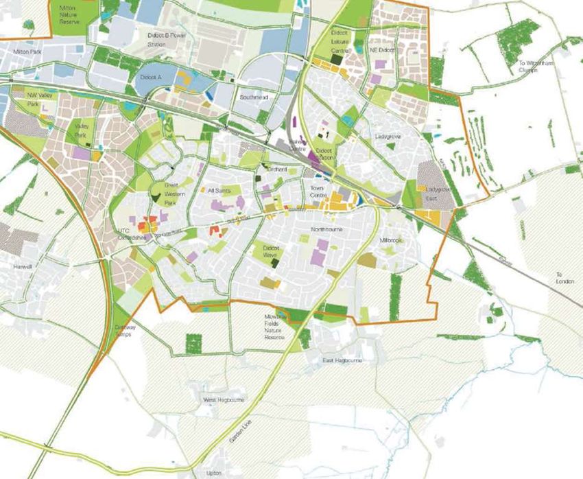
emerging Garden Town designation for Didcot. Didcot Garden Town Principle 2 highlights
Didcot’s unique identity, distinctive from surrounding towns and villages that respects
their rural character and setting and designates East Hagbourne Parish as one of its green
buffer zones. (Figure 2).
19
Page
East Hagbourne NP Made Version 07/2020 Page 19 of 76Figure 2. Didcot Garden Town Masterplan Boundary (shown by brown line) and
proposed green areas2
It is this principle for the future of Didcot that this plan will seek to deliver: Didcot and
East Hagbourne will benefit by maintaining their own unique identities so that each will
complement the other.
Development of all kinds (including change of use, extensions as well as new build) has a
range of wider consequences on other factors such as traffic generation, flood risk,
biodiversity, the Conservation Area, economic vitality and the landscape setting of the
Parish. All proposed development in the Parish must carefully consider the impact on
each of these factors.
The Neighbourhood Plan Community Survey (NPCS) conducted in in the summer of 2016
(see Appendix 5) examined residents’ attitudes to the overall issue of sustainability with
a variety of questions on multiple topics. It is clear that East Hagbourne residents are
20
highly engaged with sustainability issues and regard them as key to determining the
location, scale quality and type of any new development proposed in the Parish.
Page
2Didcot Garden Town Delivery Plan (October 2017) http://www.southoxon.gov.uk/business/support-
business/supporting-our-town-centres/didcot/didcot-garden-town-0
East Hagbourne NP Made Version 07/2020 Page 20 of 76Figure 3. Policies Map, showing those policies affecting specific areas within the Neighbourhood Plan area
Marked up from © Crown copyright 2017 OS licence number 100053566 EUL. Use of this data is subject to terms and conditions.
21
Page
East Hagbourne NP Made Version 07/2020 Page 21 of 764.3.2 Design and Character
OBJECTIVE POLICY
VC1 - Preserve the independent and rural character of Policies VC1a-c – Preserving the Local
our village as Didcot expands. Conserve and enhance key Gaps which define the distinctive
views both into and out from the built areas and within identities of East Hagbourne, Coscote
the built areas and Didcot
Policy VC2 - Conserving and enhancing
key views
Policy VC3 - Retaining small village
character and promoting good design
Policy VC4 - Assets of local
distinctiveness
VC2 - Conserve and enhance the heritage of the historic Policy VC5- Conserving and Enhancing
core of the village within and adjoining the Conservation Heritage Assets
Area together with its Listed Buildings and structures
VC3 - Protect the village envelope and surroundings from Policy VC6 - Lighting
light pollution
A Policies Map showing the location of those policies that relate to specific areas within
the Neighbourhood Plan area is shown in Figure 3. This map is intended to provide an
overview of how the different policies fit together. More detailed maps showing the
location of each site are included next to each relevant policy.
Preserving the Local Gaps which define the distinctive identities of East
Hagbourne, Coscote and Didcot
A very strong feeling of local identity and the value of East Hagbourne as a well-defined
small village in South Oxfordshire was articulated in the Neighbourhood Plan Community
Survey (Appendix 5) and in the community consultation meetings/workshops. A vital
component to maintaining this is to protect its physical separation, its rural and historical
nature and its setting. This is enhanced by the ready access to the open countryside
through a well-maintained network of footpaths both within the village envelope and
connecting the village to its open farmland and to neighbouring villages.
The NPPF does not refer specifically to local gap policies, but a principle of national policy,
outlined in NPPF Para 17, is to "take account of the different roles and character of
different areas . . . recognising the intrinsic character and beauty of the countryside and
supporting thriving rural communities within it."
22
The concept of local gaps is in general conformity with the strategic policies of the SODC
Local Plan. Saved policy C4 acknowledges the importance of the visual appearance of a
Page
settlement and discourages development which would damage the landscape setting of
East Hagbourne NP Made Version 07/2020 Page 22 of 76settlements. Policy C9 prevents the loss of landscape features and policy D1 sets out
principles of good design that include provision of a clear structure of spaces, respect for
existing settlement patterns and legibility through use of landmarks, vistas and focal
points, providing landscape structure as a framework for new development and
respecting the character of the existing landscape.
Core strategy policy CSEN1 seeks to protect the district’s distinct landscape character and
key features against inappropriate development and enhance them where possible, and
the Emerging Local Plan policy ENV1 supports this objective in similar wording. SODC's
Core Strategy (2012) states that a key aim is to maintain the relationship between the
various communities so that change is appropriate in scale, and we keep the character
and distinctiveness of our communities (para. 13.3). It further states, (para. 13.6) that the
overall strategy aims to support rural communities and to allow flexibility for
development that can assist sustainability but which does not detract from the character
of the settlement. Core Strategy Policy CSR1 says that "Local character and distinctiveness
will be protected and the requirements of relevant development plan policies will be met."
There is therefore strong support in the Development Plan for the principle of protecting
the distinct landscape character of a settlement. A planning refusal upheld at appeal in
March 2017 on Lower End Field referred to the undesirability of coalescence between the
settlements and the vital role played by this land parcel in maintaining the separation of
East Hagbourne and Didcot. Additional policy safeguards are required to protect this
critical and vulnerable landscape feature. Our policy provides specificity to complement
the more general provisions of the Development Plan.
The spatial distribution of growth in and around Didcot will ultimately be determined
through the emerging Local Plan and the (as yet unspecified) further detailed planning
policies for the Garden Town area. Plainly these various documents will provide
assurance on the delivery of housing growth in Didcot and the separation between Didcot,
the surrounding villages and their rural hinterlands. They also will provide the context
for the eventual delivery and identification of the green gaps envisaged in the Didcot
Garden Town Delivery Plan (October 2017). The proposed local gaps identified in this
Plan are an interim approach to this matter. Their extent and policy wording will be
reviewed once the emerging Local Plan has been adopted.
These Local Gaps are intended to prevent coalescence between Didcot and neighbouring
villages, protecting the identity, character and diversity of the area. To better define the
areas that should be included in the Local Gaps around East Hagbourne, an independent
study was commissioned to provide detailed evidence on the landscape value and
sensitivity of the land surrounding East Hagbourne. The consultant, Novell Tullett, is
engaged in similar studies for adjoining parishes. As well as providing evidence for this
Plan, these studies will provide information to inform the wider Didcot Garden Town Plan.
The East Hagbourne Green Buffer Assessment (Appendix 10) gives a more precise
evaluation of the boundaries of the Buffer Zones surrounding East Hagbourne, based on
objective, nationally recognised methodology.
23
Page
East Hagbourne NP Made Version 07/2020 Page 23 of 76You can also read