Evaluation of historic and operational satellite radar altimetry missions for constructing consistent long-term lake water level records

Page created by Edwin Myers
 
CONTINUE READING
Evaluation of historic and operational satellite radar altimetry missions for constructing consistent long-term lake water level records
Hydrol. Earth Syst. Sci., 25, 1643–1670, 2021
https://doi.org/10.5194/hess-25-1643-2021
© Author(s) 2021. This work is distributed under
the Creative Commons Attribution 4.0 License.

Evaluation of historic and operational satellite radar
altimetry missions for constructing consistent
long-term lake water level records
Song Shu1 , Hongxing Liu2 , Richard A. Beck3 , Frédéric Frappart4 , Johanna Korhonen5 , Minxuan Lan3 , Min Xu6 ,
Bo Yang7 , and Yan Huang8
1 Department  of Geography and Planning, Appalachian State University, Boone, NC 28608, USA
2 Department  of Geography, the University of Alabama, Tuscaloosa, AL 35487, USA
3 Department of Geography and Geographic Information Science, University of Cincinnati, Cincinnati, OH 45221, USA
4 Laboratoire d’Etudes en Géophysique et Océanographie Spatiales (LEGOS), UMR 5566,

CNRS/IRD/UPS, Observatoire Midi-Pyrénées (OMP), 14 Avenue Édouard Belin, 31400 Toulouse, France
5 Finnish Environment Institute, SYKE, Freshwater Center, Latokartanonkaari 11, 00790 Helsinki, Finland
6 College of Marine Science, University of South Florida, St. Petersburg, FL 33701, USA
7 Department of Sociology, University of Central Florida, Orlando, FL 32816, USA
8 Key Laboratory of Geographical Information Science, Ministry of Education, School of Geographical Science,

East China Normal University, Shanghai 200241, China

Correspondence: Song Shu (shus@appstate.edu) and Hongxing Liu (hongxing.liu@ua.edu)

Received: 1 October 2020 – Discussion started: 27 October 2020
Revised: 25 February 2021 – Accepted: 25 February 2021 – Published: 1 April 2021

Abstract. A total of 13 satellite missions have been launched    small lakes, ERS-1 and ERS-2 missions provided more ac-
since 1985, with different types of radar altimeters on board.   curate lake water level estimates than the TOPEX/Poseidon
This study intends to make a comprehensive evaluation of         mission. In contrast, for large lakes, TOPEX/Poseidon is a
historic and currently operational satellite radar altimetry     better option due to its lower data missing rate and shorter re-
missions for lake water level retrieval over the same set        peat cycle. GeoSat and GeoSat Follow-On (GFO) both have
of lakes and to develop a strategy for constructing consis-      an extremely high data missing rate of lake water level esti-
tent long-term water level records for inland lakes at global    mates. Although several contemporary radar altimetry mis-
scale. The lake water level estimates produced by different      sions provide more accurate lake level estimates than GFO,
retracking algorithms (retrackers) of the satellite missions     GeoSat was the sole radar altimetry mission, between 1985
were compared with the gauge measurements over 12 lakes          and 1990, that provided the lake water level estimates. With
in four countries. The performance of each retracker was as-     a full consideration of the performance and the operational
sessed in terms of the data missing rate, the correlation co-    duration, the best strategy for constructing long-term lake
efficient r, the bias, and the root mean square error (RMSE)     water level records should be a two-step bias correction and
between the altimetry-derived lake water level estimates and     normalization procedure. In the first step, use Jason-2 as
the concurrent gauge measurements. The results show that         the initial reference to estimate the systematic biases with
the model-free retrackers (e.g., OCOG/Ice-1/Ice) outperform      TOPEX/Poseidon, Jason-1, and Jason-3 and then normalize
the model-based retrackers for most of the missions, partic-     them to form a consistent TOPEX/Poseidon–Jason series.
ularly over small lakes. Among the satellite altimetry mis-      Then, use the TOPEX/Poseidon–Jason series as the reference
sions, Sentinel-3 gave the best results, followed by SARAL.      to estimate and remove systematic biases with other radar al-
ENVISAT has slightly better lake water level estimates than      timetry missions to construct consistent long-term lake water
Jason-1 and Jason-2, but its data missing rate is higher. For    level series for ungauged lakes.

Published by Copernicus Publications on behalf of the European Geosciences Union.
Evaluation of historic and operational satellite radar altimetry missions for constructing consistent long-term lake water level records
1644                                 S. Shu et al.: Evaluation of historic and operational satellite radar altimetry missions

1   Introduction                                                   Atmospheric Administration), NASA (National Aeronautics
                                                                   and Space Administration), CNES and EUMETSAT (Eu-
About 3 % percent of the Earth’s land surface is covered by        ropean Organization for the Exploitation of Meteorologi-
lakes (Pekel et al., 2016). These lakes are the habitats for       cal Satellites), and the HY-2A (2011–present) developed
a great number of aquatic and terrestrial species (Schindler       by CNSA (China National Space Administration). Most of
and Scheuerell, 2002). They are also the major freshwater          the radar altimeters operate in a conventional low-resolution
sources for various human activities (Postel et al., 1996). The    mode (LRM), whereas Sentinel-3 and CryoSat-2 operate in
long-term variations in lake water levels were identified as       synthetic aperture radar (SAR) mode. CryoSat-2 is also able
sentinel for climate change (Adrian et al., 2009; Williamson       to operate in the interferometric SAR (SARin) mode.
et al., 2009). The lake water level change can also have sig-         Based on the elevation measurements collected by differ-
nificant influences on the local ecosystem and environment,        ent satellite radar altimeters, five online databases have also
for example, the breeding success of fish (Probst et al., 2009),   been developed to offer the time series of altimetry-derived
the drainage of thaw lakes (Pohl et al., 2009; Marsh et al.,       water level estimates for major inland lakes around the world.
2009; Jones and Arp, 2015), and landslide at lake coastal ar-      These include the Hydroweb database (http://www.legos.
eas (Tyszkowski et al., 2015). Monitoring lake water levels        obs-mip.fr/soa/hydrologie/hydroweb/, last access: 15 Febru-
is important for a better understanding of their impact on the     ary 2021) developed by the Laboratoire d’Etudes en Géo-
environment and for the wise management of freshwater re-          physique et Océanographie Spatiales (LEGOS; Crétaux
sources.                                                           et al., 2011), the River and Lake database (http://www.
   At present, only a very small portion of lakes are mon-         cse.dmu.ac.uk/EAPRS/products_riverlake.html, last access:
itored by gauge stations. The number of gauged lakes has           15 February 2021) built by the ESA and De Montfort
decreased in recent years owing to the high cost of installa-      University (ESA-DMU; Berry et al., 2005), the Global
tion and maintenance of gauge stations (Hannah et al., 2011).      Reservoir and Lake Monitor (GRLM; https://ipad.fas.usda.
The overwhelming majority of the lakes on Earth remain un-         gov/cropexplorer/global_reservoir/, last access: 15 Febru-
gauged, particularly those located in remote areas with harsh      ary 2021) developed by the Foreign Agricultural Service
environments, for example, the Arctic and the sub-Arctic re-       of the United States Department of Agriculture (USDA)
gions. Many previous studies show that the lakes in these          (Birkett et al., 2011), the Hydrosat developed by the In-
remote areas have been experiencing dramatic changes with          stitute of Geodesy from the University of Stuttgart (http://
regard to the lake water balance (Turner et al., 2014), the tim-   hydrosat.gis.uni-stuttgart.de, last access: 15 February 2021),
ing and magnitude of spring/early summer flooding (Rokaya          and the Database for Hydrological Time Series over In-
et al., 2018), and the lake ice cover phenology (Surdu et al.,     land Waters (DAHITI; https://dahiti.dgfi.tum.de/en/, last
2014) due to rapid climate warming (Karl et al., 2015). There      access: 15 February 2021) launched by the Deutsches
is an urgent need to develop an alternative approach for the       Geodätisches Forschungsinstitut der Technischen Universität
effective monitoring of lake water levels at the global scale.     München (DGFI-TUM) in 2013 (Schwatke et al., 2015b).
   Satellite radar altimeters make surface elevation measure-      The time series of water level estimates in these databases
ments by tracking the satellite orbit position and the range       are produced by merging the elevation measurements from
between the satellite and the Earth’s surface at nadir direc-      multiple satellite radar altimeters with different processing
tion. They have been used widely to monitor lake water lev-        strategies (Birkett and Beckley, 2010; Ričko et al., 2012;
els since the 1980s. A total of 13 satellite missions have         Schwatke et al., 2015b).
been launched with different radar altimeters on board in             For each satellite radar altimeter, one or more dedicated
the past 3 decades. Those include the Geodetic/Geophysical         algorithms have been designed to retrieve the surface eleva-
Satellite (GeoSat; 1985–1989; McConathy and Kilgus, 1987)          tions. Each algorithm is often designed to handle one type
and GeoSat Follow-on (GFO; 1998–2008; Barry et al., 1995)          of Earth surface. These radar altimetry algorithms are also
developed by US Navy, ERS-1 (1991–2000; Cheney et al.,             known as retracking algorithms or simply retrackers. For ex-
1991), ERS-2 (1995–2011; Zandbergen et al., 1997), EN-             ample, there are four different retrackers designed for EN-
VISAT (2002–2012; Zelli, 1999), CryoSat-2 (2010–present;           VISAT altimeter, including the Ocean retracker for ocean
Wingham et al., 2006) and Sentinel-3 (2016–present; Don-           open water surface, the Ice1 retracker for general continental
lon et al., 2012) developed by ESA (European Space                 ice sheet surface, the Ice2 retracker for continental internal
Agency), the Satellite with ARgos and ALtika (SARAL;               flat ice surface, and the sea ice retracker for ocean ice surface
2013–present; Verron et al., 2015) developed jointly by            (Frappart et al., 2006).
CNES (Centre National d’Etudes Spatiales – the French                 Many previous studies have evaluated different satellite
Space Agency) and ISRO (Indian Space Research Organi-              radar altimeters in the retrieval of water levels over inland
sation), the TOPEX/Poseidon (T/P; 1992–2005; Lee-Lueng,            lakes with different sizes and environmental surroundings.
1994), Jason-1 (2001–2013; Menard et al., 2003), Jason-            Morris (1994) examined the performance of GeoSat over
2 (2008–present; Lambin et al., 2010) and Jason-3 (2016–           the Great Lakes (Erie, Huron, Michigan, Ontario and Supe-
present) developed jointly by NOAA (National Oceanic and           rior), and the root mean square error (RMSE) between the

Hydrol. Earth Syst. Sci., 25, 1643–1670, 2021                                       https://doi.org/10.5194/hess-25-1643-2021
Evaluation of historic and operational satellite radar altimetry missions for constructing consistent long-term lake water level records
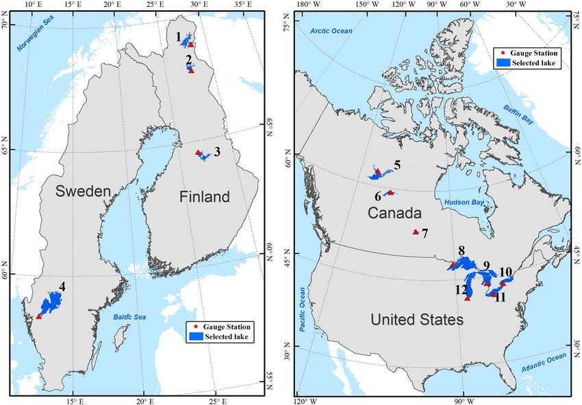
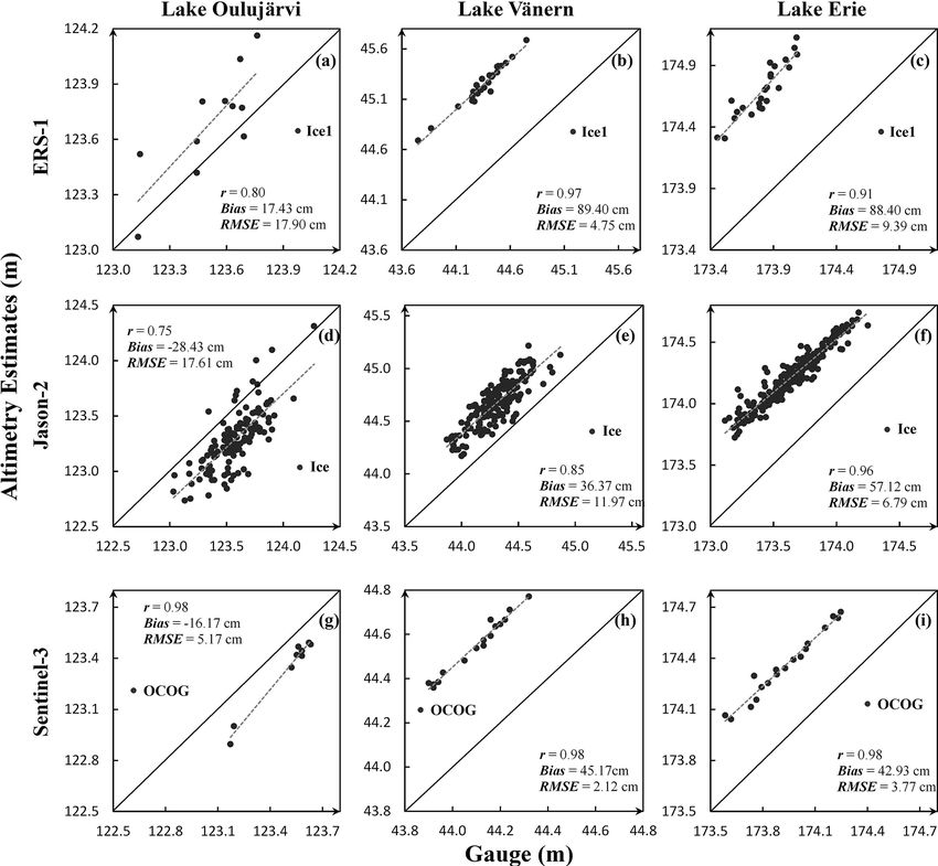
S. Shu et al.: Evaluation of historic and operational satellite radar altimetry missions                                     1645

altimetry-derived water level estimates and the gauge mea-         scribed above, each radar altimetry mission spans different
surements ranged from 9.4 to 13.8 cm. Birkett (1995) as-           time periods and has different levels of measurement accu-
sessed TOPEX/Poseidon over lakes Ontario, Michigan and             racy, and there are systematical differences (biases) between
Superior, and its RMSE ranged from 4.69 to 6.2 cm. Also,           different mission measurements. In order to construct a long-
Birkett et al. (2010) evaluated Jason-2 water level estimates      term consistent time series of lake water level estimates, the
against gauge measurements over five lakes. They found that        question is which radar altimetry mission can be used as a
its RMSE was 2.95 cm for Lake Ontario (with an area of             high-confidence initial reference to remove the biases be-
∼ 20 000 km2 ) and 33.2 cm for Lake Yellowstone (with an           tween missions and to tie different missions together? For a
area of ∼ 350 km2 ). Frappart et al. (2006) investigated the       certain time period, one lake may be visited by multiple radar
performance of the four retrackers of ENVISAT over three           missions. In this case, which satellite radar altimetry mission
small lakes (with an area from 100 to 300 km2 ) near Curuai in     may provide more reliable lake water level estimates? Most
Amazon basin. They observed that the Ice1 retracker was the        radar altimetry missions have several retrackers that can be
best for retrieving lake water levels with ENVISAT altime-         used to estimate lake water level. For a given radar altime-
try observations. Jarihani et al. (2013) compared five differ-     try mission, which retracker is most reliable and accurate for
ent satellite radar altimetry missions (ENVISAT, GFO, T/P,         lake water level retrieval? The pursuit of answers to these
Jason-1, and Jason-2) and assessed the performance of dif-         questions entails a comprehensive and consistent evaluation
ferent retrackers adopted by these missions over Lake Eildon       of all radar altimetry missions over the same set of lakes.
(138 km2 ) and Lake Argyle (1000 km2 ) in Australia. They             In this study, we will examine the performance of all his-
found out that, among the five missions, Jason-2 gave the          torical and currently operational satellite radar altimetry mis-
best results with a RMSE of 28 cm for Ice1 retracker and           sions, except for HY-2A and CryoSat-2 missions. HY-2A
32 cm for MLE3 retracker, while T/P yielded the largest            was excluded from this study because of the difficulty in ob-
RMSE of 150 cm for its sole Ocean retracker. Schwatke              taining its data product (the data are not available online for
et al. (2015a) evaluated the performance of ENVISAT and            public access). The exclusion of CryoSat-2 was due to its
SARAL over the Great Lakes and found that both missions            long repeat cycle orbit that does not allow the production of
can achieve very low RMSE, ranging from 2–6 cm for these           frequent co-located observations for evaluation. Water level
large lakes. Villadsen et al. (2016) reprocessed CryoSat-2         estimates retrieved by different retrackers of the 11 radar al-
data with several non-official retrackers and assessed their       timetry missions will be assessed by using the corresponding
performance over Lake Vänern (5550 km2 ) and Lake Okee-            gauge measurements on 12 lakes of various sizes distributed
chobee (1436 km2 ). They demonstrated that the Multiple            across four countries. After this introductory section, we will
Waveform Persistent Peak (MWaPP) retracker produced the            briefly describe these lakes and the gauge measurements in
lowest RMSE of 9.1 cm over Lake Vänern and 13.4 cm over            Sect. 2. In Sect. 3, we will introduce the data sets collected
Lake Okeechobee. Crétaux et al. (2018) evaluated Sentinel-         by the 11 satellite radar altimetry missions and the differ-
3 and Jason-3 over Lake Issyk-Kul (6236 km2 ), and found           ent retrackers adopted by each mission. Then, in Sect. 4, we
that both missions achieved a very low RMSE of 3 cm with           present the methods for processing the satellite radar altime-
the Ocean retracker. Shu et al. (2020) assessed the perfor-        try data to determine lake water levels. Next, we evaluate
mance of the Sentinel-3 SAR retrackers over 15 lakes, and          each altimetry mission and its retrackers, in comparison with
they reported that the SAR Altimetry Mode Studies and              the gauge measurements in Sect. 5, and discuss the perfor-
Applications-2 (SAMOSA-2) retracker has the lowest mean            mance of each mission and the relevant issues in integrat-
RMSE of 8.08 cm. Jiang et al. (2020) also evaluated four           ing different radar altimetry missions to construct consistent
retrackers (including official and non-official) for Sentinel-     long-term time series in Sect. 6. The research findings are
3 and demonstrated that the MWaPP+ retracker can signif-           summarized in Sect. 7.
icantly improve the accuracy of water level estimates over
large rivers.
   Apparently, each of those previous evaluations only fo-         2     Case study lakes and gauge data
cused on a few of radar altimetry missions. Those individual
evaluations are not strictly comparable, since each study was      2.1    Case study lakes
conducted over a different set of lakes. The differences in
lake size, geographic location, surrounding topography, and        Our case study sites include 12 lakes/reservoirs in four coun-
land cover type could significantly influence the accuracy of      tries (as shown in Fig. 1). The geographic location, the winter
lake water levels retrieved by satellite radar altimeters (Mail-   ice condition, and the gauge station for these lakes are sum-
lard et al., 2015).                                                marized in Table 1. The largest one is Lake Superior in North
   Despite the previous research efforts, many questions re-       America (over 80 000 km2 ), while the smallest one is the
main as to the construction of a long-term time series of wa-      Lokka reservoir in Finland (about 500 km2 ). The three lakes
ter level for ungauged inland lakes, particularly for those lo-    in Finland (Inarijärvi, Lokka, and Oulujärvi) and Lake Cedar
cated in remote areas (e.g., the Arctic coastal plains). As de-    in Canada all have numerous islands scattered within the

https://doi.org/10.5194/hess-25-1643-2021                                        Hydrol. Earth Syst. Sci., 25, 1643–1670, 2021
Evaluation of historic and operational satellite radar altimetry missions for constructing consistent long-term lake water level records
1646                                         S. Shu et al.: Evaluation of historic and operational satellite radar altimetry missions

Figure 1. Geographic distribution of the case study lakes. Lakes are labeled with an identification number listed in Table 1. This figure is
adapted from Fig. 1 in Shu et al. (2020).

Table 1. Geographical characteristics of case study lakes and gauge stations.

                                                              Lakes                                                          Gauge stations
           Index     Name               Country        Lat           Long        Area       Winter ice                Name              Datum
                                                       (◦ )            (◦ )     (km2 )      cover
           1         Inarijärvi                       69.02          27.89       1184       Fully                     Nellim            N2000
           2         Lokka              Finland       67.96          27.63        487       Fully                     Lokka             N2000
           3         Oulujärvi                        64.35          27.21        889       Fully                     Vuottolahti       N2000
           4         Vänern             Sweden        58.91          13.30       5550       None or partly            Vänern            RH00
           5         Great Slave                      61.80      −113.82       27 816       Fully                     Yellowknife       CGVD28
           6         Athabasca          Canada        59.18      −109.34        7781        Fully                     Cracking Stone    CGVD28
           7         Cedar                            53.34      −100.16        2817        Fully                     Oleson Point      CGVD28
           8         Superior                         47.54       −87.76       81 935       Fully or partly           Ontonagon         IGLD85
           9         Huron              US and        44.96       −82.26       59 756       Partly                    Lakeport          IGLD85
           10        Ontario            Canada        43.67       −77.76       19 328       Partly                    Rochester         IGLD85
           11        Erie                             42.16       −81.24       25 691       Fully or partly           Cleveland         IGLD85
           12        Michigan           US            44.01       −86.76       57 399       Partly                    Calumet Harbor    IGLD85

         Note: the areas and geographic coordinates are derived from the Global Lakes and Wetland Databases (GLWD).

lake, fragmenting the water surfaces of these lakes. There-                          each satellite altimetry mission in contrast to the large lakes
fore, the surface condition of these lakes is very similar to                        (e.g., the Great Lakes, Great Slave Lake, and Lake Vänern).
small lakes, over which the satellite radar altimetry signal is                      The boundary polygons of these 12 lakes were obtained from
contaminated easily by the surrounding land surfaces. These                          the Global Lakes and Wetland Databases (GLWD; Lehner
lakes are treated as small lakes to evaluate the performance of

Hydrol. Earth Syst. Sci., 25, 1643–1670, 2021                                                              https://doi.org/10.5194/hess-25-1643-2021
Evaluation of historic and operational satellite radar altimetry missions for constructing consistent long-term lake water level records
S. Shu et al.: Evaluation of historic and operational satellite radar altimetry missions                                    1647

and Döll, 2004). The lake polygons were then used to extract     3   Satellite radar altimetry data products
measurements from each mission in the subsequent analysis.
   A majority of the lakes on Earth are located between          In this study, we evaluate the performance of radar altimeters
45 and 75◦ N (Verpoorter et al., 2014). Those lakes have         on board 11 satellite missions. Those include all historical
varying ice cover conditions in winter seasons, due to the       and currently operational satellite radar altimetry missions,
differences in their latitudes and local climates. Among the     except for HY-2A and CryoSat-2. No data are available from
selected case study lakes, Lake Inarijärvi in Finland is the     the HY-2A mission launched by China. CryoSat-2 operates
northernmost, with a latitude of 69.02◦ , and Lake Erie is       on a long-term repeat orbit (369 d) in order to obtain spatially
the southernmost, with a latitude of 42.16◦ . The three lakes    dense coverage in polar regions, and it is difficult to form fre-
in Finland and the three lakes in Canada are fully ice cov-      quent time series of co-located water level observations for
ered in winter seasons. The ice cover usually lasts more than    inland lakes. Most of the altimetry data products of the 11
7 months for Lake Inarijärvi (Korhonen, 2006) and more than      satellite radar altimetry missions have gone through several
5 months for Great Slave Lake (Howell et al., 2009). The du-     rounds of updating and refinements. We used the most up-
ration of ice cover decreases for the lakes at more southern     to-date version of the data product of each mission for the
locations. In comparison with Canadian lakes, the ice cover      evaluation. The geographical coverage, operational time pe-
on Finnish lakes is often much thinner (Shu et al., 2020) due    riod, repeat cycle, sampling rate, and retrackers of these radar
to the heating effect of the North Atlantic Current (Rahm-       altimetry missions are summarized in Table 2. The temporal
storf, 2003; Korhonen, 2019).                                    coverage and the overlapping time periods of the 11 missions
   Lake Vänern in Sweden and the Great Lakes of North            are illustrated in Fig. 2.
America could be fully covered, partly covered, or totally          Satellite radar altimeters measure elevation through trans-
free from ice in winter seasons, depending on the winter air     mitting radar signal pulses to the nadir surface and timing
temperature. Lake Vänern often remains completely ice free       the echoes. The transmitted and echoed radar pulse is sam-
in winter. From 1979 to 2002, it was only covered by ice in      pled as pulse strength over the elapsed time, which is known
nine winters (Weyhenmeyer et al., 2008). In a cold winter,       as radar altimetry waveform. Most of the 11 missions (ex-
Lake Superior and Lake Erie are often fully covered by ice,      cept for GeoSat, TOPEX/Poseidon, and GFO) adopted two
and the other three (Huron, Ontario, and Michigan) Great         or more retracking algorithms (retrackers) to process the
Lakes are partly covered (Assel and Wang, 2017), while in        echoed waveforms in order to produce accurate elevation
warmer winters all of them are partly covered.                   measurements for different types of Earth surfaces. These re-
                                                                 trackers can be divided into two general categories, namely
2.2   Gauge data                                                 the empirical/model-free retrackers and the physical/model-
                                                                 based retrackers. The model-based retrackers fit a physi-
In situ water level measurements for the 12 lakes were           cally based model to the echoed waveform to produce ele-
collected, respectively, at the gauge stations listed in Ta-     vation measurements. For example, the ENVISAT Ocean re-
ble 1, which are obtained from four online databases.            tracker is based on the Brown (1977) model and the Sentinel-
Those include the Finnish Environment Information Man-           3 ice sheet retracker is based on a five-part piecewise an-
agement System – Hertta – operated by Finnish Envi-              alytical function (MSSL/UCL/CLS, 2019). The model-free
ronment Institute (SYKE) (http://www.syke.fi/fi-FI/Avoin_        retrackers have no assumption on the model of the echoed
tieto/Ymparistotietojarjestelmat, last access: 15 Febru-         waveform, and the examples include the offset center of
ary 2021), the SMHI (Swedish Meteorological and Hy-              gravity (OCOG, also known as Ice1 or ice) developed by
drological Institute; http://vattenwebb.smhi.se/station/, last   Wingham (1986) and the sea ice retracker developed by
access: 15 February 2021), Canada Real-time Hydromet-            Laxon (1994). There are also many efficient non-official re-
ric Data (https://wateroffice.ec.gc.ca/mainmenu/real_time_       trackers (model based or model free) developed in previous
data_index_e.html, last access: 15 February 2021), and the       studies for different surface conditions (Jiang et al., 2020). In
Center for Operational Oceanographic Products and Services       this study, we only focus on the official retrackers that were
(https://tidesandcurrents.noaa.gov/, last access: 15 Febru-      adopted by each mission to generate the official data prod-
ary 2021) operated by NOAA. These gauge stations measure         ucts.
the water-equivalent lake levels when the lake is ice cov-          A total of 10 of the 11 missions (except for Sentinel-3)
ered (Shu et al., 2020). Note that the gauge data are refer-     utilize the conventional pulse-limited altimeter to measure
enced to different datum. In this study, only the gauge data     surface elevation. The diameter of the radar pulse footprint
on the Great Lakes are converted to EGM2008 using the tool       on the Earth’s surface varies from 1.6 to 13.4 km, according
VDatum (https://vdatum.noaa.gov/, last access: 15 Febru-         to the satellite orbit, the echoing surface roughness, and the
ary 2021).                                                       duration of radar pulse (Chelton et al., 1989). Among the 10
                                                                 conventional pulse-limited altimetry missions, SARAL uti-
                                                                 lizes a Ka band (35.75 GHz) as the primary band, with a
                                                                 bandwidth of 480 MHz, to measure the Earth’s surface ele-

https://doi.org/10.5194/hess-25-1643-2021                                     Hydrol. Earth Syst. Sci., 25, 1643–1670, 2021
Evaluation of historic and operational satellite radar altimetry missions for constructing consistent long-term lake water level records
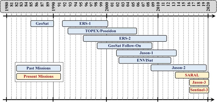
1648                                    S. Shu et al.: Evaluation of historic and operational satellite radar altimetry missions

Figure 2. Timeline of the 11 satellite radar altimetry missions.

vation, while the others use a Ku band (e.g., 13.6 GHz) as           GeoSat data product, instead of the NOAA/NCEI product,
the primary band, with a bandwidth of 320 MHz. Due to                was therefore chosen for the evaluation. At the 1 Hz data
the adoption of the Ka band and the higher bandwidth, the            rate, the sampling interval along the satellite track is 6–
footprint generated by SARAL is about 0.8 times smaller              7 km, depending on the latitude. GeoSat Follow-On (GFO)
than the other Ku-band altimeters for a given pulse length           was launched on 10 February 1998 and ended on 22 Oc-
and orbit altitude (Raney and Phalippou, 2011). Sentinel-3           tober 2008. Since it was a follow-on mission of GeoSat, it
uses a synthetic aperture radar (SAR) altimeter to measure           retained the GeoSat ERM orbit with a repeat cycle of 17 d
the Earth’s surface elevation. This SAR altimetry technology         and covered Earth’s surface between 72◦ N and 72◦ S lati-
decreases the along-track footprint size from several kilome-        tudes along the satellite ground tracks (Naval Oceanographic
ters to about 300 m, which improves the retrieval of elevation       Office and NOAA Laboratory for Satellite Altimetry, 2002).
information over more variable surfaces, e.g., coastal areas         The elevation measurements were produced by the same re-
(Donlon et al., 2012).                                               tracking algorithm used for GeoSat. The georeferenced data
   GeoSat was launched on 12 March 1985 by the US Navy,              were provided at a 10 Hz rate and distributed by US Navy
and its operations consisted of two distinct mission phases,         and NOAA at https://accession.nodc.noaa.gov/0085960 (last
namely the Geodetic Mission (GM) and the Exact Re-                   access: 15 February 2021). With the 10 Hz sampling rate, the
peat Mission (ERM; McConathy and Kilgus, 1987). The                  distance between two adjacent measurements is about 700 m.
GM phase lasted about 18 months, from 31 March 1985                     ERS-1 and ERS-2 were launched by ESA on 17 July 1991
to 30 September 1986, and the ERM phase lasted about                 and 21 April 1995, and retired on 10 March 2000 and
3.5 years, from 8 November 1986 to January 1990. In the              5 September 2011, respectively. ERS-2 was the tandem mis-
GM phase, the satellite operated on a geodetic drifting or-          sion of ERS-1 and carried basically the same set of instru-
bit, while in the ERM phase, it operated on an exact re-             ments on board ERS-1. ERS-1 had eight mission phases
peat orbit, with a repeat cycle of 17 d. In both phases, the         (Phase A, B, R, C, D, E, F, and G) with different re-
satellite collected elevation measurements of the Earth’s sur-       peat cycles during its lifetime (http://www.deos.tudelft.nl/
face between 72◦ N and 72◦ S latitudes. GeoSat used a sin-           ers/phases, last access: 15 February 2021), including the 3 d
gle ocean retracker, based on the Brown (1977) model, to             cycle for the commissioning and the ice phases (phase A,
produce elevation measurements for all different types of the        B, and D), the 35 d cycle for the nominal observation
Earth’s surface (Lillibridge et al., 2006). The georeferenced        phase (phase R, C, and G), and the 168 d cycle for the
measurements were originally provided at a 1 Hz rate by              geodetic drifting phases (phase E and F). ERS-2 had two
the National Centers for Environmental Information (NCEI)            phases, namely the 35 d nominal observation phase (from
at NOAA (https://accession.nodc.noaa.gov/0053056, last ac-           29 April 1995 to 21 February 2011) and the 3 d phase (from
cess: 15 February 2021). For this study, we obtained GeoSat          10 March to 6 July 2011). Elevation measurements col-
data from the Radar Altimeter Database System (RADS;                 lected by both missions cover the Earth’s surface between
Scharroo et al., 2013). RADS provides the most up-to-date            81.5◦ N and 81.5◦ S latitude (Brockley, 2014). After the re-
harmonized geophysical and systematic corrections for all            tirement of ERS-2, the data collected by the two missions be-
the satellite radar altimeters. The limitation of RADS is that       tween August 1991 and July 2003 were reprocessed to gen-
all the data are provided only at 1 Hz rate. Since the origi-        erate an improved homogeneous long-term data set, which
nal georeferenced data were also at the 1 Hz rate, the RADS          is called the REAPER (the REprocessing of Altimeter Prod-

Hydrol. Earth Syst. Sci., 25, 1643–1670, 2021                                        https://doi.org/10.5194/hess-25-1643-2021
S. Shu et al.: Evaluation of historic and operational satellite radar altimetry missions                                                                                                                                                                                                                                                                                                                                               1649

                                                                                                                                                                                                                                                                                                                                                                                             ucts for ERS) products (Brockley et al., 2017). In the repro-
                                                                                                                                                                                                                                                                                                                                                                                             cessing, the four retrackers used for ENVISAT (ocean, Ice1,
                                                                              MWR bands
                                                                                                 (GHz)
                                                                                                                –
                                                                                                                                 23.8, 36.5
                                                                                                                                                                18, 21, 37
                                                                                                                                                                                 23.8, 36.5
                                                                                                                                                                                                  22, 37
                                                                                                                                                                                                                  18.7, 23.8, 34
                                                                                                                                                                                                                                      23.8, 36.5
                                                                                                                                                                                                                                                                     18.7, 23.8, 34
                                                                                                                                                                                                                                                                                                     23.8, 37
                                                                                                                                                                                                                                                                                                                                    18.7, 23.8, 34

                                                                                                                                                                                                                                                                                                                                                                        23.8, 36.5
                                                                                                                                                                                                                                                                                                                                                                                             Ice2 and sea ice) were adopted to refine elevation measure-
                                                                                                                                                                                                                                                                                                                                                                                             ments. Ice1 and sea ice are model-free retrackers developed
                                                                                                                                                                                                                                                                                                                                                                                             by Wingham (1986) and Laxon et al. (1994). The other two
                                                                                                                                                                                                                                                                                                                                                                                             are model-based retrackers. Later, the ERS-2 data were fur-
                                                                                                                                                                                                                                                                                                                                                                                             ther reprocessed by the Centre de Topographie des Océans

                                                                                                                                                                                                                                                                                                                                                                 OCOG, ice sheet, sea ice,
                                                                                                                                 Ice1, Ice2, ocean, sea ice

                                                                                                                                                                                                                                      Ice1, Ice2, ocean, sea ice

                                                                                                                                                                                                                                                                                                     Ice1, Ice2, ocean, sea ice
                                                                                                                                                                                                                                                                                                                                                                                             et de l’Hydrosphère (CTOH) at the Laboratoire d’Etudes
                                                                                                                                                                                                                                                                                                                                                                                             en Géophysique et Océanographie Spatiales (LEGOS; Frap-
                                                                                                                                                                                                                                                                                                                                                                                             part et al., 2016). The CTOH ERS-2 product contains eleva-
                                                                                                                                                                                                                                                                                                                                                                                             tion measurements generated by two retrackers, i.e., Ice1 and

                                                                                                                                                                                                                                                                                                                                                                 SAMOSA-2
                                                                                                                                                                                                                  MLE4, Ice

                                                                                                                                                                                                                                                                     MLE4, ice

                                                                                                                                                                                                                                                                                                                                    MLE4, ice
                                                                                                 Retrackers

                                                                                                                                                                                                                                                                                                                                                                                             Ice2. In this study, we chose the ERS-1 REAPER data prod-
                                                                                                                                                                                 Ice1, Ice2
                                                                              Data product

                                                                                                                                                                                                                                                                                                                                                                                             uct from ESA (https://earth.esa.int/, last access: 15 Febru-
                                                                                                                Ocean

                                                                                                                                                                Ocean

                                                                                                                                                                                                  Ocean

                                                                                                                                                                                                                                                                                                                                                                                             ary 2021) and the further improved ERS-2 data product from
                                                                                                                                                                                                                                                                                                                                                                                             CTOH (http://ctoh.legos.obs-mip.fr/, last access: 15 Febru-
                                                                                                 Rate
                                                                                                                1 Hz
                                                                                                                                 20 Hz
                                                                                                                                                                1 Hz
                                                                                                                                                                                 20 Hz
                                                                                                                                                                                                  10 Hz
                                                                                                                                                                                                                  20 Hz
                                                                                                                                                                                                                                      18 Hz
                                                                                                                                                                                                                                                                     20 Hz
                                                                                                                                                                                                                                                                                                     40 Hz
                                                                                                                                                                                                                                                                                                                                    20 Hz

                                                                                                                                                                                                                                                                                                                                                                        20 Hz
                                                                                                                                                                                                                                                                                                                                                                                             ary 2021) for the evaluation. Both products provide georef-
                                                                                                                                                                                                                                                                                                                                                                                             erenced elevation measurements at a 20 Hz rate. At this data
                                                                                                                                                                                                                                                                                                                                                                                             rate, the distance between two adjacent measurements along
                                                                                                                                                                                                                  AVISO+

                                                                                                                                                                                                                                                                     AVISO+
                                                                                                                                                                                                                                                                                                     AVISO+
                                                                                                                                                                                                                                                                                                                                    AVISO+

                                                                                                                                                                                                                                                                                                                                                                                             the satellite track is about 350 m.
                                                                                                                                                                                                  NOAA
                                                                                                 Source

                                                                                                                                                                                 CTOH
                                                                                                                RADS

                                                                                                                                                                RADS
                                                                                                                                 ESA

                                                                                                                                                                                                                                      ESA

                                                                                                                                                                                                                                                                                                                                                                        ESA

                                                                                                                                                                                                                                                                                                                                                                                                ENVISAT was launched on 28 February 2002, as the suc-
                                                                                                                                                                                                                                                                                                                                                                                             cessor to ERS-1 and ERS-2. In the nominal observation
                                                                                                                                                                                                                                                                                                                                                                                             phase, ENVISAT operated on the same orbit as ERS-1 and
                                                                              Repeat
                                                                                                 cycle
                                                                                                                17 d
                                                                                                                                 35 d
                                                                                                                                                                10 d
                                                                                                                                                                                 35 d
                                                                                                                                                                                                  17 d
                                                                                                                                                                                                                  10 d
                                                                                                                                                                                                                                      35 d
                                                                                                                                                                                                                                                                     10 d
                                                                                                                                                                                                                                                                                                     35 d
                                                                                                                                                                                                                                                                                                                                    10 d

                                                                                                                                                                                                                                                                                                                                                                        27 d

                                                                                                                                                                                                                                                                                                                                                                                             ERS-2, with a 35 d repeat cycle from 2002 to 2010. In Octo-
                                                                                                                                                                                                                                                                                                                                                                                             ber 2010, it was maneuvered to a new orbit, with a repeat cy-
                                                                                                                                                                                                                                                                                                                                                                     81.35◦ N–81.35◦ S

                                                                                                                                                                                                                                                                                                                                                                                             cle of 30 d, to extend its mission lifetime until 8 April 2012.
                                                                                                                              81.5◦ N–81.5◦ S

                                                                                                                                                                              81.5◦ N–81.5◦ S

                                                                                                                                                                                                                                   81.5◦ N–81.5◦ S

                                                                                                                                                                                                                                                                                                  81.5◦ N–81.5◦ S

                                                                                                                                                                                                                                                                                                                                                                                             This new phase is referred to as the extension phase. In
                                                                                                              72◦ |,N–72◦ S

                                                                                                                                                              66◦ N–66◦ S

                                                                                                                                                                                                72◦ N–72◦ S
                                                                                                                                                                                                                66◦ N–66◦ S

                                                                                                                                                                                                                                                                   66◦ N–66◦ S

                                                                                                                                                                                                                                                                                                                                  66◦ N–66◦ S

                                                                                                                                                                                                                                                                                                                                                                                             both phases, the elevation measurements were provided at an
                                                                              Geographic
                                                                                                 coverage

                                                                                                                                                                                                                                                                                                                                                                                             18 Hz rate, with a sampling interval of about 370 m along the
                                                                                                                                                                                                                                                                                                                                                                                             satellite ground track. ENVISAT mission used four retrack-
                                                                                                                                                                                                                                                                                                                                                                                             ers (ocean, Ice1, Ice2, and sea ice) to generate elevation mea-
                                                                                                                                                                                                                                                                                                                                                                                             surements for different types of the Earth’s surface. In 2018,
                                                                                                                                                                                                                                                                     NASA, CNES, NOAA, EUMETSAT

                                                                                                                                                                                                                                                                                                                                    NASA, CNES, NOAA, EUMETSAT

                                                                                                                                                                                                                                                                                                                                                                                             the ENVISAT altimetry data were reprocessed and released
                                                                                                                                                                                                                                                                                                                                                                                             by ESA as the ENVISAT V3 product. We obtained this most
                                                                                                                                                                                                                                                                                                                                                                                             recent version 3 product from ESA (https://earth.esa.int/, last
Table 2. The 11 satellite radar altimetry missions and their data products.

                                                                                                                                                                                                                                                                                                                                                                                             access: 15 February 2021) for the evaluation.
                                                                                                                                                                                                                                                                                                                                                                                                SARAL is a joint altimetry mission of CNES (Space
                                                                                                                                                                                                                                                                                                                                                                                             Agency of France) and ISRO (Indian Space Research Or-
                                                                                                                                                                NASA, CNES

                                                                                                                                                                                                                  NASA, CNES

                                                                                                                                                                                                                                                                                                                                                                                             ganisation). It was launched on 25 February 2013 by ISRO
                                                                                                                                                                                                                                                                                                     CNES, ISRO
                                                                              Organization

                                                                                                                                                                                                                                                                                                                                                                                             and is the first satellite mission with a Ka-band (35.75 GHz)
                                                                                                                US Navy

                                                                                                                                                                                                  US Navy

                                                                                                                                                                                                                                                                                                                                                                                             radar altimeter on board (Frappart et al., 2015; Bonnefond et
                                                                                                                                 ESA

                                                                                                                                                                                 ESA

                                                                                                                                                                                                                                      ESA

                                                                                                                                                                                                                                                                                                                                                                        ESA

                                                                                                                                                                                                                                                                                                                                                                                             al., 2018). During its exact repetitive phase from the launch
                                                                                                                                                                                                                                                                                                                                                                                             to 4 July 2016, SARAL flew on ENVISAT nominal orbit
                                                                                                                                 10 Mar 2000

                                                                                                                                                                                                  22 Oct 2008

                                                                                                                                                                                                                                                                                                                                                                                             with a 35 d exact repeat cycle. Due to technical issues with
                                                                                                                                                                                                                                      8 Apr 2012
                                                                                                                                                                                 5 Sep 2011
                                                                                                                                                                9 Oct 2005

                                                                                                                                                                                                                                                                     1 Oct 2019
                                                                                                                1 Jan 1990

                                                                                                                                                                                                                  1 Jul 2013

                                                                                                                                                                                                                                                                                                                                                                                             the reaction wheels, the repetitive orbit has no longer been
                                                                              Operational time

                                                                                                                                                                                                                                                                                                                                                                                             maintained since 4 July 2016, and the orbit of the satel-
                                                                                                 End

                                                                                                                                                                                                                                                                                                                                                                                             lite decayed naturally, leading to irregular drifting ground
                                                                                                                                                                                                                                                                                                     –
                                                                                                                                                                                                                                                                                                                                    –

                                                                                                                                                                                                                                                                                                                                                                        –

                                                                                                                                                                                                                                                                                                                                                                                             tracks on the Earth’s surface. This new phase is known as the
                                                                                                                                                                10 Aug 1992
                                                                                                                12 Mar 1985

                                                                                                                                                                                 21 Apr 1995

                                                                                                                                                                                                                                                                                                                                                                 25 Apr 2018
                                                                                                                                                                                                  10 Feb 1998

                                                                                                                                                                                                                                      28 Feb 2002

                                                                                                                                                                                                                                                                                                     25 Feb 2013

                                                                                                                                                                                                                                                                                                                                                                 16 Feb 2016
                                                                                                                                                                                                                                                                     20 Jun 2008

                                                                                                                                                                                                                                                                                                                                    17 Jan 2016
                                                                                                                                 17 Jul 1991

                                                                                                                                                                                                                  7 Dec 2001

                                                                                                                                                                                                                                                                                                                                                                                             SARAL drifting phase (Dibarboure et al., 2018). The four
                                                                                                                                                                                                                                                                                                                                                                                             ENVISAT retrackers (Ice1, Ice2, sea ice, and ocean) were
                                                                                                 Start

                                                                                                                                                                                                                                                                                                                                                                                             adopted by SARAL in the creation of different data prod-
                                                                                                                                                                                                                                                                                                                                                                                             ucts for different types of the Earth’s surfaces. The data are
                                                                                                                                                                                                                                                                                                                                                                                             provided at a rate of 40 Hz by AVISO+ (Archiving, Val-
                                                                                                                                                                                                                                                                                                                                                                 Sentinel-3A
                                                                                                                                                                                                                                                                                                                                                                 Sentinel-3B
                                                                                                                                                                                                                                      ENVISAT

                                                                                                                                                                                                                                                                                                                                                                                             idation and Interpretation of Satellite Oceanographic data)
                                                                                                                                                                                                                                                                                                     SARAL
                                                                              Mission

                                                                                                                                                                                                                  Jason-1

                                                                                                                                                                                                                                                                     Jason-2

                                                                                                                                                                                                                                                                                                                                    Jason-3
                                                                                                                GeoSat
                                                                                                                                 ERS-1

                                                                                                                                                                                 ERS-2

                                                                                                                                                                                                                                                                                                                                                                                             at the CNES (https://aviso-data-center.cnes.fr/, last access:
                                                                                                                                                                                                  GFO
                                                                                                                                                                T/P

                                                                                                                                                                                                                                                                                                                                                                                             15 February 2021). The distance between two adjacent mea-

               https://doi.org/10.5194/hess-25-1643-2021                                                                                                                                                                                                                                                                                                                                                  Hydrol. Earth Syst. Sci., 25, 1643–1670, 2021
1650                                 S. Shu et al.: Evaluation of historic and operational satellite radar altimetry missions

surements along the satellite track is about 180 m. In this       adjacent measurements is about 350 m. We obtained the al-
study, we only evaluated the SARAL data collected in the          timetry data products of these three missions from AVISO+
exact repetitive phase.                                           for the evaluation.
   TOPEX/Poseidon (T/P), Jason-1, Jason-2, and Jason-3 are           The Sentinel-3 mission consists of two identical satellites,
four continuous missions that provide long-term consistent        i.e., the Sentinel-3A and Sentinel-3B, which were launched
altimetry observations of the Earth’s surface along the same      on 16 February 2016 and 25 April 2018, respectively. The
fixed ground tracks. The operation of each satellite is usu-      ground tracks of Sentinel-3B fall exactly in the middle of the
ally composed of two phases, namely the phase with nom-           ground tracks of Sentinel-3A. In other words, the Sentinel-
inal orbit and the phase with interleaved orbit (Fu et al.,       3B is operated on an interleaved orbit and in parallel with the
1994). Both orbits have an exact repeat cycle of 10 d and         Sentinel-3A on the nominal orbit. The two orbits have the
cover Earth’s surface between 66◦ N and 66◦ S latitudes.          same 27 d repeat cycle and collect elevation measurements
Each satellite in this series firstly flies on the nominal or-    along their ground tracks between 81.35◦ N and 81.35◦ S lat-
bit after its launch, and was usually maneuvered to a new         itudes (Donlon et al., 2012). Both satellites carry a synthetic
orbit a number of months after the launch of its succes-          aperture radar altimeter instrument (SRAL) for the elevation
sor satellite. The ground tracks generated by this new or-        measurements. The SRAL works primarily on the synthetic
bit phase are on the midway between its nominal ground            aperture radar (SAR) mode with the low resolution mode
tracks; hence, the new orbit is referred to as interleaved or-    (LRM) as a backup (https://sentinel.esa.int/web/sentinel/
bit. The period between the launch of the successor satellite     user-guides/sentinel-3-altimetry/resolutions/sampling, last
and the maneuver of the predecessor satellite is often called     acess: 15 February 2021). A total of four retrackers are
the tandem phase. During this phase, the two satellites fly on    used in the SAR mode to produce elevation measurements,
the same orbit, separated by 60–70 s (see the Jason-3 prod-       including SAR Altimetry Mode Studies and Applications-
uct handbook). TOPEX/Poseidon was launched on 10 Au-              3 (SAMOSA-2), offset center of gravity (OCOG), sea ice,
gust 1992 and then maneuvered to the interleaved orbit on         and ice sheet (MSSL/UCL/CLS, 2019). The OCOG (also
15 August 2002 after the launch of Jason-1 on 7 Decem-            known as Ice1) is a model-free retracker developed by
ber 2001. TOPEX/Poseidon was decommissioned on 9 Oc-              Wingham (1986). The other three are model-based fully
tober 2005. The TOPEX/Poseidon data products were gen-            analytic or semi-analytic retrackers. Due to the high rate
erated with their sole Brown-model-based retracker (herein        of missing data (Shu et al., 2020), the sea ice retracker is
after referred to as the ocean retracker; Rodríguez and Mar-      not included for the evaluation in this study. The elevation
tin, 1994) for all different types of surfaces. In the original   measurements are provided at a rate of 20 Hz. The interval
TOPEX/Poseidon data products, the geographic coordinates          between two adjacent measurements along the satellite
were provided for the 1 Hz elevation measurements. In this        track is about 300 m (https://sentinel.esa.int/web/sentinel/
study, we utilized the data products created by RADS for the      user-guides/sentinel-3-altimetry/resolutions/sampling, last
evaluation. The distance between two adjacent 1-Hz mea-           acess: 15 February 2021). We obtained the Sentinel-3
surements along the satellite track is about 6 km. Jason-1        altimetry data from the ESA Copernicus Open Access Hub
was shifted to the interleaved orbit on 10 February 2009, af-     (https://scihub.copernicus.eu/, last acess: 15 February 2021)
ter the launch of Jason-2 on 20 June 2008. Jason-1 stayed         for the evaluation.
on the interleaved orbit for 3 years until 7 May 2012 when           In this study, the altimetry data collected by each mission
it was adjusted to a geodetic orbit. It was finally decom-        in geodetic phase (or drifting phase) are not included in the
missioned on 1 July 2013. Jason-2 was transferred to the          evaluation. In the geodetic phase, the drifting ground tracks
interleaved orbit on 17 October 2016, after the launch of         do not generate frequent observations for a specific lake to
Jason-3 on 17 January 2016. It maintained the interleaved         form a time series of water level measurements. In this study,
orbit for 8 months and then transferred to a geodetic orbit       for all the completed missions, only the data collected in their
on 10 July 2017. It was decommissioned on 1 October 2019.         exact repeat phase are used for the evaluation. For instance,
Jason-3 is now operating on the nominal orbit. A total of two     the data collected in the ERM phase were used for GeoSat
retrackers have been used by all three missions to generate       and the data collected in phases R, C, and G were used for
elevation measurements, i.e., the Brown-model-based MLE4          ERS-1. In the extension phase of the ENVISAT mission and
retracker for ocean surfaces and the model-free ice retracker     in the intermittent phases of TOPEX/Poseidon, Jason-1, and
(similar to OCOG/Ice1 retracker) for non-ocean surfaces (see      Jason-2 missions, the satellites all operated on an exact re-
the Jason-1, 2, and 3 product handbook for details). Another      peat orbit. Therefore, the data collected in these phases were
Brown-model-based retracker MLE3 has also been adopted            also included in the evaluation. For the two currently opera-
for Jason-2 and Jason-3. Due to its apparent inferior perfor-     tional missions, i.e., Sentinel-3 and Jason-3, the observations
mance in comparison with MLE4 (Thibaut et al., 2010; Vu           for longer than a full year (including winter and summer)
et al., 2018), it is not included for our evaluation. All three   are used for the evaluation, including Jason-3 data between
of these radar altimetry missions provide elevation measure-      February 2016 and March 2018 and Sentinel-3 data between
ments at a rate of 20 Hz. The ground distance between two         June 2016 and September 2017.

Hydrol. Earth Syst. Sci., 25, 1643–1670, 2021                                      https://doi.org/10.5194/hess-25-1643-2021
S. Shu et al.: Evaluation of historic and operational satellite radar altimetry missions                                      1651

   In addition to the altimeter instrument, most of the 11         2016; Crétaux et al., 2009; Scharroo and Smith, 2010).
satellite missions (except for GeoSat) also carried a pas-         Many global atmospheric models have been used to quan-
sive microwave radiometer (MWR) to simultaneously mea-             tify the biases induced by the three atmospheric components
sure the brightness temperature (referred to as TB ) of Earth’s    at different locations and times. For the ionospheric correc-
surface. The microwave bands adopted by each mission are           tion (1Riono ), it has been recommended to use the NIC09
listed in Table 2.                                                 (New Ionosphere Climatology) model for the radar altime-
                                                                   try measurements acquired before September 1998 (Schar-
                                                                   roo and Smith, 2010) and to use the GIM (global ionosphere
4     Lake water level determination and accuracy                  map) model for the measurements acquired after that time
      evaluation methods                                           (Iijima et al., 1999). For the dry and the wet tropospheric
                                                                   corrections (1Rdry and 1Rwet ), the three most commonly
The method used to determine lake water level from satel-
                                                                   used atmospheric models are produced by the European Cen-
lite radar altimetry in this study consists of three technical
                                                                   tre for Medium-Range Weather Forecasts (ECMWF) and
data processing steps. First, the surface elevation measure-
                                                                   the National Centers for Environmental Prediction (NCEP).
ments are retrieved from altimetry data products of the 11
                                                                   Those include the ECMWF model (Miller et al., 2010),
satellite missions for the 12 case study lakes, and the most re-
                                                                   the ECMWF Re-Analysis Interim (ERA) model (Dee et al.,
cent release of the altimetry data products with the up-to-date
                                                                   2011), and the NCEP model (Caplan et al., 1997). The mag-
geophysical corrections has been used. Second, spurious sur-
                                                                   nitude of the dry and the wet tropospheric corrections de-
face elevation measurements are filtered out through statisti-
                                                                   pends linearly on the height of the surface over which the
cal analysis, and the remaining valid surface elevation mea-
                                                                   altimetry measurement is made. The higher the surface ele-
surements within a lake are statistically aggregated to deter-
                                                                   vation, the smaller the magnitude of the dry and the wet tro-
mine lake water level at different time points. Third, the ice
                                                                   pospheric correction terms. The difference between the dry
cover condition is examined using the simultaneous TB mea-
                                                                   tropospheric corrections computed at the sea surface, with
surements from the MWR instruments, and those lake water
                                                                   an elevation of 0 m, and at the land surface, with an elevation
level estimates during the ice-covered period are excluded
                                                                   of 5000 m, could be as high as 1 m (Fernandes et al., 2014).
in the subsequent accuracy evaluations. To evaluate the per-
                                                                   Fernanders and Lázaro (2016) also developed a new algo-
formance of each satellite altimeter and its retrackers, three
                                                                   rithm to improve the wet tropospheric corrections that can
accuracy measures, including the Pearson’s correlation coef-
                                                                   be applied to different radar altimetry missions. In this study,
ficient r, the bias and the RMSE, have been calculated by
                                                                   since we focus mainly on the official data products generated
comparing the radar-altimetry-derived lake water level esti-
                                                                   by each satellite mission, we adopted the dry and the wet tro-
mates with the corresponding gauge measurements.
                                                                   pospheric corrections that were contained in the official data
4.1    Retrieval of lake surface elevation measurements            products and were computed with the height of the surface
                                                                   where the altimetry measurements were taken. Table 3 lists
Following Crétaux et al. (2017), the surface elevation is de-      the version of each altimetry data product and the models of
termined for each satellite radar altimetry mission according      the three atmospheric corrections utilized in this study.
to Eq. (1) as follows:
                                                                   4.2   Statistical determination of lake water levels
hretrk = H − Rretrk − 1Riono + 1Rwet + 1Rdry
                                                                   The 12 lakes in this study were all overpassed by the 11 satel-
                             
       +1RsolidEarth + 1Rpole − Geoid,                      (1)
                                                                   lite radar altimetry missions. The number of each mission’s
where hretrk is the surface elevation generated by a retracker,    ground tracks on these lakes is determined by the size of the
H is the height of satellite orbit, Rretrk is the range be-        lake and the satellite orbit. The large lakes (e.g., Lake Supe-
tween the satellite and the nadir Earth’s surface generated        rior) usually have multiple ground tracks for each mission,
by a retracker, 1Riono , and 1Rwet , and 1Rdry compen-             while the small lakes (e.g., Lokka reservoir) may have only
sate for the delay of the radar pulse due to the ionosphere,       one ground track for a satellite mission. For a large lake (e.g.,
the wet troposphere, and the dry troposphere, respectively.        the Great Lakes), strong wind, big wave, diurnal tide, geoid
1RsolidEarth and 1Rpole are for solid Earth tide correction        undulation, and other factors may significantly influence lake
and pole tide correction, and geoid converts the reference         water level at different locations in the lake. The in situ wa-
surface from ellipsoid to geoid (orthometric height). In this      ter level measurements from a gauge station may not reflect
study, the geoid model EGM2008 (Pavlis et al., 2012) is            the actual water level of those ground tracks far away from
adopted.                                                           the gauge station. Thus, the overall RMSE of the altimetry-
   Due to the variable nature of the Earth’s atmosphere, the       derived estimates will increase when altimetry observations
three atmospheric components (1Riono , 1Rwet , and 1Rdry )         from distant ground tracks are included for the evaluation
have significant influence on the accuracy of altimetry mea-       (Birkett, 1995). To minimize the possible influence of wind,
surements (Fernandes et al., 2014; Fernandes and Lázaro,           waves, tide, and other environmental factors for an objec-

https://doi.org/10.5194/hess-25-1643-2021                                       Hydrol. Earth Syst. Sci., 25, 1643–1670, 2021
1652                                   S. Shu et al.: Evaluation of historic and operational satellite radar altimetry missions

Table 3. The version of altimetry data product and the models of the three atmospheric corrections.

                         Mission       Data         Version          Ionospheric     Wet              Dry
                                       source                        correction      tropospheric     tropospheric
                                                                     (1Riono )       correction       correction
                                                                                     (1Rwet )         (1Rdry )
                         GeoSat        RADS         –                NIC09           ERA              ERA
                         ERS-1         ESA          REAPER           NIC09           ERA              ERA
                         T/P           RADS         GDR-M            NIC09, GIM      ERA              ERA
                         ERS-2         CTOH         CTOH             NIC09, GIM      ERA              ERA
                         GFO           NOAA         GDR              GIM             NCEP             NCEP
                         Jason-1       AVISO+       GDR-E            GIM             ERA              ERA
                         ENVISAT       ESA          V3               GIM             ECMWF            ECMWF
                         Jason-2       AVISO+       GDR-D            GIM             ECMWF            ECMWF
                         SARAL         AVISO+       GDR-T            GIM             ECMWF            ECMWF
                         Jason-3       AVISO+       GDR-D            GIM             ECMWF            ECMWF
                         Sentinel-3    ESA          Baseline 2.45    GIM             ECMWF            ECMWF

tive comparison between different satellite missions, we thus           repeating phase, we extracted the surface elevation measure-
select the ground track nearest to the gauge station and ex-            ments along a ground track falling within lakes using lake
clude distant ground tracks in the performance evaluation, as           polygons from the GLWD. Considering the footprint size of
listed in Table 4. CryoSat-2 uses a geodetic orbit (long-term           the radar pulses over relatively homogeneous surface (usu-
repeat orbit). It is difficult to form a frequent time series of        ally 1–2 km) and the seasonal fluctuation of lake surface
co-located water level estimates for the evaluation. Although           area, only elevation measurements over 2 km away from the
a time series of water level estimates from CryoSat-2 obser-            polygon boundary are selected. Then, the extracted eleva-
vations can be derived for a large lake by including many               tion measurements along each ground track were combined
different ground tracks, this will inevitably introduce uncer-          to form a surface elevation profile, which was examined to
tainties to the evaluation due to the factors explained above.          filter out the spurious measurements with the robust median
This is the reason that we did not include the CryoSat-2 data           absolute deviation (MAD) statistic (Shu et al., 2018, 2020;
and the data collected by other satellite missions during their         Liu et al., 2012). The spurious measurements deviate signif-
geodetic phases or drifting phases.                                     icantly from the other measurements of the lake surface ele-
   The total number of completed cycles for each mission de-            vation profile. The MAD method calculates a statistic score
pends on its operational lifetime and the temporal length of            for each measurement of the surface elevation profile to in-
a repeat cycle. For a mission with a long lifetime and short            dicates its deviation from the rest of the measurements. The
repeat cycle, the overpass number could be much higher. As              higher the score, the stronger deviation is. The measurements
listed in Table 4, TOPEX/Poseidon has the highest number                with a score value larger than or equal to three are excluded.
of complete cycles (333 in the nominal phase and 111 in the             The median of the remaining elevation measurements along
intermittent phase). In each repeat cycle, there is one satellite       the track is then used as the estimate of the lake water level
overpass along the selected ground track for each mission.              on the day of each satellite overpass. Finally, the time series
   Spurious elevation measurements could be generated                   of water level estimates were evaluated through comparison
when the satellite ground track passes over lake islands or             with the concurrent gauge measurements.
when it is close to the lake shore. In particular, the complex
surrounding topography could have considerable influences               4.3   Identification of lake level estimates affected by ice
on the elevation measurements over very small lakes (width                    cover
less than 2 km) or over rivers, when considering the tracking
modes (e.g., the open/closed loop of Sentinel-3 and Jason-
                                                                        Lakes located in a high latitude in this study are more fre-
3) and the receiving window sizes (e.g., the three different
                                                                        quently overpassed by satellite missions, but the ice cover on
window sizes of ENVISAT) of the radar altimeter (Jiang
                                                                        these lakes in the winter season may introduce significant er-
et al., 2020; Biancamaria et al., 2018). The smallest case
                                                                        rors to the elevation measurements of satellite altimetry mis-
study lake in our evaluation is the Lokka reservoir in Fin-
                                                                        sions. It has been demonstrated that the lake ice cover in win-
land, with a surface area of about 500 km2 . For each mis-
                                                                        ter could have strong influences on the radar altimetry sig-
sion, the ground track over the lake is at least 10 km long.
                                                                        nal pulse, resulting in lower elevation measurements than the
In this study, two steps were adopted to minimize the in-
                                                                        real lake surface elevation (Birkett and Beckley, 2010; Ziyad
fluences. First, for each satellite overpass during the exact
                                                                        et al., 2020). The mechanism on how lake ice deforms the

Hydrol. Earth Syst. Sci., 25, 1643–1670, 2021                                             https://doi.org/10.5194/hess-25-1643-2021
Table 4. The indices of ground tracks selected for each satellite mission over each lake.

                                                                    Mission                         Inarijärvi       Lokka       Oulujärvi        Vänern        Great Slave        Athabasca         Cedar   Superior   Huron   Ontario   Erie   Michigan
                                                  Name              Phase              Cycles
                                                  GeoSat            Nominal                  67         367           104                397        399                     28                 228   198         168      293       52    368         24

https://doi.org/10.5194/hess-25-1643-2021
                                                  ERS-1             Nominal                  32         197           283                541        846                   570                  409   912          93       80      493    751         93
                                                                    Nominal                333            –             –                239        144                   223                   95   178         254      117       15    193         41
                                                  T/P
                                                                    Intermittent           111            –             –                116        220                    45                  171   195          76      152       50    152        254
                                                  ERS-2             Nominal                  90         197           283                541        846                   570                  409   912          93       80      493    751         93
                                                  GFO               Nominal                180          367           104                397        399                     28                 228   198         168      293       52    368         24
                                                                    Nominal                259            –             –                239        144                   223                   95   178         254      117       15    193         41
                                                  Jason-1
                                                                    Intermittent           113            –             –                116        220                    45                  171   195          76      152       50    152        254
                                                                    Nominal                  89         197           283                541        846                   570                  409   912          93       80      493    751         93
                                                  ENVISAT
                                                                    Extension                19         169           399                543        648                   802                   37   312         512      224      581    409         52
                                                                    Nominal                304            –             –                239        144                   223                   95   178         254      117       15    193         41
                                                  Jason-2
                                                                    Intermittent            23            –             –                116        220                    45                  171   195          76      152       50    152        254
                                                  SARAL             Nominal                  34         197           283                541        846                   570                  409   912          93       80      493    751         93
                                                                                                                                                                                                                                                            S. Shu et al.: Evaluation of historic and operational satellite radar altimetry missions

                                                  Jason-3           Nominal                  78           –             –                239        144                   223                   95   178         254      117       15    193         41
                                                  Sentinel-3        Nominal                  18         272           386                  72       358                   682                   54   766         549      422      222    650        736

                                                Note that there are no T/P and Jason overpasses for Lake Inarijärvi and Lokka, since their geographic coverage is up to a latitude of 66◦ N.

Hydrol. Earth Syst. Sci., 25, 1643–1670, 2021
                                                                                                                                                                                                                                                            1653
1654                                 S. Shu et al.: Evaluation of historic and operational satellite radar altimetry missions

Sentinel-3 altimetry signal pulse and fails the official wave-     Since the data of the altimetry-derived water levels and
form retracking algorithms has been investigated in Shu et         the gauge measurements were consistent only for the Great
al. (2020). Shu et al. (2020) also developed a non-official cor-   Lakes, as mentioned in Sect. 2.2, we compared and evaluated
rection algorithm to accurately retrieve the water-equivalent      the biases of all the retrackers of the 11 missions for these five
lake levels in ice-covered condition from Sentinel-3 altimetry     lakes. The Pearson correlation coefficient r indicates each
observations. Since the official retrackers of all the satellite   retracker’s capability in depicting lake water level temporal
altimetry missions (not only Sentinel-3) are not designed to       variation. A high r value shows that the retracker captures
handle the ice cover on lakes, we identified and excluded the      the lake water level variation very well. Note that the corre-
measurements obtained in the ice-covered condition in order        lation coefficient r is not affected by systematic errors/biases
to have a fair comparison between different altimetry mis-         or vertical datum differences. In our evaluation, the RMSE is
sions.                                                             calculated after the bias of each retracker over each lake was
   In this study, we followed the method in Shu et al. (2020)      removed (Shu et al., 2020). The RMSE, hence, represents
to examine the ice cover condition for all satellite radar al-     the relative accuracy (precision) of the altimetry-derived lake
timetry missions over the case study lakes. In other words,        level estimates. By removing the bias, the inconsistency be-
we examine the temporal variations of brightness tempera-          tween the vertical data of the altimetry-derived water levels
ture (TB ) over lake surface to detect the lake ice cover. Simi-   and the gauge measurements would not affect RMSE values,
lar to the pre-processing of radar altimetry surface elevation     making all the retrackers over the 12 lakes comparable to
measurements, we first filter the simultaneous microwave           each other in terms of RMSE value.
TB measurement profile along the track over a lake. Then, all
the remaining valid microwave TB measurements were aver-
aged to represent the temperature for the day of each satellite    5     Results
overpass. The time series curve of TB was then analyzed to
determine the dates of ice on and ice off for each winter, in-     5.1    Radar altimetry-derived lake water level estimates
dicated by the sudden increase and rapid decrease in TB on
the curve. Those radar altimetry measurements collected in         Figure 3 shows the time series of TB and altimetry-derived
the ice-covered condition were identified and then excluded        water levels over Great Slave Lake collected by ENVISAT,
from the subsequent evaluations.                                   Jason-2, and Sentinel-3 in the winters of 2003–2004, 2011–
                                                                   2012, and 2016–2017, respectively. The ice-covered duration
4.4    Accuracy measures for the performance evaluation            is determined by the sudden increase and the decrease in TB ,
                                                                   as indicated by the vertical dashed lines in Fig. 3a–c. The
The performance of a satellite altimetry mission and its re-       similar temporal variation of TB was also observed for other
trackers were evaluated in terms of three accuracy mea-            satellite missions over other lakes when they were covered
sures as in Shu et al. (2020), including the Pearson’s cor-        by ice. As shown in Fig. 3d–f, the lake water level estimates
relation coefficient (r), the bias, and the root mean square       during the ice-covered periods deviate significantly from the
error (RMSE). The bias and the RMSE were computed as               gauge measurements, while, during the ice-free seasons, the
below.                                                             lake water level estimates correlate very well with the gauge
        n                                                         measurements.
     1X       i         i
                            
Bias =      Hretrk − Hgauge                                 (2)       Table 5 summarizes the number of lake level estimates
     n i=0                                                         during ice-free (open water) and ice-covered seasons over
                                                                   each lake for each retracker of the 11 missions. For some
       v
       u n 
       u1 X                            2
RMSE = t            i
                 Hretrk     i
                        − Hgauge − Bias ,                   (3)    satellite missions, the number of valid lake water level esti-
          n i=0                                                    mates over a certain lake during ice-free season was too small
                                                                   to perform an evaluation. For example, the number of GeoSat
where n is overpasses along the selected track on a lake, i is     estimates over Lake Inarijärvi, Lokka, Lake Oulujärvi, and
                              i
the index of an overpass, Hretrk  is the altimetry-derived lake    Lake Cedar are all less than three. Therefore, the evaluation
level estimate for satellite overpass i given by a specific re-    of GeoSat over these lakes was not conducted. As shown in
               i
tracker, and Hgauge  is the concurrent gauge measurement at        Table 5, the total number of lake water level estimates (sum
the time of overpass i.                                            of the ice-covered number and the ice-free number) for some
   These three accuracy measures are computed for each re-         satellite missions, such as GeoSat and GFO, are consider-
tracker of each mission over each lake. The bias represents        ably smaller than the number of completed orbit cycles due
the systematic (positive or negative) difference between the       to satellite data loss. The reasons for satellite data loss could
series of altimetry-derived estimates and the gauge mea-           be the malfunction of the sensor, the maneuver of the satel-
surements. If both are referenced to the same vertical da-         lite during the phase transition, the failure of the retracker
tum (e.g., EGM2008), then the smaller the bias, the closer         to reach convergence when processing complex waveforms
altimetry-derived estimates are to the real lake water level.      (e.g., multi peaks) from inhomogeneous reflecting surfaces

Hydrol. Earth Syst. Sci., 25, 1643–1670, 2021                                       https://doi.org/10.5194/hess-25-1643-2021
You can also read