Impact Craters Unit Plan - Satellite Educators Association
←
→
Page content transcription
If your browser does not render page correctly, please read the page content below

Impact
Craters
Unit
Plan

Part 4

More Lessons from the Sky
Satellite Educators Association
https://SatEd.org
Please see the Acknowledgements section for historical contributions to the development
of this lesson plan. This form of “Impact Craters Unit Plan – Part 4” was published in
February 2013 in “More Lessons from the Sky,” a regular feature of the SEA Newsletter,
and archived in the SEA Lesson Plan Library. Both the Newsletter and the Library are
freely available on-line from the Satellite Educators Association (SEA) at this address:
https://SatEd.org.

Content, Internet links, and support material available from the online Resources page
revised and updated October 2021.

                  SEA Lesson Plan Library Improvement Program
Did you use this lesson plan with students? If so, please share your experience to help
us improve the lesson plan for future use. Just click the Feedback link at
https://SatEd.org/library/about.htm and complete the short form on-line. Thank you.
Teaching Notes

Impact Craters
Part 4 (of 4)

Invitation
Two boys, aged 9 and 13, stood in one’s front yard after riding bikes during the summer
of 1991 when they heard a low-pitched whistle getting louder. Then they saw a rock
zoom past them and land on the ground about 4 meters away making a hole about 5
centimeters deep. They looked around but could find no evidence that anyone had
thrown the rock. When they picked up the rock it felt warm. What was it? Where did it
come from? Why was it warm? How fast was it going to make such a hole in the ground?
How did it form? How did it get there? Were the boys in danger? So many questions and
no answers yet. What should happen next? What questions do you have about the
event? How might these questions be investigated?

                   Grade Level:                    5-8
                   Time Requirement:               6-8 class periods (all four parts)
                   Prerequisites:                  Impact Craters – Parts 1-3
                   Relevant Disciplines:           Science, Mathematics, Geography

Student Learning Outcomes (unit of four lessons)
By the end of this unit, students should be able to do the following:
   • Work in cooperative research teams of 3 to 4
   • Generate questions for scientific investigation
   • Plan and conduct a scientific investigation of a selected question
   • Collect, analyze, and interpret data about impact craters
   • Create an individual learning log or journal containing collected information,
      drawings of objects or landscapes studied, selected research questions, data
      gathered, analysis of all data, interpretations, and explanations, inferences,
      predictions about large impact craters on earth and the likelihood of another big
      impact
   • Design and present to the class a team report based on the team members’
      individual learning logs

Lesson Description
This lesson is the fourth in a unit plan called “Impact Craters.” It addresses grades 5-8
standards in Physical Science, Earth Science, mathematics, geography, scientific
inquiry, language arts (writing and oral communication), and teamwork. Overall, six to
eight sequential class periods are suggested although the series can be adapted by the
teacher to fit the individual curriculum calendar. In this unit plan, learners are guided
to inquire about impact craters visible in satellite images of the Earth.

What each part includes
Each part of the lesson plan series for the unit includes Teaching Notes and Student
Activity files. The Teaching Notes are generally the same for each part but vary with

More Lessons from the Sky, © Satellite Educators Association, Inc.                      Impact Craters-4   1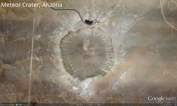
Teaching Notes

particulars for the lessons described in that part. The Student Activity pages contain
material for students for the lessons described in each part. A complete summary of all
four parts can be found in the Teaching Notes for Part 1.

Part 4
“Crater Hunters” (Lesson 7 from Exploring Meteorite Mysteries), consists of two activities.
In Activity A: “Where Are the Craters on Earth?” learners inspect images of craters on
the Moon, Mars, Venus, and Meteor Crater in Arizona then map the locations of selected
impact craters on Earth. A world map of impact sites is produced using ArcGIS Online,
a free on-line geographic information system program from ESRI, or by hand-plotting
the map on paper. Next, learners write a description of three impact Craters on Earth
based on the collected data for each including the modeling data from the previous
lesson. Then they view satellite-based images of the actual craters they just described
and write new descriptions based on the new visual information. Activity B, “Crater
Hunters,” involves each team planning an expedition to suspected impact crater site to
discover additional information to help decide if the selected area really is an impact
site. Teams present their expedition proposals to the class. The Teaching Notes include
a lesson plan for each activity. The Student Activity pages include duplication masters
for the impact crater data table, a world map, student procedure sheets, and response
worksheets. Further guidelines for the team research and presentations, and class
closure are found in Part 1 and Part 4.

                   Impact Craters Unit - Suggested Eight-Day Schedule
 Start
          Length   Part                                       Description
  On
 Day                      Introduction - presented by teacher
           1 day    1
   1
           1 day          Impact Craters Learning Center – student-centered. The learning center
    Day
             or     2     should be available throughout the entire unit for learners to visit individually
    2-7
           more           and no more than 3 at a time.
                          Modeling Impact Craters – student team-centered. Lesson 6 “Impact Craters”
    Day     1-2
                    3     from Exploring Meteorite Mysteries. Allow two days. If learners finish in less time,
    2-5    days
                          they can visit the learning center. Must precede Crater Hunters.
                          Crater Hunters – student team-centered. Lesson 7 “Crater Hunters” from
    Day     1-2           Exploring Meteorite Mysteries. Two activities: mapping and expedition planning.
                    4
    3-6    days           Allow two days. If learners finish in less time, they can visit the learning center.
                          Must follow Modeling Impact Craters.
                          Independent research – student team-centered. Learners further explore their
    Day     1-2
                   1-4    selected question for investigation by completing 1 or 2 more of the lessons from
    5-6    days
                          Exploring Meteorite Mysteries.
                          Preparation & Rehearsal for Team Presentation – Each team considers how
    Day
           1 day    1     it will present their investigated questions and conclusions. They prepare their
     7
                          report and rehearse.
                          Team Presentations & Class Closure – After each team delivers its report to
    Day
           1 day    1     the class, the teacher guides the class to complete the final column of the class
     8
                          KWL chart – what did we Learn?

Important Terms
          Impact crater          Longitude                Latitude                      Weathering
          Erosion                Deposition               Volcanism                     Tectonic
          Terrain                Geophysical              Tektites                      Vaporize

2     Impact Craters-4                               More Lessons from the Sky, © Satellite Educators Association, Inc.
Teaching Notes

Assessment Suggestions (unit of four lessons)
  • Teamwork and participation in groups
  • Progress toward development of content, study habits, thinking skills
  • Adequate completion of at least three lessons in the unit between the Introduction
          and team report to the class
     •    Quality, accuracy, completeness of activities from the learning center
     •    Quality, accuracy, completeness of the individual learning log or journal
     •    Quality, accuracy, completeness of the team’s presentation to the class

Next Generation Science Standards Addressed (unit of four lessons)
The Next Generation Science Standards below are relevant to this lesson. The standards
for all four lessons in the unit are listed.

Performance Expectations & Disciplinary Core Ideas
Grade 5: Motion and Stability: Forces and Interactions – Types of Interactions
   PE- 5-PS2-1 – Support an argument that the gravitational force exerted by Earth on
        objects is directed down.
   DCI- 5-PS2.B – The gravitational force of Earth acting on an object near Earth's
        surface pulls that object toward the planet's center.

Grades 6-8: Motion and Stability: Forces and Interactions – Forces and Motion
   PE- MS-PS2-1 – Apply Newton's Third Law to design a solution to a problem
        involving the motion of two colliding objects.
   DCI- MS-PS2.A – For any pair of interacting objects, the force exerted by the first
        object on the second object is equal in strength to the force that the second
        object exerts on the first, but in the opposite direction.

Grades 6-8: Motion and Stability: Forces and Interactions – Types of Interactions
   PE- MS-PS2-4 – Construct and present arguments using evidence to support the
        claim that gravitational interactions are attractive and depend on the masses
        of interacting objects.
   DCI- MS-PS2.B – Gravitational forces are always attractive. There is a gravitational
        force between any two masses, but it is very small except when one or both of
        the objects have large masses.

Grades 6-8: Energy – Conservation of Energy and Energy Transfer
   PE- MS-PS3-5 – Construct, use, and present arguments to support the claim that
        when the kinetic energy of an object changes, energy is transferred to or from
        the object.
   DCI- MS-PS3.B – When kinetic energy of an object changes, there is inevitably some
        other change in energy at the same time.

Grades 6-8: Earth's Place in the Universe: Earth and the Solar System
   PE- MS-ESS1-2 – Develop and use a model to describe the role of gravity in the
        motions within galaxies and the solar system.
   DCI- MS-ESS1.B – The solar system consists of the sun and a collection of objects,
        including planets, their moons, and asteroids that are held in orbit around the
        sun by its gravitational pull on them.

More Lessons from the Sky, © Satellite Educators Association, Inc.   Impact Craters-4   3
Teaching Notes

Grades 6-8: Earth and Human Activity: Natural Hazards
   PE- MS-ESS3-2– Analyze and interpret data on natural hazards to forecast future
        catastrophic events and inform the development of technologies to mitigate
        their effects.
   DCI- MS-ESS3.B– Mapping the history of natural hazards in a region, combined with
        an understanding of related geologic forces, can help forecast the locations and
        likelihoods of future events.

Grades 6-8: Engineering Design: Defining and Delimiting Engineering Problems
   PE- MS-ETS1-1– Define the criteria and constraints of a design problem with
        sufficient precision to ensure a successful solution, taking into account relevant
        scientific principles and potential impacts on people and the natural
        environment that may limit possible solutions.
   DCI- MS-ETS1.A– The more precisely a design task’s criteria and constraints can be
        defined, the more likely it is that the designed solution will be successful.
        Specification of constraints includes consideration of scientific principles and
        other relevant knowledge likely to limit possible solutions.

Science and Engineering Practices
   − Define a design problem that can be solved through the development of an object,
      tool, process, or system and includes multiple criteria and constraints, including
      knowledge that may limit possible solutions.
   − Develop and use a model to describe phenomena.
   − Analyze and interpret data to determine similarities and differences in findings.
   − Apply scientific ideas or principles to design an object, tool, process, or system.
   − Construct and present oral and written arguments supported by empirical
      evidence and scientific reasoning to support or refute an explanation or a model
      for a phenomenon or a solution to a problem.
   − Support an argument with evidence, data, or a model.

Cross Cutting Concepts
   − Graphs, charts, and images can be used to identify patterns in data.
   − Cause and effect relationships are routinely identified and used to explain change.
   − Models can be used to represent systems and their interactions—such as inputs,
     processes, and outputs—and energy and matter flows within systems.
   − Energy may take different forms (e.g., energy in fields, thermal energy, energy of
     motion).
   − The uses of technologies and limitations on their use are driven by individual or
     societal needs, desires, and values; by the findings of scientific research; and by
     differences in such factors as climate, natural resources, and economic
     conditions.

Preparation (Part 4: “Crater Hunters”)
Preparation for Activity A: “Where Are the Craters on Earth?”
      1. Gather materials.
      2. Review the slides in Craters.ppt. If needed, print the PowerPoint Notes Pages.
         They have information about each slide and some directions for use.
      3. Review the tutorial Using ArcGIS Online. Try it yourself.

4   Impact Craters-4                        More Lessons from the Sky, © Satellite Educators Association, Inc.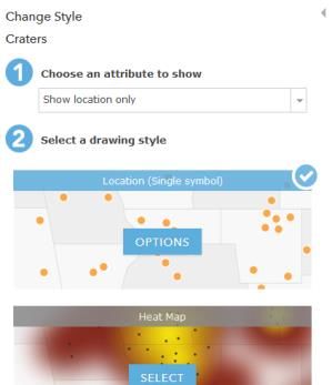
Teaching Notes
4. Duplicate for distribution the documents listed in Materials below.
Materials for Activity A
PowerPoint file Craters.ppt
A means to display the PowerPoint slides to the class or each learner group –
usually a computer with monitor output to a projector or similar arrangement.
The same setup can be used to project ArcGIS Online and its map as seen in
the Further Analysis section of Using ArcGIS Online tutorial if each team does
not have its own computer.
A printed copy of the Note Pages from the PowerPoint file with slide
descriptions, directions for use, and source data
Student Procedure for Activity A and Activity B (one per learner or learner
group)
Craters on Earth Data Chart (one per learner or learner group)
If using computers, an Internet-enabled computer for each learner group
If using computers, either the file Craters.csv pre-loaded on each computer or
access to Microsoft Excel or similar spreadsheet program that can save a
worksheet as a comma-delimited file (*.csv)
If using computers, Using ArcGIS Online tutorial for each learner or learner
group
If NOT using computers, Crater Hunters Map (one per learner or learner
group)
If NOT using computers, a variety of atlases and maps to help define the
terrain of the three sites on Impact Crater Descriptions worksheet
Impact Crater Descriptions worksheet (one per learner)
Where Are the Craters on Earth answer sheet (one per learner)
If video projector connected to computer is not available: An overhead
projection transparency of the black line master completed world map.
Procedure for Activity A
1. Show PowerPoint slides of Mercury, Venus, Moon, and Mars found in
Craters.ppt. These can be projected for the entire class or loaded onto each
learner group’s computer.
2. Discuss how these bodies are alike and how they are different, focusing on
cratering.
3. Ask, “Where are the craters on Earth?” Show the slides of Meteor Crater in
Arizona.
4. Divide students into teams of up to 4 per computer terminal.
5. According to the materials list above, distribute the following:
a. Student Procedure for Activity A and Activity B
b. Craters on Earth Data Chart-GIS or Craters on Earth Data Chart
c. Craters.csv, if needed
d. Using ArcGIS Online tutorial or Crater Hunters Map
e. Impact Crater Descriptions worksheet
f. Where Are the Craters on Earth answer sheet
More Lessons from the Sky, © Satellite Educators Association, Inc. Impact Craters-4 5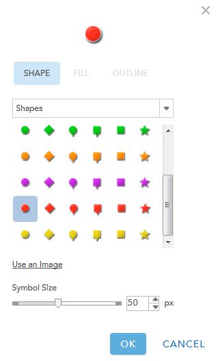
Teaching Notes

      6. The original Craters on Earth Data Chart is sufficient for students who will
         plot the locations of impact craters by hand on a paper map. If using ArcGIS
         Online, however, more precise location data are needed. Craters.csv is a
         comma delimited file for use with ArcGIS Online. Location data in this file are
         at least three orders of magnitude more precise. If students are to make their
         own comma delimited files with spreadsheet software, use the data listed on
         Crater on Earth Data Chart-GIS.

      7. Guide students through production of world map of impact craters. If using
         computers, Questions 1-2 on the Where Are the Craters on Earth answer
         sheet should be answered as learner teams come to them in the tutorial.

      8. When the maps are finished, conduct a brief class discussion to review and
         insure each group is on target. Have learners inspect the terrain around
         Clearwater Lakes, Manicouagan, and Spider Crater impact sites (especially if
         using ArcGIS Online where they can zoom in on each impact site). A
         screenshot of the completed map in ArcGIS Online is included in Craters.ppt
         for you to project, or you make an overhead projection transparency of the
         blackline master included in these Teaching Notes. Provide atlases and
         topographic maps for those without computers.

      9. Have learners complete the Location column and Description (based on info)
         column on the Impact Crater Descriptions worksheet. Again, briefly discuss
         to review and highlight well written descriptions. Invite students to clarify
         their descriptions, if desired.

      10. Show the slides of the craters described on the worksheet and have learners
          complete the Further Analysis section of the ArcGIS Online tutorial or utilize
          atlases and maps to further define the terrain in the areas of the three sites.
          Be sure they answer Questions 3-7. This step provides additional information
          about each of these three impact crater sites using space-based imagery. This
          last section of the tutorial adds imagery and detailed aerial views not available
          in the PowerPoint slides. If the computer projecting the PowerPoint slides is
          Internet-enabled, it can also project ArcGIS Online. In so doing, all students
          can benefit from the visual details presented in the Further Analysis section.

      11. Ask learners how this new information might change their written
          descriptions of three sites on their worksheets. Ask them to revise their
          descriptions based on the new information and complete the last column on
          their Impact Crater Descriptions worksheet.

      12. As a closure for Activity A, show the last PowerPoint slide of the Earth and
          share the information in the Note Pages. Then ask learners to answer
          Questions 8-11 on Where Are the Craters on Earth answer sheet. Briefly,
          review and discuss.

Preparation for Activity B: “Crater Hunters”
   1. Gather materials.
   2. Insure both you and the learners read the background materials.
   3. Duplicate sufficient copies of Background Information for Crater Hunters.

6   Impact Craters-4                        More Lessons from the Sky, © Satellite Educators Association, Inc.
Teaching Notes
Materials for Activity B
Impact Crater-4 Activity B: Background Information for Crater Hunters (one
per learner or learner group)
Sufficient materials of the type needed for the research, proposal writing, and
presentation by learner teams. The materials will be guided by the number of
students in your class, grade level, and other special considerations of learner
needs and your classroom situation.
Procedure for Activity B
1. Read and discuss with class, Activity B: Background Information for Crater
Hunters.
2. Lead class in a brainstorming session to determine potential research sites
around the globe where indications of impact craters might be found. If
needed, review the slides in the PowerPoint file Craters.ppt, data from Activity
A, and modeling data from Impact Craters Part 3.
3. Once essential characteristics of an impact site have been reviewed from the
brainstorming results, assign each team a different map area to observe as it
looks for any feature that might indicate the site of an impact. Allow students
to be very creative in choosing the possible sites. Specific sites are not
important. Students are likely to choose obviously round structures such as
lakes in Canada, Hudson Bay, the Gulf of Mexico, the Aral Sea in Uzbekistan,
Lake Okeechobee in Florida, and Lake Victoria in Africa.
4. Each learner group must plan geologic field investigations and laboratory
tests that might be done to verify that their designated crater is or is not an
impact site. Ask learners, “What would you look for at the site to help prove
that you have found the remnants of an impact?” Possible answers might
include the following:
a. Look for meteorites
b. Map the geologic formations looking for a basin shape, overturned rim
layers, possible uplift in the central crater region, and/or multiple ring
structures
c. Look for minerals changed by impact shocks
d. Look for melted rocks
e. Test deposits associated with the debris from the crater, looking for
elements that are much more abundant in meteorites (i.e. iridium)
5. Each team will prepare and present a short “proposal” asking for support
money to conduct its research. Each will need to explain and justify the
planned research. They should consider time, travel, personnel, laboratory
expenses, and data gathering. The actual format of the report can be any
suitable medium - a flipchart, a poster, a PowerPoint presentation or whatever
method best suits your students and classroom situation.
ArcGIS Online (ArcGIS.com Map viewer) is provided by ESRI without charge with full
use of the interactivity of map layers. Users can add data to maps, adjust the appearance
of map symbols, measure area and distance, find location, and print maps. Saving and
sharing maps requires login. Registering for an ESRI Global Account is fast and easy
More Lessons from the Sky, © Satellite Educators Association, Inc. Impact Craters-4 7Teaching Notes
online. A major benefit for account holders is access to cloud storage and the ability to
share maps with others. It is highly recommended that teachers establish their own
ESRI accounts for ArcGIS Online.
A note about the brainstorming in Activity B. Brainstorming is an activity that promotes
equal participation, student interactions, and effective communication. It can be teacher
led with the results consistently visible to the entire class. It is often more effective when
done in smaller cooperative learning groups where each member of the group has a
defined role, then pool the results in a teacher led discussion. One of the more
important characteristics of brainstorming is that all suggestions are valued without
judgment and added to the overall list of potential solutions. Once all ideas have been
listed, then all members of the group acting together make a logical and rational decision
about which of the listed ideas is most likely to effectively solve the problem or answer
the overarching question. For more information about brainstorming, the following web
sites might be helpful:
_____. “Assessing Projects: Gauging Student Needs, Brainstorming.” Intel Teach
Program. Retrieved September 2021 from
https://www.intel.com/content/dam/www/program/education/us/en/docum
ents/assessing-projects/strategies/gauging-brainstorming.pdf
_____. “Kagan’s Articles.” Kagan Publishing & Professional Development. Retrieved
September 2021 from https://www.kaganonline.com/free_articles/
In preparation for the team reports, it is helpful to give students guidelines to follow in
preparing their reports. The guidelines could be in the form of a copy of assessment
rubrics the teacher will use to assess the presentations or a checklist. Sample
assessment rubrics for teamwork, oral presentations, and PowerPoint presentations are
included in the Teaching Notes for Part 1.
One way to insure each student listens respectfully to the team reports is to require
each audience member to ask questions. Learners can note questions they have about
the presentation in their learning logs or journals during each team report. Encourage
students to ask reasonable questions after listening carefully to the presentation. The
questions could be seeking more information about a particular or clarification of a
certain point. Give every learner ample opportunity to ask at least one question about
at least one presentation.
These Teaching Notes pages are provided in portable document format (.pdf). Adobe
Reader or a similar pdf reader is required to access the .pdf file. Adobe Reader can be
downloaded free of charge from the Adobe web site listed in the Reference section. The
Student Activity pages are provided in Microsoft Word document (.doc) format allowing
the teacher to more easily adapt the student pages to the specific needs of the learners
and the teacher’s unique classroom situation.
Your specific implementation of this lesson will depend on your own curriculum
calendar, the subject discipline with which you associate the lesson series, the level and
needs of your students, and your particular classroom situation.
Background (Crater Hunters)
8 Impact Craters-4 More Lessons from the Sky, © Satellite Educators Association, Inc.Teaching Notes
The complete background information about impact craters can be found in Teaching
Notes Part 1. A more thorough treatment of impact craters and lesson planning involving
impact craters can be found in NASA’s 1997 publication Exploring Meteorite Mysteries.
This document is now in the public domain and can be freely copied and distributed.
See the Reference Section for download sites. The following has been extracted from
Lesson 7 of that document:
Impact craters are geologic structures formed when a meteorite, asteroid or comet
smashes into a planet or other solid body. All the terrestrial planets and satellites have
been bombarded throughout their history. To us the most obvious examples of these
impacts are the craters on the Moon. If the Moon is visible, craters are visible. You can
only see the very large craters or basins with the naked eye. Lunar craters were not
described until after Galileo used one of the first telescopes to look at the Moon. Modern
binoculars help to make the craters on the Moon very obvious.
On Earth, dynamic geology forces have erased most of the evidence of its impact history.
Weathering, erosion, deposition, volcanism, and tectonic activity have left only a small
number of impacts identifiable. Approximately 140 terrestrial impact craters have been
identified. These impact craters range from about 1 to over 200 kilometers in diameter
and from recent to about two billion years in age.
Acknowledgements (unit)
This lesson plan series was inspired by an original lesson developed by Linda Green and
distributed under the title “Meteorites” in Lessons from the Sky, a compilation of more
than fifty lesson plans published by the Satellite Educators Association, copyright 1995,
Amereon, Ltd. The original lesson was suggested for grades 3-5.
While inspired by Green’s original publication, this lesson sequence is designed for
grades 5-8. It was taken largely from NASA’s Exploring Meteorite Mysteries developed for
grades 5-12 in 1997 by a team led by Marilyn Lindstrom of NASA’s Johnson Space
Center, and included Jaclyn Allen, Allan Treiman, Carl Allen, and Anita Dodson, then
of Lockheed Martin Space and Engineering Co., and teachers Joanne Burch, Karen
Crowell, Roy Luksch, Karen Stocco, Bobbie Swaby, and Kay Tobola. The document is
now in the public domain and can be freely copied and distributed. It contains many
lesson ideas applicable in many subject areas and adaptable to almost all grade levels.
The teacher is invited to download and examine Exploring Meteorite Mysteries to create
other implementation scenarios.
The current form of this unit plan is adaptable to grades 9-12.
Special thanks to Dr. Paula Arvedson of the Charter College of Education at California
State University, Los Angeles, for the extra time and research that went into developing
the detailed guidelines for the Impact Craters Learning Center about the Russian
Mystery. Thanks to the same institution for its offering of sample assessment rubrics.
This lesson update and this edition of Teaching Notes were developed by J.P. Arvedson
for the Satellite Educators Association as part of More Lessons from the Sky published
on-line each month in the Satellite Educators Association Newsletter. More information
about the Satellite Educators Association, its annual Satellites & Education Conference
for educators, international environmental research collaborative for students, and free
More Lessons from the Sky, © Satellite Educators Association, Inc. Impact Craters-4 9Teaching Notes access to its monthly online Newsletter can be found at https://SatEd.org. All More Lessons from the Sky lesson plans are archived in the on-line SEA Lesson Plan Library available at https://SatEd.org. The web site features a description of the library contents, Next Generation Science Standards addressed, several search tools for finding lessons easily, separate resource files for lessons where needed, and the library’s Analysis Toolbox. Please credit all contributors to the lesson when duplicating or otherwise using any portion of this lesson or its associated materials. Resource Links (unit of four lessons) Note: All of these URLs were current and active as of this writing. If any are unreachable as printed, the use of on- line search engines such as DuckDuckGo, Google, or Bing, is suggested to find current links. _____. “Adobe Reader.” Adobe. Adobe Systems Incorporated. Retrieved September 2021 from https://get.adobe.com/reader/ _____. ArcGIS. ESRI. Retrieved September 2021 from http://www.arcgis.com/home/index.html A free, on-line geographic information system to which you can add your data, such as impact crater locations, to a selection of basemaps _____. “Assessing Projects: Gauging Student Needs, Brainstorming.” Intel Teach Program. Retrieved September 2021 from https://www.intel.com/content/dam/www/program/education/us/en/document s/assessing-projects/strategies/gauging-brainstorming.pdf _____. Center for Meteorite Studies. Arizona State University. Retrieved September 2021 from https://meteorites.asu.edu/ _____. Exploring Meteorite Mysteries. A Teacher’s Guide with Activities for Earth and Space Science. National Aeronautics and Space Administration. Retrieved September 2021 from https://er.jsc.nasa.gov/seh/Exploring_Meteorite_Mysteries.pdf Complete Teacher’s Guide and lesson plans in PDF. _____. Exploring Meteorite Mysteries Slide Set with Script. National Aeronautics and Space Administration. Retrieved September 2021 from https://er.jsc.nasa.gov/seh/meteorslides.pdf Complete guide to the entire slide set for Exploring Meteorite Mysteries _____. “Dawn, A Journey to the Beginning of the Solar System.” Jet Propulsion Laboratory, National Aeronautics and Space Administration. Retrieved September 2021 from https://solarsystem.nasa.gov/missions/dawn/overview/ Other web sites with information about the Dawn mission include: https://www.nasa.gov/mission_pages/dawn/main/index.html and https://www.nasa.gov/mission_pages/dawn/ceresvesta/index.html 10 Impact Craters-4 More Lessons from the Sky, © Satellite Educators Association, Inc.
Teaching Notes

_____. Download Google Earth. Google Earth. Retrieved September 2021 from
   https://www.google.com/earth/versions/#download-pro
   Download Google Earth Pro or access web-based Google Earth app

_____. “Kagan’s Articles.” Kagan Publishing & Professional Development. Retrieved
   September 2021 from https://www.kaganonline.com/free_articles/

_____. “Mud Splat Craters” lesson plan. Solar System Exploration, National Aeronautics
   and Space Administration. Retrieved September 2021 from
   https://mars.jpl.nasa.gov/classroom/pdfs/MSIP-MarsActivities.pdf
   Modeling craters lesson plan using thick mud; source of impact crater drawings

_____. “Near Earth Orbit Program.” National Aeronautics and Space Administration.
   Retrieved September 2021 from https://cneos.jpl.nasa.gov/faq/
   Frequently Asked Questions about the NEO Program

_____. “Lesson Titles/Resources for Lessons.” SEA Lesson Plan Library, Satellite
   Educators Association, Inc. Retrieved September 2021 from
   https://SatEd.org/library/Resources.htm

_____. “Rubric for PowerPoint Presentation.” Scholastic.com. Retrieved September
   2021 from https://www.scholastic.com/content/dam/teachers/lesson-
   plans/migrated-files-in-body/rubic.pdf

_____. “Stardust, NASA’s Comet Sample Return Mission.” Jet Propulsion Laboratory,
   National Aeronautics and Space Administration. Retrieved September 2021 from
   https://stardust.jpl.nasa.gov/overview/index.html
   Gateway to Stardust mission educational materials, background, news archives

National Research Council. A Framework for K-12 Science Education: Practices,
   Crosscutting Concepts, and Core Ideas. Washington, DC: The National Academies
   Press, 2012. Retrieved September 2021 from
   https://www.nap.edu/catalog/13165/a-framework-for-k-12-science-education-
   practices-crosscutting-concepts

National Research Council. Next Generation Science Standards For States, By States.
   Washington, DC: The National Academies Press, 2013. Retrieved September 2021
   from
   https://www.nap.edu/catalog/18290/next-generation-science-standards-for-
   states-by-states

Answers to Questions from Activity A: “Where Are the Craters on Earth?”
1. How many markers appear on the map?
     There should be 18 markers corresponding to the 18 impact sites listed in the Data Chart. This question
     is a quick check for accuracy in following the tutorial so far and should be checked by the teacher during
     Activity A.

2. Where is North America in the screen display?
     North America should be more or less centered vertically on the left side of the screen display. This

More Lessons from the Sky, © Satellite Educators Association, Inc.             Impact Craters-4            11
Teaching Notes
question is a quick check for accuracy in following the tutorial so far.
3. What can you see in this image that you could not see in the other map?
Students should report observing more ground detail of the impact crater sites referring to possible
locations of the crater wall, rim, and rays of ejecta.
4. How does the size of the marker change as you zoom in?
The marker size remains constant with respect to the size of the screen and relative to other markers
when graduated by size. The marker size will not change with changes in map scale when zooming in
or out.
5. Does the map marker appear to be in the correct location when viewed from a
global view scale?
No. The map marker is nearby but completely outside the obvious crater that formed Manicouagan
Reservoir.
6. What can you do to insure the map marker is correctly placed when the map is
viewed at the zoomed-in scale? (Hint: In your Craters on Earth Data chart, compare
the listing of latitude and longitude for Clearwater Lakes to the listing of latitude and
longitude for all other impact sites.)
The latitudes and longitudes could be expressed more precisely with more decimal places or minutes
and seconds rather than whole degrees only. That should place the map marker more accurately when
the map is viewed at a zoomed-in scale.
7. How does this information change the way you would use the measurement tool to
inspect impact crater sites on the map?
Answers will vary. One must either estimate the actual center of the impact site from apparent
geological features or more precisely express latitude and longitude in the Craters on Earth Data chart
to begin with. In truth, there may be so much weathering and other degradation to the original impact
crater that estimating more precise latitude and longitude will have to be accomplished by comparing
trial and error results and with the existing topography.
8. Where are the craters on Earth?
Answers will vary. Students will likely report locations listed in the Data Chart.
9. What happened to the craters on Earth?
Impact craters on Earth have been subjected to faulting and other crustal movements, volcanic
eruptions, weathering and erosion from wind and water, and burial by soil and/or water.
10. What are some differences between Moon craters and Earth craters?
Impact craters on Moon are visually obvious compared to those on Earth. The Moon has little
atmosphere thus no major effects of weathering or erosion by wind or water. Volcanic action on Moon
has, thus far, been minor compared to Earth. Evidence of many Moon impact craters has been buried
by superposition of material from more recent impacts in the same areas.
11. Compare several Earth craters. How are they alike and different?
Answers will vary depending on the craters selected. Look for consideration of terrain, geophysical
effects, and geologic processes.
12 Impact Craters-4 More Lessons from the Sky, © Satellite Educators Association, Inc.Teaching Notes Some Impact Crater Sites on Earth More Lessons from the Sky, © Satellite Educators Association, Inc. Impact Craters-4 13
Teaching Notes

                        (This page is intentionally blank.)

14   Impact Craters-4                   More Lessons from the Sky, © Satellite Educators Association, Inc.
Student Activity
Impact Craters-4
Crater Hunters
Introduction
Impact craters are geologic structures formed when a meteorite, asteroid or
comet smashes into a planet or other solid body. All the terrestrial planets and
satellites have been bombarded throughout their history. To us the most obvious
examples of these impacts are the craters on the Moon. If the Moon is visible,
craters are visible. You can only see the very large craters or basins with the
naked eye. Lunar craters were not described until after Galileo used one of the
first telescopes to look at the Moon. Modern binoculars help to make the craters
on the Moon very obvious.
On Earth, dynamic geologic forces have erased most of the evidence of its impact
history. Weathering, erosion, deposition, volcanism, and tectonic activity have
left only a small number of impacts identifiable. Approximately 140 terrestrial
impact craters have been identified. These impact craters range from about 1 to
over 200 kilometers in diameter and from recent to about two billion years in
age.
Image source: http://www.lpi.usra.edu/publications/slides/craters/slide_10.html
Part 4 has two activities. In Activity A, “Where Are the Craters on Earth,” you will
first look at other bodies in the solar system for evidence that the entire inner
solar system has a history of impacts. Then, focusing on Earth, you will map the
locations of a number of impact sites around the world. After describing the sites
based on your collected data and map, you will compare your descriptions with
aerial and satellite pictures of each crater.
In Activity B, “Crater Hunters,” you will use your documents from Activity A to
More Lessons from the Sky, © Satellite Educators Association, Inc. Impact Craters-4 15Student Activity
identify another possible impact crater site. Then working with your team, plan
an expedition to that site to determine if it really is an impact crater or a physical
feature of the Earth’s surface formed by other actions.
Preparation
To accomplish Activity A: “Where Are the craters on Earth?” you will need the
following materials:
(1) A copy of the Procedure (below) for Activity A and Activity B
(2) The PowerPoint file Craters.ppt
(3) The Craters on Earth Data Chart
(4) Crater Hunters Map or Using ArcGIS Online tutorial with an Internet-
enabled computer
(5) Impact Crater Descriptions: Activity A worksheet
(6) Activity A Where Are the Craters on Earth answer sheet.
For Activity B: “Crater Hunters” you will need these materials:
(1) The Procedure
(2) Background Information for Crater Hunters
(3) materials for research and preparation of your team presentation as
recommended by your teacher.
Procedure
Activity A: “Where Are the Craters on Earth?”
Following your teacher’s instructions, accomplish these tasks in this order:
1. Gather your materials.
2. Review the images of impact craters on Mercury, Venus, Moon, and Mars.
Discuss with your classmates and teacher how these bodies are alike and
how they are different. Focus your attention on cratering.
3. Review the image of the Barringer Crater near Winslow, Arizona (“Meteor
Crater”). Propose and discuss possible answers to the question, “Where
are the craters on Earth?”
4. Plot the locations of selected impact craters on Earth. Use either ArcGIS
Online, a free online geographic information system (GIS) program for
making and printing maps, or use a blank world map available from your
teacher. If using an Internet enabled computer, follow directions in Using
ArcGIS Online tutorial.
5. As you work through the tutorial, be sure to answer Questions 1-2 on the
answer sheet.
6. Based on the age, size, name, and terrain, write a description of Spider
Crater, Manicouagan, and Clearwater Lakes impact sites using the Impact
Crater Descriptions worksheet. When finished, you should have completed
all but the right-hand column of the worksheet.
16 Impact Craters-4 More Lessons from the Sky, © Satellite Educators Association, Inc.Student Activity
7. Inspect the closer images of these three impact sites. Do this using both
of the following tools:
a. View and discuss slides of three impact sites in Craters.ppt PowerPoint
file.
b. Complete the Further Analysis section of the GIS tutorial.
c. Answer Questions 3-7 on the answer sheet.
8. In the right-hand column of the worksheet, try writing revised descriptions
of each of these impact craters based on the new information you
discovered upon closer inspection with newer, satellite-based imagery.
9. Answer Questions 8-11 on your answer sheet. Use well-written, complete
sentences that express complete thoughts.
Activity B: “Crater Hunters”
Following your teacher’s instructions, accomplish these tasks in this order:
1. Gather your materials including those from Impact Craters Parts 1, 2, and
3 as well as from Part 4 Activity A.
2. Read Activity B: Background Information for Crater Hunters.
3. Following your teacher’s guidelines, discuss Background Information.
Review observations made in Activity A. If needed, review the slides in the
PowerPoint file Craters.ppt. You will be asked to brainstorm an example
crater and possible investigation of its existence.
4. Your teacher will assign a map area to investigate. Look for any feature
that might be the site of an impact.
5. Plan a geologic field investigation and laboratory tests that might be done
to verify that the site you have selected is or is not a meteorite impact site.
6. Prepare and present a short “proposal” asking for support money to
conduct your research. You will need to explain and justify the planned
research. Consider time, travel, personnel, laboratory expenses, and data
gathering. Try to answer the question, “What would you look for at the site
to help prove that you have found the remnants of an impact?”
7. Your teacher will give you more guidelines for your presentation including
a timeline and due date.
More Lessons from the Sky, © Satellite Educators Association, Inc. Impact Craters-4 17Craters on Earth Data
More Lessons from the Sky, © Satellite Educators Association, Inc.
For Impact Craters-4, Activity A: “ Where Are the Craters on
Earth?”
Chart
Impact Craters-4
Student Activity
18
NOTE: Manicouagan diameter rounded from 70-100 km to 80 km. Sikhote Alin in Russia broke up prior to impact leaving no discernible impact diameter.Name ______________________________________ Date _________________ Class____________
For Impact Craters-4, Activity A: “ Where Are the Craters on
Earth?”
Crater Hunters Map
More Lessons from the Sky, © Satellite Educators Association, Inc. Impact Craters-4 19Craters on Earth Data - GIS
More Lessons from the Sky, © Satellite Educators Association, Inc.
For Impact Craters-4, Activity A using ArcGIS Online
Chart
Impact Craters-4
Student Activity
20
NOTE: Manicouagan diameter rounded from 70-100 km to 80 km. Sikhote Alin in Russia broke up prior to impact leaving no discernible impact diameter.
Latitudes and longitudes checked with United States Meteorite Impact Craters, Planetary and Space Science Center, and Google Earth.Student Activity
Using ArcGIS Online
Activity A: Where Are the Craters on Earth?
Preparing Your Data
The information on the Data Chart must be saved in a comma-delimited file (.csv)
before plotting your map using a geographic information system (GIS). The file
can be made using a spreadsheet program such as Microsoft Excel.
Ensure your computer has Microsoft Excel or similar spreadsheet program installed.
Launch the spreadsheet program.
When a blank spreadsheet is displayed. Click in cell A1 and type Crater Name. Press the
Tab key to move to cell B1 and type Location. Similarly, type Latitude, Longitude, Diameter
(km), and Age (yr) in cells C1 through F1, respectively.
Referring to your Craters on Earth Data Chart, type the information for Meteor Crater
in the appropriate columns in row 2. Be sure to separate the state or country name
from the crater name. Type the state or country name in the Location column. Double
check that you entered negative numbers for south latitudes and west longitudes.
When you have finished entering all of the information from the data chart, delete all
extra worksheets, if any, so there is just the one with your data.
Now, you will save the file:
➢ Click File and Save as.
➢ Navigate to the location designated by your teacher for saving the file.
➢ In the Save As dialogue, use the drop-down arrow to change Save as type to CSV
(comma delimited)(*.csv).
➢ Change the File name to Craters.
➢ Click Save.
Close the file and exit the program.
More Lessons from the Sky, © Satellite Educators Association, Inc. Impact Craters-4 21Student Activity
Plotting and Analyzing Your Map
This tutorial will guide you through the use of ArcGIS Online. The result will be
a world map with each impact crater site listed in “Craters on Earth Data Chart”
plotted and marked with a symbol indicating relative crater size. The map can
be printed but not saved.
Ensure your computer is Internet enabled.
Launch your browser and go to http://www.arcgis.com/home/index.html.
Click the Map link in the menu bar at the top of the page. You should now see a colored
relief map of the United States.
Click Open in Map Viewer Classic in the upper-right corner of the window.
Click the Modify Map link in the upper-right corner of the window. Notice the Add button
appears on the left.
Click the Add button and select Add Layer from File. You should now see the
Add Layer from File dialogue in the center of the screen.
In the Add Layer from File dialog box, click Browse and navigate to the location of
Craters.csv. Highlight the file name, click Open. Then click Import Layer.
You should see a world map with symbols marking the location of each impact
crater on your list.
Selecting and using pop-ups: Locate the marker for Meteor Crater in Arizona – it should
be the western-most marker in the continental United States. Click the marker symbol.
Notice a cyan (blue-green) square appears around the marker indicating the marker is
selected. An information pop-up also appears. Inspect the Crater Name field in the pop-
up to insure you have selected the marker for Meteor Crater. If not, click the X in the
upper-right corner of the pop-up – that will close the pop-up and deselect the marker
(turn off the cyan square around the marker). Repeat the process as necessary to find
the correct marker.
1. How many markers appear on the map?
There should be 18. If not, you may need to backup and double check your data
entry for the comma-delimited data file.
Zooming & Panning: Try zooming-in and out using the scroll wheel on the mouse
or the plus and minus signs on the view control bar. Return to the default view by
clicking the Home button. Try panning to other parts of the world by clicking and
holding on the map with the left mouse button and dragging the map. Finish by
zooming-in and dragging so the continental Unites States nearly fills the screen.
22 Impact Craters-4 More Lessons from the Sky, © Satellite Educators Association, Inc.Student Activity
Zoom-out to the farthest extent possible. In other words, zoom-out until you cannot zoom-
out any more. The entire world should be visible in the display. Click the Home View
button. Then adjust the zoom so the entire world and all markers around the globe are visible.
2. Where is North America in the display?
It is probably in the center of the display. If not, review the zoom and pan
guidelines above and try again. Now you will modify the marker symbol ("change
style") to give it more meaning and make it easier to see.
If the Contents panel is not visible on the left, click Details (left side of menu bar) and
then Content. Click the Change Style button to display the Change Style panel.
In the Change Style panel: For Choose an attribute to show, click the drop-down arrow to
the right of the field and select Diameter (km). For Select a drawing style, click the Options
button.
Click the checkbox for Classify Data. Using the drop-down and change-value arrows, set
Classify Data to Using Natural Breaks With 6 classes.
Use the change-value arrows to set Size to Min 15 and Max 50 px. Check Classify Data.
Keep Natural Breaks. Change classes to 6.
More Lessons from the Sky, © Satellite Educators Association, Inc. Impact Craters-4 23Student Activity
Click the Legend symbol on the right side of the Change Style panel.
The Change Style panel changes to show legend symbols instead of classes.
Notice the legend is also displayed in the lower left portion of the map window.
In the Change Style panel, click the top symbol for >80 to 200. The Shape dialogue pops
up. Scroll down to expose the red symbols and click the round marker in the red row.
Change Symbol Size to 50. Click OK.
Repeat the last step until all of the symbols have been changed to match the colors
and sizes in this table:
Diameter Range Marker Color Marker Size
> 80 to 200 Red 50
> 32 to 80 Purple 43
> 14 to 32 Gold 36
> 9 10 14 Green 29
> 3 to 9 Blue 22
0 to 3 Black 15
At the bottom of the Change Style panel, click OK. Then click Done.
In the Contents panel, notice the Craters layer is checked. What do you think will
happen when you uncheck the layer name in the Contents list? Try it. When finished,
insure the Craters layer name is checked.
Roll the cursor over the Craters layer name in the Contents list and click the ellipsis for
More Options. In the pop-up context menu, click Rename. In the Rename pop-up, replace
the existing name with Impact Craters. Click OK.
24 Impact Craters-4 More Lessons from the Sky, © Satellite Educators Association, Inc.Student Activity
At any time, the legend can be displayed by clicking
Legend button.
At any time, the table of impact crater data from your
uploaded CSV file can be displayed by
clicking the Show Table button.
Zoom-out as far as possible (until the zoom-out function
stops). Then click the Home button.
Stop here. Ask your teacher to approve your map. Then follow your teacher’s
directions to obtain a printed copy of your map for each person in your team.
As you continue with your worksheets, you may use the zoom and pan tools and
pop-up windows in ArcGIS Online to help you complete the center two columns
of the Impact Crater Descriptions worksheet for Activity A.
Further Analysis
In the next step, you will view new information, provided by your teacher, about
the craters you just described. Following the guidelines below, you can also use
ArcGIS Online to see the same information in more detail. As you view this new
information, think about the descriptions you just wrote and how you might
change the descriptions based on the new information.
Click Basemap at the top-left of the ArcGIS window. Select Imagery or Imagery with labels.
Notice the map display changes.
3. What can you see in this image that you could not see in the other map?
Pan to Clearwater Lakes in Canada and zoom in on one marker – zoom in as close as you
can get.
4. How does the size of the marker symbol change as you zoom in?
Zoom out until you can see enough terrain around the marker to detect impact crater
characteristics such as a crater; crater rim, floor, and wall; ejecta blanket; and ray
pattern.
An easy way to become more aware of ground distance in the map is to draw a
measurement line with a length equal to half the listed crater diameter. The line
can be drawn on the map repeatedly in several directions.
Click the Measure button on the button bar. The Find area, length or location dialogue
appears.
More Lessons from the Sky, © Satellite Educators Association, Inc. Impact Craters-4 25Student Activity
Click the Distance button. Use the drop-down arrow on the right to change units to
Kilometers.
Click once on the marker symbol on the map and release. Slowly move the cursor away
from the marker until the line length is about 11 km (that’s half of the 22 km diameter
listed for one of the Clearwater Lakes craters). Double-click to stop drawing the line.
Notice where the line ends. Repeat this step in a different direction. (Note: The
measurement lines are not permanent - each disappears when a new one is drawn.
Noting where each line ends in several directions should help you get a better sense of
actual crater size on the ground.) Click the X in the upper-right corner of the Find area,
length, or location dialogue when finished.
What do you see in the terrain now that helps define the impact crater site?
Now, try the same technique with two other craters:
Repeat the last three steps for Manicouagan and Spider Crater impact sites. Then write
revised descriptions for each on your Impact Crater Descriptions worksheet.
ArcGIS has a built-in search tool for cities and many surface features.
First, click the Home button to return to a global view.
Find the Find address or place field in the upper-right of the ArcGIS window. Click in the
field once and type Reservoir Manicouagan. Then click the magnifying glass icon on the right
end of the field. The map zooms to Manicouagan Reservoir in Canada.
It seems clear that Manicouagan Reservoir is the actual impact site, but notice the
location of the map marker for this crater. Now, click the Home button to zoom-out to
a global view.
5. Does the map marker appear to be in the correct location when viewed from a global view
scale?
6. What can you do to insure the map marker is correctly placed when the map is viewed at the
zoomed-in scale? (Hint: In your Craters on Earth Data chart, compare the listing of latitude
and longitude for Clearwater Lakes to the listing of latitude and longitude for all other impact
sites.)
7. How does this information change the way you would use the measurement tool to inspect
impact crater sites on the map?
Answer Questions 8-11 on your Where Are the Craters on Earth answer sheet.
When finished, check with your teacher; then close your browser to exit ArcGIS Online.
26 Impact Craters-4 More Lessons from the Sky, © Satellite Educators Association, Inc.Impact Crater Descriptions For Impact Craters-4, Activity A: “ Where Are the Craters on Earth?”
Procedure
1. Use detailed atlas or ArcGIS Online to locate the craters listed below.
2. Fill in a description of the surrounding terrain; especially consider the geology of the area.
3. Considering all the information on the Data Chart, write a description of what you think the craters look like.
4. View the pictures and detailed views in ArcGIS Online and write your second descriptions based on the pictures. Then, compare the descriptions.
Description Description
Crater Location and Terrain (based on info) (based on pictures)
Clearwater Lakes
Size
22 km diam. and
32 km diam.
Age
More Lessons from the Sky, © Satellite Educators Association, Inc.
240 million yr.
Manicouagan
Size
70-100 km diam.
Age
212 million yr.
Spider crater
Size
13 km diam.
Age
Impact Craters-4
< 600 million yr.
Name ________________________________________ Date _________________ Class____________
27Name ________________________________________ Date _________________ Class____________
Where Are the Craters on Earth?
Activity A Answer Sheet
Answer Questions 1-4 as you work through the ArcGIS Online tutorial:
1. How many markers appear on the map?
2. Where is North America in the screen display?
3. What can you see in this image that you could not see in the other map?
4. How does the size of the marker change as you zoom in?
5. Does the map marker appear to be in the correct location when viewed from a global
view scale?
6. What can you do to insure the map marker is correctly placed when the map is
viewed at the zoomed-in scale? (Hint: In your Craters on Earth Data chart, compare
the listing of latitude and longitude for Clearwater Lakes to the listing of latitude
and longitude for all other impact sites.)
7. How does this information change the way you would use the measurement tool to
inspect impact crater sites on the map?
Answer Questions 8-11 after you complete the descriptions on the Impact Crater
Descriptions worksheet for Activity A.
8. Where are the craters on Earth?
28 Impact Craters-4 More Lessons from the Sky, © Satellite Educators Association, Inc.You can also read