IMPROVING STRATEGIC TRANSPORT ENCOMPASSING CORRIDORS FROM M4 JUNCTION 34 TO THE A48 - WelTAG Stage Two: Impacts Assessment Report - A48 Impacts ...
←
→
Page content transcription
If your browser does not render page correctly, please read the page content below

IMPROVING STRATEGIC TRANSPORT
ENCOMPASSING CORRIDORS FROM
M4 JUNCTION 34 TO THE A48
WelTAG Stage Two: Impacts Assessment Report

APRIL 2018
CONTACT INFORMATION
                             JANICE HUGHES
                             TECHNICAL DIRECTOR
                             DEVELOPMENT PLANNING

                                                                                         Arcadis Consulting (UK) Ltd
                             m 07912 395747                                              Arcadis Cymru House
                                                                                         St Mellons Business Park
                             e janice.hughes@arcadis.com                                 Fortran Road
                                                                                         Cardiff
                                                                                         CF3 0EY
                                                                                         United Kingdom

Arcadis Consulting (UK) Limited is a private limited company registered in England & Wales (registered number 02212959). Registered office, Arcadis
House, 34 York Way, London, N1 9AB, UK. Part of the Arcadis Group of Companies along with other entities in the UK.

Copyright © 2015 Arcadis. All rights reserved. arcadis.com
Improving Strategic Transport Encompassing Corridors from
M4 Junction 34 to the A48
WelTAG Stage Two: Impacts Assessment Report

                     Matthew Fry/ Ellie Mitchell
Author

                     Matthew Fry
Checker

                     Janice Hughes
Approver

Report No            10013270-ARC-XX-XX-RP-TP-0002

Date                 APRIL 2018

VERSION CONTROL
 Version             Date                Author              Changes

 D01                 06.09.2017          MF / EM             WelTAG Stage One First Issue

 D02                 09.09.2017          MF / EM             Reviewed by JH

 D03                 12.04.2018          MF / EM             WelTAG Stage Two updates

This report dated 12 April 2018 has been prepared for the Vale of Glamorgan Council (the “Client”) in accordance with
the terms and conditions of appointment dated 14 July 2017(the “Appointment”) between the Client and Arcadis
Consulting (UK) Limited (“Arcadis”) for the purposes specified in the Appointment. For avoidance of doubt, no other
person(s) may use or rely upon this report or its contents, and Arcadis accepts no responsibility for any such use or
reliance thereon by any other third party.
CONTENTS
1        INTRODUCTION ....................................................................................................... 1
1.1      Background ..................................................................................................................................... 1
1.2      Stage Two Impacts Assessment Report ........................................................................................ 1
1.3      Report Structure .............................................................................................................................. 1

2        POLICY, LEGISLATION AND BACKGROUND DOCUMENTS................................ 2
2.1      Overview .......................................................................................................................................... 2
2.2      National Policy ................................................................................................................................ 2
2.3      Local Policy ..................................................................................................................................... 4
2.4      Background Documents ................................................................................................................. 8
2.5      Committed Developments............................................................................................................. 12

3        BASELINE INFORMATION..................................................................................... 14
3.1      Introduction ................................................................................................................................... 14
3.2      Local Appraisal Area and Vale of Glamorgan Context ................................................................ 14
3.3      Environmental and Land-use Characteristics.............................................................................. 17
3.3.1       Cultural Heritage.......................................................................................................................... 17
3.3.2       Landscape and Land Use ............................................................................................................ 22
3.3.3       Noise and Vibration ..................................................................................................................... 23
3.3.4       Water Resources ......................................................................................................................... 24
3.3.5       Nature Conservation .................................................................................................................... 24
3.3.6       Air Quality.................................................................................................................................... 26
3.4      Access to Employment ................................................................................................................. 27
3.5      Access to Services and Recreation .............................................................................................. 29
3.6      Access to Cultural Facilities ......................................................................................................... 30
3.7      Walking and Cycling ..................................................................................................................... 31
3.8      Rail ................................................................................................................................................. 32
3.9      Bus ................................................................................................................................................. 33
3.10     Highway Network .......................................................................................................................... 35
3.10.1      Background ................................................................................................................................. 35
3.10.2      Local Highway Network ............................................................................................................... 35

3.10.3      Appraisal Area Junctions ............................................................................................................. 36
3.10.4      Personal Injury Accidents ............................................................................................................ 36
3.10.5      South East Wales Transport Model .............................................................................................. 38
4         DATA SOURCE ....................................................................................................... 42
4.1       Overview ........................................................................................................................................ 42
4.2       Data Sources ................................................................................................................................. 42

FIGURES
Figure 1 Demand/ Capacity during the AM Peak (Vale of Glamorgan Line) .................................................11
Figure 2 Metro Priorities ..............................................................................................................................12
Figure 3 Study Area ....................................................................................................................................14
Figure 4 Age Profiles 2011 Census .............................................................................................................16
Figure 5 Distance Travelled to Work (%) .....................................................................................................27
Figure 6 Access to Key Local Services within the Appraisal Area ................................................................30
Figure 7 Public Rights of Way .....................................................................................................................31
Figure 8 Map of South Wales Railway Stations ...........................................................................................33
Figure 9 Local Bus Stops ............................................................................................................................34
Figure 10 Strategic Routes and Junctions in the Vale of Glamorgan ............................................................35
Figure 11 Sycamore Cross Junction - Base Year 2017 Turning Flows .........................................................37
Figure 12 Accidents by Severity within the Appraisal Area (2011-15) ...........................................................37

TABLES
Table 1 National Transport Finance Plan Schemes (December 2017) .......................................................... 3
Table 2 Key Strategic Policies Relevant to the Study Area ........................................................................... 5
Table 3 Junction Capacity Assessment Results............................................................................................ 8

Table 4 Usual Resident Population Statistics...............................................................................................15
Table 5 Employment Statistics Census 2011 ...............................................................................................16
Table 6 Scheduled Monuments within the Appraisal Area ...........................................................................17
Table 7 Scheduled Monuments outside the Appraisal Area .........................................................................18
Table 8 Listed Buildings within and immediately surrounding the Appraisal Area .........................................19
Table 9 Potential Noise and Vibration Receptors within the Appraisal Area .................................................24
Table 10 Method of Journey to Work (2011 Census) ...................................................................................28
Table 11 2011 Comparison of Census Journey to Work Commuter Flows by Local Authority ......................28
Table 12 2011 Census Location of Usual Residence and Place of Work .....................................................29
Table 13 Rail Frequency (Direct Services Monday - Saturday) ....................................................................32
Table 14 Railway Station Patronage ...........................................................................................................32
Table 15 Bus Routes retained within the Appraisal Area..............................................................................33
Table 16 South East Wales Traffic Model – Output Traffic Flows .................................................................40
Improving Strategic Transport Encompassing Corridors from M4 Junction 34 to the A48
WelTAG Stage Two: Impacts Assessment Report

1 Introduction
1.1       Background
Arcadis Consulting (UK) Limited has been commissioned by Vale of Glamorgan Council to develop and
appraise potential options for improving the strategic transport network encompassing corridors from M4
Junction 34 to the A48 (Five Mile Lane) including the Pendoylan Corridor (or alternative). The appraisal of
options has been undertaken in accordance with the Welsh Government’s latest version of WelTAG
(December 20171) including advice on the appraisal in relation to the Future Generations of Wales (2015)
Act Well-being Goals2.

1.2       Stage Two Impacts Assessment Report
This report is the Stage Two: Outline Business Case Impacts Assessment Report. The WelTAG guidance
states that each stage of WelTAG should be supported by an Impacts Assessment Report. The Impacts
Assessment Report ‘is a live document which is maintained and grows throughout the five WelTAG stages. It
becomes a permanent record of the appraisal work on the proposed transport intervention. It contains the
detailed evidence behind the summary information provided to decision makers in the Stage reports’. As
such, this report has been updated from the Stage One document to include new or revised information
available since the previous report was prepared.

1.3       Report Structure
The structure of this report is as follows:
• Chapter 2 presents a summary of the policy framework at the local, regional and national level;
• Chapter 3 presents the context of the study; and
• Chapter 4 summarises the data sources used within the study, in accordance with the WelTAG guidance.

1
    https://beta.gov.wales/sites/default/files/publications/2017-12/welsh-transport-appraisal-guidance.pdf
2
  https://beta.gov.wales/sites/default/files/publications/2017-12/weltag-2017-supplementary-guidance-the-well-being-of-
future-generations-wales-act-2015.pdf

                                                                                                                          1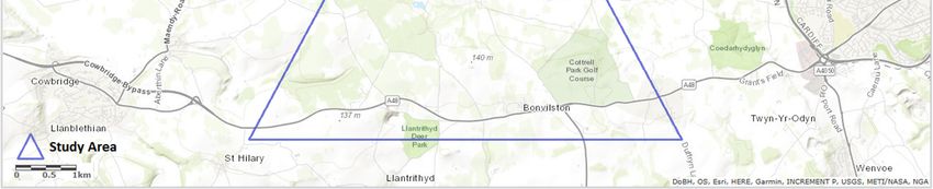
Improving Strategic Transport Encompassing Corridors from M4 Junction 34 to the A48
WelTAG Stage Two: Impacts Assessment Report

2 Policy, Legislation and Background Documents
2.1     Overview
This section provides a summary of the policy and legislative framework and background studies and
documents which provide the context for this study.

2.2     National Policy
One Wales: Connecting the Nation - Wales Transport Strategy (2008)
The Wales Transport Strategy (WTS) published in 2008 sets out the Welsh Government’s aim to improve
transport. The WTS focuses on the role that transport can play in delivering the wider policy agenda of
integrating transport with spatial planning, economic development, education, health, social services, and
environment and tourism, whilst meeting the strategic agenda and the implementation framework of the
(then) Wales Spatial Plan. The vision of the WTS is ‘to promote sustainable transport networks that
safeguard the environment while strengthening our country’s economic and social life’.
The WTS sets out five priorities, which provide additional strategic direction and work towards the long-term
outcomes and maximise the scope for local solutions to transport challenges within a consistent national
framework. The five priorities are:
• Reducing greenhouse gas emissions and other environmental impacts;
• Improving public transport and better integration between modes;
• Improving links and access between key settlements and sites across Wales and strategically important
  all-Wales links;
• Enhancing international connectivity; and
• Increasing safety and security.
The WTS has three key sustainable transport themes and a number of desired outcomes, which underpin
the strategy. The three themes underpinning the strategy are:
• Achieving a more effective and efficient transport system;
• Achieving greater use of the more sustainable and healthy forms of travel; and
• Minimising demand on the transport system.
The WTS noted at the time that Cardiff International Airport has experienced steady growth over the last ten
years, however, Bristol and Liverpool experienced significantly stronger growth than Cardiff International
Airport and serve passengers originating in Wales. It is the first preference for Cardiff International Airport to
improve rail and bus connections; developing a more sustainable approach to air travel. A surface access
strategy is also noted as a key action for Cardiff International Airport.
Active Travel (Wales) Act (2013)
The Active Travel (Wales) Act makes provision for the mapping of active travel routes and related facilities.
The Act was passed by the National Assembly of Wales and also seeks to secure new and enhanced active
travel routes and facilities, improving provision for walkers and cyclists. The purpose of the Act is for local
authorities to continuously improve their facilities and routes for pedestrians and cyclists, through provision of
shelter, resting and/ or storage facilities for example. The Act further requires Welsh Ministers to publish
public annual reports regarding the extent to which walkers and cyclists make active travel journeys in
Wales.

                                                                                                                     2
Improving Strategic Transport Encompassing Corridors from M4 Junction 34 to the A48
WelTAG Stage Two: Impacts Assessment Report

Well-being of Future Generations (Wales) Act (2015)
The Act strives to improve the social, economic, environmental and cultural well-being of Wales. The vision
is ‘in 2050, Wales will be the best place to live, learn, work and do business’. The Act makes the public
bodies listed in the Act consider the longer-term perspective; engage with people and communities and each
other; prevent problems; and to deliver a joined-up approach. The draft goals to represent what the long-
term economic, social and environmental well-being of Wales would look like are:

                                                                                  Communities across
               Wales is prosperous and       Wales uses a fair share of
                                                                                 Wales are safe, cohesive
                     innovative                 natural resources
                                                                                      and resilient

                    People in Wales
               participate in our shared        People in Wales are               Wales is a more equal
                culture, with a thriving            healthier                             nation
                living Welsh language

National Transport Finance Plan (2017 Update)
The National Transport Finance Plan was first published in July 2015. The purpose of the plan being to
provide the timescale for financing schemes, the timescale for delivering schemes, detail the estimated
expenditure, and identify the likely source of financing to enable delivery. The National Transport Finance
Plan 2017 Update provides information on progress since publication and sets out a revised programme for
the next three years and beyond.
The plan includes both revenue and capital initiatives, ranging from specific schemes to others where further
investigatory and development work is required. The schemes which are stated as currently under
construction include (R6) M4 Junction 33 west / A4232 and (R14) Improvements to Five Mile Lane, Vale of
Glamorgan. Other relevant schemes are as shown in Table 1. Notably reference NEW 3 refers to the options
being considered in this Stage Two WelTAG study.

Table 1 National Transport Finance Plan Schemes (December 2017)

   NTS
              Description
 Reference

    R32       Explore, and where practicable, apply measures to improve air quality in Air Quality Management Areas
              (AQMA) which relate to the WG network.

   NEW 3      Five Mile Lane – Explore options from Sycamore Cross to [M4] Junction 34.

    R27g      M4 J32 to J35 Corridor.

    R27h      M4 J35 to J49 Corridor.

    AT1b      Ensure the Active Travel (Wales) Act 2013 is delivered (Integrated Network Maps).

    AT1c      Ensure the Active Travel (Wales) Act 2013 is delivered (Active Travel Schemes).

    AT2       Delivering the actions set out in the Active Travel Action Plan.

    AT3       Work with partners to deliver a programme of improvements to the National Cycle Network and that
              contribute to the objectives of the Active Travel Act.

                                                                                                                      3
Improving Strategic Transport Encompassing Corridors from M4 Junction 34 to the A48
WelTAG Stage Two: Impacts Assessment Report

   NTS
               Description
 Reference

   BCT12       Work with local authorities and bus operators to identify congestion and pinch points on the network that
               impact on bus reliability and punctuality and ensure that solutions are integrated into wider highway
               improvements programme.

      A1       Manage funding for the delivery of two return services a day between Anglesey Airport and Cardiff
               Airport.

      A2       We will continue to work with Cardiff Airport and airlines to improve international connectivity to promote
               Wales as a destination for business and leisure, including taking forward measures to improve surface
               access to the airport.

      IT1      Make grant funding available to local authorities for transport, including schemes that will help to
               improve access to employment sites, road safety schemes and schemes that will deliver the Welsh
               Government’s wider priorities.

      IT3      Review opportunities already identified by others to improve access between and to/ from Enterprise
               Zones and Local Growth Zones, and working with others, identify further opportunities. Develop and
               deliver an improvement programme or support others to do this.

It should be noted that the Wales Spatial Plan will soon be superseded by the new National Development
Framework (NDF). The NDF will set out a 20-year land-use framework for Wales and will:
• Set out where nationally important growth and infrastructure is needed and how the planning system -
  nationally, regionally and locally - can deliver it;
• Provide direction for Strategic and Local Development Plans and support the determination of
  Developments of National Significance;
• Sit alongside Planning Policy Wales, which sets out the Welsh Government’s planning policies and will
  continue to provide the context for land-use planning; and
• Support national economic, transport, environmental, housing, energy and cultural strategies and ensure
  they can be delivered through the planning system.
Whilst the detail of the NDF has not yet been published, the key point of note is that an additional layer of
planning will be added into the system, with Strategic Development Plans (SDP) where appropriate acting a
bridge between the NDF and Local Development Plans (LDP). It is likely that the Cardiff Capital Region and
Swansea Bay City Region will benefit from a SDP, which will support the determination of ‘Developments of
National Significance’. From a Vale of Glamorgan perspective, the Enterprise Zone will potentially be defined
as such a development within any Capital Region SDP. This would provide an added layer of policy support
for improving connectivity to and from the Vale of Glamorgan.

2.3         Local Policy
Vale of Glamorgan Adopted LDP (2013)
The Vale of Glamorgan LDP 2011-2026 was adopted on the 28th June 2017, superseding the previous
adopted Unitary Development Plan (UDP). The LDP will be the basis for decisions on land use planning in
the Vale of Glamorgan and will be used by the Council to guide and manage new development proposals.
The plan has been written mindful of the need to regenerate and support communities and in doing so seeks
to achieve a balance between economic growth, social cohesion and environmental impact.
Pendoylan, Bonvilston, St Nicholas and Peterston-super-Ely are identified as minor rural settlements with the
LDP Settlement Hierarchy. The LDP refers to the minor rural settlements as functionally linked, emphasising
the importance of safeguarding facilities as well as facilitating new development opportunities. The LDP
Strategy comprises four key elements ‘to promote development opportunities in Barry and the South East

                                                                                                                             4
Improving Strategic Transport Encompassing Corridors from M4 Junction 34 to the A48
WelTAG Stage Two: Impacts Assessment Report
Zone. The St Athan area to be a key development opportunity and Cardiff Airport a focus for transport and
employment investment. Other sustainable settlements to accommodate further housing and associated
development.’
A summary the key strategic policies relevant to the study have been included within Table 2, with an
applicable section of the Vale of Glamorgan LDP proposals map (2017) relevant to the study area shown in
Appendix A.
Table 2 Key Strategic Policies Relevant to the Study Area
Policy Description
Policy SP1 Delivering the Strategy (including 4. Promoting Sustainable Transport).
Policy SP2 Strategic Sites – Land is allocated for development at strategic sites including mixed use at St
Athan and employment uses at land adjacent to the airport and Port Road, Rhoose, as part of the
St Athan – Cardiff Airport Enterprise Zone.
Policy SP5 Employment Requirements – To ensure the continued prosperity of the Vale of Glamorgan and
promote growth in the capital region.
Policy SP7 Transportation – Sustainable transport improvements that serve the economic, social and
environmental needs of the Vale of Glamorgan and promote the objectives of the South East
Wales Regional Transport Plan (RTP) and the Local Transport Plan (LTP) will be favoured. Priority
will be given to schemes that improve highway safety and accessibility, public transport, walking
and cycling. Surface and public transport access to Cardiff Airport is highlighted as in need of
significant improvements if the potential of the airport is to be realised.
This will include bus priority measures to the airport, a new Northern Access Road, with the latter
incorporating walking and cycling infrastructure. The provision of a strategic highway network is
further described as vital to the efficient movement of people and goods throughout the Vale of
Glamorgan, with particular emphasis on providing improvements in access to Barry, Cardiff Airport
and St Athan from the M4.
Policy SP10 Built and Natural Environment – Development proposals must preserve and where appropriate
enhance the rich and diverse built and natural environment and heritage of the Vale of Glamorgan
including:
• The architectural and/ or historic qualities of buildings or conservation areas, including locally
listed buildings;
• Historic landscapes, parks and gardens;
• Special Landscape Areas (SLA);
• The Glamorgan Heritage coast;
• Sites designated for their local, national and European nature conservation importance; and
• Important archaeological and geological features.
Policy MD7 Environmental Protection – Development proposals will be required to demonstrate they will not
result in an unacceptable impact on people, residential amenity, property and/ or the natural
environment.
Policy MD8 Historic Environment – Development proposals must protect the qualities of the built and historic
environment of the Vale of Glamorgan.
Policy MD9 Promoting Biodiversity – New development proposals will be required to conserve and where
appropriate enhance biodiversity interests unless certain conditions can be demonstrated.
5Improving Strategic Transport Encompassing Corridors from M4 Junction 34 to the A48
WelTAG Stage Two: Impacts Assessment Report
Policy Description
Policy MG9 Employment Allocations – including at Land to the South of Junction 34 M4 Hensol; Land adjacent
to Cardiff Airport and Port Road, Rhoose; and Aerospace Business Park, St Athan Rhoose.
Policy MG10 St Athan – Cardiff Airport Enterprise Zone – including provision of sustainable transport
infrastructure.
Policy MG11 Land to the south of Junction 34 M4, Hensol – Land is allocated to the south of Junction 34 M4
(Hensol) for employment purposes to meet local need.
Policy MG16 Transport Proposals – Land for the following transportation schemes (relevant to the study) is
allocated:
• Walking and cycling: A4050 Port Road to Cardiff Airport;
• Rail: Modernisation of the Valley Lines; and
• Highways: Northern Access Road (St Athan Enterprise Zone); Improvements to the A4226
between Waycock Cross, Barry and Sycamore Cross, A48 (Five Mile Lane); North of A48,
Bonvilston Road Improvements.
Policy MG17 Special Landscape Areas – have been designated to protect areas of the Vale of Glamorgan that
are considered to be important for their geological, natural, visual, historic or cultural significance.
The designation of SLAs is not intended to prevent development but to ensure that where
development is acceptable, careful consideration is given to the design elements off the proposal
such as siting, orientation, layout and landscaping, to ensure that the special qualities and
characteristics for which the SLAs have been designated are protected.
Policy MG19 Sites and Species of European Importance – Development proposals likely to have a significant
effect on a European site will only be permitted under certain conditions.
Policy MG20 Nationally Protected Sites and Species – Development likely to have an adverse effect either
directly or indirectly on the conservation value of a Site of Special Scientific Interest (SSSI) will
only be permitted under certain conditions.
Policy MG21 Sites of Importance for Nature Conservation, Regionally Important Geological and
Geomorphological Sites and Priority Habitats – Development proposals likely to have an adverse
impact on sites of importance for nature conservation or priority habitats and species will only be
permitted under certain conditions.
Policy MG22 Development in Minerals Safeguarding Areas – Known mineral resources of sandstone, sand and
gravel and limestone are safeguarded. New development will only be permitted in any area of
known mineral resource under certain conditions.
Vale of Glamorgan LTP (2015)
The Vale of Glamorgan LTP has been established to recognise the diverse economic and social geography,
and overlapping labour and housing markets that exist throughout the Capital Region (encompassing Cardiff,
Blaenau Gwent, Bridgend, Caerphilly, Merthyr Tydfil, Monmouthshire, Newport, Rhondda Cynon Taf,
Torfaen and the Vale of Glamorgan).
Whilst acknowledging the requirement for a collaborative approach for the future development of the Capital
Region, the LTP seeks to identify the sustainable transport measures required to ensure Vale of Glamorgan
Council adheres to current requirements and good practice, to allow for a sustainable transport environment
for the period 2015 to 2020, as well as looking forward to 2030.
The plan therefore seeks to secure better conditions for pedestrians, cyclists and public transport users and
to encourage a modal shift away from the single occupancy car. The LTP also ‘seeks to tackle traffic
6Improving Strategic Transport Encompassing Corridors from M4 Junction 34 to the A48
WelTAG Stage Two: Impacts Assessment Report
congestion by securing improvements to the strategic highway corridors for commuters who may need to
travel by car’. The plan highlights actions required including:
• In partnership with bus operators, negotiate expansion of current bus services, linking to key settlements
and interchanges.
• Encourage use of community transport provision to sustain and entice bus operators/ community
transport providers to take over once grown to acceptable sustainable level of patronage.
• To deliver existing safe routes in communities’ schemes identified by schools and the public and
encourage more schemes to come forward for consideration and implementation.
• In partnership with bus operators, negotiate expansion of current services, linking routes where there
needs to be interchange and ensuring timings of connections are acceptable. Encourage use of
integrated ticketing for services. Increase Community Transport to cater for demand.
• Deliver highway/ junction improvement schemes at key locations.
• Deliver bus infrastructure improvement schemes/ corridors.
• Provide Park & Ride/ Park & Share.
Bridgend LDP 2006-2021 (2013)
The adopted Bridgend LDP sets out its objectives for the development and use of land in Bridgend County
Borough. The LDP sets out a plan to deliver sustainable development and guide growth and change, while
protecting local diversity, character and sensitive environments. Objective 1 is to produce high quality
sustainable places including supporting integrated transport solutions and measures that will encourage
modal shift to more sustainable forms of transport for people and freight.
Rhondda Cynon Taf LDP 2006-2021 (2011)
The adopted LDP provides a policy framework that integrates and balances the social, economic and
environmental issues in order to meet the needs of those people living, working and visiting Rhondda Cynon
Taf. Key policies relevant to this study include the following.
Policy CS 2 Policy CS 8 Policy SSA 2
•Development in the South: 8) •Transportation: b1) The •Park and Ride/ Park and Share
Promoting and enhancing implementation of a strategic Provision: 5) Pontyclun Railway
transport infrastructure transport corridor Station.
services to support growth and management system in the
investment. following strategic corridor
areas including the A4119/
A473 Corridor.
Key developments relevant to this study include the following:
• A major business park is proposed for B1 office development fronting the A4119 at Mwyndy Cross with a
grade-separated junction.
• A residential development of 400 dwellings adjoining the existing residential area, served from the
existing spine road roundabouts, new primary school and local centre at Cefn-yr-Hendy.
City of Cardiff Council
The following documents have also been noted:
• Cardiff LTP (2015)
• Cardiff LDP 2006 – 2026 (adopted 2016)
7Improving Strategic Transport Encompassing Corridors from M4 Junction 34 to the A48
WelTAG Stage Two: Impacts Assessment Report
2.4 Background Documents
Highway Impact Assessment, Deposit LDP Background Paper (2013)
Capita Symonds was commissioned by Vale of Glamorgan Council to undertake a capacity assessment of
the impact of possible future LDP residential development sites on the strategic highway network. This forms
part of the evidence base for the deposit LDP.
Table 3 presents the link and junction capacity assessment results within the appraisal area (based on Ratio
of Flow to Capacity (RFC) / degree of saturation) for the base year and the future year with the LDP
proposals having been implemented.
The table shows that one junction within the appraisal area (Sycamore Cross) is forecast to be over capacity
in the future 2026 year with or without pedestrians. In 2012, the table shows that the junction is over capacity
with pedestrians, but within capacity without pedestrians. Junction improvements have been made to the
Sycamore Cross junction since the report was published. Sycamore Cross was previously a priority junction,
however it is now a signalised junction with turning lanes and formal pedestrian crossing facilities.
Table 3 Junction Capacity Assessment Results
Link / Junction
2012 AM 2012 PM 2026 AM 2026 PM
Name
A48/Five Mile
Over Capacity with Over Capacity with
Lane/Road to Over Capacity with Over Capacity with
or without or without
Pendoylan Pedestrians Pedestrians
Pedestrians Pedestrians
(Sycamore Cross)
A48 (nr the Old Post
Within Capacity Within Capacity Within Capacity Within Capacity
Public House) EB
A48 (nr the Old Post
Within Capacity Within Capacity Within Capacity Within Capacity
Public House) WB
A48 (nr St Nicholas)
Within Capacity Within Capacity Within Capacity Within Capacity
EB
A48 (nr St Nicholas)
Within Capacity Within Capacity Within Capacity Within Capacity
WB
Sustainable Transport Assessment, Deposit LDP Background Paper (2013)
The Sustainable Transport Assessment forms part of a series of topic papers prepared by Vale of
Glamorgan Council as part of the evidence base used to inform the production of policies and site allocations
for the Deposit LDP. This assessment seeks to identify the sustainable transport measures required to
create and ensure a sustainable transport environment in the Vale of Glamorgan.
Vale of Glamorgan Council is committed to reducing the environment impact of its activities and as such
seeks to provide transport infrastructure and transport services to assist the public to choose sustainable
travel modes for all journeys where possible. This includes for all new developments to include off-road
shared use walking/ cycling routes where possible and cycle signs on main roads where off-road facilities
are not practical.
Walking and Cycling
A number of walking and cycling schemes have been funded/ proposed in the appraisal area since the RTP
Capital programme implementation began in April 2010. This includes NCN88 (£311,000) – Match funding
European Creative Rural Communities Grant over a 3-year programme to deliver walking and cycling routes
throughout the rural Vale, including around Cardiff Airport.
8Improving Strategic Transport Encompassing Corridors from M4 Junction 34 to the A48
WelTAG Stage Two: Impacts Assessment Report
Bus
The report notes that at the time of writing within the last five years, funding for bus services had declined.
There had been a reduction of £8m of Grant throughout Wales despite the agreed objectives of increased
patronage and improved services still standing. The objectives for bus services are as follows:
To provide and promote safe, attractive and accessible bus and community
transport links to key regional centres and destinations.
To maximise opportunities to maintain and stimulate passenger growth.
To improve the quality and efficiency of bus and community transport services.
To address exclusion from the core network through the most appropriate
mode, including the use of flexible bus services and community transport.
To encourage partnership working in information provision, ticketing and
service provision.
To ensure buses and community transport play their full role within the Sewta
Metro Plus integrated transport network.
To provide a foundation for bus infrastructure enhancement programmes.
The LDP supports Bus-Based Park & Ride initiatives as a transport planning tool that can be used to
encourage car users to switch to public transport. Locations identified as suitable for developing Park and
Ride sites include M4 Corridor Junction 34/ Hensol (of which it is noted that no land has so far been
identified). It is noted that bus based Park and Ride sites need to be large enough to significantly reduce car
traffic on the target corridors and that for regional sites, parking for a minimum of 500 cars will be required
along with bus priority measures along the line of route. Essential factors to address in the design and
implementation of Park and Ride sites include:
• Clear and conspicuous signposting;
• Ease of access to the site;
• Comparative Bus-Based Park & Ride and central area parking tariffs;
• The quality, frequency and reliability of the transit service;
• Journey time advantages over the car; and
• Site facilities, such as shelter, passenger information and security measures.
Cardiff City Region Transport Implementation Plan (2010)
The City Region Transport Implementation Plan prioritised measures for funding and delivery, as part of
Cardiff Council’s sustainable travel centre initiative.
The plan notes how an informal Park and Share site is already located at M4 Junction 34, illustrating a latent
demand for such a facility. The creation of a formal Park and Share site could accommodate existing
demand and encourage other Park & Share user trips. The site may be an opportunity to make use of the
nearby mainline railway to develop the site as a multi-modal transport hub. The plan suggests an initial 250
spaces to be constructed with potential for future extension.
9Improving Strategic Transport Encompassing Corridors from M4 Junction 34 to the A48
WelTAG Stage Two: Impacts Assessment Report
International Connectivity through Welsh Ports and Airports (July 2012) – National
Assembly Enterprise and Business Committee
The International Connectivity through Welsh Ports and Airports report provides recommendations for the
Welsh Government, whilst acknowledging the need to engage with other stakeholders including the UK
Government where appropriate. The aim of this inquiry by the National Assembly’s Enterprise and Business
Committee was to explore:
• How important major Welsh ports and airports are to the economy of their own regions and to Wales as a
whole;
• What factors limit realisation of the potential offered by major Welsh ports and airports; what opportunities
are available to develop this potential, and how these can be realised; and
• How effectively Welsh Government policies support the development of major Welsh ports and airports.
The report notes that around 73% of passengers travel to Cardiff Airport via car whilst the remainder use
public transport, in particular buses3. Recommendations included in the report are as follows:
• Recommendation 5: The Welsh Government should introduce an improved, dedicated express bus
service between Cardiff Airport and the city centre, and explore options for funding that service with
partners and other key stakeholders.
• Recommendation 8: The Welsh Government should integrate connectivity to Welsh Airports with
transport and infrastructure policy for Wales as a whole, and seek to negotiate the provision of better
cross-border transport links and prospective electrification of rail services such as for Swansea and the
Valleys.
Sewta Rail Strategy 2013 (Jacobs)
The Sewta Rail Strategy is a report prepared by Jacobs which set out the investment which the combined
local authorities in South East Wales believed are needed to ensure a robust and efficient rail network over
the next 20 years. The strategy is planned to accommodate passengers in comfort and encourage growth of
both rail passengers and freight in an environmentally sustainable form.
The Sewta vision for improving the rail network seeks to provide a more attractive transport option with a
minimum frequency of half hourly services made up of higher capacity electric trains. The Cardiff Area
Signalling Renewal project offers the scope to secure additional capacity at the core of the Valley Lines
network, through an enhancement option which will require continued Welsh Government funding support.
Rail demand on the Vale of Glamorgan Line (as indicated in Figure 1), interconnecting Valley Lines and
elsewhere in South East Wales has been growing at a rate significantly above GDP. In order to avoid
overcrowding at this high growth rate, significant short-term investment in additional rolling stock is needed
as well as medium term rolling stock renewal through Valley Lines electrification. The rail strategy is based
on provisions such as providing longer trains to accommodate passenger growth and improving the
frequency of existing passenger services.
Investment opportunities identified for the Vale of Glamorgan Line:
• Additional rolling stock required to strengthen peak train to address passenger growth and to avoid
overcrowding; and
• Station enhancements including improved station facilities, information, security and access.
3
Department for Transport, Record of Proceedings paragraph 138, 8 March 2012 (am)
10Improving Strategic Transport Encompassing Corridors from M4 Junction 34 to the A48
WelTAG Stage Two: Impacts Assessment Report
Figure 1 Demand/ Capacity during the AM Peak (Vale of Glamorgan Line)
Cardiff Capital Region Metro Study (2013)
The Metro Study sets out a strategic regional plan for developing the Metro, which is:
‘A turn up and go integrated transport network that will connect over 70% of the population of the Cardiff City
Region, developed in a way that enables and/ or enhances developments at strategic sites, maximises
economic benefits & facilitates regeneration’.
The study identifies a number of relevant existing transport problems and key trends:
• Limited integration between rail and bus services;
• Problems many people in the region encounter in accessing work, education and healthcare because of
lack of available, affordable transport;
• Limited public transport access to some of the region’s major hospitals, schools and other public services;
and
• The Vale of Glamorgan rail line generally has poor frequencies (with one train an hour).
The Metro’s extent includes routes east of Cardiff including to Cardiff Airport and Pontyclun, towards
Maesteg. The study notes the need for invested improved connectivity for Cardiff Airport, stating ‘There is
much evidence that demonstrates a link between the economic performance of a region and its level of
international connectivity. Whilst better access to Heathrow and its extensive range of long haul flights is
essential to the economy of South East Wales, so is the need to provide access to international markets
from Cardiff Airport. Such connectivity will support the case for inward investment to the region. Whilst
Cardiff Airport has a limited natural catchment area, it can be extended with the appropriate investment in
transport infrastructure. This may help the airport secure untapped demand for services to destinations in the
Middle East, some European cities and locations in the US & Canada (predominantly served via Heathrow
and Bristol’.
Cardiff Airport is noted to be a pivotal regional asset whose performance can be enhanced by increasing its
catchment area by public transport. From a Metro perspective this is said to require a new or upgraded
airport station - either on the current Vale of Glamorgan line or at the current airport site via a new spur. New
services from across the region and from out of the region will be able to access the airport either directly or
via a change at Cardiff central. In line with the National Transport Plan 2010, half hourly services would then
be introduced on the Vale of Glamorgan line to facilitate access to airport. M4 Junction 34 (M4 Junction 32-
34) is referred to as an area experiencing congestion and as an existing transport problem that is in need of
addressing. An overview of the Metro priorities is shown in Figure 2.
11Improving Strategic Transport Encompassing Corridors from M4 Junction 34 to the A48
WelTAG Stage Two: Impacts Assessment Report
Figure 2 Metro Priorities4
2.5 Committed Developments
Land South of M4 Junction 34, Hensol
In 2011, Renishaw plc purchased the former Bosch site and surrounding land to the south of M4 Junction 34.
In June 2016, Vale of Glamorgan Council approved plans for ‘development comprising class B1, B2, B8
uses; a hotel/residential training centre (class C1/ C2); and ancillary uses within class A1, A2, A3; associated
engineering and ground modelling works and infrastructure, car parking, drainage and access for all uses;
provision of infrastructure (including energy centre(s)); landscaping and all ancillary enabling works’. The
provision of a work bus service through the day and night is noted within the Travel Plan submitted as part of
the planning application package.
Land at Sycamore Cross, Pendoylan Lane and North of A48, Bonvilston
Planning permission was granted on 2nd February 2017 for a ‘development of 120 homes including
affordable homes, new vehicle, pedestrian and cycle access, improvement works to Pendoylan Lane,
regrading of site, drainage, landscape works, provision of public open space, demolition of existing modern
timber stables and all associated works’. It is proposed that the existing road on Pendoylan Lane will be
remodelled to provide a suitable vehicle access to the site, along with pedestrian and cyclist connection on a
2.5m wide shared surface, connecting to A48. Cycle improvements will be created along the A48 between
Culverhouse Cross and Bridgend. It is noted that all new transport infrastructure should be well lit and have
real time information.
Land Adjacent to A4226, Five Mile Lane
A ‘proposal for on-line improvements to the existing A4226 between Waycock Cross Roundabout in Barry
and the lay-by to the north of the Welsh Hawking Centre and an off line new road provision to the east of the
existing A4226 which will reconnect with the existing A4226 just to the south of Blackland Farm’ was
4
Cardiff Capital Region Metro Study (2013)
12Improving Strategic Transport Encompassing Corridors from M4 Junction 34 to the A48
WelTAG Stage Two: Impacts Assessment Report
approved on 16 December 2016 and are now under construction. Works consist of constructing a new and
upgraded single lane carriageway (7.3m wide with a 1m wide hard strip) making the total carriageway 9.3m
wide, except for the carriageway section approaching Waycock Cross junction which will be 7.3m wide due
to the absence of hard strips. A proposed cycleway/ footpath will be located on the west side of on-line road
comprising a 2.5m wide verge. Three new junctions will be constructed along the route including two priority
T-junctions and one staggered junction all of which will have ghost islands.
At the Sycamore Cross junction, the westbound carriageway of the A48 will be widened to provide a
dedicated lane for turning left onto Five Mile Lane. Road markings will be amended to enable two lanes of
traffic to therefore travel westbound through the existing junction. For eastbound traffic, there will be two
lanes of traffic provided through the junction on the A48 from Bonvilston, heading east towards Culverhouse
Cross. The existing bus lane will be re-aligned further towards the north side of the junction in order to
provide sufficient lane width for traffic on the A48.
Land to the East of Mink Hollow (St Nicholas)
Planning was approved for a proposed residential development for 17 dwellings and associated highway and
ancillary works, in November 2016. A new ghost island junction access arrangement will be constructed to
serve the proposed 20 dwellings, as well as an additional 100 dwellings situated to the west of the site. A
right-turn lane with a width of 3m and through lanes with a width of 3.55m will be created.
Land to the East of St Nicholas
A development of 100 houses and associated open space vehicular and pedestrian access, landscaping and
infrastructure, including the demolition of ‘Emmaville’ was approved by the Vale of Glamorgan in December
2016. The development will be accessed via a new priority T-junction with the A48, to be located through the
land currently occupied by ‘Emmaville’. The house will be removed to allow for the construction of the new
access road. The access road will be 5.5m wide and will also provide 2m wide footways on both sides of the
highway.
Improvements will be made to the existing speed limit change gateway feature will include extending the red
surface treatment across the whole highway as well as providing white lined channels on both edges to
introduce a visual narrowing effect, thus slowing westbound traffic. This will be reinforced with ‘dragon’s
teeth’ road markings on the eastern side of the feature to ensure drivers are aware they are entering a
village and the speed limit changes to 30mph. Eastbound traffic will have to negotiate a change in road
alignment that will be introduced by the ghost island site access junction.
Land to the North of Junction 33 (Creigiau)
A planning application for a comprehensive development of ‘Land to the North of Junction 33 of the M4’ was
approved in September 2017. The proposal is to create a new community containing: a range of new homes,
including houses, apartments and some sheltered accommodation for the elderly (Use Classes C2 and C3),
a Park and Ride facility and transport interchange or hub community facilities including a new primary school
and community centre (Use Class D1), a local centre including shops (Use Class A1), financial and
professional (Use Class A2), food and drink (Use Class A3) and a clinic or surgery (Use Class D1), new
offices, workshops and research and development facilities (Use Classes B1 with Ancillary B2 and B8), a
network of open spaces including parkland, footpaths, sports pitches and areas for informal recreation new
activities and requiring, site preparation, the installation or improvement of services and infrastructure, the
creation of drainage channels, improvements/works to the highway network and other ancillary works and
activities.
The proposed development includes 1,500 new homes and a Park and Ride facility with a maximum of 1,000
spaces. The development is designed to accommodate the aspirational Mass Rapid Transport proposal
currently being investigated and included in the Cardiff Council LDP.
13Improving Strategic Transport Encompassing Corridors from M4 Junction 34 to the A48
WelTAG Stage Two: Impacts Assessment Report
3 Baseline Information
3.1 Introduction
This section presents a summary of the baseline context of the appraisal area encompassing:
Local Appraisal Area
Environmental and Land-use Characteristics
Access to Employment
Access to Services and Recreation
Access to Culrural Facilities
Walking and Cycling
Rail and Bus
Highway Network
3.2 Local Appraisal Area and Vale of Glamorgan Context
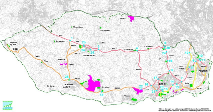
The study area is as shown in Figure 3.
Figure 3 Study Area
14Improving Strategic Transport Encompassing Corridors from M4 Junction 34 to the A48
WelTAG Stage Two: Impacts Assessment Report
The Vale of Glamorgan administrative area is situated to the west of Cardiff predominantly south of the M4
corridor and is extensively rural with a pattern of small settlements. The Vale of Glamorgan has a population
of approximately 128,500 (2016 Census) which has increased by circa 5% since 2001, with population
statistics presented in Table 4. The neighbouring local authorities are Bridgend County Borough Council to
the west, Cardiff Council to the east and Rhondda Cynon Taff County Borough Council to the north, with the
local authority boundary including the M4 Junction 34.
Table 4 Usual Resident Population Statistics5
Population Change
Location 2011 Population
(since 2001)
Appraisal Area 2,289 +2%
Vale of Glamorgan 126,336 +5%
RCT 234,410 +1%
Bridgend 139,178 +8%
Cardiff 346,090 +13%
The deposit LDP (2013) recognises the M4 and A48 as key strategic road links within the county, connecting
with to the wider south-east region and beyond. The Pendoylan corridor connects to the strategic network via
M4 Junction 34 to the north and to the A48, east of Bonvilston, to the south. Redway Road/ unnamed road
runs parallel to and also connects to the Pendoylan corridor, to the west. The carriageway connects to the
Pendoylan corridor through Pendoylan at Clawdd-côch, to the north, and the A48 west of Bonvilston to the
south.
The appraisal area is not connected to the region via rail directly, however Pontyclun station (South Wales
Mainline) is located within proximity of the appraisal area, providing services to Maesteg, Bridgend and
Cardiff Central (approximately 5.5km north-west of Pendoylan). In addition, Cardiff Airport is located in
proximity to Rhoose (approximately 11km south of Pendoylan).
Bonvilston, Pendoylan and Peterston-super-Ely have been identified as minor rural settlements in the LDP
Settlement Hierarchy6. These settlements are noted to contribute towards the special character of the rural
Vale and also play an important role in underpinning sustainable rural communities.
The age profile of the population in the appraisal area comprises a population aged 0-15 of 19%, working
age 61% and 20% of retirement age which is higher for children and retired people, and lower for working
age adults than that for the Vale of Glamorgan overall. This is shown in Figure 4.
The Vale of Glamorgan exhibits considerable socio-economic diversity containing some of the most affluent
and the most deprived communities in Wales in respect of employment, income, education, health and
community safety. The Welsh Index of Multiple Deprivation (WIMD) 20147, shows that of the 79 lower super
output areas (LSOA) in the Vale of Glamorgan, 5% of which are contained with the most deprived 10%
LSOA in Wales8.
5
Census (2011, 2001)
6
Vale of Glamorgan LDP 2011-2026 – Written Statement – June 2017
7
Welsh Government – Welsh Index of Multiple Deprivation 2014 http://gov.wales/docs/statistics/2015/150812-wimd-
2014-summary-revised-en.pdf
8
Welsh Government – Welsh Index of Multiple Deprivation 2014 Local Authority Analysis -
https://statswales.gov.wales/Catalogue/Community-Safety-and-Social-Inclusion/Welsh-Index-of-Multiple-
Deprivation/WIMD-2014/wimd2014localauthorityanalysis
15Improving Strategic Transport Encompassing Corridors from M4 Junction 34 to the A48
WelTAG Stage Two: Impacts Assessment Report
Figure 4 Age Profiles 2011 Census
70
64%
61%
60
50
40
30
19% 20% 18%
20 18%
10
0
Aged 0-15 Working Age Retirement Age
Study Area (%) VoG (%)
The appraisal area contains some of the least deprived areas. The average gross weekly full time pay in the
Vale of Glamorgan was £534.60 in 2014, which was almost £50 a week more than the figure for Wales9.
Whilst at local authority level, the Vale of Glamorgan points to a higher income than other parts of Wales, at
lower geographies it is evident that there is a great deal of variation. Four LSOAs within the local authority
have incomes 60% below the GB median income.10
A summary of employment statistics for the appraisal area has been included as Table 5 against regional
and national statistics. Census data (2011) shows that there was a higher percentage of those employed
within the appraisal area and also the Vale of Glamorgan as a whole (figures at 63 and 62%) compared with
58% for SE Wales and Wales as a whole. There is a significantly higher population of retired people within
the appraisal area compared to the Vale of Glamorgan, South East Wales and Wales as a whole.
Table 5 Employment Statistics Census 2011
The Vale of
Economic Activity Appraisal Area South East Wales Wales
Glamorgan
Employed 63% 62% 58% 58%
Unemployed 2% 4% 5% 4%
Retired 21% 16% 15% 16%
Student 7% 7% 10% 9%
Other 8% 10% 13% 12%
*Figures rounded
9
Annual Survey of Hours and Earnings 2014
10
Vale of Glamorgan LSB Tackling Poverty Report - https://statswales.gov.wales/Catalogue/Community-Safety-and-
Social-Inclusion/Welsh-Index-of-Multiple-Deprivation/WIMD-2014/wimd2014localauthorityanalysis
16You can also read