IOWA MONTHLY WEATHER SUMMARY - MAY 2021
←
→
Page content transcription
If your browser does not render page correctly, please read the page content below
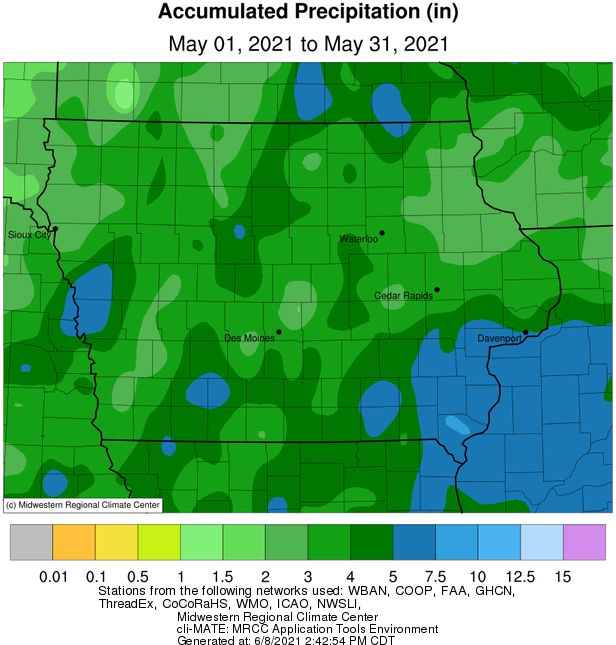
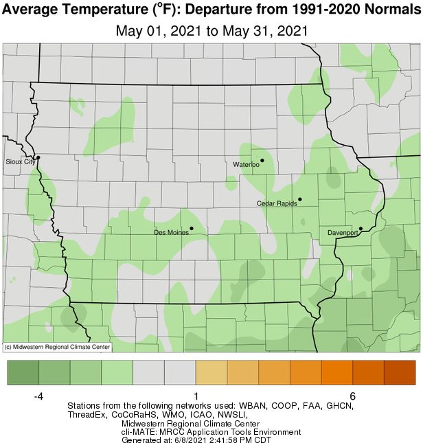
IOWA MONTHLY WEATHER SUMMARY – MAY 2021

General Summary: Temperatures averaged 59.0 degrees or 0.9 degree below normal while precipitation totaled 3.71
inches or 1.13 inches below normal. May 2021 ties 1957 and 2013 as the 53rd coldest; it was also the 64th driest May
in 149 years of statewide records. A colder May occurred last year while a drier May last occurred in 2014.

Temperatures: Cooler than average temperatures were reported across eastern and southern Iowa with near-normal
conditions across the rest of the state. On average, statewide temperatures were only slightly cooler than normal.

A notable late-season freeze event occurred overnight into Saturday the 29th with near or below freezing
temperatures at several northern and eastern Iowa National Weather Service co-op stations, leading to sporadic crop
damage; the statewide average low was 37 degrees, 13 degrees below normal.

May’s statewide average maximum temperature was 69.3 degrees, 1.5 degrees below normal while the average
minimum temperature was 48.7 degrees, 0.6 degree above normal. Spencer Municipal Airport (Clay County)
reported the month’s high temperature of 97 degrees on the 1st, 31 degrees above average. Estherville Municipal
Airport (Emmet County) reported the week’s low temperature of 26 degrees on the 11th, 18 degrees below normal.

Heating Degree Days: Home heating requirements, as estimated by heating degree day totals, averaged 12% less
than last May and 8% more than normal. Heating degree day totals are running 1% less than last year at this time
and 2% less than normal.

Precipitation: Most of Iowa’s National Weather Service co-op stations reported below-average totals during the
month; pockets of two to three inch departures were reported across the state. Extreme southeastern Iowa was
the only section of the state to report above-average totals, on the order of one to three inches.

A low pressure center pushed into northern Iowa overnight into the 3rd, firing off a few stronger thunderstorms
along the attendant cold front in western Iowa. Showers and thunderstorms filled in across Iowa’s western half in
the early morning hours before dissipating towards sunrise. As the front moved into eastern Iowa, rain reformed
with locally heavier amounts from thunderstorms in southeastern Iowa. Except for extreme northwest Iowa,
measurable rain fell statewide with the highest totals found in a band from west-central to northeastern Iowa and
over the southeastern corner; generally above 0.50 inch with lesser totals in between. Several stations in Harrison
and Monona counties measured above two inches; a rain gauge near Cresco (Winneshiek County) collected 3.00
inches. Cloud cover began to increase through the day on the 5th as another disturbance brought light rain showers
in northern and western sections of the state, though widespread totals were under a few tenths of an inch. The
low pressure center pushed out of eastern Iowa early on the 6th with winds shifting to a northerly direction from
south-westerly and then to a pure easterly flow as a weak cold front dropped through Iowa early on the 7th. Clouds
increased as a strong low pressure system propagated towards western Iowa into the 8th with rain showers and
some thunderstorms moving over the state’s northern half. As the low center approached northern Missouri, a
shield of moderate to heavy rain filled in across southern Iowa through the overnight hours into the 9th with 24-
hour totals highest across southern sections of the state. Nearly 70 stations reported an inch or more with
Washington (Washington County) measuring 2.00 inches while Columbia (Marion County) observed 2.60 inches;
the statewide average rainfall was 0.88 inch, with only a handful of northeastern Iowa stations reporting no rain.

Rain showers developed over eastern Iowa early on the 10th with very light totals where rain fell. As the pattern
cleared and a dome of high pressure took hold over the Midwest, skies cleared with light northerly winds overnight
into the morning of the 11th. Clouds increased through early in the morning of the 14th in advance a low pressure
center over the Dakotas, producing showers in western Iowa during late morning. The area of rainfall pushed into
central Iowa and persisted across eastern Iowa into the evening. Scattered showers reformed over Iowa’s eastern
half in to the 15th with totals reported at 7:00 am highest from central Iowa into the southeast corner; a rain gauge
in Prole (Warren County) measured 1.16 inches. General amounts where showers persisted ranged from 0.25 inch
to 0.75 inch; the statewide average was 0.21 inch. A secondary disturbance moving through northern Iowa along
with warm daytime highs forced showers and thunderstorms to fire during the afternoon and evening hours. Some
storms were strong with heavy downpours. The line of thunderstorms dissipated into the evening hours with foggy
conditions observed overnight, given higher dew points and low temperatures in the 50s. Rain totals reported on
Sunday (16th) morning were mostly a few tenths of an inch, though several stations reported over 0.50 inch;
Keokuk Lock and Dam (Lee County) measured 1.01 inches while Grundy Center (Grundy County) observed 1.40
inches.

Dreary conditions persisted across southern Iowa through the 16th as rain showers propagated west to east. Rain
totals reported at 7:00 am on the 17th were highest south of Interstate 80 with widespread totals above 0.50 inch;
Community Collaborative Rain, Hail and Snow (CoCoRaHS) gauges in Creston (Union County) and College Springs
(Page County) measured 1.18 inches. A low pressure center over Missouri streamed showers into eastern Iowa
overnight into the 18th. Rain continued across much of Iowa’s eastern third into the nighttime hours as winds
shifted to a southerly direction. A warm front lifted north over Iowa early on the 19th ahead of another disturbance
that brought a complex of showers in western Iowa. As the day progressed, more showers and a few
thunderstorms moved south to north through Iowa, bringing widespread rainfall to a majority of reporting stations.
Rain totals were generally above a tenth of an inch with pockets of 0.50 inch to 0.75 inch in southwestern and
northwestern Iowa; several rain gauges in Dickinson County reported over an inch with the statewide average
rainfall at 0.28 inch.

With adequate moisture flowing into the Midwest, rain continued over Iowa through Thursday (20th) with a swath
of 0.50 inch to 1.50 inches from the southwest through north-central Iowa. Over 20 stations reported an inch or
more with Boone (Boone County) picking up 2.14 inches. Another system propagating across western Missouri
brought additional rainfall over portions of Iowa through the 22nd before dissipating at sunset. Event totals
reported at 7:00 am on the 23rd were generally light, though southeastern Iowa had pockets of higher amounts
with Salem (Henry County) observing 0.66 inch. Spotty showers popped up across eastern Iowa through the
afternoon and evening hours on the 23rd with generally light totals under a few tenths of an inch; two stations near
Coralville (Johnson County) measured 1.15 inches and 1.28 inches, respectively, from a heavier cell. Additional
showers formed in eastern Iowa over the morning hours of the 24th and persisted for several hours. More showers
moved into northwestern Iowa along the border with South Dakota and Minnesota; five rain gauges in Lyon County
collected from 0.61 inch to 1.15 inches from the heavier showers. Clouds increased west to east as a low pressure
system pushed into southwestern Iowa early on the 27th, streaming additional showers across the region. The
disturbance cleared Iowa’s northeastern corner later in the afternoon. Event rainfall totals observed at 7:00 am on
the 28th showed nearly 50 stations picking up an inch or more with a gauge near Fort Madison (Lee County)
measuring 2.40 inches; the statewide average rainfall was 0.57 inch.

Monthly precipitation totals ranged from 1.95” in Akron (Plymouth County) to 8.53” at a Community Collaborative
Rain, Hail and Snow (CoCoRaHS) network rain gauge near West Point (Lee County).

Spring Summary: Temperatures for the three spring months of March, April and May averaged 50.2 degrees, 1.9
degrees above normal. This spring ties 1902, 1911, 1936 and 2006 as the 29th warmest on record; Spring 2016 was
warmer. Precipitation totaled 8.08 inches or 2.42 inches below normal. This ties 1935 as the 52nd driest May in 149
years of records with a drier spring last occurring in 2000.
Severe Weather: The final month of meteorological spring continued a two-month streak of very little severe activity
with only two reports during May. A disturbance moving through northern Iowa along with warm daytime highs
forced showers and thunderstorms to fire during the afternoon and evening hours of the 10th. Some storms were
strong with heavy downpours; a severe thunderstorm produced large hail, with a diameter of 1.75 inches, in Fayette
(Fayette County). With adequate moisture flowing into the state on the 20th, a discrete thunderstorm spawned a
weak tornado over northwestern Dallas County during the evening with heavy downpours in certain locations; no
damage was reported. On the 25th, a strong cold front pushed into a region atmospheric instability. As the front
advanced into central Iowa, strong and some severe thunderstorms fired in the evening, quickly losing strength as
the sun set; 1.25-inch hail was reported in Des Moines (Polk County).

US Drought Monitor: As of the first week of May, D0-D2 categories covered 78% of the state, the highest extent since
mid-September 2020. The categorical breakdown is as follows: D0 – 42%, D1 – 29%, D2 – 8%. A pattern shift during
into the second week of May brought much needed rainfall statewide with the highest amounts across southern one-
third of Iowa, where about 15% of D0 was removed. Additional rainfall and cooler temperatures held the map status
quo through the end of May. With warmer and drier conditions building in during the first week of June and below
average rainfall over the last seven to 10 days, D1 drought conditions significantly expanded across the northern two-
thirds of Iowa with additional D0 expansion into southern Iowa; only southeastern Iowa was free of abnormally dry
and drought conditions. The current breakdown of D0-D3 conditions is: D0 – 32%, D1 – 47%, D2 – 10%.

Justin Glisan, Ph.D.
State Climatologist of Iowa
Iowa Dept. of Agriculture & Land Stewardship
Wallace State Office Bldg.
Des Moines, IA 50319
Telephone: (515) 281-8981
E-mail: Justin.Glisan@IowaAgriculture.gov
IOWA MONTHLY WEATHER SUMMARY - MAY 2021

                                                          May 2021
                                                 WEATHER BY DISTRICTS
                TEMPERATURE (F)               HEATING DEGREE DAYS                               PRECIPITATION (inches)
                                                                                                               SNOWFALL
                    May 2021           May 2021       Since Jul., 1, 2020    May 2021        Since Jan.1, 2021  May 2021
DISTRICT        Average Departure* Average Departure* Average Departure* Average Departure* Average Departure* Average

Northwest         58.1       -0.7       253        +9        7223        -180       3.09      -1.18       9.02      -1.72        0.0
North Central     58.2       -0.3       250        +2        7246        -218       3.66      -1.22       8.67      -3.84        0.0
Northeast         57.7       -0.7       257        +10       7277         -54       3.09      -1.63       8.13      -4.88        0.0

West Central      58.9       -1.1       231        +18       6682        -138       3.66      -1.06      10.28      -1.44        0.0
Central           59.4       -0.7       220        +9        6735         -70       3.78      -1.18       8.93      -3.87        0.0
East Central      59.0       -1.6       227        +27       6676        +49        3.88      -0.74      10.81      -2.47        0.0

Southwest         60.2       -1.1       200        +17       6259        -3         3.54      -1.74      11.37      -1.34        0.0
South Central     60.5       -0.6       192        +5        6252       +13         3.77      -1.45      11.05      -2.49        0.0
Southeast         59.5       -2.2       214        +39       6274       +136        5.16      +0.04      14.28      +0.18        0.0

STATE             59.0       -0.9         228        +17       6755         -36        3.71      -1.13    10.13       -2.51      0.0
                                            * Departures are computed from 1991-2020 normals.
   The weather data in this report are based upon information collected by the U. S. Dept. of Commerce, NOAA National Weather Service.
You can also read