Location Platform Benchmarking Report: 2021 - HERE ...
←
→
Page content transcription
If your browser does not render page correctly, please read the page content below

Wireless Media

Location Platform Benchmarking Report: 2021
 20 April 2021

                           Report Snapshot
                           This report updates our annual benchmark
                           of global location companies, which
                           compares Google, HERE, Mapbox and
                           TomTom across capabilities like map
                           making and freshness, meeting
                           automotive industry needs, map and data
                           visualization, and the ability to appeal to
                           developers, among others. HERE
                           demonstrates strength and leadership
                           across most attributes, followed by Google
                           and TomTom, then Mapbox.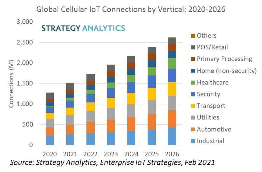
Wireless Media

Contents
1. Executive Summary .................................................................................4

2. Introduction .............................................................................................6
2.1 Defining Location Platforms........................................................................................................ 6
2.2 Map Making & Maintenance Evolution ....................................................................................... 7

3. Pandemic Opportunities and Challenges .............................................8

4. Evolving Location Sector Demands .................................................... 10
4.1 The Automotive Sector .............................................................................................................. 10
4.2 The Mobility and On-Demand Sector........................................................................................ 14
4.3 Enterprise .................................................................................................................................... 16
      4.3.1 Asset Tracking & Fleet Management ......................................................................................... 18
4.4 Mobile Apps and 5G Networks ................................................................................................... 21
      4.4.1 5G Networks ..................................................................................................................................... 22
4.5 Location-Based Advertising & Marketing ................................................................................. 22

5. Location Platform Benchmarking ....................................................... 23
5.1 Benchmarking Update & Result Summary............................................................................... 25
5.2 Benchmarking Category Results ............................................................................................... 27
      5.2.1 Map Making and Map Freshness ................................................................................................. 30
      5.2.2 Automotive Location Services .................................................................................................... 36
      5.2.3 POI and Search................................................................................................................................. 43
      5.2.4 Developer Community .................................................................................................................. 45
      5.2.5 Map and Data Visualization.......................................................................................................... 49
      5.2.6 Openness and flexibility ............................................................................................................... 52
      5.2.7 Vision and Growth Leadership .................................................................................................... 53

6. Strengths and Weaknesses .................................................................. 56

© Strategy Analytics 2021 All Rights Reserved | www.strategyanalytics.com                                                                                     2
Wireless Media

7. Analyst Contacts ................................................................................... 58

Table of Exhibits

Exhibit 1 The Location Based Services Value-Chain ................................................................................................... 6
Exhibit 2 Annual Sales of Navigation Enabled Cars: 2019-2025 ............................................................................12
Exhibit 3 Global Active Ride-Hailing User Growth: 2018-2025 ...............................................................................16
Exhibit 4 Importance of Location Intelligence to Business Performance, By Sector .....................................17
Exhibit 5 Global Cellular IoT Connections: 2020-2026..............................................................................................20
Exhibit 6 Summary of Location Platform Benchmark Scores ................................................................................29
Exhibit 7 Strengths & Weakness Analysis of Major Location Platforms..............................................................56

© Strategy Analytics 2021 All Rights Reserved | www.strategyanalytics.com                                                                            3

Wireless Media

1. Executive Summary
In the 2021 Strategy Analytics’ location-platform benchmarking report HERE is a
leader and co-leader across many of our seven categories, followed closely by
Google and TomTom, and Mapbox in final position. Competition in the location
sector remains intense as both use-cases and the nature of demand evolves.

     •    Strategy Analytics annual benchmarking ranks location platforms,
          Google, HERE, Mapbox and TomTom across the following seven
          categories: Map-making and freshness, automotive, POI search,
          developer community, openness and flexibility, map and data vision,
          and industry vision/ growth.
     •    HERE remains a leader in automotive and industry growth vision. It is
          also a co-leader in openness and scores strongly in other categories,
          like map-making. HERE’s platform approach is beginning to pay
          dividends and is driving non-automotive growth across target sectors,
          e.g. transport and logistics, telecoms, media, and technology, among
          others. Partnerships, its open, multi-platform approach, and tech
          innovation remain key pillars of its growth strategy.
     •    Google maintains leadership in map-making and freshness, place
          search and developer community. The granularity and scale of
          Google’s place search is unrivalled. Its weakness remains a lack of
          openness and flexibility. Its progress in automotive continues –
          adding Ford as a customer while Waymo continues to build its
          autonomous capability. Google has significant resources, tech
          leadership, and a strong consumer and developer brand in location
          services as key strengths.
     •    TomTom is a co-leader in openness and flexibility. TomTom scores
          strongly in map-making and automotive, and has improved its score
          in multiple areas, including POI search, developers and visualization.
          TomTom is a leader in traffic content. TomTom’s focus remains on
          automotive and enterprise and since the last report has announced a
          raft of orders in these domains, including Ford, Stellantis, Huawei,
          Verizon, Precisely, and Uber among others.
     •    Mapbox remains a leader in visualization and a co-leader in openness.
          Mapbox’s reliance on OpenStreetMap (OSM) and probe data enables it

© Strategy Analytics 2021 All Rights Reserved | www.strategyanalytics.com                       4
Wireless Media

          to provide map coverage at scale with low cost. However, community
          mapping lacks scale, consistency, quality assurance and provenance
          to satisfy all needs. Mapbox has made some progress in automotive,
          with BMW a highlight, but has a broad range of customers across
          other sectors, including Snapchat, Strava, dpd, and Grubhub and
          Tableau. Its joint venture with Softbank in Japan creates further
          growth opportunities to support advanced location services.

© Strategy Analytics 2021 All Rights Reserved | www.strategyanalytics.com                   5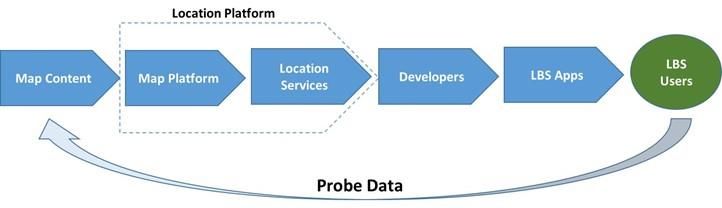
Wireless Media

2. Introduction
2.1 Defining Location Platforms
Strategy Analytics defines a location platform as a company which provides
customers with access to a range of location services which includes digital map
tiles, location content geocoding (converting street names into coordinates and
vice-versa), traffic-optimized routing, local businesses or points of interest (POIs)
search, traffic flow and traffic incident information, and more. Location
platforms enable enterprises and long-tail developers to integrate these
horizontal location services into their own apps and services, so developers need
not invest their own resources in building and maintaining their own maps and
common location service capabilities, Exhibit 1.

                  Exhibit 1 The Location Based Services Value-Chain

Location-based applications and location services are usually underpinned by a
map and supported by geolocation information provided either automatically
via positioning technology like GPS, cell tower/ Wi-Fi signal triangulation, or
manually (e.g. postcode input).

Location platforms also provide tools for businesses, organizations and
developers to customize these location services to their needs. For example,
from modifying the style of the map tiles or emphasizing specific details such as
railway lines or public transport routes through to fully customized integration of
location services into their own apps.

© Strategy Analytics 2021 All Rights Reserved | www.strategyanalytics.com                            6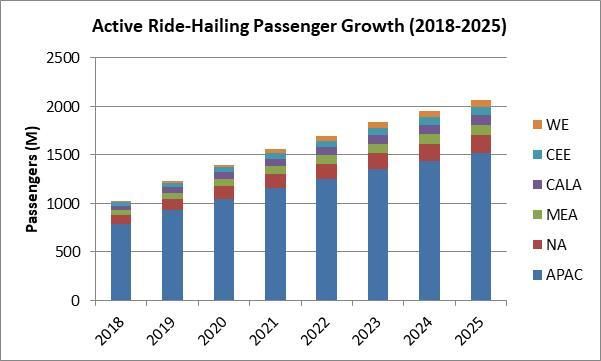
Wireless Media

With the proliferation of sensors and connectivity location platforms enable
enterprises and developers to integrate first-party data and third-party data with
map content and location services to create their own custom maps, data
visualizations, or unique location insights. For example, a real-estate agent
comparing average property prices across a town or city, or retailers mapping
cell tower or GPS data traces to identify high-footfall locations within towns.
Location platforms can deliver solutions off-the-shelf or customized depending
on customer needs.

2.2 Map Making & Maintenance Evolution
The future of map making continues to evolve towards the capture of reality in
sub-meter detail and context with increasing automation and reliability.

The proliferation of sensors, connectivity, computer vision and edge and cloud
(ML/AI) processing are all playing a role in creating highly accurate maps with
sub-meter precision and scale. As is the falling costs associated with capturing
high-definition imagery, lidar and other map data inputs. These maps support a
variety of increasingly sophisticated use cases, delivering precision and accuracy
to drive competitive advantage for companies which use them.

Map making and map maintenance is complex and requires significant
investment and expertise in acquiring, extracting, and orchestrating flows of
different datasets and content at scale. Only a handful of companies, including
Google, HERE, TomTom and Mapbox, have the capabilities and resources to
make and maintain maps at a global level. Over time, map making techniques
have become increasingly sophisticated, automated, scalable, and cost
effective. Machine Learning (ML) and Artificial Intelligence (AI) assists greater
levels of automation in mapping. Modern map-making and maintenance
requires normalizing, combining and conflating data from many different
sources, each with pros and cons. Sources include imagery and data captured by
mapping vans, satellite and arial imagery, crowdsourced data (ranging from
manual edits, photographs, and computer vision), GPS probe data, and in future
inputs from a broad range of IoT sensors. Imagery from low earth orbit satellites
will also assist. Some of the pros and cons of each approach (though not
exhaustive) have been outlined in our previous report.

© Strategy Analytics 2021 All Rights Reserved | www.strategyanalytics.com                         7
Wireless Media

3. Pandemic Opportunities and
Challenges
The COVID-19 pandemic has presented both challenges and opportunities to the
location industry with restrictions to movement and the closure of large parts of
the economy (e.g. leisure and entertainment) lowering demand for location
services. Simultaneously, location data and services have been required to assist
with the pandemic response and to meet growing demand for home deliveries.

2020 was a challenging year for the location sector. Significantly fewer people
travelled as normal, and economic uncertainty led to consumers delaying or
cancelling the purchase of big-ticket items, like a new car. Travel has been
negatively impacted on several levels with stay-at-home orders, the closure of
meeting and entertainment venues, and personal health concerns all playing
contributing roles. According to Strategy Analytics’ Connected Mobility research,
travel behavior has started to adapt. Use of public transport on buses, trains and
trams has declined significantly, partly a result of restrictions but also due to fear
of the strong potential for virus transmission in busy and enclosed carriages. This
has resulted in a boom in sales of private mobility options (e.g. bicycles,
scooters) and to membership rates to bike, scooter and car sharing services.

There is evidence that financial uncertainty created by the pandemic hit the
consumer automotive market, with sales of new vehicles declining. Consumer
research conducted by Strategy Analytics towards the beginning of the
pandemic shows that between 22% and 26% of consumers across the Germany,
UK and the US indicated they were likely to delay or cancel purchasing a car due
to COVID-19. The same figure was 49% in China. Vehicle purchase has shown
positive signs of rebounding though has yet to return to pre-pandemic levels.

The fall in personal and business-related travel is reflected in Strategy Analytics’
AppOptix USA panel which highlighted sharp year-on-year declines in the use of
apps in the transport and travel categories, including taxi hailing apps. It was
also reflected in announced workforce cuts by companies operating in the
mobility sector, although there are also signs of recovery here:

© Strategy Analytics 2021 All Rights Reserved | www.strategyanalytics.com                             8
Wireless Media

•    In September 2020 Waze laid-off 5% of its staff (30 people) and closed
     offices in Asia Pacific and Latin America, as advertising demand slumped.
•    In June 2020 HERE Mobility announced the closure of its HQ in Israel with
     200 job losses.
•    Mobility companies such as Uber, and Lyft, and business review site Yelp,
     also announced job cuts due to the pandemic.

The pandemic has also brought into focus the positive role of location services in
supporting the pandemic response in a variety of different ways:

•    Governments and public healthcare authorities have relied on map and
     location services to visualize the spread of the virus across towns, cities,
     and regions in their countries and to identify potential hotspots.
•    GPS probe and cell-tower data have been used to anonymously track the
     movement of citizens to measure the extent to which the public is
     complying with lockdown measures.
•    E-commerce and home delivery have boomed due to stay-at-home
     orders, placing greater demand on the transport and logistics sector,
     particularly last-mile delivery providers. Location services have played a
     role in enabling delivery drivers to optimise journeys to meet these
     increased demands.

     •   Some local businesses and organizations have been forced to adapt
         their business model to provide delivery services to respond to the
         shift to online deliveries.

•    Information about changes to store opening times, guidance on peak
     times in shops or on public transport, the availability of bicycles at bike
     sharing hubs, and other location intelligence has increased as consumers
     adapt their behaviour to fit rules and minimise the risk of infection.

Strategy Analytics believes there is reason for optimism that the world will return
to some level of normalcy over the next few years due to vaccines, combined
with shifting consumer behaviors, like observing social distancing.

© Strategy Analytics 2021 All Rights Reserved | www.strategyanalytics.com                          9
Wireless Media
4. Evolving Location Sector Demands
Location services and location intelligence can support a diverse variety of use
cases across multiple sectors including automotive, fleet management, asset
tracking, business intelligence, digital advertising, and consumers applications.
Demand for location services and location enhanced insights continues to Location services
expand across all sectors driven by their ability to deliver both operational enable companies
efficiency and performance benefit for businesses, e.g., improved cost to achieve
effectiveness, better risk management, and effective decision making. competitive
advantage, through
Even within established use cases the demands on location services and cost effectiveness,
location intelligence are evolving. For example, location services like maps and better risk
navigation are core components of the vehicle infotainment system. However, as management and
the automotive industry evolves to support assisted and autonomous driving, improved decision
and electrical vehicles (EV), location services also need to adapt to meet making.
changing demands.
Sophisticated 3D model with high levels of accuracy and attribution are enabling
new experiences via mixed reality e.g. AR navigation and AR place search, and
powering digital twins designed to simulate and predict real-word events, and
train Artificial Intelligence.
The rest of this section provides examples of the growth opportunities in some of
the main areas targeted by companies in the location-sector.
• The automotive industry
• The on-demand and mobility market
• Enterprise – asset management and IoT
• Consumer mobile applications
• Digital advertising and marketing
4.1 The Automotive Sector
Several forces are influencing the evolution of the automotive sector, creating
both opportunities and threats for location companies:
© Strategy Analytics 2021 All Rights Reserved | www.strategyanalytics.com 10Wireless Media
• Rising penetration of vehicles with both embedded navigation and data
connectivity to meet consumer needs.
• The desire of regulators and carmakers to increase road safety by
providing increasing levels of assistance and support to drivers.
• Growing consumer and legislative demand for environmentally friendly
electric vehicles (EV).
• Falling levels of car ownership and rising demand for mobility services,
particularly in cities.
New vehicles with built-in navigation are becoming standard and will provide an Strategy Analytics
opportunity for growth for in-vehicle navigation suppliers. Furthermore, in- expects the attach
vehicle connectivity (on-board and brought in) is driving the growth of rate for navigation
connected navigation services and live location content. to rise from 38% of
cars sold in 2020 to
For carmakers, embedded and connected location services, such as turn-by-turn nearly 70% by 2026.
(TBT) navigation, traffic information, point-of-interest (POI) search (including
parking and gas stations), will remain an important component of in-vehicle
infotainment systems (IVI) over the next five-years. Specifically, navigation
systems are becoming common in entry-tier vehicles. Strategy Analytics expects
the attach rate for navigation to rise from 38% of cars sold in 2020 to nearly 70%
by 2026 creating a significant growth opportunity for suppliers.
A sizeable drop in new vehicle sales in 2020, due to the pandemic, has resulted in
more than a 20% decline in navigation unit shipments versus Strategy Analytics
pre pandemic estimates, although annual volumes will make a significant
recovery by the end of the forecast. Despite the negative impact of the pandemic
over the next 5 years, Strategy Analytics’ Infotainment and Telematics service
estimates annual sales of navigation enabled cars will almost double from over
34.5 Million at the end of 2020 and exceed 68 Million by 2025, Exhibit 3. This total
excludes HD maps required to safely guide autonomous cars but includes
connected cars which will have the ability to deliver live map-based services to
users as part of the connected in-vehicle infotainment (IVI) experience.
Furthermore, Strategy Analytics estimates the penetration of vehicle shipments
with embedded cellular connectivity (2.5G and above) will rise from 46% in 2020
to 66% by 2025. Greater connectivity not only enables drivers to get access to up-
to-date maps instead of relying on outdated embedded maps, but also routing
based on up-to-date traffic conditions, live hazard warnings and potentially real-
© Strategy Analytics 2021 All Rights Reserved | www.strategyanalytics.com 11Wireless Media
time parking availability information. In depth analysis and forecasts of the
infotainment services and telematics opportunity is available through Strategy
Analytics’ Infotainment and Telematics service.
Exhibit 2 Annual Sales of Navigation Enabled Cars: 2019-2025
Source: Strategy Analytics, Infotainment & Telematics
Road safety remains an important priority and responsibility for governments
and carmakers. Therefore, the penetration of ADAS capabilities in new vehicles Strategy Analytics
will continue to grow as governments introduce car safety legislation and auto expects the global
makers promote the safety features of their vehicles to consumers. penetration of the
distance warning
As the automotive industry aims to enhance road safety, with the aim of feature to reach
reducing and possibly eliminating accidents caused by vehicles, the provision of 76% of light duty
sophisticated driver assistance features, known as advanced driver assistance vehicles in 2025,
systems (ADAS), will become a common feature in modern cars. For example, with a growing
Strategy Analytics expects the global penetration of the distance warning feature share 25%-33% of
to reach 76% of light duty vehicles in 2025, with a growing share (likely between these relying on an
a quarter and third) of these relying on an ADAS map. Other examples of ADAS ADAS map
features include distance warning predictive powertrain, intelligent speed
assistance, and lane departure alerts.
© Strategy Analytics 2021 All Rights Reserved | www.strategyanalytics.com 12Wireless Media
The automotive sector is also moving slowly and steadily towards more
autonomous driving, which will be enabled in many cases by some form of high
definition (HD) map offering accuracy in the centimetres range.
• However, there are still significant voices casting doubt on the scalability
of autonomous vehicles that are reliant on multi-gigabyte HD maps
gathered by survey vehicles. Vision-centric companies such as Tesla and
Mobileye, although still very much using mapping data, are typically
looking to a lighter-weight, user-gathered data set. The aim is to enhance
the autonomous ride, not for the vehicle to be 100% reliant on accurate
HD mapping data for its operation.
Over the next five to ten years, fully autonomous vehicles will account for a
negligible share of vehicles sold. Strategy Analytics only expects the penetration
of fully autonomous vehicles light-duty vehicles to start ramping up in the 2030s.
However, the penetration rate of Level 2 (L2) capable vehicles (offering similar
capabilities to today’s autopilot-enabled Tesla models) will likely have hit over
50% of annual production in 2030. The battle worth winning will be for the maps
that these vehicles need to support their operation.
Beyond supporting autonomous vehicles in the real world, accurate and
detailed location models of cities and roads can also be used to train and test
self-driving AI/ML algorithms in a virtual environment. Google’s Waymo states
that the AI agent powering its self-driving solution has driven over 20 Million
miles in simulation.
The shift to cleaner electric vehicles is being accelerated by both governments
aiming to meet environmental targets and vehicle makers responding to a
combination of legislation and demand from consumers.
Sales of environmentally friendly electric vehicles (EV) are rising due to a
combination of regulations and consumer sentiment. In November 2020 the UK
government announced it will bring forward the date for the end of sales of non-
electric cars to 2030, five years sooner than its initial guidelines. Japan is aiming
for the same goal by 2035. In February 2021 Jaguar announced its aim to only
produce electric vehicles by 2025. In January 2021 GM announced similar aims
by 2035.
© Strategy Analytics 2021 All Rights Reserved | www.strategyanalytics.com 13Wireless Media For a growing number of EV owners knowing the effective driving range of their vehicle and finding the location of suitable electric charging points along routes is critical to enabling a worry-free EV driving experience. Therefore, demand for live information relating to the availability of these charging points and EV- friendly parking spots will remain important as EVs become more popular. The total cost of car-ownership versus alternative transport options, road congestion in urban centres, and environmentally friendly attitudes are all contributing factors to declining rates of car ownership in busy cities. Therefore, a range of mobility services, including taxi-hailing, car sharing, pedal-cycle sharing, e-bike and scooter sharing initiatives have emerged to provide alternative means of transportation and mobility in congested locations. 4.2 The Mobility and On-Demand Sector The mobility sector covers a broad range of on-demand use cases, including ride-hailing, car sharing, micro-mobility, autonomous shuttles, and the concept of mobility-as-a-service, which aggregates different mobility options into a single interface with the aim of presenting options that best fit traveller needs. Location content and location services lie at the heart of these mobility use- cases, whether that is in the form of a digital map to enable passengers to locate the nearest car sharing vehicle, via their smartphone, or routing, navigation and traffic services to assist drivers of taxi-hailing services locate passengers, or a dispatch solution for taxi fleets. Furthermore, the growing use of smartphone centric mobility applications has been enabled by increasing smartphones ownership, growing consumer use of mobile payments, and improving access to large bundles of mobile data (4G and 5G), particularly in emerging mobile data markets. Not surprisingly, the pandemic has had a negative impact on the mobility sector during 2020 due to travel restrictions. With the closure of entertainment and hospitality venues, restricted travel and quarantines, demand for mobility services has plummeted significantly during 2020 but has started to rebound in early 2021. Consumers will understandably exercise greater caution towards public transport options, such as buses and trains. However, Strategy Analytics believes this has benefited mobility services (like taxi-hailing, car-sharing, © Strategy Analytics 2021 All Rights Reserved | www.strategyanalytics.com 14
Wireless Media

scooter-sharing and bike sharing) because consumers that previously relied on
public transport to make journeys have shifted to socially distanced mobility
alternatives. As the world returns to normalcy due to the positive impact of
vaccines, we expect demand for mobility services to continue to rise across all
markets and regions.

Demand for ride-hailing services is being driven by a combination of strong price
                                                                                         Demand for ride-
competition among providers and the convenience of booking rides via
                                                                                         hailing will
smartphone apps. Strategy Analytics Connected Mobility service expects
                                                                                         continue to rise to
demand for ride-hailing to continue to rise out to 2025, with a doubling in the
                                                                                         2025, with a
number of active users of ride-hailing services from just over 1 Billion in 2018 to
                                                                                         doubling in the
over 2 Billion by 2025, Exhibit 3. A significant driver of this growth in ride-hailing
                                                                                         number of active
services will come from Asia, which will account for three-quarters of all active
                                                                                         users of ride-hailing
users in 2025. Strategy Analytics’ Connected Mobility research provides a deep
                                                                                         services from just
dive into the mobility sector, including forecasts for ride-hailing and car-sharing.
                                                                                         over 1 Billion in
                                                                                         2018 to over 2
Strong demand for on-demand ride hailing apps, such as Uber, Lyft, Didi and Ola
                                                                                         Billion by 2025,
has created a need for traditional taxis-fleets to close the technology gap and
offer similar consumer experiences. This includes providing taxi booking apps for
consumers which enable consumers to track their assigned car, access details of
the make, model, colour, registration number, and driver of the car, and view up-
to-the-minute estimated time of arrival (ETA), among other features. Location
platforms provide mobility companies with a competitive advantage by
providing accurate detailed addressing and ETAs based on live traffic
information. Accurate ETAs and slick pick-up and drop-off at target destinations
increases the satisfaction of both customers and drivers. Taxi-hailing has been a
key battle ground and area of focus of focus location platforms.

© Strategy Analytics 2021 All Rights Reserved | www.strategyanalytics.com                                      15
Wireless Media
Exhibit 3 Global Active Ride-Hailing User Growth: 2018-2025
Source: Strategy Analytics, Connected Mobility
Providers of mobility solutions are looking for partners which can deliver
competitive advantage for providers in terms of performance, cost, and user-
experience for passengers and drivers. For example, providing traffic optimised
routing to enable drivers to maximise the number of trips and passengers with
accurate estimated times of arrivals (ETAs).
4.3 Enterprise
Achieving competitive advantage through location insights continues to drive
demand for both off-the-shelf and customized location intelligence solutions
across different industry sectors and business functions.
The benefits of digitalization is felt at various levels across enterprises, e.g. sales
and marketing, operations, strategy, IT management and R&D. Data is being
collected and analysed to generate insights that improve decision making,
accountability, efficiency, and business performance.
Location intelligence refers to the combination of mapping and geospatial
services with a company or organisation’s own data. Location intelligence is a
subset of business intelligence, whereby a business visualizes data it generates,
© Strategy Analytics 2021 All Rights Reserved | www.strategyanalytics.com 16Wireless Media
e.g. performance data, pricing, and cost data, etc. on a map (or applies location
services to it) for improved tactical and strategic decision making.
Use-cases for location intelligence include geo-marketing, location-targeted
advertising, site location planning (e.g. retail stores, restaurants, fuelling stations
and other infrastructure like mobile radio access networks) and remote
equipment performance monitoring. Asset tracking, fleet management, on-
demand/ mobility services, and other business functions can also be enhanced
with location services.
A BCG global survey on location intelligence for enterprise conducted across 520
in October 2020 shows high levels of importance of location data to business
performance across different sectors, including real estate, logistics and delivery,
and retail and e-commerce, Exhibit 4. Strategy Analytics plans to assess the
status of location service deployments across various verticals through its own
enterprise mobility survey later in 2021.
Exhibit 4 Importance of Location Intelligence to Business Performance, By
Sector
Asset tracking and fleet management are covered in more detail below.
© Strategy Analytics 2021 All Rights Reserved | www.strategyanalytics.com 17Wireless Media
4.3.1 Asset Tracking & Fleet Management
Location services including maps, geo-location, geofencing, and others enable
Vehicle tracking,
assets such as fleets of vehicles, parts, and employees to be tracked across the
traffic optimized
supply chain. Location services deliver transparency, improved accountability
multi-point routing,
and optimization for both suppliers and buyers.
assessing driver
behaviour, and
Vehicle tracking, traffic optimized multi-point routing, assessing driver
logging trip
behaviour, and logging trip information offered by fleet management solution
information offered
providers are all underpinned by maps and location services. Fleet telematic
by fleet
solution provider, Verizon Connect, surveyed 700 US fleet managers in its 2021
management
Fleet Technology Trends Report and noted that over 50% of highlighted
solution providers
improvements in customer service and productivity functions after
are underpinned by
implementing GPS fleet tracking. Furthermore, just under 50% highlighted a
maps and location
positive improvement in routing. The study also noted a 41% improvement in
services.
vehicle maintenance for respondents in the transportation sector and a 53%
decrease in fuel consumption for those in the services industry.
Maps and location services such as geolocation, geocoding, routing, and
navigation are useful for tracking products across the supply-chain, from within
factories through to delivery to the customer. For example, as parts or assets
move from inside to outside the factory, dispatchers can track the position of
their vehicles in real time to provide improved guidance to internal and external
customers relating to estimated arrival time. Dispatchers can also use
information about potential delays due to traffic incidents to provide drivers
with alternative routing information. Furthermore, the digitization of the
distribution and logistics sector is enabling haulage companies to use location
services and real-time information to optimize and maximize fleets of trucks and
minimize underutilized capacity.
The economic viability of cellular enabled asset management tags has improved
due to a combination of lower priced cellular enabled RFID tags and falling
mobile data prices. The battery performance (and therefore lifecycle) of cellular-
enabled tags has increased significantly, which is also making them more viable.
Strategy Analytics expects a 12% CAGR in the number of cellular IoT connections
between 2020 and 2026 to drive demand for location services. Enterprises need
© Strategy Analytics 2021 All Rights Reserved | www.strategyanalytics.com 18Wireless Media
to monitor the location and movement of assets to deliver greater
accountability, enhance customer satisfaction, and to improve decision making.
Strategy Analytics
Increasing numbers of IoT providers are offering location and tracking out of the expects a 12%
box, not just around cellular, but also around unlicensed LPWA technology like CAGR in the
LoRaWAN. Customers will increasingly have a choice beyond assisted GPS, number of cellular
depending on power consumption and the level of accuracy required for their IoT connections
solution. Some companies may just need to know where an asset is with basic between 2020 and
geo-fencing. For example, warehouse assets like cable drums or the basic 2026 to drive
position of enterprise fleets to track those assets to a specific depot or location, demand for
which may not require a high level of accuracy. In those cases, even unlicensed location services
LPWA technologies like LoRa may be sufficient, as long as the network knows
what time a signal is picked up by any number of gateways, so that it is possible
to triangulate that to a location with an accuracy of 40-50 meters, perhaps
slightly less in dense urban environments.
For greater levels of accuracy, integrated AGPS/cellular/Wi-Fi sniffing will work
very effectively, such as specific pallet locations or where in a storage rack an
item is located. Some companies are also integrating these capabilities into
unlicensed LPWA solutions, such as Actility, which has some patented IP
around low power GPS (through its acquisition of Abeeway), which is a LoRaWAN
equivalent of AGPS (Assisted GPS). The network provides key information to the
device preparing to make a fix, which means that the GPS can be active for a
shorter period and acquire fewer satellite signals. The position calculations are
then processed in the cloud, which reduces the battery impact, while still
providing GPS levels of accuracy (in many cases sub-10 meters). If a standard
GPS offering has a 1-year battery life and pure LoRaWAN has a 10-year battery
life, this solution could give up to 9 years1
Location services will also be used to enhance augmented reality (AR) which will
create a more immersive experience. AR and real-time location services (RTLS)
will be combined on a much bigger scale to provide value to businesses and
customers. In fact, the trend has already begun with airports and hospitals using
1
https://www.actility.com/customer-stories/die-mobiliar/
© Strategy Analytics 2021 All Rights Reserved | www.strategyanalytics.com 19Wireless Media
BLE Beacons, combined RTLS and Wi-Fi to help staff and passengers find their
way through their complex and difficult to navigate spaces.
IoT presents a future growth opportunity for location platforms as the number of
devices connected to the internet increases. Strategy Analytics’ Enterprise IoT
Strategies service estimates the number of devices connected over the cellular
network is set to grow at a 12% CAGR between 2020 and 2026 across a variety of
industry verticals, Exhibit 5. IoT in Healthcare, is set to show the strongest
growth, followed by Security, Primary Processing and Automotive. Cellular
connectivity will enable enabled equipment to be tracked or monitored,
although clearly not all these connected devices will need support from
geospatial services e.g. geolocation, directions, or routing.
Exhibit 5 Global Cellular IoT Connections: 2020-2026
Fundamentally, where mobility is a core requirement e.g. automotive, or fleet or
where assets need to be tracked e.g. in a factory, or across a supply chain, the
greater the need for geolocation services. Traceability in the supply chain is
becoming a very important element of compliance in many industries to
guarantee the source of origin, as well as the integrity of any component.
Examples include car parts shipped globally to different suppliers, where
location tracking and identification of the origin is vital, especially in terms of
liability should there be a safety recall on a particular vehicle component. The
© Strategy Analytics 2021 All Rights Reserved | www.strategyanalytics.com 20Wireless Media
same is also true in terms of food processing, where traceability is vital in
guaranteeing the integrity of a finished product, for example, if a fast food chain
guarantees customers that chicken nuggets contain 100% chicken breast meat,
then suppliers need to ensure they can prove that the chicken nuggets they
produce are sourced from chicken breast, or risk a serious breach of an SLA
(service level agreement) with a customer.
Data recorded by these connected objects will be able to provide contextual
information via alerts and can be visualized. For example, a vending machine
which is low on a certain product item, or which has become faulty is able to
communicate its status to head office and can be restocked or fixed.
4.4 Mobile Apps and 5G Networks
From a volume perspective mobile phones, and in particular smartphones,
remain the primary device through which consumers access location-enabled
services, such as map apps, turn-by-turn navigation apps, local business search,
taxi-hailing apps, and location-based games, among others.
While all-in-one travel applications depend on location services, many apps are The addressable
enabled with location awareness to provide contextual relevance. e.g. location market for
sensitive weather and news, or to prevent content being viewed by users outside consumer LBS will
authorised geographies determined by content rights holders. More broadly, rise. Annual sales of
basic location services also include store locators which usually consists of a GPS enabled
location input box, a map, markers, and results including travelling distance smartphones will
from the users’ postal code. grow from just
above 1.21 Billion
Over the next 5 years, the rising population of consumers with GPS handsets in 2021 to 1.5
combined with a growing base of mobile data users and app-stores users will Billion by 2025.
boost the addressable market for different types of consumer LBS.
GPS handsets: Annual sales of GPS enabled smartphones, which support
accurate geolocation, is set to rise from just above 1.21 Billion at the end of 2021
to just over 1.5 Billion by the end of 2025, according to Strategy Analytics’
Emerging Device Technologies service.
© Strategy Analytics 2021 All Rights Reserved | www.strategyanalytics.com 21Wireless Media
App-store users: Strategy Analytics estimates the population of users accessing
app-stores to download apps and games will rise from just above 3.2 Billion at
the end of 2019 to over 3.6 Billion at the end of 2025, thus increasing the
addressable market of users able to download location-based applications.
Mobile data users: Apps and services which rely on location-based services
served in real-time are dependent on mobile data connectivity when they are
out and about. The number of mobile data users is set to exceed 4.4 Billion by
2025.
4.4.1 5G Networks
Mobile operator network planners typically lean on maps, location services, and
other segmentation data to plan the deployment of radio access networks (2G,
3G, 4G) at both a macro and micro level. However, with 5G more sophisticated
and detailed 3D maps will be required, particularly in dense urban environments
where service providers are aiming to deploy 5G using mmWave. Although 5G
mmWave offers higher bandwidth, its coverage range is limited and prone to
interference from both hard and soft physical features, such as lamp posts and
tree foliage, respectively. Consequently, maps providing accurate 3D models in
tandem with RF propagation tools will enable mobile operators to optimise the
positioning of their 5G RAN to provide the best possible signal and coverage.
5G deployments are continuing to ramp up, which is reflected in 5G subscriber
growth forecasts. Strategy Analytics expects strong growth in 5G network
deployment over the next 5-years as the number of 5G subscribers expands
almost 4-fold from just over 700 Million at the end of 2021 to 2.8 Billion by 2025.
4.5 Location-Based Advertising & Marketing
Geolocation underpins growth of the $470 Billion global digital advertising
ecosystem in three ways:
• Audience segmentation: Correlating the geolocation of mobile device IDs
(anonymously) against a database of places (and their boundaries)
provides audience insights that underpin ad targeting. The places that
people visit, along with other contextual information such as time of day
© Strategy Analytics 2021 All Rights Reserved | www.strategyanalytics.com 22Wireless Media
(and inferred home and work locations) can assist digital marketers to
build anonymised profiles and personas which support targeted
advertising.
• Digital advertising attribution: Accurate user location information allows
advertisers to measure the extent to which digital advertising drives in-
store visits. Google has been measuring store visits (anonymously) since
2014 and is using this information to demonstrate the uplift in store traffic
because of digital advertising campaigns.
• Location and proximity ad-targeting: The direct use of location to target
users with messages based on their location or proximity to specific
physical locations using geo-fencing. For example, Google AdWords
enables advertisers to program their bids for searches on keyword
searches conducted within advertiser defined locations. Equally, local
business can leverage user location to prevent them from advertising to
potential customers located in different towns or cities.
Despite the importance of location data to digital advertising, location fraud
remains a key challenge, as highlighted in our previous reports. A study
conducted by Location Sciences, a location intelligence company, during 2019
estimates up to 65% of spend on location targeted impressions is outside of the
targeted area or based on signals of insufficient quality to meet location
targeting needs. Privacy is also becoming an increasingly important issue, with 6
in 10 US respondents to a short directional survey indicating rising concern over
the past 12 months. Strategy Analytics also expects Apple’s decision to make
device identifiers for advertisers explicitly opt-in for each app to have a negative
impact on the quality of geolocation data available in ad-exchanges when it is
implemented later in 2021.
5. Location Platform Benchmarking
Each of the location companies in our annual benchmark has enhanced,
existing offerings, expanded their portfolio of products and solutions, and added
partners and clients.
The following (non-exhaustive) highlights for Google, HERE, Mapbox and
TomTom during 2020 and early 2021 include:
© Strategy Analytics 2021 All Rights Reserved | www.strategyanalytics.com 23Wireless Media Google: Google has scored wins with Ford in the automotive sector, in addition to Daimler Trucks and Fiat Chrysler via Waymo its autonomous driving unit. Google’s consumer facing app, Google Maps, enables Google to quickly understand changing consumer needs, which it can rapidly address. For example, Google bolstered bike lane content after seeing a spike in searches for cycle routes due to the pandemic. Google has also improved the ability of developers to customise its maps and map content (e.g. POIs) to meet their business needs, e.g. customise zoom levels, POIs and map-styles more conveniently. Google serves a large base of developers, and it has highlighted Green Wheels, Licious, Namco-Bandai, Gojek as a few of many companies using its location capabilities to support their needs. HERE: with the pandemic halting vehicle production in 2020 HERE’s automotive revenues took a hit. However, the company grew its non-automotive bookings in the multiple double-digit range. HERE is positioning for growth in both automotive and non-automotive domains (e.g. transport and logistics, telecoms, media/ advertising and technology, and infrastructure and planning). HERE’s location data marketplace gained traction with APCOA, Global Weather Corp., RoadCloud and Zenrin, and others. HERE’s platform approach positions it well for a rise in demand for location intelligence capabilities as the proliferation of IoT sensors generates ongoing data. In automotive HERE lost Ford as a map customer to Google. However, Ford is using HERE’s Hazard Warning service and is using HERE Workspace to develop its Active Driver Assist (SAE Level 2+) product for North America. During 2020 HERE announced wins and partnerships with a variety of companies with different location needs, including Amazon, Blueshark, and Shebah, among others. HERE’s direct developer program has seen double digit growth in the numbers of developers using its platform. Asian remains important to HERE’s future growth and will be aided by new investment from Mitsubishi Corp. and NTT in Japan, with both companies holding a combined 30% share of HERE, which closed mid-2020. Mapbox: Mapbox continues to benefit from its strength in map design and data visualization. Tableau and Arcadia Data are both leaning on Mapbox to power map-based visualizations in their analytics platforms. It has enriched visualization by adding 135 square KM of high-resolution satellite imagery and added rich APIs which can be accessed via the new version of its map API (Mapbox JS GLv2). Mapbox JS GLv2 which it intends to support going forward is © Strategy Analytics 2021 All Rights Reserved | www.strategyanalytics.com 24
Wireless Media

not open source. Mapbox has also noted its Vision SDK mapped and streamed 1
Billion images and refreshed over 15 Million traffic signs in the US. Mapbox also
announced a significant win in automotive, with BMW. BMW’s navigation
solution will be powered by Mapbox navigation software. Mapbox is targeting
growth in Japan through a joint venture with its investor, Softbank. Mapbox has
grown its monthly active developer base to 170 K from 150 K during 2019
Mapbox’s location services are being used by large consumer services including
Facebook, Snap, CNN, Yahoo Japan, The Weather Channel, Tableau, Strava and
Wordpress, among many others.

TomTom’s automotive revenues took a hit in 2020 due to the pandemic, though
it notes strong growth in orders during the year will drive revenue for 2021 and
beyond. In the automotive space TomTom remains a leader in navigation
software with 15 OEMs deploying its NavKit. It has highlighted wins with brands
within the Stelantis Group, Mitsubishi Motors, Maserati, Daimler Trucks, to
supply navigation and location services. It also claims to have sold over 3M
vehicles powered by its ADAS maps. In HD and autonomous driving TomTom a
proof of concept with Toyota Research Institute for rapid HD-map development.
TomTom has also successfully grown the base of location developers through its
portal, and impressively claims over half are being monetised. Beyond
automotive, TomTom continues to expand its relationship with Microsoft.
TomTom’s location services are being used to power Azure Maps, Bing Maps. It is
also supporting Huawei’s MapKit (and Petal Maps app) and Verizon Direct.
TomTom also extended its deal with data intelligence platform, Precisely, and
expanded its relationship with Uber. Uber has joined TomTom’s certified Map
Editing Partnership program to enhance its map maintenance. TomTom’s deal
with Foursquare for POIs provides a boost its place search capabilities.

5.1 Benchmarking Update & Result Summary
Strategy Analytics benchmarks the relative strengths and weaknesses of Google,
HERE, Mapbox and TomTom across seven critical categories that are relevant for
a broad range of location services users.

The categories being used to evaluate the location platforms include map
making and freshness, POI search, developer community, automotive, map and
data visualization, openness and flexibility, and growth and leadership:

© Strategy Analytics 2021 All Rights Reserved | www.strategyanalytics.com                       25
Wireless Media

Map making and maintenance: Providing reliable, fresh, and up-to-date maps
and map content has become table stakes and expected in the era of “on-
demand” services. Location platforms which have the capability to deliver near
real-time map attribute updates to customers will score highly in this category.
As will companies that apply a robust and holistic approach by conflating
multiple data sources and applying stringent verification. Platforms that develop
maps to meet emerging and future needs (EV, ADAS, autonomous, AR/XR, etc)
will also score well.

Search and Point-of-Interest: One of the key location services is the ability to
search for local businesses, buildings, and attractions with high levels of real-
time accuracy. Therefore, the size, freshness, and accuracy of the database of
places provided by location platforms are key metrics. Higher scores in this
section are awarded based on a combination of the size of place database, how
frequently it is updated, its granularity and ability to customize results for
specific use-cases.

Developer community: The location-sector is in the process of evolving from a
model where historically enterprises and businesses licensed the map content
and services, to a model where they can access a broader set of location
capabilities, including map tiles, geocoding, routing, place search, traffic data
and more, through application programming interfaces (APIs). A high score in
this section is awarded to platforms that have captured a large share of
developers of all types, and that provide a broad range of tools for developers.

Automotive: The automotive sector remains a critical source of revenue and
demand for the location sector, and therefore the ability to service both current
and emerging needs of vehicle makers cannot be ignored. In this category we
award higher scores to companies which have announced deals and
partnerships to supply key players in the automotive space with location
services and solutions.

Map and data visualization: The need to provide customized map views and
visualization of location data is likely to vary significantly according to both use-
case and company. Some companies may want to provide a highly customized
type of map to suit a specific use-case, or to toggle between different
visualization options for a specific dataset. In contrast, for other companies it will

© Strategy Analytics 2021 All Rights Reserved | www.strategyanalytics.com                            26
Wireless Media

be less important to customize either map or data visualization. Companies
offering the broadest and most customizable set of data visualization solutions
will score highly in this segment.

Openness and flexibility: Providing an open and flexible location platform means
enabling companies to layer in their own location data onto the map, or to pick
and choose which location services to use from different providers. Also, some
companies may want to customize certain features and capabilities, e.g. a
retailer filtering the location of its own stores in the results of a search query or
customizing some code or an open API request.

Industry growth and leadership: As highlighted in section 4 of the report the
opportunities for growth in the location sector will come from supporting
autonomous vehicles, the on-demand mobility sector, and a rising demand for
location intelligence with respect to asset tracking, fleet management, and IoT
as businesses embrace big data. Companies which communicate strong growth
ambitions across some of these key location sectors, either directly or through
partnerships will score the highest marks.

5.2 Benchmarking Category Results
Competition in each category remains fierce between platforms Google, HERE,
Mapbox and TomTom. The importance of different capabilities and strengths
varies based on use-case, sector, and individual company requirements with
HERE leading overall and Google and TomTom following.

Google: Google is a leader in POI search, map making/ freshness, and developer
community. It is also making good progress in automotive infotainment and
autonomous driving via Waymo. Google’s closed approach to competition in
listings, directories, advertising, navigation, and sharing data remains a
weakness for businesses and developers seeking openness and flexibility.
Google has made progress in data visualisation, map styling and map
customisation. Despite leading in breadth and depth of POI and place
information, managing fake business listings remain an on-going challenge.
Google leads in the developer category by virtue of its base of millions of
developers. However, Google’s high pricing continues to leave it vulnerable to

© Strategy Analytics 2021 All Rights Reserved | www.strategyanalytics.com                           27
Wireless Media

competition as HERE, Mapbox and TomTom aiming to attract disaffected Google
Map developers looking for alternatives.

HERE: HERE leads the overall scores and remains a leader in automotive and
location industry growth vision categories. HERE is a co-leader in openness and
scores strongly in map-making and freshness and has improved its score in
visualisation. HERE remains an automotive leader in Western Europe and North
America, despite the rising threat from Google. Since 2017 HERE has sold 17
Million vehicles that rely on its ADAS supported map functions to power L1 and
L2+ automation. HERE is both independent, and open, retaining ambitions to
provide a variety of solutions, products and platforms to any enterprise looking
to develop, monetize and leverage location intelligence and location data. HERE
has strong roots in supplying location content and services to automotive
companies and large enterprises, and continues to enhance capabilities (e.g.
visualization, map content, developer tools) to address emerging and growth
opportunities aligned with its target areas across automotive, transport and
logistics, telecommunications, media and technology.

Mapbox: Mapbox is a leader in map design, customization, and data
visualization. Mapbox is developer friendly, coming second to Google based on
the reported size of its developer community. It is also a co-leader in openness
and remains independent and flexible. However, it’s worth noting its , Mapbox’s
reliance on OSM is perceived a weakness for enterprises and industries where
the consistency, provenance and quality of map data is considered essential,
though this has not prevented Mapbox from gaining traction with businesses
across a broad range of sectors. BMW selected Mapbox for its navigation
software but Mapbox continues to play at the margins in automotive.

TomTom: TomTom’s scores very strongly in map-making and freshness,
automotive, and is a co-leader in openness - as an independent player it enables
developers to mix and match location and data sources. TomTom has improved
its score in visualization and POI search, and it has made progress in attracting
developers through its strategic partnership with Microsoft’s Azure, Huawei and
Verizon Direct. TomTom reports double digit growth in direct developers with
over half monetized. Despite challenges due to the COVID-19 pandemic
TomTom remains strong in automotive, with leadership in navigation software
and reported traction for its ADAS maps among OEMs - over 3 Million ADAS

© Strategy Analytics 2021 All Rights Reserved | www.strategyanalytics.com                       28
You can also read