MINUTES Ordinary Council Meeting Tuesday, 3 March 2020 - Date: Tuesday, 3 March 2020 Time: 7.00pm - Town of ...
←
→
Page content transcription
If your browser does not render page correctly, please read the page content below
MINUTES
Ordinary Council Meeting
 Tuesday, 3 March 2020

     Date: Tuesday, 3 March 2020
     Time: 7.00pm
  Location: Town of Claremont
            Claremont Council Chambers
            308 Stirling Highway, Claremont

                                              Liz Ledger
                               Chief Executive Officer
Ordinary Council Meeting Minutes                                               3 March 2020

DISCLAIMER

Would all members of the public please note that they are cautioned against taking any
action as a result of a Council decision tonight until such time as they have seen a copy of
the Minutes or have been advised, in writing, by the Council’s Administration with regard to
any particular decision. This meeting shall be recorded for Administration purposes only.

                                                                                      Page 2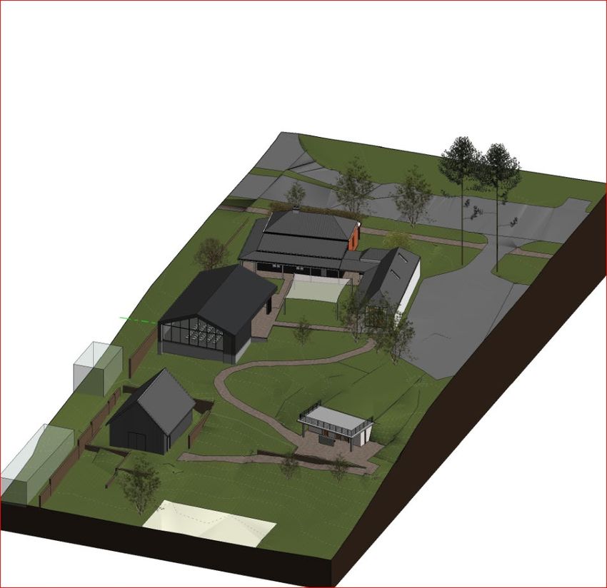
Ordinary Council Meeting Minutes                                                                                           3 March 2020

Order Of Business

1    Declaration of Opening/Announcement of Visitors........................................................... 4
2    Record of Attendance/Apologies/Leave of Absence (Previously Approved) .................. 4
3    Disclosure of Interests ........................................................................................................ 4
4    Response to Previous Public Questions Taken on Notice ............................................... 4
     Nil
5    Public Question Time .......................................................................................................... 5
6    Public Statement Time ........................................................................................................ 6
7    Applications for Leave of Absence .................................................................................... 6
8    Petitions/Deputations/Presentations .................................................................................. 6
9    Confirmation of Minutes of Previous Meetings ................................................................. 7
10   Announcement of Confidential Matters for which the Meeting may be Closed to
     the public.............................................................................................................................. 7
11   Business Not Dealt with From a Previous Meeting ........................................................... 7
     Nil
12   Reports of Committees ....................................................................................................... 8
     12.1        Lake Claremont Advisory Committee ....................................................................... 8
                 12.1.1       Minutes of the Lake Claremont Advisory Committee Meeting held on
                              13 February 2020 ........................................................................................ 8
13   Reports of the CEO .............................................................................................................. 9
     13.1        Liveability ................................................................................................................. 9
                 13.1.1       58-62 Bay View Terrace, Claremont - Modifications to Large Format
                              LED Signage ............................................................................................... 9
                 13.1.2       Lot 102 (256) Stirling Highway, Claremont - Reconsideration of 8-
                              Storey Mixed-Use Development ................................................................ 19
                 13.1.3       Freshwater Bay Museum Redevelopment Project - Findings of
                              Steering Group and Recommendations ..................................................... 31
14   Announcements by the Presiding Person ....................................................................... 69
15   Elected Members’ Motions of which Previous Notice has been Given .......................... 69
     Nil
16   New Business of an Urgent Nature Approved by the Presiding Person or by
     Decision of Meeting ........................................................................................................... 69
17   Confidential Matters for which the Meeting may be Closed to the Public ..................... 69
18   Future Meetings of Council ............................................................................................... 69
19   Declaration of Closure of Meeting .................................................................................... 69

                                                                                                                                      Page 3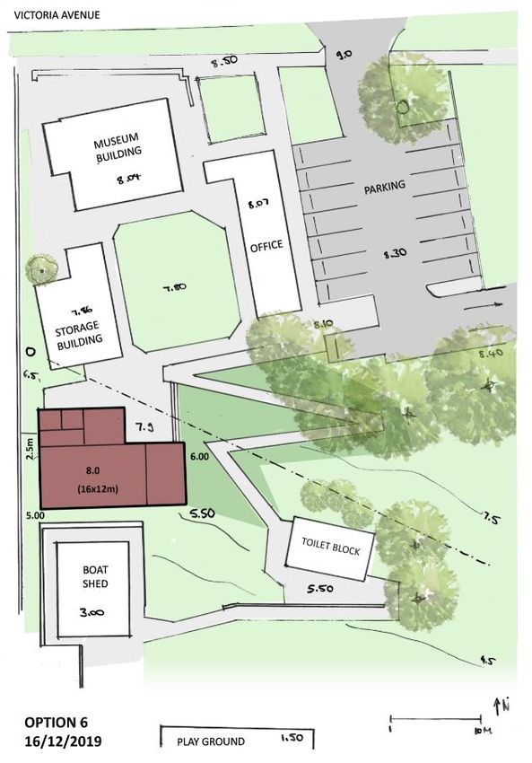
Ordinary Council Meeting Minutes                                                  3 March 2020

                     MINUTES OF TOWN OF CLAREMONT
                        ORDINARY COUNCIL MEETING
HELD AT THE TOWN OF CLAREMONT, CLAREMONT COUNCIL CHAMBERS, 308 STIRLING
                          HIGHWAY, CLAREMONT
                    ON TUESDAY, 3 MARCH 2020 AT 7.00PM

1       DECLARATION OF OPENING/ANNOUNCEMENT OF VISITORS

His worship the Mayor, welcomed members of the public, press, staff and Councillors and declared
the meeting open at 7.01pm.

2       RECORD OF ATTENDANCE/APOLOGIES/LEAVE OF ABSENCE (PREVIOUSLY
        APPROVED)

PRESENT:
Mayor Jock Barker
Deputy Mayor Cr Jill Goetze
Cr Peter Browne OAM, JP
Cr Sara Franklyn
Cr Bruce Haynes
Cr Paul Kelly
Cr Kate Main
Cr Annette Suann
Cr Peter Telford

IN ATTENDANCE:
Liz Ledger (Chief Executive Officer)
Andrew Smith (Director Infrastructure and Assets)
Bree Websdale (Director, Governance and People)
Cary Green (Director Corporate and Compliance)
David Vinicombe (Director Planning and Development)
Kerith Barbetti (Governance Officer)

25 members of the Public, 1 members of the Press

APOLOGIES:
Nil
LEAVE OF ABSENCE:

Cr Peter Edwards

3       DISCLOSURE OF INTERESTS

Nil

4       RESPONSE TO PREVIOUS PUBLIC QUESTIONS TAKEN ON NOTICE

Nil

                                                                                         Page 4
Ordinary Council Meeting Minutes                                                           3 March 2020

5        PUBLIC QUESTION TIME

Mr Paul Pell and Mrs Yvonne Pell of Unit 2, 6 John Street, Claremont
Re: Item 13.1.2 Lot 102 (256) Stirling Highway, Claremont – Reconsideration of 8 Storey
mixed-use development
Question 1:
I would ask the Council are the developers and Main Roads aware of the constant traffic snarls that
occur on a daily bases between Goldsworthy Road, John Street, Leura Avenue, Bayview Terrace
and Stirling Road?

Answer 1:
The Town cannot categorically answer this from the point of view of the developer or Main Roads,
but it is assumed that both parties would be aware of the traffic situation in the general locality of the
proposed development.

Question 2:
How can they justify adding to the existing traffic difficulties by constructing 5 commercial and 53
residential apartments in this area bordering Stirling highway?

Answer 2:
The land is currently zoned Highway under LPS4 and Urban/Primary Regional Road under the
MRS. The existing commercial development has been vacant for a number of years. The Town’s
Housing Strategy (2013) and Stirling Highway Local Development Plan (2016) promote higher
density residential development along the Highway initially as a measure for the Town to meet its
WAPC density targets, but now more-so to promote long-term strategies for sustainable infill
development contained along the Highway frontage and avoid its further encroachment into the
adjacent established heritage and tree-lined single residential streetscapes in a similar manner to
that which has been controversially applied to similar land in the City of Nedlands.

Question 3:
Both John street and Bernard street were not designed to take the extra volume of traffic that would
result if this development was allowed to proceed. This is a great concern to residents of both these
streets. What provisions have been made to cope with the extra volumes of traffic using these
streets, and if so, what are these provisions and how would the existing residents be affected?

Answer 3:
The crossover to Stirling Highway will serve as the main access and egress point to the proposed
development, with secondary traffic movements through the rear Right of Way. If the development
is approved and traffic movement in the local streets become problematic, the Town will undertake
traffic counts and investigate the issues before looking at measures to address the situation. These
measures may include the provision of parking restrictions, traffic management devices such as slow
points and intersection modifications to divert/slow traffic movement in the locality.

Mr Glen Ticehurst on behalf of Ms Bettina Jacoby of Unit 1, 6 John Street, Claremont
Re: Item 13.1.2 Lot 102 (256) Stirling Highway, Claremont – Reconsideration of 8 Storey
mixed-use development
Question:
Why can’t restricted access to the R.O.W. not be included in the set of conditions being proposed to
the JDAP by the Town’s Planning Officers?

Answer:
As with the previous answer, the crossover to Stirling Highway will serve as the main access and
egress point to the proposed development, with secondary traffic movements through the rear Right
of Way. The secondary access through the ROW will provide capacity for alternative traffic
movements which are not accommodated directly to or from the site from the Highway, which may

                                                                                                   Page 5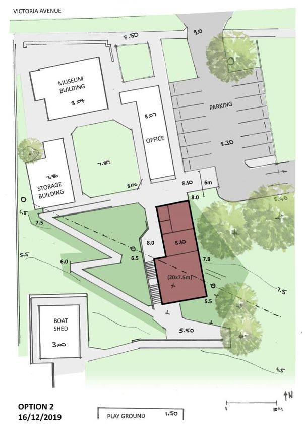
Ordinary Council Meeting Minutes                                                           3 March 2020

alter over time. It is noted that at this point of time, a median island is not proposed to be constructed
in Stirling Highway, however this is a requested Main Roads condition which the Town does not
support as this point, notwithstanding that when Main Roads reconstructs the Highway with median
islands and provides limited access to side streets, this situation will change. The Town will also
raise additional comments on the left in and left out requirement from Main Roads in the Responsible
Officer’s report to the JDAP.

6        PUBLIC STATEMENT TIME

Mrs Delia Craig of 3/6 John Street, Claremont
Re: Item 13.1.2 Lot 102 (256) Stirling Highway, Claremont – Reconsideration of 8 Storey
mixed-use development.
Mrs Craig submitted a statement outlining concerns regarding the proposed development application
though elected not to read the statement aloud.

Dr Susan Stoney of 15 Bernard Street, Claremont
Re: Item 13.1.2 Lot 102 (256) Stirling Highway, Claremont – Reconsideration of 8 Storey
mixed-use development.
Dr Stoney spoke of concerns regarding the proposed development application.

Mr Chris and Mrs Talitha Marco of 262-264 Stirling Highway, Claremont
Re: Item 13.1.2 Lot 102 (256) Stirling Highway, Claremont – Reconsideration of 8 Storey
mixed-use development.
Mr and Mrs Marco submitted a statement outlining concerns regarding the proposed development
application though elected not to read the statement aloud.

Dr Ricki Hewitt of 28 Goldsmith Road, Claremont
Re: Item 13.1.3 Freshwater Bay Museum Redevelopment Project - Findings of Steering Group
and Recommendations.
Dr Hewitt spoke in favour of the recommendation outlined in the proposal though requested further
consideration be given to the proposed storage facilities.

Dr Peter Tannock on behalf of Mr Tim Humphry of 68A Victoria Avenue, Claremont
Re: Item 13.1.3 Freshwater Bay Museum Redevelopment Project - Findings of Steering Group
and Recommendations.
Dr Peter Tannock on behalf of Mr Tim Humphry spoke in favour of the proposed development
application.

7        APPLICATIONS FOR LEAVE OF ABSENCE

Nil

8        PETITIONS/DEPUTATIONS/PRESENTATIONS

Nil

                                                                                                   Page 6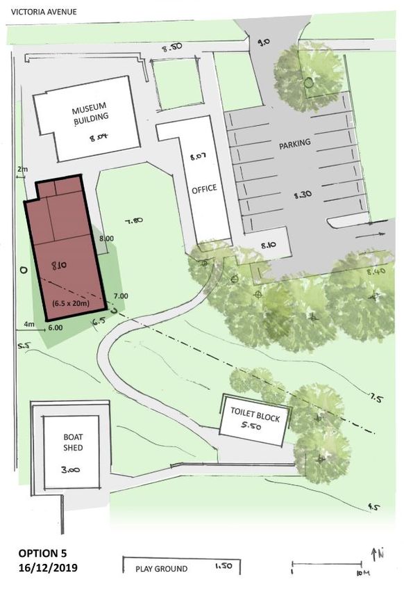
Ordinary Council Meeting Minutes                                              3 March 2020

9       CONFIRMATION OF MINUTES OF PREVIOUS MEETINGS

RESOLUTION 012/20
Moved: Cr Annette Suann
Seconded: Cr Peter Browne OAM, JP
That the minutes of the Ordinary Meeting of Council held on 18 February 2020 be confirmed.
                                                                   CARRIED NO DISSENT

10      ANNOUNCEMENT OF CONFIDENTIAL MATTERS FOR WHICH THE MEETING
        MAY BE CLOSED TO THE PUBLIC

Nil

11      BUSINESS NOT DEALT WITH FROM A PREVIOUS MEETING

Nil

                                                                                     Page 7
Ordinary Council Meeting Minutes                                             3 March 2020

12        REPORTS OF COMMITTEES

12.1      LAKE CLAREMONT ADVISORY COMMITTEE
12.1.1    MINUTES OF THE LAKE CLAREMONT ADVISORY COMMITTEE MEETING HELD ON
          13 FEBRUARY 2020
File Number:       GOV/00051-03, D-20-08166
Author:            Isabelle Cadman, Administration Officer Infrastructure
Authoriser:        Liz Ledger, Chief Executive Officer
Attachments:       1.    Lake Claremont Advisory Committee 2020 Feb 13 Minutes

RESOLUTION 013/20
Moved: Cr Bruce Haynes
Seconded: Cr Sara Franklyn
1.     That the Minutes of the Lake Claremont Advisory Committee Meeting held on 13
       February 2020 be received and the recommendations therein be adopted.
                                                                   CARRIED NO DISSENT

Item 12.1.1                                                                           Page 8
Ordinary Council Meeting Minutes                                                       3 March 2020

13         REPORTS OF THE CEO

13.1       LIVEABILITY
13.1.1     58-62 BAY VIEW TERRACE, CLAREMONT - MODIFICATIONS TO LARGE FORMAT
           LED SIGNAGE
File Number:         01PEA/20/5764, D-20-04261
Attachments:         1.    Location Map
                     2.    Photograph
                     3.    WAPC/JDAP Approved Plans - Confidential
                     4.    Plans for Development Application & Sign Licence Application -
                           Confidential
Author:              Lisa Previti, Manager Planning and Building
                     David Vinicombe, Director Planning and Development
Authoriser:          Liz Ledger, Chief Executive Officer
Proposed Meeting Date:        3 March 2020
Date Prepared:                21 February 2020
DA No.:                       DA2002.00004
60/90 Days Due Date:          11 March 2020
Property Owner:               Spyglass Pacific Pty Ltd
Applicant:                    Pinnacle Planning
Lot No.:                      501
Area of Lot:                  835m2
Zoning:                       Town Centre and Primary Regional Road Reservation

Enabling Legislation:         Planning and Development Act 2005 (PD Act)
                              Local Planning Scheme No. 3 (LPS3)
                              Local Law Relating to Signs (Signage LL)

SUMMARY
•      Application for Development Approval (to be determined by the Western Australian Planning
       Commission - WAPC) and following Sign Licence (to be determined by the Town, if the
       Development Application is approved by the WAPC) received for modifications to the approved
       Sign A large format LED screen at 58-63 Bay View Terrace.
•      The history relating to the development on this site (and the signage proposed) is encapsulated
       in the attached reports to Council on 5 February 2019 and 17 September 2019.
•      Development Applications (inclusive of the signage proposals) have been granted approval by
       the Metro West Joint Development Assessment Panel (JDAP) on behalf of the WAPC and
       Council as the site is partially contained in the Metropolitan Region Scheme (MRS) Primary
       Regional Road (PRR) reservation and land controlled under Local Planning Scheme No. 3
       (LPS3) granted 15 February 2019. The signage component of the applications was not
       approved under the LPS3 application as it was exempt from requiring Development Approval
       under the deemed provisions of the Planning and Development (Local Planning Schemes)
       Regulations 2015 (LPS Regs).

Item 13.1.1                                                                                    Page 9
Ordinary Council Meeting Minutes 3 March 2020
• An application for the Sign Licences was received for two large format illuminated LED signs
on 22 March 2019. The signage proposals consisted of two Illuminated Horizontal Signs (Sign
A – 9.148m (corrected to 8.357m consistent with the plans lodged for WAPC approval) x 3m
curved screen facing intersection of Bay View Terrace and Stirling Highway, and Sign B -
4.85m x 4.56m screen facing east adjacent Stirling Highway). Council resolved to refuse the
applications for Sign Licences on 2 July 2019 (Sign A) and on 16 July 2019 (Sign B) for non-
compliance with the Town’s Local Law Relating to Signs (Signage LL).
• A revised application for the two signs was lodged on 5 September 2019. Sign A was revised
to 8.235m wide consistent with the WAPC Development Approval plans. The revised
application provided additional justification for the proposed signs by addressing a range of
separate and discrete, but interrelated requirements. Significantly, the applications provided
clarity on the remnant amenity and community impact concerns to assist assessment under
the Signage LL requirements. The Sign Licences were subsequently approved by Council on
17 September 2019 subject to conditions.
• As a result of a drafting error during the State Administrative Tribunal (SAT) process (to which
the Town was not privy as the decision maker was the WAPC) the intended size of Sign A was
not accurately reflected on the WAPC or the subsequently approved Sign Licence plans. The
current application is to increase the ‘Active’ width of the approved Sign A from 8.235m to
9.144m (an increase in width of 0.909m), to be consistent with the intent of the SAT outcome.
It is noted that the height of the sign is to be slightly reduced from 3m to 2.926m, resulting in
an overall signage area increase from 24.705m2 to 26.755m2 (increase of 2.05m2).
• The increased width and reduction in height of the sign is minor in consideration of its overall
size, and is considered consistent with the requirements of the Town’s Local Law Relating to
Signs (Signage LL) for changes (variations) to be assessed against its provisions contained in
cl.4 and 20.
• Application is recommended for approval to the WAPC, subject to relevant conditions.
• Should the WAPC determine to grant Development Approval, it is recommended that the Sign
Licence be issued accordingly.
PURPOSE
For Council to consider the Development Application (for recommendation to the WAPC) and
application for a Sign Licence for a modification to the approved Illuminated Horizontal Sign
(approved 8.235m x 3m curved screen facing Stirling Highway and Bay View Terrace intersection)
The proposal is to increase the ‘Active’ width of the approved Sign A from 8.235m to 9.144m (an
increase in width of 0.909m), to be consistent with the intent of the SAT outcome. It is noted that
the ‘Active’ height of the sign is to be slightly reduced from 3m to 2.926m, resulting in an overall
‘Active’ signage area increase from 24.705m2 to 26.755m2 (increase of 2.05m2).
The sign proposes to vary the Town’s Local Law – Relating to Signs (Signage LL) for the following
reasons:
1. The ‘Illuminated sign’ is capable of emitting, and is intended to emit, light at an intensity
substantially greater than 25 lumens as required by the Signage LL and consequently does
not comply with cl.21.3 of the Signage LL.
2. The ‘Horizontal sign’ will have a superficial area greater than 2m2 and consequently does not
comply with cl.26.1 of the Signage LL.
3. The ‘Horizontal sign’ is to be located more than 9m above the ground and will have a height
(i.e. a vertical dimension) greater than 900mm. Consequently, it does not comply with cl.26.2
of the Signage LL.
BACKGROUND
1. On 24 June 2016, an application for Development Approval was lodged in respect of Lot 510
(58-62) Bay View Terrace, Claremont. It involved:
Item 13.1.1 Page 10Ordinary Council Meeting Minutes 3 March 2020
a) Refurbishing the existing two storey building on the land. The building is included on the
Town's Heritage List.
b) The addition of a new third storey office; and
c) Two illuminated signs attached to the new third storey. One of the Illuminated Horizontal
Signs wraps around the south-western corner of the development (south-western sign)
and the other is located on the eastern façade of the development (eastern sign). A
0.67m portion of the face of the eastern sign extended beyond the MRS reservation and
into the part of the site which is currently un-zoned under LPS3. This land was the
subject of Amendment No 137 to LPS3 and has now been granted Ministerial approval
and gazetted.
2. On 29 September 2016, the JDAP granted development approval under the MRS excluding
the signs.
3. On 15 October 2018, the JDAP granted approval under LPS3 for the development but
excluded the signs. The minutes of the JDAP meeting include condition 2 which states:
“The illuminated Large Format Digital Signs are not approved as the signs are an unlisted
use (third party advertising) which is prohibited by clause 14(5) of Local Planning
Scheme No. 3. The Large Format Digital Signs would also have a detrimental effect on
the heritage values of the building and the amenity of the locality.”
4. Following a State Administrative Tribunal (SAT) review, the JDAP, in accordance with section
31 of the State Administrative Tribunal Act 2004 (SAT Act) reapproved the proposed
development inclusive of the proposed signage on 8 June 2018.
5. On 17 December 2018, amended plans were lodged by the applicant. The effect of those
plans was that the signs were to be located wholly inside the MRS reservation.
6. On 15 February 2019 the JDAP granted approval under the MRS for the development inclusive
of the signs with an amended condition 14 which stated:
“All LED sign content shall be in accordance with the Updated Sign Content Management
Plan, dated April 2017.”
The Sign Content Management Plan requires:
1. All content for advertising at the Property will be managed by the Operator, as set out in
the management plan, and subject to the terms of any planning approval.
2. The content of advertising at the Property is restricted to the following:
a. Tenants and businesses located within the Claremont Town Centre Precinct;
b. Products and services of tenants and businesses located within the Claremont Town
Centre Precinct;
c. Road safety messages;
d. Local Town of Claremont event and tourism messages;
e. Main Roads Western Australia/Department of Transport advanced warning/traffic
messages;
f. Educational establishments located within the Town of Claremont
3. Notwithstanding Clause 2, Signage must not contact any offensive, discriminatory, or
distasteful messages, in accordance with the requirements and guidelines published by
the Outdoor Media Association of Australia, to the satisfaction of the Chief Executive
Officer of the Town of Claremont.
4. Given the proximity of the property to the Town of Claremont War Memorial, all electronic
advertising will be switched off on ANZAC Day and Remembrance Day.
5. Terms referred to above are defined below:
Property means 58 Bay View Terrace, Claremont.
Item 13.1.1 Page 11Ordinary Council Meeting Minutes 3 March 2020
Claremont Town Centre Precinct means the land bound by Stirling Road, Stirling
Highway, Leura Avenue and Gugeri Street Claremont.
Operator means the person or persons who are responsible from time to time for the
management of advertising at the Property.
The application includes a revised Content Management Plan which includes switching off the
signs on when the flags are flying at half-mast.
7. On 15 February 2019 the JDAP also granted approval for the development under LPS3,
however deleted condition 7 (which proposed to refuse the signage) on consideration of their
legal advice that LPS3 approval is not required as the signs are located in the Primary Regional
Road reservation under the MRS and on the basis that the condition was inappropriate as it
sought to restrict development in the reservation inconsistent with the existing MRS approval.
8. A Building Permit consistent with the Development Approvals was lodged on 7 March 2019
and subsequently issued on 22 March 2019.
9. On 22 March 2019, two applications for the Sign Licence were received from the applicant.
The application was reviewed on 16 April 2019 and included:
Sign A is a 3m (h) x 9.148m (corrected to 8.357m to be consistent with the submitted plans
lodged for WAPC approval) (w) sign, described as “Hoarding with steel cabinets and steel
supports”. The plan stated “illuminated screen 10.5% of Façade” and showed a curved screen
facing intersection of Bay View Terrace and Stirling Highway.
10. The Sign Licences were considered by Council at its meeting held 17 September 2019 and
were subsequently approved in consideration of an assessment under cl.4 and cl.20 of the
Signage LL.
The following table outlines key dates regarding this proposal:
Date Item/Outcome
10 January 2020 Application for Development Approval received by Council.
15 January 2020 Application undergoes internal DCU assessment.
25 February 2020 Application for Sign Licence received by Council.
24 January 2020 Report prepared for Council.
PAST RESOLUTIONS
Ordinary Council Meeting 2 July 2019, Resolution No. 82/19:
THAT Council refuse to grant Sign Licence for proposed Sign A at 58-62 Bay View Terrace,
Claremont for the following reasons:
1. The proposed sign does not satisfy the philosophy or objectives underlining the Town of
Claremont Local Law – Relating to Signs as it will have a detrimental impact on the special
character and ambience of the Town of Claremont, specifically its heritage character,
streetscapes and areas of cultural significance including the property itself with its southern
entrance to the Bay View Terrace Heritage Precinct and adjacent State Heritage Listed
Claremont Heritage Area and associated Claremont War Memorial.
2. The sign does not satisfy the Design Principles of the Town of Claremont Local Law – Relating
to Signs as the design, lighting intensity, size and location of the signage is not sympathetic or
harmonious with the existing heritage building on which it is to be located, or the Bay View
Terrace Heritage Precinct, the adjacent State Heritage Listed Claremont Heritage Area and
associated Claremont War Memorial, or the future amenity of planned residential development
in the Town Centre at this location.
Ordinary Council Meeting 2 July 2019, Resolution 126/19:
THAT Council approve a variation to the Illuminated Horizontal Sign requirements pursuant to
clauses 4 and 20 of the Town of Claremont Local Law – Relating to Signs with respect to proposed
Item 13.1.1 Page 12Ordinary Council Meeting Minutes 3 March 2020
Sign A and Sign B at 58-62 Bay View Terrace, Claremont for reasons outlined in the Officer’s report
and approve both Sign Licence applications subject to the following conditions:
1. The signage is to be in accordance with Main Roads Guide to Roadside advertising, including
a lighting assessment, and annual lighting audit at the applicant’s cost.
2. Prior to the use of the signs for commercial advertising, the applicant is to provide a Lighting
Management Plan to the satisfaction of the Town of Claremont which ameliorates lighting
and luminance levels relative to ambient light conditions, inclusive of adjustments in lighting
intensity to address overcast or rainfall daytime conditions and improve amenity and safety
outcomes.
3. The applicant providing one advertisement per rotation for community based messages
promoting local tourism, community events and community safety managed by the Town of
Claremont.
4. Compliance with the Revised Content Management Plan dated 10 September 2019.
5. No commercial advertising is to occur on the two days leading up to ANZAC Day and during
this period the signs are to contain messages relating to ANZAC Day and the ANZAC spirit
only to the satisfaction of the Town of Claremont.
Statutory Considerations
Western Australian Planning Commission Referral
As the development is located wholly within the MRS Primary Regional Road reservation the
application has been referred to the WAPC for determination.
Main Roads Western Australia Referral
As the development is located wholly within the MRS Primary Regional Road reservation the
application was referred to MRWA for comment which have advised non objection to the proposed
modification to the sign.
Local Law Relating to Signs
Pursuant to cl.4 of the Signage LL:
• “Any changes to the Local Law Relating to Signs must be implemented in such a way as to
preserve and enhance the amenity and character of the Town” (cl.4.1).
• “No signage should detrimentally impact upon the special character and ambience of the Town
of Claremont, nor detract from the visual beauty of its suburbs, streetscapes, town centre and
recreational and cultural areas” (cl.4.1.1).
• “Signs should blend with the natural and/or built environment” (cl.4.1.5).
Clause 20.1 of the Signage LL requires that the signs are erected and maintained or proposed to be
erected “in design, colour and location be sympathetic and harmonious with the surrounding street,
way, footpath, public place or private property and environment and the building or structure to which
it is attached or affixed”.
Heritage
The property is included on the Town's Heritage List. As such the application was referred to the
Town’s Heritage Officer who advised as the sign is already approved there will be little change to
the existing heritage impact.
COMMUNICATION / CONSULTATION
The original application was advertised in accordance with Council Policy LG525.
Thirty six adjacent property owners and tenants were consulted and five objections were received in
relation to the signage.
Item 13.1.1 Page 13Ordinary Council Meeting Minutes 3 March 2020
The current application was not re-advertised as it is not substantially different from the approved
sign.
DISCUSSION
Description
As a result of a multitude of drafting errors in the way in which dimensions of Sign A were shown on
plans, the application proposes a minor increase in the size from 8.235m x 3m to an ‘Active’ width
of 9.144m (an increase in width of 0.909m), to be consistent with the intent of the WAPC SAT
outcome which the Town was not privy.. It is noted that the height of the sign is to be slightly reduced
from 3m to 2.926m, resulting in an overall signage area increase from 24.705m2 to 26.755m2
(increase of 2.05m2).
Compliance
With regard to the above Signage LL provisions (cl.4 and cl.20), the following comments are
considered relevant in determining the applications for the Development Application and subsequent
Sign License, noting that Council has to a degree an obligation to be consistent with its previous
decision to approve a variation to the Signage LL given the minor 0.915m increase in width of the
sign:
• The sign has previously been granted Development Approval by the JDAP on behalf of the
WAPC. It is noted that the current Development Approval granted by JDAP for the WAPC
included a conditions from the 2 June 2017 approval requiring:
“LED Signage
11 In accordance with the Transcore Road Safety Assessment Report dated August 2016,
and updated by way of letter dated 3 April 2017:
11.1 Any illumination of LED signage must be of a low level not exceeding:
11.1.1 Daytime - 6000 cd/m2
11.1.2 Dawn/Dusk - 600 cd/m2
11.1.3 Night - 300 cd/m2.
11.2 All LED signage shall not flash, pulsate or chase.
11.3 All LED signage shall display only single, 'self-contained' messages.
Messages in the form of a sequential series of related messages shall not be
permitted.
11.4 All LED signage messages and static images shall have a 'dwell' duration of
not less than 60 seconds.
11.5 Transitional effects (such as fly-in, fade-out, and scrolling) shall not be
permitted on the LED signage.
12 The LED signage is only permitted to display advertising content between the hours of
5am and 11pm daily, on all days of the year, except ANZAC day (later modified at JDAP
on 15 February 2019 to include Remembrance Day and also now to include whenever
the flag is flying at half-mast as detailed in the revised Content Management Plan) when
no advertising is permitted.
13 When the LED advertising signs are in operation at night:
13.1 The external façade of the building shall be externally lit; and
13.2 The internal lights to the third floor addition shall be internally lit;
to the specification of the local government and the satisfaction of the Western
Australian Planning Commission.”
Item 13.1.1 Page 14Ordinary Council Meeting Minutes 3 March 2020
• The JDAP decision on behalf of the WAPC took into account and endorsed aspects of the
following reports submitted through the SAT proceedings to address amenity and traffic safety
considerations:
• A Lighting Impact Assessment prepared by Electrolight Australia Pty Ltd which
addresses the lighting intensity and associated amenity impacts of the proposed signs
and concludes:
“The proposed illuminated signage complies with all relevant requirements of AS 4282-
1997 Control of Obtrusive Effects of Outdoor Lighting. In complying with these
requirements, the proposed signage will not result in unacceptable glare nor will it
adversely impact the safety of pedestrians, residents or vehicular traffic. The proposed
signage will also not cause any reduction in visual amenity to nearby residences or
accommodation.”
• A Visual Impact Assessment prepared by EPCAD Pty Ltd which concludes:
“The proposed illuminated signage is also in keeping with the surroundings and is not
highly visible when viewed in the wider urban context. The level of visual impact is likely
to be very minor especially given the context of the developing urban setting and the
limited viewing ability from heritage places.
Key observations detailed in this report, which support this statement are;
• The location of the proposal ensures that it will not be prominent in the landscape and
will not adversely affect the landscape character or qualities of the local area;
• The proposed… illuminated advertising signage is not out of place with the general
land use and urban character of the local area;
• The proposals built form and aesthetic will be designed sympathetically to retain
existing heritage value;
• The proposal would only be visible fully from a small section of the adjacent roads
and public open spaces;
• The proposal would only be visible from a small number of private residences situated
at distance from the site;
• The proposal rarely breaks the skyline created by the existing topography and
surrounding built form.”
• Heritage impact reports prepared by TPG Place Match and Griffiths Architects which conclude:
“The introduction of LED signage to the proposed upper façade of No 58-62 Bay View Terrace,
Claremont, would have a minimal impact on the heritage values of the Bay View Terrace
Commercial Heritage Precinct in which it is located, provided that (as proposed) the signage
is static in nature and the content is related to the offerings and events in the locality. This is
because:
• Commercial signage is an integral component of a commercial heritage precinct and
the proposed content is commensurate with historical signage;
• The potential impact of the signage is limited to views of Sign 1 and those views are
restricted to a localised portion at the southern end of the Precinct;
• The restriction of the LED to static display (rather then (sic) moving) will limit visual
distraction from appreciation of the Precinct at its southern end; and
• It is part of the commercial evolution of the Precinct that is recognised in its heritage
listing and provides potential opportunities for increased public appreciation of the
Precinct.” (TPG Place Match)
“As this impact statement demonstrates, there is no significant impact on the heritage values
of (sic) National Bank (fmr) by addition of a third storey.” (Griffiths Architects)
Item 13.1.1 Page 15Ordinary Council Meeting Minutes 3 March 2020
• The proposed sign is to be located on a third storey addition to the former National Bank which
is a significant Federation-era building in the Bay View Terrace Heritage Precinct, with
demonstrable special character, aesthetic, social and historic values.
• The building is included on the Town's Heritage List and is located at the southern end of the
Bay View Terrace Heritage Precinct.
• The building is located opposite the State Listed Claremont Heritage Area which contains the
Town’s War Memorial. The War Memorial is of cultural significance to the Town. The central
and eastern northern boundary is lined with significant trees.
• Bay View Terrace is the commercial heart of the Town of Claremont, and historically its most
important street.
• Despite not meeting the size and luminosity requirement of the Signage LL, the revised
proposal represents a minor increase in width and takes into consideration the previously
account the new considerations which provide for significantly improved amenity and
community benefit outcomes: The improvements include:
o Specifying the terms of local community based messages relating to Town of
Claremont events (as required by the Content Management Plan – required as a
condition of the JDAP WAPC approval). This includes the provision for one Town of
Claremont community based advertisement per rotation that can be used for local
tourism and community events, safety and community messages and the like. This
will assist in reducing signage clutter in the Town by providing a central display
medium, and further contributing to and enhancing the prominence and viability of the
local community.
o Providing for a no commercial advertising during the two day lead-up to ANZAC Day
and replacing advertising on these days with ANZAC related messaging which
respects the importance of the War Memorial, contributes to its sense of place,
highlights the ANZAC spirit and raises awareness for the ANZAC ceremony in the
immediate locality.
o Confirmation that the signage will be in accordance with Main Roads Guide to
Roadside advertising, including a lighting assessment, and annual lighting audit (at
the applicant’s cost).
o Agreement to provision of a Lighting Management to further assist with any lighting
and luminance level considerations applicable to the property, which will deal with the
ability to vary luminance levels according to ambient light conditions.
The Lighting Management Plan will take into account the lighting levels set by
condition 11.1 of the JDAP approval stated above, but also provide capacity to
automatically reduce the lighting intensity during daytime overcast and rainfall events
where ambient light conditions are darker in order to reduce the potential amenity and
safety impacts of the signs.
• It is considered that the sign maintains the improved respect for the special character and
ambience of the building and the Bay View Terrace Heritage Precinct streetscape together
with the adjacent Claremont Park and associated War Memorial as:
o The revisions proposed in the current application to further address the amenity and
community impacts by significantly improving community activation outcomes.
o The relationship between the site and the War Memorial (inclusive an improved
respectful relationship between advertising arrangements relative to ANZAC Day,
Remembrance Day and when the War Memorial flag is being flown at half-mast).
o The commitment to the provision of a Lighting Management Plan to further reduce
amenity impacts and traffic safety during poor daylight ambient conditions.
Item 13.1.1 Page 16Ordinary Council Meeting Minutes 3 March 2020
• Over time proposed Sign A will blend with the natural and/or built environment and be less
visually dominant and not detract from the visual appreciation and beauty of the place. It is
considered the additional length of the sign will not detract any further from the visual
appreciation nor dominate any further than the approved sign.
In summary, it is considered that the conditions proposed will improve the relationship between the
Town Centre, Claremont Park (and its associated War Memorial) and will deliver improved local
community outcomes for the Town. Accordingly a variation to the Signage LL and approval of the
modifications to the sign is recommended.
FINANCIAL AND STAFF IMPLICATIONS
N/A
POLICY AND STATUTORY IMPLICATIONS
N/A
STRATEGIC COMMUNITY PLAN
Liveability
We are an accessible community with well-maintained and managed assets. Our heritage is
preserved for the enjoyment of the community.
• Balance the Town's historical character with complementary, well designed development.
URGENCY
The WAPC has a statutory time frame of 60 days in which to determine the application for
Development Approval. It is noted there is no statutory time frame for the issue of a Sign Licence
under the Signage LL.
CONCLUSION
Based on the above, it is recommended that modifications to Sign A be approved by the WAPC for
the reasons set out in the Officer’s recommendation and the WAPC be advised accordingly. Should
the WAPC determine to approve the application, it is recommended the Sign Licence be approved
subject to conditions.
VOTING REQUIREMENTS
Simple majority decision of Council required.
RESOLUTION 014/20
Moved: Deputy Mayor Cr Jill Goetze
Seconded: Cr Kate Main
THAT Council
1. Approve a variation to the Illuminated Horizontal Sign requirements pursuant to
clauses 4 and 20 of the Town of Claremont Local Law Relating to Signs with respect
to modifications to Sign A at 58-62 Bay View Terrace, Claremont for reasons outlined
in the Officer’s report and recommend to the Western Australian Planning
Commission that the application be approved for reasons outlined in the Officer’s
report, subject to same conditions as the current approval.
2. Should the Western Australian Planning Commission grant Development Approval
approve the Sign Licence application subject to the following conditions:
a. The signage is to be in accordance with Main Roads Guide to Roadside
advertising, including a lighting assessment, and annual lighting audit at the
applicant’s cost.
Item 13.1.1 Page 17Ordinary Council Meeting Minutes 3 March 2020
b. Prior to the use of the signs for commercial advertising, the applicant is to provide
a Lighting Management Plan to the satisfaction of the Town of Claremont which
ameliorates lighting and luminance levels relative to ambient light conditions,
inclusive of adjustments in lighting intensity to address overcast or rainfall
daytime conditions and improve amenity and safety outcomes.
c. The applicant providing one advertisement per rotation for community based
messages promoting local tourism, community events and community safety
managed by the Town of Claremont.
d. Compliance with the Revised Content Management Plan dated 10 September 2019.
e. No commercial advertising is to occur on the two days leading up to ANZAC Day
and during this period the signs are to contain messages relating to ANZAC Day
and the ANZAC spirit only to the satisfaction of the Town of Claremont.
For: Mayor Jock Barker, Cr Jill Goetze, Cr Peter Browne OAM, JP, Cr Sara Franklyn,
Cr Kate Main, Cr Annette Suann, Cr Peter Telford
Against: Cr Bruce Haynes, Cr Paul Kelly
CARRIED 7/2
Item 13.1.1 Page 18Ordinary Council Meeting Minutes 3 March 2020
13.1.2 LOT 102 (256) STIRLING HIGHWAY, CLAREMONT - RECONSIDERATION OF 8-
STOREY MIXED-USE DEVELOPMENT
File Number: 01PEA/19/3660, D-20-05213
Attachments: 1. Location & Submission Map
2. Photograph
3. Applicant's Documentation
4. Table of Submissions
5. Applicant's Submission Response
6. Plans - Confidential
7. Submissions - Confidential
8. Responsible Authority Report - 13 January 2020
9. Additional Plans - Vehicle Turning Template
10. Annotated Cross Section
11. Referral Agency Responses
Author: Josh Wilson, Urban Planner
Lisa Previti, Manager Planning and Building
David Vinicombe, Director Planning and Development
Authoriser: Liz Ledger, Chief Executive Officer
Proposed Meeting Date: 3 March 2020
Date Prepared: 10 February 2020
DA No.: DA2019.00078
60/90 Days Due Date: 4 March 2020
Property Owner: Zena Nominees Pty Ltd
Applicant: Element, Optimus Prime Equity
Lot No.: 102
Area of Lot: 2,038m2
Zoning: Highway, unzoned, MRS Primary Regional Road Reserve
Enabling Legislation: Planning and Development Act 2005 (PD Act)
Planning and Development Act (Development Assessment
Panels) Regulations 2011 (DAP Regs)
Planning and Development Act (Local Planning Schemes)
Regulations 2015 (LPS Regs)
Local Planning Scheme No. 3 (LPS3)
State Planning Policy 7.3 Residential Design Codes Volume 2 -
Apartments (RDC Vol. 2 Apartments)
Stirling Highway Local Development Plan (SHLDP)
SUMMARY
• Application for an 8-storey mixed-use development was considered by Council on 17
December 2019. Council supported a recommendation in the Responsible Authority Report
(RAR) to the Metro West Joint Development Assessment Panel (JDAP) that the application be
refused.
Item 13.1.2 Page 19Ordinary Council Meeting Minutes 3 March 2020
• Proposal was considered by the JDAP on 13 January. The JDAP deferred the application for
60 days to provide the applicant with an opportunity to resolve issues raised by Main Roads
WA (MRWA).
• Applicant has submitted additional information and MRWA is now supportive of the vehicle
access arrangements.
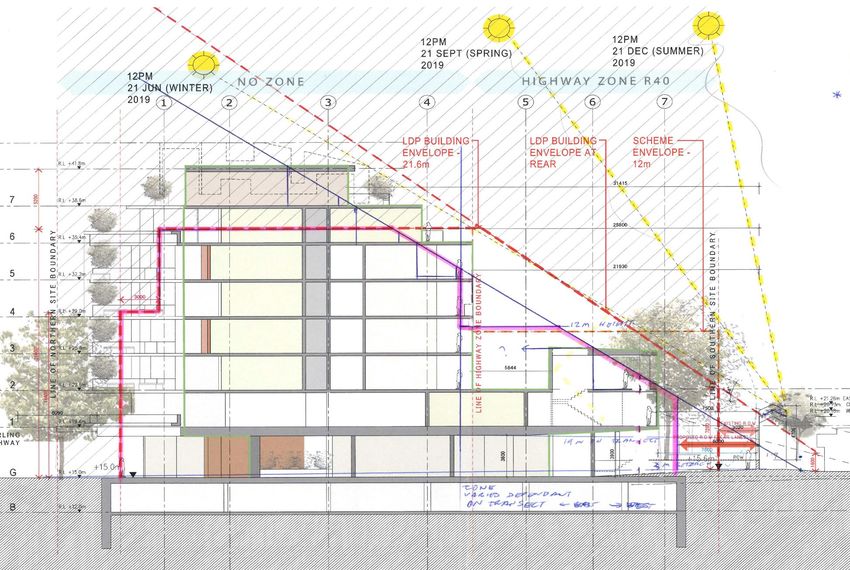
• Questions were raised during the JDAP meeting in regards to the building height and impacts
of the additional height on overshadowing of the residential properties to the rear. It was noted
following the meeting that there were some inaccuracies in the plans relative to the cross-
sectional representation of the building envelope set by the Stirling Highway Local
Development Plan (SHLDP) and Local Planning Scheme No. 3 (LPS3), which result in a
greater impact than discussed at the meeting.
• The proposed cross-sectional building envelop provides for a height of 6 stories in the entire
Metropolitan Region Scheme (MRS) ‘Urban’ zone, which is incorrect as the rear portion of the
height limit is to comply with the State Planning Policy 7.3 Residential Design Codes Volume
2 - Apartments (RDC Vol. 2 Apartments). In addition, the 12m height restriction in the LPS3
‘Highway’ zone is similarly to be restricted by consideration of adverse effects on the amenity
of adjoining residents.
• When these requirements are taken into consideration, the impacts of the two additional
proposed storeys are considerable on the adjoining residential property owners.
• The RAR maintains its previous objection to the proposed development, however given MRWA
now supports the proposal, the JDAP must either; not adopt the Town’s recommendation for
refusal in the RAR and accordingly approve the development consistent with the MRWA
recommendation, or alternatively, if the JDAP concludes on the basis of considering all relevant
matters applying to this application that the application should be refused consistent with the
Town’s RAR, it must refer the proposal to the Western Australian Planning Authority (WAPC)
for its RAR for recommendation to the JDAP, as the Town would no longer be the applicable
responsible authority for the JDAP determination.
PURPOSE
For Council to:
(i) Consider the officer recommendation; and
(ii) Be informed that the application has been referred to the Joint Development Assessment Panel
(JDAP) for its determination in accordance with the Planning and Development (Development
Assessment Panel) Regulations 2011 (DAP Regs).
BACKGROUND
The following table outlines key dates regarding this proposal:
Date Item/Outcome
11 July 2019 Application for Development Approval received by Council.
17 December 2019 Council recommends application be refused.
13 January 2019 Metro West JDAP defers decision to allow Main Roads WA issues
to be resolved.
17 February 2020 Revised plans received.
19 February 2020 Revised comments received from MRWA.
19 February 2020 Report prepared for Council.
See previous Council report for key dates prior to 17 December 2019)
PAST RESOLUTIONS
This application was previously considered by Council on 17 December 2019, where it was resolved
to:
Item 13.1.2 Page 20Ordinary Council Meeting Minutes 3 March 2020
“1. Support the Officer recommendation to the Metro West Joint Development Assessment Panel
that Development Approval be refused for the development of an eight storey mixed use
development at Lot 102 (256) Stirling Highway, Claremont.
2. Authorise the Director Planning and Development to forward a report on the application to the
Metro West Joint Development Assessment Panel.”
AMENDMENT RESOLUTION 200/19
“That the administration check if there is a statutory requirement for there to be an alternative
recommendation included in the Responsible Authority Report. If there is not such a statutory
requirement then the alternative recommendation be removed before submitting to JDAP.
Reason: To clarify if there needs to be an alternative recommendation when the Council resolves to
reject an application.”
Suggested conditions were therefore not included within the RAR to the JDAP.
The proposal was considered by the Metro West JDAP on 13 January 2020. The minutes of the
JDAP meeting are attached. For clarity, matters discussed in this report are primarily supplementary
considerations raised since the 13 January 2020 JDAP meeting.
At the above JDAP meeting, part of the discussion focussed on MRWA’s objection to the proposal
and whether this could be resolved. The following procedural motion was carried:
“That the consideration of DAP Application DAP/19/01633 be deferred for up to 60 days to allow the
applicant to resolve matters relating to Main Road WA advice regarding the access and egress of
large vehicles.
REASON: To provide the applicant with an opportunity to resolve issues raised in the advice from
Main Roads WA.”
STATUTORY CONSIDERATIONS
Development Assessment Panel
The application is required to be assessed by a DAP. Under the Planning and Development Act
(Development Assessment Panels) Regulations 2011 (DAP Regs) all developments that exceed $10
million are considered “Mandatory DAP Applications” and must be determined by a DAP.
Where an application is to be determined by a DAP, the local government cannot issue Development
Approval. The Town is required to forward the application to the JDAP for their determination on
behalf of Council together with a Responsible Authority Report (RAR). In preparing a RAR, the Town
is required to undertake a full assessment of the proposal, including advertising and consultation, as
per LPS3 requirements.
Requirement to Provide Alternative Recommendation
In accordance with the DAP Regs, where refusal is recommended a Local Council is generally
required to provide an alternative recommendation, including possible conditions of approval. The
complexity with this approach is that in some instances there may be non-compliant aspects of a
proposal which cannot be satisfied by the provision of a condition which may be considered to require
a significant modification to the development and hence would be considered invalid.
Metropolitan Region Scheme (Main Roads WA Referral)
The subject site is located partially within a Metropolitan Region Scheme (MRS) reserve for ‘Primary
Regional Road’ (PRR). Under the MRS Instrument of Delegation (Del 2017/02), the Town has
delegated authority to approve development within or adjacent to the Stirling Highway MRS
reservation subject to any decision being consistent with the recommendation of Main Roads WA
(MRWA).
The application has been referred to MRWA for comment. MRWA initially recommended refusal on
the grounds of inadequate access via Stirling Highway and inadequate acoustic modelling.
Additional information was provided to MRWA by the applicant and MRWA has now modified its
recommendation to support the application.
Item 13.1.2 Page 21Ordinary Council Meeting Minutes 3 March 2020
It is noted that if the RAR recommendation is to refuse the application (on behalf of Council) and the
JDAP wishes to refuse the proposal, the JDAP will no longer be determining the application for
Council as the application must be determined by the Western Australian Planning Commission
(WAPC) as the new Responsible Authority for the purpose of the JDAP report.
Should the JDAP wish to approve the proposal on behalf of the Town, the development can be
approved by the JDAP consistent with the MRWA advice.
Heritage Council of WA Referral
Under s.75 of the Heritage Act 2018, Council is required to determine the application in accordance
with the recommendation of the Heritage Council of WA (Heritage Council). The Heritage Council’s
original recommendation was to refuse the application due to the impact the height and bulk of the
building would have on the adjacent Congregational Hall and Church. The applicant subsequently
revised the design to allow greater setbacks and increased visibility of the heritage buildings. The
Heritage Council reconsidered the proposal on 29 November 2019 and determined to support it.
Accordingly, it is recommended that any approval granted be subject to compliance with the
conditions required by the Heritage Council for a dilapidation report and monitoring of structural
movement for the adjacent heritage buildings at 262-264 Stirling Highway.
Deemed Provisions
The Planning and Development (Local Planning Schemes) Regulations 2015 (LPS Regs) introduced
deemed provisions to apply over LPS3 provisions. Although fully operational independent of the
Scheme, these are now being incorporated into LPS3 under the Amendment No. 140 review of
LPS3.
Deemed provision 12 of the LPS Regs provides for the Local Government to vary any site or
development requirement specified in this Scheme to:
(a) facilitate the built heritage conservation of a place entered in the Register of Places under the
Heritage of Western Australia Act 1990 or listed in the heritage list; or
(b) enhance or preserve heritage values in a heritage area.
This is significant as under LPS3 cl.44 access via Stirling Highway is not permitted and under the
SHLDP and the proposed height of eight stories is not supported except for ‘Designated Landmark
Sites’. The applicant requests that the improved heritage outcomes achieved by the redesigned
development be considered sufficient to allow cl.44 to be varied to allow partial access from the
Highway and allow for the increase in building height.
CONSULTATION
The application was originally advertised and 33 neighbours were consulted and 22 comments were
received including 15 objections and seven raising concerns. There was one submission in support
of the proposal.
Submissions raised a number of concerns including plot ratio, building height, number of apartments,
overshadowing, overlooking / loss of privacy, loss of views, traffic impacts in local streets, parking in
surrounding streets and commercial properties, use of the rear laneway and heritage impacts. These
are discussed in the previous report (attached).
The application was not readvertised as the plans have not been substantially altered.
DISCUSSION
This report focuses on two points – vehicle access and building bulk/overshadowing.
Changes to Plans and Attachments
Since the previous DAP meeting on 13 January 2020 there have been several changes to
attachments and plans as follows:
1. Drawing DA04 (Ground Floor Plan). Updated plan replaces previous ground floor plan. The
new plan shows the turning template for an 8.8m truck and the width of the driveway has
been increased slightly to accommodate this.
Item 13.1.2 Page 22Ordinary Council Meeting Minutes 3 March 2020
2. Additional Ground Floor drawings. Four new drawings labeled DA04A-D show the various
turning templates for an 8.8m truck as required by MRWA. These have been added as a
separate attachment (no changes made to original Transcore report which includes similar
drawings).
3. Revised MRWA submission. MRWA have provided an updated recommendation to support
the proposal. This is discussed below. This replaces the previous MRWA submission for
refusal.
4. RAR report attached. This was prepared after the 17 December Council meeting. It contains
the same comments as the report to Council but in the format required by the DAP. It is
proposed the RAR will be updated to include the Town’s additional comments in relation to
the vehicle access and overshadowing as an addendum.
All other plans and attachments are unchanged from the previous report to Council.
Vehicle Access
MRWA previously objected to the proposed vehicle access as the applicant did not demonstrate
safe vehicle entry and exit to the site. MRWA required a standard 12.5m truck be able to enter the
site at the same time as a typical passenger car was exiting. MRWA advised that as the access is
for left in left out, it is critical to achieve this.
In addition, the following conditions regarding vehicle access were recommended by MRWA should
approval be granted:
1. Access to Stirling Highway from Lot 102 is approved as Left-in Left-out only.
2. All traffic must exit in forward gear.
This created problems for the proposal. More detail was sought on the size and type of vehicles
required to be able to access the site, noting that height and turning radius restrictions are less for
an 8.8m truck than required to permit a 12.5m standard design vehicle to access the site.
Restrictions include:
1. Height limit of 3.5m in lieu of 4.3m (required to accommodate the 12.5m design vehicle)
2. Inability for cars to exit onto Stirling Highway at the same time as the 12.5m design vehicle
is entering the property (the design vehicle requires the full width of driveway to turn into site).
3. Inability for the 12.5m design vehicle to exit in forward gear. The design vehicle is unable to
exit via the rear Right of Way (ROW) due to the turning circle required and it is not possible
to turn the vehicle around. This necessitates reversing onto Stirling Highway which is
unacceptable to both MRWA and the Town.
An additional problem exists in that there is nowhere for large vehicles to park once they enter the
property. This was not reported in the previous assessment.
The applicant has met with MRWA and reached agreement that a smaller design vehicle can be
used given the nature of the development. MRWA has accepted an 8.8m design vehicle, noting the
proposed apartments and commercial premises are unlikely to require anything larger. Swept Path
diagrams have been provided showing that this vehicle can enter the site without obstructing cars
as they are exiting and can exit via the ROW without requiring the use of reversing manoeuvres. It
is possible to use the underground parking ramp to reverse so that it may exit directly onto Stirling
Highway, however this is undesirable due to the need for reversing beepers which are likely to cause
disturbance to nearby residents.
Parking for this vehicle has not been provided which leaves two possible options of to either park in
front of the bin store or in the ROW to the east of where it joins the internal driveway. Both of these
options will result in some cars bays being blocked while deliveries take place.
Item 13.1.2 Page 23You can also read